interim operational users guide for the tsunami early
TRANSCRIPT

1
Interim Operational Users Guide for the Tsunami Early Warning and Mitigation System in the North-eastern Atlantic, the Mediterranean
and Connected Seas (NEAMTWS) Version 2.00
Approved by ICG/NEAMTWS-VIII (Santander, 22-24 November 2011)
TABLE OF CONTENTS
SECTION 1 – INTRODUCTION .............................................................................................................. 4
SECTION 2 – ADMINISTRATIVE PROCEDURES ................................................................................. 5
2.1 COORDINATION, FACILITATION AND CAPACITY STRENGTHENING ENTITIES OF THE NEAMTWS ................................................................................................................................. 5
2.1.1 Intergovernmental Oceanographic Commission of UNESCO (IOC) .................................... 5 2.1.2 IOC Tsunami Co-ordination Unit (TSU) .................................................................................. 5
2.1.3 Intergovernmental Coordination Group for the Tsunami Early Warning and Mitigation System in the North-eastern Atlantic, the Mediterranean and Connected Seas (ICG/NEAMTWS) ....................................................................................................................... 5
2.2 STRUCTURAL ELEMENTS OF THE NEAMTWS...................................................................... 6
2.2.1 Tsunami National Contact (TNCs) ........................................................................................... 7 2.2.2 Tsunami Warning Focal Point (TWFP) .................................................................................... 7 2.2.3 Tsunami Watch Providers (TWPs) .......................................................................................... 8 2.2.4 National Tsunami Warning Centres (NTWCs) ........................................................................ 8 2.2.5 NEAMTIC ................................................................................................................................. 10
2.3 USERS GUIDE RESPONSIBILITIES ....................................................................................... 10
SECTION 3 – NEAMTWS PROCEDURES .......................................................................................... 12
3.1 OPERATIONAL PROCEDURES ............................................................................................. 12
3.2 TSUNAMI MESSAGES ............................................................................................................ 12
3.2.1 Types of Messages ................................................................................................................. 12 3.2.2 Structure of Messages, Affected Area and Sequence ......................................................... 14 3.2.3 Tsunami Forecast Points ....................................................................................................... 16 3.2.4 Tsunami Message Identifiers ................................................................................................. 17
SECTION 4 – THE NEAM REGIONAL TSUNAMI WARNING CENTERS (NEAM-RTWC) .................. 18
4.1 INTRODUCTION ...................................................................................................................... 18
4.2 SEA BASIN ............................................................................................................................... 18
4.3 OPERATIONAL PROCEDURES ............................................................................................. 19
4.3.1 Response and Analysis.......................................................................................................... 19 4.3.2 Message Types and Criteria .................................................................................................. 20
4.4 OPERATIONAL LIMITATIONS ................................................................................................ 20
4.4.1 Earthquake Parameters .......................................................................................................... 20 4.4.2 Initial Estimated Tsunami Arrival Times ............................................................................... 20 4.4.3 Area of Watches and Advisories ........................................................................................... 21
4.5 TYPES OF NEAM-TWP MESSAGES ....................................................................................... 21

2
4.5.1 Tsunami Watch Message ....................................................................................................... 21 4.5.2 Tsunami Advisory Message .................................................................................................. 22 4.5.3 Tsunami Information Message .............................................................................................. 22 4.5.4 Tsunami Communication Test Message .............................................................................. 22 4.5.5 Tsunami Exercise Messages ................................................................................................. 23
4.6 NEAM-TWP ALERT STATUS DEFINITIONS........................................................................... 23
4.6.1 Tsunami Watch ....................................................................................................................... 23 4.6.2 Tsunami Advisory ................................................................................................................... 23 4.6.3 Tsunami Information .............................................................................................................. 23 4.6.4 End of Tsunami Alert (Watch or Advisory) ........................................................................... 24 4.6.5 Tsunami Alert Cancellation (Watch or Advisory) ................................................................. 24
4.7 NEAM-TWP TEXT MESSAGES FORMAT AND CONTENT .................................................... 24
4.7.1 Message Header (MH) ............................................................................................................ 24 4.7.2 Message Type (MT) and Affected Area (AA) ........................................................................ 25 4.7.3 Authority Statement (AS) ....................................................................................................... 25 4.7.4 Earthquake Parameters (EP) .................................................................................................. 26 4.7.5 Tsunami Wave Measurements (TM) ...................................................................................... 26 4.7.6 Evaluation Statement (ES) ..................................................................................................... 27 4.7.7 Estimated Arrival Times (ETA) .............................................................................................. 30 4.7.8 Message Schedule (MS) ......................................................................................................... 31 4.7.9 Table of Message Content ..................................................................................................... 31
4.10 SAMPLE TSUNAMI MESSAGES ............................................................................................ 32
ANNEX I: ICG/NEAMTWS ORGANIZATIONAL STRUCTURE AND GOVERNANCE ........................ 47
ANNEX II: TWFP AND TNC FORMS .................................................................................................... 55
ANNEX III: SUBMITTED TSUNAMI FORECAST POINTS .................................................................. 58
ANNEX IV: LIST OF ACRONYMS ........................................................................................................ 70

3

4
SECTION 1 – INTRODUCTION The present Interim Operational Users Guide was prepared by the Task Team on the Regional Tsunami Warning System Architecture to guide the conduct of tsunami watch messaging tests among candidate Regional Tsunami Watch Providers (TWPs) to national Tsunami Warning Focal Points (TWFPs) and National Tsunami Warning Centres (NTWCs). The Interim Operations Guide is complementary to the Development Plan for the TWPs and has the validity of one year, after which it will be substituted by an Operations Guide.
The eighth session of the Intergovernmental Coordination Group for the Tsunami Early Warning and Mitigation System in the North-eastern Atlantic, the Mediterranean and Connected Seas (ICG/NEAMTWS-VIII, Santander, 22-24 November 2011) agreed that the architecture of the NEAMTWS should be based on a system of TWPs, TWFPs and NTWCs. In particular the functions of the TWPs were defined as follows:
• Reception and interpretation of real-time seismic and sea-level measurements
• Determination of seismic parameters
• Forecasting of tsunami arrival times and level of alert at forecasting point specified by
Member States
• Exchange seismic and sea level parameters and information with other TWPs and NTWCs
• Disseminate watch and cancellation messages based on the alert-level decision
matrix to NTWCs and the TWFPs
• Monitoring of tsunami propagation and disseminate updated information in priority tsunami amplitude measurements
• Function as a NTWC

5
SECTION 2 – ADMINISTRATIVE PROCEDURES 2.1 COORDINATION, FACILITATION AND CAPACITY STRENGTHENING ENTITIES
OF THE NEAMTWS 2.1.1 Intergovernmental Oceanographic Commission of UNESCO (IOC)
The IOC was created in 1960 to promote international cooperation and coordinate programs in research, sustainable development, protection of the marine environment, capacity- building for improved management, and decision-making. It assists developing countries in strengthening their institutions to obtain self-driven sustainability in marine sciences. On a regional level, it is coordinating the development of tsunami early warning and mitigation systems in the Pacific, the Indian Ocean, the North-eastern Atlantic and the Mediterranean, and the Caribbean. It also facilitates interagency coordination through the UN-Oceans mechanism and works with the United Nations Environment Programme (UNEP) in establishing a process for global reporting and assessment of the state of the marine environment. Through the Global Ocean Observing System (GOOS)—the ocean component of the Global Climate Observing System (GCOS)—the IOC helps improve operational oceanography, weather and climate forecasts and monitoring and support the sustained observing needs of the United Nations Framework Convention on Climate Change (UNFCCC).
2.1.2 IOC Tsunami Co-ordination Unit (TSU)
In the Pacific Ocean, where roughly 60% of all tsunamis take place, the IOC established a Tsunami Warning System (TWS) in 1965 which has been successfully operating for more than 40 years and ensuring that people living on the ocean’s rim receive prompt forecasts and warnings of impending tsunamis. This fully operational system has proven itself to be effective for many years.
Following the sub-sea earthquake on 26 December 2004 and the subsequent strongest tsunami in living memory, IOC took the lead in coordinating activities and immediate action to establish a Tsunami Warning System (TWS) in the Indian Ocean. The response included the establishment of an interim Tsunami Warning System (TWS) while the interim Tsunami Advisory Information is provided through the Pacific Tsunami Warning Center (PTWC) in Hawaii and the Japan Meteorological Agency (JMA).
The IOC General Assembly XXIII in Paris, 21-30 June 2005, confirmed the immediate action and response to the 2004 tsunami and adopted resolutions to create three additional regional Intergovernmental Coordination Groups (ICGs) for the Indian Ocean (IOTWS), the North- East Atlantic and Mediterranean (NEAMTWS) (Annex I) as well as the Caribbean (CARIBE- EWS) to establish basin-wide tsunami warning systems. Together with the existing System for the Pacific and other relevant UN bodies they are also contributing to the work of a global Working Group on Tsunamis and Other Hazards related to Sea Level Warning and Mitigation Systems (TOWS-WG).
2.1.3 Intergovernmental Coordination Group for the Tsunami Early Warning and
Mitigation System in the North-eastern Atlantic, the Mediterranean and Connected Seas (ICG/NEAMTWS)
The Intergovernmental Coordination Group for the Tsunami Early Warning and Mitigation System in the North-eastern Atlantic, the Mediterranean and connected seas (ICG/NEAMTWS) was formed in response to the tragic tsunami on December 26th 2004, in which over 250,000 lives were lost around the Indian Ocean region. The Intergovernmental
6
Oceanographic Commission of UNESCO (IOC-UNESCO) received a mandate from the international community to coordinate the establishment of the System during the course of several international and regional meetings, including the World Conference on Disaster Reduction (Kobe, Japan, 18 – 22 January 2005), and the Phuket Ministerial Meeting on Regional Cooperation on Tsunami Early Warning Arrangements (Phuket, Thailand, 28 and 29 January 2005). The IOC Assembly, during its twenty-third Session (21-30 June 2005), formally established the ICG/NEAMTWS through Resolution IOC-XXIII-14. The objectives of the ICG/NEAMTWS are:
1. To coordinate the activities of the ICG/NEAMTWS; 2. To organize and facilitate, as appropriate, the exchange of seismic, geodetic, sea-
level and other data in or near real-time and information required for interoperability of the ICG/NEAMTWS;
3. To promote the sharing of experience and expertise related to tsunami warning and mitigation for the north-eastern Atlantic, the Mediterranean and connected seas;
4. To promote tsunami research; 5. To promote the establishment and further development of national tsunami
warning and mitigation capacities in accordance with standard protocols and methods;
6. To develop, adopt and monitor implementation of work plans of the ICG/NEAMTWS, and to identify required resources;
7. To promote implementation of relevant capacity-building; 8. To liaise and coordinate with other tsunami warning systems; 9. To liaise with other relevant organizations, programmes and projects; 10. To promote the implementation of the ICG/NEAMTWS within a multi-hazard
framework; 11. To develop a comprehensive programme of capacity-building on tsunami
protection for the north-eastern Atlantic, the Mediterranean and connected seas, including the Black Sea;
12. To keep under constant scrutiny the status of the system and how it satisfies the needs.
2.2 STRUCTURAL ELEMENTS OF THE NEAMTWS
Tsunami Watch Providers (TWPs), Tsunami National Contacts (TNCs), Tsunami Warning Focal Points (TWFPs) and National Tsunami Warning Centres (NTWCs) are basic structural elements of the TWS in the NEAM region. The functions of such components of the NEAMTWS have been adopted by the ICG at the second session of the NEAMTWS held in Nice, 22-24 May 2006. Member States nominated TNCs and TWFPs according to a specific form (Annex II). The different levels of functions of the architecture of the NEAMTWS are represented in Fig. 2-1.
Tsunami Watch Providers are those NTWCs willing and able to provide tsunami alert information to other Member States at designated Forecast Points; Watch Recipients are those Tsunami Warning Focal Points choosing to receive such information; usually they will themselves be NTWCs. In order to be recognized as part of NEAMTWS, Tsunami Watch Providers must meet a number of requirements and be approved by the ICG of NEAMTWS. Until these conditions are met they will be referred to as ‘Candidate’ Tsunami Watch Providers. Member States will have the freedom to decide from which candidate Tsunami Watch Provider(s) they would like to receive tsunami watch messages. A Member State will be able to receive tsunami watch messages from more than one Provider.

7
Fig. 2-1 Levels of functions for the architecture of the NEAMTWS 2.2.1 Tsunami National Contact (TNCs)
The person designated by an ICG Member State government to represent his/her country in the coordination of international tsunami warning and mitigation activities. The person is part of the main stakeholders of the national tsunami warning and mitigation system program. The person may be the Tsunami Warning Focal Point, from the national disaster management organization, from a technical or scientific institution, or from another agency with tsunami warning and mitigation responsibilities.
2.2.2 Tsunami Warning Focal Point (TWFP)
The Tsunami Warning Focal Point (TWFP) is a 7x24 contact person, or other official point of contact or address designated by a government, available at the national level for rapidly receiving and issuing tsunami event information (such as warnings). The Tsunami Warning Focal Point either is the emergency authority (civil defense or other designated agency responsible for public safety), or has the responsibility of notifying the emergency authority of the event characteristics (earthquake and/or tsunami), in accordance with national standard operating procedures. The Tsunami Warning Focal Point receives international tsunami warnings from the NEAMTWS or other providers recognized by the IOC. The TWFP contact information requires 7x24 telephone, facsimile, or e-mail information. The TWFP may be contacted for clarification concerning the designated communication method or in an emergency if all designated communication methods fail.
• Reception of the messages transmitted by the TWPs
• Evaluate and issue national warnings in accordance with the National Emergency
Plan
• Transmission of warning messages to the National Emergency Authorities

8
• Operating 24/7 2.2.3 Tsunami Watch Providers (TWPs)
• Reception and interpretation of real-time seismic and sea-level measurements
• Determination of seismic parameters
• Forecasting of tsunami arrival times and level of alert at forecasting point specified by
Member States
• Exchange seismic and sea level parameters and information with other TWPs and NTWCs
• Disseminate watch and cancellation messages based on the alert-level decision
matrix to NTWCs and the TWFPs
• Monitoring of tsunami propagation and disseminate updated information in priority tsunami amplitude measurements
• Function as a NTWC
2.2.4 National Tsunami Warning Centres (NTWCs)
• Collect, record, and process earthquake data for the rapid initial warning (locate the
earthquake, the depth, the magnitude, the origin time)
• Compute the arrival time of the tsunami in the national forecasting points
• Collect, record, and process sea level data for confirming or cancelling the warning Warning Centres strive to be:
• Rapid, by providing warnings as soon as possible after a potential tsunami generation
• Accurate, by issuing warnings for all destructive tsunamis while minimizing false
warnings
• Reliable, by making sure they operate continuously, and that their messages are sent and received promptly and understood by the users of the system.
As of 15 November 2011, the following Member States from the NEAM region have nominated TNCs and TWFPs (Table 2-1).

9
Table 2-1 Nominated TNCs and TWFPs
Member State TNC TWFP
BELGIUM Algemene Directie Crisiscentrum Algemene Directie Crisiscentrum
BULGARIA Bulgarian Institute of Oceanology (BAS) Bulgarian Institute of Oceanology (BAS)
CAPE VERDE Instituto Nacional de Meteorologia e Geophísica Instituto Nacional de Meteorologia e Geophísica
CROATIA Institute of Oceanography and Fisheries*† CYPRUS Cyprus Oceanography Centre, University of Cyprus* Cyprus Oceanography Centre, University of Cyprus*
DENMARK Danish Meteorological Institute Danish Meteorological Institute
EGYPT National Research Institute of Astronomy and Geophysics (NRIAG)
National Research Institute of Astronomy and Geophysics (NRIAG)
National Institute of Oceanography and Fisheries (NIOF)
ESTONIA Estonian Marine Institute, University of Tartu* Estonian Marine Institute, University of Tartu*
FINLAND Finnish Institute of Marine Research Monitoring Center for Natural Disasters, Finnish Meteorological Institute
FRANCE Ministère de l’intérieur, de l’outre-mer, des collectivités territoriales et de l’immigration, Direction générale de la sécurité civile et de la gestion des crises
Laboratoire de Géophysique, Commissariat à l’Energie Atomique (CEA)
GERMANY Bundesamt für Seeschifffahrt und Hydrographie (BSH)
Deutscher Wetterdienst (DWD)
GREECE National Observatory of Athens (NOA) National Observatory of Athens (NOA)
IRELAND Geological Survey of Ireland* ISRAEL Israel Oceanographic and Limnological Research* Geophysical Institute of Israel*
ITALY Dipartimento della Protezione Civile Dipartimento della Protezione Civile
LEBANON Geophysical National Center, National Council for Scientific Research
Geophysical National Center, National Council for Scientific Research
MALTA Ministry of Foreign Affairs* Ministry of Foreign Affairs*
MONACO Centre Scientifique de Monaco Compagnie des Sapeurs-Pompiers de Monaco
NETHERLANDS KNMW Royal Netherlands Meteorological Institute, Division of Seismology*
KNMW Royal Netherlands Meteorological Institute, Division of Seismology*
NORWAY Directorate for Civil Protection and Emergency Planning (DSB)
POLAND National Centre for Coordination of Rescue Operations and Protection of Population, National Headquarters of the State Fire Service
PORTUGAL Instituto de Meteorologia Instituto de Meteorologia
ROMANIA National Institute for Earth Physics National Institute for Earth Physics
RUSSIAN FEDERATION State Institute Research and Production Association “Typhoon”
State Institute Research and Production Association “Typhoon”
SLOVENIA Environmenta Agency of the Republic of Slovenia (EARS)
SPAIN Instituto Español de Oceanografía Jefe del Area de Riesgos Naturales, Dirección General de Protección Civil y Emergencias
SYRIA Syrian Wireless Organization (SWO), Ministry of Telecommunication and Technology
Syrian Wireless Organization (SWO), Ministry of Telecommunication and Technology
SWEDEN Swedish Civil Contingencies Agency Swedish Meteorological and Hydrological Institute (SMHI)
TURKEY Kandilli Observatory and Earthquake Research Institute (KOERI)
Kandilli Observatory and Earthquake Research Institute (KOERI)
UKRAINE Marine Hydrophysical Institute, National Academy of Sciences of Ukraine*†
UNITED KINGDOM National Oceanographic Centre (NOC) Humanitarian Operations, Department for International Development (DFID)
Bold: all information provided * Official form not provided † Validation needed through either the Permanent Delegate to UNESCO, the Head of the UNESCO National Commission or the Minister of Foreign Affairs

10
2.2.5 NEAMTIC The Tsunami Information Centre for the North-eastern Atlantic, the Mediterranean and connected seas (NEAMTIC) has been designed to be an integral part of the NEAMTWS, to be part of the activities carried out in the region by the Governments towards enacting a Tsunami Early Warning System (TEWS).
NEAMTIC has been established by the Sixth Session of ICG/NEAMTWS, with the financial support of the European Commission Humanitarian Aid & Civil Protection Directorate General (DG ECHO).
NEAMTIC has been established to make citizens aware of risks of tsunamis and other sea level hazards, to acquire knowledge on safe behaviour, and to foster the linkages between the European Commission and IOC on intergovernmental and transnational actions to develop the NEAMTWS
The main aim of NEAMTIC is to act as an Information Centre on:
• What to know and what to do: here you will learn what tsunamis, storm surges and
strong swells, are, which are the causes of these phenomena, and what do to in case of the event, before, during, and after. If you are a citizen, a teacher, a hotel manager, a natural sciences student, or a journalist, you will find a series of products which will help you in knowing what to know and what to do in case of a tsunami
• Good practices: here you will find guidelines and good practices in preparedness for
tsunamis and coastal inundation, including a glossary of terminology commonly in use, for civil protection authorities
• International activities: here you will find up to date information on the development
and progress of TEWS and activities carried on by IOC, UN, and European Union Located in the IOC Office in Paris, NEAMTIC focuses on the information provision through internet so can be fully accessed globally by anyone. The NEAMTIC website hosts tsunami- related information, materials, data, program, etc. also developed by others in order to be accessible and publicly used.
2.3 USERS GUIDE RESPONSIBILITIES
The fifth session (Athens, 3–5 November 2009) and the eighth session of ICG/NEAMTWS (Santander, 22-24 November 2011) adopted functions, requirements and performance indicators for TWPs and NTWCs, in addition to the roles of TWFPs, as follows. Mandatory requirements are indicated in bold (Table 2-2).

11
Table 2-2 Functions and requirements for TWPs, NTWCs and TWFPs
Tsunami Watch Providers (TWPs)
National Tsunami Warning Centres (NTWCs)
Tsunami Warning Focal Points (TWFPs)
Roles and requirements Recommended roles and performances
Roles
Watch • Reception and interpretation
of real-time seismic and sea- level measurements
• Determination of seismic parameters
• Forecasting of tsunami arrival times and level of alert at forecasting point specified by Member States
• Exchange seismic and sea level parameters and information with other TWPs and NTWCs
• Disseminate watch and cancellation messages based on the alert-level decision matrix to NTWCs and the TWFPs
• Monitoring of tsunami propagation and disseminate updated information in priority tsunami amplitude measurements
• Function as a NTWC
Warning/Watch • Reception and interpretation of
RT seismic & sea level measurements
• Reception of TWP messages • Dissemination of warning
and cancellation messages to national authorities according to the national response plan
• Monitoring tsunami propagation and update information to national authorities
• Determination of seismic parameters
• Forecasting of tsunami arrival time, amplitude and run-up for the national coastline
• Provision of information to other national TWCs and TWPs
• Acting as National Tsunami Warning Focal Point (TWFP)
Warning • Reception of the messages
transmitted by TWPs
• Evaluate and issue national warnings in accordance with the National Emergency Plan
• Transmission of warning
messages to the National Emergency Authorities
Above and beyond watch time • Monthly internal tests of the
watch system • Actively participate in
communication and tsunami exercises
• Contribute to training courses in coordination with IOC
• Participate actively in, and report to, the ICG and working groups and task teams
Above and beyond watch time • National Tsunami
Emergency Plan • National Procedures (SOP),
documentation • National tsunami exercises • Catalogue of inundation
scenarios • National tsunami data base
Requirements • Seismic as well as
tsunami/oceanographic expertise
• Direct access to a local database of tsunami and large earthquakes
• Real-time transmission systems for reception of data
• Real-time alert reception and transmission systems including GTS, internet, fax
• Operational manual describing procedures and documentation for TWRs
• Backup and redundant system • 24/7 watch staff • Tsunami modelling capacity
for travel time computation
Requirements • Seismic as well as
tsunami/oceanographic expertise
• Access to tsunami & large earthquakes data base
• Real-time transmission systems for reception of data
• Real-time alert reception system - e.g. GTS
• Backup/independent power supply
• Permanent staff on 24/7 watch • Inundation modelling capacity
Requirements • Operating 24/7

12
SECTION 3 – NEAMTWS PROCEDURES 3.1 OPERATIONAL PROCEDURES
Functioning of the system begins with the detection of an earthquake of sufficient size to trigger an alarm at the TWP. Generally, this will occur within a few minutes of the occurrence of any earthquake in the NEAM region with a magnitude above about 5.0. Duty personnel respond immediately and begin their analysis of the event. The TWPs are staffed on a 7x24 basis to be able to immediately respond. The analysis includes automatic and interactive processes for determining the earthquake's epicentre, depth, and origin time, as well as its magnitude. Based on these parameters, a decision is made concerning further action. If the event meets the criteria defined by the appropriate decision matrix, then a tsunami message is issued.
Whenever there is a potential for a tsunami threat at any coastal area, the TWP will continuously check sea level data from the stations closer to the epicentre for evidence of a tsunami. Based on these data and on any credible reports of tsunami wave activity from the /ismedia or national agencies, and using historical data and numerical model outputs as a reference, further evaluation of the threat is made. If a tsunami has been generated that poses a continuing threat, the TWP will issue additional messages until the tsunami threat is ended. In response to a tsunami alert message (advisory or watch), national or regional authorities implement their own pre-determined procedures that include issuing evacuation instructions to coastal areas when appropriate. If sea level data indicate, however, that either a negligible or no tsunami has been generated the TWP will issue a cancellation of its previously disseminated alert. This is most often the case since most large earthquakes with the potential to generate a destructive tsunami do not actually do so.
The criteria used in the NEAM region for the issuance of tsunami messages is given in paragraph 3.2.2, as defined by Decision Matrixes adequate for the NE Atlantic and for the Mediterranean.
3.2 TSUNAMI MESSAGES
3.2.1 Types of Messages
Tsunami messages refer to all messages issued by TWPs in the NEAM region that are destined to the National TWFPs and/or NTWCs for further processing by emergency management agents (directly or second hand). Its content must convey the basic information required by these authorities. If there is a threat of any sort to the coastal areas, the messages related to this threat are called tsunami alert messages.
Ideally, the name of the tsunami alert message should already provide 3 of the main instances of information required by emergency management agencies (following CAP notation): urgency, severity, and certainty. The forth required information, the affected area, would appear immediately in the text of the message as the list of countries concerned by that particular message type. In this way, the very first few lines of a tsunami message would convey already the basic tsunami information to the recipient. The details of the threat evaluation would appear later in the message.
13
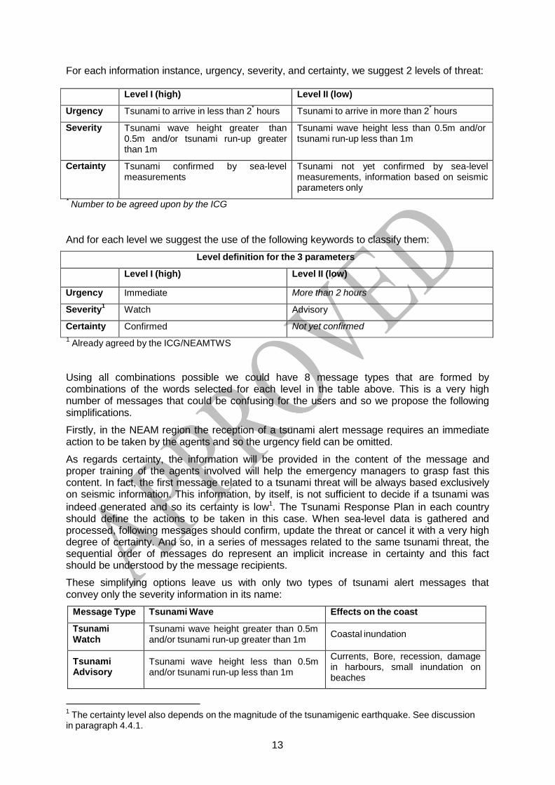
Level I (high) Level II (low)
Urgency Tsunami to arrive in less than 2* hours Tsunami to arrive in more than 2* hours
Severity Tsunami wave height greater than 0.5m and/or tsunami run-up greater than 1m
Tsunami wave height less than 0.5m and/or tsunami run-up less than 1m
Certainty Tsunami confirmed by sea-level measurements
Tsunami not yet confirmed by sea-level measurements, information based on seismic parameters only
Level definition for the 3 parameters
Level I (high) Level II (low)
Urgency Immediate More than 2 hours
Severity1 Watch Advisory
Certainty Confirmed Not yet confirmed
For each information instance, urgency, severity, and certainty, we suggest 2 levels of threat:
* Number to be agreed upon by the ICG
And for each level we suggest the use of the following keywords to classify them:
1 Already agreed by the ICG/NEAMTWS
Using all combinations possible we could have 8 message types that are formed by combinations of the words selected for each level in the table above. This is a very high number of messages that could be confusing for the users and so we propose the following simplifications.
Firstly, in the NEAM region the reception of a tsunami alert message requires an immediate action to be taken by the agents and so the urgency field can be omitted.
As regards certainty, the information will be provided in the content of the message and proper training of the agents involved will help the emergency managers to grasp fast this content. In fact, the first message related to a tsunami threat will be always based exclusively on seismic information. This information, by itself, is not sufficient to decide if a tsunami was indeed generated and so its certainty is low1. The Tsunami Response Plan in each country should define the actions to be taken in this case. When sea-level data is gathered and processed, following messages should confirm, update the threat or cancel it with a very high degree of certainty. And so, in a series of messages related to the same tsunami threat, the sequential order of messages do represent an implicit increase in certainty and this fact should be understood by the message recipients.
These simplifying options leave us with only two types of tsunami alert messages that convey only the severity information in its name:
Message Type Tsunami Wave Effects on the coast
Tsunami Watch
Tsunami wave height greater than 0.5m and/or tsunami run-up greater than 1m Coastal inundation
Tsunami Advisory
Tsunami wave height less than 0.5m and/or tsunami run-up less than 1m
Currents, Bore, recession, damage in harbours, small inundation on beaches
1 The certainty level also depends on the magnitude of the tsunamigenic earthquake. See discussion in paragraph 4.4.1.

14
In addition to the tsunami alert messages, we have to consider two additional types of messages, tsunami information and tsunami communication test. The Tsunami Information is a message issued to advise the NEAM recipients of the occurrence of a major earthquake in the area but with an evaluation that there is no tsunami threat. The thresholds for the issuing of this type of messages are defined in the Decision Matrixes for the Mediterranean and for the NE Atlantic, as agreed by the ICG/NEAMTWS (see below).
For the National Tsunami Warning Centres (NTWCs) it is recommended that a National Tsunami Information message could be sent in the case of an earthquake felt at or close to the coast, of any magnitude. The tsunami information message will then be used to prevent unnecessary evacuations most frequently.
The Tsunami Communication Test is a message issued by the TWPs at unannounced times to test the operation of the tsunami warning systems.
3.2.2 Structure of Messages, Affected Area and Sequence
In the NEAM region, due to its basin structure, there is no tsunami that can affect all countries with the same threat level. However, it could be confusing to send different messages to different countries referring to the same tsunami event. We propose that all National TWFP in the NEAM region will receive the same tsunami message. This means that the same message will contain in the same body more than one type of messages: tsunami watch, tsunami advisory, and tsunami information. We propose that the header part of the tsunami message should contain the sequence of pairs of fields, message type and affected area, by a decreasing order of threat. The type of such a composed message will be the one that corresponds to the highest level of tsunami threat. This means that some coastal area in the NEAM region is subject to that type of tsunami threat. Thus, a Tsunami Watch message will also contain a Tsunami Advisory and a Tsunami Information types of messages, while a Tsunami Advisory will contain also a Tsunami Information type of message.
The area affected by a certain tsunami threat is defined in the Decision Matrixes agreed by the ICG/NEAMTWS, according to 3 spatial ranges of tsunamis:
Tsunami range Mediterranean NE Atlantic Local < 100 km < 100 km
Regional 100 km to 400 km 100 km to 1000 km Basin > 400 km > 1000 km
The tsunami message type related to one given country is defined by the worst case that can be found on any coastal area of that country, set up according to the Decision Matrix.

15
Decision Matrix for the Mediterranean Depth Location Mw Tsunami Potential Type of Message
< 100 km
Offshore or close to the coast (≤ 40 km inland)
5.5 to 6.0 weak potential of local tsunami Information Message Local Tsunami Advisory
6.0 to 6.5 Potential of destructive local
tsunami < 100 km
Regional Tsunami Advisory Local Tsunami Watch
Offshore or close to the coast (≤ 100 km inland)
6.5 to 7.0
Potential of destructive regional tsunami < 400 km
Regional and Local Tsunami Watch - Basin-wide Tsunami Advisory
≥ 7.0
Potential of destructive tsunami in the whole basin > 400 km
Basin-wide Tsunami Watch
≥ 100 km
Offshore or inland (≤ 100 km)
≥ 5.5
Nil
Information Message
No message if the earthquake is localized inland beyond 100 km distance
Decision Matrix for the NE Atlantic Depth Location Mw Tsunami Potential Type of Message
< 100 km
Offshore or close to the coast (≤ 40 km inland)
5.5 to 6.0 weak potential of local tsunami Information Message
6.0 to 6.5 Potential of destructive local
tsunami < 100 km
Regional Tsunami Advidory
Offshore or close to the coast (≤ 100 km inland)
6.5 to 7.0
Potential of destructive regional tsunami < 400 km
Regional Tsunami Watch - Basin-wide Tsunami Advisory
≥ 7.0
Potential of destructive tsunami in the whole basin > 400 km
Basin-wide Tsunami Watch
Inland (> 40 km and ≤ 100 km)
5.5 to 7.0
weak potential of local tsunami Information
Message
≥ 100 km
Offshore or inland (≤ 100 km)
≥ 5.5
Nil
Information Message
No message if the earthquake is localized inland beyond 100 km distance

16
The Tsunami Information and Tsunami Communication Test messages will be singles. They will not be followed by any further message related to the same tsunami event. This will no be the case for Tsunami Alert Messages, Advisories and Watches.
When there is a tsunami threat that deserves the issuing of a Tsunami Alert Message, the threat must be followed by the NEAM TWPs and a sequence of messages is expected until the alert is ended or is cancelled after the observation of sea-level measurements.
The first tsunami alert message in a sequence related to a tsunami threat is based exclusively on seismic information. This information, by itself, is not sufficient to decide if a tsunami was indeed generated and so its certainty is low. The subsequent messages will already contain an evaluation of the tsunami threat with sea-level measurements. These supplement second messages may confirm the previous alert, change the level of alert or cancel it. If there is a significant change in the revised earthquake parameters, like its magnitude, location or focal depth, that change the estimated tsunami threat, then a supplement tsunami alert message may be sent by the TWP conveying this information.
A Tsunami Alert message is ended when the TWP estimates that the tsunami threat is over and no more tsunami waves are expected and its effects subdued.
Two situations are considered:
- a tsunami has been observed : the message is end of watch or end of advisory
- no tsunami was generated : the message is tsunami watch cancelation or tsunami advisory cancelation
This message cannot be interpreted as an “all-clear” message. The issuing of “all-clear” messages is a national responsibility of the emergency managers and should take into account the local safety conditions (see also paragraph 4.6.4.).
Any Tsunami Alert Sequence is then composed of one initial message; zero, one or more supplement messages and is always finished by an end of alert or alert cancellation message. The sequencing of tsunami messages is summarized in the table below.
Sequencing in Tsunami Messages
Message Type #1 #2 … #N-1 #N
Tsunami Watch Initial supplement (0, 1 or more) end of watch
or watch cancellation
Tsunami Advisory Initial supplement (0, 1 or more) end of advisory
or advisory cancellation
Tsunami Information Single Tsunami Communication Test Single
3.2.3 Tsunami Forecast Points
As part of their standard operating procedures for responding to potentially tsunamigenic events, the TWPs in the NEAM region calculate expected tsunami arrival times (ETA) to various, pre-determined forecast points. Forecast points are agreed-upon points chosen by the TWPs and countries. They may correspond to important coastal cities or populations, and/or to the locations of sea level gauges. In addition, some of the TWPs (and/or NTWCs) may be able also to forecast tsunami wave amplitudes at the forecast points in order to decide on the level of potential tsunamigenic threat (see Figure 1 for a definition of the concepts).

17
In the NEAM region, the level of threat for a given country or region is defined in terms of its distance to the earthquake source and not by the estimated tsunami arrival time, as it happens in Pacific, for example (see the Decision Matrixes above).
When a country is in a Watch or Advisory status only, the ETAs for its forecast points that meet the criteria will be listed in the tsunami alert messages issued by the TWPs.
Message recipients should be aware that the estimated arrival times given in tsunami alert messages should only be used as general guidance about when a tsunami impact might commence. This is due to the dependency of propagation speed on the bottom topography and morphology, especially near-shore where the accuracy of the calculation is most heavily dependent on the accuracy of the bathymetry. As a consequence actual arrival times of the first-arriving significant wave may vary substantially from the predicted times. Thus, the primary value of quickly calculating an estimated tsunami arrival time is to provide immediate guidance to the TWPs, National TWFP, NTWC, and to other emergency response stakeholders responsible for issuing and acting upon tsunami alerts to ensure public safety.
Figure 1 – Definition of the main parameters that are communicated between TWP, National TWFP, NTWC and emergency managers: (i) the estimated tsunami arrival time (ETA); (ii) the maximum
tsunami amplitude. Adapted from the Tsunami Glossary, by IOC/ITIC.
The list of Tsunami Forecast Points submitted to the IOC Secretariat as of 3 March 2011 is included in Annex III.
3.2.4 Tsunami Message Identifiers
To be prepared by the Task Team on Communication Test and Tsunami Exercises.

18
SECTION 4 – THE PROVISION OF TSUNAMI WATCHES 4.1 INTRODUCTION
This section is conceived to apply to any generic candidate to a TWP in the NEAM region, the NEAM-TWPs. The section will be updated as TWPs will enter into operation.
4.2 SEA BASIN
The sea basins included in the NEAM region are all interconnected, but they can hardly be involved altogether by the same tsunami or other coastal inundation hazard event, irrespective of its size (see Figure 2). For example, straits like the Bosporus form an obstacle difficult to overcome for all tsunamis that occur in the Black Sea that cannot penetrate in the next Marmara Sea. Likewise, the Gibraltar straits are a natural barrier for tsunamis generated in the Atlantic Ocean (see the 1755 case) that attenuate strongly while crossing this strait as well as for tsunamis produced in the Mediterranean Sea. The same is true for tsunamis across the Messina straits, Italy, which divides the Tyrrhenian Sea from the Ionian Sea. In addition, one may identify other less effective barriers preventing the free propagation of tsunamis, such as the broad and relatively shallow Sicily channel between eastern and western Mediterranean.
Figure 2 – The main basins in the NEAM region.

19
4.3 OPERATIONAL PROCEDURES 4.3.1 Response and Analysis
The TWP initiates its functions with the detection of an earthquake of sufficient size to trigger a message at the NEAM-TWP. Given the short distance of the tsunamigenic sources to the coast in the NEAM region, the seismic waveforms start to be collected at the TWP only a few seconds after the onset of the earthquake. The TWP duty personnel will respond immediately and begin their analysis of the event. The NEAM-TWPs are staffed on a 24x7 basis to be able to respond quickly to any tsunamigenic earthquake. It is desirable that a first evaluation of the earthquake parameters is computed in less than 5 minutes after its origin time. The earthquake analysis includes automatic and interactive processes for determining the earthquake's epicentre, depth, and origin time, as well as its magnitude. The magnitude scale adopted by the ICG/NEAMTWS is the moment magnitude, MW. Normally, the first estimates of MW have to be derived from a small length of the seismic waveforms by some standard procedures that have been agreed upon by the ICG/NEAMTWS. The earthquake evaluation will continue after the first message is issued, integrating more data and allowing more extensive analysis. If there are significant changes to the initial parameters, then the NEAM-TWP may decide to issue a supplement message.
Applying the Tsunami Decision Matrix to the earthquake parameters will provide the appropriate message type that will be issued by the NEAM-TWP. Whenever any kind of tsunami alert is issued (Watch or Advisory), as well as for near-watch-level events, the NEAM-TWP will continuously monitor the water level data from the sea level stations located near the epicentre, and from deep ocean sea level gauges, for evidence of a tsunami. Based on these data and on any credible reports of tsunami wave activity from national agencies or the media, and using historical data and numerical forecast model outputs for decision guidance, an evaluation of the tsunami threat is made and updated. If a tsunami has been generated that poses a continuing threat, the current level of alert will continue, or be upgraded, or be downgraded, until the tsunami waves no longer cause a threat to the coastal areas.
In response to a NEAM-TWP Watch or Advisory tsunami message, national or regional authorities must implement their own pre-determined procedures that can include issuing evacuation instructions to coastal areas when appropriate. If sea level and all other data indicate, however, that a destructive tsunami has not been generated, or that there is no tsunami threat, then the NEAM-TWP issues a tsunami alert cancellation. This will be most often the case since most large earthquakes with the potential to generate a destructive tsunami do not actually do so, and also because the Decision Matrix thresholds are conservative.
It is desirable that in the NEAM region the TWP should be able to issue the first tsunami message between 5 and 15 minutes after the onset of the earthquake, depending upon the spatial density of nearby seismic stations, with an accuracy in magnitude less than 0.3 and in epicentre location, less than 20-30 km. This fast response maybe however not enough for the closest coastal areas, in case a local tsunami is generated. In the areas threatened by local tsunamis, at-risk populations need to be educated about natural warning signs such as strong shaking from the earthquake or a withdrawal of the sea, and be ready to immediately evacuate when such signs occur.
Subsequent tsunami messages related to the same event, which include already information on sea-level measurements, will be issued as soon as this information is available and properly processed. The time line of these messages depends strongly on the distribution of coastal and deep-ocean sea-level gauges in the area surrounding the earthquake.

20
4.3.2 Message Types and Criteria The NEAM-TWP will adopt the tsunami message type and criteria as described in section 3.6 of this document.
4.4 OPERATIONAL LIMITATIONS
The science of rapidly and accurately forecasting tsunamis has made important strides in recent years but challenges remain. Limitations of NEAM-TWP operational tsunami alerts should be known and understood in order to best plan for and execute an appropriate response.
4.4.1 Earthquake Parameters
Earthquake parameters provide the earliest indication of a potential tsunami because seismic waves travel much faster inside the earth than tsunami waves. Consequently, the earliest initial tsunami messages are based entirely on the preliminary earthquake parameters. However, most large earthquakes with the potential to generate a destructive tsunami actually do not do so, and consequently most tsunami alert messages based on the preliminary earthquake parameters will eventually be cancelled afterwards when significant tsunami waves are not observed.
A number of factors contribute to this limitation including: 1) the tsunami is generated primarily by earthquake induced vertical seafloor displacements and to estimate the vertical seafloor displacement, a precise determination of the focal depth and focal mechanism are needed, not currently available in the short delay of dissemination (less than 15 minutes) ; Consequently : 2) the magnitude threshold for watches is set at a conservative level to ensure that a significant tsunami is not missed; 3) the magnitude threshold is further set at a conservative level to take into account uncertainties in the preliminary magnitude; and 4) there are many more earthquakes with magnitudes near the conservative threshold than ones far above it where a destructive tsunami is more certain.
4.4.2 Initial Estimated Tsunami Arrival Times
The NEAM-TWP’s initial estimated tsunami arrival times (ETA) are typically computed from the epicentre of the earthquake to each forecast point using the minimum-path ray-tracing approximation: a wave will travel from point A to point B over whatever path in space (the ocean in this case) that gets it there the fastest. There are several limitations to this method. The first one is the inaccuracy of representing the tsunami source by a point located at the epicentre. For great earthquakes, the ones most likely to produce a tsunami, the ocean- bottom displacement caused by the earthquake rupture will start at the epicentre but it can extend for tens or even hundreds of kilometres away from the epicentre. As a consequence, the tsunami source may not be like a point and the largest displacement may not be located at the epicentre.
The second limitation is that the fastest path from the epicentre to the forecast point may not be a path over which much energy has travelled. A third limitation arises from the fact that the fast ray-tracing algorithms used neglect the non-linear interaction between the tsunami waves and the bottom relief in shallow waters. Incidentally, these effects tend to reduce the speed of the tsunami and so usually the ETA may be considered as the “fastest scenario” (but be aware of limitation one). Finally, this method also neglects the fine details of the near- shore bathymetry and the coastline that affect the tsunami impact on the shore.
Consequently, the first arriving tsunami waves may be small compared to later arriving waves and its travel time can be different from the estimated. The net result of these limitations is that significant tsunami waves may arrive tens of minutes sooner or later than the predicted arrival time and that such errors may be largest in the biggest events.

21
At present it is not possible to quickly know the precise dimensions or location of the extended tsunami source. A good estimation of these parameters may be available some minutes after the issuing of the first message and might be used to update the level of tsunami alert and re-compute the ETA using an extended source model.
In addition to ETA, some NEAM-TWP (and/or NTWC) may provide also estimates for the tsunami wave height at the pre-defined coastal forecast points. The wave heights are obtained from a scenario database that must include all the possible tsunami locations and relevant earthquake magnitudes. The limitations of the computation of the wave heights, if these values are provided, must also be properly understood by the tsunami message recipients.
Tsunami Forecast models that use deep-ocean sea level readings to define in real-time the tsunami source and estimate ETA and tsunami wave heights at the coast have already been tested in the Pacific and Indian Oceans. The conclusion is that the methodology looks promising in areas where the tsunami wave takes hours to impact the coast. However, these Tsunami Forecast models are still untested for the NEAM region where tsunamigenic sources are very close to the shore and geometry of the sources not well known and the first tsunami waves take less than 30 minutes to reach the coast.
4.4.3 Area of Watches and Advisories
The NEAM-TWP will put any particular coastal area in the NEAM region into a watch or advisory based on the Tsunami Decision Matrixes presented in section 3. The particular basin geometry of the NEAM region could prevail over the simple distance criteria used in the decision matrix, but this should be decided case by case (see paragraph 4.3).
Historical data and numerical model outputs show that tsunamis do not affect all areas equally, even inside the same basin. Significant differences can be due to directionality associated with the source, focusing and defocusing by bathymetry, attenuation by spreading and friction, and blockage by land masses. Consequently, some areas that are put into watch or advisory status may not actually be threatened. As the forecasting capabilities of the NEAM-TWPs become quicker and more accurate in coming years due to improved earthquake analyses, more deep ocean data, and improved numerical forecast models, then tsunami alert messages can be based on expected tsunami amplitudes instead of expected arrival times or distances from the epicentre. For now, this more conservative and simplified approach is considered the most adequate.
4.5 TYPES OF NEAM-TWP MESSAGES
As described in section 3, the NEAM-TWP issues three basic types of messages in response to large earthquakes or other potential tsunami events. A fourth type of message is issued between events to test communication links. To avoid confusion among National TWFPs and emergency managers, only one message is issued related to the same tsunamigenic event, regardless of the tsunami threat level at any particular area. In this way, each message body may contain inside different levels of alert messages. The descriptions that follow apply not to whole messages, but to the part of the message with the corresponding alert level. In a tsunami message, the highest alert level will always be presented first.
4.5.1 Tsunami Watch Message
A tsunami watch message is issued by the NEAM-TWP whenever the seismic information or/and sea-level data indicates that any area of the NEAM coast line may be impacted by a tsunami wave height greater than 0.5 m, and/or when tsunami run-up is expected to be higher than 1 m. The certainty degree of the watch depends on the data that are used to make the tsunami threat evaluation, and also on the magnitude of the earthquake. Messages based on seismic data only will have a low degree of certainty, but the probability that a

22
destructive tsunami has been generated increases with its magnitude. A tsunami Watch is the highest severity level of a tsunami alert message and it must be considered that the tsunami waves, if generated, pose a real threat to coastal populations and may cause destruction along the shoreline.
The initial message will be followed always by one or more additional messages related to the same event.
Continuing observation of sea level and collection of seismic data will determine the content of the supplement message(s) to be issued by the NEAM-TWP. This level of alert can be confirmed, downgraded or cancelled. If a tsunami is confirmed by sea-level observations or other reports, then the NEAM-TWP last message in the sequence must be an “end-of-alert” message. Upon the receipt of a tsunami watch message, National TFPs, NTWCs and emergency management agencies in all affected countries should evaluate the probability of a tsunami impacting their area and carry out appropriate actions according to their predetermined standard operating procedures (Tsunami Response Plan).
4.5.2 Tsunami Advisory Message
A tsunami advisory message is issued by the NEAM-TWP whenever the seismic information or/and sea-level data indicates that any area of the NEAM coast line may be impacted a tsunami wave height from 0.2 to 0.5 m, and/or when tsunami run-up is expected to be lower than 1 m.
The certainty degree of the advisory depends on the data that was used to make the tsunami threat evaluation, and also on the magnitude of the earthquake. Messages based on seismic data only will have a low degree of certainty, but the probability that a tsunami has been generated increases with its magnitude. The tsunami advisory is the second level of severity in a tsunami alert and in this case the effects on the coast are reduced and no extensive destruction is expected. No evacuation is usually required. However, the tsunami waves can cause bores, strong currents, recession of the sea and small inundation on beaches. Resonance can cause damage on harbours and disrupt harbour operations. Adequate actions are recommended, like averting people and boats along the coastline, take out swimmers from the water, averting harbour authorities.
The Initial message will be followed always by one or more additional messages related to the same event.
Continuing observation of sea level and collection of seismic data will determine the content of the supplement message(s) to be issued by the NEAM-TWP. The level of alert can be confirmed, upgraded or cancelled. If a tsunami is confirmed by sea-level observations or other reports, then the NEAM-TWP last message in the sequence must be an “end-of-alert” message. Upon the receipt of a tsunami advisory message, National TFPs, NTWCs and emergency management agencies in all affected countries should evaluate the probability of a tsunami impacting their area and carry out appropriate actions according to their predetermined standard operating procedures (Tsunami Response Plan).
4.5.3 Tsunami Information Message
This is a message issued to advise NEAM recipients on the occurrence of a major earthquake in the NEAM region but with an evaluation that there is no tsunami threat.
4.5.4 Tsunami Communication Test Message
This is a test message issued by the NEAM-TWP, usually at unannounced times, to determine delays in disseminating tsunami messages by different methods of transmission (GTS, Internet, …), to test the operation of the warning system by requiring a response, and to keep NEAM-TWP operations personnel familiar with the procedures for handling tsunami message traffic. It is recommended that communication tests should take place

23
approximately four times per year. Results of communication tests will be provided to all other NEAM-TWPs and the ICG/NEAMTWS to facilitate the performance monitoring of the TWP.
4.5.5 Tsunami Exercise Messages
These are Exercise messages issued by a TWC, organised by the ICG, to initiate an exercise that will test the performance of the Regional Coordination of the NEAM-TWPs and, if desired, it could also trigger a National Tsunami Exercise in the MB that desire so. These exercises correspond in general to the watch level in a specific sub-basin, and information for the other sub-basins. Unlike the Communication Test Messages, the Tsunami Exercise Messages must be very well planned and integrated in a Tsunami Exercise. These messages will be identical to ordinary Watch and Information messages, but they exercise status will be declared in the first statement of the message, to avoid any unnecessary confusion.
4.6 NEAM-TWP ALERT STATUS DEFINITIONS
4.6.1 Tsunami Watch
A tsunami watch is issued by the NEAM-TWP when a potential tsunami with significant widespread inundation is expected. Watches alert the National TWFPs, the NTWCs and the emergency management agencies that widespread, dangerous coastal flooding accompanied by powerful currents is possible and may continue for several hours after arrival of the initial wave. Watches alert emergency management officials to take action for the entire tsunami hazard zone. Appropriate actions to be taken by local officials may include the evacuation of low-lying coastal areas, and the repositioning of ships to deep waters when there is time to safely do so. Watches may be updated, adjusted geographically, downgraded, or cancelled. To provide the earliest possible alert, initial tsunami watch messages are based only on seismic information.
4.6.2 Tsunami Advisory
A tsunami advisory is issued by the NEAM-TWP when a tsunami with a small inundation potential is expected in very specific areas. In this case the effects of the tsunami on the coast are reduced and no extensive destruction is expected. No evacuation is usually required. However, the effects of the tsunami can cause bores, strong currents, recession of the sea and small inundation on beaches or along river shores. Resonance can cause damage on harbours and disrupt harbour operations. These effects may continue for up to a few hours. Advisories alert the National TWFPs, the NTWCs and the emergency management agencies to take appropriate actions for the entire tsunami hazard zone, like averting people and boats along the coastline, take out swimmers from the water, averting harbour authorities. Advisories may be updated, adjusted geographically, upgraded, or cancelled. To provide the earliest possible alert, initial advisory messages are based only on seismic information.
4.6.3 Tsunami Information
Tsunami information is in fact a “non-alert” level and it is issued to inform that an earthquake has occurred but it has no potential to generate a tsunami. The tsunami information message will be used to prevent unnecessary evacuations as the earthquake may have been strongly felt in coastal areas.

24
4.6.4 End of Tsunami Alert (Watch or Advisory) An “All Clear”, or its equivalent, is usually issued by local authorities following any type of near or actual disaster to inform the public that it is safe to re-enter evacuated areas and resume normal activities.
Following a tsunami, the NEAM-TWP will issue a tsunami end of alert message when observations, modelling and historical records show that the disturbances due to the tsunami wave subsided. However, the NEAM-TWP does not receive enough data to determine when the danger has passed in all coastal areas. Local conditions can cause wide variations in tsunami wave action and additional hazards such as fires, chemical spills, or downed power lines may exist following a destructive tsunami. Consequently, “All Clear” determinations must be made by local authorities and not by the NEAM-TWP. In general, local authorities can assume the tsunami danger has passed when their area is free from damaging waves for at least 2 hours after the last destructive wave, or if no destructive waves have occurred for at least two hours after the expected tsunami arrival time. Local conditions including seiching in bays and harbours, wave resonance along continental shelves, and strong currents in channels and harbours can persist for many hours and delay the “All Clear”.
4.6.5 Tsunami Alert Cancellation (Watch or Advisory)
A tsunami alert cancellation indicates the end of the damaging tsunami threat, when no tsunami occurrence is confirmed.
4.7 NEAM-TWP TEXT MESSAGES FORMAT AND CONTENT
The NEAM-TWP text messages are composed of the following key elements: 4.7.1 Message Header (MH)
The Message Header has three lines. The first line indicates that this is a tsunami message, a tsunami exercise message or a tsunami communication test message.
It shows the sequential number of the message. Messages are numbered starting with 1 for each event and continue in sequence. Numbers continue to increment, even if the alert level changes from one type of message to another (e.g., from a Tsunami Advisory to a Tsunami Watch). The second line indicates the issuing office, the NEAM-XXX-TWP (where XXX is the name of the centre). The third line indicates the date and time that the message was issued.
All times used in tsunami messages are referred to UTC. It is the responsibility of National TWFPs, NTWCs and emergency management agencies to translate the time information to each country local time, if necessary.
All 3 possible message first line would be :
TSUNAMI MESSAGE NUMBER 002 TSUNAMI EXERCISE MESSAGE NUMBER 001 TSUNAMI COMMUNICATION TEST MESSAGE NUMBER 001
Sample Message Header
TSUNAMI MESSAGE NUMBER 002 NEAM XXX TSUNAMI WATCH PROVIDER ISSUED AT 1010Z 01 NOV 2014
25
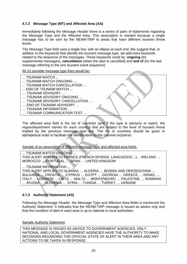
4.7.2 Message Type (MT) and Affected Area (AA) Immediately following the Message Header there is a series of pairs of statements regarding the Message Type and the Affected Area. This association is needed because a single message has to be sent by the NEAM-TWP to areas that have different tsunami threat levels.
The Message Type field uses a single line, with an ellipsis at each end. We suggest that, in addition to the keywords that identify the tsunami message type, we add extra keywords related to the sequence of the messages. These keywords could be: ongoing (for supplemental messages), cancellation (when the alert is cancelled) and end of (for the last message referring to the one tsunami event sequence)
All 10 possible message type lines would be:
... TSUNAMI WATCH ...
... TSUNAMI WATCH ONGOING ...
... TSUNAMI WATCH CANCELLATION ...
... END OF TSUNAMI WATCH ... … TSUNAMI ADVISORY … … TSUNAMI ADVISORY ONGOING … … TSUNAMI ADVISORY CANCELLATION … … END OF TSUNAMI ADVISORY … … TSUNAMI INFORMATION … … TSUNAMI COMMUNICATION TEST …
The affected area field is the list of countries (and if the type is advisory or watch, the region/department names for each country) that are subject to the level of tsunami threat implied by the previous message type line. The list of countries should be given in alphabetical order to facilitate the identification by the national recipients.
Sample of an association of different message type and affected area fields
... TSUNAMI WATCH ONGOING ... THIS ALERT APPLIES TO FRANCE (FRENCH RIVIERA, LANGUEDOC...)… IRELAND … MOROCCO … PORTUGAL … SPAIN … UNITED KINGDOM
... TSUNAMI INFORMATION ... THIS ALERT APPLIES TO ALBANIA … ALGERIA … BOSNIA AND HERZEGOVINA … BULGARIA … CROATIA … CYPRUS … EGYPT … GEORGIA … GREECE … ISRAEL … ITALY … LEBANON … LIBYA … MALTA … MONTENEGRO … PALESTINE … ROMANIA … RUSSIA … SLOVENIA … SYRIA … TUNISIA … TURKEY … UKRAINE
4.7.3 Authority Statement (AS)
Following the Message Header, the Message Type and Affected Area fields is mentioned the Authority Statement. It indicates that the NEAM-TWP message is issued as advice only and that the condition of alert in each area is up to national or local authorities.
Sample Authority Statement
THIS MESSAGE IS ISSUED AS ADVICE TO GOVERNMENT AGENCIES. ONLY NATIONAL AND LOCAL GOVERNMENT AGENCIES HAVE THE AUTHORITY TO MAKE DECISIONS REGARDING THE OFFICIAL STATE OF ALERT IN THEIR AREA AND ANY ACTIONS TO BE TAKEN IN RESPONSE.

26
4.7.4 Earthquake Parameters (EP)
Following the Authority Statement comes the Earthquake Parameters. In the initial message of a tsunami alert sequence the earthquake parameters are preliminary since they are determined quickly for tsunami purposes. They may be revised following the initial message as more data are received and analysed. Small differences between these parameters and those that may be issued by other earthquake reporting agencies are normal. The magnitude reported is Mw or some fast estimate of it. Time is UTC. The location is the country and the sub-basin of the epicenter, in case of an earthquake close to a country, or a sub-basin in case of an epicenter far from the coast.
Sample Earthquake Parameters
AN EARTHQUAKE HAS OCCURRED WITH THESE PRELIMINARY PARAMETERS ORIGIN TIME - 0940Z 01 NOV 2014 COORDINATES – 35.90 NORTH 10.22 WEST DEPTH - 30 KM LOCATION – North-Eastern ATLANTIC, PORTUGAL MAGNITUDE – 8.5
4.7.5 Tsunami Wave Measurements (TM)
When such data become available, usually after the issuing of the initial message, the NEAM-TWP will report tsunami wave measurements from key coastal and deep ocean gauges. Each measurement includes the name of the gauge, the coordinates of the gauge, the time of the measurement, the maximum amplitude of the wave in meters observed so far, and the period of the wave cycle in minutes, if available (see Figure 1). These measurements, while generally indicative of whether a tsunami has been generated and the size of the tsunami, should only be further interpreted by experts. The character of tsunami waves in the deep ocean and at the shore is outside normal human experience and is non- intuitive. For example, a tsunami measuring only a few centimetres on a deep ocean gauge can create flooding at the shore. In addition, because new waves could be recorded, values reported for a particular gauge may change significantly from one message to the next.
When a gauge location is similar to a forecast point location (see 3.7.3 and 4.7.7), the computed arrival time and estimated level of watch and the measured arrival time and amplitude will be indicated in the same line.
Sample Tsunami Wave Measurements
MEASUREMENTS OR REPORTS OF TSUNAMI WAVE ACTIVITY GAUGE LOCATION LAT LON TIME AMPL PER ------------------- ----- ------ ----- --------------- ----- PORTUGAL - LAGOS 37.06N 8.73W 1003Z 2.44M 12MIN PORTUGAL - SINES 37.97N 8.89W 1007Z 2.25M 7MIN LAT - LATITUDE (N-NORTH, S-SOUTH) LON - LONGITUDE (E-EAST, W-WEST) TIME - TIME OF THE MEASUREMENT (Z IS UTC TIME) AMPL - TSUNAMI AMPLITUDE MEASURED RELATIVE TO NORMAL SEA LEVEL. IT IS ...NOT... CREST-TO-TROUGH WAVE HEIGHT. VALUES ARE GIVEN IN METERS (M). PER - PERIOD OF TIME IN MINUTES (MIN) FROM ONE WAVE TO THE NEXT.

27
4.7.6 Evaluation Statement (ES)
All messages contain an evaluation statement. This is a general statement of the current situation along with an assessment of the tsunami threat. It may also contain advice regarding the appropriate response actions. It will contain the information regarding the certainty of the tsunami alert message that is required by the message recipients to take appropriate actions, according to their Tsunami Response Plan. Since a single message is sent to recipients with different levels of tsunami threat, we suggest that the type of message should be included in the first line of the Evaluation Statement field. This will inform the message recipient if the following evaluation applies or not to its region. All Possible Evaluation Statements are shown below.
Tsunami Watch Initial
EVALUATION OF TSUNAMI WATCH IT IS NOT KNOWN THAT A TSUNAMI WAS GENERATED. THIS MESSAGE IS BASED ONLY ON THE EARTHQUAKE EVALUATION. AN EARTHQUAKE OF THIS SIZE HAS THE POTENTIAL TO GENERATE A TSUNAMI THAT CAN STRIKE COASTLINES WITH A WAVE HEIGHT GREATER THAN 0.5M AND/OR CAUSE A TSUNAMI RUN-UP GREATER THAN 1M. AUTHORITIES SHOULD TAKE APPROPRIATE ACTION IN RESPONSE TO THIS POSSIBILITY. THIS CENTER WILL MONITOR SEA LEVEL DATA FROM GAUGES NEAR THE EARTHQUAKE TO DETERMINE IF A TSUNAMI WAS GENERATED AND ESTIMATE THE SEVERITY OF THE THREAT. A TSUNAMI IS A SERIES OF WAVES AND THE FIRST WAVE MAY NOT BE THE LARGEST. TSUNAMI WAVE HEIGHTS CANNOT BE PREDICTED AND CAN VARY SIGNIFICANTLY ALONG A COAST DUE TO LOCAL EFFECTS. THE TIME FROM ONE TSUNAMI WAVE TO THE NEXT CAN BE FIVE MINUTES TO AN HOUR, AND THE THREAT CAN CONTINUE FOR MANY HOURS AS MULTIPLE WAVES ARRIVE.
Tsunami Watch Supplement
EVALUATION OF TSUNAMI WATCH SEA LEVEL READINGS INDICATE A TSUNAMI WAS GENERATED. THIS TSUNAMI CAN STRIKE COASTLINES WITH A WAVE HEIGHT GREATER THAN 0.5M AND/OR CAUSE A TSUNAMI RUN-UP GREATER THAN 1M. THIS CENTER WILL CONTINUE TO MONITOR SEA LEVEL GAUGES NEAREST THE REGION AND REPORT IF ANY ADDITIONAL TSUNAMI WAVE ACTIVITY IS OBSERVED. AUTHORITIES SHOULD TAKE APPROPRIATE ACTION IN RESPONSE TO THIS POSSIBILITY. A TSUNAMI IS A SERIES OF WAVES AND THE FIRST WAVE MAY NOT BE THE LARGEST. TSUNAMI WAVE HEIGHTS CANNOT BE PREDICTED AND CAN VARY SIGNIFICANTLY ALONG A COAST DUE TO LOCAL EFFECTS. THE TIME FROM ONE TSUNAMI WAVE TO THE NEXT CAN BE FIVE MINUTES TO AN HOUR, AND THE THREAT CAN CONTINUE FOR MANY HOURS AS MULTIPLE WAVES ARRIVE.
End of Tsunami Watch
EVALUATION OF TSUNAMI WATCH SEA LEVEL READINGS INDICATE A TSUNAMI WAS GENERATED.
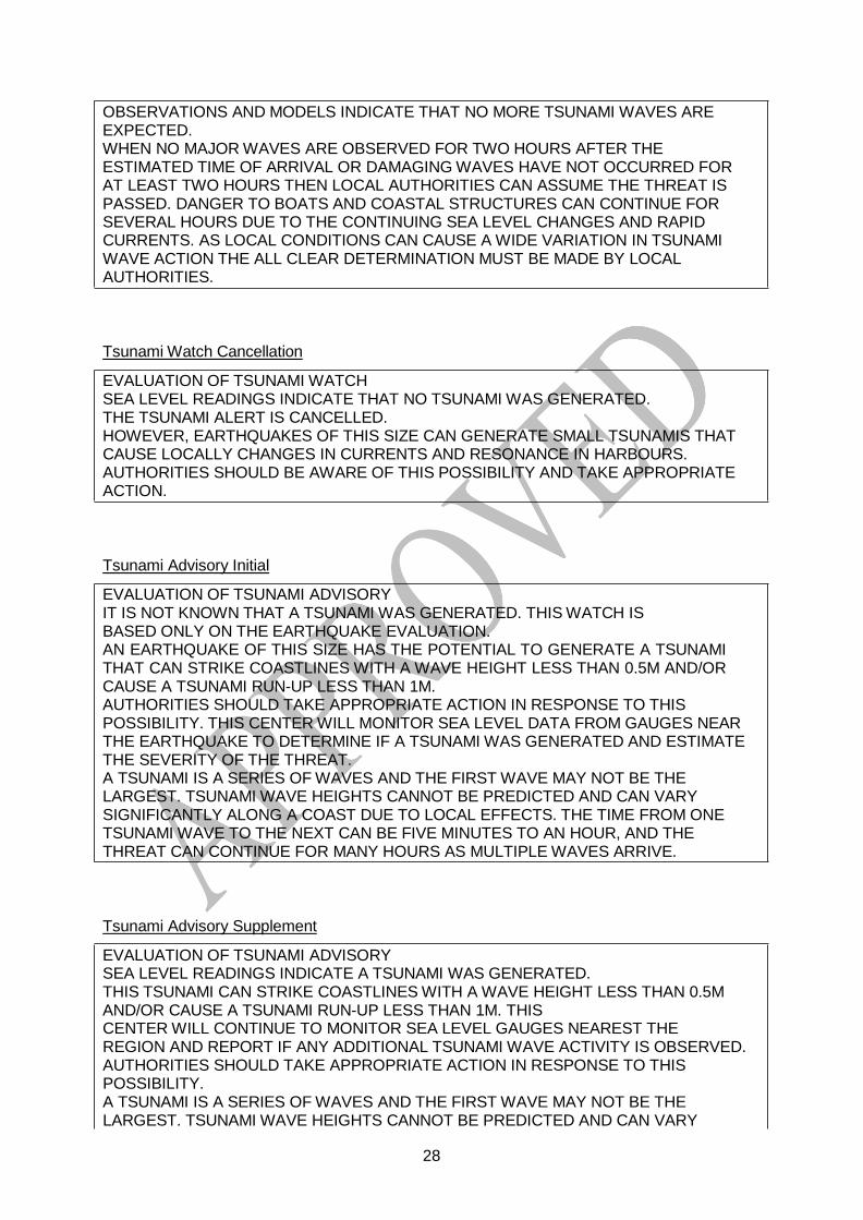
OBSERVATIONS AND MODELS INDICATE THAT NO MORE TSUNAMI WAVES ARE EXPECTED. WHEN NO MAJOR WAVES ARE OBSERVED FOR TWO HOURS AFTER THE ESTIMATED TIME OF ARRIVAL OR DAMAGING WAVES HAVE NOT OCCURRED FOR AT LEAST TWO HOURS THEN LOCAL AUTHORITIES CAN ASSUME THE THREAT IS PASSED. DANGER TO BOATS AND COASTAL STRUCTURES CAN CONTINUE FOR SEVERAL HOURS DUE TO THE CONTINUING SEA LEVEL CHANGES AND RAPID CURRENTS. AS LOCAL CONDITIONS CAN CAUSE A WIDE VARIATION IN TSUNAMI WAVE ACTION THE ALL CLEAR DETERMINATION MUST BE MADE BY LOCAL AUTHORITIES.
Tsunami Watch Cancellation
EVALUATION OF TSUNAMI WATCH SEA LEVEL READINGS INDICATE THAT NO TSUNAMI WAS GENERATED. THE TSUNAMI ALERT IS CANCELLED. HOWEVER, EARTHQUAKES OF THIS SIZE CAN GENERATE SMALL TSUNAMIS THAT CAUSE LOCALLY CHANGES IN CURRENTS AND RESONANCE IN HARBOURS. AUTHORITIES SHOULD BE AWARE OF THIS POSSIBILITY AND TAKE APPROPRIATE ACTION.
Tsunami Advisory Initial
EVALUATION OF TSUNAMI ADVISORY IT IS NOT KNOWN THAT A TSUNAMI WAS GENERATED. THIS WATCH IS BASED ONLY ON THE EARTHQUAKE EVALUATION. AN EARTHQUAKE OF THIS SIZE HAS THE POTENTIAL TO GENERATE A TSUNAMI THAT CAN STRIKE COASTLINES WITH A WAVE HEIGHT LESS THAN 0.5M AND/OR CAUSE A TSUNAMI RUN-UP LESS THAN 1M. AUTHORITIES SHOULD TAKE APPROPRIATE ACTION IN RESPONSE TO THIS POSSIBILITY. THIS CENTER WILL MONITOR SEA LEVEL DATA FROM GAUGES NEAR THE EARTHQUAKE TO DETERMINE IF A TSUNAMI WAS GENERATED AND ESTIMATE THE SEVERITY OF THE THREAT. A TSUNAMI IS A SERIES OF WAVES AND THE FIRST WAVE MAY NOT BE THE LARGEST. TSUNAMI WAVE HEIGHTS CANNOT BE PREDICTED AND CAN VARY SIGNIFICANTLY ALONG A COAST DUE TO LOCAL EFFECTS. THE TIME FROM ONE TSUNAMI WAVE TO THE NEXT CAN BE FIVE MINUTES TO AN HOUR, AND THE THREAT CAN CONTINUE FOR MANY HOURS AS MULTIPLE WAVES ARRIVE.
Tsunami Advisory Supplement
EVALUATION OF TSUNAMI ADVISORY SEA LEVEL READINGS INDICATE A TSUNAMI WAS GENERATED. THIS TSUNAMI CAN STRIKE COASTLINES WITH A WAVE HEIGHT LESS THAN 0.5M AND/OR CAUSE A TSUNAMI RUN-UP LESS THAN 1M. THIS CENTER WILL CONTINUE TO MONITOR SEA LEVEL GAUGES NEAREST THE REGION AND REPORT IF ANY ADDITIONAL TSUNAMI WAVE ACTIVITY IS OBSERVED. AUTHORITIES SHOULD TAKE APPROPRIATE ACTION IN RESPONSE TO THIS POSSIBILITY. A TSUNAMI IS A SERIES OF WAVES AND THE FIRST WAVE MAY NOT BE THE LARGEST. TSUNAMI WAVE HEIGHTS CANNOT BE PREDICTED AND CAN VARY
28

29
SIGNIFICANTLY ALONG A COAST DUE TO LOCAL EFFECTS. THE TIME FROM ONE TSUNAMI WAVE TO THE NEXT CAN BE FIVE MINUTES TO AN HOUR, AND THE THREAT CAN CONTINUE FOR MANY HOURS AS MULTIPLE WAVES ARRIVE.
End of Tsunami Advisory
EVALUATION OF TSUNAMI ADVISORY SEA LEVEL READINGS INDICATE A TSUNAMI WAS GENERATED. OBSERVATIONS AND MODELS INDICATE THAT NO MORE TSUNAMI WAVES ARE EXPECTED. WHEN NO MAJOR WAVES ARE OBSERVED FOR TWO HOURS AFTER THE ESTIMATED TIME OF ARRIVAL OR DAMAGING WAVES HAVE NOT OCCURRED FOR AT LEAST TWO HOURS THEN LOCAL AUTHORITIES CAN ASSUME THE THREAT IS PASSED. DANGER TO BOATS AND COASTAL STRUCTURES CAN CONTINUE FOR SEVERAL HOURS DUE TO THE CONTINUING SEA LEVEL CHANGES AND RAPID CURRENTS. AS LOCAL CONDITIONS CAN CAUSE A WIDE VARIATION IN TSUNAMI WAVE ACTION THE ALL CLEAR DETERMINATION MUST BE MADE BY LOCAL AUTHORITIES.
Tsunami Advisory Cancellation
EVALUATION OF TSUNAMI ADVISORY SEA LEVEL READINGS INDICATE THAT NO TSUNAMI WAS GENERATED. THE TSUNAMI ALERT IS CANCELLED. HOWEVER, EARTHQUAKES OF THIS SIZE CAN GENERATE SMALL TSUNAMIS THAT CAUSE LOCALLY CHANGES IN CURRENTS AND RESONANCE IN HARBOURS. AUTHORITIES SHOULD BE AWARE OF THIS POSSIBILITY AND TAKE APPROPRIATE ACTION.
Tsunami Information
EVALUATION OF TSUNAMI INFORMATION BASED ON HISTORICAL EARTHQUAKE AND TSUNAMI MODELLING THERE IS NO THREAT THAT A TSUNAMI HAS BEEN GENERATED THAT CAN CAUSE DAMAGE OR MAJOR EFFECT IN THE REGION. THIS MESSAGE IS FOR INFORMATION ONLY.
Tsunami Communication Test
FROM – NEAM – TSUNAMI WATCH PROVIDER TO - DESIGNATED 24-HOUR TSUNAMI WARNING FOCAL POINTS OF THE NEAM REGION FOR THE FOLLOWING COUNTRIES: ALBANIA … ALGERIA … BOSNIA AND HERZEGOVINA … BULGARIA … CROATIA … CYPRUS … EGYPT … FRANCE … GEORGIA … GREECE … IRELAND ... ISRAEL ... ITALY … LEBANON … LIBYA … MALTA … MONTENEGRO … MOROCCO … PALESTINE … PORTUGAL … ROMANIA … RUSSIA … SLOVENIA … SPAIN … SYRIA … TUNISIA … TURKEY … UKRAINE … UNITED KINGDOM SUBJECT – NEAM-TWP TSUNAMI COMMUNICATION TEST THIS IS A TEST TO VERIFY COMMUNICATION LINKS AND DETERMINE TRANSMISSION TIMES INVOLVED IN THE DISSEMINATION OF OPERATIONAL
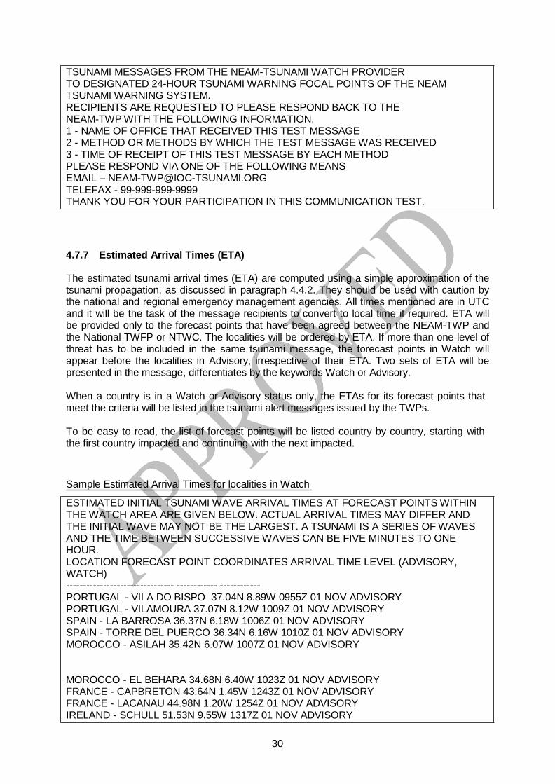
30
TSUNAMI MESSAGES FROM THE NEAM-TSUNAMI WATCH PROVIDER TO DESIGNATED 24-HOUR TSUNAMI WARNING FOCAL POINTS OF THE NEAM TSUNAMI WARNING SYSTEM. RECIPIENTS ARE REQUESTED TO PLEASE RESPOND BACK TO THE NEAM-TWP WITH THE FOLLOWING INFORMATION. 1 - NAME OF OFFICE THAT RECEIVED THIS TEST MESSAGE 2 - METHOD OR METHODS BY WHICH THE TEST MESSAGE WAS RECEIVED 3 - TIME OF RECEIPT OF THIS TEST MESSAGE BY EACH METHOD PLEASE RESPOND VIA ONE OF THE FOLLOWING MEANS EMAIL – [email protected] TELEFAX - 99-999-999-9999 THANK YOU FOR YOUR PARTICIPATION IN THIS COMMUNICATION TEST.
4.7.7 Estimated Arrival Times (ETA)
The estimated tsunami arrival times (ETA) are computed using a simple approximation of the tsunami propagation, as discussed in paragraph 4.4.2. They should be used with caution by the national and regional emergency management agencies. All times mentioned are in UTC and it will be the task of the message recipients to convert to local time if required. ETA will be provided only to the forecast points that have been agreed between the NEAM-TWP and the National TWFP or NTWC. The localities will be ordered by ETA. If more than one level of threat has to be included in the same tsunami message, the forecast points in Watch will appear before the localities in Advisory, irrespective of their ETA. Two sets of ETA will be presented in the message, differentiates by the keywords Watch or Advisory.
When a country is in a Watch or Advisory status only, the ETAs for its forecast points that meet the criteria will be listed in the tsunami alert messages issued by the TWPs.
To be easy to read, the list of forecast points will be listed country by country, starting with the first country impacted and continuing with the next impacted.
Sample Estimated Arrival Times for localities in Watch
ESTIMATED INITIAL TSUNAMI WAVE ARRIVAL TIMES AT FORECAST POINTS WITHIN THE WATCH AREA ARE GIVEN BELOW. ACTUAL ARRIVAL TIMES MAY DIFFER AND THE INITIAL WAVE MAY NOT BE THE LARGEST. A TSUNAMI IS A SERIES OF WAVES AND THE TIME BETWEEN SUCCESSIVE WAVES CAN BE FIVE MINUTES TO ONE HOUR. LOCATION FORECAST POINT COORDINATES ARRIVAL TIME LEVEL (ADVISORY, WATCH) -------------------------------- ------------ ------------ PORTUGAL - VILA DO BISPO 37.04N 8.89W 0955Z 01 NOV ADVISORY PORTUGAL - VILAMOURA 37.07N 8.12W 1009Z 01 NOV ADVISORY SPAIN - LA BARROSA 36.37N 6.18W 1006Z 01 NOV ADVISORY SPAIN - TORRE DEL PUERCO 36.34N 6.16W 1010Z 01 NOV ADVISORY MOROCCO - ASILAH 35.42N 6.07W 1007Z 01 NOV ADVISORY
MOROCCO - EL BEHARA 34.68N 6.40W 1023Z 01 NOV ADVISORY FRANCE - CAPBRETON 43.64N 1.45W 1243Z 01 NOV ADVISORY FRANCE - LACANAU 44.98N 1.20W 1254Z 01 NOV ADVISORY IRELAND - SCHULL 51.53N 9.55W 1317Z 01 NOV ADVISORY

31
IRELAND - TOP CROSS 51.83N 10.17W 1324Z 01 NOV ADVISORY UNITED KINGDOM - FALMOUTH 50.14N 5.07W 1417Z 01 NOV ADVISORY UNITED KINGDOM - MULLION 50.02N 5.26W 1424Z 01 NOV ADVISORY
4.7.8 Message Schedule (MS)
Near the end of the message appears a statement regarding future messages related to the same tsunami event. Supplemental messages will be issued according to new data and updated evaluation made at the NEAM-TWP. This field will apply both to Watch and Advisory levels of alert.
Samples of Schedule Statements
SUPPLEMENT MESSAGES WILL BE ISSUED AS SOON AS NEW DATA AND EVALUATION ALLOWS. THE TSUNAMI ALERT WILL REMAIN IN EFFECT UNTIL AN END OF ALERT IS BROADCAST.
THIS WILL BE THE FINAL MESSAGE ISSUED FOR THIS EVENT UNLESS ADDITIONAL INFORMATION BECOMES AVAILABLE.
4.7.9 Table of Message Content
The following table shows which of these elements normally appear in each type of a NEAM- TWP message.
Message Elements
Message Type Sequence MH MT+AA AS EP TM ES ETA MS Tsunami Watch
Initial Y Y 1,2,3 Y Y N Y Y Y
Supplement Y Y 1,2,3 Y Y O Y Y Y
End of Y Y 1,2,3 Y Y O Y O Y
Cancellation Y Y 1,2,3 Y Y O Y N Y Tsunami Advisory
Initial Y Y 2,3 Y Y N Y Y Y
Supplement Y Y 2,3 Y Y O Y Y Y
End of Y Y 2,3 Y Y O Y O Y
Cancellation Y Y 2,3 Y Y O Y N Y
Tsunami Information Single Y Y Y Y N Y N Y
Tsunami Communication Test Single Y Y N N N Y N N
Y = yes, N = no, O = optional MH - Message Header; MT+AA - Message Type and Affected Area; AS - Authority Statement; EP - Earthquake Parameters; TM - Tsunami Wave Measurements; ES - Evaluation Statement; ETA - Estimated Arrival Times; MS - Message Schedule.
The column MT+AA has 3 different contents:
- Tsunami Information and Tsunami Communication Test : 1 message title and 1 affected area (all countries)
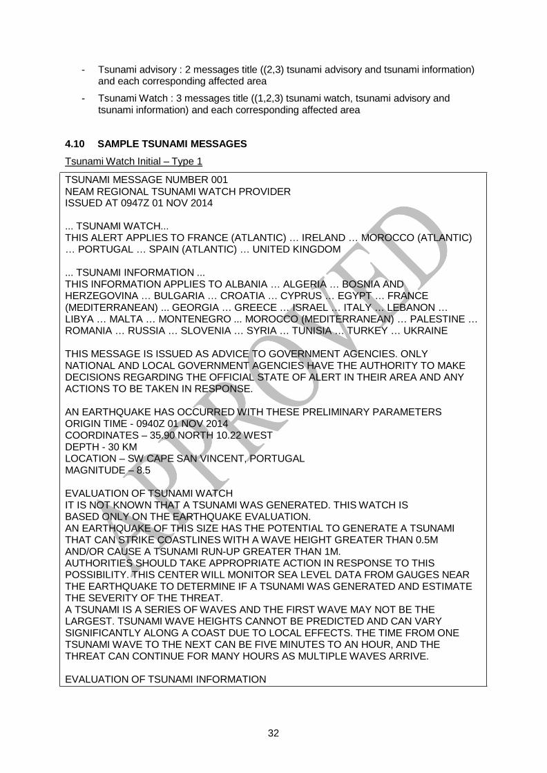
32
- Tsunami advisory : 2 messages title ((2,3) tsunami advisory and tsunami information) and each corresponding affected area
- Tsunami Watch : 3 messages title ((1,2,3) tsunami watch, tsunami advisory and tsunami information) and each corresponding affected area
4.10 SAMPLE TSUNAMI MESSAGES
Tsunami Watch Initial – Type 1
TSUNAMI MESSAGE NUMBER 001 NEAM REGIONAL TSUNAMI WATCH PROVIDER ISSUED AT 0947Z 01 NOV 2014
... TSUNAMI WATCH... THIS ALERT APPLIES TO FRANCE (ATLANTIC) … IRELAND … MOROCCO (ATLANTIC) … PORTUGAL … SPAIN (ATLANTIC) … UNITED KINGDOM
... TSUNAMI INFORMATION ... THIS INFORMATION APPLIES TO ALBANIA … ALGERIA … BOSNIA AND HERZEGOVINA … BULGARIA … CROATIA … CYPRUS … EGYPT … FRANCE (MEDITERRANEAN) ... GEORGIA … GREECE … ISRAEL … ITALY … LEBANON … LIBYA … MALTA … MONTENEGRO ... MOROCCO (MEDITERRANEAN) … PALESTINE … ROMANIA … RUSSIA … SLOVENIA … SYRIA … TUNISIA … TURKEY … UKRAINE
THIS MESSAGE IS ISSUED AS ADVICE TO GOVERNMENT AGENCIES. ONLY NATIONAL AND LOCAL GOVERNMENT AGENCIES HAVE THE AUTHORITY TO MAKE DECISIONS REGARDING THE OFFICIAL STATE OF ALERT IN THEIR AREA AND ANY ACTIONS TO BE TAKEN IN RESPONSE.
AN EARTHQUAKE HAS OCCURRED WITH THESE PRELIMINARY PARAMETERS ORIGIN TIME - 0940Z 01 NOV 2014 COORDINATES – 35.90 NORTH 10.22 WEST DEPTH - 30 KM LOCATION – SW CAPE SAN VINCENT, PORTUGAL MAGNITUDE – 8.5
EVALUATION OF TSUNAMI WATCH IT IS NOT KNOWN THAT A TSUNAMI WAS GENERATED. THIS WATCH IS BASED ONLY ON THE EARTHQUAKE EVALUATION. AN EARTHQUAKE OF THIS SIZE HAS THE POTENTIAL TO GENERATE A TSUNAMI THAT CAN STRIKE COASTLINES WITH A WAVE HEIGHT GREATER THAN 0.5M AND/OR CAUSE A TSUNAMI RUN-UP GREATER THAN 1M. AUTHORITIES SHOULD TAKE APPROPRIATE ACTION IN RESPONSE TO THIS POSSIBILITY. THIS CENTER WILL MONITOR SEA LEVEL DATA FROM GAUGES NEAR THE EARTHQUAKE TO DETERMINE IF A TSUNAMI WAS GENERATED AND ESTIMATE THE SEVERITY OF THE THREAT. A TSUNAMI IS A SERIES OF WAVES AND THE FIRST WAVE MAY NOT BE THE LARGEST. TSUNAMI WAVE HEIGHTS CANNOT BE PREDICTED AND CAN VARY SIGNIFICANTLY ALONG A COAST DUE TO LOCAL EFFECTS. THE TIME FROM ONE TSUNAMI WAVE TO THE NEXT CAN BE FIVE MINUTES TO AN HOUR, AND THE THREAT CAN CONTINUE FOR MANY HOURS AS MULTIPLE WAVES ARRIVE.
EVALUATION OF TSUNAMI INFORMATION

33
BASED ON HISTORICAL EARTHQUAKE AND TSUNAMI MODELLING THERE IS NO THREAT THAT A TSUNAMI HAS BEEN GENERATED THAT CAN CAUSE DAMAGE OR MAJOR EFFECT IN THE REGION. THIS MESSAGE IS FOR INFORMATION ONLY.
ESTIMATED INITIAL TSUNAMI WAVE ARRIVAL TIMES AT FORECAST POINTS WITHIN THE WATCH AREA ARE GIVEN BELOW. ACTUAL ARRIVAL TIMES MAY DIFFER AND THE INITIAL WAVE MAY NOT BE THE LARGEST. A TSUNAMI IS A SERIES OF WAVES AND THE TIME BETWEEN SUCCESSIVE WAVES CAN BE FIVE MINUTES TO ONE HOUR. LOCATION, FORECAST POINT COORDINATES, ARRIVAL TIME, ALERT LEVEL (ADVISORY, WATCH) -------------------------------- ------------ ------------ PORTUGAL - VILA DO BISPO 37.04N 8.89W 0955Z 01 NOV WATCH PORTUGAL - VILAMOURA 37.07N 8.12W 1009Z 01 NOV WATCH SPAIN - LA BARROSA 36.37N 6.18W 1006Z 01 NOV WATCH SPAIN - TORRE DEL PUERCO 36.34N 6.16W 1010Z 01 NOV WATCH MOROCCO - ASILAH 35.42N 6.07W 1007Z 01 NOV WATCH
MOROCCO - EL BEHARA 34.68N 6.40W 1023Z 01 NOV WATCH FRANCE - CAPBRETON 43.64N 1.45W 1243Z 01 NOV WATCH FRANCE - LACANAU 44.98N 1.20W 1254Z 01 NOV WATCH IRELAND - SCHULL 51.53N 9.55W 1317Z 01 NOV WATCH IRELAND - TOP CROSS 51.83N 10.17W 1324Z 01 NOV WATCH UNITED KINGDOM - FALMOUTH 50.14N 5.07W 1417Z 01 NOV WATCH UNITED KINGDOM - MULLION 50.02N 5.26W 1424Z 01 NOV WATCH
SUPPLEMENT MESSAGES WILL BE ISSUED AS SOON AS NEW DATA AND EVALUATION ALLOWS. THE TSUNAMI ALERT WILL REMAIN IN EFFECT UNTIL AN END OF ALERT IS BROADCAST.
Tsunami Watch Supplement Type 1
TSUNAMI MESSAGE NUMBER 002 NEAM TSUNAMI WATCH PROVIDER ISSUED AT 1017Z 01 NOV 2014
... TSUNAMI WATCH ONGOING ... THIS ALERT APPLIES TO FRANCE (ATLANTIC) … IRELAND … MOROCCO (ATLANTIC) … PORTUGAL … SPAIN (ATLANTIC) … UNITED KINGDOM
THIS MESSAGE IS ISSUED AS ADVICE TO GOVERNMENT AGENCIES. ONLY NATIONAL AND LOCAL GOVERNMENT AGENCIES HAVE THE AUTHORITY TO MAKE DECISIONS REGARDING THE OFFICIAL STATE OF ALERT IN THEIR AREA AND ANY ACTIONS TO BE TAKEN IN RESPONSE.
AN EARTHQUAKE HAS OCCURRED WITH THESE PRELIMINARY PARAMETERS ORIGIN TIME - 0940Z 01 NOV 2014 COORDINATES – 35.90 NORTH 10.22 WEST DEPTH - 30 KM LOCATION – SW CAPE SAN VINCENT, PORTUGAL MAGNITUDE – 8.5
EVALUATION OF TSUNAMI WATCH

34
SEA LEVEL READINGS INDICATE A TSUNAMI WAS GENERATED. THIS TSUNAMI CAN STRIKE COASTLINES WITH A WAVE HEIGHT GREATER THAN 0.5M AND/OR CAUSE A TSUNAMI RUN-UP GREATER THAN 1M. THIS CENTER WILL CONTINUE TO MONITOR SEA LEVEL GAUGES NEAREST THE REGION AND REPORT IF ANY ADDITIONAL TSUNAMI WAVE ACTIVITY IS OBSERVED. AUTHORITIES SHOULD TAKE APPROPRIATE ACTION IN RESPONSE TO THIS POSSIBILITY. A TSUNAMI IS A SERIES OF WAVES AND THE FIRST WAVE MAY NOT BE THE LARGEST. TSUNAMI WAVE HEIGHTS CANNOT BE PREDICTED AND CAN VARY SIGNIFICANTLY ALONG A COAST DUE TO LOCAL EFFECTS. THE TIME FROM ONE TSUNAMI WAVE TO THE NEXT CAN BE FIVE MINUTES TO AN HOUR, AND THE THREAT CAN CONTINUE FOR MANY HOURS AS MULTIPLE WAVES ARRIVE.
ESTIMATED INITIAL TSUNAMI WAVE ARRIVAL TIMES AT FORECAST POINTS WITHIN THE WATCH AREA ARE GIVEN BELOW. ACTUAL ARRIVAL TIMES MAY DIFFER AND THE INITIAL WAVE MAY NOT BE THE LARGEST. A TSUNAMI IS A SERIES OF WAVES AND THE TIME BETWEEN SUCCESSIVE WAVES CAN BE FIVE MINUTES TO ONE HOUR. LOCATION, FORECAST POINT COORDINATES, ARRIVAL TIME, ALERT LEVEL (ADVISORY, WATCH)
-------------------------------- ------------ ------------ PORTUGAL - VILA DO BISPO 37.04N 8.89W 0955Z 01 NOV WATCH PORTUGAL - VILAMOURA 37.07N 8.12W 1009Z 01 NOV WATCH SPAIN - LA BARROSA 36.37N 6.18W 1006Z 01 NOV WATCH SPAIN - TORRE DEL PUERCO 36.34N 6.16W 1010Z 01 NOV WATCH MOROCCO - ASILAH 35.42N 6.07W 1007Z 01 NOV WATCH
MOROCCO - EL BEHARA 34.68N 6.40W 1023Z 01 NOV WATCH FRANCE - CAPBRETON 43.64N 1.45W 1243Z 01 NOV WATCH FRANCE - LACANAU 44.98N 1.20W 1254Z 01 NOV WATCH IRELAND - SCHULL 51.53N 9.55W 1317Z 01 NOV WATCH IRELAND - TOP CROSS 51.83N 10.17W 1324Z 01 NOV WATCH UNITED KINGDOM - FALMOUTH 50.14N 5.07W 1417Z 01 NOV WATCH UNITED KINGDOM - MULLION 50.02N 5.26W 1424Z 01 NOV WATCH
MEASUREMENTS OR REPORTS OF TSUNAMI WAVE ACTIVITY GAUGE LOCATION LAT LON TIME AMPL PER ------------------- ----- ------ ----- --------------- ----- PORTUGAL - LAGOS 37.06N 8.73W 1003Z 2.44M 12MIN PORTUGAL - SINES 37.97N 8.89W 1007Z 2.25M 7MIN LAT - LATITUDE (N-NORTH, S-SOUTH) LON - LONGITUDE (E-EAST, W-WEST) TIME - TIME OF THE MEASUREMENT (Z IS UTC TIME) AMPL - TSUNAMI AMPLITUDE MEASURED RELATIVE TO NORMAL SEA LEVEL. IT IS ...NOT... CREST-TO-TROUGH WAVE HEIGHT. VALUES ARE GIVEN IN METERS (M). PER - PERIOD OF TIME IN MINUTES (MIN) FROM ONE WAVE TO THE NEXT.
SUPPLEMENT MESSAGES WILL BE ISSUED AS SOON AS NEW DATA AND EVALUATION ALLOWS. THE TSUNAMI ALERT WILL REMAIN IN EFFECT UNTIL AN END OF ALERT IS BROADCAST.

35
End of Tsunami Watch Type 1
TSUNAMI MESSAGE NUMBER 003 NEAM TSUNAMI WATCH PROVIDER ISSUED AT 1625Z 01 NOV 2014
... END OF TSUNAMI WATCH ... THIS ALERT APPLIES TO FRANCE (ATLANTIC) … IRELAND … MOROCCO (ATLANTIC) … PORTUGAL … SPAIN (ATLANTIC) … UNITED KINGDOM
THIS MESSAGE IS ISSUED AS ADVICE TO GOVERNMENT AGENCIES. ONLY NATIONAL AND LOCAL GOVERNMENT AGENCIES HAVE THE AUTHORITY TO MAKE DECISIONS REGARDING THE OFFICIAL STATE OF ALERT IN THEIR AREA AND ANY ACTIONS TO BE TAKEN IN RESPONSE.
AN EARTHQUAKE HAS OCCURRED WITH THESE PRELIMINARY PARAMETERS ORIGIN TIME - 0940Z 01 NOV 2014 COORDINATES – 35.90 NORTH 10.22 WEST DEPTH - 30 KM LOCATION – SW CAPE SAN VINCENT, PORTUGAL MAGNITUDE – 8.5
EVALUATION OF TSUNAMI WATCH SEA LEVEL READINGS INDICATE A TSUNAMI WAS GENERATED. OBSERVATIONS AND MODELS INDICATE THAT NO MORE TSUNAMI WAVES ARE EXPECTED.
WHEN NO MAJOR WAVES ARE OBSERVED FOR TWO HOURS AFTER THE ESTIMATED TIME OF ARRIVAL OR DAMAGING WAVES HAVE NOT OCCURRED FOR AT LEAST TWO HOURS THEN LOCAL AUTHORITIES CAN ASSUME THE THREAT IS PASSED. DANGER TO BOATS AND COASTAL STRUCTURES CAN CONTINUE FOR SEVERAL HOURS DUE TO THE CONTINUING SEA LEVEL CHANGES AND RAPID CURRENTS. AS LOCAL CONDITIONS CAN CAUSE A WIDE VARIATION IN TSUNAMI WAVE ACTION THE ALL CLEAR DETERMINATION MUST BE MADE BY LOCAL AUTHORITIES.
THIS WILL BE THE FINAL MESSAGE ISSUED FOR THIS EVENT UNLESS ADDITIONAL INFORMATION BECOMES AVAILABLE.
Tsunami Watch Cancellation Type 1
TSUNAMI MESSAGE NUMBER 002 NEAM TSUNAMI WATCH PROVIDER ISSUED AT 1020Z 01 NOV 2014
... TSUNAMI WATCH CANCELLATION ... THIS ALERT APPLIES TO FRANCE (ATLANTIC) … IRELAND … MOROCCO (ATLANTIC) … PORTUGAL … SPAIN (ATLANTIC) … UNITED KINGDOM
THIS MESSAGE IS ISSUED AS ADVICE TO GOVERNMENT AGENCIES. ONLY NATIONAL AND LOCAL GOVERNMENT AGENCIES HAVE THE AUTHORITY TO MAKE DECISIONS REGARDING THE OFFICIAL STATE OF ALERT IN THEIR AREA AND ANY ACTIONS TO BE TAKEN IN RESPONSE.
AN EARTHQUAKE HAS OCCURRED WITH THESE PRELIMINARY PARAMETERS
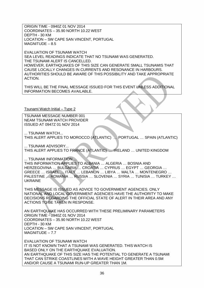
36
ORIGIN TIME - 0940Z 01 NOV 2014 COORDINATES – 35.90 NORTH 10.22 WEST DEPTH - 30 KM LOCATION – SW CAPE SAN VINCENT, PORTUGAL MAGNITUDE – 8.5
EVALUATION OF TSUNAMI WATCH SEA LEVEL READINGS INDICATE THAT NO TSUNAMI WAS GENERATED. THE TSUNAMI ALERT IS CANCELLED. HOWEVER, EARTHQUAKES OF THIS SIZE CAN GENERATE SMALL TSUNAMIS THAT CAUSE LOCALLY CHANGES IN CURRENTS AND RESONANCE IN HARBOURS. AUTHORITIES SHOULD BE AWARE OF THIS POSSIBILITY AND TAKE APPROPRIATE ACTION.
THIS WILL BE THE FINAL MESSAGE ISSUED FOR THIS EVENT UNLESS ADDITIONAL INFORMATION BECOMES AVAILABLE.
Tsunami Watch Initial – Type 2
TSUNAMI MESSAGE NUMBER 001 NEAM TSUNAMI WATCH PROVIDER ISSUED AT 0947Z 01 NOV 2014
... TSUNAMI WATCH... THIS ALERT APPLIES TO MOROCCO (ATLANTIC) … PORTUGAL … SPAIN (ATLANTIC)
... TSUNAMI ADVISORY... THIS ALERT APPLIES TO FRANCE (ATLANTIC) … IRELAND … UNITED KINGDOM
... TSUNAMI INFORMATION ... THIS INFORMATION APPLIES TO ALBANIA … ALGERIA … BOSNIA AND HERZEGOVINA … BULGARIA … CROATIA … CYPRUS … EGYPT … GEORGIA … GREECE … ISRAEL … ITALY … LEBANON … LIBYA … MALTA … MONTENEGRO … PALESTINE … ROMANIA … RUSSIA … SLOVENIA … SYRIA … TUNISIA … TURKEY … UKRAINE
THIS MESSAGE IS ISSUED AS ADVICE TO GOVERNMENT AGENCIES. ONLY NATIONAL AND LOCAL GOVERNMENT AGENCIES HAVE THE AUTHORITY TO MAKE DECISIONS REGARDING THE OFFICIAL STATE OF ALERT IN THEIR AREA AND ANY ACTIONS TO BE TAKEN IN RESPONSE.
AN EARTHQUAKE HAS OCCURRED WITH THESE PRELIMINARY PARAMETERS ORIGIN TIME - 0940Z 01 NOV 2014 COORDINATES – 35.90 NORTH 10.22 WEST DEPTH - 30 KM LOCATION – SW CAPE SAN VINCENT, PORTUGAL MAGNITUDE – 7.7
EVALUATION OF TSUNAMI WATCH IT IS NOT KNOWN THAT A TSUNAMI WAS GENERATED. THIS WATCH IS BASED ONLY ON THE EARTHQUAKE EVALUATION. AN EARTHQUAKE OF THIS SIZE HAS THE POTENTIAL TO GENERATE A TSUNAMI THAT CAN STRIKE COASTLINES WITH A WAVE HEIGHT GREATER THAN 0.5M AND/OR CAUSE A TSUNAMI RUN-UP GREATER THAN 1M.

37
AUTHORITIES SHOULD TAKE APPROPRIATE ACTION IN RESPONSE TO THIS POSSIBILITY. THIS CENTER WILL MONITOR SEA LEVEL DATA FROM GAUGES NEAR THE EARTHQUAKE TO DETERMINE IF A TSUNAMI WAS GENERATED AND ESTIMATE THE SEVERITY OF THE THREAT. A TSUNAMI IS A SERIES OF WAVES AND THE FIRST WAVE MAY NOT BE THE LARGEST. TSUNAMI WAVE HEIGHTS CANNOT BE PREDICTED AND CAN VARY SIGNIFICANTLY ALONG A COAST DUE TO LOCAL EFFECTS. THE TIME FROM ONE TSUNAMI WAVE TO THE NEXT CAN BE FIVE MINUTES TO AN HOUR, AND THE THREAT CAN CONTINUE FOR MANY HOURS AS MULTIPLE WAVES ARRIVE.
EVALUATION OF TSUNAMI ADVISORY AN EARTHQUAKE OF THIS SIZE HAS THE POTENTIAL TO GENERATE A TSUNAMI THAT CAN STRIKE COASTLINES WITH A WAVE HEIGHT LESS THAN 0.5M AND/OR CAUSE A TSUNAMI RUN-UP LESS THAN 1M , AT MORE THAN 1000 KM FAR FROM THE EPICENTER
EVALUATION OF TSUNAMI INFORMATION BASED ON HISTORICAL EARTHQUAKE AND TSUNAMI MODELLING THERE IS NO THREAT THAT A TSUNAMI HAS BEEN GENERATED THAT CAN CAUSE DAMAGE OR MAJOR EFFECT IN THE REGION. THIS MESSAGE IS FOR INFORMATION ONLY.
ESTIMATED INITIAL TSUNAMI WAVE ARRIVAL TIMES AT FORECAST POINTS WITHIN THE WATCH AREA ARE GIVEN BELOW. ACTUAL ARRIVAL TIMES MAY DIFFER AND THE INITIAL WAVE MAY NOT BE THE LARGEST. A TSUNAMI IS A SERIES OF WAVES AND THE TIME BETWEEN SUCCESSIVE WAVES CAN BE FIVE MINUTES TO ONE HOUR. LOCATION , FORECAST POINT COORDINATES, ARRIVAL TIME, ALERT LEVEL (ADVISORY, WATCH) -------------------------------- ------------ ------------ PORTUGAL - VILA DO BISPO 37.04N 8.89W 0955Z 01 NOV WATCH PORTUGAL - VILAMOURA 37.07N 8.12W 1009Z 01 NOV WATCH SPAIN - LA BARROSA 36.37N 6.18W 1006Z 01 NOV WATCH SPAIN - TORRE DEL PUERCO 36.34N 6.16W 1010Z 01 NOV WATCH MOROCCO - ASILAH 35.42N 6.07W 1007Z 01 NOV WATCH
MOROCCO - EL BEHARA 34.68N 6.40W 1023Z 01 NOV WATCH FRANCE - CAPBRETON 43.64N 1.45W 1243Z 01 NOV ADVISORY FRANCE - LACANAU 44.98N 1.20W 1254Z 01 NOV ADVISORY IRELAND - SCHULL 51.53N 9.55W 1317Z 01 NOV ADVISORY IRELAND - TOP CROSS 51.83N 10.17W 1324Z 01 NOV ADVISORY UNITED KINGDOM - FALMOUTH 50.14N 5.07W 1417Z 01 NOV ADVISORY UNITED KINGDOM - MULLION 50.02N 5.26W 1424Z 01 NOV ADVISORY
SUPPLEMENT MESSAGES WILL BE ISSUED AS SOON AS NEW DATA AND EVALUATION ALLOWS. THE TSUNAMI ALERT WILL REMAIN IN EFFECT UNTIL AN END OF ALERT IS BROADCAST.
Tsunami Watch Supplement Type 22
TSUNAMI MESSAGE NUMBER 002 NEAM TSUNAMI WATCH PROVIDER
2 Note by F. Schindelé. Italics in the message text indicate repetitions that we should try to avoid.

38
ISSUED AT 1017Z 01 NOV 2014
... TSUNAMI WATCH ONGOING ... THIS ALERT APPLIES TO MOROCCO (ATLANTIC) … PORTUGAL … SPAIN (ATLANTIC)
... TSUNAMI ADVISORY ONGOING... THIS ALERT APPLIES TO FRANCE (ATLANTIC) … IRELAND … UNITED KINGDOM
THIS MESSAGE IS ISSUED AS ADVICE TO GOVERNMENT AGENCIES. ONLY NATIONAL AND LOCAL GOVERNMENT AGENCIES HAVE THE AUTHORITY TO MAKE DECISIONS REGARDING THE OFFICIAL STATE OF ALERT IN THEIR AREA AND ANY ACTIONS TO BE TAKEN IN RESPONSE.
AN EARTHQUAKE HAS OCCURRED WITH THESE PRELIMINARY PARAMETERS ORIGIN TIME - 0940Z 01 NOV 2014 COORDINATES – 35.90 NORTH 10.22 WEST DEPTH - 30 KM LOCATION – SW CAPE SAN VINCENT, PORTUGAL MAGNITUDE – 7.7
EVALUATION OF TSUNAMI WATCH SEA LEVEL READINGS INDICATE A TSUNAMI WAS GENERATED. THIS TSUNAMI CAN STRIKE COASTLINES WITH A WAVE HEIGHT GREATER THAN 0.5M AND/OR CAUSE A TSUNAMI RUN-UP GREATER THAN 1M. THIS CENTER WILL CONTINUE TO MONITOR SEA LEVEL GAUGES NEAREST THE REGION AND REPORT IF ANY ADDITIONAL TSUNAMI WAVE ACTIVITY IS OBSERVED. AUTHORITIES SHOULD TAKE APPROPRIATE ACTION IN RESPONSE TO THIS POSSIBILITY. A TSUNAMI IS A SERIES OF WAVES AND THE FIRST WAVE MAY NOT BE THE LARGEST. TSUNAMI WAVE HEIGHTS CANNOT BE PREDICTED AND CAN VARY SIGNIFICANTLY ALONG A COAST DUE TO LOCAL EFFECTS. THE TIME FROM ONE TSUNAMI WAVE TO THE NEXT CAN BE FIVE MINUTES TO AN HOUR, AND THE THREAT CAN CONTINUE FOR MANY HOURS AS MULTIPLE WAVES ARRIVE.
EVALUATION OF TSUNAMI ADVISORY THIS TSUNAMI CAN STRIKE COASTLINES WITH A WAVE HEIGHT LESS THAN 0.5M AND/OR CAUSE A TSUNAMI RUN-UP LESS THAN 1M., AT MORE THAN 1000 KM FAR FROM THE EPICENTER AUTHORITIES SHOULD TAKE APPROPRIATE ACTION IN RESPONSE TO THIS POSSIBILITY.
ESTIMATED INITIAL TSUNAMI WAVE ARRIVAL TIMES AT FORECAST POINTS WITHIN THE WATCH AREA ARE GIVEN BELOW. ACTUAL ARRIVAL TIMES MAY DIFFER AND THE INITIAL WAVE MAY NOT BE THE LARGEST. A TSUNAMI IS A SERIES OF WAVES AND THE TIME BETWEEN SUCCESSIVE WAVES CAN BE FIVE MINUTES TO ONE HOUR. LOCATION, FORECAST POINT COORDINATES, ARRIVAL TIME, ALERT LEVEL (ADVISORY, WATCH)
-------------------------------- ------------ ------------ PORTUGAL - VILA DO BISPO 37.04N 8.89W 0955Z 01 NOV WATCH PORTUGAL - VILAMOURA 37.07N 8.12W 1009Z 01 NOV WATCH SPAIN - LA BARROSA 36.37N 6.18W 1006Z 01 NOV WATCH SPAIN - TORRE DEL PUERCO 36.34N 6.16W 1010Z 01 NOV WATCH MOROCCO - ASILAH 35.42N 6.07W 1007Z 01 NOV WATCH

39
MOROCCO - EL BEHARA 34.68N 6.40W 1023Z 01 NOV W FRANCE - CAPBRETON 43.64N 1.45W 1243Z 01 NOV ADVISORY FRANCE - LACANAU 44.98N 1.20W 1254Z 01 NOV ADVISORY IRELAND - SCHULL 51.53N 9.55W 1317Z 01 NOV ADVISORY IRELAND - TOP CROSS 51.83N 10.17W 1324Z 01 NOV ADVISORY UNITED KINGDOM - FALMOUTH 50.14N 5.07W 1417Z 01 NOV ADVISORY UNITED KINGDOM - MULLION 50.02N 5.26W 1424Z 01 NOV ADVISORY
MEASUREMENTS OR REPORTS OF TSUNAMI WAVE ACTIVITY GAUGE LOCATION LAT LON TIME AMPL PER ------------------- ----- ------ ----- --------------- ----- PORTUGAL - LAGOS 37.06N 8.73W 1003Z 0.94M 12MIN PORTUGAL - SINES 37.97N 8.89W 1007Z 1.05M 7MIN LAT - LATITUDE (N-NORTH, S-SOUTH) LON - LONGITUDE (E-EAST, W-WEST) TIME - TIME OF THE MEASUREMENT (Z IS UTC TIME) AMPL - TSUNAMI AMPLITUDE MEASURED RELATIVE TO NORMAL SEA LEVEL. IT IS ...NOT... CREST-TO-TROUGH WAVE HEIGHT. VALUES ARE GIVEN IN METERS (M). PER - PERIOD OF TIME IN MINUTES (MIN) FROM ONE WAVE TO THE NEXT.
SUPPLEMENT MESSAGES WILL BE ISSUED AS SOON AS NEW DATA AND EVALUATION ALLOWS. THE TSUNAMI ALERT WILL REMAIN IN EFFECT UNTIL AN END OF ALERT IS BROADCAST.
End of Tsunami Watch Type 2
TSUNAMI MESSAGE NUMBER 003 NEAM TSUNAMI WATCH PROVIDER ISSUED AT 1625Z 01 NOV 2014
... END OF TSUNAMI WATCH ... THIS ALERT APPLIES TO MOROCCO (ATLANTIC) … PORTUGAL … SPAIN (ATLANTIC)
... END OF TSUNAMI ADVISORY ... THIS ALERT APPLIES TO FRANCE (ATLANTIC) … IRELAND …UNITED KINGDOM
THIS MESSAGE IS ISSUED AS ADVICE TO GOVERNMENT AGENCIES. ONLY NATIONAL AND LOCAL GOVERNMENT AGENCIES HAVE THE AUTHORITY TO MAKE DECISIONS REGARDING THE OFFICIAL STATE OF ALERT IN THEIR AREA AND ANY ACTIONS TO BE TAKEN IN RESPONSE.
AN EARTHQUAKE HAS OCCURRED WITH THESE PRELIMINARY PARAMETERS ORIGIN TIME - 0940Z 01 NOV 2014 COORDINATES – 35.90 NORTH 10.22 WEST DEPTH - 30 KM LOCATION – SW CAPE SAN VINCENT, PORTUGAL MAGNITUDE – 7.7
EVALUATION OF TSUNAMI WATCH SEA LEVEL READINGS INDICATE A TSUNAMI WAS GENERATED. OBSERVATIONS AND MODELS INDICATE THAT NO MORE TSUNAMI WAVES ARE EXPECTED.

40
EVALUATION OF TSUNAMI ADVISORY THIS TSUNAMI CAN STRIKE COASTLINES WITH A WAVE HEIGHT LESS THAN 0.5M AND/OR CAUSE A TSUNAMI RUN-UP LESS THAN 1M, AT MORE THAN 1000 KM FAR FROM THE EPICENTER. AUTHORITIES SHOULD TAKE APPROPRIATE ACTION IN RESPONSE TO THIS POSSIBILITY.
WHEN NO MAJOR WAVES ARE OBSERVED FOR TWO HOURS AFTER THE ESTIMATED TIME OF ARRIVAL OR DAMAGING WAVES HAVE NOT OCCURRED FOR AT LEAST TWO HOURS THEN LOCAL AUTHORITIES CAN ASSUME THE THREAT IS PASSED. DANGER TO BOATS AND COASTAL STRUCTURES CAN CONTINUE FOR SEVERAL HOURS DUE TO THE CONTINUING SEA LEVEL CHANGES AND RAPID CURRENTS. AS LOCAL CONDITIONS CAN CAUSE A WIDE VARIATION IN TSUNAMI WAVE ACTION THE ALL CLEAR DETERMINATION MUST BE MADE BY LOCAL AUTHORITIES.
THIS WILL BE THE FINAL MESSAGE ISSUED FOR THIS EVENT UNLESS ADDITIONAL INFORMATION BECOMES AVAILABLE.
Tsunami Watch Cancellation Type 2
TSUNAMI MESSAGE NUMBER 002 NEAM TSUNAMI WATCH PROVIDER ISSUED AT 1020Z 01 NOV 2014
... TSUNAMI WATCH CANCELLATION ... THIS ALERT APPLIES TO MOROCCO (ATLANTIC) … PORTUGAL … SPAIN (ATLANTIC)
... TSUNAMI ADVISORY CANCELLATION ... THIS ALERT APPLIES TO FRANCE (ATLANTIC) … IRELAND …UNITED KINGDOM
THIS MESSAGE IS ISSUED AS ADVICE TO GOVERNMENT AGENCIES. ONLY NATIONAL AND LOCAL GOVERNMENT AGENCIES HAVE THE AUTHORITY TO MAKE DECISIONS REGARDING THE OFFICIAL STATE OF ALERT IN THEIR AREA AND ANY ACTIONS TO BE TAKEN IN RESPONSE.
AN EARTHQUAKE HAS OCCURRED WITH THESE PRELIMINARY PARAMETERS ORIGIN TIME - 0940Z 01 NOV 2014 COORDINATES – 35.90 NORTH 10.22 WEST DEPTH - 30 KM LOCATION – SW CAPE SAN VINCENT, PORTUGAL MAGNITUDE – 7.7
EVALUATION OF TSUNAMI WATCH AND ADVISORY SEA LEVEL READINGS INDICATE THAT NO TSUNAMI WAS GENERATED. THE TSUNAMI ALERT IS CANCELLED. HOWEVER, EARTHQUAKES OF THIS SIZE CAN GENERATE SMALL TSUNAMIS THAT CAUSE LOCALLY CHANGES IN CURRENTS AND RESONANCE IN HARBOURS. AUTHORITIES SHOULD BE AWARE OF THIS POSSIBILITY AND TAKE APPROPRIATE ACTION.

41
THIS WILL BE THE FINAL MESSAGE ISSUED FOR THIS EVENT UNLESS ADDITIONAL INFORMATION BECOMES AVAILABLE.
Tsunami Advisory Initial
TSUNAMI MESSAGE NUMBER 001 NEAM TSUNAMI WATCH PROVIDER ISSUED AT 0947Z 01 NOV 2014
... TSUNAMI ADVISORY... THIS ALERT APPLIES TO IRELAND … MOROCCO (ATLANTIC) … PORTUGAL … SPAIN (ATLANTIC) …
... TSUNAMI INFORMATION ... THIS INFORMATION APPLIES TO ALBANIA … ALGERIA … BOSNIA AND HERZEGOVINA … BULGARIA … CROATIA … CYPRUS … EGYPT … FRANCE … GEORGIA … GREECE … ISRAEL … ITALY … IRELAND … LEBANON … LIBYA … MALTA … MONTENEGRO … PALESTINE … ROMANIA … RUSSIA … SLOVENIA … SYRIA … TUNISIA … TURKEY … UKRAINE … UNITED KINGDOM
THIS MESSAGE IS ISSUED AS ADVICE TO GOVERNMENT AGENCIES. ONLY NATIONAL AND LOCAL GOVERNMENT AGENCIES HAVE THE AUTHORITY TO MAKE DECISIONS REGARDING THE OFFICIAL STATE OF ALERT IN THEIR AREA AND ANY ACTIONS TO BE TAKEN IN RESPONSE.
AN EARTHQUAKE HAS OCCURRED WITH THESE PRELIMINARY PARAMETERS ORIGIN TIME - 0940Z 01 NOV 2014 COORDINATES – 35.90 NORTH 10.22 WEST DEPTH - 30 KM LOCATION – SW CAPE SAN VINCENT, PORTUGAL MAGNITUDE – 7.2
EVALUATION OF TSUNAMI ADVISORY IT IS NOT KNOWN THAT A TSUNAMI WAS GENERATED. THIS WATCH IS BASED ONLY ON THE EARTHQUAKE EVALUATION. AN EARTHQUAKE OF THIS SIZE HAS THE POTENTIAL TO GENERATE A TSUNAMI THAT CAN STRIKE COASTLINES WITH A WAVE HEIGHT LESS THAN 0.5M AND/OR CAUSE A TSUNAMI RUN-UP LESS THAN 1M. AUTHORITIES SHOULD TAKE APPROPRIATE ACTION IN RESPONSE TO THIS POSSIBILITY. THIS CENTER WILL MONITOR SEA LEVEL DATA FROM GAUGES NEAR THE EARTHQUAKE TO DETERMINE IF A TSUNAMI WAS GENERATED AND ESTIMATE THE SEVERITY OF THE THREAT. A TSUNAMI IS A SERIES OF WAVES AND THE FIRST WAVE MAY NOT BE THE LARGEST. TSUNAMI WAVE HEIGHTS CANNOT BE PREDICTED AND CAN VARY SIGNIFICANTLY ALONG A COAST DUE TO LOCAL EFFECTS. THE TIME FROM ONE TSUNAMI WAVE TO THE NEXT CAN BE FIVE MINUTES TO AN HOUR, AND THE THREAT CAN CONTINUE FOR MANY HOURS AS MULTIPLE WAVES ARRIVE.
EVALUATION OF TSUNAMI INFORMATION BASED ON HISTORICAL EARTHQUAKE AND TSUNAMI MODELLING THERE IS NO THREAT THAT A TSUNAMI HAS BEEN GENERATED THAT CAN CAUSE DAMAGE OR MAJOR EFFECT IN THE REGION. THIS MESSAGE IS FOR INFORMATION ONLY.
ESTIMATED INITIAL TSUNAMI WAVE ARRIVAL TIMES AT FORECAST POINTS WITHIN THE WATCH AREA ARE GIVEN BELOW. ACTUAL ARRIVAL TIMES MAY DIFFER AND

42
THE INITIAL WAVE MAY NOT BE THE LARGEST. A TSUNAMI IS A SERIES OF WAVES AND THE TIME BETWEEN SUCCESSIVE WAVES CAN BE FIVE MINUTES TO ONE HOUR. LOCATION, FORECAST POINT COORDINATES, ARRIVAL TIME, ALERT LEVEL (ADVISORY, WATCH) -------------------------------- ------------ ------------ PORTUGAL - VILA DO BISPO 37.04N 8.89W 0955Z 01 NOV ADVISORY PORTUGAL - VILAMOURA 37.07N 8.12W 1009Z 01 NOV ADVISORY SPAIN - LA BARROSA 36.37N 6.18W 1006Z 01 NOV ADVISORY SPAIN - TORRE DEL PUERCO 36.34N 6.16W 1010Z 01 NOV ADVISORY MOROCCO - ASILAH 35.42N 6.07W 1007Z 01 NOV ADVISORY
MOROCCO - EL BEHARA 34.68N 6.40W 1023Z 01 NOV ADVISORY FRANCE - CAPBRETON 43.64N 1.45W 1243Z 01 NOV ADVISORY FRANCE - LACANAU 44.98N 1.20W 1254Z 01 NOV ADVISORY IRELAND - SCHULL 51.53N 9.55W 1317Z 01 NOV ADVISORY IRELAND - TOP CROSS 51.83N 10.17W 1324Z 01 NOV ADVISORY UNITED KINGDOM - FALMOUTH 50.14N 5.07W 1417Z 01 NOV ADVISORY UNITED KINGDOM - MULLION 50.02N 5.26W 1424Z 01 NOV ADVISORY
SUPPLEMENT MESSAGES WILL BE ISSUED AS SOON AS NEW DATA AND EVALUATION ALLOWS. THE TSUNAMI ALERT WILL REMAIN IN EFFECT UNTIL AN END OF ALERT IS BROADCAST.
Tsunami Advisory Supplement
TSUNAMI MESSAGE NUMBER 002 NEAM TSUNAMI WATCH PROVIDER ISSUED AT 1017Z 01 NOV 2014
... TSUNAMI ADVISORY ONGOING ... THIS ALERT APPLIES TO IRELAND … MOROCCO (ATLANTIC) … PORTUGAL … SPAIN (ATLANTIC) … THIS MESSAGE IS ISSUED AS ADVICE TO GOVERNMENT AGENCIES. ONLY NATIONAL AND LOCAL GOVERNMENT AGENCIES HAVE THE AUTHORITY TO MAKE DECISIONS REGARDING THE OFFICIAL STATE OF ALERT IN THEIR AREA AND ANY ACTIONS TO BE TAKEN IN RESPONSE.
AN EARTHQUAKE HAS OCCURRED WITH THESE PRELIMINARY PARAMETERS ORIGIN TIME - 0940Z 01 NOV 2014 COORDINATES – 35.90 NORTH 10.22 WEST DEPTH - 30 KM LOCATION – SW CAPE SAN VINCENT, PORTUGAL MAGNITUDE – 7.2
EVALUATION OF TSUNAMI ADVISORY SEA LEVEL READINGS INDICATE A TSUNAMI WAS GENERATED. THIS TSUNAMI CAN STRIKE COASTLINES WITH A WAVE HEIGHT LESS THAN 0.5M AND/OR CAUSE A TSUNAMI RUN-UP LESS THAN 1M. THIS CENTER WILL CONTINUE TO MONITOR SEA LEVEL GAUGES NEAREST THE REGION AND REPORT IF ANY ADDITIONAL TSUNAMI WAVE ACTIVITY IS OBSERVED. AUTHORITIES SHOULD TAKE APPROPRIATE ACTION IN RESPONSE TO THIS POSSIBILITY.

43
A TSUNAMI IS A SERIES OF WAVES AND THE FIRST WAVE MAY NOT BE THE LARGEST. TSUNAMI WAVE HEIGHTS CANNOT BE PREDICTED AND CAN VARY SIGNIFICANTLY ALONG A COAST DUE TO LOCAL EFFECTS. THE TIME FROM ONE TSUNAMI WAVE TO THE NEXT CAN BE FIVE MINUTES TO AN HOUR, AND THE THREAT CAN CONTINUE FOR MANY HOURS AS MULTIPLE WAVES ARRIVE.
ESTIMATED INITIAL TSUNAMI WAVE ARRIVAL TIMES AT FORECAST POINTS WITHIN THE WATCH AREA ARE GIVEN BELOW. ACTUAL ARRIVAL TIMES MAY DIFFER AND THE INITIAL WAVE MAY NOT BE THE LARGEST. A TSUNAMI IS A SERIES OF WAVES AND THE TIME BETWEEN SUCCESSIVE WAVES CAN BE FIVE MINUTES TO ONE HOUR. LOCATION, FORECAST POINT COORDINATES, ARRIVAL TIME, ALERT LEVEL (ADVISORY, WATCH) -------------------------------- ------------ ------------ PORTUGAL - VILA DO BISPO 37.04N 8.89W 0955Z 01 NOV ADVISORY PORTUGAL - VILAMOURA 37.07N 8.12W 1009Z 01 NOV ADVISORY SPAIN - LA BARROSA 36.37N 6.18W 1006Z 01 NOV ADVISORY SPAIN - TORRE DEL PUERCO 36.34N 6.16W 1010Z 01 NOV ADVISORY MOROCCO - ASILAH 35.42N 6.07W 1007Z 01 NOV ADVISORY MOROCCO - EL BEHARA 34.68N 6.40W 1023Z 01 NOV ADVISORY FRANCE - CAPBRETON 43.64N 1.45W 1243Z 01 NOV ADVISORY FRANCE - LACANAU 44.98N 1.20W 1254Z 01 NOV ADVISORY IRELAND - SCHULL 51.53N 9.55W 1317Z 01 NOV ADVISORY IRELAND - TOP CROSS 51.83N 10.17W 1324Z 01 NOV ADVISORY UNITED KINGDOM - FALMOUTH 50.14N 5.07W 1417Z 01 NOV ADVISORY UNITED KINGDOM - MULLION 50.02N 5.26W 1424Z 01 NOV ADVISORY
MEASUREMENTS OR REPORTS OF TSUNAMI WAVE ACTIVITY GAUGE LOCATION LAT LON TIME AMPL PER ------------------- ----- ------ ----- --------------- ----- PORTUGAL - LAGOS 37.06N 8.73W 1003Z 0.54M 12MIN PORTUGAL - SINES 37.97N 8.89W 1007Z 0.35M 7MIN LAT - LATITUDE (N-NORTH, S-SOUTH) LON - LONGITUDE (E-EAST, W-WEST) TIME - TIME OF THE MEASUREMENT (Z IS UTC TIME) AMPL - TSUNAMI AMPLITUDE MEASURED RELATIVE TO NORMAL SEA LEVEL. IT IS ...NOT... CREST-TO-TROUGH WAVE HEIGHT. VALUES ARE GIVEN IN METERS (M). PER - PERIOD OF TIME IN MINUTES (MIN) FROM ONE WAVE TO THE NEXT.
SUPPLEMENT MESSAGES WILL BE ISSUED AS SOON AS NEW DATA AND EVALUATION ALLOWS. THE TSUNAMI ALERT WILL REMAIN IN EFFECT UNTIL AN END OF ALERT IS BROADCAST.
End of Tsunami Advisory
TSUNAMI MESSAGE NUMBER 003 NEAM TSUNAMI WATCH PROVIDER ISSUED AT 1625Z 01 NOV 2014
... END OF TSUNAMI ADVISORY ... THIS ALERT APPLIES TO FRANCE … IRELAND … MOROCCO … PORTUGAL … SPAIN … UNITED KINGDOM

44
THIS MESSAGE IS ISSUED AS ADVICE TO GOVERNMENT AGENCIES. ONLY NATIONAL AND LOCAL GOVERNMENT AGENCIES HAVE THE AUTHORITY TO MAKE DECISIONS REGARDING THE OFFICIAL STATE OF ALERT IN THEIR AREA AND ANY ACTIONS TO BE TAKEN IN RESPONSE.
AN EARTHQUAKE HAS OCCURRED WITH THESE PRELIMINARY PARAMETERS ORIGIN TIME - 0940Z 01 NOV 2014 COORDINATES – 35.90 NORTH 10.22 WEST DEPTH - 30 KM LOCATION – SW CAPE SAN VINCENT, PORTUGAL MAGNITUDE – 7.2
EVALUATION OF TSUNAMI ADVISORY SEA LEVEL READINGS INDICATE A TSUNAMI WAS GENERATED. OBSERVATIONS AND MODELS INDICATE THAT NO MORE TSUNAMI WAVES ARE EXPECTED. WHEN NO MAJOR WAVES ARE OBSERVED FOR TWO HOURS AFTER THE ESTIMATED TIME OF ARRIVAL OR DAMAGING WAVES HAVE NOT OCCURRED FOR AT LEAST TWO HOURS THEN LOCAL AUTHORITIES CAN ASSUME THE THREAT IS PASSED. DANGER TO BOATS AND COASTAL STRUCTURES CAN CONTINUE FOR SEVERAL HOURS DUE TO THE CONTINUING SEA LEVEL CHANGES AND RAPID CURRENTS. AS LOCAL CONDITIONS CAN CAUSE A WIDE VARIATION IN TSUNAMI WAVE ACTION THE ALL CLEAR DETERMINATION MUST BE MADE BY LOCAL AUTHORITIES.
THIS WILL BE THE FINAL MESSAGE ISSUED FOR THIS EVENT UNLESS ADDITIONAL INFORMATION BECOMES AVAILABLE.
Tsunami Advisory Cancellation
TSUNAMI MESSAGE NUMBER 002 NEAM TSUNAMI WATCH PROVIDER ISSUED AT 1020Z 01 NOV 2014
... TSUNAMI ADVISORY CANCELLATION ... THIS ALERT APPLIES TO IRELAND … MOROCCO (ATLANTIC) … PORTUGAL … SPAIN (ATLANTIC) …
THIS MESSAGE IS ISSUED AS ADVICE TO GOVERNMENT AGENCIES. ONLY NATIONAL AND LOCAL GOVERNMENT AGENCIES HAVE THE AUTHORITY TO MAKE DECISIONS REGARDING THE OFFICIAL STATE OF ALERT IN THEIR AREA AND ANY ACTIONS TO BE TAKEN IN RESPONSE.
AN EARTHQUAKE HAS OCCURRED WITH THESE PRELIMINARY PARAMETERS ORIGIN TIME - 0940Z 01 NOV 2014 COORDINATES – 35.90 NORTH 10.22 WEST DEPTH - 30 KM LOCATION – SW CAPE SAN VINCENT, PORTUGAL MAGNITUDE – 7.2
EVALUATION OF TSUNAMI WATCH SEA LEVEL READINGS INDICATE THAT NO TSUNAMI WAS GENERATED. THE TSUNAMI ALERT IS CANCELLED.

45
HOWEVER, EARTHQUAKES OF THIS SIZE CAN GENERATE SMALL TSUNAMIS THAT CAUSE LOCALLY CHANGES IN CURRENTS AND RESONANCE IN HARBOURS. AUTHORITIES SHOULD BE AWARE OF THIS POSSIBILITY AND TAKE APPROPRIATE ACTION.
THIS WILL BE THE FINAL MESSAGE ISSUED FOR THIS EVENT UNLESS ADDITIONAL INFORMATION BECOMES AVAILABLE.
Tsunami Information
TSUNAMI MESSAGE NUMBER 001 NEAM TSUNAMI WATCH PROVIDER ISSUED AT 0947 01 NOV 2014
... TSUNAMI INFORMATION ... THIS ALERT APPLIES TO ALBANIA … ALGERIA … BOSNIA AND HERZEGOVINA … BULGARIA … CROATIA … CYPRUS … EGYPT … FRANCE … GEORGIA … GREECE … IRELAND ... ISRAEL ... ITALY … LEBANON … LIBYA … MALTA … MONTENEGRO … MOROCCO … PALESTINE … PORTUGAL … ROMANIA … RUSSIA … SLOVENIA … SPAIN … SYRIA … TUNISIA … TURKEY … UKRAINE … UNITED KINGDOM
THIS MESSAGE IS ISSUED AS ADVICE TO GOVERNMENT AGENCIES. ONLY NATIONAL AND LOCAL GOVERNMENT AGENCIES HAVE THE AUTHORITY TO MAKE DECISIONS REGARDING THE OFFICIAL STATE OF ALERT IN THEIR AREA AND ANY ACTIONS TO BE TAKEN IN RESPONSE.
AN EARTHQUAKE HAS OCCURRED WITH THESE PRELIMINARY PARAMETERS ORIGIN TIME - 0940Z 01 NOV 2014 COORDINATES – 35.90 NORTH 10.22 WEST DEPTH - 30 KM LOCATION – SW CAPE SAN VINCENT, PORTUGAL MAGNITUDE – 6.7
EVALUATION OF TSUNAMI INFORMATION BASED ON HISTORICAL EARTHQUAKE AND TSUNAMI MODELLING THERE IS NO THREAT THAT A TSUNAMI HAS BEEN GENERATED THAT CAN CAUSE DAMAGE OR MAJOR EFFECT IN THE REGION. THIS MESSAGE IS FOR INFORMATION ONLY.
THIS WILL BE THE FINAL MESSAGE ISSUED FOR THIS EVENT UNLESS ADDITIONAL INFORMATION BECOMES AVAILABLE.
Tsunami Communication Test
TSUNAMI COMMUNICATION TEST MESSAGE NUMBER 001 NEAM TSUNAMI WATCH PROVIDER ISSUED AT 2315Z 25 DEC 2011
... TSUNAMI COMMUNICATION TEST ... THIS TEST APPLIES TO ALBANIA … ALGERIA … BOSNIA AND HERZEGOVINA … BULGARIA … CROATIA … CYPRUS … EGYPT … FRANCE … GEORGIA … GREECE … IRELAND ... ISRAEL ... ITALY … LEBANON … LIBYA … MALTA … MONTENEGRO … MOROCCO … PALESTINE … PORTUGAL … ROMANIA … RUSSIA … SLOVENIA … SPAIN … SYRIA … TUNISIA … TURKEY … UKRAINE … UNITED KINGDOM

46
FROM – NEAM – TSUNAMI WATCH PROVIDER TO - DESIGNATED 24-HOUR TSUNAMI WARNING FOCAL POINTS OF THE NEAM REGION SUBJECT – NEAM-TWP TSUNAMI COMMUNICATION TEST THIS IS A TEST TO VERIFY COMMUNICATION LINKS AND DETERMINE TRANSMISSION TIMES INVOLVED IN THE DISSEMINATION OF OPERATIONAL TSUNAMI MESSAGES FROM THE NEAM- TSUNAMI WATCH PROVIDER TO DESIGNATED 24-HOUR TSUNAMI WARNING FOCAL POINTS OF THE NEAM TSUNAMI WARNING SYSTEM. RECIPIENTS ARE REQUESTED TO PLEASE RESPOND BACK TO THE NEAM-TWP WITH THE FOLLOWING INFORMATION. 1 - NAME OF OFFICE THAT RECEIVED THIS TEST MESSAGE 2 - METHOD OR METHODS BY WHICH THE TEST MESSAGE WAS RECEIVED 3 - TIME OF RECEIPT OF THIS TEST MESSAGE BY EACH METHOD PLEASE RESPOND VIA ONE OF THE FOLLOWING MEANS EMAIL – [email protected] TELEFAX - 99-999-999-9999 THANK YOU FOR YOUR PARTICIPATION IN THIS COMMUNICATION TEST.
THIS WILL BE THE FINAL MESSAGE ISSUED FOR THIS EVENT UNLESS ADDITIONAL INFORMATION BECOMES AVAILABLE.

47
ANNEX I: ICG/NEAMTWS ORGANIZATIONAL STRUCTURE AND GOVERNANCE The ICG/NEAMTWS was established in 2005 through IOC Resolution XXIII-13. It consists of a Chair and two Vice-chairs, a Steering Committee to coordinate and integrate the work of ICG/NEAMTWS in the intersessional periods, a Secretariat (provided by the IOC) and four Working Groups, each led by two Co-chairs. These working groups address essential thematic issues for the tsunami warning system in the region, namely hazard and risk assessment including numerical modeling (WG1); a seismic monitoring network (WG2), a sea level monitoring network with coastal and offshore stations (WG3); and advisory, mitigation and public awareness (WG4). In addition, a Task Team (TT) addresses communication test and tsunami exercises.
Figure I-1: Structure of IOC Organization and Governance The ICG has met eight times since 2005 (about once per year) in different European countries:
• ICG/NEAMTWS-I: Rome, Italy, 21–22 November 2005 • ICG/NEAMTWS-II: Nice, France, 22–24 May 2006 • ICG/NEAMTWS-III: Bonn, Germany, 7–9 February 2007 • ICG/NEAMTWS-IV: Lisbon, Portugal, 21–23 November 2007 • ICG/NEAMTWS-V: Athens, Greece, 3–5 November 2008 • ICG/NEAMTWS-VI: Istanbul, Turkey, 11-13 November 2009 • ICG/NEAMTWS-VII: Paris, France, 23-25 November 2010 • ICG/NEAMTWS-VIII: Santander, Spain, 22-24 November 2011
The working groups have organized additional intersessional meetings to monitor the progress of their work and activities.

48
Resolution XXIII-14
INTERGOVERNMENTAL COORDINATION GROUP FOR THE TSUNAMI EARLY WARNING AND MITIGATION SYSTEM IN THE NORTH-EASTERN ATLANTIC, THE
MEDITERRANEAN AND CONNECTED SEAS The Intergovernmental Oceanographic Commission,
Following the guidance of the World Conference on Disaster Reduction held in Kobe, Hyogo, Japan, 18-22 January 2005, and of the Hyogo Framework for Action 2005-2015 adopted by that World Conference,
Considering the 26 December 2004 event in the Indian Ocean that showed the devastating power of the tsunami and that its disastrous consequences could have been reduced if a tsunami early warning system had been in place,
Being aware that tsunamis pose threats in all ocean basins of the world, and that the protection of the coastal populations and mitigation of tsunami effects is a high-priority,
Recognizing that the north-eastern Atlantic, the Mediterranean and connected seas are regions with identified potential for catastrophic tsunamis and with a long known history of tsunami events,
Noting that:
(i) no effective regional tsunami early warning system is in place in the north-eastern
Atlantic, in the Mediterranean and connected sea, and that the effects of a large tsunami in the area would be more disastrous than in the case of historical events, given the huge increase in coastal development and use in modern times,
(ii) these areas include countries with different levels of resources and development
and that assistance to disaster-prone developing countries to set up national strategies and plans of actions and programmes for disaster risk reduction is one of the identified priorities of the Hyogo Framework,
(iii) ) a project for building up a European monitoring and alert system on
tsunamis covering the European waters in the Atlantic, Mediterranean and connected seas is under consideration by the European Commission,
Decides:
(i) to establish an Intergovernmental Coordination Group for a Tsunami Early
Warning System in the North-eastern Atlantic and the Mediterranean and Connected Sea (ICG/NEAMTWS) with the Terms of Reference annexed to this Resolution, and that such a Tsunami Warning and Mitigation System be developed within the global framework of IOC;
(ii) that the IOC shall provide the Secretariat of the ICG/NEAMTWS;
Invites Member States and other international and regional organizations to provide voluntary contributions to the IOC Trust Fund in order to assist the IOC in the effective provision of secretariat services for the ICG/NEAMTWS;

49
Instructs the IOC Executive Secretary to initiate consultations with the European Commission on cooperation and mobilization of support for the establishment of the ICG/NEAMTWS;
Welcomes and accepts the offer of Italy to host the first meeting of the ICG/NEAMTWS in Rome before the end of 2005.
Identified funding: US$ 30,000 from extra-budgetary resources to be identified.
Annex to Resolution XXIII-14
Terms of Reference for the Intergovernmental Coordination Group for the Tsunami Early Warning and Mitigation System in the North-eastern Atlantic, the Mediterranean and
Connected Seas The ICG will be established as an intergovernmental subsidiary body of the IOC and will report to, and seek guidance from, the IOC Assembly.
Objectives: 1. To coordinate the activities of the ICG/NEAMTWS;
2. To organize and facilitate, as appropriate, the exchange of seismic, geodetic, sea- level and other data in or near real-time and information required for interoperability of the ICG/NEAMTWS;
3. To promote the sharing of experience and expertise related to tsunami warning and mitigation for the north-eastern Atlantic, the Mediterranean and connected seas;
4. To promote tsunami research;
5. To promote the establishment and further development of national tsunami warning and mitigation capacities in accordance with standard protocols and methods;
6. To develop, adopt and monitor implementation of work plans of the ICG/NEAMTWS, and to identify required resources;
7. To promote implementation of relevant capacity-building;
8. To liaise and coordinate with other tsunami warning systems;
9. To liaise with other relevant organizations, programmes and projects;
10. To promote the implementation of the ICG/NEAMTWS within a multi-hazard framework;
11. To develop a comprehensive programme of capacity-building on tsunami protection for the north-eastern Atlantic, the Mediterranean and connected seas, including the Black Sea;
12. To keep under constant scrutiny the status of the system and how it satisfies the needs.
The Secretariat for the ICG/NEAMTWS shall: 1. Support meetings of the Intergovernmental Coordination Group;

50
2. Facilitate the liaison among the various national contact points and national tsunami warning centres;
3. Maintain a current list of operational national contact points and facilities and make it available on request to all Member States;
4. Organize the liaison of the ICG/NEAMTWS with the PTWC and with other tsunami warning centres to facilitate best practices in tsunami warning;
5. Initiate and support, in consultation with ITIC, training activities and enhance and enrich warning in the north-eastern Atlantic and the Mediterranean and connected seas.
Membership:
- Member States of the IOC bordering the north-eastern Atlantic and those bordering and within the Mediterranean Sea and connected seas.
- Observers from other IOC Member States.
- Invited observers from other organizations (including NGO’s), programmes and projects in accordance with the IOC rules and procedures.

51
TERMS OF REFERENCE OF THE STEERING COMMITTEE, THE WORKING GROUPS, THE TASK TEAM, AND THE NEAMTIC
Mandate
Steering Committee
The Steering Committee shall coordinate and integrate the work of ICG/NEAMTWS in the intersessional periods, as implemented through the various working groups and task teams, including but not limited to:
• Monitor performance of the NEAMTWS
• Monitor implementation of decisions and recommendations of the ICG and provide
strategic advice on the implementation of the NEAMTWS
• Identify relevant funding sources taking account of the resource implications of approved activities
• Facilitate implementation at the level of the ICG of relevant resolutions, decisions and
recommendations of the IOC Governing Bodies and the Working Group on Tsunamis and Other Hazards Related to Sea-Level Warning and Mitigation Systems (TOWS- WG)
• Develop and maintain the NEAMTWS Implementation Plan, Interim Operations Users
Guide, and Development Plan
• Examine continuing compliance of TWPs with the adopted operational and organizational function and requirements
• Develop procedures for the accreditation of TWPs based on the operational and
organizational functions and requirements
• Continue the tasks initiated by the Task Team on the Multi-hazard Approach to Coastal Inundation, that is, identifying relevant national and international activities and the scope for linkage with NEAMTWS
• Liaise with the Steering Committees or equivalent structures of other ICGs
Modus operandi The Steering Committee will mainly work by correspondence, but hold a coordination meeting prior to each ICG session. Other meetings will be held as needed.
Membership
• The ICG/NEAMTWS Officers (Chair and two Vice-Chairs) • The Co-chairs of ICG/NEAMTWS Working Groups and Task Teams
Adopted by ICG/NEAMTWS-VIII
52
Working Group 1 - Hazard Assessment and Modelling The working group will be responsible for providing information and propose standards for modelling techniques in support of tsunami early warning, sea level related hazard, and coastal inundation. It proposes, facilitates, and supports efforts to homogenize model output and recommends best practices in the production of hazard maps for planning purposes of coastal communities. It interacts with other working groups to provide expertise in utilization of data for forecasting purposes and in adequate interpretation and utilization of modelling results.
Adopted by ICG/NEAMTWS-I; modified by ICG/NEAMTWS-VI
Working Group 2 - Seismic and Geophysical Measurements The working group will be responsible for defining, based on existing organizations and functions, a transnational seismic network as part of early warning tsunami detection instruments in seismically active coastal areas and providing recommendations on the according data processing and analysis.
Adopted by ICG/NEAMTWS-I; modified by ICG/NEAMTWS-II
Working Group 3 - Sea Level Data Collection and Exchange, Including Offshore Tsunami Detection and Instruments
The working group will be responsible for defining, based on existing organizations and functions, a transnational sea level and marine network that can be integrated in an early warning tsunami detection system, as well as for providing recommendations on the data processing and analysis.
Adopted by ICG/NEAMTWS-I; modified by ICG/NEAMTWS-II
Working Group 4 - Public Awareness, Preparedness and Mitigation The Working Group will advise on the assessment of vulnerability and risk to communities in respect of tsunami events; on procedures for enhancing awareness of, and preparedness for, tsunami impacts including evacuation planning and education; on the receipt and interpretation of tsunami alert messages received from Tsunami Watch Providers, by Tsunami Warning Focal Points and National Tsunami Warning Centres for issuance of warnings to threatened communities; and on the options in an Integrated Coastal Area Management (ICAM) context for the mitigation of risk to communities in respect of tsunami impacts.
Adopted by ICG/NEAMTWS-I; modified by ICG/NEAMTWS-II and VI

53
Task Team on the Communication Test and Tsunami Exercises Mandate As part of the preparations phase for the NEAMTWS, the Task Team on Communication
Test and Tsunami Exercises will:
1. Refine procedures for testing the communication of tsunami alert messages between NTWCs and TWFPs, including speed and availability within NEAMTWS region
2. Contribute to reviewing and proposing amendments to the relevant parts of the
Interim Operational Users Guide in the light of experience with the tests.
3. Prepare and conduct a Communication Test
4. Plan and prepare NEAMWave12
5. Report progress to ICG/NEAMTWS-IX Modus operandi The Task Team will mainly work by correspondence, but hold a first meeting at the beginning of 2012 and a final one, in preparation for the next ICG meeting. Other meetings will be held as needed.
Membership
• The ICG officers • Chairs or co-chairs of existing NEAMTWS Task Teams and Working Groups • Representatives of candidate TWPs • Experts designated by Member States having interest in participating in the system
(NTWCs, TWFPs, TNCs, Civil Protection authorities) • Representatives of relevant organizations working in the NEAMTWS region • The Task Team Co-chairs will be appointed by the Chair of the ICG/NEAMTWS in
consultation with the Vice-chairs. Adopted by ICG/NEAMTWS-VI; modified by ICG/NEAMTWS-VII and ICG/NEAMTWS-VIII

54
Tsunami Information Centre for the North-eastern Atlantic, the Mediterranean and Connected Seas
1. Collect information on the international warning activities for tsunamis and other sea-
level related hazards in the NEAM region, including establishing contacts with the Monitoring and Information Centre (MIC) of the European Civil Protection as well as civil protection agencies of Member States.
2. Provide to regional and national stakeholders information on tsunamis and other sea-
level related hazards, and on tsunami warning and mitigation systems.
3. Foster identification and exchange of best practices and assist national stakeholders in the establishment of regional and national components of NEAMTWS, and the reduction of risks from tsunamis and other sea-level related hazards through comprehensive mitigation programmes.
4. Act as an information resource for the development and distribution of awareness,
educational and preparedness materials, event data collection, and the fostering of research and its application with the aim of mitigating loss of life and property from tsunamis and other sea-level related hazards.
Adopted by ICG/NEAMTWS-VI

55
ANNEX II: TWFP AND TNC FORMS
UNESCO IOC 7/24 TSUNAMI WARNING FOCAL POINT (TWFP) FORM
Note that more than one contact point may be designated using a new Form for each
Name of Country
Place in Country *Only if this Contact Point is not for the entire country's coast. For example, a remote island.
Do you agree to share your TWFP information with other TWFP contacts? Yes No
1. Tsunami Warning Focal Point for receiving Tsunami Messages The Tsunami Warning Focal Point (TWFP) is a 7x24 contact person, or other official point of contact or address designated by a government, available at the national level for rapidly receiving and issuing tsunami event information (such as warnings). The Tsunami Warning Focal Point either is the emergency authority (civil defense or other designated agency responsible for public safety), or has the responsibility of notifying the emergency authority of the event characteristics (earthquake and/or tsunami), in accordance with national standard operating procedures. The Tsunami Warning Focal Point receives international tsunami watches from the NEAMTWS or other tsunami service providers. The TWFP contact information requires 7x24 telephone, facsimile, or e-mail information. The TWFP may be contacted for clarification concerning the designated communication method, or in an emergency if all designated communication methods fail.
Agency name
Contact Person in Agency or Officer in Charge:
Name:
Position:
Telephone Number:
Fax:
Cellular Telephone Number:
E-mail Address:
Postal Address: 2. Designated Communication Method Information (operational on 7/24 basis).
Please specify GTS (WMO-Global Telecommunication System), AFTN (Aeronautical Fixed Telecommunications Network), Fax, or E-mail in a priority order. Note that bulletins from JMA are not available by AFTN. Please recognize that Fax and E-mail alone are not the timeliest

56
and should not be used as the primary means. Also include with the international 4-letter GTS IOC Technical Series No. 87 Operational Users Guide for PTWS Page 14.
Location Indicators used in the abbreviated headings, the 8-letter AFTN Address Indicator, the Fax number, or the E-mail address, respectively. For GTS Location Indicators see http://www.wmo.int/web/www/ois/Operational_Information/VolumeC1/VolC1.html. The AFTN Address Indicators are found in ICAO (International Civil Aviation Organization ) Documents 7910 and 8585, and consist of a 4-letter location indicator and 4-letter type-of-operations indicator. In general, the GTS and AFTN dedicated, private communication methods guarantee timely receipt of bulletins within several minutes, whereas Facsimile and E-mail may incur delays of tens of minutes during peak usage times. Note that while all dissemination methods designated below will be made simultaneously by the issuing centers, but bulletins may reach their destinations at different times depending on the communication method.
Primary:
Alternate 1:
Alternate 2:
Alternate 3:
Alternate 4:
Alternate 5:
Please specify telephone number for voice communication, in a priority order. In general, due to language barriers, the operational tsunami service providers do not use voice communication as the primary means of watch dissemination, but as a backup or for confirmation when urgently needed of message receipt through the above means.
Primary:
Alternate 1:
Alternate 2:
Alternate 3:
3. Comments:
Date: Submitted by:∗
∗ UNESCO and/or IOC Member States shall forward this form through one of the following channels: (a) Minister of Foreign Affairs, (b) Head of UNESCO National Commission, (c) Permanent Delegate to UNESCO, (d) Head of the specified national coordinating body for liaison with the IOC (“IOC Focal Point”); case in which UNESCO/IOC shall request validation through either the Permanent Delegate to UNESCO, the Head of the UNESCO National Commission or the Minister of Foreign Affairs. Please forward this forms to the IOC Executive Secretary, Mr Patricio Bernal at [email protected], copied to Mr Peter Koltermann at [email protected], Mr Ulrich Wolf at [email protected] and Ms Collins at [email protected].

57
UNESCO IOC TSUNAMI NATIONAL CONTACT (TNC) FORM
Note that more than one contact point may be designated using a new Form for each
Name of Country
Tsunami National Contact The person designated by a Member State to an Intergovernmental Coordination Group (ICG) to represent his/her country in the coordination of international tsunami warning and mitigation activities. The person is part of the main stakeholders of the national tsunami warning and mitigation system. The person may be the Tsunami Warning Focal Point, from the national disaster management organization, from a technical or scientific institution, or from another agency with tsunami warning and mitigation responsibilities.
Agency name
Contact Person in Agency or Officer in Charge:
Name:
Position:
Telephone Number:
Fax:
Cellular Telephone Number:
E-mail Address:
Postal Address: Comments:
Date: Submitted by:3
3 UNESCO and/or IOC Member States shall forward this form through one of the following channels: (a) Minister of Foreign Affairs, (b) Head of UNESCO National Commission, (c) Permanent Delegate to UNESCO, (d) Head of the specified national coordinating body for liaison with the IOC (“IOC Focal Point”), case in which UNESCO/IOC shall request validation through either the Permanent Delegate to UNESCO, the Head of the UNESCO National Commission or the Minister of Foreign Affairs. Please forward this forms to the IOC Executive Secretary, Ms Wendy Watson-Wright at w.watson- [email protected], copied to Mr Thorkild Aarup at [email protected], Mr Stefano Belfiore at [email protected], and Ms Cornelia Hauke at [email protected].

58
ANNEX III: SUBMITTED TSUNAMI FORECAST POINTS

59
Croatia
Location Latitude Longitude Dubrovnik 42.64 N 18.10 E Vela Luka 42.96 N 16.70 E Palagruza 42.39 N 16.26 E Split 43.50 N 16.44 E Zirje 43.63 N 15.69 E Veli Rat (Dugi Otok) 44.15 N 14.82 E Mali Losinj 44.54 N 14.43 E Rijeka 45.34 N 14.37 E Pula 44.85 N 15.82 E Porec 45.22 N 13.58 E

60
France

61
Germany

62
Greece
Location Lat (N) Lon (E) Rethimnon 35,378 24,472 Chania 35,525 24,018 Agios_Nikolaos 35,207 25,724 Siteia 35,232 26,105 Ierapetra 35,009 25,743 Chora_Sfakion 35,196 24,132 Kithera_Kapsali 36,138 22,999 Santorini_Ormos_Firon 36,417 25,422 Kos_Kefalos 36,742 26,977 Samos_Karlovasi 37,798 26,676 Lesvos_Mitilini 39,101 26,569 Karpathos_Mesochori 35,635 27,095 Rhodos_Town 36,456 28,214 Rhodos_Lindos 36,087 28,089 Kalimnos_Panormos 36,971 26,928 Githeion 36,765 22,572 Monemvasia 36,680 23,044 Kiparissia 37,258 21,655 Katakolo 37,644 21,323 Patra 38,253 21,727 Zakinthos 37,783 20,910 Kerkira_Pelekas 39,585 19,812 Cephalonnia_Argostoli 38,193 20,485 Igoumenitsa 39,506 20,219 Chios_Vollisos 38,466 25,917 Lesvos_Sigri 39,208 25,837 Lesvos_Molivos 39,367 26,168 Limnos_Mirina 39,871 25,054 Samothraki 40,477 25,467 Ikaria_Agios_Kirikos 37,611 26,299 Kalogeroi 38,154 25,287 Kastelorizo_Megisti 36,153 29,594 Naxos_Chora 37,107 25,367 Milos_Adamas 36,722 24,446 Mikonos_Chora 37,447 25,324 Tinos 37,534 25,157 Andros 37,841 24,943 Siros_Ermoupoli 37,437 24,948 Amorgos_Katapola 36,828 25,861 Gavdos_Karave 34,846 24,120 Evia_Kimi 38,617 24,128 Volos 39,352 22,946 Skiathos 39,160 23,490 Katerini 40,260 22,599 Thassos 40,782 24,706

63
Monaco

64
Portugal

65
Spain

66
Syria

67
Turkey
Sea
Code
Tsunami Forecast Point
TFP
Coordinates
Corresponding Site and Description
Suggested
Calculation Points
LAT
LON
LAT
LON
Dep th
(m)
Blac
k S
ea
TRBS 01
ARTVIN HOPA
41.3931
38°
41.4175
09°
ARTVIN City HOPA Town Marina 41.39
5° 41.41
4°
15
TRBS 02
RIZE
41.0388
61°
40.5730
07°
RIZE City Center and Marina 41.04
5° 40.56
6°
15
TRBS 03
TRABZON (M)
41.0021
38°
39.7443
72°
TRABZON City Mareograph and Marina 41.02
9° 39.74
9°
15
TRBS 04
GIRESUN
40.9124
72°
38.3726
26°
GIRESUN City Center and Marina 40.91
4° 38.37
3°
15
TRBS 05
ORDU
40.9863
02°
37.9281
19°
ORDU City Center and Marina 40.98
6° 37.90
1°
15
TRBS 06
SAMSUN
41.2865
19°
36.3482
26°
SAMSUN City Center and Marina 41.28
8° 36.35
1°
15
TRBS 07
SINOP (M)
42.0231
23°
35.1494
97°
SINOP City Mareograph and Marina 41.96
7° 35.20
1°
15
TRBS 08
KASTAMONU INEBOLU
41.9774
82°
33.7696
73°
KASTAMONU City INEBOLU Town and Marina
42.04 5°
33.78 2°
15
TRBS 09
AMASRA (M)
41.7442
04°
32.3916
27°
AMASRA City Mareograph and Marina 41.75
7° 32.37
9°
15
TRBS 10
ZONGULDAK
41.4549
10°
31.7795
60°
ZONGULDAK City and Marina 41.54
3° 31.69
4°
15
TRBS 11
ZONGULDAK EREGLI
41.2555
96°
31.4032
99°
ZONGULDAK City EREGLI Steel and Iron Plant Harbour
41.25 6°
31.36 3°
15
TRBS 12
DUZCE AKCAKOCA
41.0915
30°
31.1208
17°
DUZCE City AKCAKOCA Town and Marina 41.09
7° 31.11
9°
15
TRBS 13
SAKARYA IHSANIYE
41.1280
53°
30.6497
96°
SAKARYA City IHSANIYE Town 41.13
8° 30.65
4°
15
TRBS 14
KOCAELI KEFKEN
41.1702
30°
30.2231
88°
KOCAELI City KEFKEN Town 41.17
7° 30.20
3°
15
TRBS 15
ISTANBUL SILE (M)
41.1803
52°
29.6044
47°
ISTANBUL City SILE Town Mareograph and Marina
41.18 2°
29.60 3°
30
TRBS 16
KIRKLARELI IGNEADA (M)
41.8889
73°
28.0237
07°
KIRKLARELI City IGNEADA Mareograph 41.85
9° 28.03
9°
15
Aeg
ean
Sea
TRAS 01
EDIRNE ENEZ
40.7056
32°
26.0529
97°
EDIRNE City ENEZ Town 40.70
5° 26.03
5°
10
TRAS 02
CANAKKALE GOKCEADA (M)
40.2316
30°
25.8938
16°
CANAKKALE City GOKCEADA Island Mareograph and Marina
40.24 1°
25.88 9°
15
TRAS 03
CANAKKALE BOZCAADA
39.8355
66°
26.0769
70°
CANAKKALE City BOZCAADA Island Marina 39.79
2° 26.10
7°
15
TRAS 04
BALIKESIR AYVALIK
39.3144
79°
26.6878
93°
BALIKESIR City AYVALIK Town and Marina 39.36
1° 26.53
1°
15
TRAS 05
IZMIR ALIAGA
38.8339
91°
26.9369
46°
IZMIR City ALIAGA Oil Refinery 38.85
6° 26.91
4°
5
TRAS 06 IZMIR ALSANCAK
38.4426
27.1430 IZMIR City ALSANCAK Town Harbour 38.44 3°
27.13 4° 5

68
Sea
Code
Tsunami Forecast Point
TFP
Coordinates
Corresponding Site and Description
Suggested
Calculation Points
LAT
LON
LAT
LON
Dep th
(m)
99° 06° TRAS 07
IZMIR MENTES (M)
38.4276
13°
26.7167
01°
IZMIR City MENTES Town Mareograph 38.45
2° 26.68
6°
5
TRAS 08
IZMIR ALACATI
38.2534
14°
26.3865
54°
IZMIR City ALACATI Town Marina 38.24
0° 26.38
3°
5
TRAS 09
AYDIN KUSADASI
37.8697
53°
27.2600
82°
AYDIN City KUSADASI Town 37.87
4° 27.24
5°
15
TRAS 10
AYDIN DIDIM
37.3491
16°
27.2754
52°
AYDIN City DIDIM Town 37.33
7° 27.28
3°
15
TRAS 11
MUGLA BODRUM (M)
37.0322
57°
27.4234
67°
MUGLA City BODRUM Town Mareograph 37.02
0° 27.42
6°
10
Eas
tern
Med
iterra
nean
Sea
TREM 01
MUGLA AKSAZ (M)
36.8371
84°
28.3977
24°
MUGLA City AKSAZ Naval Base Mareograph and MARMARIS Marina
36.81 1°
28.42 7°
10
TREM 02
MUGLA DALAMAN
36.6894
43°
28.7790
89°
MUGLA City DALAMAN Town Airport 36.67
9° 28.76
6°
10
TREM 03
MUGLA FETHIYE
36.6563
83°
29.1104
28°
MUGLA City FETHIYE Town 36.66
4° 29.07
3°
15
TREM 04
ANTALYA KAS
36.1964
97°
29.6425
00°
ANTALYA City KAS Town 36.14
6° 29.53
1°
10
TREM 05
ANTALYA FINIKE
36.2945
40°
30.1534
33°
ANTALYA City FINIKE Town 36.27
2° 30.17
4°
10
TREM 06
ANTALYA (M)
36.8304
14°
30.6086
88°
ANTALYA City Mareograph 36.82
7° 30.61
7°
10
TREM 07
ANTALYA ALANYA
36.5453
89°
31.9831
89°
ANTALYA City ALANYA Town 36.53
7° 31.97
2°
30
TREM 08
MERSIN BOZYAZI (M)
36.0961
77°
32.9402
67°
MERSIN City BOZYAZI Town Mareograph and Marina
36.09 0°
32.94 3°
15
TREM 09
MERSIN TASUCU (M)
36.2814
79°
33.8359
72°
MERSIN City TASUCU Town Mareograph and NATO Harbour
36.27 4°
33.85 4°
10
TREM 10
MERSIN ERDEMLI (M)
36.5634
14°
34.2550
28°
MERSIN City ERDEMLI Town Mareograph and MERSIN Marina
36.55 3°
34.28 5°
10
TREM 11
ADANA YUMURTALIK
36.7671
40°
35.7847
29°
ADANA City YUMURTALIK Town and Marina 36.75
2° 35.79
5°
15
TREM 12
HATAY ISKENDERUN (M)
36.5932
46°
36.1802
13°
HATAY City ISKENDERUN Town Mareograph and Marina
36.60 5°
36.17 5°
15

69
United Kingdom
Location Latitude Longitude Newlyn 50° 06′ N 5° 33′ W St Mary’s 49° 55′ N 6° 19′ W Whitby 54° 29′ N 0° 37′ W Lerwick 60° 09′ N 1° 08′ W Gibraltar 36° 08′ N 5° 22′ W Off-shore site 1 47° 00′ N 10° 00′ W Off-shore site 2 47° 00′ N 14° 00′ W Off-shore site 3 60° 00′ N 12° 00′ W Off-shore site 4 62° 00′ N 4° 00′ W

70
ANNEX IV: LIST OF ACRONYMS
AA Affected Area (messaging)
AS Authority Statement (messaging) CARIBE-EWS Tsunami and other Coastal Hazards Warning System for the Caribbean
Sea and Adjacent Regions CEA Commissariat à l’Energie Atomique DPC Dipartimento della Protezione Civile EP Earthquake Parameters (messaging) ES Evaluation Statement (messaging) ETA Estimated Arrival Times (messaging)
GCOS Global Climate Observing System GFZ Geoforschungszentrum Potsdam GOOS Global Ocean Observing System GTS WMO Global Telecommunication System ICG Intergovernmental Coordination Group IM Instituto de Meteorologia
IOC Intergovernmental Oceanographic Commission of UNESCO IOTWS Indian Ocean Tsunami Early Warning and Mitigation System JMA Japan Meteorological Agency KOERI Kandilli Observatory and Earthquake Research Institute MH Message Header (messaging) MS Message Schedule (messaging)
MT Message Type (messaging)
NEAMTWS Tsunami Early Warning and Mitigation System in the North-eastern Atlantic, the Mediterranean and Connected Seas
NOA National Observatory of Athens
NTWC National Tsunami Warning Centre PTWS Pacific Tsunami Warning Center SOP Standard operating procedures
TNC Tsunami National Contact
TOWS-WG Working Group on Tsunamis and Other Hazards related to Sea Level Warning and Mitigation Systems
TSU IOC Tsunami Co-ordination Unit TWFP Tsunami Warning Focal Point
TWM Tsunami Wave Measurements (messaging) TWP Tsunami Watch Provider TWS Tsunami warning system UNEP United Nations Environment Programme
UNFCCC United Nations Framework Convention on Climate Change WG Working group