international civil aviation organization north …€¦ · international civil aviation...
TRANSCRIPT
INTERNATIONAL CIVIL AVIATION ORGANIZATION NORTH AMERICAN, CENTRAL AMERICAN AND CARIBBEAN OFFICE
TWENTY-NINTH MEVA TECHNICAL MANAGEMENT
GROUP MEETING
(MEVA/TMG/29)
REPORT
MEXICO CITY, MEXICO, 9 TO 12 DECEMBER 2014 Prepared by the Secretariat December 2014
The designations employed and the presentation of material in this publication do not imply the expression of any opinion whatsoever on the part of ICAO concerning the legal status of any country, territory, city or area or of its authorities, or concerning the delimitation of its frontiers or boundaries.


MEVA/TMG/29 List of Contents
i – 1
List of Contents
Contents Page
Index .................................................................................................................................... i-1 Historical ................................................................................................................................ ii-1
ii.1 Place and Date of the Meeting ...................................................................................... ii-1ii.2 Opening Ceremony ....................................................................................................... ii-1ii.3 Officers of the Meeting ................................................................................................ ii-1ii.4 Working Languages ..................................................................................................... ii-1ii.5 Schedule and Working Arrangements .......................................................................... ii-1ii.6 Agenda ......................................................................................................................... ii-2ii.7 Attendance .................................................................................................................... ii-2ii.8 Conclusions and Decisions ........................................................................................... ii-3ii.9 List of Working and Information Papers and Presentations ......................................... ii-4
List of Participants ................................................................................................................. iii-1 Contact Information ..................................................................................................... iv-1 Agenda Item 1 ........................................................................................................................ 1-1 Review and approval of Draft Agenda and Schedule Agenda Item 2 ........................................................................................................................ 2-1 Review of Conclusions and Actions from Previous MEVA/TMG Meetings Agenda Item 3 ........................................................................................................................ 3-1 Operation and Performance of the MEVA II Network and Transition to MEVA III
3.1 MEVA Network Performance and Maintenance: 05/2014-12/2014 3.2 Review of Pending Maintenance Issues
Agenda Item 4 ........................................................................................................................ 4-1 MEVA III Implementation Activities
4.1 MEVA III Task Force Report and Activities 4.2 MEVA III Documentation Review and Approval 4.3 MEVA III Interconnection Matters 4.4 MEVA II - MEVA III Transition Plan Matters 4.5 MEVA III Implementation Plan
Agenda Item 5 ........................................................................................................................ 5-1 World Radiocommunication Conference (2015) (WRC-2015) Activities
MEVA/TMG/29 List of Contents
i – 2
Contents Page
Agenda Item 6 ........................................................................................................................ 6-1 Review of MEVA/TMG Terms of Reference (ToRs) and Work Programme
Agenda Item 7 ........................................................................................................................ 7-1 Other Matters
7.1 Aviation System Block Upgrade (ASBU) Implementation and Support review 7.2 MEVA III Go-teams 7.3 Next MEVA/TMG Meeting Preparations
MEVA/TMG/29 Historical
ii – 1
HISTORICAL ii.1 Place and Date of the Meeting
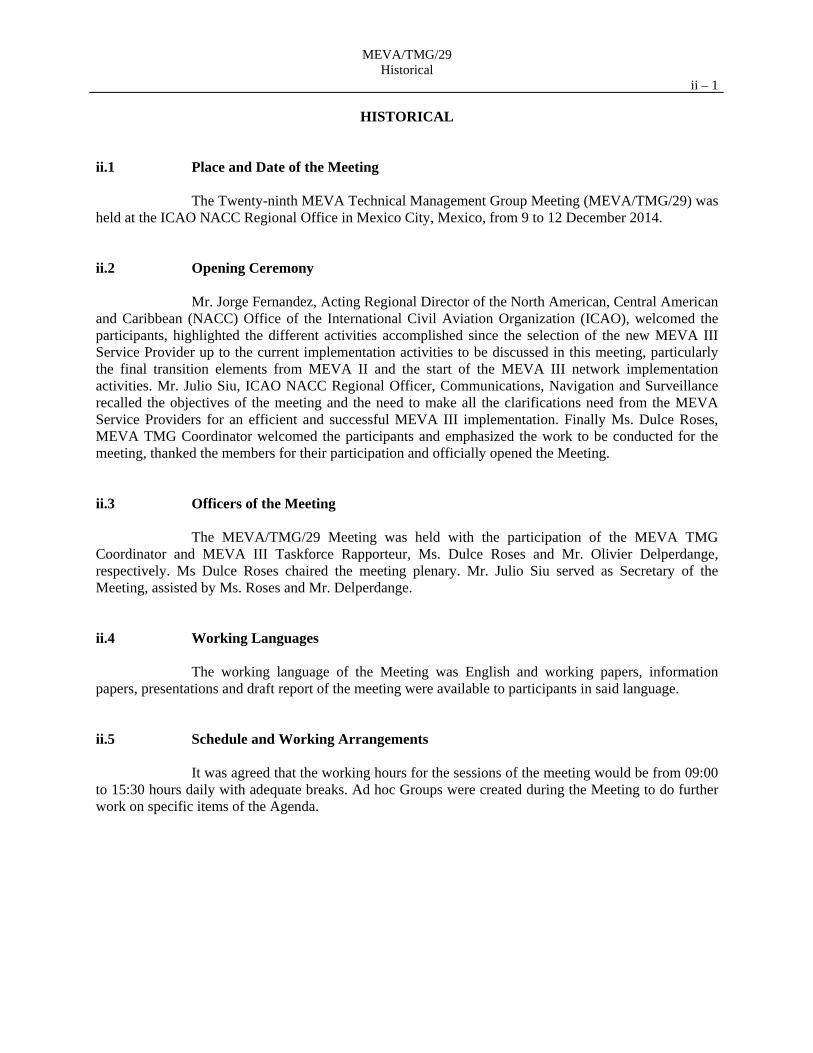
The Twenty-ninth MEVA Technical Management Group Meeting (MEVA/TMG/29) was held at the ICAO NACC Regional Office in Mexico City, Mexico, from 9 to 12 December 2014. ii.2 Opening Ceremony
Mr. Jorge Fernandez, Acting Regional Director of the North American, Central American and Caribbean (NACC) Office of the International Civil Aviation Organization (ICAO), welcomed the participants, highlighted the different activities accomplished since the selection of the new MEVA III Service Provider up to the current implementation activities to be discussed in this meeting, particularly the final transition elements from MEVA II and the start of the MEVA III network implementation activities. Mr. Julio Siu, ICAO NACC Regional Officer, Communications, Navigation and Surveillance recalled the objectives of the meeting and the need to make all the clarifications need from the MEVA Service Providers for an efficient and successful MEVA III implementation. Finally Ms. Dulce Roses, MEVA TMG Coordinator welcomed the participants and emphasized the work to be conducted for the meeting, thanked the members for their participation and officially opened the Meeting. ii.3 Officers of the Meeting
The MEVA/TMG/29 Meeting was held with the participation of the MEVA TMG Coordinator and MEVA III Taskforce Rapporteur, Ms. Dulce Roses and Mr. Olivier Delperdange, respectively. Ms Dulce Roses chaired the meeting plenary. Mr. Julio Siu served as Secretary of the Meeting, assisted by Ms. Roses and Mr. Delperdange. ii.4 Working Languages
The working language of the Meeting was English and working papers, information papers, presentations and draft report of the meeting were available to participants in said language. ii.5 Schedule and Working Arrangements
It was agreed that the working hours for the sessions of the meeting would be from 09:00 to 15:30 hours daily with adequate breaks. Ad hoc Groups were created during the Meeting to do further work on specific items of the Agenda.
MEVA/TMG/29 Historical
ii – 2
ii.6 Agenda Agenda Item 1: Review and approval of Draft Agenda and Schedule Agenda Item 2: Review of Conclusions and Actions from Previous MEVA/TMG Meetings Agenda Item 3: Operation and Performance of the MEVA II Network and Transition to
MEVA III 3.1 MEVA Network Performance and Maintenance: 05/2014-12/2014 3.2 Review of Pending Maintenance Issues Agenda Item 4: MEVA III Implementation Activities 4.1 MEVA III Task Force Report and Activities 4.2 MEVA III Documentation Review and Approval 4.3 MEVA III Interconnection Matters 4.4 MEVA II - MEVA III Transition Plan Matters 4.5 MEVA III Implementation Plan Agenda Item 5: World Radiocommunication Conference (2015) (WRC-2015) Activities Agenda Item 6: Review of MEVA/TMG Terms of Reference (ToRs) and Work Programme Agenda Item 7: Other Matters 7.1 Aviation System Block Upgrade (ASBU) Implementation and Support
review 7.2 MEVA III Go-teams 7.3 Next MEVA/TMG Meeting Preparations ii.7 Attendance
The Meeting was attended by 11 States/Territories, 2 International Organization and the MEVA II and MEVA III Service Providers, totalling 35 delegates as indicated in the list of participants.
MEVA/TMG/29 Historical
ii – 3 ii.8 List of Conclusions
The Meeting recorded its activities as Conclusions as follows:
CONCLUSIONS: Activities approved by the MEVA Members Number Title Page
29/01 CONTINUATION OF ACTIVITIES FOR MEVA/REDDIG INTERCONNECTION AFTN DATA CIRCUIT WITH BRAZIL
2-1
29/02 MEVA II NETWORK AVAILABILITY AND CREDIT CONSIDERATIONS FOR LAST MEVA II SERVICE INVOICE
3-2
29/03 MEVA II BUC FINAL POWER VALUES 3-6 29/04 REPLACEMENT OF ANTENNA FEED IN NASSAU AND FREEPORT
MEVA II NODES 3-6
29/05 ADDITIONAL CIRCUIT DOCUMENT 4-3 29/06 BANDWIDTH COST SHARING FOR ADDITIONAL MEVA III
CIRCUITS 4-4
29/07 PROCEDURE FOR MEVA III MANAGEMENT FOR ADDITIONAL MEVA III CIRCUITS
4-4
29/08 MEVA III DOCUMENTATION REVIEW AND APPROVAL 4-7 29/09 MEVA III WEBSITE- REVIEW BY MEMBERS 4-7 29/10 MEVA III POCS FOR NOC TROUBLESHOOTING 4-7 29/11 MEVA III- REDDIG II INTERCONNECTION 4-9 29/12 MEVA III EQUIPMENT DELIVERY AND INSTALLATION 4-13 29/13 MEVA III OPERATIONAL DOCUMENTS 4-14 29/14 AMHS END-TO-END TESTING BETWEEN CUBA AND ATLANTA 4-14 29/15 MEVA MEMBER´s SUPPORT FOR ICAO WRC-2015 POSITION AND
ITU VSAT NODE REGISTRATION 5-3
29/16 APPROVAL OF MEVA TMG TERMS OF REFERENCE 6-1 29/17 MEVA TMG SUPPORT FOR ANIWG/02 MEETING 7-1 29/18 ACCEPTANCE OF THE MEVA III GO-TEAM MISSIONS AND SME
DESIGNATION 7-2
29/19 MEVA TMG MEETING ROTATIONAL SCHEME 7-3

MEVA/TMG/29 Historical
ii – 4
ii.9 List of Working and Information Papers and Presentations
Refer to the Meeting web page: https://authoring2010.icao.int/NACC/Pages/meetings-2014-mevatmg29.aspx
The final list of documentation will be included in the final version of the Report.
WORKING PAPERS
Number Agenda
Item Title Date
Prepared and Presented by
WP/01 1 Provisional Agenda, Work Method and Schedule of the Twenty-ninth
MEVA Technical Management Group Meeting (MEVA/TMG/29) 19/11/14 Secretariat
WP/02 2 Review of previous valid TMG Conclusions 01/12/14 MEVA TMG Coordinator
WP/03 3.1 MEVA Network Performance and Maintenance: 05/2014-12/2014 – Transition Issues
04/12/14 SES
WP/04 3.2 Review of Pending Maintenance Issues 04/12/14 COCESNA
WP/05 4.1 MEVA III Task Force Report 04/12/14 MEVA III Task Force Rapporteur
WP/06 4.1 MEVA III – Additional Circuits Considerations 04/12/14 MEVA III TF Ad hoc Group
WP/07 4.2 MEVA III Documentation Review and Approval 07/12/14 MEVA III Task Force Rapporteur
WP/08 4.2 MEVA III Website- Trouble Ticket Mechanism 02/12/14 Jamaica
WP/09 4.3 MEVA III - REDDIG II Interconnection: documentation 07/12/14 MEVA III Task Force Rapporteur
WP/10 4.3 MEVA -REDDIG Interconnection: Review of Procedures and Agreements
19/11/14 Secretariat
WP/11 4.3 MEVA - E/CAR AFS Network Interconnection 19/11/14 Secretariat
WP/12; WP/13; WP/14
4.4; 4.5 COMSOFT Presentation for MEVA III TMG/29 10/12/14 COMSOFT
WP/15 5 The ICAO Position for the International Telecommunication Union (ITU) World Radiocommunication Conference (2015) (WRC 15) and State support requested
19/11/14 Secretariat
WP/16 6 Review of MEVA/TMG Terms of Reference (ToRs) and Work Programme
08/12/14 MEVA TMG Coordinator
WP/17 7.1 Aviation System Block Upgrade (ASBU) Implementation for inclusion in MEVA/TMG activities
19/11/14 Secretariat
WP/18 7.2 MEVA III Go-Teams: Supporting Tool from the ICAO Technical Cooperation Project (RLA/09/801) – Implementation of Performance-Based Air Navigation Systems for the CAR Region
19/11/14 Secretariat
MEVA/TMG/29 Historical
ii – 5
WORKING PAPERS
Number Agenda
Item Title Date
Prepared and Presented by
WP/19 7.3 Future MEVA/TMG Meetings 19/11/14 Secretariat
WP/20 4.1 MEVAII Voice Switched Circuits Statistics Tendency Study 19/11/14 Cuba
WP/21 5 Coordination and Notification of Earth Stations in C band in order to be recorded in the ITU Master Register (MIFR)
02/12/14 Radiocommunication Bureau, ITU
WP/22 4.2 MEVA III Testing 04/12/14 Federal Aviation Administration
INFORMATION PAPERS
Number Agenda
Item Title Date
Prepared and Presented by
IP/01 --- List of Working and Information Papers 08/12/14 Secretariat
MEVA/TMG/29 List of Participants
iii – 1
LIST OF PARTICIPANTS ARUBA Joselito M. Correia de Andrade BAHAMAS Kelly Winsett Keith Odell Major David Ferguson CUBA Carlos Jimenez Guerra Jorge Castellanos Martinez Francisco Méndez Rodriguéz CURAÇAO Jean-Baptiste Getrouw HAITI Nadia Leopold JAMAICA David Miller Alva Myers Derrick Grant MEXICO Edgardo Molina Escobar José Romero Méndez Sergio Valencia Mendez Jaime Llanes Echeverría Daniel Conrado Castañeda Cruz Héctor Abraham García Cruz PANAMA Daniel De Avila Hernández REPÚBLICA DOMINICANA Paulino Bolivar León Juan Ramón Cabrera José A. Aquino Lebron
Elvis A. Collado SINT MAARTEN Lloyd Hinds Christian President UNITED STATES Dulce M. Rosés Olivier Delperdange COCESNA Roger A. Perez COMSOFT Dominik Koch Victor Pabon Markus Tenbeck ICAO Julio Siu ITU Jorge Ciccorossi Yvon Henri SES Armando Hiraldo-Cruz

MEVA/TMG/29 List of Participants – Contact Information
iv – 1
CONTACT INFORMATION
Name / Position Nombre / Puesto
Administration / Organization Administración / Organización
Telephone / E-mail Teléfono / Correo-e
Aruba
Joselito M. Correia de Andrade Chief CNS/ATM Systems
Department of Civil Aviation Tel. +1 297 583-2665 E-mail [email protected]
Bahamas
Kelly Winsett Electronics Technician Superviser
Civil Aviation Department Tel. (242)377 2007 E-mail [email protected]
Keith Odell Major Chief Operations Officer
Civil Aviation Department Tel. +242 377 2004/5 E-mail [email protected]
David Ferguson Operations Officer
Civil Aviation Department Tel. (242)377 2007 E-mail [email protected]
Cuba
Carlos Jimenez Guerra Especialista CNS
Instituto de Aeronáutica Civil de Cuba
Tel. + 53 7838 1121 E-mail [email protected]
Jorge Castellanos Martinez Especialista Principal de Comunicaciones
ECASA Tel. (537) 266 4424 E-mail [email protected]
Francisco Méndez Rodriguéz Especialista de Comunicaciones
ECASA Tel. (537)2664168 E-mail [email protected]
Curaçao
Jean-Baptiste Getrouw CNS Manager
DC-ANSP Tel. + 599 98 39 35 15 E-mail [email protected]
Haiti
Nadia Leopold Ingenieure CNS
Civil Aviation of Haiti Tel. +509 377 11287 E-mail [email protected]
Jamaica
David Miller Regional Operations Manager
Aeronautical Telecommunicaltions Limited (AEROTEL)
Tel. +1 876 909 6317 E-mail [email protected]
Alva Myers Assistant Operations Manager
AEROTEL Tel. +876 978 3974 / 819 4446 E-mail [email protected]
Derrick Grant CNS Engineer
Jamaica Civil Aviation Authority Tel. +876-960-3948 E-mail [email protected]
MEVA/TMG/29 List of Participants – Contact Information
iv – 2 Name / Position Nombre / Puesto
Administration / Organization Administración / Organización
Telephone / E-mail Teléfono / Correo-e
Mexico
Edgardo Molina Escobar Jefe de Sistemas de Comunicaciones
Servicios a la Navegación en el Espacio Aéreo Mex
Tel. 57865524 E-mail [email protected]
José Romero Méndez Especialista de Estaciones Satelitales
SENEAM Tel. +55 5786 5525 E-mail [email protected]
Sergio Valencia Mendez Enc. Dirección de Ingenieria
SENEAM Tel. 57 86 55 25 E-mail [email protected]
Jaime Llanes Echeverría Ing. Comunicaciones
SENEAM Tel. 57 86 55 25 E-mail [email protected]
Daniel Conrado Castañeda Cruz Inspector Navegación Aeres
Dirección General de Aeronáutica Civil
Tel. + 5255 5723 9300 x. 18071 E-mail [email protected]
Héctor Abraham García Cruz Inspector Verificador Aeronáutico
Dirección General de Aeronáutica Civil
Tel. + 52 55 5723 9300 x.18071 E-mail [email protected]
Panama
Daniel De Avila Hernández Supervisor de Comunicaciones
Autoridad Aeronáutica Civil Tel. +507 315 9801/9877 E-mail [email protected]
República Dominicana
Paulino Bolivar León Director de Navegación Aérea
Instituto Dominicano de Aviación Civil (IDAC)
Tel. (809)274 4322 ext 2067 E-mail [email protected]
Juan Ramón Cabrera Encargado Departamento CNS
IDAC Tel. +809 274-4322, Ext. 2101 E-mail [email protected] [email protected]
José A. Aquino Lebron Encargadode la Sección de Redes
IDAC Tel. + 809 274 4322 ext 2200 E-mail [email protected]
Elvis A. Collado Encargado de la Div. De Com
IDAC Tel. +809 274 4322 ext. 2288 E-mail [email protected]
Sint Maarten
Lloyd Hinds Manager Radar Control Department
Princess Juliana International Airport
Tel. + 1 721 546 7536 E-mail [email protected]
Christian President Electronics Engineer
Princess Juliana International Airport
Tel. +721 546 7531 E-mail [email protected]

MEVA/TMG/29 List of Participants – Contact Information
iv – 3
United States
Dulce M. Rosés Program Manager, International Telecommunications CAR/SAM
Federal Aviation Administration (FAA)
Tel. + 1 305 716-1830 E-mail [email protected]
Olivier Delperdange Senior Engineer FAA/Noblis FAA/ITT
Federal Aviation Administration/Noblis
Tel. + 202 488 54 08 E-mail [email protected]
COCESNA
Roger A. Perez Gerente de Estación Honduras
COCESNA Tel. +504 2275 7090 ext 1601 E-mail [email protected]
COMSOFT
Dominik Koch Director Sales and Administration
COMSOFT Gmbh Tel. + 49 7062-91651-0 E-mail [email protected]
Victor Pabon Project Manager
COMSOFT GmbH / NEWCOM International
Tel. +1 305 914 1270 E-mail [email protected]
Markus Tenbeck Deputy Project Manager
COMSOFT GmbH / CSS Tel. +49 7062 916510 E-mail [email protected]
ICAO
Julio Siu Regional Officer, Communications, Navigation and Surveillance
ICAO/OACI Tel. + 52 55 5250 3211 E-mail [email protected]
ITU
Jorge Ciccorossi Sr. Engineer, Satellite Systems Coordination Division
International Telecommunication Union (ITU)
Tel. E-mail [email protected]
Yvon Henri Chief, Space Services Department
International Telecommunication Union (ITU)
Tel. E-mail [email protected]
SES
Armando Hiraldo-Cruz MEVA II Program Manager
SES-GS Government Solutions Tel. 703-610-1042 E-mail [email protected]
MEVA/TMG/29 Report on Agenda Item 1
1-1 Agenda Item 1 Review and approval of Draft Agenda and Schedule 1.1 Under WP/01, the Secretariat invited the Meeting to approve the provisional agenda and schedule and referred to IP/01 with the list of associated documentation and presentations. The Meeting approved the agenda as presented in the historical section of this report.
MEVA/TMG/29 Report on Agenda Item 2
2-1 Agenda Item 2 Review of Conclusions and Actions from Previous MEVA/TMG Meetings 2.1 Under WP/02, the Meeting reviewed the valid conclusions from the MEVA TMG/28 Meeting and followed-up on their progress. In summary, all conclusions were considered completed or superseded. The Appendix A presents the follow-up made to these conclusions. 2.2 To supersede conclusions 28/02 the following conclusion was adopted: CONCLUSION MEVA TMG/29/01 – CONTINUATION OF ACTIVITIES FOR
MEVA/REDDIGINTERCONNECTION AFTN DATA CIRCUIT WITH BRAZIL
That United States continue the coordination with Brazil to complete final testing of AFTN data circuit Atlanta-Manaus and have the data circuit implemented through the MEVA III Network by the first semester of 2015.

MEVA/TMG/29 Report on Agenda Item 3
3-1 Agenda Item 3 Operation and Performance of the MEVA II Network and Transition to
MEVA III
3.1 MEVA Network Performance and Maintenance: 05/2014-12/2014 3.1.1 Under WP/03, the MEVA II Service Provider, SES, presented information on the operation and performance of the MEVA II Network from May 2014 through Nov/Dec 2014, highlighting the following:
a) Opened 62 trouble tickets. SES informed that most of these tickets were related to customer and MEVA II equipment issues as follows in figure 1 and figure 2:
Figure 1 o 51% RFOs are
equipment related o 42% RFOs are
customer issues
Figure 2 o 40% are Modem
related o 45% are Hub
Equipment
b) The problems in the voice and data Santo Domingo-FAA circuits revealed
several systemic issues within MEVA II network that were corrected by changing the BUC and adjusting the antenna.
3.1.2 Regarding the link performance from May – November 2014, it was informed by SES that:
a) Average link availability was greater than 99.9% across the MEVA II network. b) Overall assessment, included:
o elimination un-used circuits to make more efficient use of bandwidth, improving availability
o current bandwidth (4.9MHz) is enough to support all existing / contracted voice and data circuits
o 2x AMHS circuits are currently in service. Analysis shows if FAA decides to order more AMHS circuits, additional bandwidth will be required.
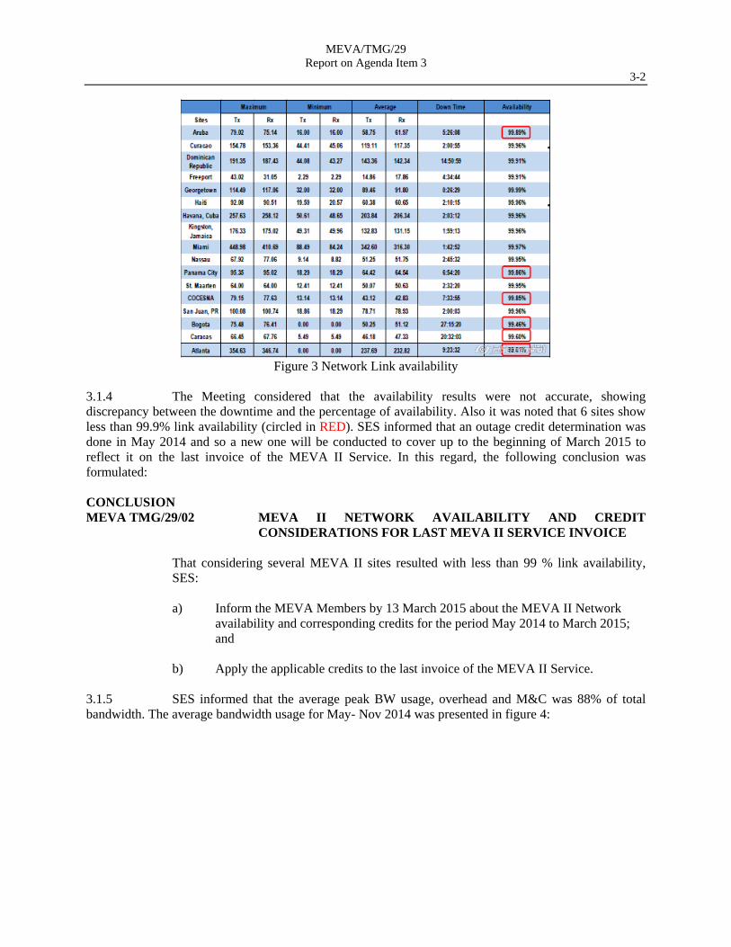
3.1.3 In this regard the MEVA III link availability figures were as shown in figure 3:
MEVA/TMG/29 Report on Agenda Item 3
3-2
Figure 3 Network Link availability
3.1.4 The Meeting considered that the availability results were not accurate, showing discrepancy between the downtime and the percentage of availability. Also it was noted that 6 sites show less than 99.9% link availability (circled in RED). SES informed that an outage credit determination was done in May 2014 and so a new one will be conducted to cover up to the beginning of March 2015 to reflect it on the last invoice of the MEVA II Service. In this regard, the following conclusion was formulated: CONCLUSION MEVA TMG/29/02 MEVA II NETWORK AVAILABILITY AND CREDIT
CONSIDERATIONS FOR LAST MEVA II SERVICE INVOICE
That considering several MEVA II sites resulted with less than 99 % link availability, SES: a) Inform the MEVA Members by 13 March 2015 about the MEVA II Network
availability and corresponding credits for the period May 2014 to March 2015; and
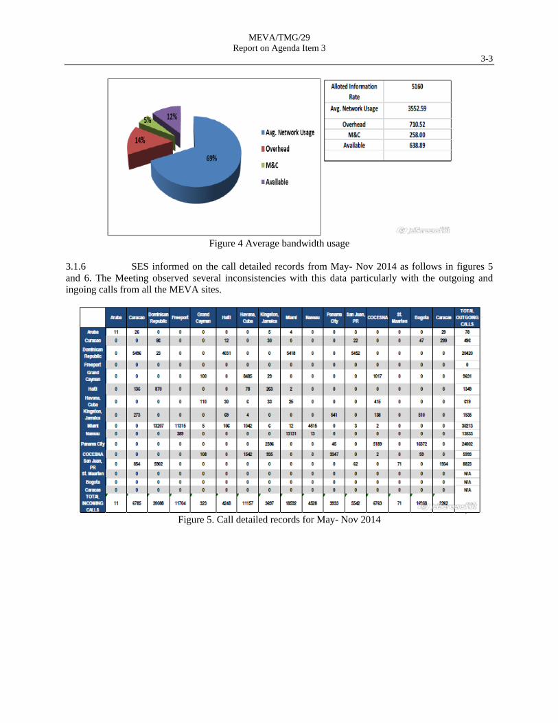
b) Apply the applicable credits to the last invoice of the MEVA II Service. 3.1.5 SES informed that the average peak BW usage, overhead and M&C was 88% of total bandwidth. The average bandwidth usage for May- Nov 2014 was presented in figure 4:
MEVA/TMG/29 Report on Agenda Item 3
3-3
Figure 4 Average bandwidth usage
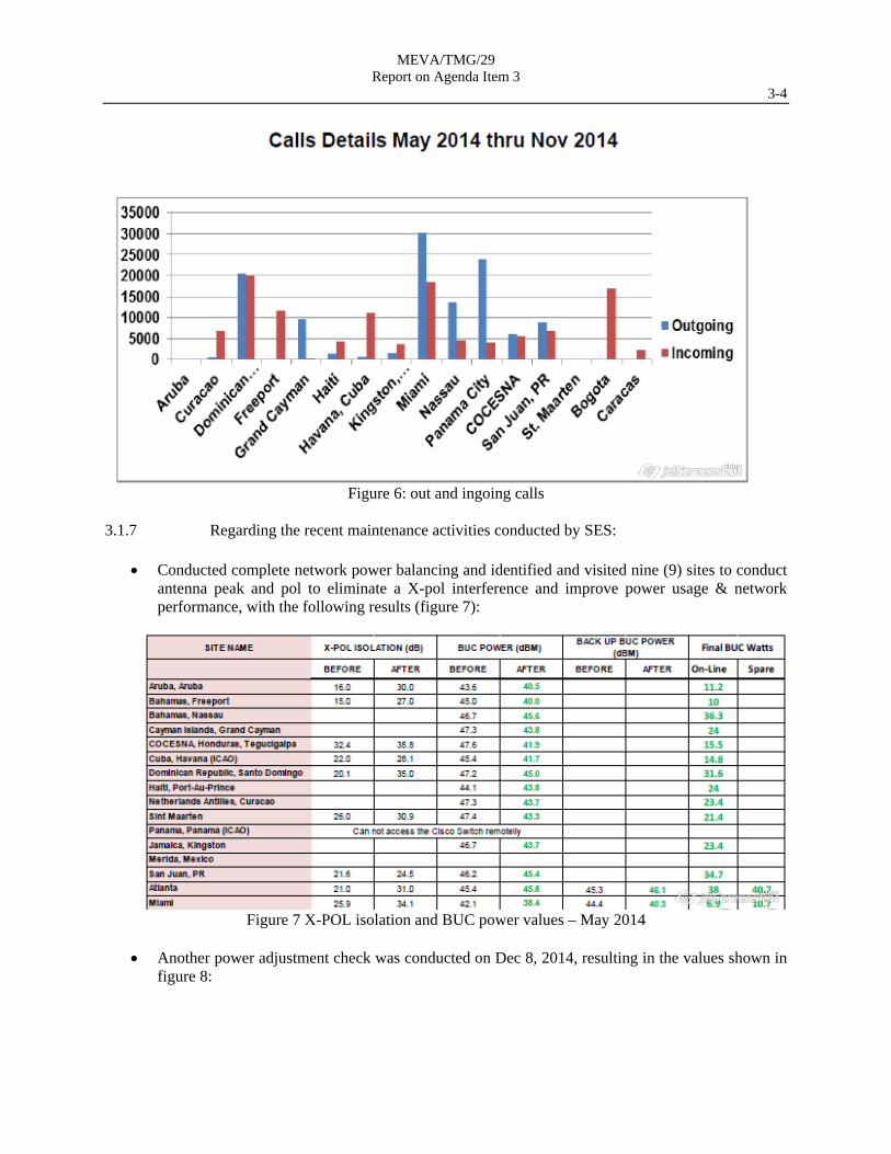
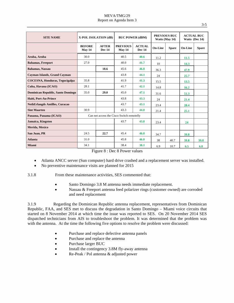
3.1.6 SES informed on the call detailed records from May- Nov 2014 as follows in figures 5 and 6. The Meeting observed several inconsistencies with this data particularly with the outgoing and ingoing calls from all the MEVA sites.
Figure 5. Call detailed records for May- Nov 2014
MEVA/TMG/29 Report on Agenda Item 3
3-4
Figure 6: out and ingoing calls
3.1.7 Regarding the recent maintenance activities conducted by SES:
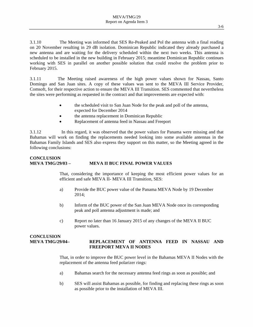
Conducted complete network power balancing and identified and visited nine (9) sites to conduct antenna peak and pol to eliminate a X-pol interference and improve power usage & network performance, with the following results (figure 7):
Figure 7 X-POL isolation and BUC power values – May 2014
Another power adjustment check was conducted on Dec 8, 2014, resulting in the values shown in
figure 8:
MEVA/TMG/29 Report on Agenda Item 3
3-5
SITE NAME X-POL ISOLATION (dB) BUC POWER (dBM) PREVIOUS BUC Watts (May 14)
ACTUAL BUC Watts (Dec 14)
BEFORE May 14
AFTER Dec 14
PREVIOUS May 14
ACTUAL Dec 14
On-Line Spare On-Line Spare
Aruba, Aruba 30.0 40.5 40.6 11.2 11.5
Bahamas, Freeport 27.0 40.0 41.7 10 14.3
Bahamas, Nassau 18.6 45.6 46.8 36.3 47.9
Cayman Islands, Grand Cayman 43.8 44.1 24 25.7
COCESNA, Honduras, Tegucigalpa 35.8 41.9 41.3 15.5 13.5
Cuba, Havana (ICAO) 28.1 41.7 42.1 14.8 16.2
Dominican Republic, Santo Domingo 35.0 29.0 45.0 47.1 31.6 51.3
Haiti, Port-Au-Prince 43.8 43.3 24 21.4
NethErlangds Antilles, Curacao 43.7 43.1 23.4 20.4
Sint Maarten 30.9 43.3 44.0 21.4 25.1
Panama, Panama (ICAO) Can not access the Cisco Switch remotelly
Jamaica, Kingston 43.7 43.8 23.4 24
Merida, Mexico
San Juan, PR 24.5 22.7 45.4 46.0 34.7 39.8
Atlanta 31.0 45.8 46.0 38 40.7 39.8 39.8
Miami 34.1 38.4 38.1 6.9 10.7 6.5 6.8
Figure 8 : Dec 8 Power values
Atlanta ANCC server (Sun computer) hard drive crashed and a replacement server was installed. No preventive maintenance visits are planned for 2015
3.1.8 From these maintenance activities, SES commented that:
Santo Domingo 3.8 M antenna needs immediate replacement. Nassau & Freeport antenna feed polarizer rings (customer owned) are corroded
and need replacement
3.1.9 Regarding the Dominican Republic antenna replacement, representatives from Dominican Republic, FAA, and SES met to discuss the degradation in Santo Domingo – Miami voice circuits that started on 8 November 2014 at which time the issue was reported to SES. On 20 November 2014 SES dispatched technicians from AIS to troubleshoot the problem. It was determined that the problem was with the antenna. At the time the following five options to resolve the problem were discussed:
Purchase and replace defective antenna panels Purchase and replace the antenna Purchase larger BUC Install the contingency 3.8M fly-away antenna Re-Peak / Pol antenna & adjusted power
MEVA/TMG/29 Report on Agenda Item 3
3-6 3.1.10 The Meeting was informed that SES Re-Peaked and Pol the antenna with a final reading on 20 November resulting in 29 dB isolation. Dominican Republic indicated they already purchased a new antenna and are waiting for the delivery scheduled within the next two weeks. This antenna is scheduled to be installed in the new building in February 2015; meantime Dominican Republic continues working with SES in parallel on another possible solution that could resolve the problem prior to February 2015. 3.1.11 The Meeting raised awareness of the high power values shown for Nassau, Santo Domingo and San Juan sites. A copy of these values was sent to the MEVA III Service Provider, Comsoft, for their respective action to ensure the MEVA III Transition. SES commented that nevertheless the sites were performing as requested in the contract and that improvements are expected with:
the scheduled visit to San Juan Node for the peak and poll of the antenna, expected for December 2014
the antenna replacement in Dominican Republic Replacement of antenna feed in Nassau and Freeport
3.1.12 In this regard, it was observed that the power values for Panama were missing and that Bahamas will work on finding the replacements needed looking into some available antennas in the Bahamas Family Islands and SES also express they support on this matter, so the Meeting agreed in the following conclusions: CONCLUSION MEVA TMG/29/03 – MEVA II BUC FINAL POWER VALUES
That, considering the importance of keeping the most efficient power values for an efficient and safe MEVA II- MEVA III Transition, SES:
a) Provide the BUC power value of the Panama MEVA Node by 19 December
2014;
b) Inform of the BUC power of the San Juan MEVA Node once its corresponding peak and poll antenna adjustment is made; and
c) Report no later than 16 January 2015 of any changes of the MEVA II BUC power values.
CONCLUSION MEVA TMG/29/04– REPLACEMENT OF ANTENNA FEED IN NASSAU AND
FREEPORT MEVA II NODES
That, in order to improve the BUC power level in the Bahamas MEVA II Nodes with the replacement of the antenna feed polarizer rings: a) Bahamas search for the necessary antenna feed rings as soon as possible; and b) SES will assist Bahamas as possible, for finding and replacing these rings as soon
as possible prior to the installation of MEVA III.
MEVA/TMG/29 Report on Agenda Item 3
3-7 3.1.13 SES informed on the follow-up to the action items made between SES and United States as well as an overview of the current MEVA II network spare inventory. 3.1.14 Regarding the transition activities for MEVA III, SES commented that:
SES GS is working with ComSoft to support transition Met several times to discuss current status of MEVA II network as it related to
transition Entered into agreement with ComSoft to remove the MEVA II SES GS owned
equipment after transition is completed for all sites except San Juan & Cuba SES GS gained agreements with MEVA II sites to take ownership of the MEVA
II equipment after transition to MEVA III is complete SES will remove the MEVA II equipment from the San Juan site Armando Hirardo will be the SES GS POC for the MEVA II – MEVA III
transition 3.1.15 SES presented a contract milestone table concluding:
That all MEVA Members, except COCESNA and Panama (ICAO) had signed and submitted the Service order for the extension of the MEVA II Service; however SES is directly contacting COCESNA and Panama for managing the pending Service Orders for its signature.
All pending MEVA II payments with the MEVA Members are being handled by SES with the corresponding MEVA Members.
3.1.16 Finally the Meeting informed SES that the pending circuits (voice and data circuits Sint- Maarten – San Juan and the AMHS circuits between Atlanta and Curacao, Jamaica and Sint Maarten) will not be implemented through MEVA II.
3.2 Review of Pending Maintenance Issues
3.2.1 Under WP/04, the Meeting noted that apart from SES maintenance overview, the MEVA III Task Force consolidated and reviewed the list of pending maintenance issues of the MEVA II network, requesting the MEVA members their pending maintenance issues. Pending maintenance issues were only identified from the United States:

MEVA/TMG/29 Report on Agenda Item 3
3-8 3.2.2 The Meeting concluded that these pending maintenance issues had been covered with SES maintenance overview and no maintenance issues were identified with the MEVA II network.
MEVA/TMG/29 Report on Agenda Item 4
4-1 Agenda Item 4 MEVA III Implementation Activities
4.1 MEVA III Task Force Report and Activities
MEVA III Task Force Activities 4.1.1 Under WP/05, the Task Force Rapporteur presented the work done by the MEVA III Task Force in support of the implementation of the MEVA III Network and the status of completion of the various chapters of the MEVA III System Design Document (SDD). 4.1.2 It was recalled that since the TMG/28 Meeting, the MEVA III Task Force conducted five MEVA III TF teleconferences, three MEVA III TF / COMSOFT teleconferences, and one MEVA/TF/03 meeting during which the TF review the documentation delivered by COMSOFT. The MEVA III TF/3 report and teleconferences minutes are available in the MEVA III Website under the ICAO secure Portal. 4.1.3 During the MEVA/TF/03 Meeting the TF tackled the following:
coordinated the Dial and the Interface Plans with all MEVA Members. The material was included in the MEVA III SDD.
Provided initial comments to the MEVA III website. Ensured that COMSOFT is aware of the particularities of the MEVA-REDDIG
interconnection through the Dial and Interface Plans. 4.1.4 The Meeting acknowledged and congratulated the Task Force for the work performed. MEVA II voice switched circuits study 4.1.5 Cuba presented under WP/20, a study on MEVA II voice switched circuits, comparing the switch voice circuits use in MEVA II in 2013 and 2014 and how this can affect in the MEVA III network with the following conclusions:
a) the traffic tendency is to grow over 50 calls in the peak hour; and b) this grow can cause a switched bandwidth overload in a heavy traffic hour.
4.1.6 Finally Cuba suggested two ways to solve this potential issue in the future:
Assign more bandwidth to the switched voice circuits. Establish more direct circuits between the nodes with heavy switched voice
traffic. 4.1.7 The Meeting thanked Cuba for the information and agreed that all MEVA Members were to analyse their switched voice circuits’ performance together with the end users, and conduct the necessary actions for any improvement.
MEVA/TMG/29 Report on Agenda Item 4
4-2 Document on Considerations for MEVA III Additional circuits
4.1.8 Under WP/06, the Meeting was informed by the MEVA III TF Ad-hoc group of the clarifications needed on the price for future circuits/ additional services during the life of the MEVA III Network. Two COMSOFT documents regarding the cost for additional channels were analysed:
Commercial Offer “Options Upgrade” document dated 12 Dec 2103 Workbook file containing a “Channel Cost Calculator”
4.1.9 In this regard, COMSOFT recalled that no fix prices were provided for new circuits/services and so explained the following table (table 1), which represents the worst case scenario and clarified:
a) Service (Circuits) fee is to be shared by both ends b) Space Segment fee is to be applied for additional 100 KHz bandwidth if no more
bandwidth is available to accommodate the new service/ circuit. c) The Lease Site 1 and 2 fees are to be applied only if the equipment needed for the
new service is not already installed. This amount is the same if just one card or more hardware is installed.
d) VHF-PTT typed circuit involved all E&M circuits e) New voice switched circuit may be added with no additional bandwidth if the
specified Erlang B call blocking probability is not exceeded
Table 1
4.1.10 Comsoft also clarified that the “Channel Cost Calculator” was applicable for calculating the existing MEVA III node circuits (table 2).

MEVA/TMG/29 Report on Agenda Item 4
4-3
Table 2
4.1.11 In order to conduct the evaluation for additional circuits, the meeting requested Comsoft information on:
a) for table 1, to provide the site lease cost for an AMHS channel. b) Periodic provision of the status of bandwidth usage/availability and Erlang B call
blocking probability 4.1.12 To satisfy the requested information and based on the Comsoft Commercial Offer “Options Upgrade” document , COMSOFT agreed to develop a document upon which the MEVA Members will be able to calculate the cost of future services and provide the periodic information via the monthly report 4.1.13 The Meeting made the following agreements for managing request and implementation for new circuits/ services:
a) agreed that the MEVA Network Coordinator supported by the MEVA TMG, will be the focal point for requesting new circuits and officially communicating the request to Comsoft.
b) For distributing the cost when a new 100kHz of bandwidth needs to be added to satisfy new circuits, the Meeting reached the agreement that the cost of each 100 kHz of additional bandwidth should be share equally among all MEVA Members
c) Evaluation for new circuits, shall be every quarter as needed using the monthly report information (Erlang B blocking probability and bandwidth availability)
d) advanced planning in this matter is a must to be applied to anticipate new bandwidth
4.1.14 The Meeting assigned the MEVA III Task Force to develop before the end of February 2015 a procedure based on the agreements detailed in paragraph 4.1.13 through which new service requirements will be vetted against the available bandwidth, and, if required, inform the MEVA Members that an increase of bandwidth is warranted. To that effect, the Meeting requested that COMSOFT provide the current figure of bandwidth available. In this regard the following Conclusion was agreed: CONCLUSION MEVA TMG/29/05 ADDITIONAL CIRCUIT DOCUMENT
That, in order to have a single document containing the prices and conditions applicable for additional circuits and valid during the lifetime of the MEVA III Network, Comsoft:
a) provide the current figure of bandwidth available by the end of December;
b) include in the monthly report the information on Erlang B blocking probability
and bandwidth availability; and
c) develop by February 12, 2015 a document detailing the conditions and prices for additional circuits and the procedure to follow for any additional circuit implementation; considering that the MEVA III Network Coordinator is the focal point.
MEVA/TMG/29 Report on Agenda Item 4
4-4 CONCLUSION MEVA TMG/29/06 BANDWIDTH COST SHARING FOR ADDITIONAL MEVA III
CIRCUITS
That, considering bandwidth increases may be required for new MEVA III circuits; the MEVA Members agreed that the cost ($500) of each bandwidth 100kHz increment be equally shared among all Members.
CONCLUSION MEVA TMG/29/07 PROCEDURE FOR MEVA III MANAGEMENT FOR
ADDITIONAL MEVA III CIRCUITS
That, in order to manage as a Group any additional circuit requirement, the MEVA III Task Force develop by February 20, 2015 a procedure to plan, manage, inform and approve new circuits requirements including bandwidth increase and communication requirements. This procedure must be based on the MEVA Members Group agreements detailed in paragraph 4.1.13 of this report.
4.2 MEVA III Documentation Review and Approval
MEVA III Documentation overview 4.2.1 Under WP/7 the MEVA III TF presented the status of development, review and approval of the MEVA III documentation, summarized as following:
a) Chapter 1: VSAT-SDD - Chapter 1_SDD - Network Design Document_V1.5 Pending changes are:
Cuba/Atlanta AFTN circuit to be changed to 19200bps. The 19.2kbps data rate was specified in the MEVA III RFP. COMSOFT agreed to make the change without effect on price.
Dominican Republic Winchester connector. The Dominican Republic indicated that a Winchester connector for the AMHS circuit was never specified. The correct connector is V.35/DB-25.
Aruba/Caracas Shoutline to be Hardware Only/No Service Curacao/Bogota Shoutline to be Hardware Only/No Service Sint Maarten agreed to change the AMHS circuit interface from Ethernet to
Serial due to the impossibility of COMSOFT to accommodate an Ethernet interface on one end of a circuit and serial on the other end.
Cayman Islands Ethernet. . The Task Force will contact the Cayman Islands to resolve this issue.
MEVA – REDDIG interconnection paragraph to be expended to include technical details of the sync-async X.25 interconnection in Bogota REDDIG node.
b) Chapter 1 Annex: VSAT-SDD - Chapter 1_MEVA III_Annex – SkyWAN
System Description_V1.1: Approved by MEVA Members
MEVA/TMG/29 Report on Agenda Item 4
4-5
c) Chapter 2: VSAT-SDD - Chapter 2_MEVA III_Network-Overview_v1.7d Approved pending changes to Chapter 1
d) Chapter 3: VSAT-SDD_MEVA III_LB_V1.0 Approved by MEVA Members
e) Chapter 4: VSAT-SDD - Chapter 4_MEVA III_Port Connections_V1.3 Approved pending changes to Chapter 1
f) Chapter 5: VSAT-SDD - Chapter 5_MEVA III - Rack Drawings_V1.3 Approved by MEVA Members
g) Chapter 6: VSAT-SDD - Chapter 6_MEVA III_Project Implementation Schedule_V5.6
Version 5.7 was delivered during the meeting. Dates for installation of Curacao node were identified.Pending changes included; and so a new version was provided as version 5.8 and later a last version as 5.9. Versions 5.8 and 5.9 are practically the same just with a change for Atlanta installation.
Approved by MEVA Members
h) Chapter 7: VSAT-SDD_MEVA III_TSP_V1.2 Comments submitted to COMSOFT, waiting for new update
i) Chapter 8: VSAT-SDD_MEVA III_TRP_V1.2 Version provided during the TMG/29 Meeting. Cuba’s request to have It’s training in Havana has been resolved. MEVA Members OK with Training blocks proposal. Approved by MEVA Members
j) Chapter 9: VSAT-SDD_MEVA III_Security Plan_V1.1 Under review by the Task Force: target date: 30 January 2015
k) Chapter 10: VSAT-SDD_MEVA III-Statistics Template_V1.1 Missing main text of this chapter. Awaiting COMSOFT to provide: 30 January 2015 Annex 1: monthly report template: COMSOFT to include the amount of spare bandwidth available for new services and Erlang B Probability Status. Annex 2- Chapter 10: VSATSDD_MEVA III_TicketSystem_V1.0 Under review by the Task Force: target date: 30 January 2015 Annex 3- sun outages: Provided during TMG/29 Under review by the Task Force: target date: 30 January 2015
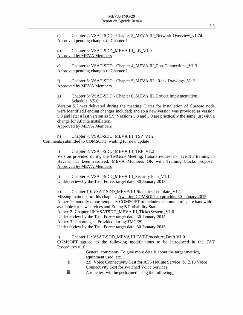
l) Chapter 11: VSAT-SDD_MEVA III FAT-Procedure_Draft V1.0 COMSOFT agreed to the following modifications to be introduced in the FAT Procedures v1.0:
i. General comment: To give more details about the target metrics, equipment used, etc…
ii. 2.9 Voice Connectivity Test for ATS Hotline Service & 2.10 Voice Connectivity Test for switched Voice Services
iii. A tone test will be performed using the following:
MEVA/TMG/29 Report on Agenda Item 4
4-6
iv. A voice quality test will be performed. The test is as follow:
A short sentence (see below) reflecting what a controller would typically say will be said and an assessment of the Signal Quality (Loudness) and Voice Readability (Clearness) be made. If it the sentence is heard “Loud and Clear” it would pass. The results will be recorded. The sentence is: Flight Level three Height Zero; Clear to land; Alpha Kilo Niner
v. 2.11 Serial Link Test: An AMHS system is to be connected to the circuit. 100 messages will be sent and the reception of each will be validated.
Approved by MEVA Members with comments to be included. Version 1.2 was submitted by Comsoft.
SAT Procedures will be delivered on 5 January 2015 at the latest. NAT Procedures will be delivered on 5 January 2015 at the latest.
m) Chapter 12: VSAT-SDD_MEVA III_WebPage_V1.0
COMSOFT agreed to add to the MEVA III Webpage: link/button to the NOC Web monitoring, similar to the Trouble Ticket System
link/button. (design of this site to be provided) Help button User manual
MEVA III prototype: http://noc.comsoft-sat.com:7543
User : MEVA Password : MEVA
MEVA/TMG/29 Report on Agenda Item 4
4-7 Chapter 13 Glossary To be delivered once all other chapters are completed. CONCLUSION MEVA TMG/29/8 MEVA III DOCUMENTATION REVIEW AND APPROVAL
That, in order to continue and streamline the review and approval process of the SDD:
a) COMSOFT to provide the updated SDD chapters (1, 2, 4, 6, 7, 9,10, 11, 12) with the changes highlighted and dates detailed in this agenda item;
b) COMSOFT to deliver the SAT and NAT Procedures on 5 January at the latest; and
c) Task Force to review the changes and recommend the documents to the TMG for approval
MEVA III Website prototype 4.2.2 In WP/08, Jamaica presented a review of the proposed MEVA III Website and Trouble Ticket System. COMSOFT indicated that the web-based monitoring will be available after the Miami NOC is implemented. 4.2.3 COMSOFT agreed to add to the MEVA III Webpage a link/button to the NOC Web monitoring, similar to the Trouble Ticket System link/button (design of this site to be provided), Help button and User manual. COMSOFT requested a Points of Contact list for inclusion in the Trouble Ticket System directory. In this regard the following Conclusions were formulated: CONCLUSION MEVA TMG/29/09 MEVA III WEBSITE- REVIEW BY MEMBERS
That, in order to process on the review and approval of the MEVA III Website and its features, all MEVA Members to evaluate this website (http://noc.comsoft-sat.com:7543) and provide comments by 30 January 2015.
CONCLUSION MEVA TMG/29//10 MEVA III POCS FOR NOC TROUBLESHOOTING
That for the appropriate operation and coordinate of the NOC, MEVA III TF to compile the list of Point of Contact for inclusion in the directory of the Trouble Ticket System by 30 January 2015.
4.3 MEVA III Interconnection Matters
MEVA III- REDDIG II Interconnection
4.3.1 Under WP/10 and WP/9, the Meeting was recalled on the need to review and update the associated procedures and agreements of the MEVA II REDDIG Interconnection considering the implementation on the new REDDIG II and MEVA III Networks.
MEVA/TMG/29 Report on Agenda Item 4
4-8 4.3.2 The final MEVA II REDDIG interconnection requirements, which have been also requested on the MEVA III tender process, were as follows:
No. Sites Requirement
1 2 3 Connectivity through the Caracas, Venezuela site 1 Curaçao/Caracas (Venezuela) 1 ATS voice
1 AFTN data, 2400 bps, X.25, IA-5 2 Aruba/Josefa Camejo (Venezuela) 1 ATS voice
3 Atlanta (United States)/Caracas (Venezuela) 1 AFTN data, 9600 bps, X25, IA-5
4 Puerto Rico/Caracas (Venezuela) 1 ATS voice
Connectivity through the Bogota, Colombia site 5 Barranquilla (Colombia)/Curaçao
Barranquilla (Colombia)/Jamaica Barranquilla (Colombia)/Panama
ATS voice
6 Bogota (Colombia)/Panama 1 AFTN data, 2400 bps, X25, IA-5 7 Bogota (Colombia)/Panama
Cali (Colombia)/Panama Medellin (Colombia)/Panama San Andrés (Colombia)/Panama
ATS voice
8 Lima (Peru) / Atlanta (United States) 1 AFTN data, 9600 bps, X25, IA-5 9 Atlanta (United States)/Manaus (Brazil) 1 AFTN data, 9600 bps, X25, IA-5
4.3.3 From coordination with the REDDIG Administration, the only requirement is still to be fully operational is the AFTN Data circuit Atlanta-Brasilia. 4.3.4 The upgrades and major changes to the REDDIG Network were provided together with the REDDIG II Implementation schedule:
States have almost fully completed the customs process of the equipment and
some are already onsite in their respective sites Physical installation of all equipment is scheduled to be finished by the end of the
first week of December 2014 The network commissioning will be on the week of January 19, 2014 Regarding the REDDIG installation in the MEVA Node in COCESNA; by the
week of Nov 24 the REDDIG Equipment will be delivered to the site with installation and operation planned for the week of January 19, 2015.
4.3.5 The ICAO NACC and SAM Regional Offices have agreed on conducting the MEVA III- REDDIG II interconnection meeting from 25 to 26 May 2015 in Aruba prior to the MEVA TMG/30 Meeting. 4.3.6 The Meeting took note that the following two documents were agreed among the MEVA and REDDIG Systems:
MEVA – REDDIG interconnection Management agreements- MEVA- REDDIG network integration considerations
MEVA/TMG/29 Report on Agenda Item 4
4-9 4.3.7. And so were reviewed by the Task Force. The TMG Meeting decided to create an ad-hoc group with representatives of Aruba, Curacao, COCESNA, United States to review the MEVA II – REDDIG Memorandum of Agreement document and propose an updated version taking into account the implementation of REDDIG II and MEVA III. 4.3.8. The ad-hoc group reviewed the documents and proposed changes. The Task Force will consolidate the proposed changes, and circulate a final draft of the MEVA III – REDDIG II Memorandum of Agreement to the TMG Members by the end of the year. The TF will then compile and address the TMG Members comments with the goal to finalize a draft to be presented during the MEVA III-REDDIG II Interconnection Coordination meeting. CONCLUSION MEVA TMG/29/11 MEVA III- REDDIG II INTERCONNECTION
In preparation for the upcoming MEVA III-REDDIG II interconnection/ integration discussions,
a) That the MEVA III TF is to finalize the draft of the MEVA III – REDDIG II
interconnection/integration documents and submit it to the MEVA Members for approval by 15 march 2015; and
b) All MEVA Members to identify 2014 as needed by 6 April any future
interconnection requirements for discussion with the REDDIG Network;
MEVA III- E/CAR AFS Interconnection 4.3.9 Under WP/11 the Meeting was informed on the progress and results of the E/CAR – MEVA II interconnectivity in light of the MEVA III Network implementation, whose requirements are: ATS Units Technical details
SINT MAARTEN/ JULIANA APP
Anguilla (Clayton J. Lloyd International)
2 PBX service from ECAR-analog voice line
Antigua (V. C. Bird APP) 1 PBX service from ECAR-analog voice line
Saint Kitts (Robert L. Bradshaw TWR)
1 PBX service from ECAR-analog voice line
PIARCO ACC 1 Serial line, RS232
4.3.10 The Meeting was informed that eight different teleconferences had been conducted to complete the implementation of the ECAR AFS Network- MEVA II interconnection. The following configurations were agreed:
MEVA/TMG/29 Report on Agenda Item 4
4-10
4.3.11 From the E/CAR/NTG/05 Meeting, it was agreed that the implementation was to be postponed for the MEVA III Network. The following agreements were made:
a) 4 voice circuits will be implemented thru MEVA III and not MEVA II, so Trinidad and Tobago confirm the availability of the existing OPX circuits until this implementation. Sint Maarten reconfirmed that the total cost of the implementation of these 4 voice circuits through MEVA III will be covered by Saint Maarten.
MEVA/TMG/29 Report on Agenda Item 4
4-11
b) the radar feed of Pico del Este will be the required radar feed to be exchanged with Saint Maarten.
c) United States confirmed their commitment to exchange radar data, but also recognized that currently they cannot process external radar data feed into San Juan. In this regard, United States indicated that they can provide the Pico del Este radar feed to Sint Maarten only. Sint Maarten will then pay for the total data circuit for the radar data feed from Pico del Este radar.
d) Trinidad and Tobago commented the operational need for sharing this same Pico del Este radar feed for benefit of the PIARCO FIR- San Juan FIR coordination and Antigua APP- San Juan ACC. Trinidad and Tobago will be responsible for the format conversion to integrate it into their Multiradar data processor.
4.3.12 The MEVA II – E/CAR AFS Network interconnection minutes are available in the MEVA III secure portal website. The MEVA II – E/CAR AFS Network interconnection requirements are part of the MEVA III network implementation. 4.3.13 In this regard, the Meeting agreed consider the necessary transition actions for the SAT/NAT in Puerto Rico and Saint Maarten MEVA III Nodes for the Interconnection with the E/CAR AFS.
4.4 MEVA II - MEVA III Transition Plan Matters
4.4.1 During the Meeting, an Adhoc Group was created by Markus Tenbeck (COMSOFT), Armando Hiraldo (SES), D. Roses (FAA), CUBA, Jamaica, Dom.-Rep, Bahamas for discussing the MEVA II- MEVA III transition items, concluding in the following:
Cuba: Has two antennae in place, where SES do not see any problem in using the new one. Conclusion: No problem
San Juan: Intelsat claims x-pole problems. SES has to visit the site again ASAP.
SES sees no problem in fixing the station. Conclusion: No problem.
Nassau: Hardware problems Feed-Ring has to be changed, that will cause
outages. Antenna/feed need to be re-aligned to reach good x-pole. Bahamas & SES coordinating the work needed. Conclusion: Spare part delivery time could be too long, if part is not available on stock. Technically the problem can be solved. If not, Bahamas will decide to buy a new antenna.
Dominican Republic:
Conclusion: Dom.-Rep has a new antenna in stock and will install it on their own until start of transition, latest. Problem solved.
MEVA/TMG/29 Report on Agenda Item 4
4-12
Atlanta: Antenna at station is OK. Due to already using two carriers (MRT &
Data) 3 dB back-off is taken and no more spare left for the MEVA III carrier. SES is checking the possible to concentrate the traffic on one modem (MRT and Traffic combined on one modem). Conclusion: SES will internally discuss the possibility of combining. If this does not work, COMSOFT will implement a 60 W BUC in order to overcome during transition phase.
Merida: No transition problem, since the MEVA II network is switched off there.
4.5 MEVA III Implementation Plan 4.5.1 Under Presentation PPT01 and WP/12-13/14, several implementation and installation matters were explained by Comsoft Local partner, NEWCOM described the activities in different stages dealing with MEVAII to MEVAIII migration Plan: Stage 01: Approval by MEVA III TMG of the Transition Plan presented with the SDD. Stage 02: Installation of the Master Station in the Teleport Miami, FL includes a test
configuration for the simulation of aeronautical voice and data applications as part of the SAT. On completion the SkyWAN carrier is on air and the satcom network is ready for inclusion of operational MEVA III terminals.
Stage 03: Installation of the Backup Master Station in Atlanta. Stage 04: A few minutes interruption at the Atlanta terminal is necessary to introduce a L-Band combiner indoors to combine the carriers of an old and new modem on the transmit IFL
cable and an L-Band splitter indoors to feed the receive signal from the IFL cable to both modems.
Stage 05: In the subsequent, SAT for Atlanta application tests as agreed and approved by MEVA III TMG, between Atlanta and the Teleport, will be conducted and site acceptance will be achieved.
Stage 06: Corresponding to steps (3) – (5), another MEVA III Network site, i.e. the first “remote site” in terms of the terminal/network node functions, will be installed and subjected to the SAT.
Stage 07: Within the 3-site network configuration the switching between Master and Backup Master can be tested.
Stage 08: In repetition of step (6), all other MEVA III Network sites will be installed by the installation teams, where several teams working in parallel to minimize the migration period with operational costs for 2 networks and subsequently subjected to the SAT.
Stage 09: Now, all MEVA III Network sites are ready for switch-over in active services. The technical staff of the MEVA Member States has during the On-the-Job Training been instructed on the available interfaces and the connectors. Thus the active connections can now be transferred, one by one or in parallel, from MEVA II Network to MEVA III Network in coordination between technical staff of both affected sites by reconnecting to the MEVA III multiplexer interfaces. This process is accompanied by COMSOFT´s Helpdesk Support for the technicians at both sites - Miami and Atlanta.
MEVA/TMG/29 Report on Agenda Item 4
4-13 Stage 10: After transfer of all active services to MEVA III Network the Linkway2100 carriers
will be idle and can be shut down. Thereafter all MEVA II indoor equipment can be decommissioned.
Stage 11: The transition will be concluded with an adjustment of the modulation and coding to its final values. This involves a brief shut down of the network followed by a reboot with the new parameters
4.5.2 Similarly, Comsoft listed their local partners for the implementation and indicated the availability of two local partners for the site installations, which will streamline each node installation. The next activities in the implementation apart from the FAT, are the equipment delivery, for which Comsoft indicated that this delivery will start on time. In this regard the following conclusion was agreed: CONCLUSION MEVA TMG/29/12 MEVA III EQUIPMENT DELIVERY AND INSTALLATION
In preparation for the equipment delivery of MEVA III, Comsoft
a) to coordinate with each MEVA Member PoC the documentation for the delivery, providing all the shipping documentation in advanced for its customs clearance; and
b) submit the installers ‘information (Passport, etc.) and list of tools to be use in the
node installation by 19 December 2014 4.5.3 Comsoft commented the Meeting of the provision of the MEVA III Operational documentation, clarifying Comsoft that these documents are to be independent documents from the SDD and for exclusive use in the operation and maintenance of the network. These documents are part of the MEVA III RFP deliverables:
Contingency Plan Maintenance Plan (Preventive and Corrective) NOC Operational Manual Trouble Ticket System Manual
4.5.4 Comsoft delivered Contingency Plan v1.0 with Appendix A - Intelsat Restoration Process v1.0, and the Troubleshooting Flow Chart v1.0
MEVA/TMG/29 Report on Agenda Item 4
4-14 CONCLUSION MEVA TMG/29/13 MEVA III OPERATIONAL DOCUMENTS
That to review and approve the necessary MEVA III Operational documents:
a) COMSOFT delivers by 23 January 2015, the following document: Maintenance Plan (Preventive and Corrective) NOC Operational Manual Trouble Ticket System Manual
b) The Task Force to review the documentation provided, and recommend it for approval before the Network Acceptance Test (NAT) in March 2015.
AMHS Interoperability Testing 4.5.5 Under WP/22, United States presented information on a proposed end-to-end AMHS testing. The MEVA III Network will carry operational data from day one, including AFTN and AMHS messages generated from disparate systems. In order to increase the likelihood that these systems will continue to function as intended the FAA, in agreement with Cuba, proposes to carry out a test to see how the MEVA III network will interface with existing systems. 4.5.6 Currently, on MEVA II, a test circuit is used to perform AMHS interoperability testing between Cuba and FAA’s Technical Center. This circuit does not carry operational traffic, and therefore can be used to perform testing over MEVA III before the NAT. Once Havana and Atlanta have been installed and passed the SAT, both end of the MEVA II circuit will be disconnected and connected to the MEVA III AMHS ports. A series of message exchange tests will then be performed to validate end-to-end communication. Once this series of test is performed, the circuit will remain “up”, and Cuba and FAA routers on both ends would exchange periodically data that, upon analysis, will show how the link is performing over time. 4.5.7 In the implementation schedule v5.6, the SAT for the Cuba node is scheduled on 16 February 2015, and the Atlanta SAT on 19 Feb 2015. This test should be performed after the 19 February 2015, at a date and time to be agreed by Cuba, the United States, and COMSOFT. The equipment would then stay connected until the NAT. 4.5.8 Based on the above mentioned information the following Conclusion was formulated CONCLUSION MEVA TMG/29/14 AMHS END-TO-END TESTING BETWEEN CUBA AND
ATLANTA
That TMG and COMSOFT approves AMHS end-to-end testing between Cuba and Atlanta in the already established non-operational circuit to perform testing over MEVA III before the NAT
MEVA/TMG/29 Report on Agenda Item 5
5-1 Agenda Item 5 World Radiocommunication Conference (2015) (WRC-2015) Activities 5.1 Under WP/15, the Meeting was recalled on the State support for the ICAO position for WRC-2015 (ICAO electronic bulletin, Ref: E 3/5. 15-13/57, dated 2 July 2013), including the support for the C-band aeronautical telecommunications. ICAO and the CAR region has expressed its support to this position:
the NAM/CAR Air Navigation Implementation Working Group (ANI/WG) formulated Conclusion ANI/WG/1/10 - Active State Support to ICAO Position for WRC-15; urging States to include ICAO WRC-2015 Position to their ITU related meetings and the inclusion of aviation experts in the national delegations that participate in the ITU and regional preparatory activities for WRC-15.
Assembly Resolution A38-6 instructs the Council, the Secretary General and the States to take action as a high priority matter
The NACC/WG/04 formulated conclusion 4/5 introduce this topic in all the working group meetings such as the ANI/WG and
in GREPECAS; and ICAO maintains a list of States Points of Contact (PoCs) in support of the ICAO
WRC-15 Position for coordination and mutual support 5.2 It was also recalled that during the MEVA TMG/26 Meeting, ICAO highlighted the recommendation of the Regional Preparatory Workshop for ITU to ensure protection for these WRC-agenda items for the Aeronautical VSAT networks in the CAR/SAM Regions, providing several studies and other information to ensure protection of the C-band for aeronautical purposes:
Report ITU-R S.2199: Studies on compatibility of broadband wireless access systems and FSS networks in the 3400-4200 MHz band
Recommendation ITU-R SF.1486: Sharing methodology between fixed wireless access systems in the fixed service and VSAT in the FSS in the 3400-3700 MHz band
Recommendation 724 (WRC-07): Use by civil aviation of frequency allocations on a primary basis
5.3 The Meeting took note that for the CAR Region, the Interamerican Commission of Telecommunication, CITEL, is the regional forum for expressing this support. CITEL may receive all the States position, individually or as a group, as for e.g., The Caribbean Telecommunication Union (CTU). Currently, the States are still providing their decision for the different positions to present in the WRC-2015 in November 2015. The last CITEL meeting in Merida Yucatan, the XXIV Meeting of the Permanent Consultative Commission: Radio communications (XXIV PCC.II) (September 2014) expressed some support to ICAO position item; however no Caribbean support was presented. Similarly the need to register Aeronautical VSAT nodes/network was commented. The next two meetings for States to expressed their support to these positions are in February 2015 (Medellin: (XXV PCC.II) and August 2015 (Ottawa: (XXVI PCC.II).
MEVA/TMG/29 Report on Agenda Item 5
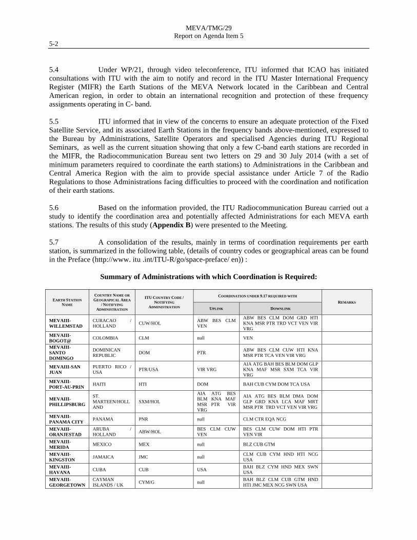
5-2 5.4 Under WP/21, through video teleconference, ITU informed that ICAO has initiated consultations with ITU with the aim to notify and record in the ITU Master International Frequency Register (MIFR) the Earth Stations of the MEVA Network located in the Caribbean and Central American region, in order to obtain an international recognition and protection of these frequency assignments operating in C- band. 5.5 ITU informed that in view of the concerns to ensure an adequate protection of the Fixed Satellite Service, and its associated Earth Stations in the frequency bands above-mentioned, expressed to the Bureau by Administrations, Satellite Operators and specialised Agencies during ITU Regional Seminars, as well as the current situation showing that only a few C-band earth stations are recorded in the MIFR, the Radiocommunication Bureau sent two letters on 29 and 30 July 2014 (with a set of minimum parameters required to coordinate the earth stations) to Administrations in the Caribbean and Central America Region with the aim to provide special assistance under Article 7 of the Radio Regulations to those Administrations facing difficulties to proceed with the coordination and notification of their earth stations. 5.6 Based on the information provided, the ITU Radiocommunication Bureau carried out a study to identify the coordination area and potentially affected Administrations for each MEVA earth stations. The results of this study (Appendix B) were presented to the Meeting. 5.7 A consolidation of the results, mainly in terms of coordination requirements per earth station, is summarized in the following table, (details of country codes or geographical areas can be found in the Preface (http://www. itu .int/ITU-R/go/space-preface/ en)) :
Summary of Administrations with which Coordination is Required:
EARTH STATION
NAME
COUNTRY NAME OR
GEOGRAPICAL AREA
/ NOTIFYING
ADMINISTRATION
ITU COUNTRY CODE / NOTIFYING
ADMINISTRATION
COORDINATION UNDER 9.17 REQUIRED WITH
REMARKS
UPLINK DOWNLINK
MEVAIII-WILLEMSTAD
CURACAO / HOLLAND
CUW/HOL ABW BES CLM VEN
ABW BES CLM DOM GRD HTI KNA MSR PTR TRD VCT VEN VIR VRG
MEVAIII-BOGOT@
COLOMBIA CLM null VEN
MEVAIII-SANTO DOMINGO
DOMINICAN REPUBLIC
DOM PTR ABW BES CLM CUW HTI KNA MSR PTR TCA VEN VIR VRG
MEVAIII-SAN JUAN
PUERTO RICO / USA
PTR/USA VIR VRG AIA ATG BAH BES BLM DOM GLP KNA MAF MSR SXM TCA VIR VRG
MEVAIII-PORT-AU-PRIN
HAITI HTI DOM BAH CUB CYM DOM TCA USA
MEVAIII-PHILLIPSBURG
ST. MARTEEN/HOLLAND
SXM/HOL
AIA ATG BES BLM KNA MAF MSR PTR VIR VRG
AIA ATG BES BLM DMA DOM GLP GRD KNA LCA MAF MRT MSR PTR TRD VCT VEN VIR VRG
MEVAIII-PANAMA CITY
PANAMA PNR null CLM CTR EQA NCG
MEVAIII-ORANJESTAD
ARUBA / HOLLAND
ABW/HOL BES CLM CUW VEN
BES CLM CUW DOM HTI PTR VEN VIR
MEVAIII-MERIDA
MEXICO MEX null BLZ CUB GTM
MEVAIII-KINGSTON
JAMAICA JMC null CLM CUB CYM HND HTI NCG USA
MEVAIII-HAVANA
CUBA CUB USA BAH BLZ CYM HND MEX SWN USA
MEVAIII-GEORGETOWN
CAYMAN ISLANDS / UK
CYM/G null BAH BLZ CLM CUB GTM HND HTI JMC MEX NCG SWN USA
MEVA/TMG/29 Report on Agenda Item 5
5-3 MEVAIII-NASSAU
BAHAMAS BAH null CUB DOM HTI TCA USA
MEVAIII-FREEPORT
BAHAMAS BAH USA CUB TCA USA
MEVAIII-COCESNA
HONDURAS HND NCG SLV BLZ CTR GTM NCG SLV coordinates to be confirmed by ICAO
MEVAIII-CARACAS
VENEZUELA VEN BES ABW BES BRB CLM CUW DMA DOM GLP GRD KNA LCA MRT MSR PTR TRD VCT VIR
MEVAIII-ATLANTA
USA USA null null
5.8 ITU presented the suggested 3 follow-up steps to facilitate the process of coordination and notification of the involved earth stations:
a) collect all the necessary parameters associated to the earth stations and associated satellite networks based on Appendix 4 of the Radio Regulations;
b) identify coordination requirements and to complete coordination among
concerned Administrations; and c) for Administrations having jurisdiction over the earth stations, to notify the earth
stations to ITU. 5.9 For all three above steps, administrations may request the assistance of the Radiocommunication Bureau. 5.10 The Meeting thanks ITU for their support on the registration of the VSAT nodes and expressed their support to the ICAO Position including the protection of the C-Band considering the lack of decision by Caribbean States and the need to register the VSAT Nodes and agreed on the following conclusion: CONCLUSION MEVA TMG/29/15 – MEVA MEMBER´s SUPPORT FOR ICAO WRC-2015 POSITION
AND ITU VSAT NODE REGISTRATION
That in order to protect the use of the radiofrequency spectrum for aviation usage and the timely MEVA III VSAT Node registration in ITU Master International Frequency Register (MIFR), the MEVA Members: a) Coordinate with their National Spectrum Regulators, the support to be provided
to the ICAO WRC-2015 Position for the upcoming CITEL Meetings in February 2015 (Medellin: (XXV PCC.II) and August 2015 (Ottawa: (XXVI PCC.II));
b) Using the ITU study carried out for the MEVA III Network (appendix B),
coordinate with their National Spectrum Regulators the corresponding MEVA III Node registration into MIFR; and
c) Report the progress of action a) and b) by MEVA TMG/30 Meeting.
MEVA/TMG/29 Report on Agenda Item 6
6-1 Agenda Item 6 Review of MEVA/TMG Terms of Reference (ToRs) and Work Programme 6.1 Under WP/16, the Meeting reviewed and approved an update to the MEVA III TMG Terms of Reference and Work Program, to include changes on:
Radio frequency managements and support by the TMG air navigation regional priorities and targets related to the MEVA Network
infrastructure that were developed by the NAM/CAR Air Navigation Implementation Working Group (ANI/WG) and approved by the NAM/CAR Directors of Civil Aviation.
6.2 The updated MEVA III TMG Terms of Reference and Work Program are presented in Appendix C. In this regard the following conclusion was agreed: CONCLUSION MEVA TMG/29/16 APPROVAL OF MEVA TMG TERMS OF REFERENCE
That in order to maintain the functions and responsibilities of the MEVA TMG up-to-date, the attached MEVA TMG Terms of Reference shown in the Appendix C was approved.
MEVA/TMG/29 Report on Agenda Item 7
7-1 Agenda Item 7 Other Matters
7.1 Aviation System Block Upgrade (ASBU) Implementation and Support review
7.1.1 Under WP/17, the Secretariat presented an overview of the Aviation System Block Upgrade (ASBU) methodology adopted under the NAM/CAR Regional Performance based Air navigation Implementation Plan for the Group consideration and recalled:
the conclusion MEVA TMG 26/20 - MEVA TMG Support for ANI/WG Activities and
the air navigation regional priorities and targets related to the MEVA Network infrastructure that were developed by the NAM/CAR ANI/WG and approved by the NAM/CAR Directors of Civil Aviation, presented at the MVA TMG/28
7.1.2 The Meeting noted that eventually for 2015, the RPBANIP content will be migrated to the Volume III of the electronic Regional Air Navigation Plan (eANP) and that the ANI/WG/02 Meeting will be held in Costa Rica in June 2015. 7.1.3 The Meeting concurred that the accomplished update of the existing work programme and Terms of Reference made in Agenda Item 6 was now aligned to the RPBANIP and ASBU methodology. In this regard the following conclusion was agreed: CONCLUSION MEVA TMG/29/17 MEVA TMG SUPPORT FOR ANIWG/02 MEETING
That in order to ensure active participation by MEVA Members at the ANIWG/02 Meeting and appropriate preparation of the MEVA III progress, the MEVA TMG Coordinator coordinate and develop the corresponding working paper for the ANIWG/02 Meeting describing the progress in MEVA III Implementation and the support of the MEVA Network to Air navigation in the regions
7.2 MEVA III Go-teams
7.2.1 Under WP/18, the Meeting followed up the implementation of the MEVA III Go-Teams as proposed in the MEVA TMG/28 Meeting and recalled that the MEVA III Go-Team initiative was well accepted by the MEVA Members including the work framework of a Go-Team and proposed the development of the MEVA III Go-Team to assist the SAT execution, as established in CONCLUSION MEVA TMG/28/15 MEVA III GO – TEAMS, recognizing that with the new approach of the SAT including some NAT activities, the importance of the assistance of the MEVA III Go-teams have increase ensuring operation and configuration consistency, as well as reducing the operational risk for the final network cutover from MEVA II to MEVA III. 7.2.2 The MEVA III GoTeam Revised Terms of Reference were presented as shown in Appendix D. The Meeting was informed of a tentative schedule of these Go-Teams based on the MEVA III Implementation schedule version 5.6; however the Meeting noted that the dates were updated in accordance to the new update of the implementation schedule by Comsoft (Appendix E).
MEVA/TMG/29 Report on Agenda Item 7
7-2 7.2.3 The Meeting took noted that COCESNA, Cuba and Jamaica had already designated their MEVA III Subject Matter experts (SMES) to participate in the Goteams. 7.2.4 Based on the above, the RLA/09/801 Project and MEVA Members agreed on the following conclusion: CONCLUSION MEVA TMG/29/18 ACCEPTANCE OF THE MEVA III GO-TEAM MISSIONS AND
SME DESIGNATION
That, in order to comply with the MEVA III implementation dates, MEVA III Network Members who are part of the RLA/09/801 Project: a) hereby accept the Go-Team MEVA III Mission visits that will be carried out as
detailed in the tentative schedule for MEVA III Go-Team Missions; and
b) designate subject matter experts (SME) to support these Go-Team missions in accordance with the designation given in the tentative schedule for MEVA III Go-Team Missions
7.3 Next MEVA/TMG Meeting Preparations
7.3.1 Under WP/19, The Meeting recognized that the TMG Meetings are the unique opportunity for the annual evaluation of the MEVA network performance and the MEVA Members to solve collective problems and seek collaboration for expanding mutual support for enhancing the telecommunications services in the region. Also that the annual MEVA/TMG meetings have proven to be very productive and effective, for keeping the network service performance, the interoperability matters with other networks, shared lessons learned among the MEVA Members, the implementation of failure reporting features; facilitate coordination on new services implementation and to establish awareness and conscience on the network health, changes and expansion. 7.3.2 The MEVA TMG/28 Meeting held at Miami, United States, close to the equipment facilities of the Regional representative of COMSOFT, NewComm, demonstrated the benefit of combining some of the Network discussion with onsite experiences visiting the equipment and facilities of the MEVA Network, serving as well as an opportunity to exchange practical experiences of the facilities where the MEVA Equipment operates. 7.3.3 With this same approach the next MEVA TMG Meeting, TMG/30, will be carried out in from 27 to 29 May 2015 in Aruba, being this the first operational meeting under the MEVA III Network operations. This TMG Meeting will be done after the first MEVAIII- REDDIG II Coordination Meeting (25-26 May 2015) also in Aruba. 7.3.4 In this regard a TMG meetings rotation schedule was agreed by the MEVA Members with the following considerations:
Each of the TMG Meeting shall also be combined with other subject related
meetings under the same week to enhance the benefits of the face-to face meetings.
MEVA/TMG/29 Report on Agenda Item 7
7-3
For these meetings, the participation of ICAO is to be funded by the hosting MEVA State/entity member.
Notwithstanding the annual meetings, periodic teleconferences hosted by ICAO in coordination with the MEVA TMG Coordinator will continue as deem necessary.
7.3.5 The final MEVA TMG meeting rotational schedule is shown in the Appendix F. The MEVA TMG meeting rotation schedule shall be incorporated into the MEVA TMG terms of reference. In this regard the following conclusion was formulated: CONCLUSION MEVA TMG/29/19 – MEVA TMG MEETING ROTATIONAL SCHEME
That in order to improve the planning and organize of the MEVA TMG Meetings taking in consideration the benefits of conducting the meetings in MEVA locations, the MEVA Members: a) Approve the MEVA TMG Meeting Rotational scheme as shown in Appendix F;
and b) Confirm the hosting of the MEVA TMG Meeting by the next MEVA TMG/30
Meeting.

MEVA/TMG/29
APPENDIX A FOLLOW-UP TO VALID CONCLUSIONS FROM THE MEVA TMG/28 MEETING
Conclusion Description Remarks Status 28/01 - SES PENDING ACTION FOR COMPLETING AMRT/MRT ASSESSMENT AND REMOTE RADIO CIRCUIT IMPLEMENTATION
That, in order to complete the pending implementation/operational actions to ensure the safety and efficient operation of the MEVA II Network, SES: a) Complete the AMRT/MRT switching testing, no later than 30 June 2014; and b) Complete the implementation of the remote radio circuit, 20 June 2014.
AMRT/MRT activities were conducted by SES
Completed
28/02 - COMPLETION OF MEVA/REDDIG INTERCONNECTION AFTN DATA CIRCUIT WITH BRAZIL
That United States and the ICAO NACC Regional Office request assistance from the REDDIG Administrator by 3 June 2014, for coordination with Brazil to complete final testing of AFTN data circuit Atlanta-Manaus.
This interconnection is still pending and due to the closeness of the MEVA III implementation and the Moratorium with United States, it was agreed to continue the efforts for MEVA III
Superseded
28/03 - MEXICO TO SIGN MEVA III DOCUMENT OF AGREEMENT
That for the complete signing of the MEVA III DoA and common MEVA III contracting aspects, Mexico signs the MEVA III DoA by 30 June 2013, submitting the signed DoA to ICAO.
Mexico signed the MEVA III DOA on 12 Dec 2014
completed
28/04 - MEVA II AVAILABILITY CLAIM
That, in order to report the service outage and unavailability noted in the network in the first 5 months of 2014, MEVA Members: a) The MEVA TF (Cuba and Jamaica) to propose no later than June 3, a format for recollecting the minimum sufficient data for determining the service unavailability; b) MEVA Members following the format defined in letter a) recollect the data from 1 January to 31 May 2014 sending it to ICAO no later than 20 June; and c) ICAO to submit ,by 30 June. to SES the MEVA Members´ unavailability information for their response and subsequent actions
These activities were conducted. A State letter was submitted and the results were shared will all MEVA Members for their respective claims.
Completed
28/05- SES CONFIRMATION OF EQUIPMENT OWNERSHIP
That, in order to ensure which equipment is owned by the MEVA Members and which to SES, SES confirm no later than 6 June, the correctness of the preliminary ownership table shown in the TMG/28 report.
SES confirmed ownership.
Completed
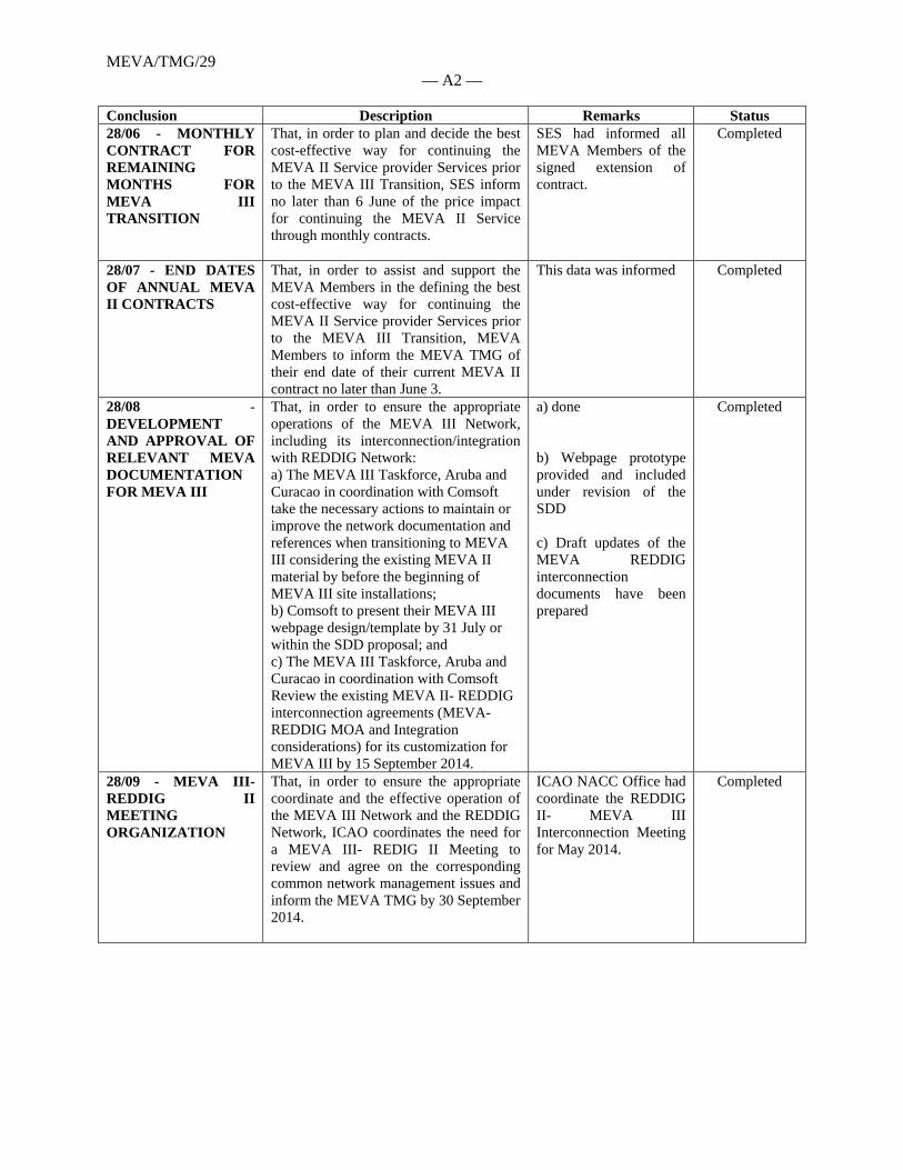
MEVA/TMG/29 — A2 —
Conclusion Description Remarks Status 28/06 - MONTHLY CONTRACT FOR REMAINING MONTHS FOR MEVA III TRANSITION
That, in order to plan and decide the best cost-effective way for continuing the MEVA II Service provider Services prior to the MEVA III Transition, SES inform no later than 6 June of the price impact for continuing the MEVA II Service through monthly contracts.
SES had informed all MEVA Members of the signed extension of contract.
Completed
28/07 - END DATES OF ANNUAL MEVA II CONTRACTS
That, in order to assist and support the MEVA Members in the defining the best cost-effective way for continuing the MEVA II Service provider Services prior to the MEVA III Transition, MEVA Members to inform the MEVA TMG of their end date of their current MEVA II contract no later than June 3.
This data was informed Completed
28/08 - DEVELOPMENT AND APPROVAL OF RELEVANT MEVA DOCUMENTATION FOR MEVA III
That, in order to ensure the appropriate operations of the MEVA III Network, including its interconnection/integration with REDDIG Network: a) The MEVA III Taskforce, Aruba and Curacao in coordination with Comsoft take the necessary actions to maintain or improve the network documentation and references when transitioning to MEVA III considering the existing MEVA II material by before the beginning of MEVA III site installations; b) Comsoft to present their MEVA III webpage design/template by 31 July or within the SDD proposal; and c) The MEVA III Taskforce, Aruba and Curacao in coordination with Comsoft Review the existing MEVA II- REDDIG interconnection agreements (MEVA-REDDIG MOA and Integration considerations) for its customization for MEVA III by 15 September 2014.
a) done b) Webpage prototype provided and included under revision of the SDD c) Draft updates of the MEVA REDDIG interconnection documents have been prepared
Completed
28/09 - MEVA III- REDDIG II MEETING ORGANIZATION
That, in order to ensure the appropriate coordinate and the effective operation of the MEVA III Network and the REDDIG Network, ICAO coordinates the need for a MEVA III- REDIG II Meeting to review and agree on the corresponding common network management issues and inform the MEVA TMG by 30 September 2014.
ICAO NACC Office had coordinate the REDDIG II- MEVA III Interconnection Meeting for May 2014.
Completed
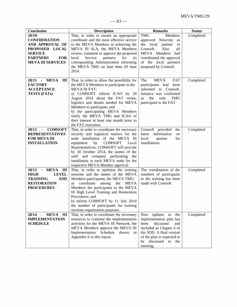
MEVA/TMG/29 — A3 —
Conclusion Description Remarks Status 28/10- CONFIRMATION AND APPROVAL OF PROPOSED LOCAL SERVICE PARTNERS FOR MEVA III SERVICES
That, in order to ensure an appropriate coordinate and the most effective service to the MEVA Members in achieving the MEVA III SLA, the MEVA Members review, comment or approve the proposed local Service partners for its corresponding Administration informing the MEVA TMG no later than 20 June 2014.
TMG Members approved Newcom as the local partner to Comsoft. Also all MEVA Members had coordinated the approval of the local partners proposed by Comsoft
Completed
28/11 - MEVA III FACTORY ACCEPTANCE TESTS (FATs)
That, in order to allow the possibility for the MEVA Members to participate in the MEVA III FAT: a) COMSOFT inform ICAO by 29 August 2014 about the FAT venue, logistics and details needed for MEVA Members to participate; and b) the participating MEVA Members notify the MEVA TMG and ICAO of their interest at least one month prior to the FAT execution.
The MEVA FAT participants had been informed to Comsoft. Jamaica was confirmed as the only TMG participant to the FAT.
Completed
28/12 - COMSOFT REPRESENTATIVES FOR MEVA III INSTALLATION
That, in order to coordinate the necessary security and logistical matters for the node installation of the MEVA III equipment by COMSOFT Local Representatives, COMSOFT will provide by 30 October 2014, the names of the staff and company performing the installation in each MEVA node for the respective MEVA Member approval.
Comsoft provided the latest information on local partner for installations
Completed
28/13 - MEVA III HIGH LEVEL TRAINING AND RESTORATION PROCEDURES
That, in order to optimize the training sessions and the names of the MEVA Members participants, the MEVA TMG: a) coordinate among the MEVA Members the participants to the MEVA III High Level Training and Restoration Procedures; and b) inform COMSOFT by 11 July 2014 the number of participants for training sessions organization purposes.
The coordination of the numbers of participants to the training has been made with Comsoft
Completed
28/14 - MEVA III IMPLEMENTATION SCHEDULE
That, in order to coordinate the necessary resources to continue the implementation activities for the MEVA III Network, the MEVA Members approve the MEVA III Implementation Schedule shown in Appendix E to this report.
New updates to the implementation plan has been discussed and included as Chapter 6 of the SDD. A final version of the plan is expected to be discussed in the meeting.
Completed
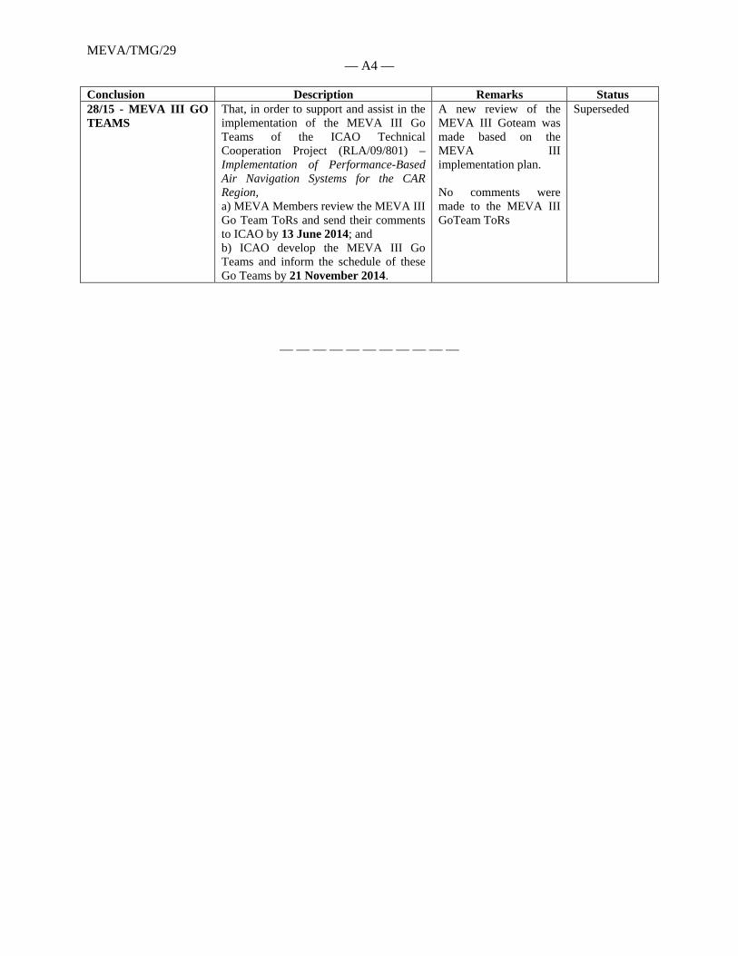
MEVA/TMG/29 — A4 —
Conclusion Description Remarks Status 28/15 - MEVA III GO TEAMS
That, in order to support and assist in the implementation of the MEVA III Go Teams of the ICAO Technical Cooperation Project (RLA/09/801) – Implementation of Performance-Based Air Navigation Systems for the CAR Region, a) MEVA Members review the MEVA III Go Team ToRs and send their comments to ICAO by 13 June 2014; and b) ICAO develop the MEVA III Go Teams and inform the schedule of these Go Teams by 21 November 2014.
A new review of the MEVA III Goteam was made based on the MEVA III implementation plan. No comments were made to the MEVA III GoTeam ToRs
Superseded
— — — — — — — — — — —
APPENDIX B
EARTH STATIONS COORDINATION CONTOURS ASSOCIATED TO ICAO MEVA III
VSATs NETWORK LOCATED IN THE CARIBBEAN AND CENTRAL AMERICAN REGION
This annex contains the analysis carried out by the Radiocommunication Bureau based on the
criteria and methodology described in the Appendix 7 to the ITU Radio Regulations for the
determination of the coordination area around an earth station and the identification of potentially
affected countries which shall be involved in the coordination process between transmiting or
receiving earth stations in the Fixed Satellite Service sharing the frequency band with fixed or
mobile terrestrial services with equal rights in terms of frequency allocation.
The list of earth stations included in this annex associated to the Satellite Network USASAT-60I
located at 45 degrees west and its assigned frequencies 6064.75 MHz in the uplink and 3839.75
MHz in the downlink is described below:
Earth Station Name Country Name or Geograpical Area / Notifying Administration
ITU Country Code / Notifying Administration
MEVAIII-WILLEMSTAD CURACAO / HOLLAND CUW/HOL
MEVAIII-BOGOT@ COLOMBIA CLM
MEVAIII-SANTO DOMINGO DOMINICAN REPUBLIC DOM
MEVAIII-SAN JUAN PUERTO RICO / USA PTR/USA
MEVAIII-PORT-AU-PRIN HAITI HTI
MEVAIII-PHILLIPSBURG St. MARTEEN/HOLLAND SXM/HOL
MEVAIII-PANAMA CITY PANAMA PNR
MEVAIII-ORANJESTAD ARUBA / HOLLAND ABW/HOL
MEVAIII-MERIDA MEXICO MEX
MEVAIII-KINGSTON JAMAICA JMC
MEVAIII-HAVANA CUBA CUB
MEVAIII-GEORGETOWN CAYMAN ISLANDS / UK CYM/G
MEVAIII-NASSAU BAHAMAS BAH
MEVAIII-FREEPORT BAHAMAS BAH
MEVAIII-COCESNA HONDURAS HND
MEVAIII-CARACAS VENEZUELA VEN
MEVAIII-ATLANTA USA USA
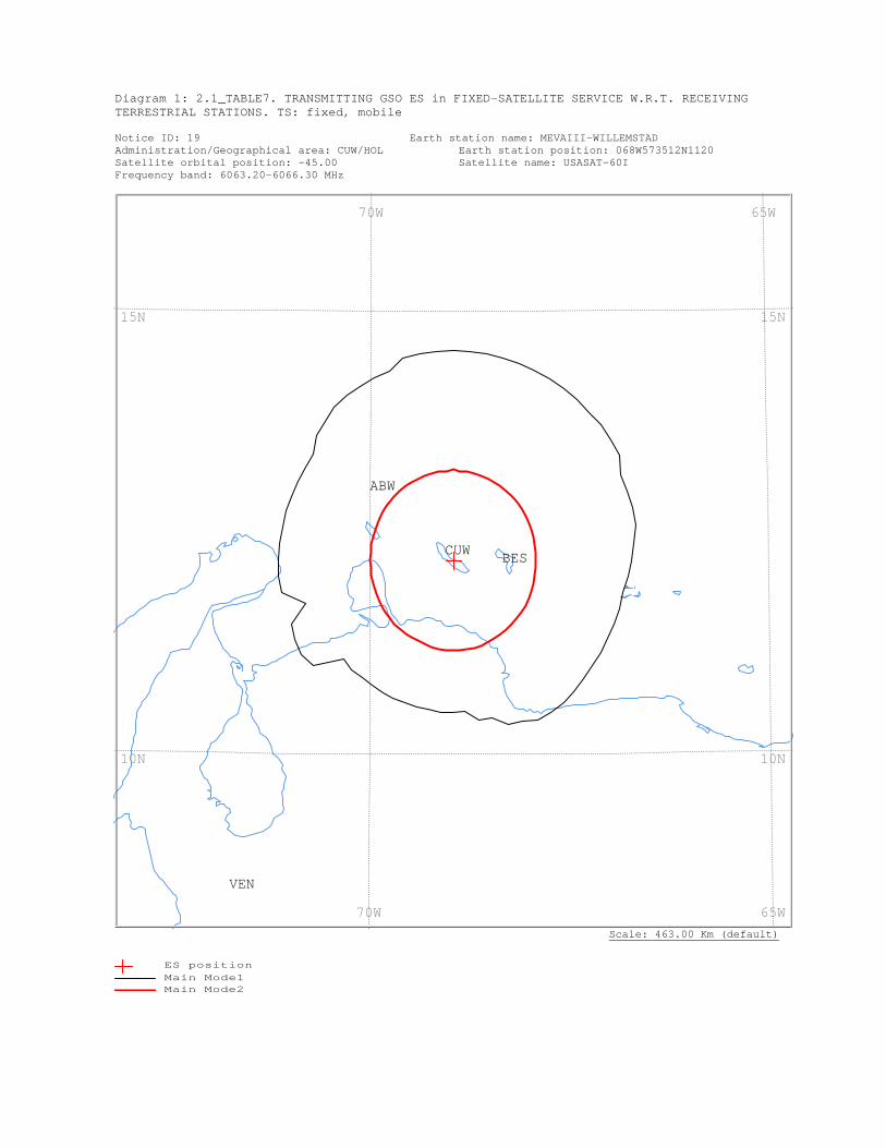
Diagram 1: 2.1_TABLE7. TRANSMITTING GSO ES in FIXED-SATELLITE SERVICE W.R.T. RECEIVING TERRESTRIAL STATIONS. TS: fixed, mobile Notice ID: 19 Earth station name: MEVAIII-WILLEMSTAD Administration/Geographical area: CUW/HOL Earth station position: 068W573512N1120 Satellite orbital position: -45.00 Satellite name: USASAT-60I Frequency band: 6063.20-6066.30 MHz
Scale: 463.00 Km (default)
VEN
CUW BES
ABW
65W 70W
65W 70W
15N
10N
15N
10N
ES positionMain Mode1 Main Mode2
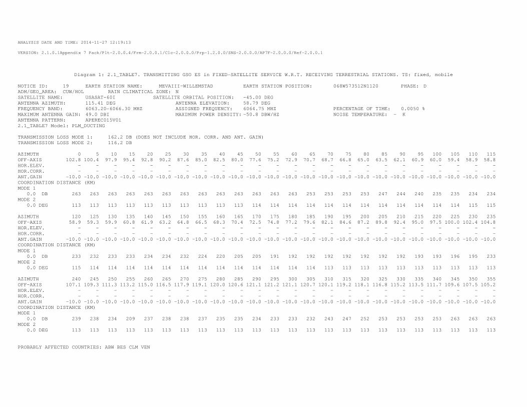
ANALYSIS DATE AND TIME: 2014-11-27 12:19:13
VERSION: 2.1.0.1Appendix 7 Pack/Plt-2.0.0.4/Frm-2.0.0.1/Clc-2.0.0.0/Prp-1.2.0.0/SNS-2.0.0.0/AP7F-2.0.0.0/Ref-2.0.0.1
Diagram 1: 2.1_TABLE7. TRANSMITTING GSO ES in FIXED-SATELLITE SERVICE W.R.T. RECEIVING TERRESTRIAL STATIONS. TS: fixed, mobile
NOTICE ID: 19 EARTH STATION NAME: MEVAIII-WILLEMSTAD EARTH STATION POSITION: 068W573512N1120 PHASE: D ADM/GEO_AREA: CUW/HOL RAIN CLIMATICAL ZONE: N SATELLITE NAME: USASAT-60I SATELLITE ORBITAL POSITION: -45.00 DEG ANTENNA AZIMUTH: 115.41 DEG ANTENNA ELEVATION: 58.79 DEG FREQUENCY BAND: 6063.20-6066.30 MHZ ASSIGNED FREQUENCY: 6064.75 MHZ PERCENTAGE OF TIME: 0.0050 % MAXIMUM ANTENNA GAIN: 49.0 DBI MAXIMUM POWER DENSITY: -50.8 DBW/HZ NOISE TEMPERATURE: - K ANTENNA PATTERN: APEREC015V01 2.1_TABLE7 Model: PLM_DUCTING TRANSMISSION LOSS MODE 1: 162.2 DB (DOES NOT INCLUDE HOR. CORR. AND ANT. GAIN) TRANSMISSION LOSS MODE 2: 116.2 DB AZIMUTH 0 5 10 15 20 25 30 35 40 45 50 55 60 65 70 75 80 85 90 95 100 105 110 115 OFF-AXIS 102.8 100.4 97.9 95.4 92.8 90.2 87.6 85.0 82.5 80.0 77.6 75.2 72.9 70.7 68.7 66.8 65.0 63.5 62.1 60.9 60.0 59.4 58.9 58.8 HOR.ELEV. - - - - - - - - - - - - - - - - - - - - - - - - HOR.CORR. - - - - - - - - - - - - - - - - - - - - - - - - ANT.GAIN -10.0 -10.0 -10.0 -10.0 -10.0 -10.0 -10.0 -10.0 -10.0 -10.0 -10.0 -10.0 -10.0 -10.0 -10.0 -10.0 -10.0 -10.0 -10.0 -10.0 -10.0 -10.0 -10.0 -10.0 COORDINATION DISTANCE (KM) MODE 1 0.0 DB 263 263 263 263 263 263 263 263 263 263 263 263 263 253 253 253 253 247 244 240 235 235 234 234 MODE 2 0.0 DEG 113 113 113 113 113 113 113 113 113 113 114 114 114 114 114 114 114 114 114 114 114 114 115 115 AZIMUTH 120 125 130 135 140 145 150 155 160 165 170 175 180 185 190 195 200 205 210 215 220 225 230 235 OFF-AXIS 58.9 59.3 59.9 60.8 61.9 63.2 64.8 66.5 68.3 70.4 72.5 74.8 77.2 79.6 82.1 84.6 87.2 89.8 92.4 95.0 97.5 100.0 102.4 104.8 HOR.ELEV. - - - - - - - - - - - - - - - - - - - - - - - - HOR.CORR. - - - - - - - - - - - - - - - - - - - - - - - - ANT.GAIN -10.0 -10.0 -10.0 -10.0 -10.0 -10.0 -10.0 -10.0 -10.0 -10.0 -10.0 -10.0 -10.0 -10.0 -10.0 -10.0 -10.0 -10.0 -10.0 -10.0 -10.0 -10.0 -10.0 -10.0 COORDINATION DISTANCE (KM) MODE 1 0.0 DB 233 232 233 233 234 234 232 224 220 205 205 191 192 192 192 192 192 192 192 193 193 196 195 233 MODE 2 0.0 DEG 115 114 114 114 114 114 114 114 114 114 114 114 114 114 113 113 113 113 113 113 113 113 113 113 AZIMUTH 240 245 250 255 260 265 270 275 280 285 290 295 300 305 310 315 320 325 330 335 340 345 350 355 OFF-AXIS 107.1 109.3 111.3 113.2 115.0 116.5 117.9 119.1 120.0 120.6 121.1 121.2 121.1 120.7 120.1 119.2 118.1 116.8 115.2 113.5 111.7 109.6 107.5 105.2 HOR.ELEV. - - - - - - - - - - - - - - - - - - - - - - - - HOR.CORR. - - - - - - - - - - - - - - - - - - - - - - - - ANT.GAIN -10.0 -10.0 -10.0 -10.0 -10.0 -10.0 -10.0 -10.0 -10.0 -10.0 -10.0 -10.0 -10.0 -10.0 -10.0 -10.0 -10.0 -10.0 -10.0 -10.0 -10.0 -10.0 -10.0 -10.0 COORDINATION DISTANCE (KM) MODE 1 0.0 DB 239 238 234 209 237 238 238 237 235 235 234 233 233 232 243 247 252 253 253 253 253 263 263 263 MODE 2 0.0 DEG 113 113 113 113 113 113 113 113 113 113 113 113 113 113 113 113 113 113 113 113 113 113 113 113 PROBABLY AFFECTED COUNTRIES: ABW BES CLM VEN
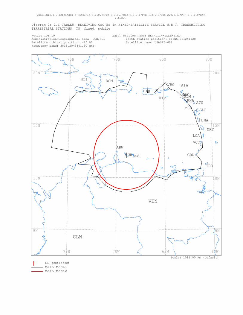
VERSION:2.1.0.1Appendix 7 Pack/Plt-2.0.0.4/Frm-2.0.0.1/Clc-2.0.0.0/Prp-1.2.0.0/SNS-2.0.0.0/AP7F-2.0.0.0/Ref-2.0.0.1
Diagram 2: 2.1_TABLE8. RECEIVING GSO ES in FIXED-SATELLITE SERVICE W.R.T. TRANSMITTING TERRESTRIAL STATIONS. TS: fixed, mobile Notice ID: 19 Earth station name: MEVAIII-WILLEMSTAD Administration/Geographical area: CUW/HOL Earth station position: 068W573512N1120 Satellite orbital position: -45.00 Satellite name: USASAT-60I Frequency band: 3838.20-3841.30 MHz
Scale: 1084.00 Km (default)
VRG
VIR
VEN
VCT
TRD
SXMPTR
MSR
MRT
MAF
LCA
KNA
HTI
GRD
GLP
DOM
DMA
CUW
CLM
BLM
BES
ATG
AIA
ABW
60W 65W 70W 75W
60W 65W 70W 75W
20N
15N
10N
5N
20N
15N
10N
5N
ES positionMain Mode1 Main Mode2
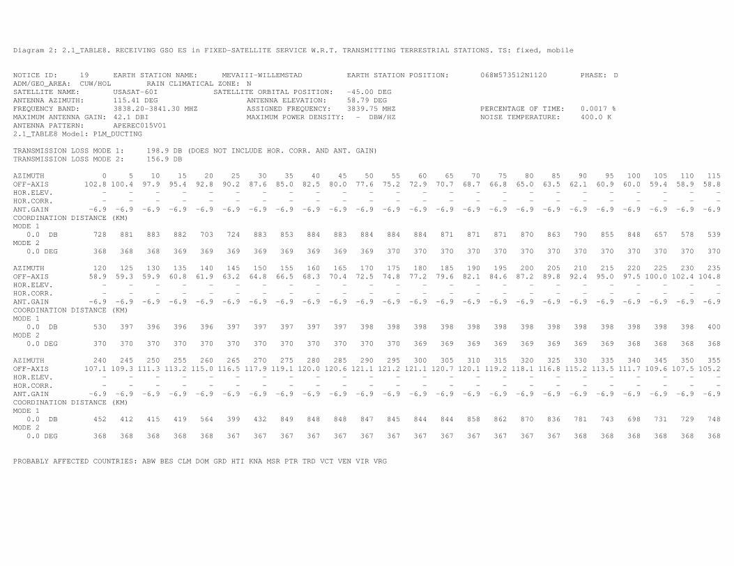
Diagram 2: 2.1_TABLE8. RECEIVING GSO ES in FIXED-SATELLITE SERVICE W.R.T. TRANSMITTING TERRESTRIAL STATIONS. TS: fixed, mobile
NOTICE ID: 19 EARTH STATION NAME: MEVAIII-WILLEMSTAD EARTH STATION POSITION: 068W573512N1120 PHASE: D ADM/GEO_AREA: CUW/HOL RAIN CLIMATICAL ZONE: N SATELLITE NAME: USASAT-60I SATELLITE ORBITAL POSITION: -45.00 DEG ANTENNA AZIMUTH: 115.41 DEG ANTENNA ELEVATION: 58.79 DEG FREQUENCY BAND: 3838.20-3841.30 MHZ ASSIGNED FREQUENCY: 3839.75 MHZ PERCENTAGE OF TIME: 0.0017 % MAXIMUM ANTENNA GAIN: 42.1 DBI MAXIMUM POWER DENSITY: - DBW/HZ NOISE TEMPERATURE: 400.0 K ANTENNA PATTERN: APEREC015V01 2.1_TABLE8 Model: PLM_DUCTING TRANSMISSION LOSS MODE 1: 198.9 DB (DOES NOT INCLUDE HOR. CORR. AND ANT. GAIN) TRANSMISSION LOSS MODE 2: 156.9 DB AZIMUTH 0 5 10 15 20 25 30 35 40 45 50 55 60 65 70 75 80 85 90 95 100 105 110 115 OFF-AXIS 102.8 100.4 97.9 95.4 92.8 90.2 87.6 85.0 82.5 80.0 77.6 75.2 72.9 70.7 68.7 66.8 65.0 63.5 62.1 60.9 60.0 59.4 58.9 58.8 HOR.ELEV. - - - - - - - - - - - - - - - - - - - - - - - - HOR.CORR. - - - - - - - - - - - - - - - - - - - - - - - - ANT.GAIN -6.9 -6.9 -6.9 -6.9 -6.9 -6.9 -6.9 -6.9 -6.9 -6.9 -6.9 -6.9 -6.9 -6.9 -6.9 -6.9 -6.9 -6.9 -6.9 -6.9 -6.9 -6.9 -6.9 -6.9 COORDINATION DISTANCE (KM) MODE 1 0.0 DB 728 881 883 882 703 724 883 853 884 883 884 884 884 871 871 871 870 863 790 855 848 657 578 539 MODE 2 0.0 DEG 368 368 368 369 369 369 369 369 369 369 369 370 370 370 370 370 370 370 370 370 370 370 370 370 AZIMUTH 120 125 130 135 140 145 150 155 160 165 170 175 180 185 190 195 200 205 210 215 220 225 230 235 OFF-AXIS 58.9 59.3 59.9 60.8 61.9 63.2 64.8 66.5 68.3 70.4 72.5 74.8 77.2 79.6 82.1 84.6 87.2 89.8 92.4 95.0 97.5 100.0 102.4 104.8 HOR.ELEV. - - - - - - - - - - - - - - - - - - - - - - - - HOR.CORR. - - - - - - - - - - - - - - - - - - - - - - - - ANT.GAIN -6.9 -6.9 -6.9 -6.9 -6.9 -6.9 -6.9 -6.9 -6.9 -6.9 -6.9 -6.9 -6.9 -6.9 -6.9 -6.9 -6.9 -6.9 -6.9 -6.9 -6.9 -6.9 -6.9 -6.9 COORDINATION DISTANCE (KM) MODE 1 0.0 DB 530 397 396 396 396 397 397 397 397 397 398 398 398 398 398 398 398 398 398 398 398 398 398 400 MODE 2 0.0 DEG 370 370 370 370 370 370 370 370 370 370 370 370 369 369 369 369 369 369 369 369 368 368 368 368 AZIMUTH 240 245 250 255 260 265 270 275 280 285 290 295 300 305 310 315 320 325 330 335 340 345 350 355 OFF-AXIS 107.1 109.3 111.3 113.2 115.0 116.5 117.9 119.1 120.0 120.6 121.1 121.2 121.1 120.7 120.1 119.2 118.1 116.8 115.2 113.5 111.7 109.6 107.5 105.2 HOR.ELEV. - - - - - - - - - - - - - - - - - - - - - - - - HOR.CORR. - - - - - - - - - - - - - - - - - - - - - - - - ANT.GAIN -6.9 -6.9 -6.9 -6.9 -6.9 -6.9 -6.9 -6.9 -6.9 -6.9 -6.9 -6.9 -6.9 -6.9 -6.9 -6.9 -6.9 -6.9 -6.9 -6.9 -6.9 -6.9 -6.9 -6.9 COORDINATION DISTANCE (KM) MODE 1 0.0 DB 452 412 415 419 564 399 432 849 848 848 847 845 844 844 858 862 870 836 781 743 698 731 729 748 MODE 2 0.0 DEG 368 368 368 368 368 367 367 367 367 367 367 367 367 367 367 367 367 367 368 368 368 368 368 368 PROBABLY AFFECTED COUNTRIES: ABW BES CLM DOM GRD HTI KNA MSR PTR TRD VCT VEN VIR VRG
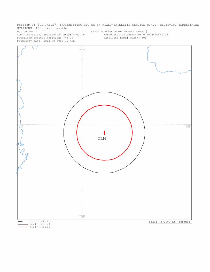
Diagram 1: 2.1_TABLE7. TRANSMITTING GSO ES in FIXED-SATELLITE SERVICE W.R.T. RECEIVING TERRESTRIAL STATIONS. TS: fixed, mobile Notice ID: 2 Earth station name: MEVAIII-BOGOT@ Administration/Geographical area: CLM/CLM Earth station position: 074W084904N4206 Satellite orbital position: -45.00 Satellite name: USASAT-60I Frequency band: 6063.20-6066.30 MHz
Scale: 373.00 Km (default)
CLM
75W
75W
5N5N
ES positionMain Mode1 Main Mode2
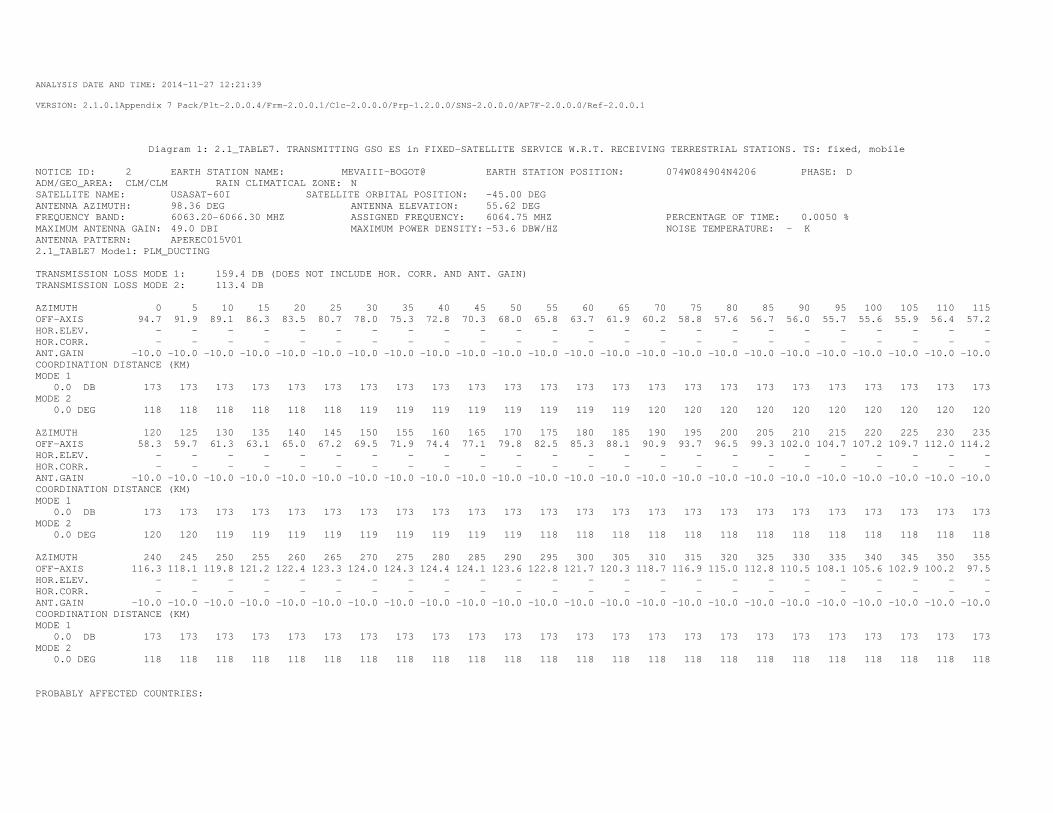
ANALYSIS DATE AND TIME: 2014-11-27 12:21:39
VERSION: 2.1.0.1Appendix 7 Pack/Plt-2.0.0.4/Frm-2.0.0.1/Clc-2.0.0.0/Prp-1.2.0.0/SNS-2.0.0.0/AP7F-2.0.0.0/Ref-2.0.0.1
Diagram 1: 2.1_TABLE7. TRANSMITTING GSO ES in FIXED-SATELLITE SERVICE W.R.T. RECEIVING TERRESTRIAL STATIONS. TS: fixed, mobile
NOTICE ID: 2 EARTH STATION NAME: MEVAIII-BOGOT@ EARTH STATION POSITION: 074W084904N4206 PHASE: D ADM/GEO_AREA: CLM/CLM RAIN CLIMATICAL ZONE: N SATELLITE NAME: USASAT-60I SATELLITE ORBITAL POSITION: -45.00 DEG ANTENNA AZIMUTH: 98.36 DEG ANTENNA ELEVATION: 55.62 DEG FREQUENCY BAND: 6063.20-6066.30 MHZ ASSIGNED FREQUENCY: 6064.75 MHZ PERCENTAGE OF TIME: 0.0050 % MAXIMUM ANTENNA GAIN: 49.0 DBI MAXIMUM POWER DENSITY: -53.6 DBW/HZ NOISE TEMPERATURE: - K ANTENNA PATTERN: APEREC015V01 2.1_TABLE7 Model: PLM_DUCTING TRANSMISSION LOSS MODE 1: 159.4 DB (DOES NOT INCLUDE HOR. CORR. AND ANT. GAIN) TRANSMISSION LOSS MODE 2: 113.4 DB AZIMUTH 0 5 10 15 20 25 30 35 40 45 50 55 60 65 70 75 80 85 90 95 100 105 110 115 OFF-AXIS 94.7 91.9 89.1 86.3 83.5 80.7 78.0 75.3 72.8 70.3 68.0 65.8 63.7 61.9 60.2 58.8 57.6 56.7 56.0 55.7 55.6 55.9 56.4 57.2 HOR.ELEV. - - - - - - - - - - - - - - - - - - - - - - - - HOR.CORR. - - - - - - - - - - - - - - - - - - - - - - - - ANT.GAIN -10.0 -10.0 -10.0 -10.0 -10.0 -10.0 -10.0 -10.0 -10.0 -10.0 -10.0 -10.0 -10.0 -10.0 -10.0 -10.0 -10.0 -10.0 -10.0 -10.0 -10.0 -10.0 -10.0 -10.0 COORDINATION DISTANCE (KM) MODE 1 0.0 DB 173 173 173 173 173 173 173 173 173 173 173 173 173 173 173 173 173 173 173 173 173 173 173 173 MODE 2 0.0 DEG 118 118 118 118 118 118 119 119 119 119 119 119 119 119 120 120 120 120 120 120 120 120 120 120 AZIMUTH 120 125 130 135 140 145 150 155 160 165 170 175 180 185 190 195 200 205 210 215 220 225 230 235 OFF-AXIS 58.3 59.7 61.3 63.1 65.0 67.2 69.5 71.9 74.4 77.1 79.8 82.5 85.3 88.1 90.9 93.7 96.5 99.3 102.0 104.7 107.2 109.7 112.0 114.2 HOR.ELEV. - - - - - - - - - - - - - - - - - - - - - - - - HOR.CORR. - - - - - - - - - - - - - - - - - - - - - - - - ANT.GAIN -10.0 -10.0 -10.0 -10.0 -10.0 -10.0 -10.0 -10.0 -10.0 -10.0 -10.0 -10.0 -10.0 -10.0 -10.0 -10.0 -10.0 -10.0 -10.0 -10.0 -10.0 -10.0 -10.0 -10.0 COORDINATION DISTANCE (KM) MODE 1 0.0 DB 173 173 173 173 173 173 173 173 173 173 173 173 173 173 173 173 173 173 173 173 173 173 173 173 MODE 2 0.0 DEG 120 120 119 119 119 119 119 119 119 119 119 118 118 118 118 118 118 118 118 118 118 118 118 118 AZIMUTH 240 245 250 255 260 265 270 275 280 285 290 295 300 305 310 315 320 325 330 335 340 345 350 355 OFF-AXIS 116.3 118.1 119.8 121.2 122.4 123.3 124.0 124.3 124.4 124.1 123.6 122.8 121.7 120.3 118.7 116.9 115.0 112.8 110.5 108.1 105.6 102.9 100.2 97.5 HOR.ELEV. - - - - - - - - - - - - - - - - - - - - - - - - HOR.CORR. - - - - - - - - - - - - - - - - - - - - - - - - ANT.GAIN -10.0 -10.0 -10.0 -10.0 -10.0 -10.0 -10.0 -10.0 -10.0 -10.0 -10.0 -10.0 -10.0 -10.0 -10.0 -10.0 -10.0 -10.0 -10.0 -10.0 -10.0 -10.0 -10.0 -10.0 COORDINATION DISTANCE (KM) MODE 1 0.0 DB 173 173 173 173 173 173 173 173 173 173 173 173 173 173 173 173 173 173 173 173 173 173 173 173 MODE 2 0.0 DEG 118 118 118 118 118 118 118 118 118 118 118 118 118 118 118 118 118 118 118 118 118 118 118 118 PROBABLY AFFECTED COUNTRIES:
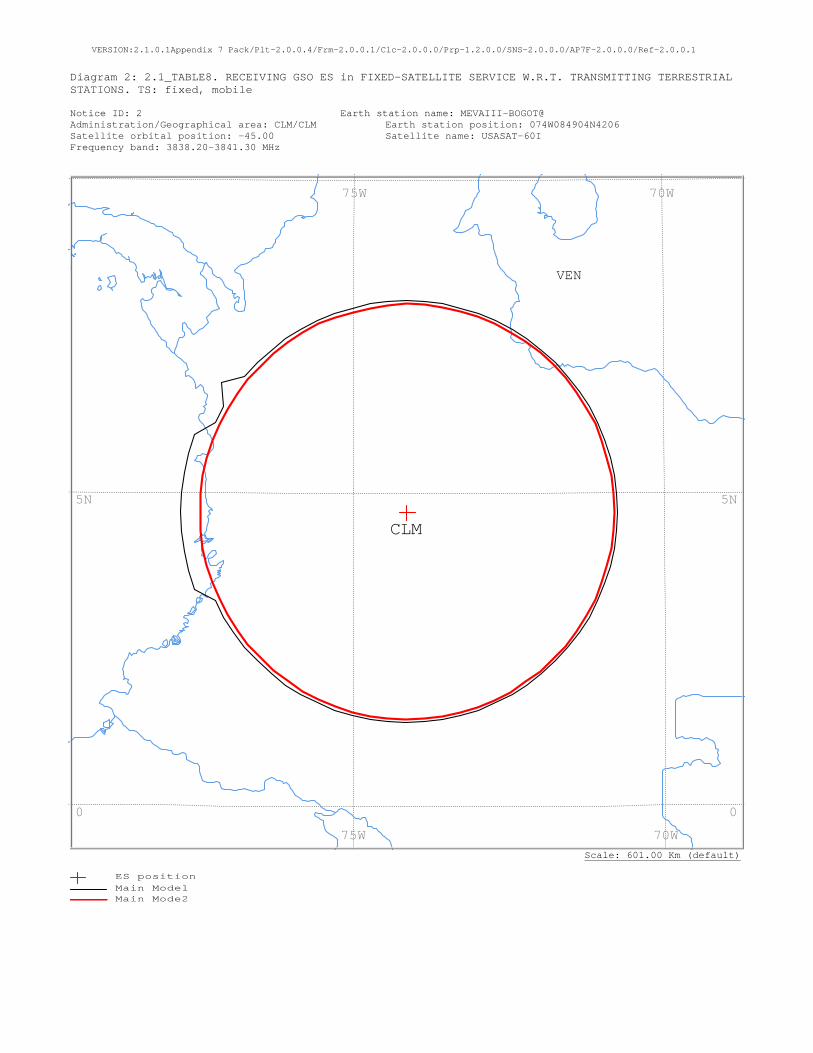
VERSION:2.1.0.1Appendix 7 Pack/Plt-2.0.0.4/Frm-2.0.0.1/Clc-2.0.0.0/Prp-1.2.0.0/SNS-2.0.0.0/AP7F-2.0.0.0/Ref-2.0.0.1
Diagram 2: 2.1_TABLE8. RECEIVING GSO ES in FIXED-SATELLITE SERVICE W.R.T. TRANSMITTING TERRESTRIAL STATIONS. TS: fixed, mobile Notice ID: 2 Earth station name: MEVAIII-BOGOT@ Administration/Geographical area: CLM/CLM Earth station position: 074W084904N4206 Satellite orbital position: -45.00 Satellite name: USASAT-60I Frequency band: 3838.20-3841.30 MHz
Scale: 601.00 Km (default)
VEN
CLM
70W 75W
70W 75W
5N
0
5N
0
ES positionMain Mode1 Main Mode2

Diagram 2: 2.1_TABLE8. RECEIVING GSO ES in FIXED-SATELLITE SERVICE W.R.T. TRANSMITTING TERRESTRIAL STATIONS. TS: fixed, mobile
NOTICE ID: 2 EARTH STATION NAME: MEVAIII-BOGOT@ EARTH STATION POSITION: 074W084904N4206 PHASE: D ADM/GEO_AREA: CLM/CLM RAIN CLIMATICAL ZONE: N SATELLITE NAME: USASAT-60I SATELLITE ORBITAL POSITION: -45.00 DEG ANTENNA AZIMUTH: 98.36 DEG ANTENNA ELEVATION: 55.62 DEG FREQUENCY BAND: 3838.20-3841.30 MHZ ASSIGNED FREQUENCY: 3839.75 MHZ PERCENTAGE OF TIME: 0.0017 % MAXIMUM ANTENNA GAIN: 42.1 DBI MAXIMUM POWER DENSITY: - DBW/HZ NOISE TEMPERATURE: 400.0 K ANTENNA PATTERN: APEREC015V01 2.1_TABLE8 Model: PLM_DUCTING TRANSMISSION LOSS MODE 1: 198.9 DB (DOES NOT INCLUDE HOR. CORR. AND ANT. GAIN) TRANSMISSION LOSS MODE 2: 156.9 DB AZIMUTH 0 5 10 15 20 25 30 35 40 45 50 55 60 65 70 75 80 85 90 95 100 105 110 115 OFF-AXIS 94.7 91.9 89.1 86.3 83.5 80.7 78.0 75.3 72.8 70.3 68.0 65.8 63.7 61.9 60.2 58.8 57.6 56.7 56.0 55.7 55.6 55.9 56.4 57.2 HOR.ELEV. - - - - - - - - - - - - - - - - - - - - - - - - HOR.CORR. - - - - - - - - - - - - - - - - - - - - - - - - ANT.GAIN -6.9 -6.9 -6.9 -6.9 -6.9 -6.9 -6.9 -6.9 -6.9 -6.9 -6.9 -6.9 -6.9 -6.9 -6.9 -6.9 -6.9 -6.9 -6.9 -6.9 -6.9 -6.9 -6.9 -6.9 COORDINATION DISTANCE (KM) MODE 1 0.0 DB 375 375 375 375 375 375 375 375 375 375 375 375 375 375 375 375 375 375 375 375 375 375 375 375 MODE 2 0.0 DEG 369 369 369 369 369 369 369 370 370 370 370 370 370 370 370 370 370 370 370 370 370 370 370 370 AZIMUTH 120 125 130 135 140 145 150 155 160 165 170 175 180 185 190 195 200 205 210 215 220 225 230 235 OFF-AXIS 58.3 59.7 61.3 63.1 65.0 67.2 69.5 71.9 74.4 77.1 79.8 82.5 85.3 88.1 90.9 93.7 96.5 99.3 102.0 104.7 107.2 109.7 112.0 114.2 HOR.ELEV. - - - - - - - - - - - - - - - - - - - - - - - - HOR.CORR. - - - - - - - - - - - - - - - - - - - - - - - - ANT.GAIN -6.9 -6.9 -6.9 -6.9 -6.9 -6.9 -6.9 -6.9 -6.9 -6.9 -6.9 -6.9 -6.9 -6.9 -6.9 -6.9 -6.9 -6.9 -6.9 -6.9 -6.9 -6.9 -6.9 -6.9 COORDINATION DISTANCE (KM) MODE 1 0.0 DB 375 375 375 375 375 375 375 375 375 375 375 375 375 375 375 375 375 375 375 375 375 375 375 375 MODE 2 0.0 DEG 370 370 370 370 370 370 370 370 370 369 369 369 369 369 369 369 368 368 368 368 368 368 368 368 AZIMUTH 240 245 250 255 260 265 270 275 280 285 290 295 300 305 310 315 320 325 330 335 340 345 350 355 OFF-AXIS 116.3 118.1 119.8 121.2 122.4 123.3 124.0 124.3 124.4 124.1 123.6 122.8 121.7 120.3 118.7 116.9 115.0 112.8 110.5 108.1 105.6 102.9 100.2 97.5 HOR.ELEV. - - - - - - - - - - - - - - - - - - - - - - - - HOR.CORR. - - - - - - - - - - - - - - - - - - - - - - - - ANT.GAIN -6.9 -6.9 -6.9 -6.9 -6.9 -6.9 -6.9 -6.9 -6.9 -6.9 -6.9 -6.9 -6.9 -6.9 -6.9 -6.9 -6.9 -6.9 -6.9 -6.9 -6.9 -6.9 -6.9 -6.9 COORDINATION DISTANCE (KM) MODE 1 0.0 DB 375 375 401 401 401 401 401 401 401 401 401 375 375 401 375 375 375 375 375 375 375 375 375 375 MODE 2 0.0 DEG 367 367 367 367 367 367 367 367 367 367 367 367 367 367 367 367 368 368 368 368 368 368 368 368 PROBABLY AFFECTED COUNTRIES: VEN
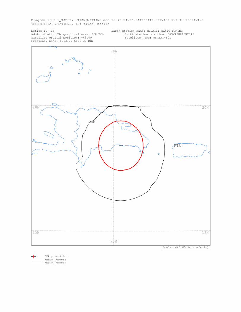
Diagram 1: 2.1_TABLE7. TRANSMITTING GSO ES in FIXED-SATELLITE SERVICE W.R.T. RECEIVING TERRESTRIAL STATIONS. TS: fixed, mobile Notice ID: 18 Earth station name: MEVAIII-SANTO DOMING Administration/Geographical area: DOM/DOM Earth station position: 069W400818N2546 Satellite orbital position: -45.00 Satellite name: USASAT-60I Frequency band: 6063.20-6066.30 MHz
Scale: 445.00 Km (default)
PTR
DOM
70W
70W
20N
15N
20N
15N
ES positionMain Mode1 Main Mode2
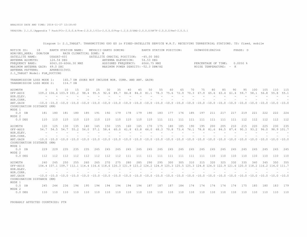
ANALYSIS DATE AND TIME: 2014-11-27 12:18:40
VERSION: 2.1.0.1Appendix 7 Pack/Plt-2.0.0.4/Frm-2.0.0.1/Clc-2.0.0.0/Prp-1.2.0.0/SNS-2.0.0.0/AP7F-2.0.0.0/Ref-2.0.0.1
Diagram 1: 2.1_TABLE7. TRANSMITTING GSO ES in FIXED-SATELLITE SERVICE W.R.T. RECEIVING TERRESTRIAL STATIONS. TS: fixed, mobile
NOTICE ID: 18 EARTH STATION NAME: MEVAIII-SANTO DOMING EARTH STATION POSITION: 069W400818N2546 PHASE: D ADM/GEO_AREA: DOM/DOM RAIN CLIMATICAL ZONE: N SATELLITE NAME: USASAT-60I SATELLITE ORBITAL POSITION: -45.00 DEG ANTENNA AZIMUTH: 124.54 DEG ANTENNA ELEVATION: 54.53 DEG FREQUENCY BAND: 6063.20-6066.30 MHZ ASSIGNED FREQUENCY: 6064.75 MHZ PERCENTAGE OF TIME: 0.0050 % MAXIMUM ANTENNA GAIN: 49.0 DBI MAXIMUM POWER DENSITY: -52.3 DBW/HZ NOISE TEMPERATURE: - K ANTENNA PATTERN: APEREC015V01 2.1_TABLE7 Model: PLM_DUCTING TRANSMISSION LOSS MODE 1: 160.7 DB (DOES NOT INCLUDE HOR. CORR. AND ANT. GAIN) TRANSMISSION LOSS MODE 2: 114.7 DB AZIMUTH 0 5 10 15 20 25 30 35 40 45 50 55 60 65 70 75 80 85 90 95 100 105 110 115 OFF-AXIS 109.2 106.6 103.9 101.2 98.4 95.5 92.6 89.7 86.8 84.0 81.1 78.3 75.6 72.9 70.3 67.9 65.6 63.4 61.4 59.7 58.1 56.8 55.8 55.1 HOR.ELEV. - - - - - - - - - - - - - - - - - - - - - - - - HOR.CORR. - - - - - - - - - - - - - - - - - - - - - - - - ANT.GAIN -10.0 -10.0 -10.0 -10.0 -10.0 -10.0 -10.0 -10.0 -10.0 -10.0 -10.0 -10.0 -10.0 -10.0 -10.0 -10.0 -10.0 -10.0 -10.0 -10.0 -10.0 -10.0 -10.0 -10.0 COORDINATION DISTANCE (KM) MODE 1 0.0 DB 181 180 181 180 185 191 192 179 178 179 190 183 177 176 185 197 211 217 217 219 221 222 222 224 MODE 2 0.0 DEG 110 110 110 110 110 110 110 110 110 110 110 111 111 111 111 111 111 111 111 112 112 112 112 112 AZIMUTH 120 125 130 135 140 145 150 155 160 165 170 175 180 185 190 195 200 205 210 215 220 225 230 235 OFF-AXIS 54.7 54.5 54.7 55.2 56.0 57.1 58.4 60.0 61.8 63.8 66.0 68.3 70.8 73.4 76.1 78.8 81.6 84.5 87.4 90.3 93.2 96.0 98.9 101.7 HOR.ELEV. - - - - - - - - - - - - - - - - - - - - - - - - HOR.CORR. - - - - - - - - - - - - - - - - - - - - - - - - ANT.GAIN -10.0 -10.0 -10.0 -10.0 -10.0 -10.0 -10.0 -10.0 -10.0 -10.0 -10.0 -10.0 -10.0 -10.0 -10.0 -10.0 -10.0 -10.0 -10.0 -10.0 -10.0 -10.0 -10.0 -10.0 COORDINATION DISTANCE (KM) MODE 1 0.0 DB 229 229 235 235 235 245 245 245 245 245 245 245 245 245 245 245 245 245 245 245 245 245 245 245 MODE 2 0.0 DEG 112 112 112 112 112 112 112 112 111 111 111 111 111 111 111 111 110 110 110 110 110 110 110 110 AZIMUTH 240 245 250 255 260 265 270 275 280 285 290 295 300 305 310 315 320 325 330 335 340 345 350 355 OFF-AXIS 104.4 107.1 109.7 112.1 114.4 116.6 118.6 120.3 121.9 123.2 124.2 124.9 125.3 125.5 125.3 124.8 124.0 122.9 121.6 120.0 118.2 116.2 114.0 111.7 HOR.ELEV. - - - - - - - - - - - - - - - - - - - - - - - - HOR.CORR. - - - - - - - - - - - - - - - - - - - - - - - - ANT.GAIN -10.0 -10.0 -10.0 -10.0 -10.0 -10.0 -10.0 -10.0 -10.0 -10.0 -10.0 -10.0 -10.0 -10.0 -10.0 -10.0 -10.0 -10.0 -10.0 -10.0 -10.0 -10.0 -10.0 -10.0 COORDINATION DISTANCE (KM) MODE 1 0.0 DB 245 244 236 196 195 194 194 194 194 194 187 187 187 184 174 174 174 174 174 175 185 180 183 179 MODE 2 0.0 DEG 110 110 110 110 110 110 110 110 110 110 110 110 110 110 110 110 110 110 110 110 110 110 110 110 PROBABLY AFFECTED COUNTRIES: PTR
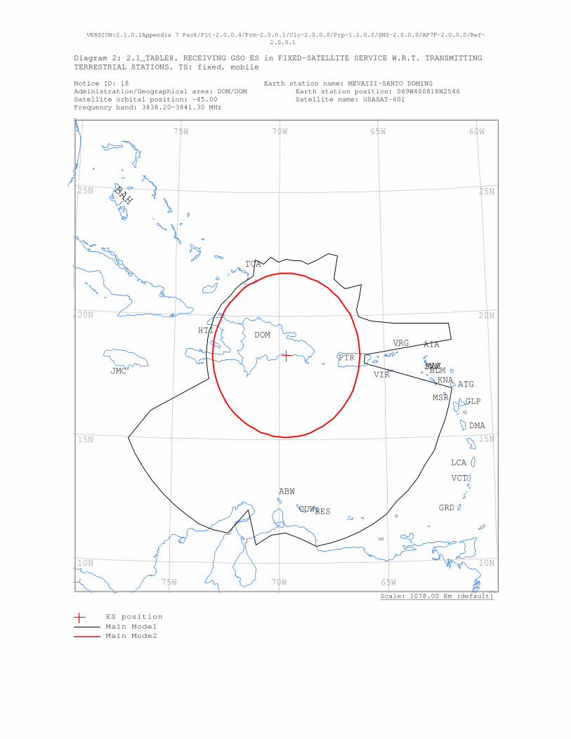
VERSION:2.1.0.1Appendix 7 Pack/Plt-2.0.0.4/Frm-2.0.0.1/Clc-2.0.0.0/Prp-1.2.0.0/SNS-2.0.0.0/AP7F-2.0.0.0/Ref-2.0.0.1
Diagram 2: 2.1_TABLE8. RECEIVING GSO ES in FIXED-SATELLITE SERVICE W.R.T. TRANSMITTING TERRESTRIAL STATIONS. TS: fixed, mobile Notice ID: 18 Earth station name: MEVAIII-SANTO DOMING Administration/Geographical area: DOM/DOM Earth station position: 069W400818N2546 Satellite orbital position: -45.00 Satellite name: USASAT-60I Frequency band: 3838.20-3841.30 MHz
Scale: 1078.00 Km (default)
VRG
VIR
VCT
TCA
SXMPTR
MSR
MAF
LCA
KNAJMC
HTI
GRD
GLP
DOM
DMA
CUW
BLM
BES
BAH
ATG
AIA
ABW
60W 65W 70W 75W
65W 70W 75W
25N
20N
15N
10N
25N
20N
15N
10N
ES positionMain Mode1 Main Mode2
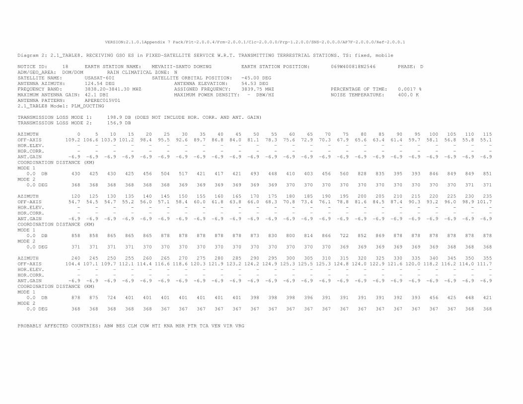
VERSION:2.1.0.1Appendix 7 Pack/Plt-2.0.0.4/Frm-2.0.0.1/Clc-2.0.0.0/Prp-1.2.0.0/SNS-2.0.0.0/AP7F-2.0.0.0/Ref-2.0.0.1
Diagram 2: 2.1_TABLE8. RECEIVING GSO ES in FIXED-SATELLITE SERVICE W.R.T. TRANSMITTING TERRESTRIAL STATIONS. TS: fixed, mobile
NOTICE ID: 18 EARTH STATION NAME: MEVAIII-SANTO DOMING EARTH STATION POSITION: 069W400818N2546 PHASE: D ADM/GEO_AREA: DOM/DOM RAIN CLIMATICAL ZONE: N SATELLITE NAME: USASAT-60I SATELLITE ORBITAL POSITION: -45.00 DEG ANTENNA AZIMUTH: 124.54 DEG ANTENNA ELEVATION: 54.53 DEG FREQUENCY BAND: 3838.20-3841.30 MHZ ASSIGNED FREQUENCY: 3839.75 MHZ PERCENTAGE OF TIME: 0.0017 % MAXIMUM ANTENNA GAIN: 42.1 DBI MAXIMUM POWER DENSITY: - DBW/HZ NOISE TEMPERATURE: 400.0 K ANTENNA PATTERN: APEREC015V01 2.1_TABLE8 Model: PLM_DUCTING TRANSMISSION LOSS MODE 1: 198.9 DB (DOES NOT INCLUDE HOR. CORR. AND ANT. GAIN) TRANSMISSION LOSS MODE 2: 156.9 DB AZIMUTH 0 5 10 15 20 25 30 35 40 45 50 55 60 65 70 75 80 85 90 95 100 105 110 115 OFF-AXIS 109.2 106.6 103.9 101.2 98.4 95.5 92.6 89.7 86.8 84.0 81.1 78.3 75.6 72.9 70.3 67.9 65.6 63.4 61.4 59.7 58.1 56.8 55.8 55.1 HOR.ELEV. - - - - - - - - - - - - - - - - - - - - - - - - HOR.CORR. - - - - - - - - - - - - - - - - - - - - - - - - ANT.GAIN -6.9 -6.9 -6.9 -6.9 -6.9 -6.9 -6.9 -6.9 -6.9 -6.9 -6.9 -6.9 -6.9 -6.9 -6.9 -6.9 -6.9 -6.9 -6.9 -6.9 -6.9 -6.9 -6.9 -6.9 COORDINATION DISTANCE (KM) MODE 1 0.0 DB 430 425 430 425 456 504 517 421 417 421 493 448 410 403 456 560 828 835 395 393 846 849 849 851 MODE 2 0.0 DEG 368 368 368 368 368 368 369 369 369 369 369 369 370 370 370 370 370 370 370 370 370 370 371 371 AZIMUTH 120 125 130 135 140 145 150 155 160 165 170 175 180 185 190 195 200 205 210 215 220 225 230 235 OFF-AXIS 54.7 54.5 54.7 55.2 56.0 57.1 58.4 60.0 61.8 63.8 66.0 68.3 70.8 73.4 76.1 78.8 81.6 84.5 87.4 90.3 93.2 96.0 98.9 101.7 HOR.ELEV. - - - - - - - - - - - - - - - - - - - - - - - - HOR.CORR. - - - - - - - - - - - - - - - - - - - - - - - - ANT.GAIN -6.9 -6.9 -6.9 -6.9 -6.9 -6.9 -6.9 -6.9 -6.9 -6.9 -6.9 -6.9 -6.9 -6.9 -6.9 -6.9 -6.9 -6.9 -6.9 -6.9 -6.9 -6.9 -6.9 -6.9 COORDINATION DISTANCE (KM) MODE 1 0.0 DB 858 858 865 865 865 878 878 878 878 878 873 830 800 814 866 722 852 869 878 878 878 878 878 878 MODE 2 0.0 DEG 371 371 371 371 370 370 370 370 370 370 370 370 370 370 370 369 369 369 369 369 369 368 368 368 AZIMUTH 240 245 250 255 260 265 270 275 280 285 290 295 300 305 310 315 320 325 330 335 340 345 350 355 OFF-AXIS 104.4 107.1 109.7 112.1 114.4 116.6 118.6 120.3 121.9 123.2 124.2 124.9 125.3 125.5 125.3 124.8 124.0 122.9 121.6 120.0 118.2 116.2 114.0 111.7 HOR.ELEV. - - - - - - - - - - - - - - - - - - - - - - - - HOR.CORR. - - - - - - - - - - - - - - - - - - - - - - - - ANT.GAIN -6.9 -6.9 -6.9 -6.9 -6.9 -6.9 -6.9 -6.9 -6.9 -6.9 -6.9 -6.9 -6.9 -6.9 -6.9 -6.9 -6.9 -6.9 -6.9 -6.9 -6.9 -6.9 -6.9 -6.9 COORDINATION DISTANCE (KM) MODE 1 0.0 DB 878 875 724 401 401 401 401 401 401 401 398 398 398 396 391 391 391 391 392 393 456 425 448 421 MODE 2 0.0 DEG 368 368 368 368 368 367 367 367 367 367 367 367 367 367 367 367 367 367 367 367 367 367 368 368 PROBABLY AFFECTED COUNTRIES: ABW BES CLM CUW HTI KNA MSR PTR TCA VEN VIR VRG
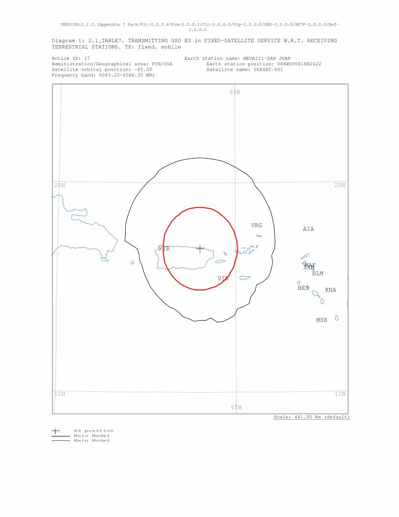
VERSION:2.1.0.1Appendix 7 Pack/Plt-2.0.0.4/Frm-2.0.0.1/Clc-2.0.0.0/Prp-1.2.0.0/SNS-2.0.0.0/AP7F-2.0.0.0/Ref-2.0.0.1
Diagram 1: 2.1_TABLE7. TRANSMITTING GSO ES in FIXED-SATELLITE SERVICE W.R.T. RECEIVING TERRESTRIAL STATIONS. TS: fixed, mobile Notice ID: 17 Earth station name: MEVAIII-SAN JUAN Administration/Geographical area: PTR/USA Earth station position: 066W000618N2622 Satellite orbital position: -45.00 Satellite name: USASAT-60I Frequency band: 6063.20-6066.30 MHz
Scale: 441.00 Km (default)
VRG
VIR
SXM
PTR
MSR
MAF
KNA
BLM
BES
AIA
65W
65W
20N
15N
20N
15N
ES positionMain Mode1 Main Mode2
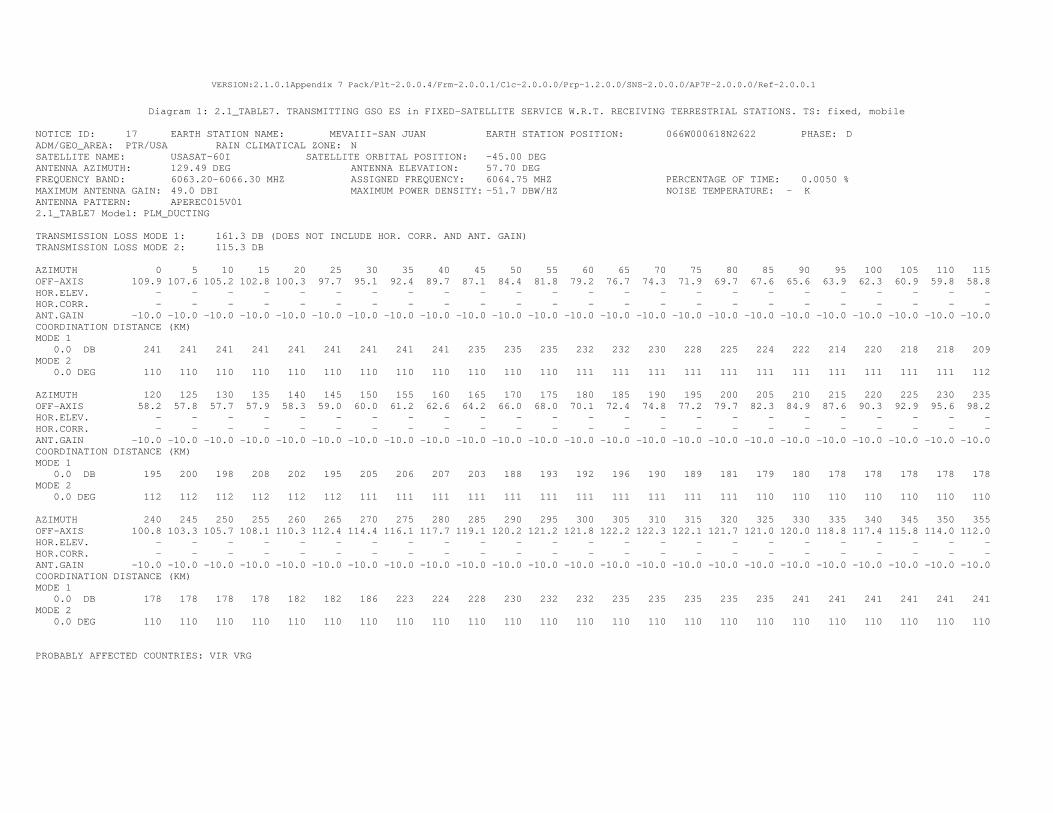
VERSION:2.1.0.1Appendix 7 Pack/Plt-2.0.0.4/Frm-2.0.0.1/Clc-2.0.0.0/Prp-1.2.0.0/SNS-2.0.0.0/AP7F-2.0.0.0/Ref-2.0.0.1
Diagram 1: 2.1_TABLE7. TRANSMITTING GSO ES in FIXED-SATELLITE SERVICE W.R.T. RECEIVING TERRESTRIAL STATIONS. TS: fixed, mobile
NOTICE ID: 17 EARTH STATION NAME: MEVAIII-SAN JUAN EARTH STATION POSITION: 066W000618N2622 PHASE: D ADM/GEO_AREA: PTR/USA RAIN CLIMATICAL ZONE: N SATELLITE NAME: USASAT-60I SATELLITE ORBITAL POSITION: -45.00 DEG ANTENNA AZIMUTH: 129.49 DEG ANTENNA ELEVATION: 57.70 DEG FREQUENCY BAND: 6063.20-6066.30 MHZ ASSIGNED FREQUENCY: 6064.75 MHZ PERCENTAGE OF TIME: 0.0050 % MAXIMUM ANTENNA GAIN: 49.0 DBI MAXIMUM POWER DENSITY: -51.7 DBW/HZ NOISE TEMPERATURE: - K ANTENNA PATTERN: APEREC015V01 2.1_TABLE7 Model: PLM_DUCTING TRANSMISSION LOSS MODE 1: 161.3 DB (DOES NOT INCLUDE HOR. CORR. AND ANT. GAIN) TRANSMISSION LOSS MODE 2: 115.3 DB AZIMUTH 0 5 10 15 20 25 30 35 40 45 50 55 60 65 70 75 80 85 90 95 100 105 110 115 OFF-AXIS 109.9 107.6 105.2 102.8 100.3 97.7 95.1 92.4 89.7 87.1 84.4 81.8 79.2 76.7 74.3 71.9 69.7 67.6 65.6 63.9 62.3 60.9 59.8 58.8 HOR.ELEV. - - - - - - - - - - - - - - - - - - - - - - - - HOR.CORR. - - - - - - - - - - - - - - - - - - - - - - - - ANT.GAIN -10.0 -10.0 -10.0 -10.0 -10.0 -10.0 -10.0 -10.0 -10.0 -10.0 -10.0 -10.0 -10.0 -10.0 -10.0 -10.0 -10.0 -10.0 -10.0 -10.0 -10.0 -10.0 -10.0 -10.0 COORDINATION DISTANCE (KM) MODE 1 0.0 DB 241 241 241 241 241 241 241 241 241 235 235 235 232 232 230 228 225 224 222 214 220 218 218 209 MODE 2 0.0 DEG 110 110 110 110 110 110 110 110 110 110 110 110 111 111 111 111 111 111 111 111 111 111 111 112 AZIMUTH 120 125 130 135 140 145 150 155 160 165 170 175 180 185 190 195 200 205 210 215 220 225 230 235 OFF-AXIS 58.2 57.8 57.7 57.9 58.3 59.0 60.0 61.2 62.6 64.2 66.0 68.0 70.1 72.4 74.8 77.2 79.7 82.3 84.9 87.6 90.3 92.9 95.6 98.2 HOR.ELEV. - - - - - - - - - - - - - - - - - - - - - - - - HOR.CORR. - - - - - - - - - - - - - - - - - - - - - - - - ANT.GAIN -10.0 -10.0 -10.0 -10.0 -10.0 -10.0 -10.0 -10.0 -10.0 -10.0 -10.0 -10.0 -10.0 -10.0 -10.0 -10.0 -10.0 -10.0 -10.0 -10.0 -10.0 -10.0 -10.0 -10.0 COORDINATION DISTANCE (KM) MODE 1 0.0 DB 195 200 198 208 202 195 205 206 207 203 188 193 192 196 190 189 181 179 180 178 178 178 178 178 MODE 2 0.0 DEG 112 112 112 112 112 112 111 111 111 111 111 111 111 111 111 111 111 110 110 110 110 110 110 110 AZIMUTH 240 245 250 255 260 265 270 275 280 285 290 295 300 305 310 315 320 325 330 335 340 345 350 355 OFF-AXIS 100.8 103.3 105.7 108.1 110.3 112.4 114.4 116.1 117.7 119.1 120.2 121.2 121.8 122.2 122.3 122.1 121.7 121.0 120.0 118.8 117.4 115.8 114.0 112.0 HOR.ELEV. - - - - - - - - - - - - - - - - - - - - - - - - HOR.CORR. - - - - - - - - - - - - - - - - - - - - - - - - ANT.GAIN -10.0 -10.0 -10.0 -10.0 -10.0 -10.0 -10.0 -10.0 -10.0 -10.0 -10.0 -10.0 -10.0 -10.0 -10.0 -10.0 -10.0 -10.0 -10.0 -10.0 -10.0 -10.0 -10.0 -10.0 COORDINATION DISTANCE (KM) MODE 1 0.0 DB 178 178 178 178 182 182 186 223 224 228 230 232 232 235 235 235 235 235 241 241 241 241 241 241 MODE 2 0.0 DEG 110 110 110 110 110 110 110 110 110 110 110 110 110 110 110 110 110 110 110 110 110 110 110 110 PROBABLY AFFECTED COUNTRIES: VIR VRG
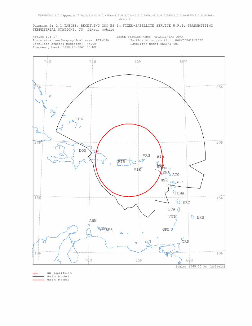
VERSION:2.1.0.1Appendix 7 Pack/Plt-2.0.0.4/Frm-2.0.0.1/Clc-2.0.0.0/Prp-1.2.0.0/SNS-2.0.0.0/AP7F-2.0.0.0/Ref-2.0.0.1
Diagram 2: 2.1_TABLE8. RECEIVING GSO ES in FIXED-SATELLITE SERVICE W.R.T. TRANSMITTING TERRESTRIAL STATIONS. TS: fixed, mobile Notice ID: 17 Earth station name: MEVAIII-SAN JUAN Administration/Geographical area: PTR/USA Earth station position: 066W000618N2622 Satellite orbital position: -45.00 Satellite name: USASAT-60I Frequency band: 3838.20-3841.30 MHz
Scale: 1065.00 Km (default)
VRG
VIR
VCT
TRD
TCA
SXMPTR
MSR
MRT
MAF
LCA
KNA
HTI
GRD
GLP
DOM
DMA
CUW
BRB
BLM
BES
ATG
AIA
ABW
60W 65W 70W 75W
60W 65W 70W
25N
20N
15N
10N
25N
20N
15N
10N
ES positionMain Mode1 Main Mode2
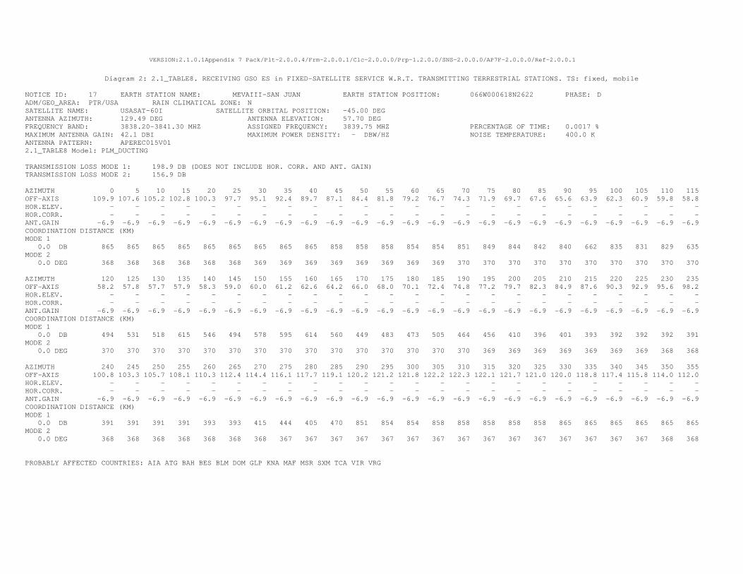
VERSION:2.1.0.1Appendix 7 Pack/Plt-2.0.0.4/Frm-2.0.0.1/Clc-2.0.0.0/Prp-1.2.0.0/SNS-2.0.0.0/AP7F-2.0.0.0/Ref-2.0.0.1
Diagram 2: 2.1_TABLE8. RECEIVING GSO ES in FIXED-SATELLITE SERVICE W.R.T. TRANSMITTING TERRESTRIAL STATIONS. TS: fixed, mobile
NOTICE ID: 17 EARTH STATION NAME: MEVAIII-SAN JUAN EARTH STATION POSITION: 066W000618N2622 PHASE: D ADM/GEO_AREA: PTR/USA RAIN CLIMATICAL ZONE: N SATELLITE NAME: USASAT-60I SATELLITE ORBITAL POSITION: -45.00 DEG ANTENNA AZIMUTH: 129.49 DEG ANTENNA ELEVATION: 57.70 DEG FREQUENCY BAND: 3838.20-3841.30 MHZ ASSIGNED FREQUENCY: 3839.75 MHZ PERCENTAGE OF TIME: 0.0017 % MAXIMUM ANTENNA GAIN: 42.1 DBI MAXIMUM POWER DENSITY: - DBW/HZ NOISE TEMPERATURE: 400.0 K ANTENNA PATTERN: APEREC015V01 2.1_TABLE8 Model: PLM_DUCTING TRANSMISSION LOSS MODE 1: 198.9 DB (DOES NOT INCLUDE HOR. CORR. AND ANT. GAIN) TRANSMISSION LOSS MODE 2: 156.9 DB AZIMUTH 0 5 10 15 20 25 30 35 40 45 50 55 60 65 70 75 80 85 90 95 100 105 110 115 OFF-AXIS 109.9 107.6 105.2 102.8 100.3 97.7 95.1 92.4 89.7 87.1 84.4 81.8 79.2 76.7 74.3 71.9 69.7 67.6 65.6 63.9 62.3 60.9 59.8 58.8 HOR.ELEV. - - - - - - - - - - - - - - - - - - - - - - - - HOR.CORR. - - - - - - - - - - - - - - - - - - - - - - - - ANT.GAIN -6.9 -6.9 -6.9 -6.9 -6.9 -6.9 -6.9 -6.9 -6.9 -6.9 -6.9 -6.9 -6.9 -6.9 -6.9 -6.9 -6.9 -6.9 -6.9 -6.9 -6.9 -6.9 -6.9 -6.9 COORDINATION DISTANCE (KM) MODE 1 0.0 DB 865 865 865 865 865 865 865 865 865 858 858 858 854 854 851 849 844 842 840 662 835 831 829 635 MODE 2 0.0 DEG 368 368 368 368 368 368 369 369 369 369 369 369 369 369 370 370 370 370 370 370 370 370 370 370 AZIMUTH 120 125 130 135 140 145 150 155 160 165 170 175 180 185 190 195 200 205 210 215 220 225 230 235 OFF-AXIS 58.2 57.8 57.7 57.9 58.3 59.0 60.0 61.2 62.6 64.2 66.0 68.0 70.1 72.4 74.8 77.2 79.7 82.3 84.9 87.6 90.3 92.9 95.6 98.2 HOR.ELEV. - - - - - - - - - - - - - - - - - - - - - - - - HOR.CORR. - - - - - - - - - - - - - - - - - - - - - - - - ANT.GAIN -6.9 -6.9 -6.9 -6.9 -6.9 -6.9 -6.9 -6.9 -6.9 -6.9 -6.9 -6.9 -6.9 -6.9 -6.9 -6.9 -6.9 -6.9 -6.9 -6.9 -6.9 -6.9 -6.9 -6.9 COORDINATION DISTANCE (KM) MODE 1 0.0 DB 494 531 518 615 546 494 578 595 614 560 449 483 473 505 464 456 410 396 401 393 392 392 392 391 MODE 2 0.0 DEG 370 370 370 370 370 370 370 370 370 370 370 370 370 370 370 369 369 369 369 369 369 369 368 368 AZIMUTH 240 245 250 255 260 265 270 275 280 285 290 295 300 305 310 315 320 325 330 335 340 345 350 355 OFF-AXIS 100.8 103.3 105.7 108.1 110.3 112.4 114.4 116.1 117.7 119.1 120.2 121.2 121.8 122.2 122.3 122.1 121.7 121.0 120.0 118.8 117.4 115.8 114.0 112.0 HOR.ELEV. - - - - - - - - - - - - - - - - - - - - - - - - HOR.CORR. - - - - - - - - - - - - - - - - - - - - - - - - ANT.GAIN -6.9 -6.9 -6.9 -6.9 -6.9 -6.9 -6.9 -6.9 -6.9 -6.9 -6.9 -6.9 -6.9 -6.9 -6.9 -6.9 -6.9 -6.9 -6.9 -6.9 -6.9 -6.9 -6.9 -6.9 COORDINATION DISTANCE (KM) MODE 1 0.0 DB 391 391 391 391 393 393 415 444 405 470 851 854 854 858 858 858 858 858 865 865 865 865 865 865 MODE 2 0.0 DEG 368 368 368 368 368 368 368 367 367 367 367 367 367 367 367 367 367 367 367 367 367 367 368 368 PROBABLY AFFECTED COUNTRIES: AIA ATG BAH BES BLM DOM GLP KNA MAF MSR SXM TCA VIR VRG
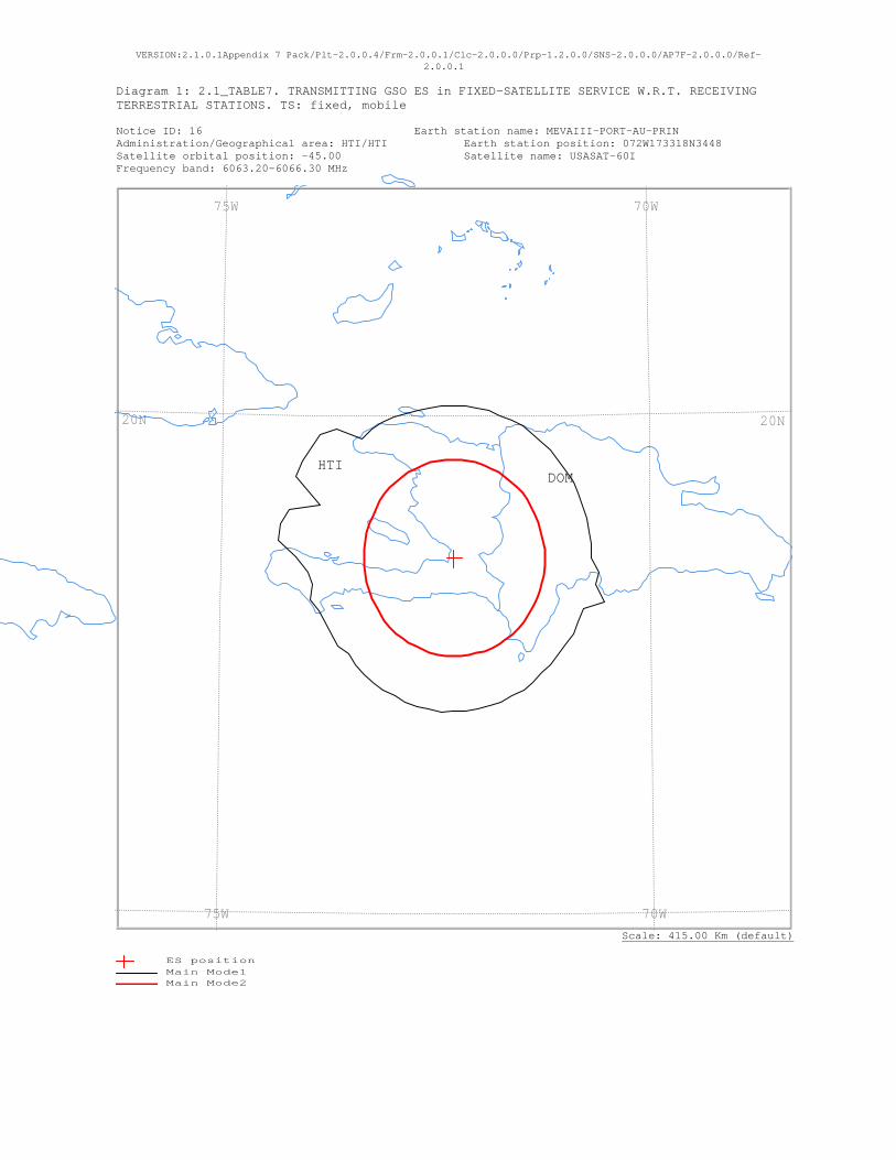
VERSION:2.1.0.1Appendix 7 Pack/Plt-2.0.0.4/Frm-2.0.0.1/Clc-2.0.0.0/Prp-1.2.0.0/SNS-2.0.0.0/AP7F-2.0.0.0/Ref-2.0.0.1
Diagram 1: 2.1_TABLE7. TRANSMITTING GSO ES in FIXED-SATELLITE SERVICE W.R.T. RECEIVING TERRESTRIAL STATIONS. TS: fixed, mobile Notice ID: 16 Earth station name: MEVAIII-PORT-AU-PRIN Administration/Geographical area: HTI/HTI Earth station position: 072W173318N3448 Satellite orbital position: -45.00 Satellite name: USASAT-60I Frequency band: 6063.20-6066.30 MHz
Scale: 415.00 Km (default)
HTIDOM
70W 75W
70W 75W
20N20N
ES positionMain Mode1 Main Mode2

VERSION:2.1.0.1Appendix 7 Pack/Plt-2.0.0.4/Frm-2.0.0.1/Clc-2.0.0.0/Prp-1.2.0.0/SNS-2.0.0.0/AP7F-2.0.0.0/Ref-2.0.0.1
Diagram 1: 2.1_TABLE7. TRANSMITTING GSO ES in FIXED-SATELLITE SERVICE W.R.T. RECEIVING TERRESTRIAL STATIONS. TS: fixed, mobile
NOTICE ID: 16 EARTH STATION NAME: MEVAIII-PORT-AU-PRIN EARTH STATION POSITION: 072W173318N3448 PHASE: D ADM/GEO_AREA: HTI/HTI RAIN CLIMATICAL ZONE: N SATELLITE NAME: USASAT-60I SATELLITE ORBITAL POSITION: -45.00 DEG ANTENNA AZIMUTH: 121.70 DEG ANTENNA ELEVATION: 52.06 DEG FREQUENCY BAND: 6063.20-6066.30 MHZ ASSIGNED FREQUENCY: 6064.75 MHZ PERCENTAGE OF TIME: 0.0050 % MAXIMUM ANTENNA GAIN: 49.0 DBI MAXIMUM POWER DENSITY: -53.0 DBW/HZ NOISE TEMPERATURE: - K ANTENNA PATTERN: APEREC015V01 2.1_TABLE7 Model: PLM_DUCTING TRANSMISSION LOSS MODE 1: 160.0 DB (DOES NOT INCLUDE HOR. CORR. AND ANT. GAIN) TRANSMISSION LOSS MODE 2: 114.0 DB AZIMUTH 0 5 10 15 20 25 30 35 40 45 50 55 60 65 70 75 80 85 90 95 100 105 110 115 OFF-AXIS 108.8 106.0 103.1 100.2 97.2 94.1 91.0 88.0 84.9 81.9 78.9 75.9 73.1 70.3 67.6 65.1 62.7 60.5 58.5 56.7 55.2 53.9 53.0 52.4 HOR.ELEV. - - - - - - - - - - - - - - - - - - - - - - - - HOR.CORR. - - - - - - - - - - - - - - - - - - - - - - - - ANT.GAIN -10.0 -10.0 -10.0 -10.0 -10.0 -10.0 -10.0 -10.0 -10.0 -10.0 -10.0 -10.0 -10.0 -10.0 -10.0 -10.0 -10.0 -10.0 -10.0 -10.0 -10.0 -10.0 -10.0 -10.0 COORDINATION DISTANCE (KM) MODE 1 0.0 DB 169 169 169 169 169 169 169 169 169 169 169 169 169 169 169 169 169 169 169 179 177 192 170 169 MODE 2 0.0 DEG 110 110 110 110 110 110 110 110 110 110 111 111 111 111 111 111 111 112 112 112 112 112 112 112 AZIMUTH 120 125 130 135 140 145 150 155 160 165 170 175 180 185 190 195 200 205 210 215 220 225 230 235 OFF-AXIS 52.1 52.1 52.5 53.3 54.3 55.6 57.2 59.1 61.2 63.4 65.9 68.4 71.2 74.0 76.9 79.8 82.8 85.9 89.0 92.0 95.1 98.1 101.1 104.1 HOR.ELEV. - - - - - - - - - - - - - - - - - - - - - - - - HOR.CORR. - - - - - - - - - - - - - - - - - - - - - - - - ANT.GAIN -10.0 -10.0 -10.0 -10.0 -10.0 -10.0 -10.0 -10.0 -10.0 -10.0 -10.0 -10.0 -10.0 -10.0 -10.0 -10.0 -10.0 -10.0 -10.0 -10.0 -10.0 -10.0 -10.0 -10.0 COORDINATION DISTANCE (KM) MODE 1 0.0 DB 169 169 169 169 169 170 171 171 171 171 172 172 172 173 172 172 172 171 171 171 171 169 169 173 MODE 2 0.0 DEG 112 112 112 112 112 112 112 112 112 111 111 111 111 111 111 111 110 110 110 110 110 110 110 110 AZIMUTH 240 245 250 255 260 265 270 275 280 285 290 295 300 305 310 315 320 325 330 335 340 345 350 355 OFF-AXIS 106.9 109.7 112.4 114.9 117.3 119.5 121.5 123.3 124.8 126.1 127.0 127.6 127.9 127.9 127.5 126.7 125.7 124.4 122.8 120.9 118.8 116.6 114.1 111.6 HOR.ELEV. - - - - - - - - - - - - - - - - - - - - - - - - HOR.CORR. - - - - - - - - - - - - - - - - - - - - - - - - ANT.GAIN -10.0 -10.0 -10.0 -10.0 -10.0 -10.0 -10.0 -10.0 -10.0 -10.0 -10.0 -10.0 -10.0 -10.0 -10.0 -10.0 -10.0 -10.0 -10.0 -10.0 -10.0 -10.0 -10.0 -10.0 COORDINATION DISTANCE (KM) MODE 1 0.0 DB 173 174 175 181 175 179 194 215 215 209 174 214 215 213 213 202 174 174 174 173 170 169 169 169 MODE 2 0.0 DEG 110 110 110 110 110 110 110 110 110 110 110 110 110 110 110 110 110 110 110 110 110 110 110 110 PROBABLY AFFECTED COUNTRIES: DOM
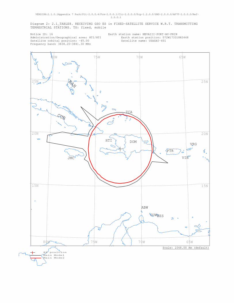
VERSION:2.1.0.1Appendix 7 Pack/Plt-2.0.0.4/Frm-2.0.0.1/Clc-2.0.0.0/Prp-1.2.0.0/SNS-2.0.0.0/AP7F-2.0.0.0/Ref-2.0.0.1
Diagram 2: 2.1_TABLE8. RECEIVING GSO ES in FIXED-SATELLITE SERVICE W.R.T. TRANSMITTING TERRESTRIAL STATIONS. TS: fixed, mobile Notice ID: 16 Earth station name: MEVAIII-PORT-AU-PRIN Administration/Geographical area: HTI/HTI Earth station position: 072W173318N3448 Satellite orbital position: -45.00 Satellite name: USASAT-60I Frequency band: 3838.20-3841.30 MHz
Scale: 1048.00 Km (default)
VRG
VIR
TCA
PTR
JMC
HTI DOM
CUW
CUB
BES
BAH
ABW
65W 70W 75W 80W
65W 70W 75W 80W
25N
20N
15N
25N
20N
15N
ES positionMain Mode1 Main Mode2
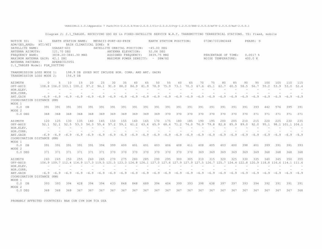
VERSION:2.1.0.1Appendix 7 Pack/Plt-2.0.0.4/Frm-2.0.0.1/Clc-2.0.0.0/Prp-1.2.0.0/SNS-2.0.0.0/AP7F-2.0.0.0/Ref-2.0.0.1
Diagram 2: 2.1_TABLE8. RECEIVING GSO ES in FIXED-SATELLITE SERVICE W.R.T. TRANSMITTING TERRESTRIAL STATIONS. TS: fixed, mobile
NOTICE ID: 16 EARTH STATION NAME: MEVAIII-PORT-AU-PRIN EARTH STATION POSITION: 072W173318N3448 PHASE: D ADM/GEO_AREA: HTI/HTI RAIN CLIMATICAL ZONE: N SATELLITE NAME: USASAT-60I SATELLITE ORBITAL POSITION: -45.00 DEG ANTENNA AZIMUTH: 121.70 DEG ANTENNA ELEVATION: 52.06 DEG FREQUENCY BAND: 3838.20-3841.30 MHZ ASSIGNED FREQUENCY: 3839.75 MHZ PERCENTAGE OF TIME: 0.0017 % MAXIMUM ANTENNA GAIN: 42.1 DBI MAXIMUM POWER DENSITY: - DBW/HZ NOISE TEMPERATURE: 400.0 K ANTENNA PATTERN: APEREC015V01 2.1_TABLE8 Model: PLM_DUCTING TRANSMISSION LOSS MODE 1: 198.9 DB (DOES NOT INCLUDE HOR. CORR. AND ANT. GAIN) TRANSMISSION LOSS MODE 2: 156.9 DB AZIMUTH 0 5 10 15 20 25 30 35 40 45 50 55 60 65 70 75 80 85 90 95 100 105 110 115 OFF-AXIS 108.8 106.0 103.1 100.2 97.2 94.1 91.0 88.0 84.9 81.9 78.9 75.9 73.1 70.3 67.6 65.1 62.7 60.5 58.5 56.7 55.2 53.9 53.0 52.4 HOR.ELEV. - - - - - - - - - - - - - - - - - - - - - - - - HOR.CORR. - - - - - - - - - - - - - - - - - - - - - - - - ANT.GAIN -6.9 -6.9 -6.9 -6.9 -6.9 -6.9 -6.9 -6.9 -6.9 -6.9 -6.9 -6.9 -6.9 -6.9 -6.9 -6.9 -6.9 -6.9 -6.9 -6.9 -6.9 -6.9 -6.9 -6.9 COORDINATION DISTANCE (KM) MODE 1 0.0 DB 391 391 391 391 391 391 391 391 391 391 391 391 391 391 391 391 391 391 391 393 442 576 395 391 MODE 2 0.0 DEG 368 368 368 368 368 369 369 369 369 369 369 370 370 370 370 370 370 370 370 371 371 371 371 371 AZIMUTH 120 125 130 135 140 145 150 155 160 165 170 175 180 185 190 195 200 205 210 215 220 225 230 235 OFF-AXIS 52.1 52.1 52.5 53.3 54.3 55.6 57.2 59.1 61.2 63.4 65.9 68.4 71.2 74.0 76.9 79.8 82.8 85.9 89.0 92.0 95.1 98.1 101.1 104.1 HOR.ELEV. - - - - - - - - - - - - - - - - - - - - - - - - HOR.CORR. - - - - - - - - - - - - - - - - - - - - - - - - ANT.GAIN -6.9 -6.9 -6.9 -6.9 -6.9 -6.9 -6.9 -6.9 -6.9 -6.9 -6.9 -6.9 -6.9 -6.9 -6.9 -6.9 -6.9 -6.9 -6.9 -6.9 -6.9 -6.9 -6.9 -6.9 COORDINATION DISTANCE (KM) MODE 1 0.0 DB 391 391 391 391 391 394 399 400 401 401 403 406 408 411 408 405 403 400 398 401 399 391 391 393 MODE 2 0.0 DEG 371 371 371 371 371 371 370 370 370 370 370 370 370 370 369 369 369 369 369 369 368 368 368 368 AZIMUTH 240 245 250 255 260 265 270 275 280 285 290 295 300 305 310 315 320 325 330 335 340 345 350 355 OFF-AXIS 106.9 109.7 112.4 114.9 117.3 119.5 121.5 123.3 124.8 126.1 127.0 127.6 127.9 127.9 127.5 126.7 125.7 124.4 122.8 120.9 118.8 116.6 114.1 111.6 HOR.ELEV. - - - - - - - - - - - - - - - - - - - - - - - - HOR.CORR. - - - - - - - - - - - - - - - - - - - - - - - - ANT.GAIN -6.9 -6.9 -6.9 -6.9 -6.9 -6.9 -6.9 -6.9 -6.9 -6.9 -6.9 -6.9 -6.9 -6.9 -6.9 -6.9 -6.9 -6.9 -6.9 -6.9 -6.9 -6.9 -6.9 -6.9 COORDINATION DISTANCE (KM) MODE 1 0.0 DB 393 393 394 428 394 394 433 848 848 689 394 404 399 393 398 638 397 397 393 394 392 391 391 391 MODE 2 0.0 DEG 368 368 368 367 367 367 367 367 367 367 367 367 367 367 367 367 367 367 367 367 367 367 367 368 PROBABLY AFFECTED COUNTRIES: BAH CUB CYM DOM TCA USA
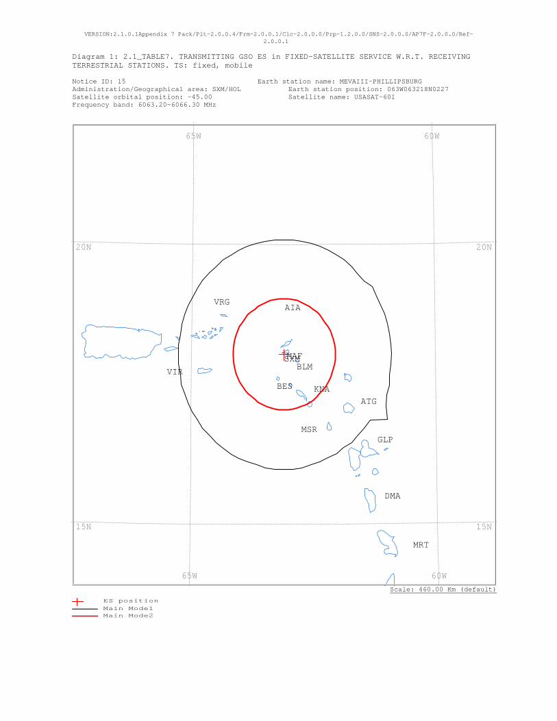
VERSION:2.1.0.1Appendix 7 Pack/Plt-2.0.0.4/Frm-2.0.0.1/Clc-2.0.0.0/Prp-1.2.0.0/SNS-2.0.0.0/AP7F-2.0.0.0/Ref-2.0.0.1
Diagram 1: 2.1_TABLE7. TRANSMITTING GSO ES in FIXED-SATELLITE SERVICE W.R.T. RECEIVING TERRESTRIAL STATIONS. TS: fixed, mobile Notice ID: 15 Earth station name: MEVAIII-PHILLIPSBURG Administration/Geographical area: SXM/HOL Earth station position: 063W063218N0227 Satellite orbital position: -45.00 Satellite name: USASAT-60I Frequency band: 6063.20-6066.30 MHz
Scale: 460.00 Km (default)
VRG
VIRSXM
MSR
MRT
MAF
KNA
GLP
DMA
BLM
BES
ATG
AIA
60W 65W
60W 65W
20N
15N
20N
15N
ES positionMain Mode1 Main Mode2
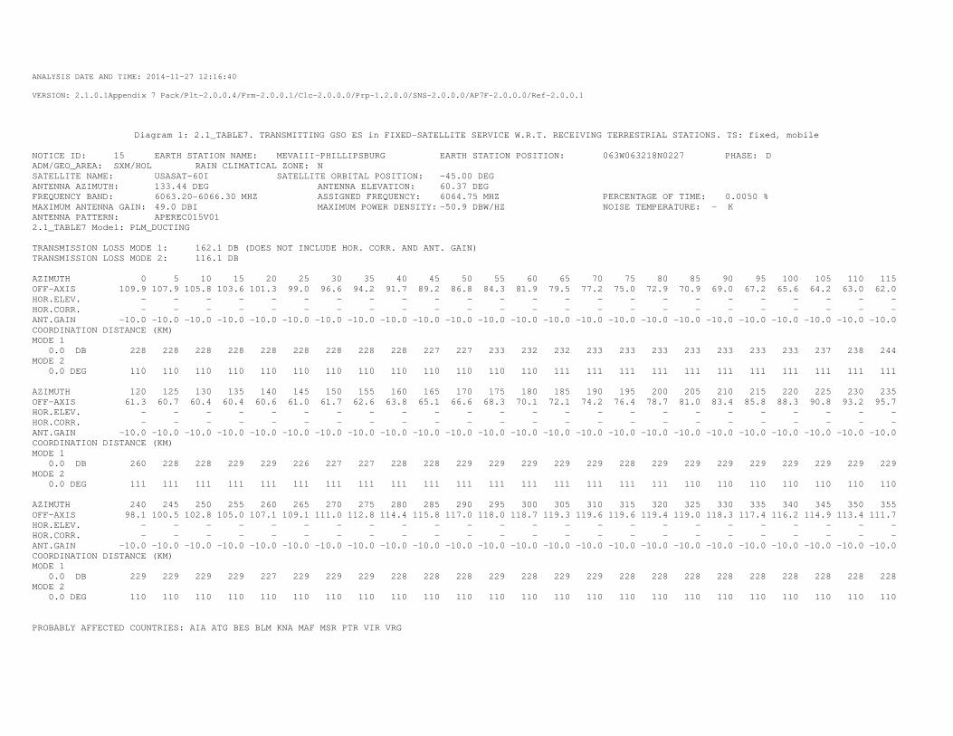
ANALYSIS DATE AND TIME: 2014-11-27 12:16:40
VERSION: 2.1.0.1Appendix 7 Pack/Plt-2.0.0.4/Frm-2.0.0.1/Clc-2.0.0.0/Prp-1.2.0.0/SNS-2.0.0.0/AP7F-2.0.0.0/Ref-2.0.0.1
Diagram 1: 2.1_TABLE7. TRANSMITTING GSO ES in FIXED-SATELLITE SERVICE W.R.T. RECEIVING TERRESTRIAL STATIONS. TS: fixed, mobile
NOTICE ID: 15 EARTH STATION NAME: MEVAIII-PHILLIPSBURG EARTH STATION POSITION: 063W063218N0227 PHASE: D ADM/GEO_AREA: SXM/HOL RAIN CLIMATICAL ZONE: N SATELLITE NAME: USASAT-60I SATELLITE ORBITAL POSITION: -45.00 DEG ANTENNA AZIMUTH: 133.44 DEG ANTENNA ELEVATION: 60.37 DEG FREQUENCY BAND: 6063.20-6066.30 MHZ ASSIGNED FREQUENCY: 6064.75 MHZ PERCENTAGE OF TIME: 0.0050 % MAXIMUM ANTENNA GAIN: 49.0 DBI MAXIMUM POWER DENSITY: -50.9 DBW/HZ NOISE TEMPERATURE: - K ANTENNA PATTERN: APEREC015V01 2.1_TABLE7 Model: PLM_DUCTING TRANSMISSION LOSS MODE 1: 162.1 DB (DOES NOT INCLUDE HOR. CORR. AND ANT. GAIN) TRANSMISSION LOSS MODE 2: 116.1 DB AZIMUTH 0 5 10 15 20 25 30 35 40 45 50 55 60 65 70 75 80 85 90 95 100 105 110 115 OFF-AXIS 109.9 107.9 105.8 103.6 101.3 99.0 96.6 94.2 91.7 89.2 86.8 84.3 81.9 79.5 77.2 75.0 72.9 70.9 69.0 67.2 65.6 64.2 63.0 62.0 HOR.ELEV. - - - - - - - - - - - - - - - - - - - - - - - - HOR.CORR. - - - - - - - - - - - - - - - - - - - - - - - - ANT.GAIN -10.0 -10.0 -10.0 -10.0 -10.0 -10.0 -10.0 -10.0 -10.0 -10.0 -10.0 -10.0 -10.0 -10.0 -10.0 -10.0 -10.0 -10.0 -10.0 -10.0 -10.0 -10.0 -10.0 -10.0 COORDINATION DISTANCE (KM) MODE 1 0.0 DB 228 228 228 228 228 228 228 228 228 227 227 233 232 232 233 233 233 233 233 233 233 237 238 244 MODE 2 0.0 DEG 110 110 110 110 110 110 110 110 110 110 110 110 110 111 111 111 111 111 111 111 111 111 111 111 AZIMUTH 120 125 130 135 140 145 150 155 160 165 170 175 180 185 190 195 200 205 210 215 220 225 230 235 OFF-AXIS 61.3 60.7 60.4 60.4 60.6 61.0 61.7 62.6 63.8 65.1 66.6 68.3 70.1 72.1 74.2 76.4 78.7 81.0 83.4 85.8 88.3 90.8 93.2 95.7 HOR.ELEV. - - - - - - - - - - - - - - - - - - - - - - - - HOR.CORR. - - - - - - - - - - - - - - - - - - - - - - - - ANT.GAIN -10.0 -10.0 -10.0 -10.0 -10.0 -10.0 -10.0 -10.0 -10.0 -10.0 -10.0 -10.0 -10.0 -10.0 -10.0 -10.0 -10.0 -10.0 -10.0 -10.0 -10.0 -10.0 -10.0 -10.0 COORDINATION DISTANCE (KM) MODE 1 0.0 DB 260 228 228 229 229 226 227 227 228 228 229 229 229 229 229 228 229 229 229 229 229 229 229 229 MODE 2 0.0 DEG 111 111 111 111 111 111 111 111 111 111 111 111 111 111 111 111 111 110 110 110 110 110 110 110 AZIMUTH 240 245 250 255 260 265 270 275 280 285 290 295 300 305 310 315 320 325 330 335 340 345 350 355 OFF-AXIS 98.1 100.5 102.8 105.0 107.1 109.1 111.0 112.8 114.4 115.8 117.0 118.0 118.7 119.3 119.6 119.6 119.4 119.0 118.3 117.4 116.2 114.9 113.4 111.7 HOR.ELEV. - - - - - - - - - - - - - - - - - - - - - - - - HOR.CORR. - - - - - - - - - - - - - - - - - - - - - - - - ANT.GAIN -10.0 -10.0 -10.0 -10.0 -10.0 -10.0 -10.0 -10.0 -10.0 -10.0 -10.0 -10.0 -10.0 -10.0 -10.0 -10.0 -10.0 -10.0 -10.0 -10.0 -10.0 -10.0 -10.0 -10.0 COORDINATION DISTANCE (KM) MODE 1 0.0 DB 229 229 229 229 227 229 229 229 228 228 228 229 228 229 229 228 228 228 228 228 228 228 228 228 MODE 2 0.0 DEG 110 110 110 110 110 110 110 110 110 110 110 110 110 110 110 110 110 110 110 110 110 110 110 110 PROBABLY AFFECTED COUNTRIES: AIA ATG BES BLM KNA MAF MSR PTR VIR VRG
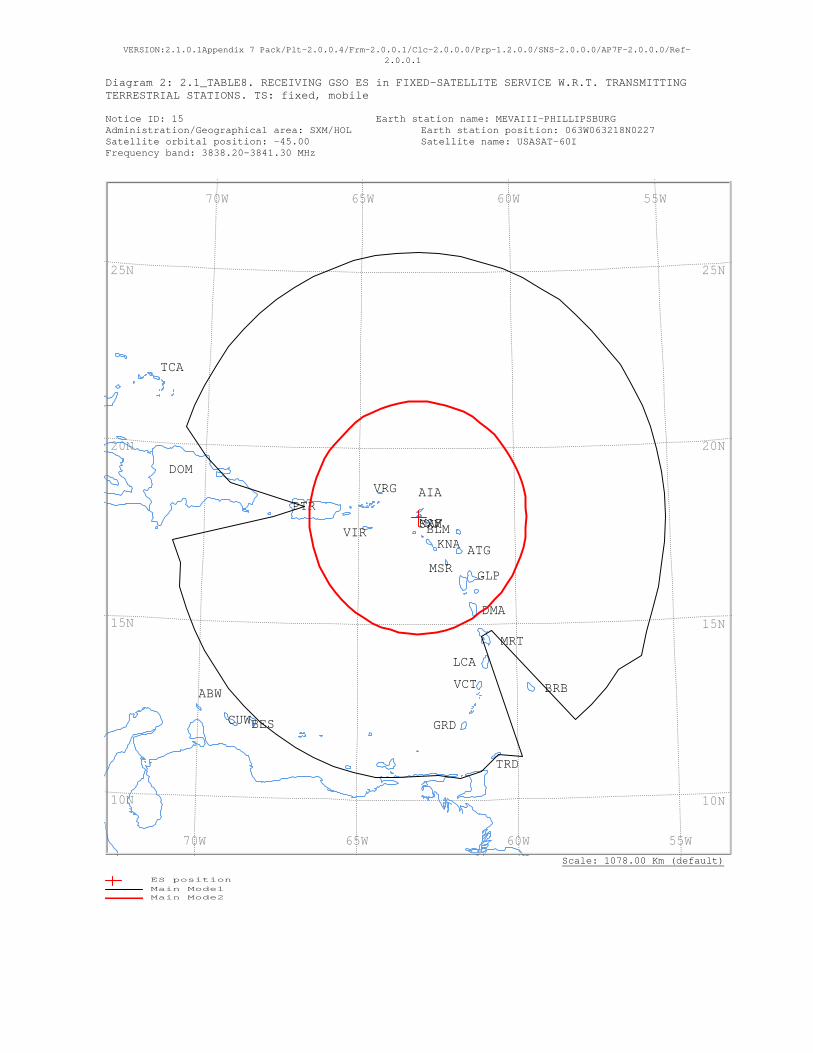
VERSION:2.1.0.1Appendix 7 Pack/Plt-2.0.0.4/Frm-2.0.0.1/Clc-2.0.0.0/Prp-1.2.0.0/SNS-2.0.0.0/AP7F-2.0.0.0/Ref-2.0.0.1
Diagram 2: 2.1_TABLE8. RECEIVING GSO ES in FIXED-SATELLITE SERVICE W.R.T. TRANSMITTING TERRESTRIAL STATIONS. TS: fixed, mobile Notice ID: 15 Earth station name: MEVAIII-PHILLIPSBURG Administration/Geographical area: SXM/HOL Earth station position: 063W063218N0227 Satellite orbital position: -45.00 Satellite name: USASAT-60I Frequency band: 3838.20-3841.30 MHz
Scale: 1078.00 Km (default)
VRG
VIR
VCT
TRD
TCA
SXMPTR
MSR
MRT
MAF
LCA
KNA
GRD
GLP
DOM
DMA
CUW
BRB
BLM
BES
ATG
AIA
ABW
55W 60W 65W 70W
55W 60W 65W 70W
25N
20N
15N
10N
25N
20N
15N
10N
ES positionMain Mode1 Main Mode2
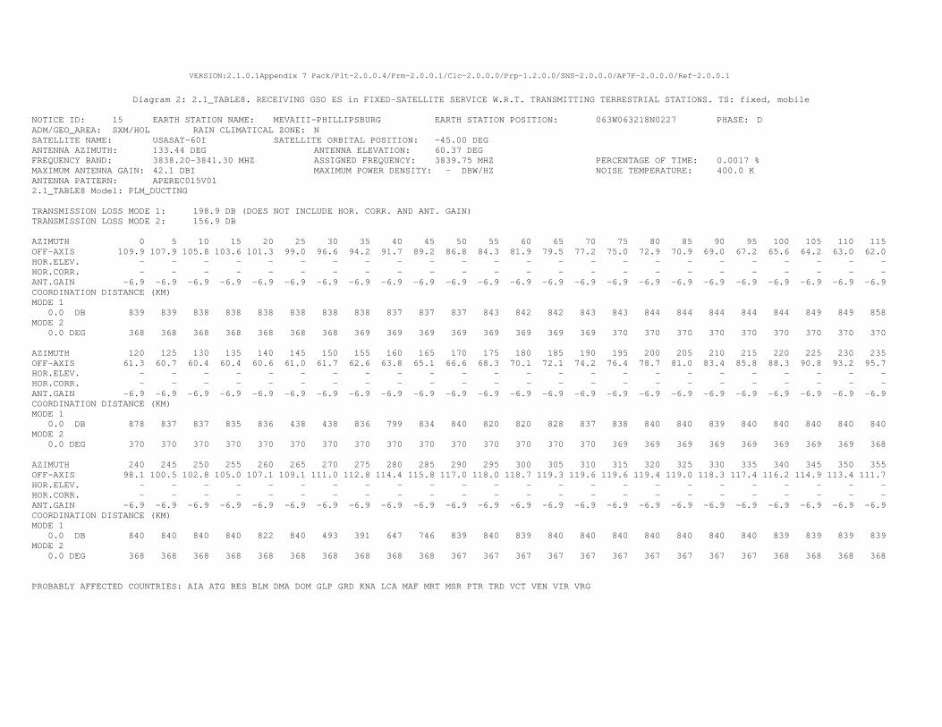
VERSION:2.1.0.1Appendix 7 Pack/Plt-2.0.0.4/Frm-2.0.0.1/Clc-2.0.0.0/Prp-1.2.0.0/SNS-2.0.0.0/AP7F-2.0.0.0/Ref-2.0.0.1
Diagram 2: 2.1_TABLE8. RECEIVING GSO ES in FIXED-SATELLITE SERVICE W.R.T. TRANSMITTING TERRESTRIAL STATIONS. TS: fixed, mobile
NOTICE ID: 15 EARTH STATION NAME: MEVAIII-PHILLIPSBURG EARTH STATION POSITION: 063W063218N0227 PHASE: D ADM/GEO_AREA: SXM/HOL RAIN CLIMATICAL ZONE: N SATELLITE NAME: USASAT-60I SATELLITE ORBITAL POSITION: -45.00 DEG ANTENNA AZIMUTH: 133.44 DEG ANTENNA ELEVATION: 60.37 DEG FREQUENCY BAND: 3838.20-3841.30 MHZ ASSIGNED FREQUENCY: 3839.75 MHZ PERCENTAGE OF TIME: 0.0017 % MAXIMUM ANTENNA GAIN: 42.1 DBI MAXIMUM POWER DENSITY: - DBW/HZ NOISE TEMPERATURE: 400.0 K ANTENNA PATTERN: APEREC015V01 2.1_TABLE8 Model: PLM_DUCTING TRANSMISSION LOSS MODE 1: 198.9 DB (DOES NOT INCLUDE HOR. CORR. AND ANT. GAIN) TRANSMISSION LOSS MODE 2: 156.9 DB AZIMUTH 0 5 10 15 20 25 30 35 40 45 50 55 60 65 70 75 80 85 90 95 100 105 110 115 OFF-AXIS 109.9 107.9 105.8 103.6 101.3 99.0 96.6 94.2 91.7 89.2 86.8 84.3 81.9 79.5 77.2 75.0 72.9 70.9 69.0 67.2 65.6 64.2 63.0 62.0 HOR.ELEV. - - - - - - - - - - - - - - - - - - - - - - - - HOR.CORR. - - - - - - - - - - - - - - - - - - - - - - - - ANT.GAIN -6.9 -6.9 -6.9 -6.9 -6.9 -6.9 -6.9 -6.9 -6.9 -6.9 -6.9 -6.9 -6.9 -6.9 -6.9 -6.9 -6.9 -6.9 -6.9 -6.9 -6.9 -6.9 -6.9 -6.9 COORDINATION DISTANCE (KM) MODE 1 0.0 DB 839 839 838 838 838 838 838 838 837 837 837 843 842 842 843 843 844 844 844 844 844 849 849 858 MODE 2 0.0 DEG 368 368 368 368 368 368 368 369 369 369 369 369 369 369 369 370 370 370 370 370 370 370 370 370 AZIMUTH 120 125 130 135 140 145 150 155 160 165 170 175 180 185 190 195 200 205 210 215 220 225 230 235 OFF-AXIS 61.3 60.7 60.4 60.4 60.6 61.0 61.7 62.6 63.8 65.1 66.6 68.3 70.1 72.1 74.2 76.4 78.7 81.0 83.4 85.8 88.3 90.8 93.2 95.7 HOR.ELEV. - - - - - - - - - - - - - - - - - - - - - - - - HOR.CORR. - - - - - - - - - - - - - - - - - - - - - - - - ANT.GAIN -6.9 -6.9 -6.9 -6.9 -6.9 -6.9 -6.9 -6.9 -6.9 -6.9 -6.9 -6.9 -6.9 -6.9 -6.9 -6.9 -6.9 -6.9 -6.9 -6.9 -6.9 -6.9 -6.9 -6.9 COORDINATION DISTANCE (KM) MODE 1 0.0 DB 878 837 837 835 836 438 438 836 799 834 840 820 820 828 837 838 840 840 839 840 840 840 840 840 MODE 2 0.0 DEG 370 370 370 370 370 370 370 370 370 370 370 370 370 370 370 369 369 369 369 369 369 369 369 368 AZIMUTH 240 245 250 255 260 265 270 275 280 285 290 295 300 305 310 315 320 325 330 335 340 345 350 355 OFF-AXIS 98.1 100.5 102.8 105.0 107.1 109.1 111.0 112.8 114.4 115.8 117.0 118.0 118.7 119.3 119.6 119.6 119.4 119.0 118.3 117.4 116.2 114.9 113.4 111.7 HOR.ELEV. - - - - - - - - - - - - - - - - - - - - - - - - HOR.CORR. - - - - - - - - - - - - - - - - - - - - - - - - ANT.GAIN -6.9 -6.9 -6.9 -6.9 -6.9 -6.9 -6.9 -6.9 -6.9 -6.9 -6.9 -6.9 -6.9 -6.9 -6.9 -6.9 -6.9 -6.9 -6.9 -6.9 -6.9 -6.9 -6.9 -6.9 COORDINATION DISTANCE (KM) MODE 1 0.0 DB 840 840 840 840 822 840 493 391 647 746 839 840 839 840 840 840 840 840 840 840 839 839 839 839 MODE 2 0.0 DEG 368 368 368 368 368 368 368 368 368 368 367 367 367 367 367 367 367 367 367 367 368 368 368 368 PROBABLY AFFECTED COUNTRIES: AIA ATG BES BLM DMA DOM GLP GRD KNA LCA MAF MRT MSR PTR TRD VCT VEN VIR VRG

VERSION:2.1.0.1Appendix 7 Pack/Plt-2.0.0.4/Frm-2.0.0.1/Clc-2.0.0.0/Prp-1.2.0.0/SNS-2.0.0.0/AP7F-2.0.0.0/Ref-2.0.0.1
Diagram 1: 2.1_TABLE7. TRANSMITTING GSO ES in FIXED-SATELLITE SERVICE W.R.T. RECEIVING TERRESTRIAL STATIONS. TS: fixed, mobile Notice ID: 14 Earth station name: MEVAIII-PANAMA CITY Administration/Geographical area: PNR/PNR Earth station position: 079W230109N0417 Satellite orbital position: -45.00 Satellite name: USASAT-60I Frequency band: 6063.20-6066.30 MHz
Scale: 416.00 Km (default)
PNR
CLM
80W
80W
10N10N
ES positionMain Mode1 Main Mode2

ANALYSIS DATE AND TIME: 2014-11-27 12:16:08
VERSION: 2.1.0.1Appendix 7 Pack/Plt-2.0.0.4/Frm-2.0.0.1/Clc-2.0.0.0/Prp-1.2.0.0/SNS-2.0.0.0/AP7F-2.0.0.0/Ref-2.0.0.1
Diagram 1: 2.1_TABLE7. TRANSMITTING GSO ES in FIXED-SATELLITE SERVICE W.R.T. RECEIVING TERRESTRIAL STATIONS. TS: fixed, mobile
NOTICE ID: 14 EARTH STATION NAME: MEVAIII-PANAMA CITY EARTH STATION POSITION: 079W230109N0417 PHASE: D ADM/GEO_AREA: PNR/PNR RAIN CLIMATICAL ZONE: P SATELLITE NAME: USASAT-60I SATELLITE ORBITAL POSITION: -45.00 DEG ANTENNA AZIMUTH: 102.97 DEG ANTENNA ELEVATION: 48.88 DEG FREQUENCY BAND: 6063.20-6066.30 MHZ ASSIGNED FREQUENCY: 6064.75 MHZ PERCENTAGE OF TIME: 0.0050 % MAXIMUM ANTENNA GAIN: 49.0 DBI MAXIMUM POWER DENSITY: -53.1 DBW/HZ NOISE TEMPERATURE: - K ANTENNA PATTERN: APEREC015V01 2.1_TABLE7 Model: PLM_DUCTING TRANSMISSION LOSS MODE 1: 159.9 DB (DOES NOT INCLUDE HOR. CORR. AND ANT. GAIN) TRANSMISSION LOSS MODE 2: 113.9 DB AZIMUTH 0 5 10 15 20 25 30 35 40 45 50 55 60 65 70 75 80 85 90 95 100 105 110 115 OFF-AXIS 98.5 95.2 92.0 88.7 85.4 82.1 78.9 75.7 72.6 69.6 66.7 63.9 61.2 58.8 56.5 54.5 52.7 51.3 50.1 49.4 48.9 48.9 49.3 50.0 HOR.ELEV. - - - - - - - - - - - - - - - - - - - - - - - - HOR.CORR. - - - - - - - - - - - - - - - - - - - - - - - - ANT.GAIN -10.0 -10.0 -10.0 -10.0 -10.0 -10.0 -10.0 -10.0 -10.0 -10.0 -10.0 -10.0 -10.0 -10.0 -10.0 -10.0 -10.0 -10.0 -10.0 -10.0 -10.0 -10.0 -10.0 -10.0 COORDINATION DISTANCE (KM) MODE 1 0.0 DB 174 175 175 175 174 175 179 179 177 177 180 175 174 178 182 183 181 181 176 175 174 176 193 190 MODE 2 0.0 DEG 115 115 115 115 115 115 116 116 116 116 116 116 117 117 117 117 117 117 117 117 117 117 117 117 AZIMUTH 120 125 130 135 140 145 150 155 160 165 170 175 180 185 190 195 200 205 210 215 220 225 230 235 OFF-AXIS 51.0 52.4 54.1 56.1 58.3 60.8 63.4 66.1 69.0 72.0 75.1 78.3 81.5 84.8 88.0 91.3 94.6 97.9 101.1 104.3 107.4 110.4 113.3 116.1 HOR.ELEV. - - - - - - - - - - - - - - - - - - - - - - - - HOR.CORR. - - - - - - - - - - - - - - - - - - - - - - - - ANT.GAIN -10.0 -10.0 -10.0 -10.0 -10.0 -10.0 -10.0 -10.0 -10.0 -10.0 -10.0 -10.0 -10.0 -10.0 -10.0 -10.0 -10.0 -10.0 -10.0 -10.0 -10.0 -10.0 -10.0 -10.0 COORDINATION DISTANCE (KM) MODE 1 0.0 DB 212 206 192 205 203 215 216 216 216 216 216 216 216 216 216 216 216 210 200 198 208 206 185 175 MODE 2 0.0 DEG 117 117 117 117 117 117 116 116 116 116 116 116 115 115 115 115 115 115 115 115 115 115 115 115 AZIMUTH 240 245 250 255 260 265 270 275 280 285 290 295 300 305 310 315 320 325 330 335 340 345 350 355 OFF-AXIS 118.8 121.2 123.5 125.5 127.3 128.7 129.9 130.6 131.1 131.1 130.7 130.0 129.0 127.6 125.9 123.9 121.7 119.2 116.6 113.9 111.0 108.0 104.9 101.7 HOR.ELEV. - - - - - - - - - - - - - - - - - - - - - - - - HOR.CORR. - - - - - - - - - - - - - - - - - - - - - - - - ANT.GAIN -10.0 -10.0 -10.0 -10.0 -10.0 -10.0 -10.0 -10.0 -10.0 -10.0 -10.0 -10.0 -10.0 -10.0 -10.0 -10.0 -10.0 -10.0 -10.0 -10.0 -10.0 -10.0 -10.0 -10.0 COORDINATION DISTANCE (KM) MODE 1 0.0 DB 174 174 174 174 184 202 199 193 198 192 199 200 196 194 192 191 182 181 174 174 174 174 174 174 MODE 2 0.0 DEG 115 115 115 115 115 115 115 115 115 115 115 115 115 115 115 115 115 115 115 115 115 115 115 115 PROBABLY AFFECTED COUNTRIES:
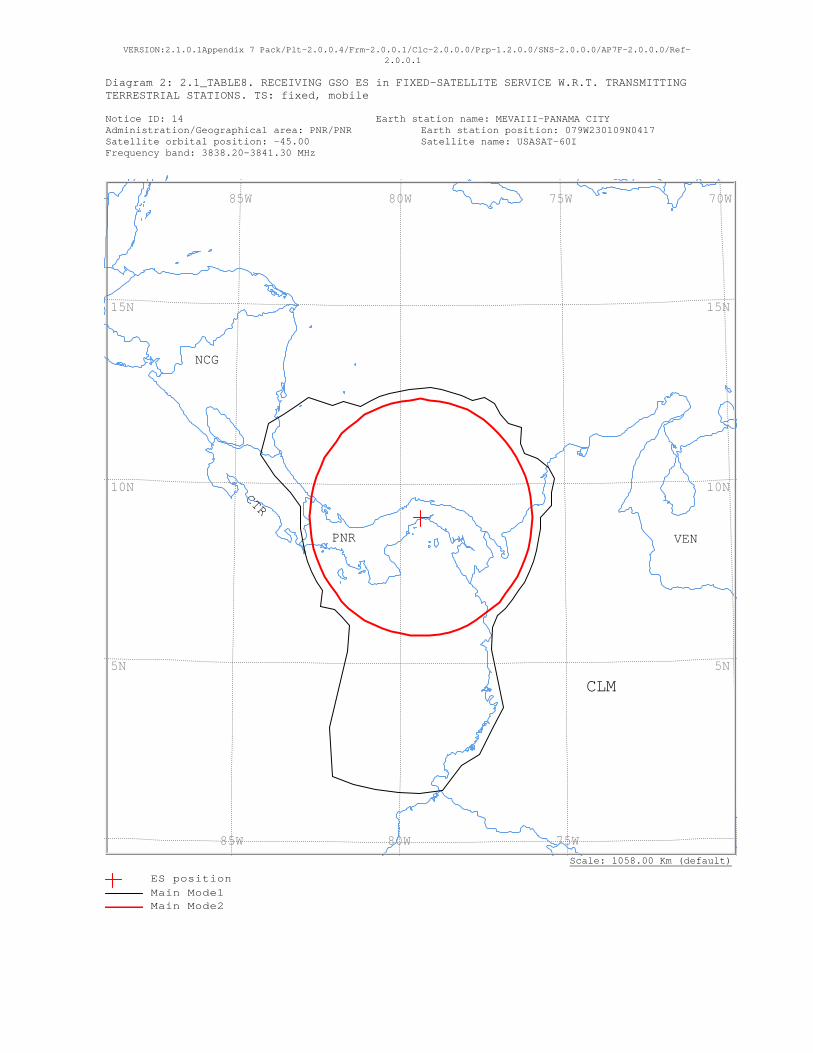
VERSION:2.1.0.1Appendix 7 Pack/Plt-2.0.0.4/Frm-2.0.0.1/Clc-2.0.0.0/Prp-1.2.0.0/SNS-2.0.0.0/AP7F-2.0.0.0/Ref-2.0.0.1
Diagram 2: 2.1_TABLE8. RECEIVING GSO ES in FIXED-SATELLITE SERVICE W.R.T. TRANSMITTING TERRESTRIAL STATIONS. TS: fixed, mobile Notice ID: 14 Earth station name: MEVAIII-PANAMA CITY Administration/Geographical area: PNR/PNR Earth station position: 079W230109N0417 Satellite orbital position: -45.00 Satellite name: USASAT-60I Frequency band: 3838.20-3841.30 MHz
Scale: 1058.00 Km (default)
VENPNR
NCG
CTR
CLM
70W 75W 80W 85W
75W 80W 85W
15N
10N
5N
15N
10N
5N
ES positionMain Mode1 Main Mode2
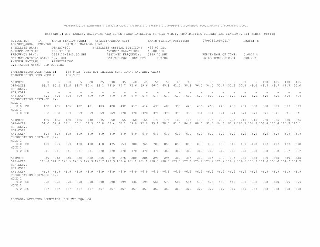
VERSION:2.1.0.1Appendix 7 Pack/Plt-2.0.0.4/Frm-2.0.0.1/Clc-2.0.0.0/Prp-1.2.0.0/SNS-2.0.0.0/AP7F-2.0.0.0/Ref-2.0.0.1
Diagram 2: 2.1_TABLE8. RECEIVING GSO ES in FIXED-SATELLITE SERVICE W.R.T. TRANSMITTING TERRESTRIAL STATIONS. TS: fixed, mobile
NOTICE ID: 14 EARTH STATION NAME: MEVAIII-PANAMA CITY EARTH STATION POSITION: 079W230109N0417 PHASE: D ADM/GEO_AREA: PNR/PNR RAIN CLIMATICAL ZONE: P SATELLITE NAME: USASAT-60I SATELLITE ORBITAL POSITION: -45.00 DEG ANTENNA AZIMUTH: 102.97 DEG ANTENNA ELEVATION: 48.88 DEG FREQUENCY BAND: 3838.20-3841.30 MHZ ASSIGNED FREQUENCY: 3839.75 MHZ PERCENTAGE OF TIME: 0.0017 % MAXIMUM ANTENNA GAIN: 42.1 DBI MAXIMUM POWER DENSITY: - DBW/HZ NOISE TEMPERATURE: 400.0 K ANTENNA PATTERN: APEREC015V01 2.1_TABLE8 Model: PLM_DUCTING TRANSMISSION LOSS MODE 1: 198.9 DB (DOES NOT INCLUDE HOR. CORR. AND ANT. GAIN) TRANSMISSION LOSS MODE 2: 156.9 DB AZIMUTH 0 5 10 15 20 25 30 35 40 45 50 55 60 65 70 75 80 85 90 95 100 105 110 115 OFF-AXIS 98.5 95.2 92.0 88.7 85.4 82.1 78.9 75.7 72.6 69.6 66.7 63.9 61.2 58.8 56.5 54.5 52.7 51.3 50.1 49.4 48.9 48.9 49.3 50.0 HOR.ELEV. - - - - - - - - - - - - - - - - - - - - - - - - HOR.CORR. - - - - - - - - - - - - - - - - - - - - - - - - ANT.GAIN -6.9 -6.9 -6.9 -6.9 -6.9 -6.9 -6.9 -6.9 -6.9 -6.9 -6.9 -6.9 -6.9 -6.9 -6.9 -6.9 -6.9 -6.9 -6.9 -6.9 -6.9 -6.9 -6.9 -6.9 COORDINATION DISTANCE (KM) MODE 1 0.0 DB 400 405 405 402 401 403 428 432 417 414 437 405 398 428 456 463 443 438 401 398 398 399 399 399 MODE 2 0.0 DEG 368 368 369 369 369 369 369 370 370 370 370 370 370 370 371 371 371 371 371 371 371 371 371 371 AZIMUTH 120 125 130 135 140 145 150 155 160 165 170 175 180 185 190 195 200 205 210 215 220 225 230 235 OFF-AXIS 51.0 52.4 54.1 56.1 58.3 60.8 63.4 66.1 69.0 72.0 75.1 78.3 81.5 84.8 88.0 91.3 94.6 97.9 101.1 104.3 107.4 110.4 113.3 116.1 HOR.ELEV. - - - - - - - - - - - - - - - - - - - - - - - - HOR.CORR. - - - - - - - - - - - - - - - - - - - - - - - - ANT.GAIN -6.9 -6.9 -6.9 -6.9 -6.9 -6.9 -6.9 -6.9 -6.9 -6.9 -6.9 -6.9 -6.9 -6.9 -6.9 -6.9 -6.9 -6.9 -6.9 -6.9 -6.9 -6.9 -6.9 -6.9 COORDINATION DISTANCE (KM) MODE 1 0.0 DB 400 399 399 400 400 418 475 653 700 765 783 853 858 858 858 858 858 719 483 408 403 403 433 398 MODE 2 0.0 DEG 371 371 371 371 371 370 370 370 370 370 370 369 369 369 369 369 369 368 368 368 368 368 367 367 AZIMUTH 240 245 250 255 260 265 270 275 280 285 290 295 300 305 310 315 320 325 330 335 340 345 350 355 OFF-AXIS 118.8 121.2 123.5 125.5 127.3 128.7 129.9 130.6 131.1 131.1 130.7 130.0 129.0 127.6 125.9 123.9 121.7 119.2 116.6 113.9 111.0 108.0 104.9 101.7 HOR.ELEV. - - - - - - - - - - - - - - - - - - - - - - - - HOR.CORR. - - - - - - - - - - - - - - - - - - - - - - - - ANT.GAIN -6.9 -6.9 -6.9 -6.9 -6.9 -6.9 -6.9 -6.9 -6.9 -6.9 -6.9 -6.9 -6.9 -6.9 -6.9 -6.9 -6.9 -6.9 -6.9 -6.9 -6.9 -6.9 -6.9 -6.9 COORDINATION DISTANCE (KM) MODE 1 0.0 DB 398 398 398 398 398 398 398 399 436 499 566 573 586 554 539 525 456 443 398 398 398 400 399 399 MODE 2 0.0 DEG 367 367 367 367 367 367 367 367 367 367 367 367 367 367 367 367 367 367 367 367 368 368 368 368 PROBABLY AFFECTED COUNTRIES: CLM CTR EQA NCG
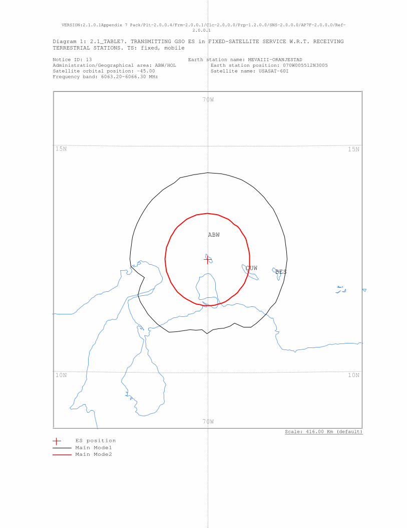
VERSION:2.1.0.1Appendix 7 Pack/Plt-2.0.0.4/Frm-2.0.0.1/Clc-2.0.0.0/Prp-1.2.0.0/SNS-2.0.0.0/AP7F-2.0.0.0/Ref-2.0.0.1
Diagram 1: 2.1_TABLE7. TRANSMITTING GSO ES in FIXED-SATELLITE SERVICE W.R.T. RECEIVING TERRESTRIAL STATIONS. TS: fixed, mobile Notice ID: 13 Earth station name: MEVAIII-ORANJESTAD Administration/Geographical area: ABW/HOL Earth station position: 070W005512N3005 Satellite orbital position: -45.00 Satellite name: USASAT-60I Frequency band: 6063.20-6066.30 MHz
Scale: 416.00 Km (default)
CUW BES
ABW
70W
70W
15N
10N
15N
10N
ES positionMain Mode1 Main Mode2
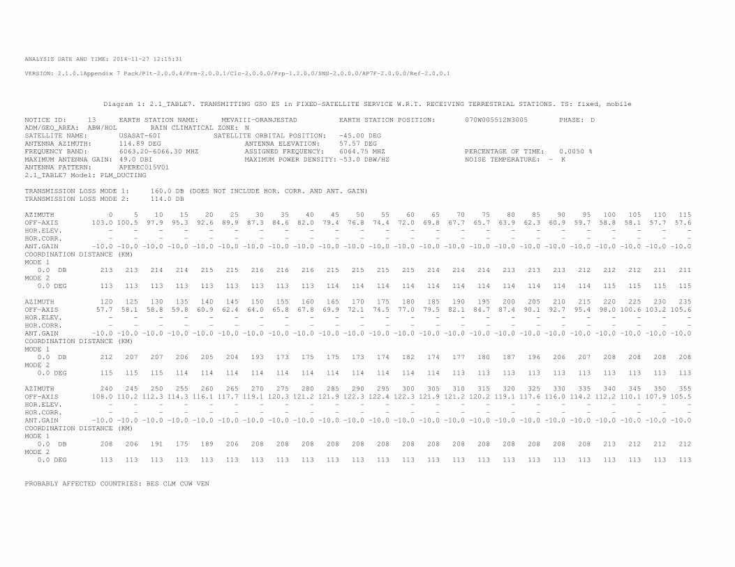
ANALYSIS DATE AND TIME: 2014-11-27 12:15:31
VERSION: 2.1.0.1Appendix 7 Pack/Plt-2.0.0.4/Frm-2.0.0.1/Clc-2.0.0.0/Prp-1.2.0.0/SNS-2.0.0.0/AP7F-2.0.0.0/Ref-2.0.0.1
Diagram 1: 2.1_TABLE7. TRANSMITTING GSO ES in FIXED-SATELLITE SERVICE W.R.T. RECEIVING TERRESTRIAL STATIONS. TS: fixed, mobile
NOTICE ID: 13 EARTH STATION NAME: MEVAIII-ORANJESTAD EARTH STATION POSITION: 070W005512N3005 PHASE: D ADM/GEO_AREA: ABW/HOL RAIN CLIMATICAL ZONE: N SATELLITE NAME: USASAT-60I SATELLITE ORBITAL POSITION: -45.00 DEG ANTENNA AZIMUTH: 114.89 DEG ANTENNA ELEVATION: 57.57 DEG FREQUENCY BAND: 6063.20-6066.30 MHZ ASSIGNED FREQUENCY: 6064.75 MHZ PERCENTAGE OF TIME: 0.0050 % MAXIMUM ANTENNA GAIN: 49.0 DBI MAXIMUM POWER DENSITY: -53.0 DBW/HZ NOISE TEMPERATURE: - K ANTENNA PATTERN: APEREC015V01 2.1_TABLE7 Model: PLM_DUCTING TRANSMISSION LOSS MODE 1: 160.0 DB (DOES NOT INCLUDE HOR. CORR. AND ANT. GAIN) TRANSMISSION LOSS MODE 2: 114.0 DB AZIMUTH 0 5 10 15 20 25 30 35 40 45 50 55 60 65 70 75 80 85 90 95 100 105 110 115 OFF-AXIS 103.0 100.5 97.9 95.3 92.6 89.9 87.3 84.6 82.0 79.4 76.8 74.4 72.0 69.8 67.7 65.7 63.9 62.3 60.9 59.7 58.8 58.1 57.7 57.6 HOR.ELEV. - - - - - - - - - - - - - - - - - - - - - - - - HOR.CORR. - - - - - - - - - - - - - - - - - - - - - - - - ANT.GAIN -10.0 -10.0 -10.0 -10.0 -10.0 -10.0 -10.0 -10.0 -10.0 -10.0 -10.0 -10.0 -10.0 -10.0 -10.0 -10.0 -10.0 -10.0 -10.0 -10.0 -10.0 -10.0 -10.0 -10.0 COORDINATION DISTANCE (KM) MODE 1 0.0 DB 213 213 214 214 215 215 216 216 216 215 215 215 215 214 214 214 213 213 213 212 212 212 211 211 MODE 2 0.0 DEG 113 113 113 113 113 113 113 113 113 114 114 114 114 114 114 114 114 114 114 114 115 115 115 115 AZIMUTH 120 125 130 135 140 145 150 155 160 165 170 175 180 185 190 195 200 205 210 215 220 225 230 235 OFF-AXIS 57.7 58.1 58.8 59.8 60.9 62.4 64.0 65.8 67.8 69.9 72.1 74.5 77.0 79.5 82.1 84.7 87.4 90.1 92.7 95.4 98.0 100.6 103.2 105.6 HOR.ELEV. - - - - - - - - - - - - - - - - - - - - - - - - HOR.CORR. - - - - - - - - - - - - - - - - - - - - - - - - ANT.GAIN -10.0 -10.0 -10.0 -10.0 -10.0 -10.0 -10.0 -10.0 -10.0 -10.0 -10.0 -10.0 -10.0 -10.0 -10.0 -10.0 -10.0 -10.0 -10.0 -10.0 -10.0 -10.0 -10.0 -10.0 COORDINATION DISTANCE (KM) MODE 1 0.0 DB 212 207 207 206 205 204 193 173 175 175 173 174 182 174 177 180 187 196 206 207 208 208 208 208 MODE 2 0.0 DEG 115 115 115 114 114 114 114 114 114 114 114 114 114 114 113 113 113 113 113 113 113 113 113 113 AZIMUTH 240 245 250 255 260 265 270 275 280 285 290 295 300 305 310 315 320 325 330 335 340 345 350 355 OFF-AXIS 108.0 110.2 112.3 114.3 116.1 117.7 119.1 120.3 121.2 121.9 122.3 122.4 122.3 121.9 121.2 120.2 119.1 117.6 116.0 114.2 112.2 110.1 107.9 105.5 HOR.ELEV. - - - - - - - - - - - - - - - - - - - - - - - - HOR.CORR. - - - - - - - - - - - - - - - - - - - - - - - - ANT.GAIN -10.0 -10.0 -10.0 -10.0 -10.0 -10.0 -10.0 -10.0 -10.0 -10.0 -10.0 -10.0 -10.0 -10.0 -10.0 -10.0 -10.0 -10.0 -10.0 -10.0 -10.0 -10.0 -10.0 -10.0 COORDINATION DISTANCE (KM) MODE 1 0.0 DB 208 206 191 175 189 206 208 208 208 208 208 208 208 208 208 208 208 208 208 208 213 212 212 212 MODE 2 0.0 DEG 113 113 113 113 113 113 113 113 113 113 113 113 113 113 113 113 113 113 113 113 113 113 113 113 PROBABLY AFFECTED COUNTRIES: BES CLM CUW VEN
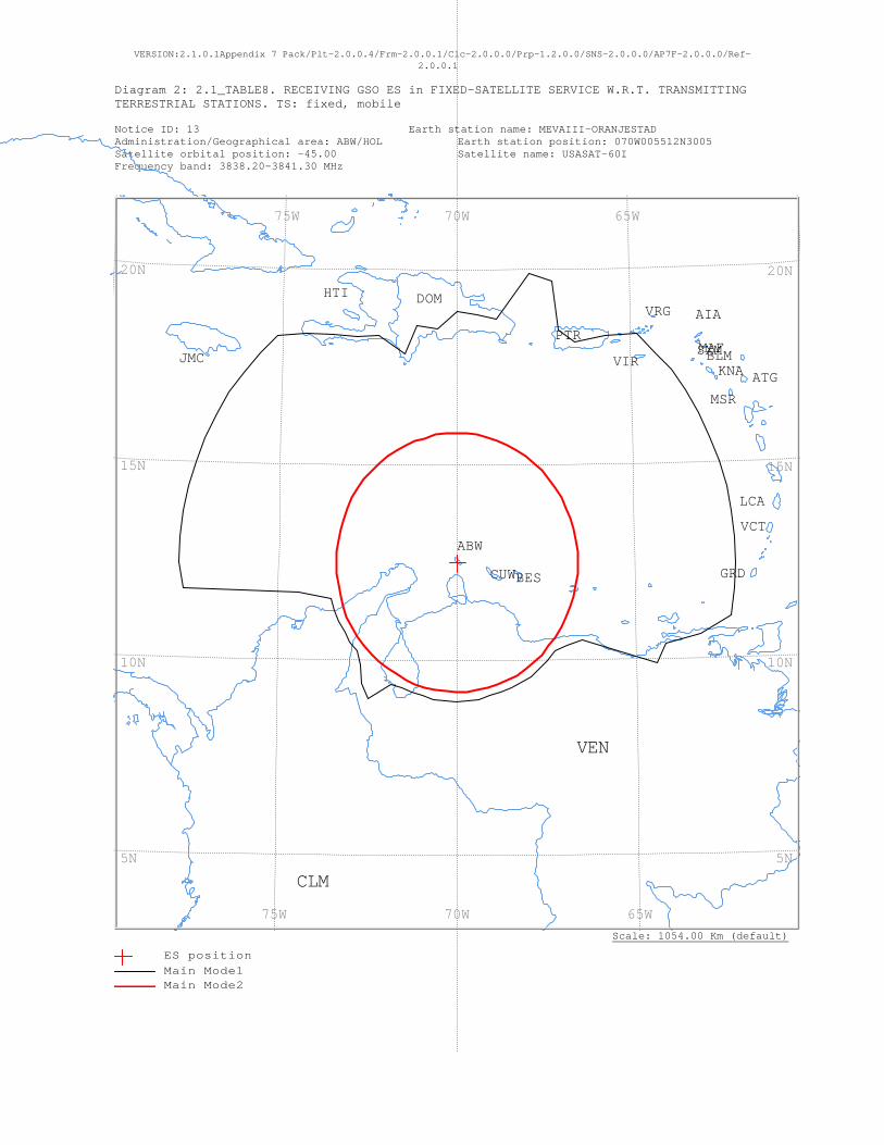
VERSION:2.1.0.1Appendix 7 Pack/Plt-2.0.0.4/Frm-2.0.0.1/Clc-2.0.0.0/Prp-1.2.0.0/SNS-2.0.0.0/AP7F-2.0.0.0/Ref-2.0.0.1
Diagram 2: 2.1_TABLE8. RECEIVING GSO ES in FIXED-SATELLITE SERVICE W.R.T. TRANSMITTING TERRESTRIAL STATIONS. TS: fixed, mobile Notice ID: 13 Earth station name: MEVAIII-ORANJESTAD Administration/Geographical area: ABW/HOL Earth station position: 070W005512N3005 Satellite orbital position: -45.00 Satellite name: USASAT-60I Frequency band: 3838.20-3841.30 MHz
Scale: 1054.00 Km (default)
VRG
VIR
VEN
VCT
SXMPTR
MSR
MAF
LCA
KNAJMC
HTI
GRD
DOM
CUW
CLM
BLM
BES
ATG
AIA
ABW
65W 70W 75W
65W 70W 75W
20N
15N
10N
5N
20N
15N
10N
5N
ES positionMain Mode1 Main Mode2
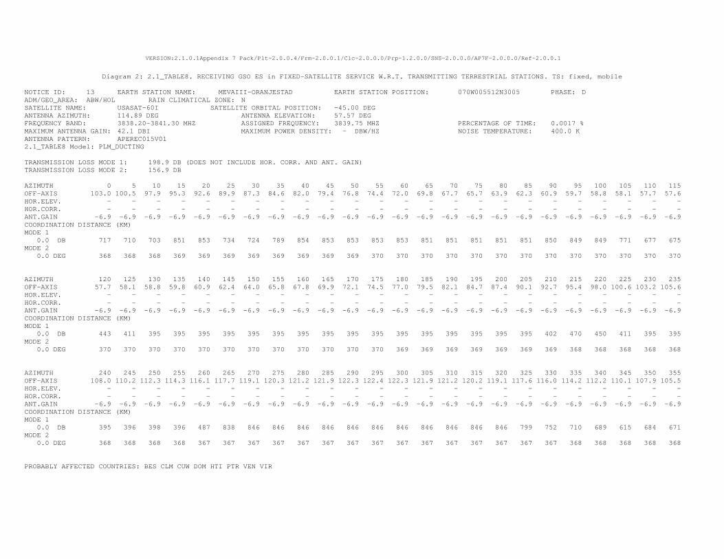
VERSION:2.1.0.1Appendix 7 Pack/Plt-2.0.0.4/Frm-2.0.0.1/Clc-2.0.0.0/Prp-1.2.0.0/SNS-2.0.0.0/AP7F-2.0.0.0/Ref-2.0.0.1
Diagram 2: 2.1_TABLE8. RECEIVING GSO ES in FIXED-SATELLITE SERVICE W.R.T. TRANSMITTING TERRESTRIAL STATIONS. TS: fixed, mobile
NOTICE ID: 13 EARTH STATION NAME: MEVAIII-ORANJESTAD EARTH STATION POSITION: 070W005512N3005 PHASE: D ADM/GEO_AREA: ABW/HOL RAIN CLIMATICAL ZONE: N SATELLITE NAME: USASAT-60I SATELLITE ORBITAL POSITION: -45.00 DEG ANTENNA AZIMUTH: 114.89 DEG ANTENNA ELEVATION: 57.57 DEG FREQUENCY BAND: 3838.20-3841.30 MHZ ASSIGNED FREQUENCY: 3839.75 MHZ PERCENTAGE OF TIME: 0.0017 % MAXIMUM ANTENNA GAIN: 42.1 DBI MAXIMUM POWER DENSITY: - DBW/HZ NOISE TEMPERATURE: 400.0 K ANTENNA PATTERN: APEREC015V01 2.1_TABLE8 Model: PLM_DUCTING TRANSMISSION LOSS MODE 1: 198.9 DB (DOES NOT INCLUDE HOR. CORR. AND ANT. GAIN) TRANSMISSION LOSS MODE 2: 156.9 DB AZIMUTH 0 5 10 15 20 25 30 35 40 45 50 55 60 65 70 75 80 85 90 95 100 105 110 115 OFF-AXIS 103.0 100.5 97.9 95.3 92.6 89.9 87.3 84.6 82.0 79.4 76.8 74.4 72.0 69.8 67.7 65.7 63.9 62.3 60.9 59.7 58.8 58.1 57.7 57.6 HOR.ELEV. - - - - - - - - - - - - - - - - - - - - - - - - HOR.CORR. - - - - - - - - - - - - - - - - - - - - - - - - ANT.GAIN -6.9 -6.9 -6.9 -6.9 -6.9 -6.9 -6.9 -6.9 -6.9 -6.9 -6.9 -6.9 -6.9 -6.9 -6.9 -6.9 -6.9 -6.9 -6.9 -6.9 -6.9 -6.9 -6.9 -6.9 COORDINATION DISTANCE (KM) MODE 1 0.0 DB 717 710 703 851 853 734 724 789 854 853 853 853 853 851 851 851 851 851 850 849 849 771 677 675 MODE 2 0.0 DEG 368 368 368 369 369 369 369 369 369 369 369 370 370 370 370 370 370 370 370 370 370 370 370 370 AZIMUTH 120 125 130 135 140 145 150 155 160 165 170 175 180 185 190 195 200 205 210 215 220 225 230 235 OFF-AXIS 57.7 58.1 58.8 59.8 60.9 62.4 64.0 65.8 67.8 69.9 72.1 74.5 77.0 79.5 82.1 84.7 87.4 90.1 92.7 95.4 98.0 100.6 103.2 105.6 HOR.ELEV. - - - - - - - - - - - - - - - - - - - - - - - - HOR.CORR. - - - - - - - - - - - - - - - - - - - - - - - - ANT.GAIN -6.9 -6.9 -6.9 -6.9 -6.9 -6.9 -6.9 -6.9 -6.9 -6.9 -6.9 -6.9 -6.9 -6.9 -6.9 -6.9 -6.9 -6.9 -6.9 -6.9 -6.9 -6.9 -6.9 -6.9 COORDINATION DISTANCE (KM) MODE 1 0.0 DB 443 411 395 395 395 395 395 395 395 395 395 395 395 395 395 395 395 395 402 470 450 411 395 395 MODE 2 0.0 DEG 370 370 370 370 370 370 370 370 370 370 370 370 369 369 369 369 369 369 369 368 368 368 368 368 AZIMUTH 240 245 250 255 260 265 270 275 280 285 290 295 300 305 310 315 320 325 330 335 340 345 350 355 OFF-AXIS 108.0 110.2 112.3 114.3 116.1 117.7 119.1 120.3 121.2 121.9 122.3 122.4 122.3 121.9 121.2 120.2 119.1 117.6 116.0 114.2 112.2 110.1 107.9 105.5 HOR.ELEV. - - - - - - - - - - - - - - - - - - - - - - - - HOR.CORR. - - - - - - - - - - - - - - - - - - - - - - - - ANT.GAIN -6.9 -6.9 -6.9 -6.9 -6.9 -6.9 -6.9 -6.9 -6.9 -6.9 -6.9 -6.9 -6.9 -6.9 -6.9 -6.9 -6.9 -6.9 -6.9 -6.9 -6.9 -6.9 -6.9 -6.9 COORDINATION DISTANCE (KM) MODE 1 0.0 DB 395 396 398 396 487 838 846 846 846 846 846 846 846 846 846 846 846 799 752 710 689 615 684 671 MODE 2 0.0 DEG 368 368 368 368 367 367 367 367 367 367 367 367 367 367 367 367 367 367 367 368 368 368 368 368 PROBABLY AFFECTED COUNTRIES: BES CLM CUW DOM HTI PTR VEN VIR

VERSION:2.1.0.1Appendix 7 Pack/Plt-2.0.0.4/Frm-2.0.0.1/Clc-2.0.0.0/Prp-1.2.0.0/SNS-2.0.0.0/AP7F-2.0.0.0/Ref-2.0.0.1
Diagram 1: 2.1_TABLE7. TRANSMITTING GSO ES in FIXED-SATELLITE SERVICE W.R.T. RECEIVING TERRESTRIAL STATIONS. TS: fixed, mobile Notice ID: 12 Earth station name: MEVAIII-MERIDA Administration/Geographical area: MEX/MEX Earth station position: 089W392820N5613 Satellite orbital position: -45.00 Satellite name: USASAT-60I Frequency band: 6063.20-6066.30 MHz
Scale: 402.00 Km (default)
MEX
BLZ
90W
90W
20N20N
ES positionMain Mode1 Main Mode2
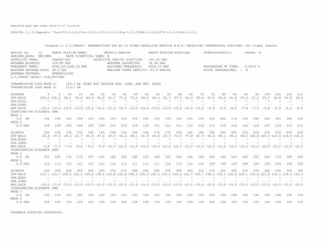
ANALYSIS DATE AND TIME: 2014-11-27 12:14:06
VERSION: 2.1.0.1Appendix 7 Pack/Plt-2.0.0.4/Frm-2.0.0.1/Clc-2.0.0.0/Prp-1.2.0.0/SNS-2.0.0.0/AP7F-2.0.0.0/Ref-2.0.0.1
Diagram 1: 2.1_TABLE7. TRANSMITTING GSO ES in FIXED-SATELLITE SERVICE W.R.T. RECEIVING TERRESTRIAL STATIONS. TS: fixed, mobile
NOTICE ID: 12 EARTH STATION NAME: MEVAIII-MERIDA EARTH STATION POSITION: 089W392820N5613 PHASE: D ADM/GEO_AREA: MEX/MEX RAIN CLIMATICAL ZONE: N SATELLITE NAME: USASAT-60I SATELLITE ORBITAL POSITION: -45.00 DEG ANTENNA AZIMUTH: 109.88 DEG ANTENNA ELEVATION: 34.48 DEG FREQUENCY BAND: 6063.20-6066.30 MHZ ASSIGNED FREQUENCY: 6064.75 MHZ PERCENTAGE OF TIME: 0.0050 % MAXIMUM ANTENNA GAIN: 49.0 DBI MAXIMUM POWER DENSITY: -53.9 DBW/HZ NOISE TEMPERATURE: - K ANTENNA PATTERN: APEREC015V01 2.1_TABLE7 Model: PLM_DUCTING TRANSMISSION LOSS MODE 1: 159.1 DB (DOES NOT INCLUDE HOR. CORR. AND ANT. GAIN) TRANSMISSION LOSS MODE 2: 113.1 DB AZIMUTH 0 5 10 15 20 25 30 35 40 45 50 55 60 65 70 75 80 85 90 95 100 105 110 115 OFF-AXIS 106.3 102.2 98.1 94.0 89.9 85.8 81.7 77.6 73.5 69.5 65.6 61.7 57.9 54.3 50.8 47.5 44.4 41.6 39.2 37.2 35.7 34.8 34.5 34.8 HOR.ELEV. - - - - - - - - - - - - - - - - - - - - - - - - HOR.CORR. - - - - - - - - - - - - - - - - - - - - - - - - ANT.GAIN -10.0 -10.0 -10.0 -10.0 -10.0 -10.0 -10.0 -10.0 -10.0 -10.0 -10.0 -10.0 -10.0 -10.0 -10.0 -9.9 -9.2 -8.5 -7.8 -7.3 -6.8 -6.5 -6.4 -6.5 COORDINATION DISTANCE (KM) MODE 1 0.0 DB 194 194 194 194 193 193 193 193 193 193 193 193 193 193 193 194 202 172 176 180 183 185 186 185 MODE 2 0.0 DEG 109 109 109 109 109 109 110 110 110 110 111 111 111 112 112 112 112 112 112 113 113 113 113 113 AZIMUTH 120 125 130 135 140 145 150 155 160 165 170 175 180 185 190 195 200 205 210 215 220 225 230 235 OFF-AXIS 35.8 37.3 39.3 41.7 44.5 47.6 50.9 54.4 58.1 61.9 65.8 69.7 73.7 77.8 81.9 86.0 90.1 94.2 98.3 102.4 106.5 110.5 114.4 118.3 HOR.ELEV. - - - - - - - - - - - - - - - - - - - - - - - - HOR.CORR. - - - - - - - - - - - - - - - - - - - - - - - - ANT.GAIN -6.8 -7.3 -7.9 -8.5 -9.2 -9.9 -10.0 -10.0 -10.0 -10.0 -10.0 -10.0 -10.0 -10.0 -10.0 -10.0 -10.0 -10.0 -10.0 -10.0 -10.0 -10.0 -10.0 -10.0 COORDINATION DISTANCE (KM) MODE 1 0.0 DB 183 180 176 172 167 162 162 162 162 162 162 162 162 162 162 162 162 162 162 162 163 173 189 193 MODE 2 0.0 DEG 113 113 112 112 112 112 112 112 111 111 111 110 110 110 110 109 109 109 109 109 109 109 109 109 AZIMUTH 240 245 250 255 260 265 270 275 280 285 290 295 300 305 310 315 320 325 330 335 340 345 350 355 OFF-AXIS 122.1 125.7 129.2 132.5 135.6 138.4 140.8 142.8 144.3 145.2 145.5 145.2 144.2 142.7 140.7 138.3 135.5 132.4 129.1 125.6 121.9 118.1 114.2 110.3 HOR.ELEV. - - - - - - - - - - - - - - - - - - - - - - - - HOR.CORR. - - - - - - - - - - - - - - - - - - - - - - - - ANT.GAIN -10.0 -10.0 -10.0 -10.0 -10.0 -10.0 -10.0 -10.0 -10.0 -10.0 -10.0 -10.0 -10.0 -10.0 -10.0 -10.0 -10.0 -10.0 -10.0 -10.0 -10.0 -10.0 -10.0 -10.0 COORDINATION DISTANCE (KM) MODE 1 0.0 DB 193 193 193 193 193 193 193 193 193 193 193 193 193 193 193 194 194 194 194 194 194 194 194 194 MODE 2 0.0 DEG 109 109 109 109 109 109 109 109 109 109 109 109 109 109 109 109 109 109 109 109 109 109 109 109 PROBABLY AFFECTED COUNTRIES:
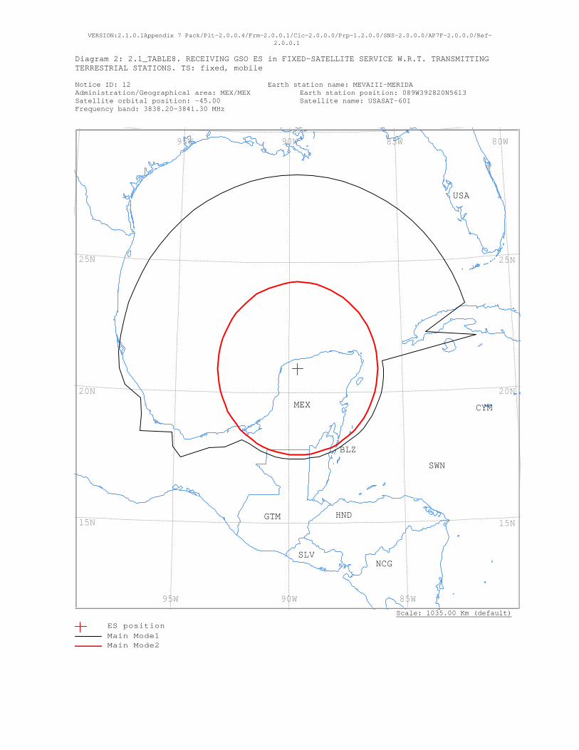
VERSION:2.1.0.1Appendix 7 Pack/Plt-2.0.0.4/Frm-2.0.0.1/Clc-2.0.0.0/Prp-1.2.0.0/SNS-2.0.0.0/AP7F-2.0.0.0/Ref-2.0.0.1
Diagram 2: 2.1_TABLE8. RECEIVING GSO ES in FIXED-SATELLITE SERVICE W.R.T. TRANSMITTING TERRESTRIAL STATIONS. TS: fixed, mobile Notice ID: 12 Earth station name: MEVAIII-MERIDA Administration/Geographical area: MEX/MEX Earth station position: 089W392820N5613 Satellite orbital position: -45.00 Satellite name: USASAT-60I Frequency band: 3838.20-3841.30 MHz
Scale: 1035.00 Km (default)
USA
SWN
SLVNCG
MEX
HNDGTM
CYM
BLZ
80W 85W 90W 95W
85W 90W 95W
25N
20N
15N
25N
20N
15N
ES positionMain Mode1 Main Mode2
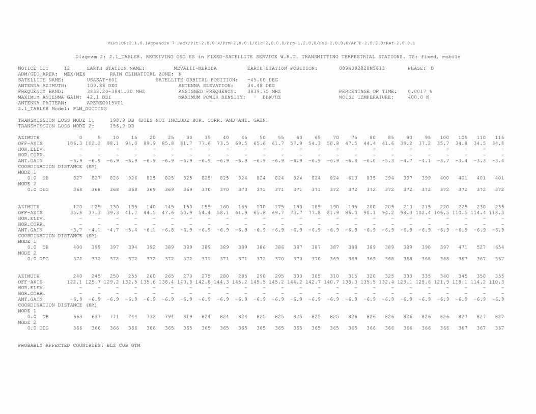
VERSION:2.1.0.1Appendix 7 Pack/Plt-2.0.0.4/Frm-2.0.0.1/Clc-2.0.0.0/Prp-1.2.0.0/SNS-2.0.0.0/AP7F-2.0.0.0/Ref-2.0.0.1
Diagram 2: 2.1_TABLE8. RECEIVING GSO ES in FIXED-SATELLITE SERVICE W.R.T. TRANSMITTING TERRESTRIAL STATIONS. TS: fixed, mobile
NOTICE ID: 12 EARTH STATION NAME: MEVAIII-MERIDA EARTH STATION POSITION: 089W392820N5613 PHASE: D ADM/GEO_AREA: MEX/MEX RAIN CLIMATICAL ZONE: N SATELLITE NAME: USASAT-60I SATELLITE ORBITAL POSITION: -45.00 DEG ANTENNA AZIMUTH: 109.88 DEG ANTENNA ELEVATION: 34.48 DEG FREQUENCY BAND: 3838.20-3841.30 MHZ ASSIGNED FREQUENCY: 3839.75 MHZ PERCENTAGE OF TIME: 0.0017 % MAXIMUM ANTENNA GAIN: 42.1 DBI MAXIMUM POWER DENSITY: - DBW/HZ NOISE TEMPERATURE: 400.0 K ANTENNA PATTERN: APEREC015V01 2.1_TABLE8 Model: PLM_DUCTING TRANSMISSION LOSS MODE 1: 198.9 DB (DOES NOT INCLUDE HOR. CORR. AND ANT. GAIN) TRANSMISSION LOSS MODE 2: 156.9 DB AZIMUTH 0 5 10 15 20 25 30 35 40 45 50 55 60 65 70 75 80 85 90 95 100 105 110 115 OFF-AXIS 106.3 102.2 98.1 94.0 89.9 85.8 81.7 77.6 73.5 69.5 65.6 61.7 57.9 54.3 50.8 47.5 44.4 41.6 39.2 37.2 35.7 34.8 34.5 34.8 HOR.ELEV. - - - - - - - - - - - - - - - - - - - - - - - - HOR.CORR. - - - - - - - - - - - - - - - - - - - - - - - - ANT.GAIN -6.9 -6.9 -6.9 -6.9 -6.9 -6.9 -6.9 -6.9 -6.9 -6.9 -6.9 -6.9 -6.9 -6.9 -6.9 -6.8 -6.0 -5.3 -4.7 -4.1 -3.7 -3.4 -3.3 -3.4 COORDINATION DISTANCE (KM) MODE 1 0.0 DB 827 827 826 826 825 825 825 825 825 824 824 824 824 824 824 613 835 394 397 399 400 401 401 401 MODE 2 0.0 DEG 368 368 368 368 369 369 369 370 370 370 371 371 371 371 372 372 372 372 372 372 372 372 372 372 AZIMUTH 120 125 130 135 140 145 150 155 160 165 170 175 180 185 190 195 200 205 210 215 220 225 230 235 OFF-AXIS 35.8 37.3 39.3 41.7 44.5 47.6 50.9 54.4 58.1 61.9 65.8 69.7 73.7 77.8 81.9 86.0 90.1 94.2 98.3 102.4 106.5 110.5 114.4 118.3 HOR.ELEV. - - - - - - - - - - - - - - - - - - - - - - - - HOR.CORR. - - - - - - - - - - - - - - - - - - - - - - - - ANT.GAIN -3.7 -4.1 -4.7 -5.4 -6.1 -6.8 -6.9 -6.9 -6.9 -6.9 -6.9 -6.9 -6.9 -6.9 -6.9 -6.9 -6.9 -6.9 -6.9 -6.9 -6.9 -6.9 -6.9 -6.9 COORDINATION DISTANCE (KM) MODE 1 0.0 DB 400 399 397 394 392 389 389 389 389 389 386 386 387 387 387 388 389 389 389 390 397 471 527 654 MODE 2 0.0 DEG 372 372 372 372 372 372 372 371 371 371 371 370 370 370 369 369 369 368 368 368 368 367 367 367 AZIMUTH 240 245 250 255 260 265 270 275 280 285 290 295 300 305 310 315 320 325 330 335 340 345 350 355 OFF-AXIS 122.1 125.7 129.2 132.5 135.6 138.4 140.8 142.8 144.3 145.2 145.5 145.2 144.2 142.7 140.7 138.3 135.5 132.4 129.1 125.6 121.9 118.1 114.2 110.3 HOR.ELEV. - - - - - - - - - - - - - - - - - - - - - - - - HOR.CORR. - - - - - - - - - - - - - - - - - - - - - - - - ANT.GAIN -6.9 -6.9 -6.9 -6.9 -6.9 -6.9 -6.9 -6.9 -6.9 -6.9 -6.9 -6.9 -6.9 -6.9 -6.9 -6.9 -6.9 -6.9 -6.9 -6.9 -6.9 -6.9 -6.9 -6.9 COORDINATION DISTANCE (KM) MODE 1 0.0 DB 663 637 771 744 732 794 819 824 824 824 825 825 825 825 825 826 826 826 826 826 826 827 827 827 MODE 2 0.0 DEG 366 366 366 366 366 365 365 365 365 365 365 365 365 365 365 365 366 366 366 366 366 367 367 367 PROBABLY AFFECTED COUNTRIES: BLZ CUB GTM
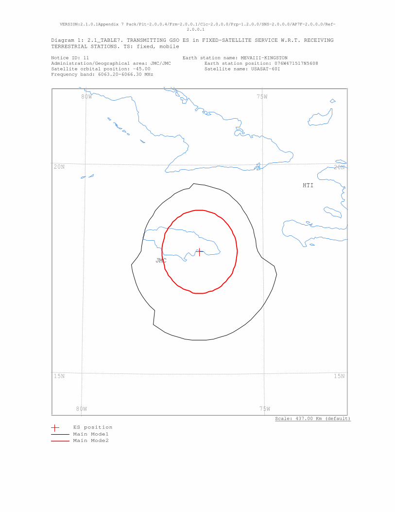
VERSION:2.1.0.1Appendix 7 Pack/Plt-2.0.0.4/Frm-2.0.0.1/Clc-2.0.0.0/Prp-1.2.0.0/SNS-2.0.0.0/AP7F-2.0.0.0/Ref-2.0.0.1
Diagram 1: 2.1_TABLE7. TRANSMITTING GSO ES in FIXED-SATELLITE SERVICE W.R.T. RECEIVING TERRESTRIAL STATIONS. TS: fixed, mobile Notice ID: 11 Earth station name: MEVAIII-KINGSTON Administration/Geographical area: JMC/JMC Earth station position: 076W471517N5608 Satellite orbital position: -45.00 Satellite name: USASAT-60I Frequency band: 6063.20-6066.30 MHz
Scale: 437.00 Km (default)
JMC
HTI
75W 80W
75W 80W
20N
15N
20N
15N
ES positionMain Mode1 Main Mode2

ANALYSIS DATE AND TIME: 2014-11-27 12:13:31
VERSION: 2.1.0.1Appendix 7 Pack/Plt-2.0.0.4/Frm-2.0.0.1/Clc-2.0.0.0/Prp-1.2.0.0/SNS-2.0.0.0/AP7F-2.0.0.0/Ref-2.0.0.1
Diagram 1: 2.1_TABLE7. TRANSMITTING GSO ES in FIXED-SATELLITE SERVICE W.R.T. RECEIVING TERRESTRIAL STATIONS. TS: fixed, mobile
NOTICE ID: 11 EARTH STATION NAME: MEVAIII-KINGSTON EARTH STATION POSITION: 076W471517N5608 PHASE: D ADM/GEO_AREA: JMC/JMC RAIN CLIMATICAL ZONE: N SATELLITE NAME: USASAT-60I SATELLITE ORBITAL POSITION: -45.00 DEG ANTENNA AZIMUTH: 116.42 DEG ANTENNA ELEVATION: 48.19 DEG FREQUENCY BAND: 6063.20-6066.30 MHZ ASSIGNED FREQUENCY: 6064.75 MHZ PERCENTAGE OF TIME: 0.0050 % MAXIMUM ANTENNA GAIN: 49.0 DBI MAXIMUM POWER DENSITY: -53.1 DBW/HZ NOISE TEMPERATURE: - K ANTENNA PATTERN: APEREC015V01 2.1_TABLE7 Model: PLM_DUCTING TRANSMISSION LOSS MODE 1: 159.9 DB (DOES NOT INCLUDE HOR. CORR. AND ANT. GAIN) TRANSMISSION LOSS MODE 2: 113.9 DB AZIMUTH 0 5 10 15 20 25 30 35 40 45 50 55 60 65 70 75 80 85 90 95 100 105 110 115 OFF-AXIS 107.3 104.1 100.9 97.6 94.3 90.9 87.6 84.3 81.0 77.7 74.5 71.4 68.4 65.4 62.6 60.0 57.6 55.3 53.3 51.6 50.2 49.2 48.5 48.2 HOR.ELEV. - - - - - - - - - - - - - - - - - - - - - - - - HOR.CORR. - - - - - - - - - - - - - - - - - - - - - - - - ANT.GAIN -10.0 -10.0 -10.0 -10.0 -10.0 -10.0 -10.0 -10.0 -10.0 -10.0 -10.0 -10.0 -10.0 -10.0 -10.0 -10.0 -10.0 -10.0 -10.0 -10.0 -10.0 -10.0 -10.0 -10.0 COORDINATION DISTANCE (KM) MODE 1 0.0 DB 178 177 176 175 176 176 175 174 173 172 170 170 169 169 169 169 169 169 173 184 225 236 237 237 MODE 2 0.0 DEG 110 110 110 110 110 110 110 110 111 111 111 111 111 111 112 112 112 112 112 112 112 112 112 112 AZIMUTH 120 125 130 135 140 145 150 155 160 165 170 175 180 185 190 195 200 205 210 215 220 225 230 235 OFF-AXIS 48.3 48.8 49.6 50.8 52.3 54.2 56.3 58.6 61.1 63.8 66.7 69.7 72.7 75.9 79.1 82.4 85.7 89.1 92.4 95.7 99.0 102.3 105.5 108.6 HOR.ELEV. - - - - - - - - - - - - - - - - - - - - - - - - HOR.CORR. - - - - - - - - - - - - - - - - - - - - - - - - ANT.GAIN -10.0 -10.0 -10.0 -10.0 -10.0 -10.0 -10.0 -10.0 -10.0 -10.0 -10.0 -10.0 -10.0 -10.0 -10.0 -10.0 -10.0 -10.0 -10.0 -10.0 -10.0 -10.0 -10.0 -10.0 COORDINATION DISTANCE (KM) MODE 1 0.0 DB 237 237 237 237 237 237 237 237 237 237 237 237 237 237 237 237 237 237 237 237 205 205 205 205 MODE 2 0.0 DEG 112 112 112 112 112 112 112 112 112 111 111 111 111 111 111 110 110 110 110 110 110 110 110 110 AZIMUTH 240 245 250 255 260 265 270 275 280 285 290 295 300 305 310 315 320 325 330 335 340 345 350 355 OFF-AXIS 111.6 114.6 117.4 120.0 122.4 124.7 126.7 128.4 129.8 130.8 131.5 131.8 131.7 131.2 130.4 129.2 127.7 125.8 123.7 121.4 118.9 116.2 113.3 110.3 HOR.ELEV. - - - - - - - - - - - - - - - - - - - - - - - - HOR.CORR. - - - - - - - - - - - - - - - - - - - - - - - - ANT.GAIN -10.0 -10.0 -10.0 -10.0 -10.0 -10.0 -10.0 -10.0 -10.0 -10.0 -10.0 -10.0 -10.0 -10.0 -10.0 -10.0 -10.0 -10.0 -10.0 -10.0 -10.0 -10.0 -10.0 -10.0 COORDINATION DISTANCE (KM) MODE 1 0.0 DB 205 204 204 204 203 183 171 170 169 169 169 169 169 168 168 168 168 168 168 169 170 172 171 181 MODE 2 0.0 DEG 110 110 110 110 110 110 110 110 110 110 110 110 110 110 110 110 110 110 110 110 110 110 110 110 PROBABLY AFFECTED COUNTRIES:
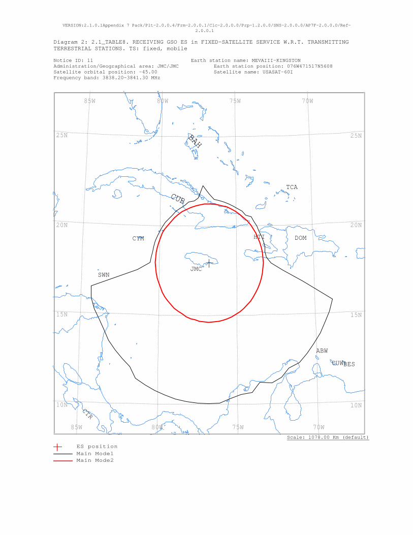
VERSION:2.1.0.1Appendix 7 Pack/Plt-2.0.0.4/Frm-2.0.0.1/Clc-2.0.0.0/Prp-1.2.0.0/SNS-2.0.0.0/AP7F-2.0.0.0/Ref-2.0.0.1
Diagram 2: 2.1_TABLE8. RECEIVING GSO ES in FIXED-SATELLITE SERVICE W.R.T. TRANSMITTING TERRESTRIAL STATIONS. TS: fixed, mobile Notice ID: 11 Earth station name: MEVAIII-KINGSTON Administration/Geographical area: JMC/JMC Earth station position: 076W471517N5608 Satellite orbital position: -45.00 Satellite name: USASAT-60I Frequency band: 3838.20-3841.30 MHz
Scale: 1078.00 Km (default)
TCA
SWNJMC
HTI DOMCYM
CUW
CUB
CTR
BES
BAH
ABW
70W 75W 80W 85W
70W 75W 80W 85W
25N
20N
15N
10N
25N
20N
15N
10N
ES positionMain Mode1 Main Mode2
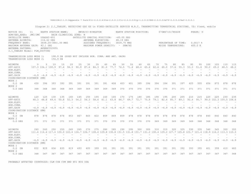
VERSION:2.1.0.1Appendix 7 Pack/Plt-2.0.0.4/Frm-2.0.0.1/Clc-2.0.0.0/Prp-1.2.0.0/SNS-2.0.0.0/AP7F-2.0.0.0/Ref-2.0.0.1
Diagram 2: 2.1_TABLE8. RECEIVING GSO ES in FIXED-SATELLITE SERVICE W.R.T. TRANSMITTING TERRESTRIAL STATIONS. TS: fixed, mobile
NOTICE ID: 11 EARTH STATION NAME: MEVAIII-KINGSTON EARTH STATION POSITION: 076W471517N5608 PHASE: D ADM/GEO_AREA: JMC/JMC RAIN CLIMATICAL ZONE: N SATELLITE NAME: USASAT-60I SATELLITE ORBITAL POSITION: -45.00 DEG ANTENNA AZIMUTH: 116.42 DEG ANTENNA ELEVATION: 48.19 DEG FREQUENCY BAND: 3838.20-3841.30 MHZ ASSIGNED FREQUENCY: 3839.75 MHZ PERCENTAGE OF TIME: 0.0017 % MAXIMUM ANTENNA GAIN: 42.1 DBI MAXIMUM POWER DENSITY: - DBW/HZ NOISE TEMPERATURE: 400.0 K ANTENNA PATTERN: APEREC015V01 2.1_TABLE8 Model: PLM_DUCTING TRANSMISSION LOSS MODE 1: 198.9 DB (DOES NOT INCLUDE HOR. CORR. AND ANT. GAIN) TRANSMISSION LOSS MODE 2: 156.9 DB AZIMUTH 0 5 10 15 20 25 30 35 40 45 50 55 60 65 70 75 80 85 90 95 100 105 110 115 OFF-AXIS 107.3 104.1 100.9 97.6 94.3 90.9 87.6 84.3 81.0 77.7 74.5 71.4 68.4 65.4 62.6 60.0 57.6 55.3 53.3 51.6 50.2 49.2 48.5 48.2 HOR.ELEV. - - - - - - - - - - - - - - - - - - - - - - - - HOR.CORR. - - - - - - - - - - - - - - - - - - - - - - - - ANT.GAIN -6.9 -6.9 -6.9 -6.9 -6.9 -6.9 -6.9 -6.9 -6.9 -6.9 -6.9 -6.9 -6.9 -6.9 -6.9 -6.9 -6.9 -6.9 -6.9 -6.9 -6.9 -6.9 -6.9 -6.9 COORDINATION DISTANCE (KM) MODE 1 0.0 DB 430 396 393 392 391 391 391 391 391 408 403 401 395 396 394 394 391 397 425 505 656 873 878 878 MODE 2 0.0 DEG 368 368 368 368 369 369 369 369 369 369 370 370 370 370 370 370 371 371 371 371 371 371 371 371 AZIMUTH 120 125 130 135 140 145 150 155 160 165 170 175 180 185 190 195 200 205 210 215 220 225 230 235 OFF-AXIS 48.3 48.8 49.6 50.8 52.3 54.2 56.3 58.6 61.1 63.8 66.7 69.7 72.7 75.9 79.1 82.4 85.7 89.1 92.4 95.7 99.0 102.3 105.5 108.6 HOR.ELEV. - - - - - - - - - - - - - - - - - - - - - - - - HOR.CORR. - - - - - - - - - - - - - - - - - - - - - - - - ANT.GAIN -6.9 -6.9 -6.9 -6.9 -6.9 -6.9 -6.9 -6.9 -6.9 -6.9 -6.9 -6.9 -6.9 -6.9 -6.9 -6.9 -6.9 -6.9 -6.9 -6.9 -6.9 -6.9 -6.9 -6.9 COORDINATION DISTANCE (KM) MODE 1 0.0 DB 878 878 878 878 853 867 865 822 859 849 859 878 878 878 878 878 878 878 878 878 840 840 840 840 MODE 2 0.0 DEG 371 371 371 371 371 371 371 371 370 370 370 370 370 370 369 369 369 369 369 368 368 368 368 368 AZIMUTH 240 245 250 255 260 265 270 275 280 285 290 295 300 305 310 315 320 325 330 335 340 345 350 355 OFF-AXIS 111.6 114.6 117.4 120.0 122.4 124.7 126.7 128.4 129.8 130.8 131.5 131.8 131.7 131.2 130.4 129.2 127.7 125.8 123.7 121.4 118.9 116.2 113.3 110.3 HOR.ELEV. - - - - - - - - - - - - - - - - - - - - - - - - HOR.CORR. - - - - - - - - - - - - - - - - - - - - - - - - ANT.GAIN -6.9 -6.9 -6.9 -6.9 -6.9 -6.9 -6.9 -6.9 -6.9 -6.9 -6.9 -6.9 -6.9 -6.9 -6.9 -6.9 -6.9 -6.9 -6.9 -6.9 -6.9 -6.9 -6.9 -6.9 COORDINATION DISTANCE (KM) MODE 1 0.0 DB 832 829 836 835 819 493 405 399 391 391 391 391 391 391 391 391 391 392 393 395 401 399 410 483 MODE 2 0.0 DEG 368 367 367 367 367 367 367 367 367 367 367 367 367 367 367 367 367 367 367 367 367 367 367 368 PROBABLY AFFECTED COUNTRIES: CLM CUB CYM HND HTI NCG USA

VERSION:2.1.0.1Appendix 7 Pack/Plt-2.0.0.4/Frm-2.0.0.1/Clc-2.0.0.0/Prp-1.2.0.0/SNS-2.0.0.0/AP7F-2.0.0.0/Ref-2.0.0.1
Diagram 1: 2.1_TABLE7. TRANSMITTING GSO ES in FIXED-SATELLITE SERVICE W.R.T. RECEIVING TERRESTRIAL STATIONS. TS: fixed, mobile Notice ID: 9 Earth station name: MEVAIII-HAVANA Administration/Geographical area: CUB/CUB Earth station position: 082W243322N5921 Satellite orbital position: -45.00 Satellite name: USASAT-60I Frequency band: 6063.20-6066.30 MHz
Scale: 399.00 Km (default)
CUB
80W 85W
80W 85W
25N
20N
25N
20N
ES positionMain Mode1 Main Mode2
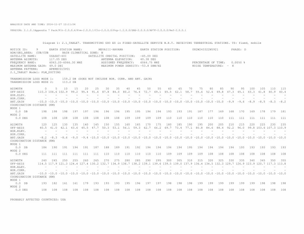
ANALYSIS DATE AND TIME: 2014-11-27 12:11:54
VERSION: 2.1.0.1Appendix 7 Pack/Plt-2.0.0.4/Frm-2.0.0.1/Clc-2.0.0.0/Prp-1.2.0.0/SNS-2.0.0.0/AP7F-2.0.0.0/Ref-2.0.0.1
Diagram 1: 2.1_TABLE7. TRANSMITTING GSO ES in FIXED-SATELLITE SERVICE W.R.T. RECEIVING TERRESTRIAL STATIONS. TS: fixed, mobile
NOTICE ID: 9 EARTH STATION NAME: MEVAIII-HAVANA EARTH STATION POSITION: 082W243322N5921 PHASE: D ADM/GEO_AREA: CUB/CUB RAIN CLIMATICAL ZONE: N SATELLITE NAME: USASAT-60I SATELLITE ORBITAL POSITION: -45.00 DEG ANTENNA AZIMUTH: 117.05 DEG ANTENNA ELEVATION: 40.38 DEG FREQUENCY BAND: 6063.20-6066.30 MHZ ASSIGNED FREQUENCY: 6064.75 MHZ PERCENTAGE OF TIME: 0.0050 % MAXIMUM ANTENNA GAIN: 49.0 DBI MAXIMUM POWER DENSITY: -53.8 DBW/HZ NOISE TEMPERATURE: - K ANTENNA PATTERN: APEREC015V01 2.1_TABLE7 Model: PLM_DUCTING TRANSMISSION LOSS MODE 1: 159.2 DB (DOES NOT INCLUDE HOR. CORR. AND ANT. GAIN) TRANSMISSION LOSS MODE 2: 113.2 DB AZIMUTH 0 5 10 15 20 25 30 35 40 45 50 55 60 65 70 75 80 85 90 95 100 105 110 115 OFF-AXIS 110.3 106.6 102.9 99.2 95.4 91.6 87.8 84.0 80.2 76.4 72.7 69.1 65.5 62.1 58.7 55.6 52.6 49.8 47.3 45.1 43.3 41.8 40.9 40.4 HOR.ELEV. - - - - - - - - - - - - - - - - - - - - - - - - HOR.CORR. - - - - - - - - - - - - - - - - - - - - - - - - ANT.GAIN -10.0 -10.0 -10.0 -10.0 -10.0 -10.0 -10.0 -10.0 -10.0 -10.0 -10.0 -10.0 -10.0 -10.0 -10.0 -10.0 -10.0 -10.0 -9.9 -9.4 -8.9 -8.5 -8.3 -8.2 COORDINATION DISTANCE (KM) MODE 1 0.0 DB 198 198 198 197 197 196 196 196 195 195 194 194 193 193 191 187 177 169 168 170 169 178 179 181 MODE 2 0.0 DEG 108 108 108 108 108 108 108 108 109 109 109 109 110 110 110 110 110 110 111 111 111 111 111 111 AZIMUTH 120 125 130 135 140 145 150 155 160 165 170 175 180 185 190 195 200 205 210 215 220 225 230 235 OFF-AXIS 40.5 41.0 42.1 43.6 45.5 47.7 50.3 53.1 56.1 59.3 62.7 66.2 69.7 73.4 77.1 80.8 84.6 88.4 92.2 96.0 99.8 103.6 107.3 110.9 HOR.ELEV. - - - - - - - - - - - - - - - - - - - - - - - - HOR.CORR. - - - - - - - - - - - - - - - - - - - - - - - - ANT.GAIN -8.2 -8.3 -8.6 -9.0 -9.4 -10.0 -10.0 -10.0 -10.0 -10.0 -10.0 -10.0 -10.0 -10.0 -10.0 -10.0 -10.0 -10.0 -10.0 -10.0 -10.0 -10.0 -10.0 -10.0 COORDINATION DISTANCE (KM) MODE 1 0.0 DB 184 190 191 194 191 187 188 189 191 192 194 194 194 194 195 194 194 194 194 193 193 193 193 193 MODE 2 0.0 DEG 111 111 111 111 111 111 110 110 110 110 110 110 109 109 109 109 108 108 108 108 108 108 108 108 AZIMUTH 240 245 250 255 260 265 270 275 280 285 290 295 300 305 310 315 320 325 330 335 340 345 350 355 OFF-AXIS 114.5 117.9 121.3 124.4 127.4 130.2 132.7 134.9 136.7 138.2 139.1 139.6 139.5 139.0 137.9 136.4 134.5 132.3 129.7 126.9 123.9 120.7 117.3 113.8 HOR.ELEV. - - - - - - - - - - - - - - - - - - - - - - - - HOR.CORR. - - - - - - - - - - - - - - - - - - - - - - - - ANT.GAIN -10.0 -10.0 -10.0 -10.0 -10.0 -10.0 -10.0 -10.0 -10.0 -10.0 -10.0 -10.0 -10.0 -10.0 -10.0 -10.0 -10.0 -10.0 -10.0 -10.0 -10.0 -10.0 -10.0 -10.0 COORDINATION DISTANCE (KM) MODE 1 0.0 DB 193 182 161 161 179 193 193 193 195 196 197 197 198 198 198 199 199 199 199 199 199 198 198 198 MODE 2 0.0 DEG 108 108 108 108 108 108 108 108 108 108 108 108 108 108 108 108 108 108 108 108 108 108 108 108 PROBABLY AFFECTED COUNTRIES: USA
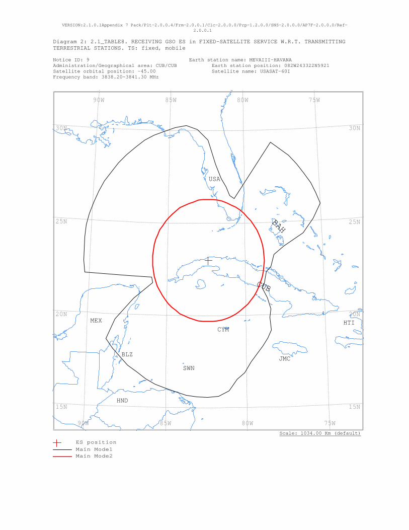
VERSION:2.1.0.1Appendix 7 Pack/Plt-2.0.0.4/Frm-2.0.0.1/Clc-2.0.0.0/Prp-1.2.0.0/SNS-2.0.0.0/AP7F-2.0.0.0/Ref-2.0.0.1
Diagram 2: 2.1_TABLE8. RECEIVING GSO ES in FIXED-SATELLITE SERVICE W.R.T. TRANSMITTING TERRESTRIAL STATIONS. TS: fixed, mobile Notice ID: 9 Earth station name: MEVAIII-HAVANA Administration/Geographical area: CUB/CUB Earth station position: 082W243322N5921 Satellite orbital position: -45.00 Satellite name: USASAT-60I Frequency band: 3838.20-3841.30 MHz
Scale: 1034.00 Km (default)
USA
SWN
MEX
JMC
HTI
HND
CYM
CUB
BLZ
BAH
75W 80W 85W 90W
75W 80W 85W 90W
30N
25N
20N
15N
30N
25N
20N
15N
ES positionMain Mode1 Main Mode2
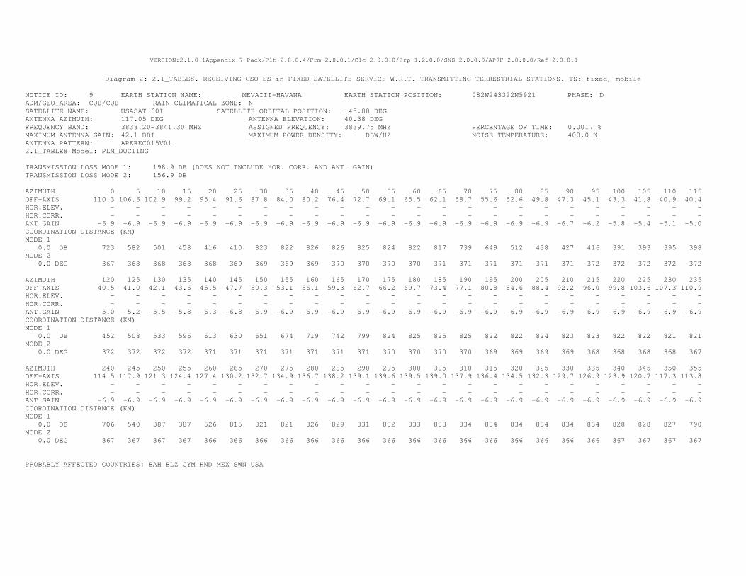
VERSION:2.1.0.1Appendix 7 Pack/Plt-2.0.0.4/Frm-2.0.0.1/Clc-2.0.0.0/Prp-1.2.0.0/SNS-2.0.0.0/AP7F-2.0.0.0/Ref-2.0.0.1
Diagram 2: 2.1_TABLE8. RECEIVING GSO ES in FIXED-SATELLITE SERVICE W.R.T. TRANSMITTING TERRESTRIAL STATIONS. TS: fixed, mobile
NOTICE ID: 9 EARTH STATION NAME: MEVAIII-HAVANA EARTH STATION POSITION: 082W243322N5921 PHASE: D ADM/GEO_AREA: CUB/CUB RAIN CLIMATICAL ZONE: N SATELLITE NAME: USASAT-60I SATELLITE ORBITAL POSITION: -45.00 DEG ANTENNA AZIMUTH: 117.05 DEG ANTENNA ELEVATION: 40.38 DEG FREQUENCY BAND: 3838.20-3841.30 MHZ ASSIGNED FREQUENCY: 3839.75 MHZ PERCENTAGE OF TIME: 0.0017 % MAXIMUM ANTENNA GAIN: 42.1 DBI MAXIMUM POWER DENSITY: - DBW/HZ NOISE TEMPERATURE: 400.0 K ANTENNA PATTERN: APEREC015V01 2.1_TABLE8 Model: PLM_DUCTING TRANSMISSION LOSS MODE 1: 198.9 DB (DOES NOT INCLUDE HOR. CORR. AND ANT. GAIN) TRANSMISSION LOSS MODE 2: 156.9 DB AZIMUTH 0 5 10 15 20 25 30 35 40 45 50 55 60 65 70 75 80 85 90 95 100 105 110 115 OFF-AXIS 110.3 106.6 102.9 99.2 95.4 91.6 87.8 84.0 80.2 76.4 72.7 69.1 65.5 62.1 58.7 55.6 52.6 49.8 47.3 45.1 43.3 41.8 40.9 40.4 HOR.ELEV. - - - - - - - - - - - - - - - - - - - - - - - - HOR.CORR. - - - - - - - - - - - - - - - - - - - - - - - - ANT.GAIN -6.9 -6.9 -6.9 -6.9 -6.9 -6.9 -6.9 -6.9 -6.9 -6.9 -6.9 -6.9 -6.9 -6.9 -6.9 -6.9 -6.9 -6.9 -6.7 -6.2 -5.8 -5.4 -5.1 -5.0 COORDINATION DISTANCE (KM) MODE 1 0.0 DB 723 582 501 458 416 410 823 822 826 826 825 824 822 817 739 649 512 438 427 416 391 393 395 398 MODE 2 0.0 DEG 367 368 368 368 368 369 369 369 369 370 370 370 370 371 371 371 371 371 371 372 372 372 372 372 AZIMUTH 120 125 130 135 140 145 150 155 160 165 170 175 180 185 190 195 200 205 210 215 220 225 230 235 OFF-AXIS 40.5 41.0 42.1 43.6 45.5 47.7 50.3 53.1 56.1 59.3 62.7 66.2 69.7 73.4 77.1 80.8 84.6 88.4 92.2 96.0 99.8 103.6 107.3 110.9 HOR.ELEV. - - - - - - - - - - - - - - - - - - - - - - - - HOR.CORR. - - - - - - - - - - - - - - - - - - - - - - - - ANT.GAIN -5.0 -5.2 -5.5 -5.8 -6.3 -6.8 -6.9 -6.9 -6.9 -6.9 -6.9 -6.9 -6.9 -6.9 -6.9 -6.9 -6.9 -6.9 -6.9 -6.9 -6.9 -6.9 -6.9 -6.9 COORDINATION DISTANCE (KM) MODE 1 0.0 DB 452 508 533 596 613 630 651 674 719 742 799 824 825 825 825 822 822 824 823 823 822 822 821 821 MODE 2 0.0 DEG 372 372 372 372 371 371 371 371 371 371 371 370 370 370 370 369 369 369 369 368 368 368 368 367 AZIMUTH 240 245 250 255 260 265 270 275 280 285 290 295 300 305 310 315 320 325 330 335 340 345 350 355 OFF-AXIS 114.5 117.9 121.3 124.4 127.4 130.2 132.7 134.9 136.7 138.2 139.1 139.6 139.5 139.0 137.9 136.4 134.5 132.3 129.7 126.9 123.9 120.7 117.3 113.8 HOR.ELEV. - - - - - - - - - - - - - - - - - - - - - - - - HOR.CORR. - - - - - - - - - - - - - - - - - - - - - - - - ANT.GAIN -6.9 -6.9 -6.9 -6.9 -6.9 -6.9 -6.9 -6.9 -6.9 -6.9 -6.9 -6.9 -6.9 -6.9 -6.9 -6.9 -6.9 -6.9 -6.9 -6.9 -6.9 -6.9 -6.9 -6.9 COORDINATION DISTANCE (KM) MODE 1 0.0 DB 706 540 387 387 526 815 821 821 826 829 831 832 833 833 834 834 834 834 834 834 828 828 827 790 MODE 2 0.0 DEG 367 367 367 367 366 366 366 366 366 366 366 366 366 366 366 366 366 366 366 366 367 367 367 367 PROBABLY AFFECTED COUNTRIES: BAH BLZ CYM HND MEX SWN USA

VERSION:2.1.0.1Appendix 7 Pack/Plt-2.0.0.4/Frm-2.0.0.1/Clc-2.0.0.0/Prp-1.2.0.0/SNS-2.0.0.0/AP7F-2.0.0.0/Ref-2.0.0.1
Diagram 1: 2.1_TABLE7. TRANSMITTING GSO ES in FIXED-SATELLITE SERVICE W.R.T. RECEIVING TERRESTRIAL STATIONS. TS: fixed, mobile Notice ID: 8 Earth station name: MEVAIII-GEORGETOWN Administration/Geographical area: CYM/CYM Earth station position: 081W212819N1734 Satellite orbital position: -45.00 Satellite name: USASAT-60I Frequency band: 6063.20-6066.30 MHz
Scale: 439.00 Km (default)
SWN
JMC
CYM
CUB
80W 85W
80W 85W
20N20N
ES positionMain Mode1 Main Mode2

ANALYSIS DATE AND TIME: 2014-11-27 12:11:17
VERSION: 2.1.0.1Appendix 7 Pack/Plt-2.0.0.4/Frm-2.0.0.1/Clc-2.0.0.0/Prp-1.2.0.0/SNS-2.0.0.0/AP7F-2.0.0.0/Ref-2.0.0.1
Diagram 1: 2.1_TABLE7. TRANSMITTING GSO ES in FIXED-SATELLITE SERVICE W.R.T. RECEIVING TERRESTRIAL STATIONS. TS: fixed, mobile
NOTICE ID: 8 EARTH STATION NAME: MEVAIII-GEORGETOWN EARTH STATION POSITION: 081W212819N1734 PHASE: D ADM/GEO_AREA: CYM/CYM RAIN CLIMATICAL ZONE: N SATELLITE NAME: USASAT-60I SATELLITE ORBITAL POSITION: -45.00 DEG ANTENNA AZIMUTH: 114.17 DEG ANTENNA ELEVATION: 43.15 DEG FREQUENCY BAND: 6063.20-6066.30 MHZ ASSIGNED FREQUENCY: 6064.75 MHZ PERCENTAGE OF TIME: 0.0050 % MAXIMUM ANTENNA GAIN: 49.0 DBI MAXIMUM POWER DENSITY: -52.9 DBW/HZ NOISE TEMPERATURE: - K ANTENNA PATTERN: APEREC015V01 2.1_TABLE7 Model: PLM_DUCTING TRANSMISSION LOSS MODE 1: 160.1 DB (DOES NOT INCLUDE HOR. CORR. AND ANT. GAIN) TRANSMISSION LOSS MODE 2: 114.1 DB AZIMUTH 0 5 10 15 20 25 30 35 40 45 50 55 60 65 70 75 80 85 90 95 100 105 110 115 OFF-AXIS 107.4 103.9 100.3 96.7 93.0 89.4 85.8 82.1 78.5 75.0 71.5 68.0 64.7 61.5 58.4 55.6 52.9 50.4 48.3 46.4 45.0 43.9 43.3 43.2 HOR.ELEV. - - - - - - - - - - - - - - - - - - - - - - - - HOR.CORR. - - - - - - - - - - - - - - - - - - - - - - - - ANT.GAIN -10.0 -10.0 -10.0 -10.0 -10.0 -10.0 -10.0 -10.0 -10.0 -10.0 -10.0 -10.0 -10.0 -10.0 -10.0 -10.0 -10.0 -10.0 -10.0 -9.7 -9.3 -9.1 -8.9 -8.9 COORDINATION DISTANCE (KM) MODE 1 0.0 DB 222 222 228 228 228 228 228 228 228 228 228 222 217 209 209 207 207 207 210 214 218 221 226 229 MODE 2 0.0 DEG 110 110 110 110 110 110 110 110 111 111 111 111 112 112 112 112 112 112 112 113 113 113 113 113 AZIMUTH 120 125 130 135 140 145 150 155 160 165 170 175 180 185 190 195 200 205 210 215 220 225 230 235 OFF-AXIS 43.5 44.2 45.4 47.0 48.9 51.2 53.7 56.5 59.4 62.6 65.8 69.2 72.6 76.1 79.7 83.3 87.0 90.6 94.2 97.9 101.5 105.0 108.5 112.0 HOR.ELEV. - - - - - - - - - - - - - - - - - - - - - - - - HOR.CORR. - - - - - - - - - - - - - - - - - - - - - - - - ANT.GAIN -9.0 -9.1 -9.4 -9.8 -10.0 -10.0 -10.0 -10.0 -10.0 -10.0 -10.0 -10.0 -10.0 -10.0 -10.0 -10.0 -10.0 -10.0 -10.0 -10.0 -10.0 -10.0 -10.0 -10.0 COORDINATION DISTANCE (KM) MODE 1 0.0 DB 230 232 229 230 228 228 228 239 239 239 239 239 239 239 239 239 239 239 239 239 239 239 239 239 MODE 2 0.0 DEG 113 113 113 112 112 112 112 112 112 112 111 111 111 111 111 110 110 110 110 110 110 110 110 110 AZIMUTH 240 245 250 255 260 265 270 275 280 285 290 295 300 305 310 315 320 325 330 335 340 345 350 355 OFF-AXIS 115.3 118.5 121.6 124.4 127.1 129.6 131.7 133.6 135.0 136.1 136.7 136.8 136.5 135.8 134.6 133.0 131.1 128.8 126.3 123.5 120.6 117.4 114.2 110.8 HOR.ELEV. - - - - - - - - - - - - - - - - - - - - - - - - HOR.CORR. - - - - - - - - - - - - - - - - - - - - - - - - ANT.GAIN -10.0 -10.0 -10.0 -10.0 -10.0 -10.0 -10.0 -10.0 -10.0 -10.0 -10.0 -10.0 -10.0 -10.0 -10.0 -10.0 -10.0 -10.0 -10.0 -10.0 -10.0 -10.0 -10.0 -10.0 COORDINATION DISTANCE (KM) MODE 1 0.0 DB 239 239 239 239 239 239 239 239 239 239 228 228 228 222 219 215 214 212 214 215 217 219 222 222 MODE 2 0.0 DEG 110 110 110 110 110 110 110 110 110 110 110 110 110 110 110 110 110 110 110 110 110 110 110 110 PROBABLY AFFECTED COUNTRIES:
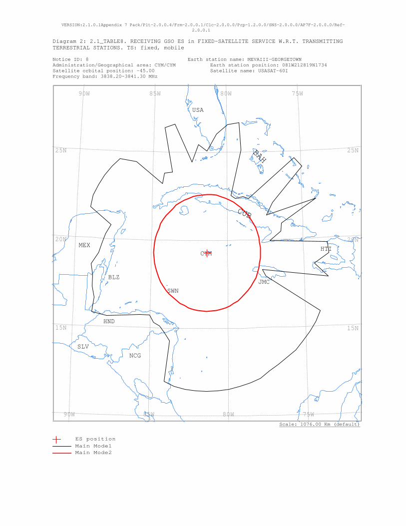
VERSION:2.1.0.1Appendix 7 Pack/Plt-2.0.0.4/Frm-2.0.0.1/Clc-2.0.0.0/Prp-1.2.0.0/SNS-2.0.0.0/AP7F-2.0.0.0/Ref-2.0.0.1
Diagram 2: 2.1_TABLE8. RECEIVING GSO ES in FIXED-SATELLITE SERVICE W.R.T. TRANSMITTING TERRESTRIAL STATIONS. TS: fixed, mobile Notice ID: 8 Earth station name: MEVAIII-GEORGETOWN Administration/Geographical area: CYM/CYM Earth station position: 081W212819N1734 Satellite orbital position: -45.00 Satellite name: USASAT-60I Frequency band: 3838.20-3841.30 MHz
Scale: 1076.00 Km (default)
USA
SWN
SLVNCG
MEX
JMC
HTI
HND
CYM
CUB
BLZ
BAH
75W 80W 85W 90W
75W 80W 85W 90W
25N
20N
15N
25N
20N
15N
ES positionMain Mode1 Main Mode2
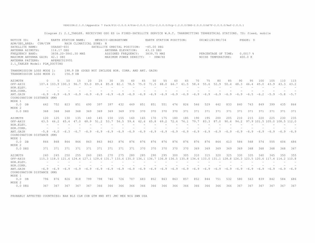
VERSION:2.1.0.1Appendix 7 Pack/Plt-2.0.0.4/Frm-2.0.0.1/Clc-2.0.0.0/Prp-1.2.0.0/SNS-2.0.0.0/AP7F-2.0.0.0/Ref-2.0.0.1
Diagram 2: 2.1_TABLE8. RECEIVING GSO ES in FIXED-SATELLITE SERVICE W.R.T. TRANSMITTING TERRESTRIAL STATIONS. TS: fixed, mobile
NOTICE ID: 8 EARTH STATION NAME: MEVAIII-GEORGETOWN EARTH STATION POSITION: 081W212819N1734 PHASE: D ADM/GEO_AREA: CYM/CYM RAIN CLIMATICAL ZONE: N SATELLITE NAME: USASAT-60I SATELLITE ORBITAL POSITION: -45.00 DEG ANTENNA AZIMUTH: 114.17 DEG ANTENNA ELEVATION: 43.15 DEG FREQUENCY BAND: 3838.20-3841.30 MHZ ASSIGNED FREQUENCY: 3839.75 MHZ PERCENTAGE OF TIME: 0.0017 % MAXIMUM ANTENNA GAIN: 42.1 DBI MAXIMUM POWER DENSITY: - DBW/HZ NOISE TEMPERATURE: 400.0 K ANTENNA PATTERN: APEREC015V01 2.1_TABLE8 Model: PLM_DUCTING TRANSMISSION LOSS MODE 1: 198.9 DB (DOES NOT INCLUDE HOR. CORR. AND ANT. GAIN) TRANSMISSION LOSS MODE 2: 156.9 DB AZIMUTH 0 5 10 15 20 25 30 35 40 45 50 55 60 65 70 75 80 85 90 95 100 105 110 115 OFF-AXIS 107.4 103.9 100.3 96.7 93.0 89.4 85.8 82.1 78.5 75.0 71.5 68.0 64.7 61.5 58.4 55.6 52.9 50.4 48.3 46.4 45.0 43.9 43.3 43.2 HOR.ELEV. - - - - - - - - - - - - - - - - - - - - - - - - HOR.CORR. - - - - - - - - - - - - - - - - - - - - - - - - ANT.GAIN -6.9 -6.9 -6.9 -6.9 -6.9 -6.9 -6.9 -6.9 -6.9 -6.9 -6.9 -6.9 -6.9 -6.9 -6.9 -6.9 -6.9 -6.9 -6.9 -6.5 -6.2 -5.9 -5.8 -5.7 COORDINATION DISTANCE (KM) MODE 1 0.0 DB 642 752 823 851 690 397 397 432 449 851 851 551 476 826 546 529 442 833 840 743 849 399 435 864 MODE 2 0.0 DEG 368 368 368 368 369 369 369 369 370 370 370 370 370 371 371 371 371 371 371 371 371 371 371 371 AZIMUTH 120 125 130 135 140 145 150 155 160 165 170 175 180 185 190 195 200 205 210 215 220 225 230 235 OFF-AXIS 43.5 44.2 45.4 47.0 48.9 51.2 53.7 56.5 59.4 62.6 65.8 69.2 72.6 76.1 79.7 83.3 87.0 90.6 94.2 97.9 101.5 105.0 108.5 112.0 HOR.ELEV. - - - - - - - - - - - - - - - - - - - - - - - - HOR.CORR. - - - - - - - - - - - - - - - - - - - - - - - - ANT.GAIN -5.8 -6.0 -6.3 -6.7 -6.9 -6.9 -6.9 -6.9 -6.9 -6.9 -6.9 -6.9 -6.9 -6.9 -6.9 -6.9 -6.9 -6.9 -6.9 -6.9 -6.9 -6.9 -6.9 -6.9 COORDINATION DISTANCE (KM) MODE 1 0.0 DB 866 868 864 866 863 863 863 876 876 876 876 876 876 876 876 876 864 613 584 568 574 555 606 686 MODE 2 0.0 DEG 371 371 371 371 371 371 371 371 371 370 370 370 370 370 369 369 369 369 369 368 368 368 368 367 AZIMUTH 240 245 250 255 260 265 270 275 280 285 290 295 300 305 310 315 320 325 330 335 340 345 350 355 OFF-AXIS 115.3 118.5 121.6 124.4 127.1 129.6 131.7 133.6 135.0 136.1 136.7 136.8 136.5 135.8 134.6 133.0 131.1 128.8 126.3 123.5 120.6 117.4 114.2 110.8 HOR.ELEV. - - - - - - - - - - - - - - - - - - - - - - - - HOR.CORR. - - - - - - - - - - - - - - - - - - - - - - - - ANT.GAIN -6.9 -6.9 -6.9 -6.9 -6.9 -6.9 -6.9 -6.9 -6.9 -6.9 -6.9 -6.9 -6.9 -6.9 -6.9 -6.9 -6.9 -6.9 -6.9 -6.9 -6.9 -6.9 -6.9 -6.9 COORDINATION DISTANCE (KM) MODE 1 0.0 DB 796 876 826 818 799 798 746 726 707 683 852 863 863 857 852 844 751 532 580 563 839 842 584 686 MODE 2 0.0 DEG 367 367 367 367 367 366 366 366 366 366 366 366 366 366 366 366 366 366 367 367 367 367 367 367 PROBABLY AFFECTED COUNTRIES: BAH BLZ CLM CUB GTM HND HTI JMC MEX NCG SWN USA
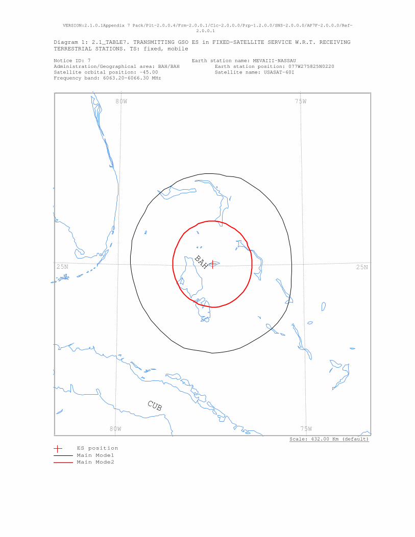
VERSION:2.1.0.1Appendix 7 Pack/Plt-2.0.0.4/Frm-2.0.0.1/Clc-2.0.0.0/Prp-1.2.0.0/SNS-2.0.0.0/AP7F-2.0.0.0/Ref-2.0.0.1
Diagram 1: 2.1_TABLE7. TRANSMITTING GSO ES in FIXED-SATELLITE SERVICE W.R.T. RECEIVING TERRESTRIAL STATIONS. TS: fixed, mobile Notice ID: 7 Earth station name: MEVAIII-NASSAU Administration/Geographical area: BAH/BAH Earth station position: 077W275825N0220 Satellite orbital position: -45.00 Satellite name: USASAT-60I Frequency band: 6063.20-6066.30 MHz
Scale: 432.00 Km (default)
CUB
BAH
75W 80W
75W 80W
25N25N
ES positionMain Mode1 Main Mode2

ANALYSIS DATE AND TIME: 2014-11-27 12:10:43
VERSION: 2.1.0.1Appendix 7 Pack/Plt-2.0.0.4/Frm-2.0.0.1/Clc-2.0.0.0/Prp-1.2.0.0/SNS-2.0.0.0/AP7F-2.0.0.0/Ref-2.0.0.1
Diagram 1: 2.1_TABLE7. TRANSMITTING GSO ES in FIXED-SATELLITE SERVICE W.R.T. RECEIVING TERRESTRIAL STATIONS. TS: fixed, mobile
NOTICE ID: 7 EARTH STATION NAME: MEVAIII-NASSAU EARTH STATION POSITION: 077W275825N0220 PHASE: D ADM/GEO_AREA: BAH/BAH RAIN CLIMATICAL ZONE: N SATELLITE NAME: USASAT-60I SATELLITE ORBITAL POSITION: -45.00 DEG ANTENNA AZIMUTH: 123.63 DEG ANTENNA ELEVATION: 43.57 DEG FREQUENCY BAND: 6063.20-6066.30 MHZ ASSIGNED FREQUENCY: 6064.75 MHZ PERCENTAGE OF TIME: 0.0050 % MAXIMUM ANTENNA GAIN: 49.0 DBI MAXIMUM POWER DENSITY: -51.9 DBW/HZ NOISE TEMPERATURE: - K ANTENNA PATTERN: APEREC015V01 2.1_TABLE7 Model: PLM_DUCTING TRANSMISSION LOSS MODE 1: 161.1 DB (DOES NOT INCLUDE HOR. CORR. AND ANT. GAIN) TRANSMISSION LOSS MODE 2: 115.1 DB AZIMUTH 0 5 10 15 20 25 30 35 40 45 50 55 60 65 70 75 80 85 90 95 100 105 110 115 OFF-AXIS 113.7 110.3 106.9 103.4 99.8 96.2 92.6 89.0 85.4 81.8 78.2 74.7 71.2 67.8 64.6 61.4 58.4 55.5 52.9 50.5 48.4 46.6 45.2 44.3 HOR.ELEV. - - - - - - - - - - - - - - - - - - - - - - - - HOR.CORR. - - - - - - - - - - - - - - - - - - - - - - - - ANT.GAIN -10.0 -10.0 -10.0 -10.0 -10.0 -10.0 -10.0 -10.0 -10.0 -10.0 -10.0 -10.0 -10.0 -10.0 -10.0 -10.0 -10.0 -10.0 -10.0 -10.0 -10.0 -9.7 -9.4 -9.1 COORDINATION DISTANCE (KM) MODE 1 0.0 DB 227 227 224 226 228 225 225 225 225 224 224 222 221 220 218 217 217 216 216 217 218 222 226 230 MODE 2 0.0 DEG 107 107 107 107 107 107 107 107 107 107 108 108 108 108 108 109 109 109 109 109 109 109 109 110 AZIMUTH 120 125 130 135 140 145 150 155 160 165 170 175 180 185 190 195 200 205 210 215 220 225 230 235 OFF-AXIS 43.7 43.6 43.9 44.7 46.0 47.6 49.5 51.8 54.3 57.1 60.0 63.1 66.3 69.7 73.1 76.6 80.2 83.8 87.4 91.0 94.6 98.2 101.8 105.3 HOR.ELEV. - - - - - - - - - - - - - - - - - - - - - - - - HOR.CORR. - - - - - - - - - - - - - - - - - - - - - - - - ANT.GAIN -9.0 -9.0 -9.1 -9.3 -9.6 -9.9 -10.0 -10.0 -10.0 -10.0 -10.0 -10.0 -10.0 -10.0 -10.0 -10.0 -10.0 -10.0 -10.0 -10.0 -10.0 -10.0 -10.0 -10.0 COORDINATION DISTANCE (KM) MODE 1 0.0 DB 232 232 232 229 227 224 224 224 224 224 224 224 224 221 221 222 224 223 221 219 219 219 218 218 MODE 2 0.0 DEG 110 110 110 109 109 109 109 109 109 109 109 109 108 108 108 108 108 107 107 107 107 107 107 107 AZIMUTH 240 245 250 255 260 265 270 275 280 285 290 295 300 305 310 315 320 325 330 335 340 345 350 355 OFF-AXIS 108.8 112.2 115.4 118.6 121.6 124.5 127.1 129.5 131.6 133.4 134.8 135.7 136.3 136.4 136.1 135.3 134.0 132.4 130.5 128.2 125.7 122.9 120.0 116.9 HOR.ELEV. - - - - - - - - - - - - - - - - - - - - - - - - HOR.CORR. - - - - - - - - - - - - - - - - - - - - - - - - ANT.GAIN -10.0 -10.0 -10.0 -10.0 -10.0 -10.0 -10.0 -10.0 -10.0 -10.0 -10.0 -10.0 -10.0 -10.0 -10.0 -10.0 -10.0 -10.0 -10.0 -10.0 -10.0 -10.0 -10.0 -10.0 COORDINATION DISTANCE (KM) MODE 1 0.0 DB 218 218 217 217 218 220 221 222 222 225 225 225 225 225 228 228 228 227 225 227 227 227 228 228 MODE 2 0.0 DEG 107 107 107 107 107 107 107 107 107 107 107 107 107 107 107 107 107 107 107 107 107 107 107 107 PROBABLY AFFECTED COUNTRIES:
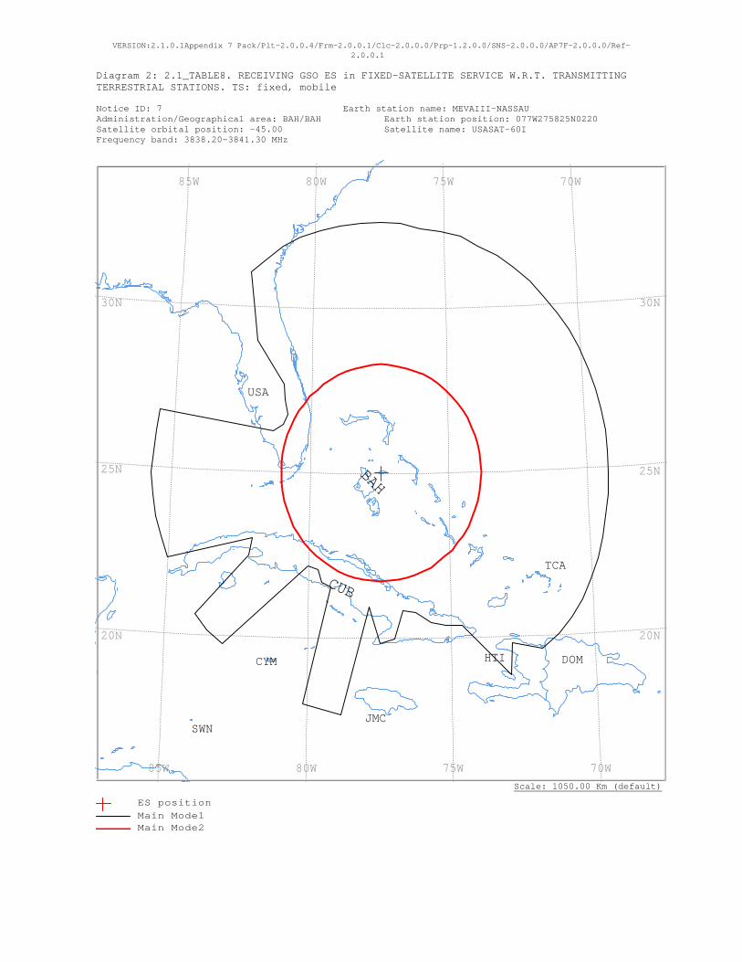
VERSION:2.1.0.1Appendix 7 Pack/Plt-2.0.0.4/Frm-2.0.0.1/Clc-2.0.0.0/Prp-1.2.0.0/SNS-2.0.0.0/AP7F-2.0.0.0/Ref-2.0.0.1
Diagram 2: 2.1_TABLE8. RECEIVING GSO ES in FIXED-SATELLITE SERVICE W.R.T. TRANSMITTING TERRESTRIAL STATIONS. TS: fixed, mobile Notice ID: 7 Earth station name: MEVAIII-NASSAU Administration/Geographical area: BAH/BAH Earth station position: 077W275825N0220 Satellite orbital position: -45.00 Satellite name: USASAT-60I Frequency band: 3838.20-3841.30 MHz
Scale: 1050.00 Km (default)
USA
TCA
SWNJMC
HTI DOMCYM
CUB
BAH
70W 75W 80W 85W
70W 75W 80W 85W
30N
25N
20N
30N
25N
20N
ES positionMain Mode1 Main Mode2
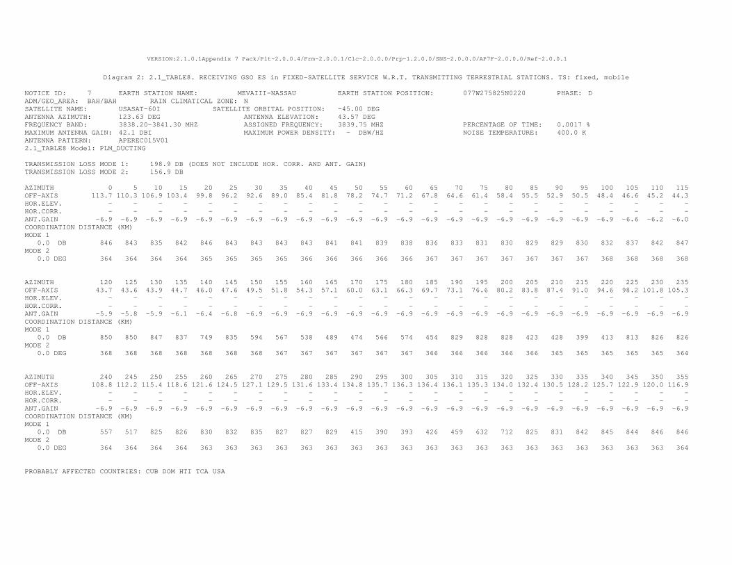
VERSION:2.1.0.1Appendix 7 Pack/Plt-2.0.0.4/Frm-2.0.0.1/Clc-2.0.0.0/Prp-1.2.0.0/SNS-2.0.0.0/AP7F-2.0.0.0/Ref-2.0.0.1
Diagram 2: 2.1_TABLE8. RECEIVING GSO ES in FIXED-SATELLITE SERVICE W.R.T. TRANSMITTING TERRESTRIAL STATIONS. TS: fixed, mobile
NOTICE ID: 7 EARTH STATION NAME: MEVAIII-NASSAU EARTH STATION POSITION: 077W275825N0220 PHASE: D ADM/GEO_AREA: BAH/BAH RAIN CLIMATICAL ZONE: N SATELLITE NAME: USASAT-60I SATELLITE ORBITAL POSITION: -45.00 DEG ANTENNA AZIMUTH: 123.63 DEG ANTENNA ELEVATION: 43.57 DEG FREQUENCY BAND: 3838.20-3841.30 MHZ ASSIGNED FREQUENCY: 3839.75 MHZ PERCENTAGE OF TIME: 0.0017 % MAXIMUM ANTENNA GAIN: 42.1 DBI MAXIMUM POWER DENSITY: - DBW/HZ NOISE TEMPERATURE: 400.0 K ANTENNA PATTERN: APEREC015V01 2.1_TABLE8 Model: PLM_DUCTING TRANSMISSION LOSS MODE 1: 198.9 DB (DOES NOT INCLUDE HOR. CORR. AND ANT. GAIN) TRANSMISSION LOSS MODE 2: 156.9 DB AZIMUTH 0 5 10 15 20 25 30 35 40 45 50 55 60 65 70 75 80 85 90 95 100 105 110 115 OFF-AXIS 113.7 110.3 106.9 103.4 99.8 96.2 92.6 89.0 85.4 81.8 78.2 74.7 71.2 67.8 64.6 61.4 58.4 55.5 52.9 50.5 48.4 46.6 45.2 44.3 HOR.ELEV. - - - - - - - - - - - - - - - - - - - - - - - - HOR.CORR. - - - - - - - - - - - - - - - - - - - - - - - - ANT.GAIN -6.9 -6.9 -6.9 -6.9 -6.9 -6.9 -6.9 -6.9 -6.9 -6.9 -6.9 -6.9 -6.9 -6.9 -6.9 -6.9 -6.9 -6.9 -6.9 -6.9 -6.9 -6.6 -6.2 -6.0 COORDINATION DISTANCE (KM) MODE 1 0.0 DB 846 843 835 842 846 843 843 843 843 841 841 839 838 836 833 831 830 829 829 830 832 837 842 847 MODE 2 0.0 DEG 364 364 364 364 365 365 365 365 366 366 366 366 366 367 367 367 367 367 367 367 368 368 368 368 AZIMUTH 120 125 130 135 140 145 150 155 160 165 170 175 180 185 190 195 200 205 210 215 220 225 230 235 OFF-AXIS 43.7 43.6 43.9 44.7 46.0 47.6 49.5 51.8 54.3 57.1 60.0 63.1 66.3 69.7 73.1 76.6 80.2 83.8 87.4 91.0 94.6 98.2 101.8 105.3 HOR.ELEV. - - - - - - - - - - - - - - - - - - - - - - - - HOR.CORR. - - - - - - - - - - - - - - - - - - - - - - - - ANT.GAIN -5.9 -5.8 -5.9 -6.1 -6.4 -6.8 -6.9 -6.9 -6.9 -6.9 -6.9 -6.9 -6.9 -6.9 -6.9 -6.9 -6.9 -6.9 -6.9 -6.9 -6.9 -6.9 -6.9 -6.9 COORDINATION DISTANCE (KM) MODE 1 0.0 DB 850 850 847 837 749 835 594 567 538 489 474 566 574 454 829 828 828 423 428 399 413 813 826 826 MODE 2 0.0 DEG 368 368 368 368 368 368 368 367 367 367 367 367 367 366 366 366 366 366 365 365 365 365 365 364 AZIMUTH 240 245 250 255 260 265 270 275 280 285 290 295 300 305 310 315 320 325 330 335 340 345 350 355 OFF-AXIS 108.8 112.2 115.4 118.6 121.6 124.5 127.1 129.5 131.6 133.4 134.8 135.7 136.3 136.4 136.1 135.3 134.0 132.4 130.5 128.2 125.7 122.9 120.0 116.9 HOR.ELEV. - - - - - - - - - - - - - - - - - - - - - - - - HOR.CORR. - - - - - - - - - - - - - - - - - - - - - - - - ANT.GAIN -6.9 -6.9 -6.9 -6.9 -6.9 -6.9 -6.9 -6.9 -6.9 -6.9 -6.9 -6.9 -6.9 -6.9 -6.9 -6.9 -6.9 -6.9 -6.9 -6.9 -6.9 -6.9 -6.9 -6.9 COORDINATION DISTANCE (KM) MODE 1 0.0 DB 557 517 825 826 830 832 835 827 827 829 415 390 393 426 459 632 712 825 831 842 845 844 846 846 MODE 2 0.0 DEG 364 364 364 364 363 363 363 363 363 363 363 363 363 363 363 363 363 363 363 363 363 363 363 364 PROBABLY AFFECTED COUNTRIES: CUB DOM HTI TCA USA
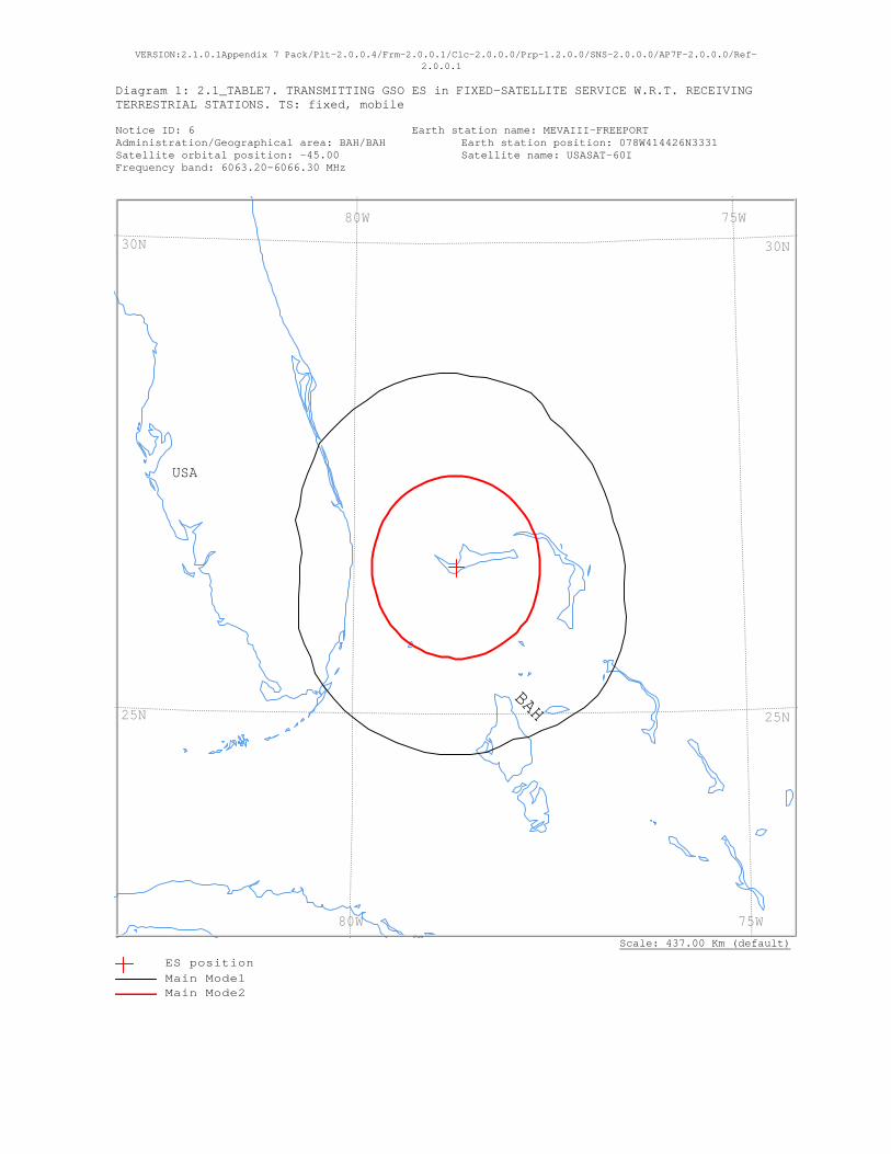
VERSION:2.1.0.1Appendix 7 Pack/Plt-2.0.0.4/Frm-2.0.0.1/Clc-2.0.0.0/Prp-1.2.0.0/SNS-2.0.0.0/AP7F-2.0.0.0/Ref-2.0.0.1
Diagram 1: 2.1_TABLE7. TRANSMITTING GSO ES in FIXED-SATELLITE SERVICE W.R.T. RECEIVING TERRESTRIAL STATIONS. TS: fixed, mobile Notice ID: 6 Earth station name: MEVAIII-FREEPORT Administration/Geographical area: BAH/BAH Earth station position: 078W414426N3331 Satellite orbital position: -45.00 Satellite name: USASAT-60I Frequency band: 6063.20-6066.30 MHz
Scale: 437.00 Km (default)
USA
BAH
75W 80W
75W 80W
30N
25N
30N
25N
ES positionMain Mode1 Main Mode2

VERSION:2.1.0.1Appendix 7 Pack/Plt-2.0.0.4/Frm-2.0.0.1/Clc-2.0.0.0/Prp-1.2.0.0/SNS-2.0.0.0/AP7F-2.0.0.0/Ref-2.0.0.1
Diagram 1: 2.1_TABLE7. TRANSMITTING GSO ES in FIXED-SATELLITE SERVICE W.R.T. RECEIVING TERRESTRIAL STATIONS. TS: fixed, mobile
NOTICE ID: 6 EARTH STATION NAME: MEVAIII-FREEPORT EARTH STATION POSITION: 078W414426N3331 PHASE: D ADM/GEO_AREA: BAH/BAH RAIN CLIMATICAL ZONE: N SATELLITE NAME: USASAT-60I SATELLITE ORBITAL POSITION: -45.00 DEG ANTENNA AZIMUTH: 123.84 DEG ANTENNA ELEVATION: 41.61 DEG FREQUENCY BAND: 6063.20-6066.30 MHZ ASSIGNED FREQUENCY: 6064.75 MHZ PERCENTAGE OF TIME: 0.0050 % MAXIMUM ANTENNA GAIN: 49.0 DBI MAXIMUM POWER DENSITY: -51.9 DBW/HZ NOISE TEMPERATURE: - K ANTENNA PATTERN: APEREC015V01 2.1_TABLE7 Model: PLM_DUCTING TRANSMISSION LOSS MODE 1: 161.1 DB (DOES NOT INCLUDE HOR. CORR. AND ANT. GAIN) TRANSMISSION LOSS MODE 2: 115.1 DB AZIMUTH 0 5 10 15 20 25 30 35 40 45 50 55 60 65 70 75 80 85 90 95 100 105 110 115 OFF-AXIS 114.6 111.1 107.6 104.0 100.3 96.6 92.9 89.1 85.4 81.7 78.0 74.3 70.8 67.2 63.8 60.5 57.4 54.4 51.6 49.1 46.8 45.0 43.4 42.4 HOR.ELEV. - - - - - - - - - - - - - - - - - - - - - - - - HOR.CORR. - - - - - - - - - - - - - - - - - - - - - - - - ANT.GAIN -10.0 -10.0 -10.0 -10.0 -10.0 -10.0 -10.0 -10.0 -10.0 -10.0 -10.0 -10.0 -10.0 -10.0 -10.0 -10.0 -10.0 -10.0 -10.0 -10.0 -9.8 -9.3 -8.9 -8.7 COORDINATION DISTANCE (KM) MODE 1 0.0 DB 230 227 227 227 227 226 222 213 213 213 213 213 212 212 211 210 213 215 217 217 220 226 231 234 MODE 2 0.0 DEG 107 107 107 107 107 107 107 107 107 107 108 108 108 108 109 109 109 109 109 109 109 110 110 110 AZIMUTH 120 125 130 135 140 145 150 155 160 165 170 175 180 185 190 195 200 205 210 215 220 225 230 235 OFF-AXIS 41.8 41.6 42.0 42.8 44.1 45.8 47.8 50.2 52.9 55.7 58.8 62.0 65.4 68.9 72.4 76.0 79.7 83.4 87.1 90.9 94.6 98.3 102.0 105.7 HOR.ELEV. - - - - - - - - - - - - - - - - - - - - - - - - HOR.CORR. - - - - - - - - - - - - - - - - - - - - - - - - ANT.GAIN -8.5 -8.5 -8.6 -8.8 -9.1 -9.5 -10.0 -10.0 -10.0 -10.0 -10.0 -10.0 -10.0 -10.0 -10.0 -10.0 -10.0 -10.0 -10.0 -10.0 -10.0 -10.0 -10.0 -10.0 COORDINATION DISTANCE (KM) MODE 1 0.0 DB 236 237 237 234 231 227 222 222 217 219 222 222 222 222 222 221 221 221 221 221 221 220 220 219 MODE 2 0.0 DEG 110 110 110 110 110 109 109 109 109 109 109 109 108 108 108 108 108 107 107 107 107 107 107 107 AZIMUTH 240 245 250 255 260 265 270 275 280 285 290 295 300 305 310 315 320 325 330 335 340 345 350 355 OFF-AXIS 109.2 112.8 116.2 119.5 122.6 125.6 128.4 130.9 133.2 135.0 136.6 137.6 138.2 138.4 138.0 137.2 135.9 134.2 132.2 129.8 127.1 124.3 121.2 118.0 HOR.ELEV. - - - - - - - - - - - - - - - - - - - - - - - - HOR.CORR. - - - - - - - - - - - - - - - - - - - - - - - - ANT.GAIN -10.0 -10.0 -10.0 -10.0 -10.0 -10.0 -10.0 -10.0 -10.0 -10.0 -10.0 -10.0 -10.0 -10.0 -10.0 -10.0 -10.0 -10.0 -10.0 -10.0 -10.0 -10.0 -10.0 -10.0 COORDINATION DISTANCE (KM) MODE 1 0.0 DB 215 215 214 208 204 200 199 198 203 212 212 217 219 222 227 227 227 227 227 230 230 230 230 230 MODE 2 0.0 DEG 107 107 107 107 107 107 107 107 107 107 107 107 107 107 107 107 107 107 107 107 107 107 107 107 PROBABLY AFFECTED COUNTRIES: USA
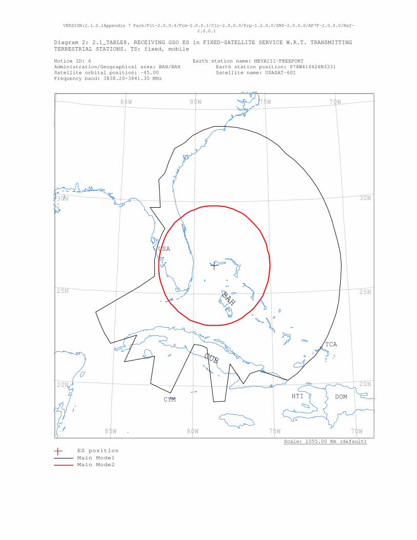
VERSION:2.1.0.1Appendix 7 Pack/Plt-2.0.0.4/Frm-2.0.0.1/Clc-2.0.0.0/Prp-1.2.0.0/SNS-2.0.0.0/AP7F-2.0.0.0/Ref-2.0.0.1
Diagram 2: 2.1_TABLE8. RECEIVING GSO ES in FIXED-SATELLITE SERVICE W.R.T. TRANSMITTING TERRESTRIAL STATIONS. TS: fixed, mobile Notice ID: 6 Earth station name: MEVAIII-FREEPORT Administration/Geographical area: BAH/BAH Earth station position: 078W414426N3331 Satellite orbital position: -45.00 Satellite name: USASAT-60I Frequency band: 3838.20-3841.30 MHz
Scale: 1055.00 Km (default)
USA
TCA
HTI DOMCYM
CUB
BAH
70W 75W 80W 85W
70W 75W 80W 85W
30N
25N
20N
30N
25N
20N
ES positionMain Mode1 Main Mode2
VERSION:2.1.0.1Appendix 7 Pack/Plt-2.0.0.4/Frm-2.0.0.1/Clc-2.0.0.0/Prp-1.2.0.0/SNS-2.0.0.0/AP7F-2.0.0.0/Ref-2.0.0.1
Diagram 2: 2.1_TABLE8. RECEIVING GSO ES in FIXED-SATELLITE SERVICE W.R.T. TRANSMITTING TERRESTRIAL STATIONS. TS: fixed, mobile
NOTICE ID: 6 EARTH STATION NAME: MEVAIII-FREEPORT EARTH STATION POSITION: 078W414426N3331 PHASE: D ADM/GEO_AREA: BAH/BAH RAIN CLIMATICAL ZONE: N SATELLITE NAME: USASAT-60I SATELLITE ORBITAL POSITION: -45.00 DEG ANTENNA AZIMUTH: 123.84 DEG ANTENNA ELEVATION: 41.61 DEG FREQUENCY BAND: 3838.20-3841.30 MHZ ASSIGNED FREQUENCY: 3839.75 MHZ PERCENTAGE OF TIME: 0.0017 % MAXIMUM ANTENNA GAIN: 42.1 DBI MAXIMUM POWER DENSITY: - DBW/HZ NOISE TEMPERATURE: 400.0 K ANTENNA PATTERN: APEREC015V01 2.1_TABLE8 Model: PLM_DUCTING TRANSMISSION LOSS MODE 1: 198.9 DB (DOES NOT INCLUDE HOR. CORR. AND ANT. GAIN) TRANSMISSION LOSS MODE 2: 156.9 DB AZIMUTH 0 5 10 15 20 25 30 35 40 45 50 55 60 65 70 75 80 85 90 95 100 105 110 115 OFF-AXIS 114.6 111.1 107.6 104.0 100.3 96.6 92.9 89.1 85.4 81.7 78.0 74.3 70.8 67.2 63.8 60.5 57.4 54.4 51.6 49.1 46.8 45.0 43.4 42.4 HOR.ELEV. - - - - - - - - - - - - - - - - - - - - - - - - HOR.CORR. - - - - - - - - - - - - - - - - - - - - - - - - ANT.GAIN -6.9 -6.9 -6.9 -6.9 -6.9 -6.9 -6.9 -6.9 -6.9 -6.9 -6.9 -6.9 -6.9 -6.9 -6.9 -6.9 -6.9 -6.9 -6.9 -6.9 -6.6 -6.2 -5.8 -5.5 COORDINATION DISTANCE (KM) MODE 1 0.0 DB 837 840 845 845 845 841 836 822 822 822 821 820 819 818 815 814 819 826 829 830 833 841 847 851 MODE 2 0.0 DEG 361 361 361 362 362 362 362 363 363 363 363 364 364 364 364 364 364 365 365 365 365 365 365 365 AZIMUTH 120 125 130 135 140 145 150 155 160 165 170 175 180 185 190 195 200 205 210 215 220 225 230 235 OFF-AXIS 41.8 41.6 42.0 42.8 44.1 45.8 47.8 50.2 52.9 55.7 58.8 62.0 65.4 68.9 72.4 76.0 79.7 83.4 87.1 90.9 94.6 98.3 102.0 105.7 HOR.ELEV. - - - - - - - - - - - - - - - - - - - - - - - - HOR.CORR. - - - - - - - - - - - - - - - - - - - - - - - - ANT.GAIN -5.4 -5.3 -5.4 -5.6 -6.0 -6.4 -6.8 -6.9 -6.9 -6.9 -6.9 -6.9 -6.9 -6.9 -6.9 -6.9 -6.9 -6.9 -6.9 -6.9 -6.9 -6.9 -6.9 -6.9 COORDINATION DISTANCE (KM) MODE 1 0.0 DB 854 855 855 846 849 843 764 698 693 741 603 823 822 503 491 495 821 821 821 670 738 821 657 821 MODE 2 0.0 DEG 365 365 365 365 365 365 365 365 365 365 364 364 364 364 364 363 363 363 363 363 362 362 362 362 AZIMUTH 240 245 250 255 260 265 270 275 280 285 290 295 300 305 310 315 320 325 330 335 340 345 350 355 OFF-AXIS 109.2 112.8 116.2 119.5 122.6 125.6 128.4 130.9 133.2 135.0 136.6 137.6 138.2 138.4 138.0 137.2 135.9 134.2 132.2 129.8 127.1 124.3 121.2 118.0 HOR.ELEV. - - - - - - - - - - - - - - - - - - - - - - - - HOR.CORR. - - - - - - - - - - - - - - - - - - - - - - - - ANT.GAIN -6.9 -6.9 -6.9 -6.9 -6.9 -6.9 -6.9 -6.9 -6.9 -6.9 -6.9 -6.9 -6.9 -6.9 -6.9 -6.9 -6.9 -6.9 -6.9 -6.9 -6.9 -6.9 -6.9 -6.9 COORDINATION DISTANCE (KM) MODE 1 0.0 DB 820 820 819 499 392 386 386 386 386 386 386 387 388 388 542 497 549 629 642 693 751 761 795 819 MODE 2 0.0 DEG 361 361 361 361 361 360 360 360 360 360 360 360 360 360 360 360 360 360 360 360 360 361 361 361 PROBABLY AFFECTED COUNTRIES: CUB TCA USA
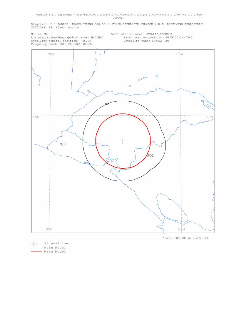
VERSION:2.1.0.1Appendix 7 Pack/Plt-2.0.0.4/Frm-2.0.0.1/Clc-2.0.0.0/Prp-1.2.0.0/SNS-2.0.0.0/AP7F-2.0.0.0/Ref-2.0.0.1
Diagram 1: 2.1_TABLE7. TRANSMITTING GSO ES in FIXED-SATELLITE SERVICE W.R.T. RECEIVING TERRESTRIAL STATIONS. TS: fixed, mobile Notice ID: 5 Earth station name: MEVAIII-COCESNA Administration/Geographical area: HND/HND Earth station position: 087W130114N0342 Satellite orbital position: -45.00 Satellite name: USASAT-60I Frequency band: 6063.20-6066.30 MHz
Scale: 380.00 Km (default)
SLV
NCG
HND
85W 90W
85W 90W
15N15N
ES positionMain Mode1 Main Mode2

VERSION:2.1.0.1Appendix 7 Pack/Plt-2.0.0.4/Frm-2.0.0.1/Clc-2.0.0.0/Prp-1.2.0.0/SNS-2.0.0.0/AP7F-2.0.0.0/Ref-2.0.0.1
Diagram 1: 2.1_TABLE7. TRANSMITTING GSO ES in FIXED-SATELLITE SERVICE W.R.T. RECEIVING TERRESTRIAL STATIONS. TS: fixed, mobile
NOTICE ID: 5 EARTH STATION NAME: MEVAIII-COCESNA EARTH STATION POSITION: 087W130114N0342 PHASE: D ADM/GEO_AREA: HND/HND RAIN CLIMATICAL ZONE: P SATELLITE NAME: USASAT-60I SATELLITE ORBITAL POSITION: -45.00 DEG ANTENNA AZIMUTH: 104.99 DEG ANTENNA ELEVATION: 39.20 DEG FREQUENCY BAND: 6063.20-6066.30 MHZ ASSIGNED FREQUENCY: 6064.75 MHZ PERCENTAGE OF TIME: 0.0050 % MAXIMUM ANTENNA GAIN: 49.0 DBI MAXIMUM POWER DENSITY: -53.9 DBW/HZ NOISE TEMPERATURE: - K ANTENNA PATTERN: APEREC015V01 2.1_TABLE7 Model: PLM_DUCTING TRANSMISSION LOSS MODE 1: 159.1 DB (DOES NOT INCLUDE HOR. CORR. AND ANT. GAIN) TRANSMISSION LOSS MODE 2: 113.1 DB AZIMUTH 0 5 10 15 20 25 30 35 40 45 50 55 60 65 70 75 80 85 90 95 100 105 110 115 OFF-AXIS 101.6 97.7 93.9 90.0 86.1 82.3 78.4 74.6 70.9 67.2 63.6 60.1 56.8 53.6 50.6 47.8 45.4 43.3 41.5 40.3 39.5 39.2 39.5 40.3 HOR.ELEV. - - - - - - - - - - - - - - - - - - - - - - - - HOR.CORR. - - - - - - - - - - - - - - - - - - - - - - - - ANT.GAIN -10.0 -10.0 -10.0 -10.0 -10.0 -10.0 -10.0 -10.0 -10.0 -10.0 -10.0 -10.0 -10.0 -10.0 -10.0 -10.0 -9.4 -8.9 -8.5 -8.1 -7.9 -7.8 -7.9 -8.1 COORDINATION DISTANCE (KM) MODE 1 0.0 DB 166 166 166 166 166 166 166 166 166 166 166 166 166 166 166 166 170 173 176 178 180 180 180 178 MODE 2 0.0 DEG 112 112 112 112 112 112 113 113 113 114 114 114 114 114 114 115 115 115 115 115 115 115 115 115 AZIMUTH 120 125 130 135 140 145 150 155 160 165 170 175 180 185 190 195 200 205 210 215 220 225 230 235 OFF-AXIS 41.5 43.3 45.4 47.9 50.6 53.6 56.8 60.1 63.6 67.2 70.9 74.6 78.4 82.3 86.1 90.0 93.9 97.7 101.6 105.4 109.1 112.8 116.4 119.9 HOR.ELEV. - - - - - - - - - - - - - - - - - - - - - - - - HOR.CORR. - - - - - - - - - - - - - - - - - - - - - - - - ANT.GAIN -8.5 -8.9 -9.4 -10.0 -10.0 -10.0 -10.0 -10.0 -10.0 -10.0 -10.0 -10.0 -10.0 -10.0 -10.0 -10.0 -10.0 -10.0 -10.0 -10.0 -10.0 -10.0 -10.0 -10.0 COORDINATION DISTANCE (KM) MODE 1 0.0 DB 176 173 170 166 166 166 166 166 166 166 166 166 166 166 166 166 166 166 166 166 166 166 166 166 MODE 2 0.0 DEG 115 115 115 115 114 114 114 114 114 114 113 113 113 112 112 112 112 112 112 112 112 112 112 112 AZIMUTH 240 245 250 255 260 265 270 275 280 285 290 295 300 305 310 315 320 325 330 335 340 345 350 355 OFF-AXIS 123.2 126.4 129.4 132.2 134.6 136.7 138.5 139.7 140.5 140.8 140.5 139.7 138.5 136.7 134.6 132.1 129.4 126.4 123.2 119.9 116.4 112.8 109.1 105.4 HOR.ELEV. - - - - - - - - - - - - - - - - - - - - - - - - HOR.CORR. - - - - - - - - - - - - - - - - - - - - - - - - ANT.GAIN -10.0 -10.0 -10.0 -10.0 -10.0 -10.0 -10.0 -10.0 -10.0 -10.0 -10.0 -10.0 -10.0 -10.0 -10.0 -10.0 -10.0 -10.0 -10.0 -10.0 -10.0 -10.0 -10.0 -10.0 COORDINATION DISTANCE (KM) MODE 1 0.0 DB 166 166 166 166 166 166 166 166 166 166 166 166 166 166 166 166 166 166 166 166 166 166 166 166 MODE 2 0.0 DEG 112 112 112 112 112 112 112 112 112 112 112 112 112 112 112 112 112 112 112 112 112 112 112 112 PROBABLY AFFECTED COUNTRIES: NCG SLV
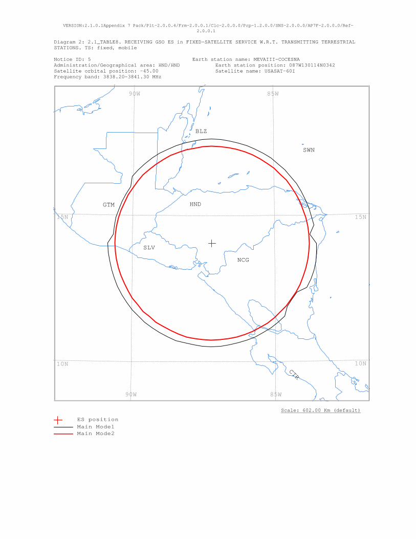
VERSION:2.1.0.1Appendix 7 Pack/Plt-2.0.0.4/Frm-2.0.0.1/Clc-2.0.0.0/Prp-1.2.0.0/SNS-2.0.0.0/AP7F-2.0.0.0/Ref-2.0.0.1
Diagram 2: 2.1_TABLE8. RECEIVING GSO ES in FIXED-SATELLITE SERVICE W.R.T. TRANSMITTING TERRESTRIAL STATIONS. TS: fixed, mobile Notice ID: 5 Earth station name: MEVAIII-COCESNA Administration/Geographical area: HND/HND Earth station position: 087W130114N0342 Satellite orbital position: -45.00 Satellite name: USASAT-60I Frequency band: 3838.20-3841.30 MHz
Scale: 602.00 Km (default)
SWN
SLV
NCG
HNDGTM
CTR
BLZ
85W 90W
85W 90W
15N
10N
15N
10N
ES positionMain Mode1 Main Mode2

VERSION:2.1.0.1Appendix 7 Pack/Plt-2.0.0.4/Frm-2.0.0.1/Clc-2.0.0.0/Prp-1.2.0.0/SNS-2.0.0.0/AP7F-2.0.0.0/Ref-2.0.0.1
Diagram 2: 2.1_TABLE8. RECEIVING GSO ES in FIXED-SATELLITE SERVICE W.R.T. TRANSMITTING TERRESTRIAL STATIONS. TS: fixed, mobile
NOTICE ID: 5 EARTH STATION NAME: MEVAIII-COCESNA EARTH STATION POSITION: 087W130114N0342 PHASE: D ADM/GEO_AREA: HND/HND RAIN CLIMATICAL ZONE: P SATELLITE NAME: USASAT-60I SATELLITE ORBITAL POSITION: -45.00 DEG ANTENNA AZIMUTH: 104.99 DEG ANTENNA ELEVATION: 39.20 DEG FREQUENCY BAND: 3838.20-3841.30 MHZ ASSIGNED FREQUENCY: 3839.75 MHZ PERCENTAGE OF TIME: 0.0017 % MAXIMUM ANTENNA GAIN: 42.1 DBI MAXIMUM POWER DENSITY: - DBW/HZ NOISE TEMPERATURE: 400.0 K ANTENNA PATTERN: APEREC015V01 2.1_TABLE8 Model: PLM_DUCTING TRANSMISSION LOSS MODE 1: 198.9 DB (DOES NOT INCLUDE HOR. CORR. AND ANT. GAIN) TRANSMISSION LOSS MODE 2: 156.9 DB AZIMUTH 0 5 10 15 20 25 30 35 40 45 50 55 60 65 70 75 80 85 90 95 100 105 110 115 OFF-AXIS 101.6 97.7 93.9 90.0 86.1 82.3 78.4 74.6 70.9 67.2 63.6 60.1 56.8 53.6 50.6 47.8 45.4 43.3 41.5 40.3 39.5 39.2 39.5 40.3 HOR.ELEV. - - - - - - - - - - - - - - - - - - - - - - - - HOR.CORR. - - - - - - - - - - - - - - - - - - - - - - - - ANT.GAIN -6.9 -6.9 -6.9 -6.9 -6.9 -6.9 -6.9 -6.9 -6.9 -6.9 -6.9 -6.9 -6.9 -6.9 -6.9 -6.8 -6.3 -5.8 -5.3 -5.0 -4.8 -4.7 -4.8 -5.0 COORDINATION DISTANCE (KM) MODE 1 0.0 DB 394 394 394 394 394 394 394 394 394 394 394 394 394 394 394 394 396 375 400 401 402 402 402 401 MODE 2 0.0 DEG 368 368 369 369 369 369 370 370 370 370 371 371 371 371 371 371 372 372 372 372 372 372 372 372 AZIMUTH 120 125 130 135 140 145 150 155 160 165 170 175 180 185 190 195 200 205 210 215 220 225 230 235 OFF-AXIS 41.5 43.3 45.4 47.9 50.6 53.6 56.8 60.1 63.6 67.2 70.9 74.6 78.4 82.3 86.1 90.0 93.9 97.7 101.6 105.4 109.1 112.8 116.4 119.9 HOR.ELEV. - - - - - - - - - - - - - - - - - - - - - - - - HOR.CORR. - - - - - - - - - - - - - - - - - - - - - - - - ANT.GAIN -5.3 -5.8 -6.3 -6.9 -6.9 -6.9 -6.9 -6.9 -6.9 -6.9 -6.9 -6.9 -6.9 -6.9 -6.9 -6.9 -6.9 -6.9 -6.9 -6.9 -6.9 -6.9 -6.9 -6.9 COORDINATION DISTANCE (KM) MODE 1 0.0 DB 375 375 375 394 394 394 394 394 394 394 394 394 394 394 394 394 396 394 394 394 394 394 394 394 MODE 2 0.0 DEG 372 372 372 371 371 371 371 371 371 370 370 370 370 369 369 369 369 368 368 368 367 367 367 367 AZIMUTH 240 245 250 255 260 265 270 275 280 285 290 295 300 305 310 315 320 325 330 335 340 345 350 355 OFF-AXIS 123.2 126.4 129.4 132.2 134.6 136.7 138.5 139.7 140.5 140.8 140.5 139.7 138.5 136.7 134.6 132.1 129.4 126.4 123.2 119.9 116.4 112.8 109.1 105.4 HOR.ELEV. - - - - - - - - - - - - - - - - - - - - - - - - HOR.CORR. - - - - - - - - - - - - - - - - - - - - - - - - ANT.GAIN -6.9 -6.9 -6.9 -6.9 -6.9 -6.9 -6.9 -6.9 -6.9 -6.9 -6.9 -6.9 -6.9 -6.9 -6.9 -6.9 -6.9 -6.9 -6.9 -6.9 -6.9 -6.9 -6.9 -6.9 COORDINATION DISTANCE (KM) MODE 1 0.0 DB 394 394 394 394 394 394 394 375 375 375 375 375 375 375 394 394 394 394 394 394 394 394 394 394 MODE 2 0.0 DEG 367 366 366 366 366 366 366 366 366 366 366 366 366 366 366 366 366 366 367 367 367 367 367 368 PROBABLY AFFECTED COUNTRIES: BLZ CTR GTM NCG SLV

VERSION:2.1.0.1Appendix 7 Pack/Plt-2.0.0.4/Frm-2.0.0.1/Clc-2.0.0.0/Prp-1.2.0.0/SNS-2.0.0.0/AP7F-2.0.0.0/Ref-2.0.0.1
Diagram 1: 2.1_TABLE7. TRANSMITTING GSO ES in FIXED-SATELLITE SERVICE W.R.T. RECEIVING TERRESTRIAL STATIONS. TS: fixed, mobile Notice ID: 3 Earth station name: MEVAIII-CARACAS Administration/Geographical area: VEN/VEN Earth station position: 066W592610N3611 Satellite orbital position: -45.00 Satellite name: USASAT-60I Frequency band: 6063.20-6066.30 MHz
Scale: 440.00 Km (default)
VEN
CUWBES
ABW
65W 70W
65W 70W
10N10N
ES positionMain Mode1 Main Mode2

VERSION:2.1.0.1Appendix 7 Pack/Plt-2.0.0.4/Frm-2.0.0.1/Clc-2.0.0.0/Prp-1.2.0.0/SNS-2.0.0.0/AP7F-2.0.0.0/Ref-2.0.0.1
Diagram 1: 2.1_TABLE7. TRANSMITTING GSO ES in FIXED-SATELLITE SERVICE W.R.T. RECEIVING TERRESTRIAL STATIONS. TS: fixed, mobile
NOTICE ID: 3 EARTH STATION NAME: MEVAIII-CARACAS EARTH STATION POSITION: 066W592610N3611 PHASE: D ADM/GEO_AREA: VEN/VEN RAIN CLIMATICAL ZONE: N SATELLITE NAME: USASAT-60I SATELLITE ORBITAL POSITION: -45.00 DEG ANTENNA AZIMUTH: 114.50 DEG ANTENNA ELEVATION: 61.58 DEG FREQUENCY BAND: 6063.20-6066.30 MHZ ASSIGNED FREQUENCY: 6064.75 MHZ PERCENTAGE OF TIME: 0.0050 % MAXIMUM ANTENNA GAIN: 49.0 DBI MAXIMUM POWER DENSITY: -53.1 DBW/HZ NOISE TEMPERATURE: - K ANTENNA PATTERN: APEREC015V01 2.1_TABLE7 Model: PLM_DUCTING TRANSMISSION LOSS MODE 1: 159.9 DB (DOES NOT INCLUDE HOR. CORR. AND ANT. GAIN) TRANSMISSION LOSS MODE 2: 113.9 DB AZIMUTH 0 5 10 15 20 25 30 35 40 45 50 55 60 65 70 75 80 85 90 95 100 105 110 115 OFF-AXIS 101.4 99.1 96.8 94.5 92.1 89.8 87.4 85.0 82.7 80.4 78.2 76.0 74.0 72.0 70.2 68.5 66.9 65.5 64.3 63.3 62.6 62.0 61.7 61.6 HOR.ELEV. - - - - - - - - - - - - - - - - - - - - - - - - HOR.CORR. - - - - - - - - - - - - - - - - - - - - - - - - ANT.GAIN -10.0 -10.0 -10.0 -10.0 -10.0 -10.0 -10.0 -10.0 -10.0 -10.0 -10.0 -10.0 -10.0 -10.0 -10.0 -10.0 -10.0 -10.0 -10.0 -10.0 -10.0 -10.0 -10.0 -10.0 COORDINATION DISTANCE (KM) MODE 1 0.0 DB 208 208 208 208 208 208 240 239 240 240 240 240 240 240 240 240 239 229 183 173 173 173 173 173 MODE 2 0.0 DEG 114 114 114 114 114 114 114 114 114 114 115 115 115 115 115 115 115 115 115 115 115 115 115 115 AZIMUTH 120 125 130 135 140 145 150 155 160 165 170 175 180 185 190 195 200 205 210 215 220 225 230 235 OFF-AXIS 61.7 62.1 62.7 63.5 64.6 65.8 67.2 68.8 70.5 72.4 74.4 76.4 78.6 80.9 83.2 85.5 87.9 90.2 92.6 95.0 97.3 99.6 101.8 104.0 HOR.ELEV. - - - - - - - - - - - - - - - - - - - - - - - - HOR.CORR. - - - - - - - - - - - - - - - - - - - - - - - - ANT.GAIN -10.0 -10.0 -10.0 -10.0 -10.0 -10.0 -10.0 -10.0 -10.0 -10.0 -10.0 -10.0 -10.0 -10.0 -10.0 -10.0 -10.0 -10.0 -10.0 -10.0 -10.0 -10.0 -10.0 -10.0 COORDINATION DISTANCE (KM) MODE 1 0.0 DB 173 173 173 173 173 173 173 173 173 173 173 173 173 173 173 173 173 173 173 173 173 173 173 173 MODE 2 0.0 DEG 115 115 115 115 115 115 115 115 115 115 115 115 115 114 114 114 114 114 114 114 114 114 114 114 AZIMUTH 240 245 250 255 260 265 270 275 280 285 290 295 300 305 310 315 320 325 330 335 340 345 350 355 OFF-AXIS 106.0 108.0 109.8 111.5 113.1 114.5 115.7 116.7 117.4 118.0 118.3 118.4 118.3 117.9 117.3 116.5 115.4 114.2 112.8 111.2 109.5 107.6 105.6 103.6 HOR.ELEV. - - - - - - - - - - - - - - - - - - - - - - - - HOR.CORR. - - - - - - - - - - - - - - - - - - - - - - - - ANT.GAIN -10.0 -10.0 -10.0 -10.0 -10.0 -10.0 -10.0 -10.0 -10.0 -10.0 -10.0 -10.0 -10.0 -10.0 -10.0 -10.0 -10.0 -10.0 -10.0 -10.0 -10.0 -10.0 -10.0 -10.0 COORDINATION DISTANCE (KM) MODE 1 0.0 DB 173 173 173 173 176 198 205 193 190 211 213 229 240 240 240 240 239 240 240 240 240 240 240 208 MODE 2 0.0 DEG 114 114 114 114 114 114 114 114 114 114 114 114 114 114 114 114 114 114 114 114 114 114 114 114 PROBABLY AFFECTED COUNTRIES: BES
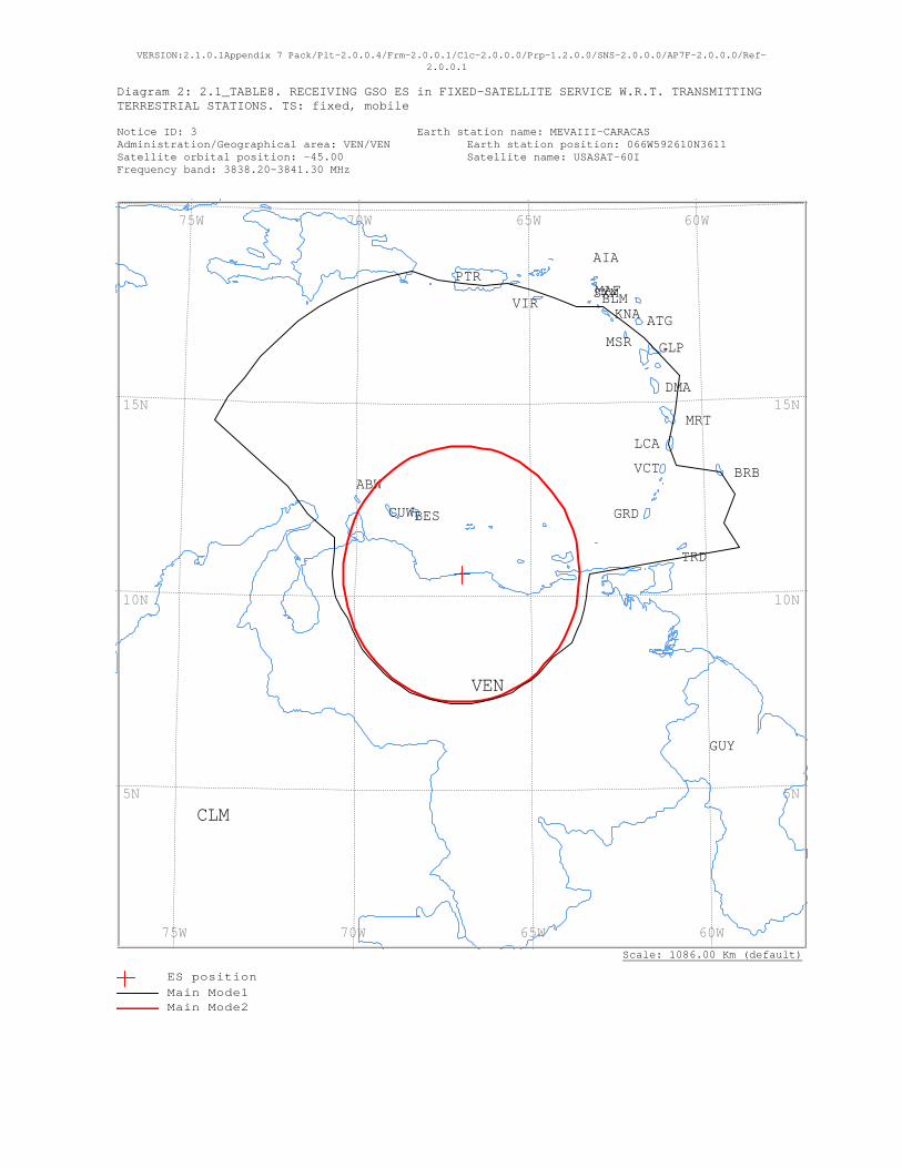
VERSION:2.1.0.1Appendix 7 Pack/Plt-2.0.0.4/Frm-2.0.0.1/Clc-2.0.0.0/Prp-1.2.0.0/SNS-2.0.0.0/AP7F-2.0.0.0/Ref-2.0.0.1
Diagram 2: 2.1_TABLE8. RECEIVING GSO ES in FIXED-SATELLITE SERVICE W.R.T. TRANSMITTING TERRESTRIAL STATIONS. TS: fixed, mobile Notice ID: 3 Earth station name: MEVAIII-CARACAS Administration/Geographical area: VEN/VEN Earth station position: 066W592610N3611 Satellite orbital position: -45.00 Satellite name: USASAT-60I Frequency band: 3838.20-3841.30 MHz
Scale: 1086.00 Km (default)
VIR
VEN
VCT
TRD
SXMPTR
MSR
MRT
MAF
LCA
KNA
GUY
GRD
GLP
DMA
CUW
CLM
BRB
BLM
BES
ATG
AIA
ABW
60W 65W 70W 75W
60W 65W 70W 75W
15N
10N
5N
15N
10N
5N
ES positionMain Mode1 Main Mode2

VERSION:2.1.0.1Appendix 7 Pack/Plt-2.0.0.4/Frm-2.0.0.1/Clc-2.0.0.0/Prp-1.2.0.0/SNS-2.0.0.0/AP7F-2.0.0.0/Ref-2.0.0.1
Diagram 2: 2.1_TABLE8. RECEIVING GSO ES in FIXED-SATELLITE SERVICE W.R.T. TRANSMITTING TERRESTRIAL STATIONS. TS: fixed, mobile
NOTICE ID: 3 EARTH STATION NAME: MEVAIII-CARACAS EARTH STATION POSITION: 066W592610N3611 PHASE: D ADM/GEO_AREA: VEN/VEN RAIN CLIMATICAL ZONE: N SATELLITE NAME: USASAT-60I SATELLITE ORBITAL POSITION: -45.00 DEG ANTENNA AZIMUTH: 114.50 DEG ANTENNA ELEVATION: 61.58 DEG FREQUENCY BAND: 3838.20-3841.30 MHZ ASSIGNED FREQUENCY: 3839.75 MHZ PERCENTAGE OF TIME: 0.0017 % MAXIMUM ANTENNA GAIN: 42.1 DBI MAXIMUM POWER DENSITY: - DBW/HZ NOISE TEMPERATURE: 400.0 K ANTENNA PATTERN: APEREC015V01 2.1_TABLE8 Model: PLM_DUCTING TRANSMISSION LOSS MODE 1: 198.9 DB (DOES NOT INCLUDE HOR. CORR. AND ANT. GAIN) TRANSMISSION LOSS MODE 2: 156.9 DB AZIMUTH 0 5 10 15 20 25 30 35 40 45 50 55 60 65 70 75 80 85 90 95 100 105 110 115 OFF-AXIS 101.4 99.1 96.8 94.5 92.1 89.8 87.4 85.0 82.7 80.4 78.2 76.0 74.0 72.0 70.2 68.5 66.9 65.5 64.3 63.3 62.6 62.0 61.7 61.6 HOR.ELEV. - - - - - - - - - - - - - - - - - - - - - - - - HOR.CORR. - - - - - - - - - - - - - - - - - - - - - - - - ANT.GAIN -6.9 -6.9 -6.9 -6.9 -6.9 -6.9 -6.9 -6.9 -6.9 -6.9 -6.9 -6.9 -6.9 -6.9 -6.9 -6.9 -6.9 -6.9 -6.9 -6.9 -6.9 -6.9 -6.9 -6.9 COORDINATION DISTANCE (KM) MODE 1 0.0 DB 835 831 847 847 847 847 886 885 886 886 886 813 747 738 859 886 834 872 402 397 397 397 397 397 MODE 2 0.0 DEG 368 368 368 369 369 369 369 369 369 369 369 369 370 370 370 370 370 370 370 370 370 370 370 370 AZIMUTH 120 125 130 135 140 145 150 155 160 165 170 175 180 185 190 195 200 205 210 215 220 225 230 235 OFF-AXIS 61.7 62.1 62.7 63.5 64.6 65.8 67.2 68.8 70.5 72.4 74.4 76.4 78.6 80.9 83.2 85.5 87.9 90.2 92.6 95.0 97.3 99.6 101.8 104.0 HOR.ELEV. - - - - - - - - - - - - - - - - - - - - - - - - HOR.CORR. - - - - - - - - - - - - - - - - - - - - - - - - ANT.GAIN -6.9 -6.9 -6.9 -6.9 -6.9 -6.9 -6.9 -6.9 -6.9 -6.9 -6.9 -6.9 -6.9 -6.9 -6.9 -6.9 -6.9 -6.9 -6.9 -6.9 -6.9 -6.9 -6.9 -6.9 COORDINATION DISTANCE (KM) MODE 1 0.0 DB 397 383 376 375 375 375 375 375 375 375 375 375 375 375 375 375 375 375 375 375 375 375 376 376 MODE 2 0.0 DEG 370 370 370 370 370 370 370 370 370 370 370 369 369 369 369 369 369 369 369 369 368 368 368 368 AZIMUTH 240 245 250 255 260 265 270 275 280 285 290 295 300 305 310 315 320 325 330 335 340 345 350 355 OFF-AXIS 106.0 108.0 109.8 111.5 113.1 114.5 115.7 116.7 117.4 118.0 118.3 118.4 118.3 117.9 117.3 116.5 115.4 114.2 112.8 111.2 109.5 107.6 105.6 103.6 HOR.ELEV. - - - - - - - - - - - - - - - - - - - - - - - - HOR.CORR. - - - - - - - - - - - - - - - - - - - - - - - - ANT.GAIN -6.9 -6.9 -6.9 -6.9 -6.9 -6.9 -6.9 -6.9 -6.9 -6.9 -6.9 -6.9 -6.9 -6.9 -6.9 -6.9 -6.9 -6.9 -6.9 -6.9 -6.9 -6.9 -6.9 -6.9 COORDINATION DISTANCE (KM) MODE 1 0.0 DB 376 376 376 388 398 399 400 401 402 410 510 595 886 886 882 886 885 886 886 886 886 886 886 847 MODE 2 0.0 DEG 368 368 368 368 368 368 368 368 367 367 367 367 367 367 367 368 368 368 368 368 368 368 368 368 PROBABLY AFFECTED COUNTRIES: ABW BES BRB CLM CUW DMA DOM GLP GRD KNA LCA MRT MSR PTR TRD VCT VIR
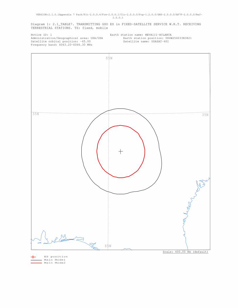
VERSION:2.1.0.1Appendix 7 Pack/Plt-2.0.0.4/Frm-2.0.0.1/Clc-2.0.0.0/Prp-1.2.0.0/SNS-2.0.0.0/AP7F-2.0.0.0/Ref-2.0.0.1
Diagram 1: 2.1_TABLE7. TRANSMITTING GSO ES in FIXED-SATELLITE SERVICE W.R.T. RECEIVING TERRESTRIAL STATIONS. TS: fixed, mobile Notice ID: 1 Earth station name: MEVAIII-ATLANTA Administration/Geographical area: USA/USA Earth station position: 084W254033N3821 Satellite orbital position: -45.00 Satellite name: USASAT-60I Frequency band: 6063.20-6066.30 MHz
Scale: 400.00 Km (default)
85W
85W
35N35N
ES positionMain Mode1 Main Mode2

VERSION:2.1.0.1Appendix 7 Pack/Plt-2.0.0.4/Frm-2.0.0.1/Clc-2.0.0.0/Prp-1.2.0.0/SNS-2.0.0.0/AP7F-2.0.0.0/Ref-2.0.0.1
Diagram 1: 2.1_TABLE7. TRANSMITTING GSO ES in FIXED-SATELLITE SERVICE W.R.T. RECEIVING TERRESTRIAL STATIONS. TS: fixed, mobile
NOTICE ID: 1 EARTH STATION NAME: MEVAIII-ATLANTA EARTH STATION POSITION: 084W254033N3821 PHASE: D ADM/GEO_AREA: USA/USA RAIN CLIMATICAL ZONE: M SATELLITE NAME: USASAT-60I SATELLITE ORBITAL POSITION: -45.00 DEG ANTENNA AZIMUTH: 123.97 DEG ANTENNA ELEVATION: 32.72 DEG FREQUENCY BAND: 6063.20-6066.30 MHZ ASSIGNED FREQUENCY: 6064.75 MHZ PERCENTAGE OF TIME: 0.0050 % MAXIMUM ANTENNA GAIN: 49.0 DBI MAXIMUM POWER DENSITY: -50.9 DBW/HZ NOISE TEMPERATURE: - K ANTENNA PATTERN: APEREC015V01 2.1_TABLE7 Model: PLM_DUCTING TRANSMISSION LOSS MODE 1: 162.1 DB (DOES NOT INCLUDE HOR. CORR. AND ANT. GAIN) TRANSMISSION LOSS MODE 2: 116.1 DB AZIMUTH 0 5 10 15 20 25 30 35 40 45 50 55 60 65 70 75 80 85 90 95 100 105 110 115 OFF-AXIS 118.0 114.0 110.0 105.9 101.7 97.5 93.3 89.1 84.9 80.7 76.6 72.4 68.3 64.3 60.3 56.5 52.7 49.1 45.8 42.6 39.8 37.3 35.3 33.8 HOR.ELEV. - - - - - - - - - - - - - - - - - - - - - - - - HOR.CORR. - - - - - - - - - - - - - - - - - - - - - - - - ANT.GAIN -10.0 -10.0 -10.0 -10.0 -10.0 -10.0 -10.0 -10.0 -10.0 -10.0 -10.0 -10.0 -10.0 -10.0 -10.0 -10.0 -10.0 -10.0 -9.5 -8.7 -8.0 -7.3 -6.7 -6.2 COORDINATION DISTANCE (KM) MODE 1 0.0 DB 173 173 173 173 173 173 173 173 173 173 173 173 173 173 173 173 173 173 177 181 186 191 195 198 MODE 2 0.0 DEG 105 105 105 105 105 105 105 105 105 106 106 106 106 107 107 107 107 108 108 108 108 108 108 108 AZIMUTH 120 125 130 135 140 145 150 155 160 165 170 175 180 185 190 195 200 205 210 215 220 225 230 235 OFF-AXIS 32.9 32.7 33.2 34.3 36.0 38.3 40.9 43.9 47.1 50.6 54.3 58.1 62.0 66.0 70.0 74.1 78.3 82.5 86.7 90.9 95.1 99.3 103.4 107.6 HOR.ELEV. - - - - - - - - - - - - - - - - - - - - - - - - HOR.CORR. - - - - - - - - - - - - - - - - - - - - - - - - ANT.GAIN -5.9 -5.9 -6.0 -6.4 -6.9 -7.6 -8.3 -9.1 -9.8 -10.0 -10.0 -10.0 -10.0 -10.0 -10.0 -10.0 -10.0 -10.0 -10.0 -10.0 -10.0 -10.0 -10.0 -10.0 COORDINATION DISTANCE (KM) MODE 1 0.0 DB 199 200 199 196 193 189 184 179 174 173 173 173 173 173 173 173 173 173 173 173 173 173 173 173 MODE 2 0.0 DEG 108 108 108 108 108 108 108 108 108 107 107 107 107 107 106 106 106 105 105 105 105 105 105 105 AZIMUTH 240 245 250 255 260 265 270 275 280 285 290 295 300 305 310 315 320 325 330 335 340 345 350 355 OFF-AXIS 111.7 115.7 119.7 123.5 127.3 130.9 134.2 137.4 140.2 142.7 144.7 146.2 147.1 147.3 146.8 145.7 144.0 141.7 139.1 136.1 132.9 129.4 125.7 121.9 HOR.ELEV. - - - - - - - - - - - - - - - - - - - - - - - - HOR.CORR. - - - - - - - - - - - - - - - - - - - - - - - - ANT.GAIN -10.0 -10.0 -10.0 -10.0 -10.0 -10.0 -10.0 -10.0 -10.0 -10.0 -10.0 -10.0 -10.0 -10.0 -10.0 -10.0 -10.0 -10.0 -10.0 -10.0 -10.0 -10.0 -10.0 -10.0 COORDINATION DISTANCE (KM) MODE 1 0.0 DB 173 173 173 173 173 173 173 173 173 173 173 173 173 173 173 173 173 173 173 173 173 173 173 173 MODE 2 0.0 DEG 105 105 105 105 105 105 105 105 105 105 105 105 105 105 105 105 105 105 105 105 105 105 105 105 PROBABLY AFFECTED COUNTRIES:
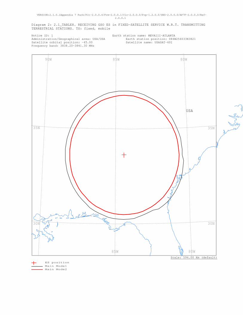
VERSION:2.1.0.1Appendix 7 Pack/Plt-2.0.0.4/Frm-2.0.0.1/Clc-2.0.0.0/Prp-1.2.0.0/SNS-2.0.0.0/AP7F-2.0.0.0/Ref-2.0.0.1
Diagram 2: 2.1_TABLE8. RECEIVING GSO ES in FIXED-SATELLITE SERVICE W.R.T. TRANSMITTING TERRESTRIAL STATIONS. TS: fixed, mobile Notice ID: 1 Earth station name: MEVAIII-ATLANTA Administration/Geographical area: USA/USA Earth station position: 084W254033N3821 Satellite orbital position: -45.00 Satellite name: USASAT-60I Frequency band: 3838.20-3841.30 MHz
Scale: 594.00 Km (default)
USA
80W 85W 90W
80W 85W
35N
30N
35N
30N
ES positionMain Mode1 Main Mode2
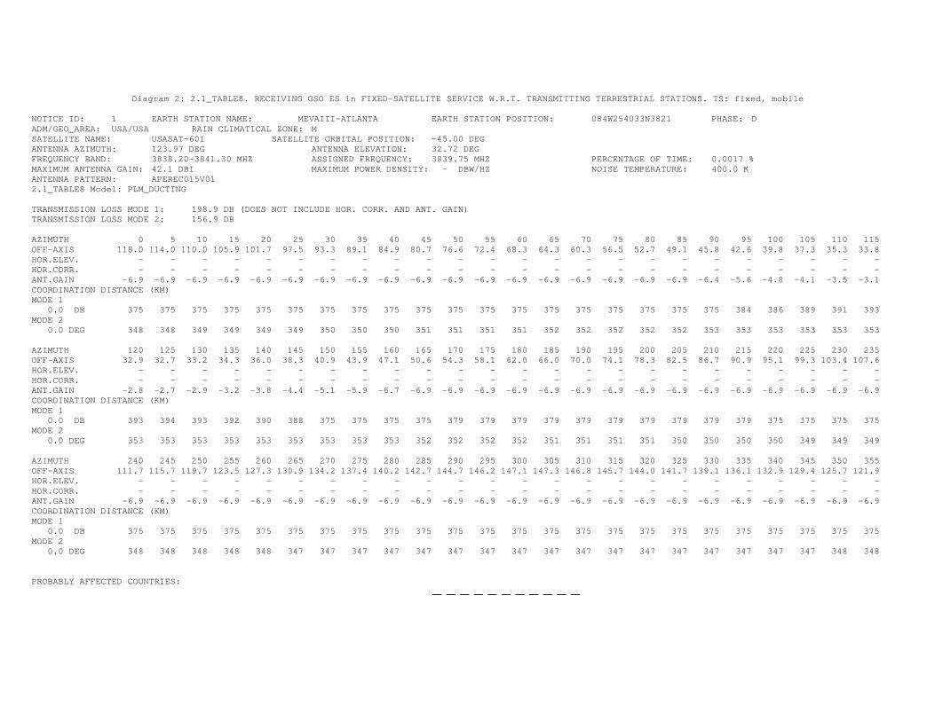
Diagram 2: 2.1_TABLE8. RECEIVING GSO ES in FIXED-SATELLITE SERVICE W.R.T. TRANSMITTING TERRESTRIAL STATIONS. TS: fixed, mobile
NOTICE ID: 1 EARTH STATION NAME: MEVAIII-ATLANTA EARTH STATION POSITION: 084W254033N3821 PHASE: D ADM/GEO_AREA: USA/USA RAIN CLIMATICAL ZONE: M SATELLITE NAME: USASAT-60I SATELLITE ORBITAL POSITION: -45.00 DEG ANTENNA AZIMUTH: 123.97 DEG ANTENNA ELEVATION: 32.72 DEG FREQUENCY BAND: 3838.20-3841.30 MHZ ASSIGNED FREQUENCY: 3839.75 MHZ PERCENTAGE OF TIME: 0.0017 % MAXIMUM ANTENNA GAIN: 42.1 DBI MAXIMUM POWER DENSITY: - DBW/HZ NOISE TEMPERATURE: 400.0 K ANTENNA PATTERN: APEREC015V01 2.1_TABLE8 Model: PLM_DUCTING TRANSMISSION LOSS MODE 1: 198.9 DB (DOES NOT INCLUDE HOR. CORR. AND ANT. GAIN) TRANSMISSION LOSS MODE 2: 156.9 DB AZIMUTH 0 5 10 15 20 25 30 35 40 45 50 55 60 65 70 75 80 85 90 95 100 105 110 115 OFF-AXIS 118.0 114.0 110.0 105.9 101.7 97.5 93.3 89.1 84.9 80.7 76.6 72.4 68.3 64.3 60.3 56.5 52.7 49.1 45.8 42.6 39.8 37.3 35.3 33.8 HOR.ELEV. - - - - - - - - - - - - - - - - - - - - - - - - HOR.CORR. - - - - - - - - - - - - - - - - - - - - - - - - ANT.GAIN -6.9 -6.9 -6.9 -6.9 -6.9 -6.9 -6.9 -6.9 -6.9 -6.9 -6.9 -6.9 -6.9 -6.9 -6.9 -6.9 -6.9 -6.9 -6.4 -5.6 -4.8 -4.1 -3.5 -3.1 COORDINATION DISTANCE (KM) MODE 1 0.0 DB 375 375 375 375 375 375 375 375 375 375 375 375 375 375 375 375 375 375 375 384 386 389 391 393 MODE 2 0.0 DEG 348 348 349 349 349 349 350 350 350 351 351 351 351 352 352 352 352 352 353 353 353 353 353 353 AZIMUTH 120 125 130 135 140 145 150 155 160 165 170 175 180 185 190 195 200 205 210 215 220 225 230 235 OFF-AXIS 32.9 32.7 33.2 34.3 36.0 38.3 40.9 43.9 47.1 50.6 54.3 58.1 62.0 66.0 70.0 74.1 78.3 82.5 86.7 90.9 95.1 99.3 103.4 107.6 HOR.ELEV. - - - - - - - - - - - - - - - - - - - - - - - - HOR.CORR. - - - - - - - - - - - - - - - - - - - - - - - - ANT.GAIN -2.8 -2.7 -2.9 -3.2 -3.8 -4.4 -5.1 -5.9 -6.7 -6.9 -6.9 -6.9 -6.9 -6.9 -6.9 -6.9 -6.9 -6.9 -6.9 -6.9 -6.9 -6.9 -6.9 -6.9 COORDINATION DISTANCE (KM) MODE 1 0.0 DB 393 394 393 392 390 388 375 375 375 375 379 379 379 379 379 379 379 379 379 379 375 375 375 375 MODE 2 0.0 DEG 353 353 353 353 353 353 353 353 353 352 352 352 352 351 351 351 351 350 350 350 350 349 349 349 AZIMUTH 240 245 250 255 260 265 270 275 280 285 290 295 300 305 310 315 320 325 330 335 340 345 350 355 OFF-AXIS 111.7 115.7 119.7 123.5 127.3 130.9 134.2 137.4 140.2 142.7 144.7 146.2 147.1 147.3 146.8 145.7 144.0 141.7 139.1 136.1 132.9 129.4 125.7 121.9 HOR.ELEV. - - - - - - - - - - - - - - - - - - - - - - - - HOR.CORR. - - - - - - - - - - - - - - - - - - - - - - - - ANT.GAIN -6.9 -6.9 -6.9 -6.9 -6.9 -6.9 -6.9 -6.9 -6.9 -6.9 -6.9 -6.9 -6.9 -6.9 -6.9 -6.9 -6.9 -6.9 -6.9 -6.9 -6.9 -6.9 -6.9 -6.9 COORDINATION DISTANCE (KM) MODE 1 0.0 DB 375 375 375 375 375 375 375 375 375 375 375 375 375 375 375 375 375 375 375 375 375 375 375 375 MODE 2 0.0 DEG 348 348 348 348 348 347 347 347 347 347 347 347 347 347 347 347 347 347 347 347 347 347 348 348 PROBABLY AFFECTED COUNTRIES:
— — — — — — — — — — —
APPENDIX C MEVA III TMG TERMS OF REFERENCE
1. Background
The MEVA Technical Management Group (TMG) originated from the MEVA Informal
Working Group (1998), as a standing group to address issues concerning the MEVA Network. The MEVA TMG was formally established in accordance to Conclusion 7/17 of the Seventh Meeting of the MEVA Network (MEVA/7) (Grand Cayman, Cayman Islands 15-17 May 2000). 2. Terms of Reference
In order to address the MEVA Network issues, the following activities are to be developed by the TMG:
a) Review the current status of the Network (maintenance and reporting procedures,
technical personnel involved, spare parts, tools for monitoring the Network status, identify common network points of failure, etc.) and submit recommendations;
b) Assist the MEVA Members in the coordination and technical solutions of the
problems presented in the operation and implementation of the AFS Services and the optimum frequency usage of the MEVA network. Likewise, to study and recommend measures to improve the operation and implementation fulfillment;
c) Study and propose to the MEVA Members intra and inter-regional coordination for the MEVA Network connectivity with other regional and domestic digital communications networks of the CAR,NAM and SAM Regions;
d) Study and assist the MEVA Members in measures of a technical character, in order to facilitate the operational benefits foreseen in the ICAO Aviation System Block upgrades (ASBU), transition of the MEVA Network towards the ATN infrastructure and its air-ground and ground-ground subnetworks of the air navigation services, implementation requirements from GREPECAS Conclusions and Recommendations, Implementation items from the NAM/CAR Implementation Groups, ICAO SARPs and technical guidance and the MEVA Members expectations; and
e) Inform and advise the MEVA Network Coordination, ICAO, if a major failure or network concern that affects the entire network occurs or may occur or an event that doesn´t allow achieving the Network Service level agreement, recommending solutions for its recovery and actions by the MEVA Network Service Provider.
-C2-
3. Work Programme
Attached
4. Working Methods
a) TMG work programme should present their activities in terms of objectives, responsible and deliverables. Further details can be provided in the form of Work Breakdown Schedule (WBS);
b) TMG will avoid duplication of work and maintain close coordination among the existing entities (like the Air Navigation Implementation Technical Group- ANI/WG), to optimize the use of available resources and experience;
c) TMG may designate, as necessary, ad-hoc groups or task forces to work on specific topics and activities; all tasks and activities should be clearly defined by time and deliverables;
d) TMG should coordinate and advance its works as follows to maximize efficiency and reduce costs: conduct work via electronic written correspondence : conduct work via phone and teleconference calls; and hold meetings when necessary and based on the work programme
activities; e) TMG will report the progress of assigned tasks to the Meetings of Directors of
Civil Aviation (DCA) of the Central Caribbean and other DCAs as required.
5. Membership
MEVA Members: Aruba, Bahamas (Nassau and Freeport), Cayman Islands, Cuba, Curacao, Dominican Republic, Jamaica, Haiti, Mexico, Panama, Sint Maarten, United States (Atlanta, Miami, Puerto Rico) and COCESNA.
The REDDIG Administration representing Colombia and Venezuela are participants / users of the MEVA Network.
ICAO will act as the MEVA Network Coordinator and as technical adviser to the TMG.
3. Rapporteur
Mrs. Dulce M. Roses (United States).

ME
VA
TM
G/29
C- 3
MEVA TMG Work Programme Revised: MEVA TMG/29 11 December 2014
No. Activities Objectives responsible deliverables 1 To assist the MEVA Members in coordination
for the solutions to problems presented in this operation, and in the implementation of services and frequency management matters.
Keep MEVA SLA levels
TMG MEVA assistance
2 To study and implement technical/operational measures that may be agreed upon to improve the operation and implementation of MEVA Network services, and that do not impact significant cost, investments and objectives of the Network.
Satisfactory operation and service levels
TMG Network improvements implementation
3 Keep MEVA Members aware of the status of the MEVA Network performance and conditions of operation.
MEVA Network awareness
TMG Reliable MEVA Network website Network Performance revision
4 Maintain valid and up-to-date MEVA Network Contingency Procedures, taking into consideration the contingency plans of each MEVA Member and of the Service Provider and in keeping with the CAR Region General Contingency Plan.
Readiness for contingencies
TMG MEVA Contingency Procedures
5 To assist the MEVA Members, in finishing the data and voice circuits implementation, according to the requirements shown in the ANP CAR/SAM, GREPECAS and ANIWG/NACC/WG.
Fulfill Air Navigation requirements
Taskforces- Adhoc Groups
Data and voice circuit implementation
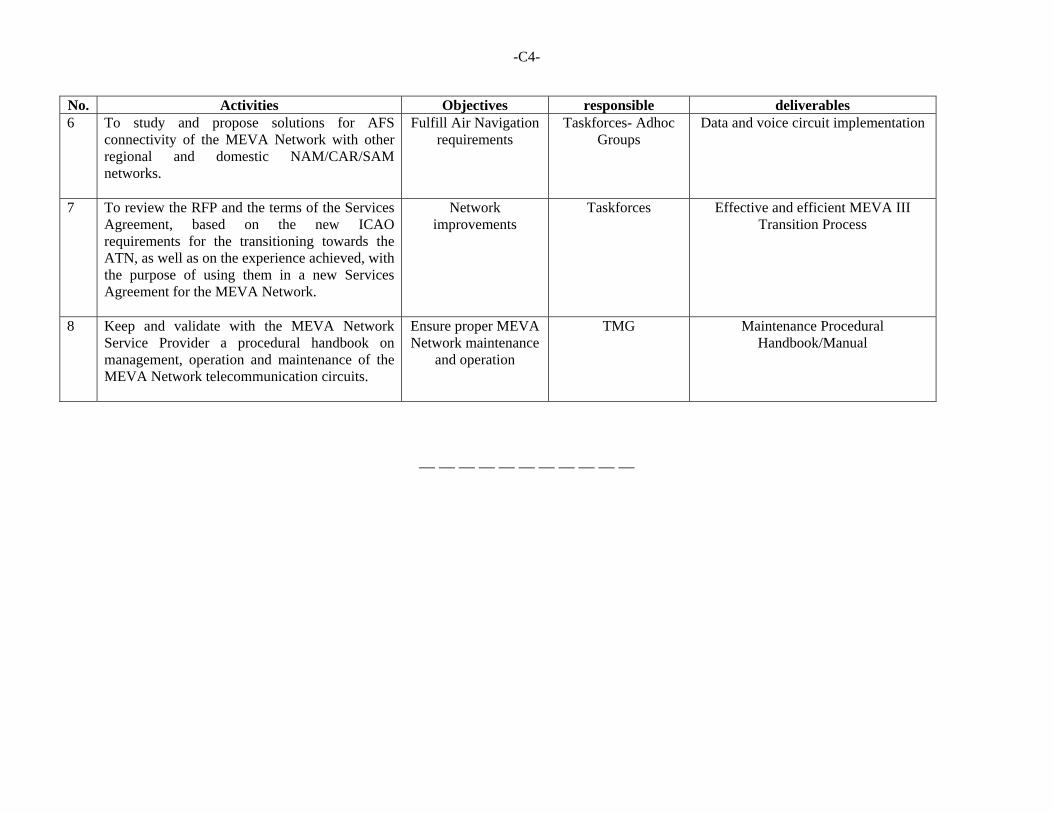
-C4-
No. Activities Objectives responsible deliverables 6 To study and propose solutions for AFS
connectivity of the MEVA Network with other regional and domestic NAM/CAR/SAM networks.
Fulfill Air Navigation requirements
Taskforces- Adhoc Groups
Data and voice circuit implementation
7 To review the RFP and the terms of the Services Agreement, based on the new ICAO requirements for the transitioning towards the ATN, as well as on the experience achieved, with the purpose of using them in a new Services Agreement for the MEVA Network.
Network improvements
Taskforces Effective and efficient MEVA III Transition Process
8 Keep and validate with the MEVA Network Service Provider a procedural handbook on management, operation and maintenance of the MEVA Network telecommunication circuits.
Ensure proper MEVA Network maintenance
and operation
TMG Maintenance Procedural Handbook/Manual
— — — — — — — — — — —
APPENDIX D TERMS OF REFERENCE
MEVA III NETWORK IMPLEMENTATION GO-TEAM
ICAO REGIONAL TECHNICAL COOPERATION PROJECT — “CAR REGION IMPLEMENTATION OF THE PERFORMANCE BASED AIR NAVIGATION SYSTEM ”
(RLA/09/801)
1. References The Go-Team consists of subject matter experts selected among Project Member States and led by the ICAO NACC Regional Office. The purpose is to provide States with assistance required for effective MEVA III Network implementation that is aligned with regional air navigation and safety priorities contained in the NAM/CAR Regional Performance Based Air Navigation Implementation Plan (RPBANIP) under the following sub-projects:
Sub-Project 1. Implement a CAR Region PBN Airspace Concept Sub-Project 2. Implement Regional Air Traffic Flow Management
(ATFM) Sub-Project 3. Implement Flexible Use Airspace (FUA) Sub-Project 4. Enhance ATS situational awareness and improve
operational efficiency of ATS Unit(s) Sub-Project 5. Enhance Aerodrome Operations Capacity and Efficiency Sub-Project 6. Improve Regional Safety Sub-Project 7. Improve Search and Rescue System
The Go-Team initiative was approved by the Third Steering Committee Meeting (SCM/3) held in Trinidad and Tobago in April 2014. The Go-Team will provide Project Member States with technical assistance to meet the regional goals as agreed in the Port-of-Spain Declaration through the following:
Development of MEVA III Network implementation gap analysis Assistance to [State] with development of an action plan for effective
MEVA III Network implementation Ensure that the implementation of the MEVA III node in [State] is coherent
and compatible with the whole Network performance and implementation Review that Factory Acceptance Tests (FATs) and Site Survey results are
properly consider in the Site Acceptance Tests (SATs) and reflected as improvements to the MEVA III node performance
Verify that planned circuits and services are implemented Validate that the [State] MEVA III node configuration is properly
implemented and operating Review that as-built diagrams and other related documents are considered
in the SAT Participate with [State] to technically assist and support the SAT
-D2-
2. Composition of the MEVA III Network Project Go-Team for [State]
The Go-Team will be led by an ICAO NACC Regional Officer The Go-Team will be composed of subject matter experts from Project
Member States selected by the ICAO NACC Regional Office The Go-Team mission cost will be covered by the Regional Project Other Project Member States could send additional specialists as observers,
as long as all travel and daily subsistence allowance (DSA) costs are covered by such State, and upon [Receiving State] approval
The selected Go-Team experts shall comply with the required background for the mission
Specialists shall agree and sign a confidentiality agreement regarding the information observed and discussed during and after the Go-Team mission
The mission duration will be (3) days, as determined by the ICAO NACC Regional Office
3. State Responsibilities
The State shall designate a point-of-contact for Go-Team coordination, as well as personnel in charge of MEVA III Network implementation
Provide the required information for the gap analysis development Facilitate access and necessary resources for the achievement of the Go-
Team mission objectives Develop and comply with the Action Plan in accordance with the MEVA
III Network implementation Go-Team recommendations 4. General Work Programme
On-site Activities: Initial meeting to present Go-Team mission objectives to the [State] Civil
Aviation Authority Assessment of information for MEVA III Network implementation in
[State], as appropriate Conduct other related activities for MEVA III Network implementation in
[State] Debriefing meeting to inform the [State] Civil Aviation Authority on the
Go-Team mission outcomes
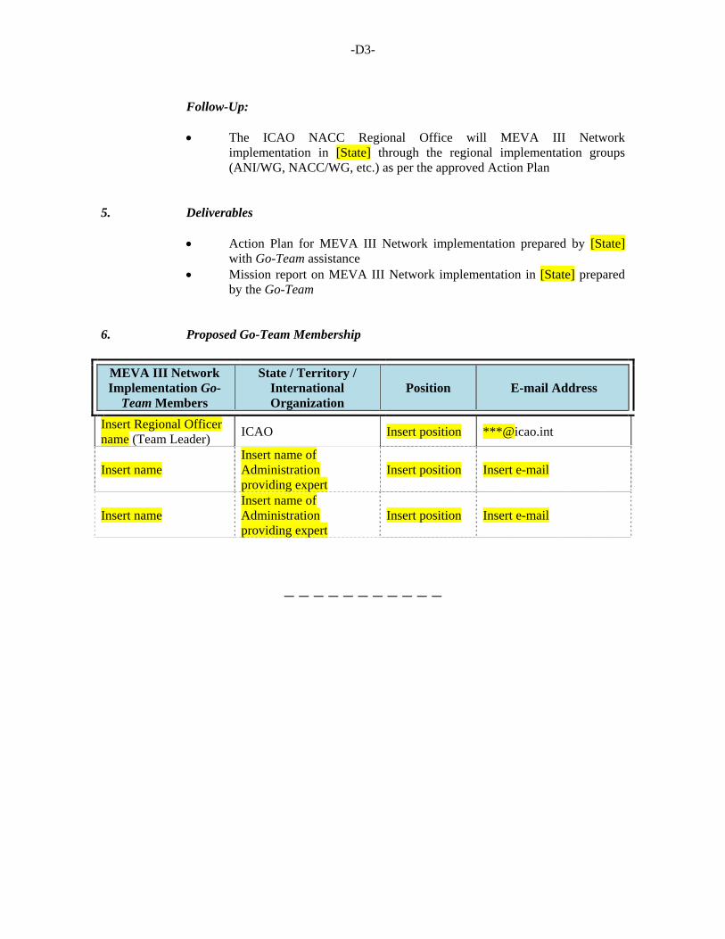
-D3-
Follow-Up: The ICAO NACC Regional Office will MEVA III Network
implementation in [State] through the regional implementation groups (ANI/WG, NACC/WG, etc.) as per the approved Action Plan
5. Deliverables
Action Plan for MEVA III Network implementation prepared by [State] with Go-Team assistance
Mission report on MEVA III Network implementation in [State] prepared by the Go-Team
6. Proposed Go-Team Membership
MEVA III Network Implementation Go-
Team Members
State / Territory / International Organization
Position E-mail Address
Insert Regional Officer name (Team Leader)
ICAO Insert position ***@icao.int
Insert name Insert name of Administration providing expert
Insert position Insert e-mail
Insert name Insert name of Administration providing expert
Insert position Insert e-mail
— — — — — — — — — — —
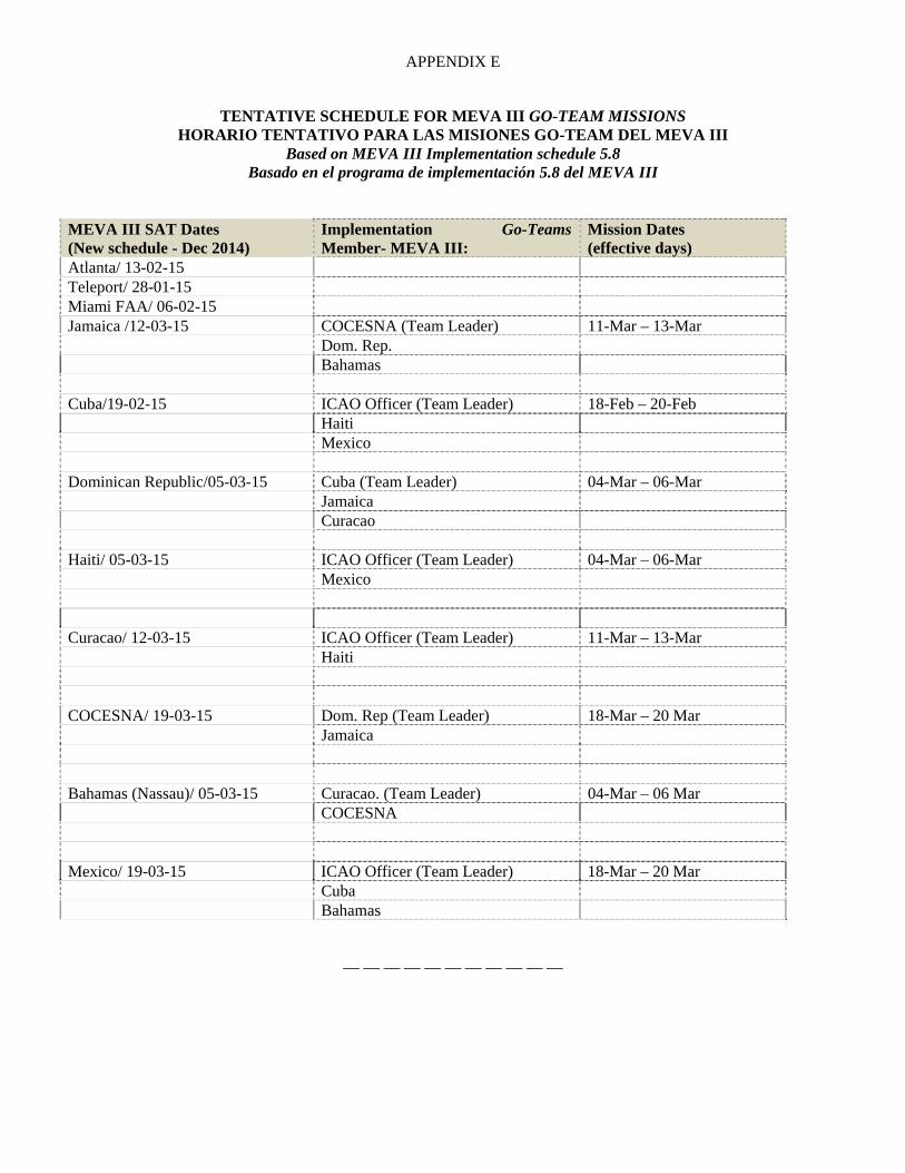
APPENDIX E
TENTATIVE SCHEDULE FOR MEVA III GO-TEAM MISSIONS HORARIO TENTATIVO PARA LAS MISIONES GO-TEAM DEL MEVA III
Based on MEVA III Implementation schedule 5.8 Basado en el programa de implementación 5.8 del MEVA III
MEVA III SAT Dates (New schedule - Dec 2014)
Implementation Go-Teams Member- MEVA III:
Mission Dates (effective days)
Atlanta/ 13-02-15 Teleport/ 28-01-15 Miami FAA/ 06-02-15 Jamaica /12-03-15 COCESNA (Team Leader) 11-Mar – 13-Mar Dom. Rep. Bahamas Cuba/19-02-15 ICAO Officer (Team Leader) 18-Feb – 20-Feb Haiti Mexico Dominican Republic/05-03-15 Cuba (Team Leader) 04-Mar – 06-Mar Jamaica Curacao Haiti/ 05-03-15 ICAO Officer (Team Leader) 04-Mar – 06-Mar Mexico Curacao/ 12-03-15 ICAO Officer (Team Leader) 11-Mar – 13-Mar Haiti COCESNA/ 19-03-15 Dom. Rep (Team Leader) 18-Mar – 20 Mar Jamaica Bahamas (Nassau)/ 05-03-15 Curacao. (Team Leader) 04-Mar – 06 Mar COCESNA Mexico/ 19-03-15 ICAO Officer (Team Leader) 18-Mar – 20 Mar Cuba Bahamas
— — — — — — — — — — —

APPENDIX F
MEVA TECHNICAL MANAGEMENT GROUP (TMG) MEETING ROTATIONAL SCHEDULE
a) The following meeting rotational schedule was developed and approved by the MEVA Members
during the MEVA TMG/29 Meeting with conclusion MEVA TMG/29/19; b) the participation of ICAO is to be funded by the hosting MEVA member. c) any other MEVA Member and/or MEVA III Service Provider normally invited to participate in
the MEVA TMG meetings may at any time offer to host a meeting; d) should a MEVA Member be unable to host a particular TMG meeting as per the schedule, it may
exchange positions with another MEVA Member through bilateral discussions and the ICAO NACC Regional Office should be informed of the change at the latest six months before the convening of the meeting;
e) should a MEVA Member be unable to host a particular TMG meeting as per the schedule and not
have exchanged positions in the programme with another MEVA Member, the ICAO NACC Regional Office should be advised at least six months before the convening of the meeting, where upon the next State on the list should take on the responsibility of hosting the meeting; and
f) Meeting Host Rotational schedule:
YEAR STATES OR GROUP OF TERRITORIES
2014 MEVA III Service Provider (Miami, United States - MEVA TMG/28)
2014 ICAO NACC Office (Mexico City, Mexico - MEVA TMG/29)
2015 Aruba (Oranjestad- MEVA TMG/30)
2016 Jamaica ( MEVA TMG/31)
2017 Cuba ( MEVA TMG/32)
2018 Curacao ( MEVA TMG/33)
2019 United States ( MEVA TMG/34)
— END —