international journal of research in social sciences
TRANSCRIPT

80
Volume: 11, Issue: 3, July-September 2021
INTERNATIONAL JOURNAL OF RESEARCH IN SOCIAL SCIENCES AND HUMANITIES
INTERNATIONAL JOURNAL OF RESEARCH IN SOCIAL SCIENCES &
HUMANITIES
An International Open-Access Peer Reviewed Referred Journal
Impact Factor: 8.909 E-ISSN : 2249 – 4642 P-ISSN: 2454 - 4671
*Ass lecture Hind Fadhil Ibrahim Al – Jubouri,**Lecture Firas .S. Raheem,
**Prof. Dr. Osama. K. Abdulridah, **Prof. Dr. Ali. A. Kazem *Al-Janaeen Primary Mixed School, **Education College Ibn Rushd for Humanities, Iraq
DOI: http://doi.org/10.37648/ijrssh.v11i03.005
Paper Received:
20th May, 2021
Paper Accepted:
10th July, 2021
Paper Received After Correction:
10th July, 2021
Paper Published:
10th July, 2021
How to cite the article: Hind Fadhil Ibrahim Al-Jubouri, Firas S Raheem, Prof Dr
Osama K Abdulridah, Prof Dr Ali A Kazem, Cartographic Analysis of the
Geomorphological Hazards of the Eastern Part of Sheikh Saad Sub-District by Using
GIS, July-September 2021 Vol 11, Issue 3; 80-92 DOI:
http://doi.org/10.37648/ijrssh.v11i03.005
,
I
RJAY, October: 2020 Vol
-
3, Issue
81
Volume: 11, Issue: 3, July-September 2021
INTERNATIONAL JOURNAL OF RESEARCH IN SOCIAL SCIENCES AND HUMANITIES
ABSTRACT
Geographical information systems are the latest applied computer technologies that
contribute to supporting contemporary geographical studies through the possibility of
working on preparing a database of geographical phenomena and modeling them in a digital
form by providing automated methods and a set of systems and programs for managing and
processing data with spatial and non-spatial reference, which is one of the important
functions in geographic information systems And the base on which it depends to reach the
optimal decisions to reveal the spatial relationships and correlations between geographical
phenomena and with high efficiency, to become the contemporary method in the method of
processing and spatial analysis of geographical information instead of the old traditional
methods of geographical analysis, and the system also allowed the geographical area to enter
into the era of modern technologies to evaluate phenomena. Geographical forecasting.
The research materials and methods are determined by adopting topographical and geological
maps, land-sat satellite visuals, and DEM data to form the search database, and based on the
GIS program (Arc Map 9.3) and the (Global Mepper 11) program and the extensions of the
(Arc Map 9.3) program, which are (Spatial Analysis) And the three-dimensional analysis (3D
analysis), and the outputs are the final process through which the results of the research
emerge.
These outputs show the type of information that will be processed and presented in the form
of three-dimensional maps and shapes, studying the most important causes of
geomorphological risks for the study area, and developing solutions and treatments through
the conclusions and recommendations of the research.

82
Volume: 11, Issue: 3, July-September 2021
INTERNATIONAL JOURNAL OF RESEARCH IN SOCIAL SCIENCES AND HUMANITIES
INTRODUCTION
Given the great importance occupied by
rivers, this requires tracking the natural
changes that occur in river basins, river
channels and the lands adjacent to them,
and observing the change in the
relationship between the elements of the
geomorphological environment (shape,
factor, process, surface materials) and the
degree of interaction between them during
short or long periods, which requires
Analyzing historical data and evidence to
determine the causes and extent of change
and to limit the human role in its
occurrence.
The soil of the shoulders of rivers and their
extensions from the soils of the banks, the
tongues and the rivers are of the soils of
the first category from the agricultural
point of view, due to the availability of
agricultural potentials in them and their
suitability for the growth of most crops.
Sheikh Saad and Ali Al-Gharbi, which
sparked the researcher's scientific curiosity
to study it and clarify its merits.
RESEARCH PROBLEMS AND
HYPOTHESES
The research problem centers on the
question of whether there is a defect or
ambiguity in the nature of the reasons and
the geographical factors that led to the
geomorphological risks in the Sheikh Saad
area.
Then the banks of the Tigris River were
salinized in the study area, the researchers
assume that there are natural and human
geographical factors and processes that
contributed to these risks in the study area.
Research Goal and Importance
The research aims to shed light on an
important phenomenon affecting people's
lives and the shape of the earth, as well as
revealing the factors that led to the
occurrence of this phenomenon, and
determining the scope of this phenomenon
and the possibility of its expansion or
disappearance.
Search Limits
The spatial boundaries of the research are
represented in the astronomically confined
area between two latitudes 28 º 32 ¯ and
.34 32 (North and between longitudes 16
46 and 42 46) East, and this location
places it geographically to include the
course of the Tigris River between the city
center of Sheikh Saad district, the end of
the southern administrative borders of
Wasit Governorate from the north
And the center of the city of Ali Al-Gharbi
District, the beginning of the northern
administrative borders of Maysan
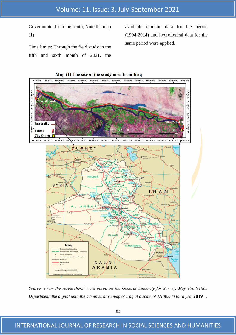
83
Volume: 11, Issue: 3, July-September 2021
INTERNATIONAL JOURNAL OF RESEARCH IN SOCIAL SCIENCES AND HUMANITIES
Governorate, from the south, Note the map
(1)
Time limits: Through the field study in the
fifth and sixth month of 2021, the
available climatic data for the period
(1994-2014) and hydrological data for the
same period were applied.
Source: From the researchers’ work based on the General Authority for Survey, Map Production
Department, the digital unit, the administrative map of Iraq at a scale of 1/100,000 for a year 2019 .
84
Volume: 11, Issue: 3, July-September 2021
INTERNATIONAL JOURNAL OF RESEARCH IN SOCIAL SCIENCES AND HUMANITIES
Some of the physical geographic
characteristics of the study area
FIRST: GEOLOGY:
Geomorphology is interested in studying
the geological formation from several
aspects, the most important of which is its
use in extracting scientific explanations for
the types of terrain and geomorphological
forms in the region. And what this
formation has on the quality of soil,
surface and ground water and the direction
of their flow.
The study area is located within the
sedimentary plain, which is completely
covered by the sediments of the
Quaternary period, which is an ancient
wind, silt, river and marine sediments.
What is not clear, due to repeated erosion
and sedimentation processes and the lack
or absence of fossils?
Geological formations have been confined
On river sediments, it can be dealt with in
two main topics as follows:-
1- Pleistocene alluvial deposits:
These deposits are represented in the first
era of the Quaternary period (Pleistocene),
which began before (8.1) million years
ago, and the upper limit of these deposits
is (15) p below the surface of the earth and
its thickness reaches (174) m. It consists of
deposits of sand, silt and clay. They
overlap with each other in the layers, and
the sand is more dominant than others, and
the thickness of the layers ranges from
centimeters to some meters, 3 and
accordingly it can be said that these
sediments do not appear in the study area
except in the regions.
2- Holocene sediments:
These deposits are represented in the
second era of the Quaternary time
(Holocene), which began 10 thousand
years ago
It lays several types of sediments, the most
important of which is the sediments of the
floodplain that occupy the entire study
area. It was deposited by the waters of the
Tigris River, whose thickness is (10-15)
m, and consists mostly of sand, silt and
clay.1
The folds in the basin spread in a north-
east-southwest direction and sometimes
from north to south. These folds are
characterized by their convergence and
asymmetry at both ends and there are
many cracks, which often take directions
similar to the directions of the folds with a
large spread of breaks and cracks on the
surfaces of rocks.2
Barazi, Geography of Iraq, -Khattab and Nuri al - 1
Baghdad Press, 1979, p. 83. Sameh Jazmati and Sami Makdisi, Geographical - 2
Information Systems, Arab Orient House, Lebanon, 2005, p. 151.

85
Volume: 11, Issue: 3, July-September 2021
INTERNATIONAL JOURNAL OF RESEARCH IN SOCIAL SCIENCES AND HUMANITIES
These deformations occurred as a result of
the torsion that affected the region, and
these deformations represented by cracks,
joints and fissures are a weakening factor
for the rocks and activate the chemical or
mechanical weathering process.
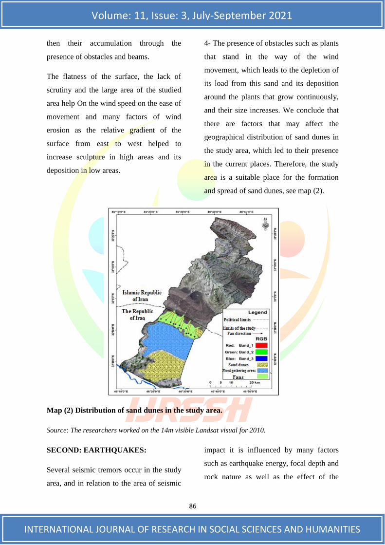
Analysis of the most important
geomorphological risks First - spatial
analysis of the distribution and shapes of
sand dunes in the study area and includes.3
Preparing the sand dunes and identifying
their locations and the extension of the
sand dune belts prevalent in Iraq and the
study area and studying the shapes of the
sand dunes scattered in the study area as
well as the spatial analysis of the
distribution of the sand dunes prevalent in
them, and the areas of their presence at the
level of the study for determining their
spread areas, and making measurements
from satellite images to know Its height,
spatial extension and directionality were
also used in determining the areas affected
by this phenomenon.4
Factors affecting the formation of sand
dunes.
Jabbab River -Lami, Al-Talal Mariwish Gari Al - 3
Basin in Iraq (its definition, shape and characteristics) Master’s Thesis (AS), College of Arts, University of Baghdad, 1992, pp. 241-242.
Jubouri, -di Hamad Muhammad alHa-Abd al - 4
Problems of calculating regression, slope and body in GIS software for a molar region of Bashiqa,
diploma thesis of the Department of Geography, College of Education, University of Mosul, 2016, p.
12
1- The wind.
2- Availability of sand sources.
3- Topographical characteristics.
Sand dunes in the study area: The sand
dunes in the study area are in several
forms:5
Cress centie dunes or Barchans
magnitude dunes
cross dunes
shrub - coppice Dune
Dome dunes
Sandy hills or mounds
The most important factors affecting the
distribution of sand dunes in the study area
1- The regularity and dominance of
northwesterly winds, accompanied
sometimes by southeasterly winds Which
descended as a clear retaliation in the
nature of the extension of the sand dunes
in the northern study area West - southeast.
2- The nature of the geological formation
of the study area and the presence of the
first formations on the sand from the
Miocene era to the Pliocene era. These
formations are a permanent source of
nutrition for the sand in the study area
through weathering and transportation and
Sahaf, -nd Mahdi Ali AlNafas a-Adnan Baqir Al - 5
Geomorphology, Dar Al-Kutub for Printing and Publishing, University of Baghdad, 1989, p. 240-
241.
86
Volume: 11, Issue: 3, July-September 2021
INTERNATIONAL JOURNAL OF RESEARCH IN SOCIAL SCIENCES AND HUMANITIES
then their accumulation through the
presence of obstacles and beams.
The flatness of the surface, the lack of
scrutiny and the large area of the studied
area help On the wind speed on the ease of
movement and many factors of wind
erosion as the relative gradient of the
surface from east to west helped to
increase sculpture in high areas and its
deposition in low areas.
4- The presence of obstacles such as plants
that stand in the way of the wind
movement, which leads to the depletion of
its load from this sand and its deposition
around the plants that grow continuously,
and their size increases. We conclude that
there are factors that may affect the
geographical distribution of sand dunes in
the study area, which led to their presence
in the current places. Therefore, the study
area is a suitable place for the formation
and spread of sand dunes, see map (2).
Map (2) Distribution of sand dunes in the study area.
Source: The researchers worked on the 14m visible Landsat visual for 2010.
SECOND: EARTHQUAKES:
Several seismic tremors occur in the study
area, and in relation to the area of seismic
impact it is influenced by many factors
such as earthquake energy, focal depth and
rock nature as well as the effect of the
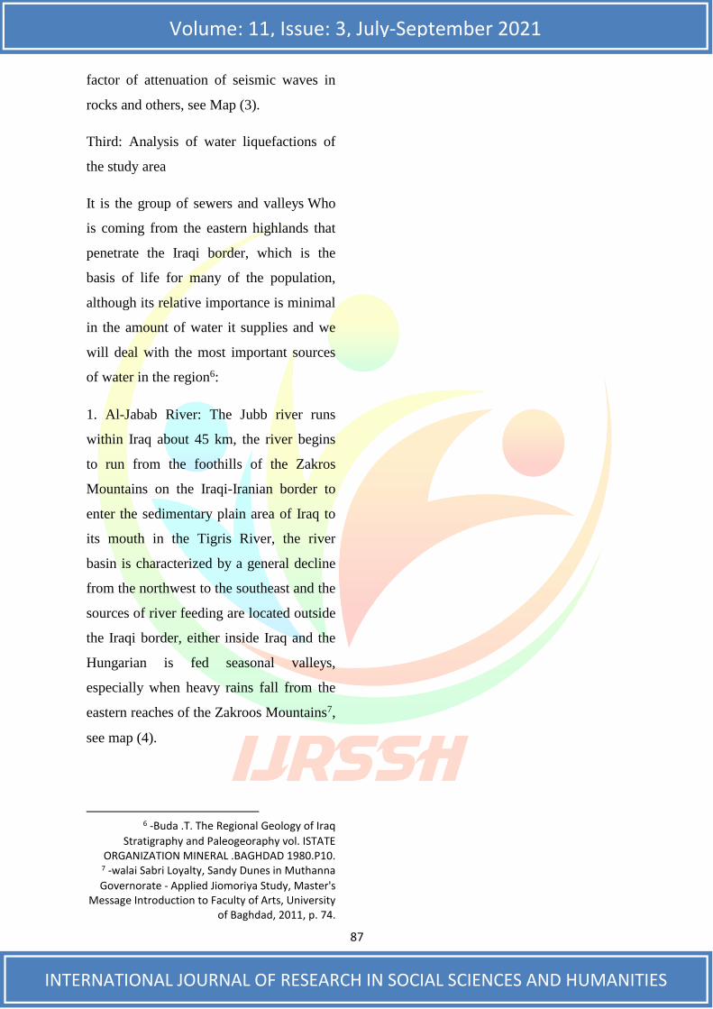
87
Volume: 11, Issue: 3, July-September 2021
INTERNATIONAL JOURNAL OF RESEARCH IN SOCIAL SCIENCES AND HUMANITIES
factor of attenuation of seismic waves in
rocks and others, see Map (3).
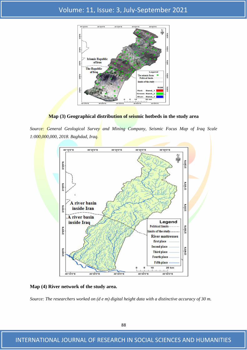
Third: Analysis of water liquefactions of
the study area
It is the group of sewers and valleys Who
is coming from the eastern highlands that
penetrate the Iraqi border, which is the
basis of life for many of the population,
although its relative importance is minimal
in the amount of water it supplies and we
will deal with the most important sources
of water in the region6:
1. Al-Jabab River: The Jubb river runs
within Iraq about 45 km, the river begins
to run from the foothills of the Zakros
Mountains on the Iraqi-Iranian border to
enter the sedimentary plain area of Iraq to
its mouth in the Tigris River, the river
basin is characterized by a general decline
from the northwest to the southeast and the
sources of river feeding are located outside
the Iraqi border, either inside Iraq and the
Hungarian is fed seasonal valleys,
especially when heavy rains fall from the
eastern reaches of the Zakroos Mountains7,
see map (4).
Buda .T. The Regional Geology of Iraq - 6
Stratigraphy and Paleogeoraphy vol. ISTATE ORGANIZATION MINERAL .BAGHDAD 1980.P10.
bri Loyalty, Sandy Dunes in Muthanna Sa walai- 7
Governorate - Applied Jiomoriya Study, Master's Message Introduction to Faculty of Arts, University
of Baghdad, 2011, p. 74.
88
Volume: 11, Issue: 3, July-September 2021
INTERNATIONAL JOURNAL OF RESEARCH IN SOCIAL SCIENCES AND HUMANITIES
Map (3) Geographical distribution of seismic hotbeds in the study area
Source: General Geological Survey and Mining Company, Seismic Focus Map of Iraq Scale
1:000,000,000, 2018. Baghdad, Iraq.
Map (4) River network of the study area.
Source: The researchers worked on (d e m) digital height data with a distinctive accuracy of 30 m.
89
Volume: 11, Issue: 3, July-September 2021
INTERNATIONAL JOURNAL OF RESEARCH IN SOCIAL SCIENCES AND HUMANITIES
The number of river mattresses for the al-
Jabab colleges was 5 river levels. The area
of the Jabab River basin is the largest area
on the Iranian side of the Iraqi side,
originating from the drainage basins in
Iran from a very severely cut and damaged
area.
2. al-Maleh Valley: It originates from
Iranian territory towards Iraq and enters a
limited area within, the mountain area is a
small fan component connected to the
Shihabi River fan.
3. The old Shihabi Valley: it is part of the
Shihabi River other than the Shihabi River
in the area, Shihabi fan ends the old stream
in the low-lying area of the torrent pool
area in the part of Eastern study area.
4. Groundwater: Groundwater is of great
importance to the life and cultivation of
the population in dry and dry areas where
surface water sources are not available,
and climate, topography and rock quality
factors control the size, quality and
distribution of groundwater from region to
region8.
The most important problems caused by
water deposits
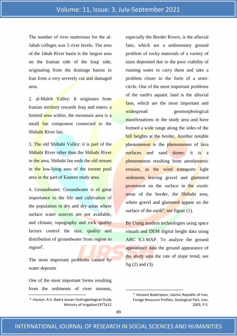
One of the most important forms resulting
from the sediments of river streams,
Hassan. A.h. Badra Jassan Hydrogeological Study - 8
Ministry of Irrigation1977p12
especially the Border Rivers, is the alluvial
fans, which are a sedimentary ground
problem of rocky materials of a variety of
sizes deposited due to the poor viability of
running water to carry them and take a
problem closer to the form of a semi-
circle. One of the most important problems
of the earth's aquatic land is the alluvial
fans, which are the most important and
widespread geomorphological
manifestations in the study area and have
formed a wide range along the sides of the
hill heights at the border, Another notable
phenomenon is the phenomenon of lava
surfaces and sand dunes: it is a
phenomenon resulting from aerodynamic
erosion, as the wind transports light
sediments leaving gravel and glammed
prominent on the surface in the exotic
areas of the border, the Shihabi area,
where gravel and glammed appear on the
surface of the earth9, see figure (1).
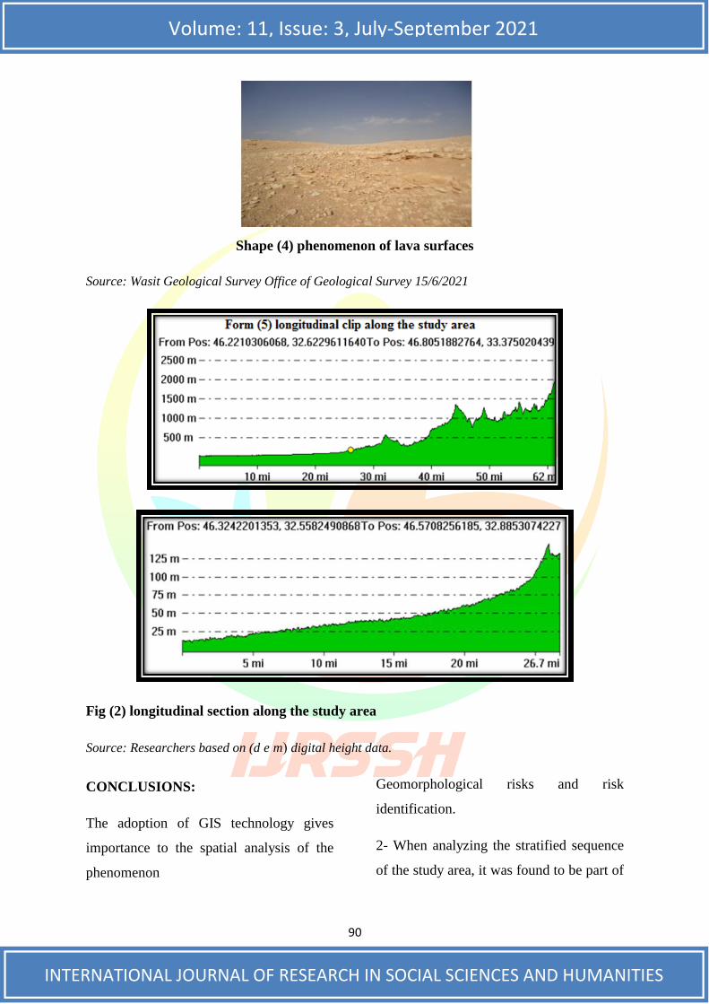
By Using modern technologies using space
visuals and DEM digital height data using
ARC 9.3 MAP. To analyze the ground
appearance data the ground appearance of
the study area the rate of slope trend, see
fig (2) and (3).
deripour, Islamic Republic of Iran, Hossein Ba- 9
Forage Resource Profiles, Geological Part, Iran, 2005, P.5.
90
Volume: 11, Issue: 3, July-September 2021
INTERNATIONAL JOURNAL OF RESEARCH IN SOCIAL SCIENCES AND HUMANITIES
Shape (4) phenomenon of lava surfaces
Source: Wasit Geological Survey Office of Geological Survey 15/6/2021
Fig (2) longitudinal section along the study area
Source: Researchers based on (d e m ( digital height data.
CONCLUSIONS:
The adoption of GIS technology gives
importance to the spatial analysis of the
phenomenon
Geomorphological risks and risk
identification.
2- When analyzing the stratified sequence
of the study area, it was found to be part of
91
Volume: 11, Issue: 3, July-September 2021
INTERNATIONAL JOURNAL OF RESEARCH IN SOCIAL SCIENCES AND HUMANITIES
the class sequence that appears in all parts
of the Earth's surface.
3- Sand dunes are a common phenomenon
in the study area and have a large impact
on agricultural areas and villages through
the dust rising from the dunes and
crawling on the nearby territory.
4- The diversity of forms resulting from
the sand dunes in the study area.
5- Climate phenomena play a role in
controlling the movement of sand dunes in
the study area. The frequency of
earthquakes in the study area and to a
varying degree, and the water flows in the
study area emerged through the
metorization of the Shihabi River on the
area and the frequency of the phenomenon
of floods on the study area10.
6- Alluvial fans and helicopter buckets in
the study area are water liquefactions, rock
dredging, sand and gravel from inside Iran
to Iraq.
7- Diversity in the height of the study area
between the drainage basins of river
streams in Iraq and Iran, where basins in
Iran are characterized by the fact that they
take place in rugged areas and mooring
lands either in Iraq characterized by the
land characterized by the simplicity or
gradual decline of the surface of the earth.
Tibor Boday, and Saad Z Jassim, The Regional - 10
Gaology of Iraq Volumel Baghdad. 1987.p18.
8- In most of the study area, reliance on
well water, which is characterized by the
fact that most of them are unfit for human
use.
9- The sovereignty of the phenomenon of
overgrazing in the study area11.
RECOMMENDATIONS:
1- Establish research centers to study and
identify geomorphological risk areas in
order to develop studies to reduce their
impact.
2- Installing sand dunes in the study area
to reduce their risks to the area.
3- Construction of dams and dirt payments
to reduce floods from the Iranian
highlands. 4- The establishment of
earthquake registration centers in the study
area.
4- Adopting modern techniques to monitor
environmental changes in the region and
predict geomorphological hazards.
5- The establishment of climatic plants in
the study area to monitor climatic
phenomena. Use of floodwaters in the
rainy season and use in groundwater
feeding and use in agriculture.
Philip Lake, Physical Geography, Thtrdedition - 11
Cambridge at the Universusty, Press, 1955, P. (367)
92
Volume: 11, Issue: 3, July-September 2021
INTERNATIONAL JOURNAL OF RESEARCH IN SOCIAL SCIENCES AND HUMANITIES
REFERENCES
1. Speech and Nuri Al-Barazi, Geography of Iraq, Baghdad Press, 1979.
2. Sameh Jazzati, Sami Makdessi, Geographic Information Systems, Arab Orient House,
Lebanon, 2005.
3. Talal Marouche Jari Lami, The Dock of the Jabor River in Iraq (identified, shape and
characteristics) Master's Message (PM) Faculty of Arts, University of Baghdad, 1992.
4. Abdul Hadi Hamad Mohammed Al-Jubouri, regression, tendency and bodybuilding
problems in geographical information systems for hymen, Diploma, Faculty of
Education, University of Mosul.
5. Adnan Baqir al-Nafas and Mahdi Ali Al-Sahaf, Jiu Morphology, House of Printing
and Publishing, University of Baghdad, 1989.
6. walai Sabri Loyalty, Sandy Dunes in Muthanna Governorate - Applied Jiomoriya
Study, Master's Message Introduction to Faculty of Arts, University of Baghdad,
2011.
7. Buda .T. The Regional Geology of Iraq Stratigraphy and Paleogeoraphy vol. ISTATE
ORGANIZATION MINERAL .BAGHDAD 1980.
8. Hassan. A.h. Badra Jassan Hydrogeological Study Ministry of Irrigation1977.
9. Hossein Baderipour, Islamic Republic of Iran, Forage Resource Profiles, Geological
Part, Iran, 2005.
10. Philip Lake, Physical Geography, Thtrdedition Cambridge at the Universusty, Press,
1955.
11. Tibor Boday, and Saad Z Jassim, The Regional Gaology of Iraq Volumel Baghdad.
1987.