internet and spatial data infrastructure - towards a
TRANSCRIPT

Created by Neevia Personal Converter trial version http://www.neevia.com
1
Internet and Spatial Data Infrastructure - Towards a Spatial Society
Vlado CETL, Miodrag ROI�, Hrvoje MATIJEVI�
Abstract. A society in lack of information is limited in successful social and economic development. The fact that more than 80% of information contains some spatial component results in a need for building of an efficient spatial information managing system. Many countries in the world have acknowledged this problem and induced the establishment of spatial data infrastructure (SDI) in which the Internet has had a crucial role. The SDI is a significant advancement in data delivery and standardization using the Internet and World Wide Web (WWW) to deliver spatial data to users. The process of establishing of spatial data infrastructure has originally started in United States by President Clinton's Executive Order 12906 in April 1994. This Order has promoted building of SDI in USA, Australia, Canada, in Western European countries, and in a last time in transition countries in our neighborhood such as Slovenia and Hungary. Development of SDI in mentioned countries were different and also there were different initiatives for starting of this process. An overview of SDI establishment in mentioned countries and the need for SDI establishing in Croatia are presented in this paper.
Key words: Internet, WWW, Spatial Data Infrastructure, development.
1. Introduction
Information and communication technologies change the world that we live in. Their influence is not known completely but it can be claimed with certainty that they open the way towards a society of information and knowledge (Vlada RH 2001).
Development and application of information and communication technologies resulted in the building of computer networks, their connecting and creation of world global net – Internet. Up-to-date experience in using the Internet have shown that the further course of connecting to the Internet is going to change the way of human living in near future. According to some evaluations, today's amount of information will in fifty years time make only 5% of all accessible information.
A society "hungry" for information is limited in its development. As 80% of all accessible information contains some spatial component (Grant 1999), what follows is that a society, which does not dispose of and manage spatial data, lacks possibility of overall social and economic development. Without spatial data it is impossible to manage the space efficiently.
In the last two-decade the amount of spatial data that has been collected in digital form has increased dramatically due to the rapid development of spatial data capture technologies. The advancement in technologies such as the Global Positioning System (GPS), satellite imaging and total stations have all made the capture of digital spatial data a relatively quick and easy process (Phillips et al. 1999).
Vlado Cetl, dipl. ing., prof. dr. sc. Miodrag Roi�, Hrvoje Matijevi�, dipl. ing., University of Zagreb, Faculty of Geodesy, Institute of Engineering Geodesy and Spatial Information Management, Ka�i�eva 26, Zagreb, e-mail: [email protected], [email protected], [email protected].
Created by Neevia Personal Converter trial version http://www.neevia.com
Created by Neevia Personal Converter trial version http://www.neevia.com
Created by Neevia Personal Converter trial version http://www.neevia.com
2
Geographic information systems (GIS) allow users to integrate, analyze, and manage information about locations in ways never before possible. Improvements in software, increased storage capacity, and plummeting hardware costs have put spatial data and associated technologies on desktops everywhere.
Problems that emerge in relation to spatial data are different and can be seen mainly in their mutual connection, distribution and redundancy. For some part of space, for example some land parcel there can exist different organizations and companies that collect the same spatial data. Removal of that redundancy in data and making existing data available for insight as well as making their distribution possible for interested users enables attaining huge savings for the state and society. A big number of countries all over the world realized that need which has resulted in the beginning of building a spatial data infrastructure.
2. Spatial Data Infrastructure
The term “Spatial Data Infrastructure” (SDI) is often used to denote the relevant base collection of technologies, policies and institutional arrangements that facilitate the availability of and access to spatial data. The SDI provides a basis for spatial data discovery, evaluation and application for users and providers within all levels of government, the commercial sector, the non-profit sector, academia and by citizens in general (Nebert 2001).
An SDI must be more than a single data set or database; an SDI hosts geographic data and attributes, sufficient documentation (metadata), a means to discover, visualize, and evaluate the data (catalogueues and Web mapping), and some method to provide access to the geographic data.
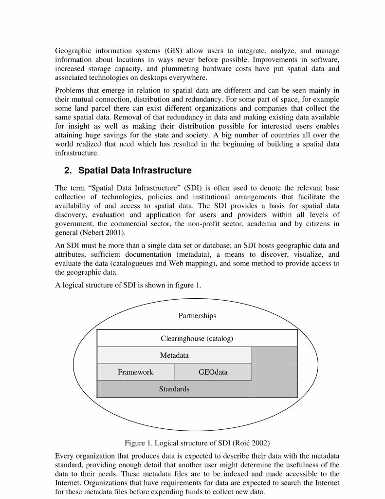
A logical structure of SDI is shown in figure 1.
Partnerships
Clearinghouse (catalog)
Metadata
Framework GEOdata
Standards
Figure 1. Logical structure of SDI (Roi� 2002)
Every organization that produces data is expected to describe their data with the metadata standard, providing enough detail that another user might determine the usefulness of the data to their needs. These metadata files are to be indexed and made accessible to the Internet. Organizations that have requirements for data are expected to search the Internet for these metadata files before expending funds to collect new data.
Created by Neevia Personal Converter trial version http://www.neevia.comCreated by Neevia Personal Converter trial version http://www.neevia.com

Created by Neevia Personal Converter trial version http://www.neevia.com
Created by Neevia Personal Converter trial version http://www.neevia.comCreated by Neevia Personal Converter trial version http://www.neevia.com
3
A user interested in locating spatial information uses a search user interface on WWW with web browser, fills out a search form, specifying queries for data with certain properties. The search request is passed to the Catalog Gateway and poses the query of one or more registered catalog servers. Each catalog server manages a collection of metadata entries. Within the metadata entries there are instructions on how to access the spatial data being described. Figure 2 shows the basic interactions of various individuals or organizations involved in the advertising and discovery of spatial data.
user
User Interface uses
Catalog Gateway
Directory of Servers
Catalog Server(s)
Metadata Spatial Data
that posts a query to
searches
searches multiple
deliver entries of
has reference to
Figure 2. Interaction diagram showing basic usage of distributed catalog services and related SDI elements from a user point of view. (Nebert 2001)
Types of spatial data vary from country to country. In basic sets of spatial data important for building of SDI the following can be included.
• digital orthoimagery, • geodetic control, • elevation, • transportation, • hydrology, • administrative boundaries, • cadastral or ownership information, • …
3. Development of Spatial Data Infrastructure
By the early 1990's, the concept of SDI development was being proposed in support of accelerating geographic information exchange standards efforts, selected national mapping programs and the establishment of nation-wide spatial information networks in the United States, the United Kingdom, Canada and the European Community (Coleman and McLaughlin 1997).
Created by Neevia Personal Converter trial version http://www.neevia.comCreated by Neevia Personal Converter trial version http://www.neevia.comCreated by Neevia Personal Converter trial version http://www.neevia.com

Created by Neevia Personal Converter trial version http://www.neevia.com
Created by Neevia Personal Converter trial version http://www.neevia.comCreated by Neevia Personal Converter trial version http://www.neevia.comCreated by Neevia Personal Converter trial version http://www.neevia.com
4
3.1 USA
A critical national need for improved means for finding and sharing geographic data was recognized by President Clinton in Executive Order 12906 of April 1994. This document called for the establishment of a coordinated National Spatial Data Infrastructure (NSDI) "to support public and private sector applications of geospatial data in such areas as transportation, community development, agriculture, emergency response, environmental management and information technology." The NSDI was seen as part of the evolving National Information Infrastructure that would provide citizen access to essential government information and thus strengthen the democratic process (FGDC 1997).
In the USA Federal Geographic Data Committee (FGDC) coordinates the development of the NSDI. The 17 federal agencies that make up the FGDC are developing the NSDI in cooperation with organizations from state, local and tribal governments, the academic community, and the private sector.
The Geospatial Data Clearinghouse in the USA is a collection of over 250 spatial data servers, that have digital geographic data primarily for use in Geographic Information Systems (GIS), image processing systems, and other modeling software. These data collections can be searched through a single interface based on their descriptions, or metadata (Figure 3.)
Figure 3. Clearinghouse Interface
The SDI activities in the USA have been focused on encouraging communication among the diverse collectors and users of spatial data. Unlike many other nations, the various levels of government in the US function relatively independently and various incentives for cooperation must be identified.
Development of SDI in the USA and especially President Clinton's Executive Order induced the development of SDI all over the world.
Created by Neevia Personal Converter trial version http://www.neevia.comCreated by Neevia Personal Converter trial version http://www.neevia.comCreated by Neevia Personal Converter trial version http://www.neevia.comCreated by Neevia Personal Converter trial version http://www.neevia.com

Created by Neevia Personal Converter trial version http://www.neevia.com
Created by Neevia Personal Converter trial version http://www.neevia.comCreated by Neevia Personal Converter trial version http://www.neevia.comCreated by Neevia Personal Converter trial version http://www.neevia.comCreated by Neevia Personal Converter trial version http://www.neevia.com
5
3.2 Canada
The Canadian Geospatial Data Infrastructure (CGDI) is a distributed set of data, as well as services and applications that enable the sharing and use of geospatially referenced information. The CGDI is being developed by the Geoconnections program.
GeoConnections is a national partnership initiative working to build the Canadian Geospatial Data Infrastructure (CGDI), which will make Canada’s geospatial databases, tools and services readily accessible on-line (http://cgdi.gc.ca/).
Canada has developed CEONet (Canadian Earth Observation Network) technology. CEONet is a geospatial data clearinghouse, and is the prime access component of the Canadian Geospatial Data Infrastructure. It provides access to organisations, products and services from across Canada and around the world.
The Discovery Portal (Figure 4) is the prime discovery and access component of the CGDI. Tools and services are developed in close cooperation with CGDI Stakeholders: consumers, suppliers, developers and peers.
Figure 4. GeoConnections Discovery Portal
3.3 Australia and New Zeland
The concept of national infrastructures is not new in Australia and New Zealand. In both nations, the major road and telecommunications networks, and basic health and education facilities, have been funded by government to ensure that consistent infrastructure is developed in the national interest.
Commonwealth Spatial Data Committee (CSDC) and Australia New Zealand Information Council (ANZLIC) are promoting actively the concept of ASDI to provide fundamental data needed to support decision making. ANZLIC has developed a national spatial data infrastructure model that comprises four core components: institutional framework, technical standards, fundamental datasets and clearing house networks (ANZLIC 1996).
Created by Neevia Personal Converter trial version http://www.neevia.comCreated by Neevia Personal Converter trial version http://www.neevia.comCreated by Neevia Personal Converter trial version http://www.neevia.comCreated by Neevia Personal Converter trial version http://www.neevia.comCreated by Neevia Personal Converter trial version http://www.neevia.com
Created by Neevia Personal Converter trial version http://www.neevia.com
Created by Neevia Personal Converter trial version http://www.neevia.comCreated by Neevia Personal Converter trial version http://www.neevia.comCreated by Neevia Personal Converter trial version http://www.neevia.comCreated by Neevia Personal Converter trial version http://www.neevia.comCreated by Neevia Personal Converter trial version http://www.neevia.com
6
The institutional framework defines the policy and administrative arrangements for building, maintaining, accessing and applying the standards and datasets. The technical standards define the technical characteristics of the fundamental datasets. The fundamental datasets are produced within the institutional framework and fully comply with the technical standards. The clearinghouse network is the means by which the fundamental datasets are made accessible to the community, in accordance with policy determined within the institutional framework, and to the agreed technical standards.
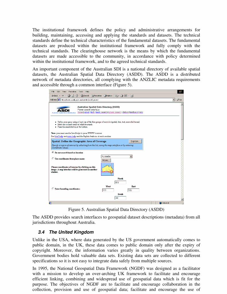
An important component of the Australian SDI is a national directory of available spatial datasets, the Australian Spatial Data Directory (ASDD). The ASDD is a distributed network of metadata directories, all complying with the ANZLIC metadata requirements and accessible through a common interface (Figure 5).
Figure 5. Australian Spatial Data Directory (ASDD)
The ASDD provides search interfaces to geospatial dataset descriptions (metadata) from all jurisdictions throughout Australia.
3.4 The United Kingdom
Unlike in the USA, where data generated by the US government automatically comes to public domain, in the UK, these data comes to public domain only after the expiry of copyright. Moreover, the information varies greatly in quality between organizations. Government bodies hold valuable data sets. Existing data sets are collected to different specifications so it is not easy to integrate data safely from multiple sources.
In 1995, the National Geospatial Data Framework (NGDF) was designed as a facilitator with a mission to develop an over-arching UK framework to facilitate and encourage efficient linking, combining and widespread use of geospatial data which is fit for the purpose. The objectives of NGDF are to facilitate and encourage collaboration in the collection, provision and use of geospatial data; facilitate and encourage the use of
Created by Neevia Personal Converter trial version http://www.neevia.comCreated by Neevia Personal Converter trial version http://www.neevia.comCreated by Neevia Personal Converter trial version http://www.neevia.comCreated by Neevia Personal Converter trial version http://www.neevia.comCreated by Neevia Personal Converter trial version http://www.neevia.comCreated by Neevia Personal Converter trial version http://www.neevia.com

Created by Neevia Personal Converter trial version http://www.neevia.com
Created by Neevia Personal Converter trial version http://www.neevia.comCreated by Neevia Personal Converter trial version http://www.neevia.comCreated by Neevia Personal Converter trial version http://www.neevia.comCreated by Neevia Personal Converter trial version http://www.neevia.comCreated by Neevia Personal Converter trial version http://www.neevia.comCreated by Neevia Personal Converter trial version http://www.neevia.com
7
standards and best practices in the collection, provision and use of geospatial data; and facilitate access to geospatial data.
A major NGDF project under way is the NGDF Metadata project, which will set up a directory service to bring together through the Internet those who are providers of geospatial data with the users of such data. The project and the service are seen as central to government's role in making geospatial information more widespread. The NGDF Metadata Service will be in near future up and running (www.ngdf.org.uk).
A second NGDF project is United Kingdom Standard Geographic Base (UKSGB) Internet based service. The UK Standard Geographic Base was initiated because many different users of geography called for standardization and a central source of information about geographic areas. The UKSGB provides: a standard infrastructure, supported by the National Geospatial Data Framework (NGDF), a published set of commonly used core spatial units and, an internet service, which describes these core spatial units and the associated geographic datasets (Figure 6).
Figure 6. United Kingdom Standard Geographic Base
3.5 Hungary
An action plan for a Hungarian Spatial Data Infrastructure and the National Information Strategy has been discussed by experts for the Government for several years. The Prime Minister’s Office in the Hungarian government has decided to pursue the formulation of an Information Society action plan and a National Spatial Data Strategy. The Resolution No. (13/1997. (X.15.) of the Governmental Commission for Informatics and Telecommunication prescribed the elaboration of a comprehensive National Spatial Data Strategy. According to the Resolution, the Secretary of Public Administration of the Prime Minister's Office was responsible for that, involving the corresponding ministers and leaders of national institutions. The deadline was June 30, 1998. (Kovács and Mihály 2001).
The reason for developing the National Spatial Data Strategy was, among others, that the gathering of mapping data is costly. Therefore the organizations that share similar
Created by Neevia Personal Converter trial version http://www.neevia.comCreated by Neevia Personal Converter trial version http://www.neevia.comCreated by Neevia Personal Converter trial version http://www.neevia.comCreated by Neevia Personal Converter trial version http://www.neevia.comCreated by Neevia Personal Converter trial version http://www.neevia.comCreated by Neevia Personal Converter trial version http://www.neevia.comCreated by Neevia Personal Converter trial version http://www.neevia.com

Created by Neevia Personal Converter trial version http://www.neevia.com
Created by Neevia Personal Converter trial version http://www.neevia.comCreated by Neevia Personal Converter trial version http://www.neevia.comCreated by Neevia Personal Converter trial version http://www.neevia.comCreated by Neevia Personal Converter trial version http://www.neevia.comCreated by Neevia Personal Converter trial version http://www.neevia.comCreated by Neevia Personal Converter trial version http://www.neevia.comCreated by Neevia Personal Converter trial version http://www.neevia.com
8
requirements for commonly needed data in the special discipline areas of surveying, photogrammetry, global positioning systems, and remote sensing have to develop plans that accommodate joint development and maintenance programs.
The elaboration of the Government's National Spatial Data Strategy collected the professionals in the interests of preparing documents for making government-level decision. The preliminary studies are already finished, the proposals for submission to the Government are partly ready. Various tasks are still waiting for solution:
• finalization of preparation of the NSDS • preparation of nation-wide technical plan of NSDI, data policy concept,
financing concept, institutional reorganization • recommendation on overall regulation providing the effective operation of
NSDI. Setting-up of NSDI in Hungary is in progress, as well as multiple projects which will contribute to the building of the NSDI. Hungary has a great help of the European Union in all that.
3.6 Slovenia
The Ministry for the Environment and Physical Planning has recognized that the real importance of the geo-referenced data and information is in their reliability, accessibility, content and value which they offer to the processes and users. Therefore, the Republic of Slovenia has within so called ‘Environmental Project’, financed by the International Bank for Reconstruction and Development (IBRD- The World Bank) launched also a project ONIX - Establishment of Slovenian geoinformation infrastructure (Režek 1998). Basic tasks to be realised within the ONIX project are:
• setting-up of Slovenian standards, above all for the field of data management, metadata system, distribution of data, and technical functioning of the entire system (communications, equipment);
• upgrading of GIC RS (Geoinformation Centre of the Republic of Slovenia) as the central location through which the distribution of spatial data from the managers of this data to the final users will be implemented. In practical terms this means the establishment of a computer system (server), a metadata standard for the description of data, a central metadata base, and a system of rapid communication between the GIC RS as the manager and the end-users of the system;
• establishment of group to promote the role of the geographical information infrastructure, increase interest and need for establishment and exchange of relevant data, ensure inter-ministerial co-operation and support for operation of some government and public services, and encourage private sector participation;
• establishment of a training system which will function according to internationally-recognized programs and assure preliminary, continuous and regular training of the managers and participants of the system, of data providers and users.
Works on establishing geoinformatics infrastructure in Slovenia resulted in the building of geoinformatics portal (Figure 7), and some further projects which are to enable electronically access to spatial data bases in Slovenia in near future are in progress. The geoinformatics portal enables access to central records of spatial data (metadata) where it is already possible to find information on big number of accessible spatial data in Slovenia.
Created by Neevia Personal Converter trial version http://www.neevia.comCreated by Neevia Personal Converter trial version http://www.neevia.comCreated by Neevia Personal Converter trial version http://www.neevia.comCreated by Neevia Personal Converter trial version http://www.neevia.comCreated by Neevia Personal Converter trial version http://www.neevia.comCreated by Neevia Personal Converter trial version http://www.neevia.comCreated by Neevia Personal Converter trial version http://www.neevia.comCreated by Neevia Personal Converter trial version http://www.neevia.com

Created by Neevia Personal Converter trial version http://www.neevia.com
Created by Neevia Personal Converter trial version http://www.neevia.comCreated by Neevia Personal Converter trial version http://www.neevia.comCreated by Neevia Personal Converter trial version http://www.neevia.comCreated by Neevia Personal Converter trial version http://www.neevia.comCreated by Neevia Personal Converter trial version http://www.neevia.comCreated by Neevia Personal Converter trial version http://www.neevia.comCreated by Neevia Personal Converter trial version http://www.neevia.comCreated by Neevia Personal Converter trial version http://www.neevia.com
9
Figure 7. Geoinformatics portal (www.sigov.si:81/)
4. Conclusion
In the present time of omnipresent informatization the building of spatial data infrastructure carries a huge importance for all world countries. Spatial data in analogous form are becoming a matter of past and the development of computers and telecommunications enables their transfer into digital form and their distribution. Modern measurement technologies also make it possible for spatial data to be collected originally in digital form. Development of SDI as an networked, distributed enterprise requires new relationships and partnerships among different levels of society and between public and private sector. These partnerships both allow and require that organizations assume responsibilities different than those carried in the past. The development of SDI has to be adapted to the general stage of development in the country. It is not only a question of the economically possibilities. It is necessary to respect and accept the limitations and possibilities in the general infrastructure including the propagation of the Internet, in capacity building etc. It is interesting to mention that in most countries the initiators of SDI setting-up are governments and authorized ministries. So the SDI is not in interest of only those who need spatial data but in interest of a country and the whole society. The SDI gathers big economic savings and to all interested it enables a simple and quick insight into different sets of spatial data. The crucial component in the SDI belongs to the Internet. Spatial databases, metabases and all necessary services must be found on the Internet where all interested users and spatial data producers have access to. Considering the SDI, Croatia is in very unenviable position and it is only being considered about the SDI. On the other hand, the entrance into different European organizations requires spatial data organization on the level of the whole country. Sets of existing spatial data in Croatia should be cataloged and a metabase available on the Internet should be established. Occurrences in other countries, especially those similar to our own, such as Hungary and Slovenia, should be followed and their positive experience should be of use.
Created by Neevia Personal Converter trial version http://www.neevia.comCreated by Neevia Personal Converter trial version http://www.neevia.comCreated by Neevia Personal Converter trial version http://www.neevia.comCreated by Neevia Personal Converter trial version http://www.neevia.comCreated by Neevia Personal Converter trial version http://www.neevia.comCreated by Neevia Personal Converter trial version http://www.neevia.comCreated by Neevia Personal Converter trial version http://www.neevia.comCreated by Neevia Personal Converter trial version http://www.neevia.comCreated by Neevia Personal Converter trial version http://www.neevia.com

Created by Neevia Personal Converter trial version http://www.neevia.com
Created by Neevia Personal Converter trial version http://www.neevia.comCreated by Neevia Personal Converter trial version http://www.neevia.comCreated by Neevia Personal Converter trial version http://www.neevia.comCreated by Neevia Personal Converter trial version http://www.neevia.comCreated by Neevia Personal Converter trial version http://www.neevia.comCreated by Neevia Personal Converter trial version http://www.neevia.comCreated by Neevia Personal Converter trial version http://www.neevia.comCreated by Neevia Personal Converter trial version http://www.neevia.comCreated by Neevia Personal Converter trial version http://www.neevia.com
10
A prerequisite for the establishment of the efficient market management requires the building of an efficient system of spatial data management and that exactly is a way towards a national SDI. Information needs will drive further technological developments – creating stringent demands for technology solutions for spatial data capture, integration and representation. The emergence of Spatial Business and dynamic synergy of information, technology and access will se a truly Spatial Society.
References
ANZLIC (1996): Spatial data infrastructure for Australia and New Zealand (http://www.anzlic.org.au/asdi/anzdiscu.htm).
Coleman, J. D. and McLaughlin, J. (1997): Defining Global Geospatial Data Infrastructure (GGDI): Components, Stakeholders and Interfaces, International seminar on Global Geospatial Data Infrastructure, University of North Carolina, October, 1997.
FGDC - Federal Geographic Data Committee (1997): A Strategy for the NSDI. (http://www.fgdc.gov/).
Grant, M., D. (1999): Spatial Data Infrastructures: The Vision for the Future and the Role of Government in Underpinning Future Land Administration Systems. Presented at the UN-FIG Conference on Land Tenure and Cadastral Infrastructure for Sustainable Development, Melbourne, 24.-27. October.
Kovács, E., Mihály S. (2001): The Hungarian National Spatial Data Infrastructure. International Conference - New Technology for a New Century, FIG Working Week, Seoul, Republic of Korea, (www.ddl.org/figtree/).
Nebert, D., D. (ed.) (2001): Developing Spatial Data Infrastructures: The SDI Cookbook. Global Spatial Data Infrastructure Technical Working Group. (www.gsdi.org/pubs/cookbook/cookbook0515.pdf).
Phillips, A., Williamson, I., Ezigbalike, C. (1999): Spatial Data Infrastructure Concepts. Australian Surveyor, Vol 44 No.1., 20-28.
Režek, J. (1998): The ONIX Project - Establishment Of Slovenian Geoinformation Infrastructure (SGII). FIG XXI International Congress, Brighton.
Roi�, M. (2002): Komunalni informacijski sustavi - folije s predavanja. Geodetski fakultet, Zagreb. (http://www.geof.hr/igupi/literatura.htm).
Vlada Republike Hrvatske (2001): Informacijska i komunikacijska tehnologija - Hrvatska u 21. stolje�u. (www.hrvatska21.hr).
Created by Neevia Personal Converter trial version http://www.neevia.comCreated by Neevia Personal Converter trial version http://www.neevia.comCreated by Neevia Personal Converter trial version http://www.neevia.comCreated by Neevia Personal Converter trial version http://www.neevia.comCreated by Neevia Personal Converter trial version http://www.neevia.comCreated by Neevia Personal Converter trial version http://www.neevia.comCreated by Neevia Personal Converter trial version http://www.neevia.comCreated by Neevia Personal Converter trial version http://www.neevia.comCreated by Neevia Personal Converter trial version http://www.neevia.comCreated by Neevia Personal Converter trial version http://www.neevia.com