interpretive plan - part 1 - us forest service
TRANSCRIPT

Appendix C
Interpretive Plan

C-i
Executive Summary
To assist in the completion of the Highland Scenic Highway Corridor Management Plan, this
Interpretive Plan guides our managers on how and what stories and concepts to tell visitors of
the Monongahela National Forest as they travel across the Highland Scenic Highway. The
foundations of this plan were developed from partner, public, and USDA Forest Service input.
Through the implementation of the thematic approach to interpretation, the Forest hopes to
reach out to both local communities and visitors to encourage a greater understanding and
appreciation of the land’s history and current management.

C-ii
Acknowledgements
Tim Henry, Sarah Hankens, Diana Stull, Diane Artale, Anne Workman, David Gibson, Amy
Mullins, Kent Karriker, Rondi Fischer, Jared Johnson, Bill Schiffer, Elizabeth Tichner, Bill
McNeel, Cris Collier, Lauren Marshall, all involved in public and Forest Service meetings.

C-iii
Table of Contents
Executive Summary ....................................................................................................................................................... i
Acknowledgements ...................................................................................................................................................... ii
Table of Contents ........................................................................................................................................................ iii
List of Tables ................................................................................................................................................................. iv
List of Figures ................................................................................................................................................................ iv
Section 1 Introduction ............................................................................................... 1
Section 2 Interpretive Planning and Goals .............................................................. 2
Section 3 Audience Analysis ...................................................................................... 4
Section 4 Existing Interpretive Sites........................................................................ 6
Interpretive Trails ......................................................................................................................................................... 6
Signs and Kiosks ............................................................................................................................................................ 6
Overlooks ....................................................................................................................................................................... 6
Gauley Ranger District Office.................................................................................................................................... 7
Cranberry Mountain Nature Center ....................................................................................................................... 7
Section 5 Interpretive Theme and Subthemes .................................................... 12
Section 6 Interpretive Site Prioritization and Recommendations ...................... 14
Prioritization ................................................................................................................................................................ 14
Site Recommendations .............................................................................................................................................. 15
Scenic Byway Signage ................................................................................................................................................. 42
Additional brochures, maps, and electronic media ............................................................................................ 43
Section 7 Evaluating success of interpretation ...................................................... 45
Informal Methods ........................................................................................................................................................ 45
Formal Methods .......................................................................................................................................................... 45
Addressing Issues ........................................................................................................................................................ 45
Section 8 References ................................................................................................ 46
Literature Cited .......................................................................................................................................................... 46
Other sources ............................................................................................................................................................. 46
Section 9 Additional Considerations ...................................................................... 47
Comprehensive Site Recommendations and Prioritization .............................................................................. 47
Accessibility Considerations and Suggestions ...................................................................................................... 50
General Rules on Updating and Design ................................................................................................................. 51

C-iv
List of Tables
Table 1. Existing Interpretive Sites ............................................................................................................... 9
Table 2. Priority 1 Sites ................................................................................................................................ 15
Table 3. Priority 2 Sites ................................................................................................................................ 24
Table 4. Priority 3 Sites ................................................................................................................................ 31
Table 5. Priority 4 Trailhead Sites .............................................................................................................. 38
Table 6. List of Recommended Interpretive Sites. ................................................................................. 47
List of Figures
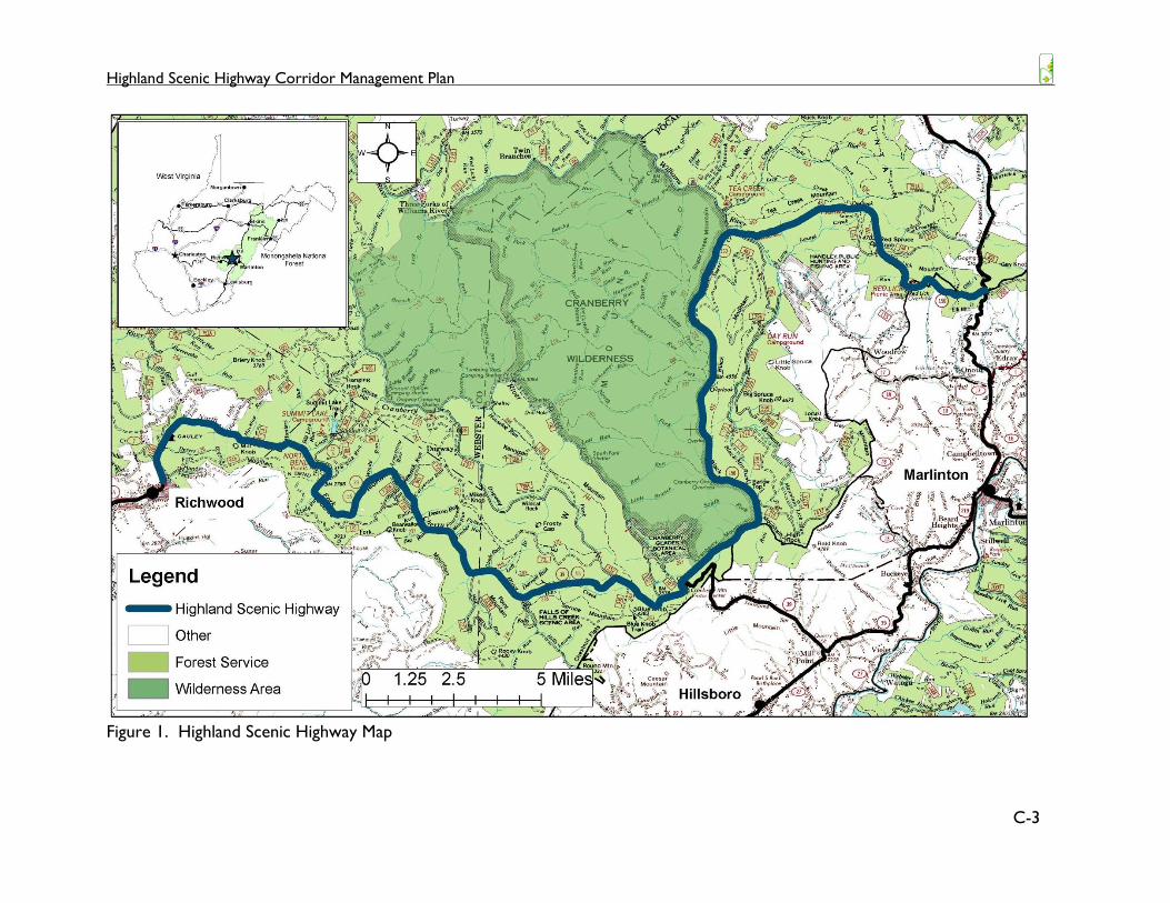
Figure 1. Highland Scenic Highway Map ..................................................................................................... 3
Figure 2. Fall foliage along the HSH ............................................................................................................. 4
Figure 3. HSH portal sign at WV 39 ........................................................................................................... 5
Figure 4. Tea Creek Meadow Interpretive Trail ...................................................................................... 6
Figure 5. Theme and subthemes ............................................................................................................... 12
Figure 6. Geographic Location of Priority 1 Sites ................................................................................. 16
Figure 7. Falls of Hills Creek Scenic Area ............................................................................................... 18
Figure 8. National Park Service's National Natural Landmark logo .................................................. 19
Figure 9. Williams River Valley Overlook ............................................................................................... 21
Figure 10. Tea Creek Meadow Interpretive Trail .................................................................................. 24
Figure 11. Geographic Locations of Priority 2 Sites ............................................................................. 25
Figure 12. Summit Lake ............................................................................................................................... 26
Figure 13. Williams River at the Fishing Pier .......................................................................................... 28
Figure 14. Williams River Deadwaters .................................................................................................... 29
Figure 15. Beaver Pond on Tea Creek Interpretive Trail 2002 ......................................................... 30
Figure 16. Black Cherry Sign along the Cranberry Mountain Nature Trail .................................... 31
Figure 17. Geographic Locations of Priority 3 Sites ............................................................................. 32
Figure 18. Installed interpretation along the Mill Point Interpretive Trail. ...................................... 33
Figure 19. Mill Point Prison Site ................................................................................................................ 33
Figure 20. Interpretive Signs at Honeycomb Rocks.............................................................................. 36
Figure 21. Geographic Locations of Trailheads. .................................................................................... 39
Figure 22. Thomas Reserve Trailhead can serve other area trails. ................................................... 40

Highland Scenic Highway Corridor Management Plan
C-1
Section 1 Introduction As a jewel of the Monongahela National Forest, the Highland Scenic Highway draws visitors
from around the country to enjoy the beautiful mountain vistas, clear water streams, and a
wide array of recreational opportunities. Winding through the rugged terrain of the Allegheny
highlands, the Highland Scenic Highway provides a glimpse into the past in one of the last areas
to be timbered in the logging boom of the early half of the 1900s. This area is rich in history
and folklore. The Forest tells the story of a vast, untouched wilderness, once destroyed by the
axe, that has recovered to provide wildlife habitat, water, timber, forest products, as well as a
place to escape everyday life.
The Highland Scenic Highway is a 43-mile route that traverses the southern portion of the
Monongahela National Forest. It is located on both the Marlinton and Gauley Ranger Districts,
primarily on Forest Service land (Figure 1). From Richwood, West Virginia, it follows WV
39/55 for 21 miles through the narrow valley along the North Fork of the Cherry River, climbs
to the top of Kennison Mountain and continues onto the Cranberry Mountain Nature Center.
From the Nature Center, the Highland Scenic Highway turns onto WV 150 and meanders
across 22 miles of the area’s highest ridges and plateaus before connecting with US 219, just 7
miles north of Marlinton, West Virginia.
Visitors can explore scenic areas, such as the Fall of Hills Creek and the Cranberry Glades
Botanical Area. The Cranberry Glades Botanical Area is also listed as a National Natural
Landmark. Fishing access is available on the streams and rivers that parallel the roadway.
Other fishing opportunities are just off Highway at Summit Lake and the Williams River. As the
eastern boundary of the Cranberry Wilderness, the Highland Scenic Highway provides several
access points for those seeking solitude and adventure. Front country hiking and mountain
biking are also found along the way. Scenic overlooks offer picnicking and broad views into
picturesque, rural valleys below. Camping is offered at developed and dispersed recreation
areas within a few minutes from the Highland Scenic Highway.
Additional recreation opportunities are available as the seasons change. The fall leaf season is
one of the busiest times of the year, as the maple, yellow poplar, oak, and hickory showcase
their vivid hues of reds, oranges, and yellows. It is also a very popular corridor to access
favorite hunting spots. Unmaintained during the winter, the WV 150 section of the Highland
Scenic Highway is the only place on the Monongahela National Forest where snowmobiles are
allowed. Along with the snow-covered roadway, a modest trail system offer cross-country
skiing and snow shoeing opportunities. There is also a significant amount of cross-country
skiing on trails near the Cranberry Mountain Nature Center and Cranberry Glades Botanical
Area.

Highland Scenic Highway Corridor Management Plan
C-2
Section 2 Interpretive Planning and Goals
Interpretation is…
The goal of any interpretive material is to foster a connection between the land and the people
use it. Through talks and presentations, signs and handouts, the goal remains the same—to
help the public create an appreciation of the resource they use and a greater understand of its
value to both the natural environment and society.
During the development of the Highland Scenic Highway Corridor Management Plan (HSH
CMP), the Monongahela National Forest (the Forest) realized a need to revisit, improve, and
expand interpretive opportunities offered to the public. While several educational and
interpretive opportunities exist along the Highland Scenic Highway (HSH), there are many
stories to be told to connect visitors to the land they have come to explore and enjoy.
This interpretive plan will lay the framework for the improvement and development of
historical and environmental education opportunities along the HSH. It will assist Ranger
Districts to develop interpretive materials with consistent storylines, visual appearance, as well
as accessibility. Visitors and local citizens alike will form a better appreciation for the Forest, its
management, and the communities connected to it. By offering high-quality, appealing
interpretive materials, there may be an increase in visitors to the area, improving tourism and
economic development in nearby communities of Richwood, Hillsboro, and Marlinton, WV.
Goals of Interpretive plan:
Use a thematic approach along the HSH to help create a ‘brand’ or identity for the route,
allowing it to stand out among the surrounding landscape.
Improve visitor understanding of plant biology, forestry, wildlife, geography, ecology, geology,
and other natural sciences.
Connect visitors to the land by telling stories of the Forest’s past, how it has recovered, and
the multitude of services it provides to society.
Foster an understanding of safety concerns, forest regulations, and outdoor ethics through
clear and consistent information.
Improve marketing of area attractions, as well as services available on the HSH and in nearby
communities.
Provide a variety of high-quality education opportunities to visitors regardless of age or
ability.
‘an educational activity which aims to reveal meaning and relationships through the use of
original objects, by firsthand experience, and by illustrative media, rather than simply to
communicate factual information (Tilden, 1957)’.
Highland Scenic Highway Corridor Management Plan
C-3
Figure 1. Highland Scenic Highway Map

Highland Scenic Highway Corridor Management Plan – Appendix C
C-4
Section 3 Audience Analysis Little data has been collected specifically for visitors of the HSH, though visitor logs are kept at
the Cranberry Mountain Nature Center which is located on the HSH. Almost 3,500 visitors
signed in during the 2012 season, which ran from mid-April through mid-October.
Approximately 63% of the visitors were from West Virginia, with the neighboring states of
Virginia, Ohio, and Pennsylvania having the next highest number of visitors signed in. Visitors
also came from California, Colorado, and South Dakota, and from as far as Canada, and
Denmark. The reasons people stated for visiting the area were primarily for sightseeing and
recreation. Activities that fall under
sightseeing include viewing fall foliage, scenic
drives, and visiting the Cranberry Glades
Botanical Area. Recreational purposes
include, but are not limited to, hiking,
backpacking, camping, biking, birding, and
fishing.
Reports from the Forest-wide National
Visitor Use Monitoring (Kocis et. al., 2004)
study shed some additional light as to who is
visiting the Forest. An understanding of who
uses the area must be established to
effectively communicate the thematic
storylines. Considerations of age ranges, group sizes, and amount of time spent are just a few
examples of information needed to gauge when, how, and where interpretive displays should be
developed.
Based on findings in the 2004 NVUM report, there were over 1 million national forest visits in
FY2003. A ‘National Forest Visit’ is defined as: the entry of one person upon a national forest to
participate in recreation activities for an unspecified period of time. A National Forest Visit can be
composed of multiple Site Visits. Nearly three-quarters of visitors to the Forest were male (71%)
and the majority of visitors were white (96%). Average group size was 2.43. Age was fairly
evenly distributed, with about 40 percent reporting they were between the ages of 40 and 59.
Persons under 16 represented another 16 percent.
The average visit duration was 20.9 hours on the Forest. Just below one-fifth of visitors
reported staying overnight on the Forest. Visitors reported viewing natural features, viewing
wildlife, relaxing, hiking/walking, and driving for pleasure as the top five activities they
participated in during their National Forest visit. Fishing and participating in nature center
activities were also notable activities reported by visitors. The most common ‘facilities and
specially designated areas’ visited were forest roads, forest trails, scenic byways, wilderness, and
Figure 1. Fall foliage along the HSH

Highland Scenic Highway Corridor Management Plan – Appendix C
C-5
museums. Over three-quarters of visitors to the Forest reported that recreating on the Forest
was the primary goal of their trip. When asked how many times they visit to participate in all
the activities specified, the average visitor comes to the Forest 20.7 times over a 12 month
period.
When asked about how important a variety of items
were and their satisfaction with what they
encountered during their time on the Forest, visitors
were specifically asked about interpretive displays
and the availability of recreation information.
Visitors to developed day use areas rated
interpretive displays as ‘important’ on a 5-point
Likert scale, and 94 percent reported ‘good’ to ‘very
good’ satisfaction levels. Similarly, these visitors
rated recreation information availability as
‘important’ with 85 percent reporting ‘good’ to ‘very
good’ satisfaction levels. Visitors at developed
overnight sites placed these items at ‘moderate
importance’ and just over three-quarters reported
‘good’ to ‘very good’ satisfaction levels.
Overall, this information tells us that there is
significant use on the Forest by small groups of
people that come to the Monongahela to enjoy the
outdoors in a variety of settings. When they have an
opportunity to learn through interpretation, they feel
that what they encounter is satisfactory. The development of updated and improved
interpretation can help visitors learn more, while forming a greater appreciation of the land that
they return to time and time again. It can help lengthen visitors’ stay by offering more to see
and learn on the HSH, at developed recreation sites along the way, as well as in nearby
communities.
Figure 2. HSH portal sign at WV 39

Highland Scenic Highway Corridor Management Plan – Appendix C
C-6
Section 4 Existing Interpretive Sites To understand what interpretation needs exist along the HSH, a brief history and description of
opportunities currently offered is included here (Table 1).
Interpretive Trails
Several interpretive trails are located at scenic areas across the HSH. Conceptualized as part of
the “Wayside Exhibit Plan for the Highland Scenic Highway” in 1993, the Black Mountain Fire
Trail was completed in 1996. Other trails have
developed over time, and include:
Falls of Hills Creek
Cranberry Glade Boardwalk
Cranberry Mountain Nature Trail
Mill Point Prison Site
Black Mountain Fire Boardwalk
Honeycomb Rocks Trail
Tea Creek Meadow Interpretive Trail
Signs and Kiosks
Although primarily for regulations and trail
information, trailhead signs along the HSH often
include some interpretive information about the trail or the area it traverses. Recently
designed and installed trailhead displays at Red Spruce Knob Trail, Gauley Mountain Trail, and
Williams River Trail include historical information related to the logging and post-logging era.
High Rocks Trailhead is a dated sign that provides some interpretation about the geology of the
rock formation and some avian species that may be seen along the trail. Other trailheads do
not have an established trailhead sign at this time.
There is a three-panel kiosk at the US 219/WV 150 gateway to the HSH. One panel is
dedicated to seasonal information (wildflowers, winter recreation). The main panel displays an
overview map of the HSH, highlighted recreational areas, and stopping points. The Pocahontas
County Convention and Visitors Bureau (PCCVB) update the final panel with local events and
tourist information.
Overlooks
Three of the four overlooks along the WV 150 section of the HSH have panoramic signs with
interpretive information about the landscape and resources seen from their vistas. These signs
were designed and implemented in 1994 based on the guidance provided in the “Wayside
Exhibit Plan for the Highland Scenic Highway”, 1993.
Figure 3. Tea Creek Meadow Interpretive
Trail
Highland Scenic Highway Corridor Management Plan – Appendix C
C-7
Gauley Ranger District Office
At the Gauley Ranger District Office there is a three-panel kiosk that offers District recreation
information, notices, area maps, and various brochures. The lobby area has a historical
interpretation area developed in 2001. It includes many historical photos of Richwood during
the early timber days, loggers, historic railroads, as well as New Deal era photos of the Civilian
Conservation Corps (CCC). USDA Forest Service-owned artifacts are on display. For a short
time, additional items on loan from the Smithsonian were included in the display, but have been
returned. There is also a large ‘Bear Aware’ display that educates visitors about proper food
storage and practices to avoid negative encounters with black bears that frequent recreation
sites.
Cranberry Mountain Nature Center
As the primary visitor center along the HSH, the Cranberry Mountain Nature Center (CMNC)
offers a variety of interpretive services ranging from presentations, interactive displays, live
animals, and self-guided exhibits. It is located near the mid-point of the HSH and is seasonally
open from April to October.
Talks and Events
‘Snakes of West Virginia’ and guided tours of the Cranberry Glades Botanical Area are regular
weekend programs. The CMNC also holds free events such as the Conservation Day/Kids’
Night and the Cranberry Shindig. During these events, local artisans setup demonstrations:
blacksmithing, wood carving, wood turning/lathing, spinning thread, soap making, making apple
cider, quilting, and many other traditional trades. Traditional music and dance is another
highlight of the Shindig. Native orchids and backyard medicine programs have become annual
events as well.
Self-guided, interactive exhibits
Throughout the CMNC, visitors can learn about wildlife, habitats, and many other topics
related to the Forest. Exhibits found there are as follows:
Geography
Relief map of the Gauley Ranger District centered on the Cranberry Wilderness and
surrounding area (HSH included).
Hand-made wall quilt displays a map of the entire forest.
Geology
West Virginia’s Gemstone: Fossil Coral. Hands-on exploration of fossils.
Sample of Forest soil, along with profile diagram.
Forest Health
Forest pests. Panels describing forest health issues related to invasive pests: Hemlock
Wooly Adelgid and Emerald Ash Borer.

Highland Scenic Highway Corridor Management Plan – Appendix C
C-8
Wildlife
Artificial animal scat display.
Animal tracks: Visitors can make prints in the sand for many wildlife species found in the
area.
Twenty-one mounted wildlife species displayed in habitat scenery. Associated flip-books
teach visitors about common species and their habitat.
Fourteen birds of prey, a loon, a hummingbird, and red crossbill are on display.
Live snake exhibit: Venomous and non-venomous snakes of West Virginia.
Trout of West Virginia: Includes aquarium with live brook trout and an interpretive panel.
Bear exhibit: Full-scale cutouts of polar, grizzly, and black bear with associated skulls.
Vegetation
Wildflowers in bloom by season.
Wildflower identification window clings of native species that can be found in gardens
around the CMNC.
Miscellaneous
Mystery boxes: Visitors reach inside box and try to guess the object they find.
Films
A variety of interpretive films are available for viewing at the Center. Topics include:
wildflowers, Smokey Bear, Cranberry Glades Botanical Area, Snakes, Hummingbirds, Civilian
Conservation Corps., and Mount Saint Helens.
Outdoor Interpretive Opportunities
The Cranberry Mountain Nature Trail is located steps away from the CMNC. It introduces
visitors to many of the local tree species as it leads to a picnic spot at an overlook into the
Stamping Creek watershed. The Virginian mountains are visible in the distance.
There is also a four-sided kiosk that offers area maps, information about forest notices,
regulations, and upcoming local events. Native wildflower gardens around the complex teach
visitors how to identify species on-site and the importance of planting native species.

Highland Scenic Highway Corridor Management Plan – Appendix C
C-9
Table 1. Existing Interpretive Sites
Location Site Description Interpretive themes or
goals
Gauley Ranger
District Office Bear Aware Kiosk
Small display area with interpretive information related to historic logging, railroads, and their impact on industry and the
development of Richwood. Also stories about Civilian
Conservation Corp. Also includes many artifacts from CCC and
logging camps (2001).
Three-panel kiosk with general area information, maps, notices, and
various brochures (2003).
o General area information
and visitor safety
o Wildlife
o Logging
o Post-logging
Summit Lake Single routed plastic sign, describing lake, stocking, a few basic regulations for lake use (2006).
o General area information
o Recreation
Falls of Hills Creek
Scenic Area Single routed cedar sign with short description of waterfalls and
trail, as well as site map (mid-1990s).
Single-paneled sign describing the geology of waterfall formation
(2007).
Single-panel laminate sign mounted in metal frame describing NNIS, Hemlock Wooly Adelgid (~2008).
o General area information
o Forest health (NNIS)
Cranberry Glades
Botanical Area
Boardwalk
Newer routed cedar sign at entrance with area history and description.
Large single-paneled kiosk with five inserts with boardwalk map,
area plants, and ways to help protect the area. Seven small signs
mounted in aluminum frame with glass located along 0.5 mile
boardwalk (1990).
o General area information
o Ecological interpretation:
wildlife, unique habitat,
botany, history
Cranberry
Mountain Nature
Center (outdoor)
Four-sided information kiosk with maps, forest information, Nature
Center events, Notices from USFS and WVDNR (2003).
Short, looping interpretive trail with introductions to thirteen tree/plant species, as well as historical description of the forest and
o General area information
o Natural resource
management

Highland Scenic Highway Corridor Management Plan – Appendix C
C-10
Location Site Description Interpretive themes or
goals
a pictorial diagram of the Stamping Creek overlook (2007).
Mill Point Prison
Site Interpretive trail (0.5 miles) created on an existing trail. Ten signs
tell the story of the Mill Point Prison (2010).
o Post-logging
High Rocks
Trailhead Trailhead display with trail information, the story of High Rocks,
and birds to see along the way. Emergency contact information
and area map (1990s).
o General area information
o Geology
o Wildlife
Williams River
Valley Overlook Single-paneled panoramic view of the Williams River Valley.
Diagram of places in view shed, establishment of MNF, and lineage
of the Williams River to the Gulf (1994).
o Geography
o Natural resource
management
o Water resources
Big Spruce
Overlook Single-paneled sign describing red spruce logging history. Also
introduces the Black Mountain Fire and leads visitors to the
interpretive trail (1994).
o Logging
o Post-logging (fire) Forest
resiliency
Black Mountain
Fire Trail Interpretive trail (600' boardwalk) with 7 small signs describing the
logging history of the area, the Black Mountain fire (soil loss), and a
recovering forest (1996).
o Logging
o Post-logging (fire)
o Influences on forest health
Williams River
Trailhead Trailhead display with trail information and story about the splash
dam located there during the logging era. Emergency contact
information and area map (2010).
o General area information
o Logging
Honeycomb Rocks
Trail Interpretive trail (0.25 miles) with 11 signs teaching visitors about
the unique geology of the Honeycomb Rocks (2007).
o Geology
Little Laurel
Overlook Single-paneled panoramic view of the valley, pointing out places in
view shed. Also describes the MNF as a 'working' forest with
forest management and grazing while providing wildlife habitat and
recreational opportunities (1994).
o Geography
o Current timber practices,
forest resiliency

Highland Scenic Highway Corridor Management Plan – Appendix C
C-11
Location Site Description Interpretive themes or
goals
Tea Creek Meadow
Interpretive Trail Interpretive trail (0.6 miles) with 6 signs describing the history of
the meadow, habitat diversity, and wildlife. Two wildlife blinds are
located along the boardwalk portion of the trail (2005).
o Wildlife, water/wetlands,
habitat
Gauley Mountain
Trailhead Trailhead display with trail information and historic railroad logging.
Emergency contact information and area map (2012).
o General area information
o Logging
Red Spruce Knob
Trailhead Trailhead display with trail information and a historic account about
the fire tower staffed by the Civilian Conservation Corps (2010).
o General area information
o Post-logging: Fire tower
and CCC
US-219 Gateway
Parking Three-paneled kiosk with seasonal forest information (winter
recreation, wildflowers), a map of the HSH and area information,
and local Convention and Visitors Bureau information (2002).
o General area information
o Wildflowers

Highland Scenic Highway Corridor Management Plan – Appendix C
C-12
Section 5 Interpretive Theme and Subthemes During the development of the HSH CMP, public meetings and letters to the public, area
partners and businesses called for ideas pertaining to interpretive opportunities along the HSH.
This input, as well as discussions during on-forest meetings, was used to establish the overall
theme and subthemes for interpretation in this plan (HSH CMP, 2012).
The main theme that will be used to tie interpretation across the HSH is The Forest is Our
Future (Figure 5). Many stories and ideas important to those who participated in the
development of the theme and subthemes were related to the historical use and settlement of
the area, how the forest has recovered and what resulted from historical use of the land, and
what is being done now to shape what it will look like in the future, as well as the ecological
benefits it will provide as time passes. Subthemes are outlined below (adapted from HSH
CMP, 2012). Refer to this outline when reviewing the recommended themes.
The Forest is Our Future
Highland Scenic Highway
Past
Our Forest has a rich history.
Present
Our Forest is resilient.
Future
Our Forest is dynamic.
Figure 4. Theme and subthemes

Highland Scenic Highway Corridor Management Plan – Appendix C
C-13
1. Past: Our Forest has a rich history.
Storylines explore past uses and historic settlement in the area and how they were
shaped by the surrounding forests and mountains.
a) Historic Settlement: Subsistence farming, pastimes, and daily life in a remote
mountainous area.
b) Logging Era: Railroad logging, timber-based industry and manufacturing, logging
camps and towns.
c) Post-logging: Wildfire, fire suppression efforts, forest restoration, Mill Point
Prison, and Civilian Conservation Corps.
2. Present: Our Forest is resilient.
Storylines explore how the forest is comprised of recovering ecosystems, subject to a
variety of influences and management strategies.
a) Influences: Environmental factors that can impact the forest such as weather,
acid rain, natural succession, and elevation.
b) Natural Resource Management: Current management practices for wildlife
habitat improvement, managing for sensitive species, non-native invasive species,
recreation, timber and more.
c) Ecosystem Benefits: Benefits to environment and people such as air and water
filtration, carbon sequestration, biodiversity, a variety of recreation
opportunities/settings, quality of life, sensitive species, common wildlife,
wildflowers, and tree identification.
3. Future: Our Forest is dynamic.
Storylines explore current forest trends and how they may shape our forests in the
future, along with the challenges and benefits of change.
a) Ecosystem Health: Issues that are impacting specific tree species, invasive pests
and plants, as well as management strategies to address them.
b) Water: Origins of several rivers are found in this high elevation area, provides
habitat, fisheries, and water source for local communities.
c) Geology: Site specific interpretation where appropriate, such as Falls of Hills
Creek, Cranberry Glades Botanical Area, and Honeycomb Rocks.

Highland Scenic Highway Corridor Management Plan – Appendix C
C-15
Section 6 Interpretive Site Prioritization and
Recommendations The variety of storylines developed around the HSH allows managers to use a range of
interpretive methods. Some storylines may be better suited for an audio tour or a brochure
dedicated to that topic, while others should be shared through site-specific interpretive
displays. To reach the greatest number of visitors, these stories should be offered through
multiple media types. Accessible materials, such as large print and audio formats, should be
available upon request.
In additional to prioritization of interpretation development at key sites along the HSH, high
importance should be placed on the development of other materials, such as a HSH-dedicated
website and audio tour built around subthemes. The website will be important not only for an
additional outlet for interpretation, it will help market the intrinsic, scenic, and historical
qualities of the HSH.
The recommendations within the CMP are locations and concepts that have been identified
within the Forest Service, and from public meetings, for improving and enhancing interpretive
opportunities associated with the HSH. The themes and subthemes provide a framework for
future opportunities to be developed, yet be connected to a more comprehensive interpretive
theme and visitor experience.
Prioritization
Existing site conditions, use patterns, proximity to other points of interest, and benefit to
visitor experience were considered when determining the desired level of on-site
interpretation. Priorities were established as 1, 2, or 3.
Priority1: These are high profile sites with a well-developed infrastructure in place. They serve
as portals or key destinations along the HSH.
Priority 2: These sites receive a substantial amount of use and have some infrastructure in place
to support the development of more in-depth interpretation.
Priority 3: These sites include replacing interpretive information that was more recently
installed and creating new interpretive opportunities at less prominent sites or locations.
Priority 4 Trailheads: Numerous trailheads are located in the HSH area. These represent
additional opportunities to tie recreation to the HSH and incorporate interpretive material into
trailhead signs.

Highland Scenic Highway Corridor Management Plan – Appendix C
C-16
The priorities are organized as such, that if funding were received for interpretation along the
HSH, implementing recommendations for a Priority 1 site would be desirable before Priorities
2, 3, or Priority 4 Trailheads.
The site numbers are in sequential order starting from the western end of WV 39 travelling to
the junction of WV 150 and US 219.
Site Recommendations
Priority 1
These are high profile sites with well-developed infrastructure in place. These sites serve as
either a portal for visitor orientation to the HSH or key destination along the way. These
priority sites should also include audio tour linked to the website.
The most important places to help develop the identity of the HSH are at the portal sites:
Gauley RD Office Kiosk, the Cranberry Mountain Nature Center, and the US-219 Gateway. Visitors
need to know where they are going, what they are travelling on, and why it will be memorable
to them and their companions (Table 2).
Focus should then be turned to the high profile and key sites along the HSH: Falls of Hills Creek
Scenic Area, Cranberry Glades Botanical Area, and the four scenic overlooks. These sites are well-
defined, offer amenities, and showcase a wide variety of scenic viewing opportunities. Already
drawn to these areas for their spectacular beauty, interpretation needs to be updated to help
visitors form a greater appreciation of the site, develop place attachment, and stir their
curiosity about the development of the landscapes they are enjoying. For more detail
regarding their existing condition information, see Table 1 Existing Interpretive Sites
Table 2. Priority 1 Sites
# Site Name
1 Gateway Trailhead
2 Gauley Ranger District Office
8 Falls of Hills Creek Scenic Area
11 Cranberry Glades Botanical Area
13 Cranberry Mountain Nature Center
19 Williams River Valley Overlook
22 Big Spruce Overlook
34 Little Laurel Overlook
39 Red Lick Overlook
41 US-219 Gateway

Highland Scenic Highway Corridor Management Plan – Appendix C
C-17
Figure 6. Geographic Location of Priority 1 Sites
Highland Scenic Highway Corridor Management Plan – Appendix C
C-18
Site 1: Gateway Trailhead
Topic: Recreation management is geared towards the safety and health/wellness of local
residents/families that enjoy recreating close to home. A forest in recovery provides social and
environmental benefits.
Themes: 2b Natural Resource Management, 2c Ecosystem Benefits, general orientation
Objective: As a result of this exhibit, visitors will
Be oriented and will know basic trail and emergency information,
Discover nearby recreational opportunities on the National Forest
Understand how the forest has recovered from past industrial logging practices and
provides for continued economic, as well as social and environmental, benefits today
Existing condition: Existing undeveloped trailhead and trail access.
Desired condition: Trailhead sign orients visitors. Trailhead information includes a brief trail
description, area map, emergency contact information, and Gauley District contact information.
Interpretive method recommendations: A double-panel, vertical trailhead display
List of graphic needs: Area map, photos of then and now.
Notes: While this site is not yet well-developed, funding is secured for the desired
improvements. Once developed this will be a high profile site due to its location.
Site 2: Gauley Ranger District Office
Topic: The Gauley Ranger Station is a portal for visitors to the HSH. Outdoor information is
available to orient visitors to the HSH, seasonal information and opportunities regarding the
National Forest, and nearby attractions.
Themes: All, general orientation
Objective: As a result of this exhibit, visitors will
Be oriented with the HSH and attractions along the way
Gain a greater understanding of National Forest regulations
Inform visitors about local events and opportunities on the Forest and in nearby
communities
Appreciate the year-round opportunities on the National Forest
Existing condition: Extensive indoor interpretive displays. Existing outdoor three-panel kiosk is
in need of replacement and is outdated.

Highland Scenic Highway Corridor Management Plan – Appendix C
C-19
Desired condition: No recommendations for indoor interpretation. The outdoor three panel
kiosk is replaced with a tri-fold design and has updated orientation and interpretive information.
The center panel should be developed to offer visitors an overview map of the HSH, attractions
along the way, as well as general information/regulations (currently being developed). One
panel should offer an introduction to the themes and subthemes that will tie their scenic drive
together. One panel should be dedicated to information about local events/festivals, special
notices, and seasonal changes across the Forest (winter recreation, fall colors, wildflowers,
wildlife, and so on).
Interpretive method recommendations: Three signs needed for the three panel kiosk.
List of graphic needs: HSH map and nearby attractions, photos relevant to themes/subthemes,
seasonal images/information.
Notes: Orientation signs should be consistent with CMNC and the 219 Gateway. Coordinate
with Richwood Chamber of Commerce for local event information. These panels should be
created for the dimensions of the tri-fold information board at the CMNC, as well as the US-
219 Gateway.
Site 8: Falls of Hills Creek Scenic Area
Topic: A series of interpretive signs focus on geology, the unique vegetation that thrive near the
falls, and the movement of surface and subsurface water. Hemlock wooly adelgid threatens the
health of nearby eastern hemlock trees.
Themes: 3a Ecosystem Health, 3b Water, 3c
Geology
Objective: As a result of this exhibit, visitors will
Learn how geologic forces created and
shaped the Falls
Gain an understanding of surface and
subsurface water flow, and how the water from the
Falls travels to the Greenbrier River
Understand the importance of the eastern
hemlock and the threat of the hemlock wooly
adelgid
Appreciate the unique vegetation that grows
near the Falls
Existing condition: Some of the signs are outdated
Desired condition: Updated information is accurate
Figure 7. Falls of Hills Creek Scenic
Area

Highland Scenic Highway Corridor Management Plan – Appendix C
C-20
and signs meet media design guidelines.
Interpretive method recommendation: Interpretive trail, three panel kiosk, brochure, and audio
tour
List of graphic needs: Some existing graphics can be used, some need to be replaced
Notes: Hemlock wooly adelgid sign replacement should be in partnership with USDA Forest
Service Northeastern Area
Site 11: Cranberry Glades Botanical Area
Topic: Cranberry Glades Botanical Area and National Natural
Landmark protect the largest area of bogs in West Virginia. Because
of its unique conditions, some unusual plants grow in fens
(commonly called bogs), including carnivorous or insect-eating
plants.
Themes: 2a Influences, 2b Natural Resource Management, 3c
Geology
Objective: As a result of this exhibit, visitors will
Learn what a bog is and how it formed
Gain an understanding of the hydrology and geology of the area
Appreciate the unique vegetation that grows in the Cranberry Glades
Existing condition: Existing trailhead information board and interpretive trail signs are outdated
and in poor condition.
Desired condition: Updated information is accurate and signs meet media and architectural
guidelines.
Interpretive method recommendation: Interpretive trail, trailhead information board, brochure,
and audio tour
List of graphic needs: Incorporate existing graphics with new as appropriate
Notes: As a National Natural Landmark, the associated logo should be incorporated on the
entrance information board (Figure 11). Ensure consistency across media types. The trailhead
information board should be replaced with a two-panel kiosk shown in Figure 23 of the HSH
CMP. Individual interpretive sign at stops along the boardwalk should be replaced with small
angled interpretive displays of similar dimensions.
Figure 8. National Park
Service's National Natural
Landmark logo

Highland Scenic Highway Corridor Management Plan – Appendix C
C-21
Site 13: Cranberry Mountain Nature Center
Topic: This portal site welcomes people to the HSH. Information and opportunities along the
HSH and the surrounding National Forest, general Forest regulations and information, nearby
attractions, and local events are provided.
Themes: All, general orientation
Objective: As a result of this exhibit, visitors will
Be oriented with the HSH and attractions along the way
Gain a greater understanding of National Forest regulations
Inform visitors about local events and opportunities on the Forest and in nearby
communities
Appreciate the year-round opportunities on the National Forest
Discover the extent of trails that are in the vicinity, both within walking distance and
nearby
Existing condition: Extensive indoor interpretive displays. Existing outdoor four-sided
information board is in poor condition and outdated.
Desired condition: No recommendations for indoor interpretation at this time. A tri-fold
design should be used to replace the existing information board. Orientation signs should be
consistent with Gauley Ranger District Office and the 219 Gateway.
Interpretive method recommendation: Signs needed for the kiosk.
List of graphic needs: HSH map and nearby attractions, photos relevant to themes/subthemes,
seasonal images/information
Notes: Coordinate with PCCVB for local event information. Kiosk panels should be created
for the dimensions of information board at the Gauley Ranger District Office, as well as the US-
219 Gateway. Three panels will be dedicated to HSH, the other side of which will pertain to
CMNC.
Site 19: Williams River Valley Overlook
Topic: Looking over the Williams River Valley is looking into the foundation of rivers.
Themes: 2c Ecosystem Benefits, 3b Water
Objective: As a result of this exhibit, visitors will
Understand how forest management practices affect streams and rivers
Gain a greater understanding of how fisheries and wildlife depend on forest management
Be informed of the distances (bird’s flight) to features/mountains in the viewshed

Highland Scenic Highway Corridor Management Plan – Appendix C
C-22
Appreciate how forest management actions can influence what happens downstream,
including providing recreation and water source for communities
Existing condition: Single interpretive panel sign and parking access for the Black Mountain Trail.
Desired condition: Single sign is updated and meets media and architectural guidelines.
Interpretive method recommendation: Single angled interpretive panoramic sign.
List of graphic needs: Incorporate existing graphics
Notes: Because this site is also an access point to the Black Mountain Trail (TR 412) that loops
along the ridge to the Big Spruce Scenic Overlook, a separate interpretive display about
differences in managing wilderness and non-wilderness areas will be included on-site. Refer to
the Trailheads section for more detailed information.
Site 22: Big Spruce Overlook
Topic: History and restoration of the red spruce ecosystem and contrast between past and
current resource management.
Themes: 1b Logging Era, 1c Post-logging, 2b Natural Resource Management
Objective: As a result of this exhibit, visitors will
Understand how USDA Forest Service ownership and management has shaped the
forest they see today
Gain a greater understanding of the red spruce ecosystem and its historic distribution
Learn about the wildlife whose habitat includes or relies on the red spruce ecosystem
Existing condition: Single angled interpretive panel sign.
Figure 9. Williams River Valley Overlook
Highland Scenic Highway Corridor Management Plan – Appendix C
C-23
Desired condition: Single sign is updated and meets media and architectural guidelines.
Interpretive method recommendation: Single angled interpretive panoramic sign.
List of graphic needs: Incorporate existing graphics
Notes:
Site 34: Little Laurel Overlook
Topic: The patchwork landscape provides diverse vegetation and wildlife habitat.
Themes: 2b Natural Resource Management
Objective: As a result of this exhibit, visitors will
Have a greater understanding of the forest patterns they are viewing
Learn about how forest diversity provides a variety of wildlife habitat
Existing condition: Single angled interpretive panel sign.
Desired condition: Single sign is updated and meets media and architectural guidelines.
Interpretive method recommendation: Single angled interpretive panoramic sign.
List of graphic needs: Incorporate existing graphics
Notes: A chlorophleth map developed in ArcGIS could depict this idea well. Refer visitors to
the Tea Creek Meadow Trail for a closer look at two very different habitats and how they are
linked.
Site 39: Red Lick Overlook
Topic: Natural influences on forest development.
Themes: 2a Influences, 2c Ecosystem Benefits
Objective: As a result of this exhibit, visitors will
Learn about the viewshed, feature names and distances
Understand how natural factors such as aspect, weather, elevation and geology influence
forest development and species composition
Existing condition: No sign.
Desired condition: Single angled panoramic interpretive sign meets media and architectural
guidelines.
Interpretive method recommendation: Single angled interpretive panoramic sign.

Highland Scenic Highway Corridor Management Plan – Appendix C
C-24
List of graphic needs: Panorama of viewshed
Notes: Consistent with other overlook signs.
Site 41: US-219 Gateway
Topic: Outdoor information orients visitors to the HSH, the surrounding National Forest, and
nearby attractions.
Themes: All, general orientation
Objective: As a result of this exhibit, visitors will
Be oriented with the HSH and attractions along the way
Gain a greater understanding of National Forest regulations
Inform visitors about local events and opportunities on the Forest and in nearby
communities
Appreciate the year-round opportunities on the National Forest
Realize the extent of trails that are in the vicinity
Winter visitors will be informed of the variety of snow-based recreation along the HSH
Existing condition: Existing kiosk is in good condition. Center panel and PCCVB panel need to
be updated.
Desired condition: The center panel provides an overview map of the HSH, attractions along
the way, as well as general information/regulations (currently being developed). PCCVB
provides one panel of information about local events/festivals, lodging information, and nearby
attractions. One panel provides seasonal information relating to the Forest (winter recreation,
fall colors, wildflowers, wildlife, and so on), special notices, and Wilderness. Orientation signs
should be consistent with Gauley Ranger District Office and the Cranberry Mountain Nature
Center.
Interpretive method recommendation: Signs needed for the kiosk.
List of graphic needs: HSH map and nearby attractions, photos relevant to themes/subthemes,
seasonal images/information
Notes: Coordinate with PCCVB for local event information. Kiosk panels should be created
for the dimensions of the four-sided information board at the CMNC, as well as the Gauley
Ranger District Office.