introducing spatial views for location aware applications with couchbase server 4.0: couchbase...
TRANSCRIPT
INTRODUCING SPATIAL VIEWS FOR LOCATION AWARE APPLICATIONS WITH COUCHBASE SERVER 4.0
Simon LeighSolutions Engineer
David MaierPrincipal Solutions Engineer

©2015 Couchbase Inc. 2
Agenda
A bit of History Introduction Typical Use Cases Technical Overview Demo

A bit of History

©2015 Couchbase Inc. 4
A bit of History
Did you know? Already in 2.x and 3.x Marked as experimental
Since then Performance and Stability
improvements GA in 4.0
Further Improvements will follow Radius, Polygon, …
IntroductionGeo- and Spatial Indexes
©2015 Couchbase Inc. 6
Introduction
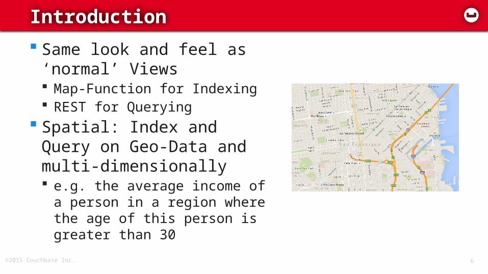
Same look and feel as ‘normal’ Views Map-Function for Indexing REST for Querying
Spatial: Index and Query on Geo-Data and multi-dimensionally e.g. the average income of a
person in a region where the age of this person is greater than 30

Typical Use Cases
©2015 Couchbase Inc. 8
Use Cases
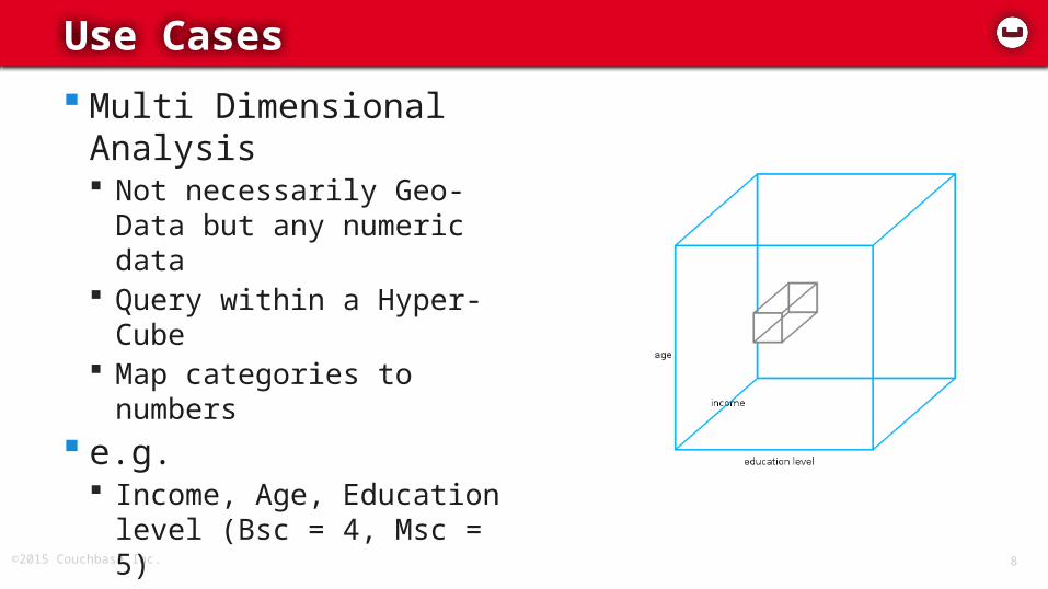
Multi Dimensional Analysis Not necessarily Geo-Data
but any numeric data Query within a Hyper-Cube Map categories to
numbers e.g.
Income, Age, Education level (Bsc = 4, Msc = 5)
Timestamp, Log-Level

©2015 Couchbase Inc. 9
Use Cases
Geo-Data GeoJSON: the “Open Standard” More complex geometries stored as
regions Bounding-Box Queries e.g. all buildings in San Francisco
{ "type": "LineString", "coordinates": [ [100.0, 0.0], [101.0, 1.0] ] }
{ "type": "Polygon", "coordinates": [ [ [100.0, 0.0], [101.0, 0.0], [101.0, 1.0], [100.0, 1.0], [100.0, 0.0] ] ]}
{ "type": "Point", "coordinates": [100.0, 0.0] }

©2015 Couchbase Inc. 10
Use Cases
Combined 2 dimensions for Geo-
Data Additional dimensions e.g. all persons with
an age greater than 10 in San Francisco

Technical Overview
©2015 Couchbase Inc. 12
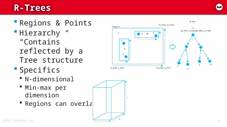
R-Trees
Regions & Points Hierarchy “Contains”
reflected by a Tree structure
Specifics N-dimensional Min-max per dimension Regions can overlap
©2015 Couchbase Inc. 13
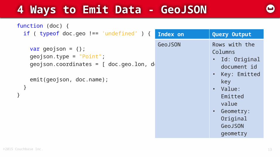
4 Ways to Emit Data - GeoJSONfunction (doc) { if ( typeof doc.geo !== 'undefined’ ) {
var geojson = {}; geojson.type = "Point"; geojson.coordinates = [ doc.geo.lon, doc.geo.lat ]; emit(geojson, doc.name); }}
Index on Query Output
GeoJSON Rows with the Columns • Id: Original
document id• Key: Emitted
key• Value: Emitted
value• Geometry:
Original GeoJSON geometry

©2015 Couchbase Inc. 14
4 Ways to Emit Data – Flat Arrayfunction (doc) { if ( typeof doc.geo !== 'undefined’ ) { var geojson = {}; geojson.coordinates = [ doc.geo.lon, doc.geo.lat ];
emit(geojson.coordinates, doc.name); }}
Index on Query Output
Array of coordinates/numeric values
Rows with the Columns • Id: Original
document id• Key: Emitted
key• Value: Emitted
value
©2015 Couchbase Inc. 15
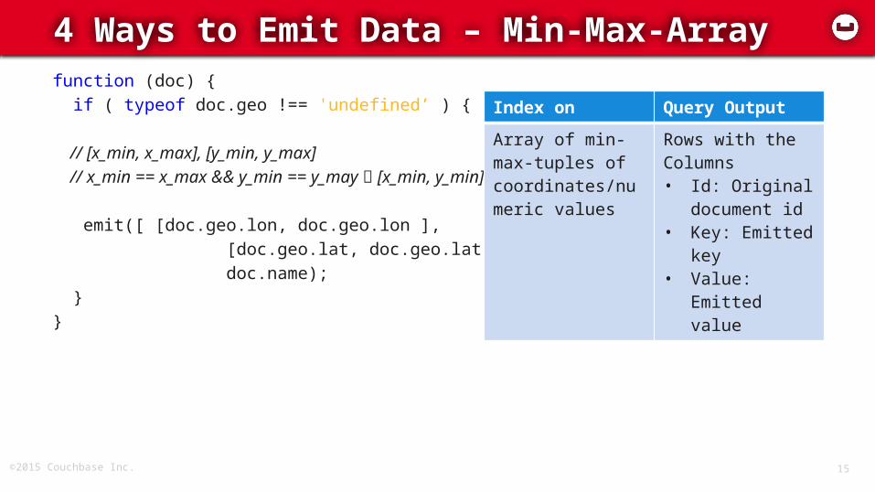
4 Ways to Emit Data – Min-Max-Arrayfunction (doc) { if ( typeof doc.geo !== 'undefined’ ) { // [x_min, x_max], [y_min, y_max] // x_min == x_max && y_min == y_may [x_min, y_min] emit([ [doc.geo.lon, doc.geo.lon ], [doc.geo.lat, doc.geo.lat] ], doc.name); }}
Index on Query Output
Array of min-max-tuples of coordinates/numeric values
Rows with the Columns • Id: Original
document id• Key: Emitted
key• Value: Emitted
value
©2015 Couchbase Inc. 16
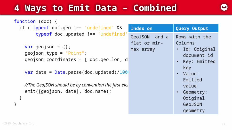
4 Ways to Emit Data – Combinedfunction (doc) { if ( typeof doc.geo !== 'undefined' && typeof doc.updated !== 'undefined') {
var geojson = {}; geojson.type = "Point"; geojson.coordinates = [ doc.geo.lon, doc.geo.lat ]; var date = Date.parse(doc.updated)/1000; //The GeoJSON should be by convention the first element emit([geojson, date], doc.name); }}
Index on Query Output
GeoJSON and a flat or min-max array
Rows with the Columns • Id: Original
document id• Key: Emitted
key• Value: Emitted
value• Geometry:
Original GeoJSON geometry

©2015 Couchbase Inc. 17
Creation via the UI

©2015 Couchbase Inc. 18
Querying via REST / Client SDK
http://$host/beer-sample/_design/dev_spatials/_spatial/by_region?stale=false&start_range=[-180,0,0]&end_range=[180,90,null]
start_range end_range limit skip stale

©2015 Couchbase Inc. 19
Example Output
total_rows
3452
rows
id key value geometry
boon_rawd_brewery
[[100.509,100.509],[13.7783,13.7783]]
{"brewery":"Boon Rawd Brewery”}
{"type":"Point","coordinates":[100.509,13.7783]}
Demo
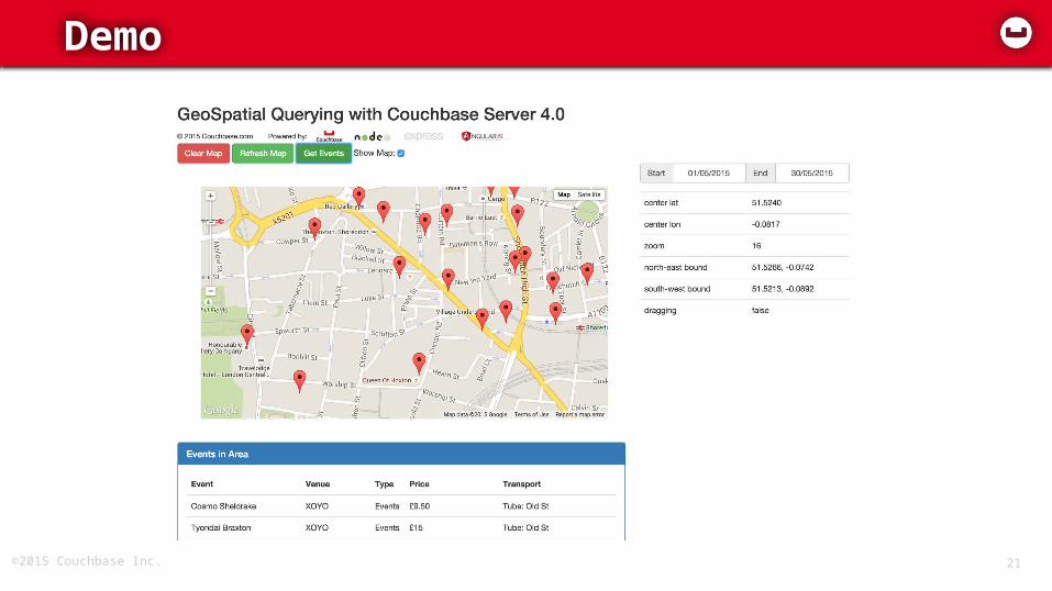
©2015 Couchbase Inc. 21
Demo

Thank you!Q&A