introduction 1. we take for granted the division of our planets surface into a collection of spaces...
TRANSCRIPT

Introduction1. We take for granted the division of our planets
surface into a collection of spaces2. Power is gained through connections among states
for economic reasons3. There were only about 50 countries in the 1940s; 192
today4. State – An area organized into a political unit and
ruled by an established government.5. Sovereignty – Independence from the control of its
internal affairs by other states6. Country – Synonym for state

Problems of Defining States1. Korea – one state or two?
a. Divided at 38 north after WW IIb. Democratic People’s Republic of Korea (north) invades the south in 1950c. Korean War lasts 3 years – border is the same as the beginning of the ward. Both Koreas want to reunite, agreed to family visits in 2000e. North Korea’s commitment to nuclear weapons?

Problems of Defining States
2. China & Taiwan: one state or two?a. According to China, Taiwan is not a sovereign stateb. Taiwan disputed this in 1999c. US recognized the Nationalist Party living in Taiwan as the real govt. until 1971d. Taiwan is the most populous state not in the UN

Problems of Defining States
3. Western Sahara or Sahrawi Arab Democratic Republic a. Considered by most Africans as a sovereign stateb. Morocco claims it and built a wall around it
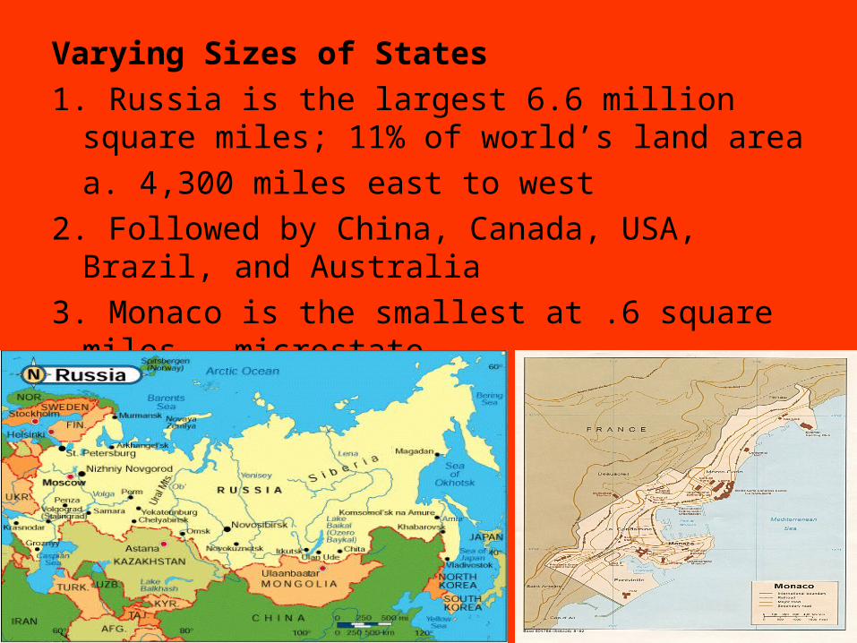
Varying Sizes of States
1. Russia is the largest 6.6 million square miles; 11% of world’s land area
a. 4,300 miles east to west
2. Followed by China, Canada, USA, Brazil, and Australia
3. Monaco is the smallest at .6 square miles – microstate

Development of the State Concept1. Idea develops in Europe but traced back to the
Fertile Crescent2. City-states had walls to clearly define border;
protected by countryside as well3. Rome would create 38 provinces using the
same laws as its capitala. Rome collapses due to attacks on the frontierb. Plus, Rome was fragmented among competing dukes, kings, barons, etc.

Colonialism1. To establish or impose political, economic, and cultural
principles on territorya. Promote Christianity, provide resources, indicator of powerb. Three Gs – God, Gold, Glory

Colonialism, cont.2. Europe turns to imperialism
of Africa after W. Hem declares independencea. UK would have a colony on every continentb. France would become the 2nd largest overseas territoryc. Germany colonized Africa to disrupt communications of their rivals


Colonialism, cont.3. France tried to assimilate colonies into their culture4. Britain used decentralization to preserve diversity5. As such, British transitions to independence were peaceful6. Most African and Asian colonies would become independent
after WW IIa. 15 before the war, 106 in 2007
7. The most populous remaining colony is Puerto Rico – can’t vote, no members of congressa. Least populated is Pitcairn Island (UK) – 47 people


Five Basic Shapes of States1. Compact – shorter distance from the
center to bordersa. Ideally shaped like a circle
with the capital at the centerb. Shorter boundaries to
defendc. Better communicationsd. Does not mean
peacefulnesse. Examples – Kenya,
Rwanda

ProruptedCompact state with large projecting region
a. Provide a resource to a country – Congo or Namibiab. Separate two states from sharing a boundary – Afghanistan

Elongated3. Long narrow shape
a. Creates isolation, poor communicationsb. Chile is 2,500 north to south and 90 miles east to westc. Gambia – 300 miles E-W, 15 miles N-S and surrounded by Senegal

Fragmented4. Several pieces of discontinuous areas
a. All states that have islands are fragmentedb. Indonesia has 13,677 islands across 3,000 milesc. Russia’s Kaliningrad is 250 miles away near Lithuaniad. Tin Bigha, India – corridor from India only measures 600 feet by 300 feet
1. Divided by Britain according to religione. Panama used to be fragmented until the canal was returned

Tin Bigha, India

Perforated5. A state that completely surrounds another
statea. South Africa surrounds Lesotho

Landlocked States
1. States surrounded by other states – no access to water
a. Africa – 14 of the 54 are landlocked
2. Access to the sea is critical for international trade
a. A state must arrange to use another country’s seaport
b. What if you disagreed with South Africa? Zimbabwe?
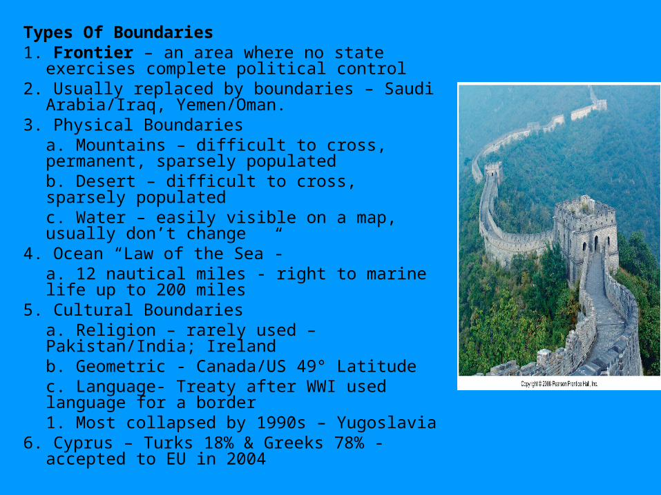
Types Of Boundaries1. Frontier – an area where no state exercises complete
political control2. Usually replaced by boundaries – Saudi Arabia/Iraq,
Yemen/Oman.3. Physical Boundaries
a. Mountains – difficult to cross, permanent, sparsely populatedb. Desert – difficult to cross, sparsely populated c. Water – easily visible on a map, usually don’t change
4. Ocean “Law of the Sea”- a. 12 nautical miles - right to marine life up to 200 miles
5. Cultural Boundaries a. Religion – rarely used – Pakistan/India; Irelandb. Geometric - Canada/US 49° Latitudec. Language- Treaty after WWI used language for a border
1. Most collapsed by 1990s – Yugoslavia6. Cyprus – Turks 18% & Greeks 78% - accepted to EU
in 2004

Boundaries Inside States1. Ethnicities in the minority may be content with control of a region2. Unitary State – power is in central government
a. Works best in a state with few conflicts & national unityb. Most multinational states use unitary to promote nationalism – China
3. Federal State – power distributed to local governmentsa. United States – adopt their own lawsb. Larger states – national capital may be to far away or isolatedc. Belgium – Flemings and Walloons
4. Poland – switched from unitary (communist) to federal a. Many elected didn’t the experience

Electoral Geography1. 435 US legislative boundaries
redrawn every 10 years for equal population
2. Gerrymandering – redrawing boundaries to benefit party in powera. Wasted Vote – gives one party a chance to win all districts (5-0)b. Excess Votes – concentrates opposition party into a few districts (4-1)c. Stacked Votes – oddly shaped boundaries – links like minded voters (3-2)
3. Recent gerrymandering has been Stacked – just gain a simple majority
4. Gerrymandering was ruled illegal in 1985 by the US Supreme Court

Utah U.S. Congressional Districts

Utah State House

Utah State House of Representatives

Utah House 25th District


Arizona U.S. District 2

Illinois 4th District

The United Nations
1. Created after WW II by the victorious Allies
a. Replaced League of Nations created after WW I
b. League could not stop aggression
c. US never joined even though their idea
2. 1945= 49 States; 2007 = 192
3. Rapid increase three times – 1955, 1960, early 1990s
a. 1955 – 16 countries – mostly European
b. 1960 – 17 countries – mostly former colonies in Africa
c. 1990s – 26 countries – end of communism and break up of Yugoslavia
4. Security Council – 5 permanent members
a. US, Russia, China, UK, France
b. Only takes one to veto peacekeeping missions
c. China, Russia, and France vetoed sending UN into Iraq in 2003
5. UN created a forum where all states of the world can meet w/o resorting to war

Regional Military Alliances
1. 1800s – eight superpowers – Austria, France, GB, Russia, Poland, Prussia, Spain, Sweden
2. Pre-WW I – superpowers were Germany, Italy, Japan, US replaced last 4
a. Post-WW II – US and Soviet Union
3. Large number of superpowers meant no one state could dominate = balance of power
4. Alliances were created to tip the balance of power = ally or satellite
a. Allies can be helpful or unreliable – use of airspace in US strike of Libya
5. US/Soviet Union used force to keep satellites in line
a. Hungary 1956, Czechoslovakia 1968, Afghanistan 1979
b. Dominican Republic 1965, Grenada 1983, Panama 1989
6. Satellites were used to set military bases to support conflicts abroad

Military Cooperation in Europe
1. NATO (North Atlantic Treaty Organization) 14 European countries + US, Canada
2. Warsaw Pact – communist states in Europe – defend each other if attacked
a. Used to stop anti communists in Hungary and Czechoslovakia
3. NATO – prevent Soviet Union from taking West Germany
4. Warsaw Pact provided buffer from a 3rd invasion from Germany
5. End of Cold War – NATO reduced, Warsaw Pact disbanded
a. NATO actually took on some Warsaw Pact countries

Economic Cooperation
1. The world has moved to a pattern of multiple superpowers
a. Economic power instead of military
b. Leading power is a union of states – European Union
2. 2004 – eight former communist states join EU
3. Goal – promote development through economic cooperation
4. Free trade – goods, services, capital, people move freely between members
5. Common currency – eliminated different prices, interest rates

Increase in Terrorism1. Aimed at ordinary people rather than military
targets
2. Pan Am Flight 103
3. 1993 World Trade Center
4. 1995 Oklahoma City
5. 1998 Tanzania and Kenya
6. 2000 USS Cole

September 11, 20011. United 93
2. al-Qaeda
3. Afghanistan – 2001
4. Iraq – 2003
5. Iran - ?

Supranationalism
1. Political, economic, and/or cultural cooperation among states to promote shared objectives
2. States tend to give up political power to a higher authority to pursue common objectives
a. Political, economic, military, or environmental goals
b. Ex. EU, NAFTA, UN NATO, Warsaw Pact, OPEC
Devolution
1. Granting of powers from central government to government at regional or local level
2. Regions within a state demand and gain political strength at the expense of the central government – breakup of a state - balkanization
3. Growing autonomy within a state
a. Ex. Yugoslavia, USSR, Czechoslovakia, British India
b. UK, Canada, Spain, India/Pakistan