introduction - home - city of orlando
TRANSCRIPT

SOUTHEAST ORLANDO SECTOR PLAN
DEVELOPMENT GUIDELINES AND STANDARDS
MAY 10, 1999 • 1
INTRODUCTION
The primary intent of these design guidelines and standards is to create a sustainable and balanced communityin Southeast Orlando with the characteristics of traditional “Orlando”: where streets are convenient and com-fortable for walking, where parks are a focus for public activity, and where the life and vitality of a mid-sizedtown can be enjoyed by its residents and visitors.
A full range of uses, services, amenities, and activities are planned in Southeast Orlando to fill the needs of theultimate population of roughly 65,000. Along these lines, a hierarchy of places has been proposed, ranging froma Town Center that will serve as one of the primary destination and job centers within the community, to Villageand Neighborhood Centers that provide local shopping and civic spaces for Residential Neighborhoods, toAirport Support Districts that include a variety of industrial, office, and supportive commercial uses.
The size of Southeast Orlando, as well as the coordinated effort underway to plan for the area, provide anopportunity to create a unique image and character that is immediately identifiable to visitors and residents.Like some older communities, Southeast Orlando should be immediately identifiable by the pattern of residen-tial districts that focus on village and neighborhood centers; by the design of homes and commercial buildings;by the trees planted along major boulevards and the scale of local streets; and by the proximity to nature. Thesedesign guidelines and standards establish a framework for such a community to evolve.
PLANNING PRINCIPLES
Establish an Identifiable Regional Edge and Infill with Urban Development
Virtually all of the Orlando region is surrounded by environmentally sensitive lands. Though some growth hasalready hopscotched beyond this natural edge, the majority of the region is defined by the regional system ofdrainageways and protected habitat. In areas where growth is progressing, regulatory efforts or strategic landpurchases can help to create and reinforce an identifiable regional edge and help to limit urban sprawl.
Conversely, the majority of regional growth should be directed to developable lands within the urban area.Funding for roads, infrastructure, services, and schools should support compact development patterns.
The Southeast area represents a substantial new growth area which should be planned and developed withthese principles in mind.
Plan a Community, Not a Bedroom Suburb
The 19,300 acres represented by the Southeast Orlando area is the size of a mid-size town. A full range of uses,services, amenities, and activities should be planned to fill the needs of the new Southeast Orlando citizens.Along these lines, a hierarchy of places has been proposed, ranging from a Town Center that will serve as the“downtown” for the community, to Village and Neighborhood Centers that provide local shopping and civicspaces for Residential Neighborhoods, to Airport Support Districts that include a variety of job-generating uses.Each of the centers will take on their own identity over time. For example, one center may focus on retail andentertainment, another on business, and another on civic uses.
Reinforce Linkages to Regional Activities
The Orlando International Airport is a strong and growing economic engine within the region. The GreaterOrlando Airport Authority, GOAA, plans to construct a fourth runway, expand terminal facilities, build new on-site roadways, pursue regional rail transit linkages, and actively market airport-related industrial, office andcommercial development.

SOUTHEAST ORLANDO SECTOR PLAN
DEVELOPMENT GUIDELINES AND STANDARDS
2 • INTRODUCTION
The Southeast Orlando area is directly adjacent to this significant regional center and has the potential to benefitby serving as a prime location for new office and industrial development. In addition, the Southeast Orlandoarea’s location can capitalize on traffic to the airport through strategically placed commercial/lodging activities,and by providing a full range of housing that is both affordable and convenient for airport employees.
Similarly, the Southeast Orlando area is also within a 10 to 20 minute driving distance of many of the region’sentertainment attractions, as well as other regional job and education centers. The mix of uses and housingtypes within the Southeast Orlando area should strengthen these linkages and fill market niches to the greatestextent possible.
Protect and Strengthen Primary Ecological Systems
Southeast Orlando is situated between two regionally significant systems: the Econlockhatchee River (The Econ)and Boggy Creek. The site itself includes portions of two major drainage basins (Boggy Creek and Lake Hart),a connected system of lakes and small water bodies, high concentrations of wetlands, and a great diversity ofplants and wildlife, many of which are protected by the City’s GMP Conservation Element as well as Federaland State regulations. Though much of this habitat forms contiguous corridors, some areas have been alteredby roadways, agricultural conversion, ditching, and cattle grazing.
An opportunity exists in the Southeast Orlando area to create a permanently protected ecological system that isboth regionally significant and maintains the integrity of on-site drainage and wildlife corridors. Envisioned asa Primary Conservation Network, or PCN, this area can also become a “mitigation bank” that allows smallerwetland areas outside the network to be transferred to areas of increased importance and viability. As thePrimary Conservation Network becomes the mitigation receiving zone, gaps in the system could be recaptured,helping to reinforce the overall integrity of this ecology. Careful siting of trails, parks, and ponds would alsoallow the PCN to serve as an integrated community amenity.
Create Identity and Sense of Community
Identity and community are often lost in the faceless growth of many suburban areas. Typically, each developerworks on a separate track to build and market their property. Public facilities and civic spaces are often placedon the left over, least expensive land. The result is a disjointed series of subdivisions, rather than a communityof people and places.
The size of the Southeast Orlando area, as well as the coordinated effort that has been put forth and will con-tinue in planning for the area, provide an opportunity to create a unique image and character that is immedi-ately identifiable to visitors and residents. Like some older communities1, Southeast Orlando should be imme-diately identifiable by the trees planted along major boulevards and the scale of local streets2; by the pattern ofresidential districts that focus on village and neighborhood centers; by the design of homes and commercialbuildings; and by the proximity to nature.
A sense of community can be nurtured through the town’s physical structure. Each residential district shouldbe scaled to the pedestrian, making casual interactions among neighbors possible. Schools and parks should befocal points for neighborhood activities, rather than anonymous institutions and large no-man’s lands. Com-mercial districts should integrate public facilities and spaces, creating a civic atmosphere typical of more tradi-tional downtowns.
1 Winter Park has been suggested as a good example of a community that has a distinct identity.2 The landscape improvements to Narcoosee Road are an important first step in developing an identity for the com-
munity.

SOUTHEAST ORLANDO SECTOR PLAN
DEVELOPMENT GUIDELINES AND STANDARDS
MAY 10, 1999 • 3
Develop a Model Small School System Based on Innovation and Excellence
For Southeast Orlando to grow in a competitive and community-oriented manner, a new approach to the schoolsystem must be considered. Large schools that force children into an anonymous setting and require parents tobecome chauffeurs, inevitably work against our goal to create a sense of community.
Small schools give children the attention they need to build a sense of identity and self-esteem. Schools that arewithin a short walk of most homes help to nurture neighborhood pride. Schools that build innovative linkagesto local industries and educational institutions bring the hope of reestablishing a commitment to educationexcellence and building a long-term future for the next generation.
A coordinated schools strategy should be prepared for Southeast Orlando area that addresses school size, fund-ing, phasing, and management.
Build to Support Transit, Walking and Bicycling
Pedestrian travel is the basic building block for developing a balanced transportation system. Streets will pro-vide direct connections to local destinations, such as Village and Neighborhood Centers. These trips should notrequire driving onto the arterial network or the freeway system. The mix of uses at commercial centers shouldencourage “trip linking” so that several errands can be accomplished in one stop. In addition, travel withinneighborhoods should be distributed among several “connector streets” that lead to local parks, schools, andcommercial centers. High volume collector streets that divide neighborhoods and discourage walking or bicy-cling should not be permitted. A goal of the planning effort is to create a plan with no arterials larger than fourlanes – an interconnected local and connector street system will help achieve this goal.
Neighborhood streets must be safe for children, comfortable for bicycling, and pleasant to walk along. Narrowand tree-lined streets should be lined with building entries and living spaces so that residents can know theirneighbors and keep streets safe. Traffic calming is an essential ingredient for creating a pedestrian and bicyclefriendly street network. In order for an interconnected street network to provide desirable residential environ-ments, streets widths and corner curb radii should be as small as possible, while providing for legitimate safetyand emergency vehicle considerations. Curb and gutter design, street lighting, park strips, and street trees areimportant aspects of townscape and should reflect the unique character of individual neighborhoods.
The possibility of local rail service using the existing OUC rail line should also be considered over time. In theinterim, transit service to Southeast Orlando will be limited to Lynx bus service. Stops should be located atvillage and neighborhood centers to provide a centrally-located connection within walking distance of mosthomes. Rail service, most likely an extension of an airport connection, is a long term prospect that has thepotential to link Southeast Orlando’s Town Center to other regional destinations.
Ensure that the Plan is Implementable
While the intent of the Southeast Orlando Sector Plan is to create a visionary approach to building a new com-munity, the plan is also grounded in practicality. This will aid in the smooth implementation of the plan overtime. A potent yet flexible framework makes the Plan capable of transcending time and changing market condi-tions.

SOUTHEAST ORLANDO SECTOR PLAN
DEVELOPMENT GUIDELINES AND STANDARDS
4 • INTRODUCTION
THE SOUTHEAST ORLANDO MASTER PLAN
The Southeast Orlando Sector Plan establishes a comprehensive development framework for this growing re-gion in central Florida. The Southeast Orlando Sector Plan - Master Plan Map works in conjunction with theDesign Guidelines and Standards to visually illustrate the concepts of the overall planning effort. The MasterPlan Map provides a tool for public and private parties to approach the physical structure and building of thisnew community. The Master Plan Map shows locations of major natural and ecological features; existing andproposed highways and roads; proposed locations for Town, Village, and Neighborhood Centers; as well asvarious land uses proposed within the study area.
While the locations of many of the elements in the plan are conceptual, the number and relative size of the usesare should be seen as accurate. For example, the location of schools may vary slightly within each neighbor-hood, however, the individual number of elementary, middle, and high schools is accurate for the expectedpopulation of the entire study area.
How to Use These Guidelines and StandardsThis Illustrated Guidebook provides a comprehensive summary of the guidelines and standards which per-tain to the Southeast Orlando Sector Plan. However, this Illustrated Guidebook is not an officially adopteddocument. The City’s Growth Management Plan and Chapter 68 of the Land Development Code provide thespecific policy and land development standards applicable to the Southeast Plan area. Where conflicts exist,the adopted GMP and LDC Chapter 68 shall prevail.
Applicants are encouraged to familiarize themselves with the pertinent GMP goals, objectives and policies whichaffect the Southeast Orlando Sector Plan area (Future Land Use Policy 2.4.4, Goal 4 and associated objectivesand policies). In reviewing projects in the Southeast Plan area, applicants shall review the appropriate GMPgoals, objectives and policies, the Future Land Use Map and the Zoning Map, before attempting to determinehow these guidelines and standards shall be applied.
INTERPRETATIONShall; Should; May; IncludesThe words “shall” or “must” are mandatory; the word “should” is directive but not necessarily mandatory; theword “may” is permissive. The word “includes” shall not limit a term to the specific examples, but it intendedto extend its meaning to all other instances and circumstances of like kind or character.
ConflictsThe particular shall control the general. In case of any difference of meaning or implication between the text ofand/or any caption, figure, illustration, summary table, or illustrative table presented in this Illustrated Guide-book and the officially adopted LDC Chapter 68, the text of Chapter 68 shall control.
Interpretation of Undefined TermsTerms not otherwise defined herein shall be interpreted first by reference to the City’s GMP, if specifically de-fined therein; second, by the City of Orlando LDC; third, by the Congress of the New Urbanism Lexicon; andfourth; by reference to generally accepted engineering, planning, or other professional terminology if technical;and otherwise according to common usage, unless the context clearly indicates otherwise. Specific definitionsare presented at the end of this Illustrated Guidebook.

SOUTHEAST ORLANDO SECTOR PLAN
DEVELOPMENT GUIDELINES AND STANDARDS
MAY 10, 1999 • 5
Replace This Page (5) with Color Master Plan Map,Page 6 Left Intentionally Blank

SOUTHEAST ORLANDO SECTOR PLAN
DEVELOPMENT GUIDELINES AND STANDARDS
6 • GMP POLICY FRAMEWORK
Growth Management Plan Policy FrameworkThe City’s Growth Management Plan Future Land Use Element has been amended to address the developmentof the Southeast Orlando Sector Plan area. Following are the pertinent goals, objectives and policies whichrelate to Southeast Orlando.
Future Land Use Element Policy 2.4.4 (Establishes the Urban Village Concept)In order to encourage long term sustainable development practices, the Urban Village future land use designa-tion shall be encouraged and applied to the Future Land Use Map to designate areas subject to an integratedplanning process. The application of an Urban Village future land use designation shall reflect the use of plan-ning practices which ensure neighborhoods and communities contain a mixture of land uses that fully promotesmulti-modal development options, ensures a realistic jobs-housing balance, provides housing opportunitiesreflective of the community at large, protects and enhances sensitive environmental areas and incorporatestraditional community building practices. The Urban Village future land use designation may include compat-ible land uses other than those specifically listed as allowable in Figure LU-1.
The Urban Village future land use designation provides for a mixture of land uses and intensities within adevelopment site in order to preserve conservation areas, to reduce public investment in provision of services,to encourage flexible and creative site design and to provide sites for schools, recreation and other public facili-ties which provide an area-wide benefit to the community. The Urban Village future land use designation isspecifically intended to provide a means of streamlining the development review process where a Developmentof Regional Impact (DRI) and DRI Development Order, a Sector Plan, and/or Master Plan, have already fullyaccounted for the impacts of development. The designation shall be structured to ensure that the Urban Villageand the individual components of the Urban Village are compatible with existing or projected surrounding landuses, taking into consideration environmental constraints, health and safety issues, and the appropriatenessand potential impact of the Urban Village on adjacent existing and future land uses.
In order to encourage innovative land use techniques, creative urban design, environmental protection, and thejudicious use of sustainable development principles and practices, the following areas may be designated withthe Urban Village designation on the Official Future Land Use Map: projects within the Southeast OrlandoSector Plan area provided the project’s master plan and actual development complies with the Southeast Or-lando Sector Plan - Conceptual Master Plan Map (Figure LU-2A), Future land Use Goal 4 and associated objec-tives and policies, and applicable development standards; projects within a previously approved Developmentof Regional Impact; projects within an approved Sector Plan as may be defined in Chapter 163 and Rule 9J-5;and areas such as the Orlando Naval Training Center, where future land use designations and associated im-pacts have been reviewed and approved through a comprehensive and integrated planning process.
In order to obtain the Urban Village future land use designation, the applicant shall initiate a Growth Manage-ment Plan amendment that includes one or more subarea policies which provide structure and detailed devel-opment criteria for each individual project. The subarea policy shall address, at a minimum, the followingitems: (1) fundamental community design principles, standards and guidelines; (2) allowable uses and compo-sition of mix; (3) overall intensities and densities for each Urban Village, and where applicable, for each land usecomponent of the Urban Village; and (4) minimum transportation requirements to ensure maximum connectiv-ity and appropriate access.
The Urban Village future land use designation shall appear on the Official Future Land Use Map as a subareapolicy boundary, with either future land use designations, land use classifications, or references to site specificmaster plans or other land use identification techniques consistent with the specific subarea policy establishingthe Urban Village. Allowable use types may be shifted within the Urban Village future land use designation orindividual components of the Urban Village through an amendment to the project master plan, so long as thechange is consistent with the standards and criteria specified in the pertinent adopted subarea policy. For DRIs,uses may only be shifted in conformance with an approved DRI equivalency matrix and the applicable GMPsubarea policy, where applicable.
SOUTHEAST ORLANDO SECTOR PLAN
DEVELOPMENT GUIDELINES AND STANDARDS
MAY 10, 1999 • 7
Higher densities and intensities may be applied on specific building sites within each component of the UrbanVillage designation, provided that the relationship to surrounding properties is enhanced through strong pe-destrian linkages, appropriate consideration of scale and streetscape, and gross densities and intensities of theentire Urban Village remain within the range of densities/intensities specified in the required subarea policy.
The City shall designate environmentally sensitive lands within the boundaries of the Urban Village as Conser-vation Use, Resource Protection Overlay, and/or Transitional Wildlife Habitat Overlay, consistent with the goals,objectives and policies of the City’s Growth Management Plan. In addition, all environmentally sensitive landsidentified in an Application for Development Approval (ADA) and/or DRI Development Order/Map H asConservation, Preservation, or Mitigation, shall be designated Conservation Use on the City’s Official FutureLand Use Map. Any proposed shifting of land uses shall not result in additional significant and adverse impactson environmentally sensitive lands as identified on the Official Future Land Use Map and in the ConservationElement.
Impact Study. For any proposed change to an Urban Village which would increase the maximum developmentcapacity, the applicant shall be required to provide an analysis to determine whether the projected traffic asso-ciated with the change has significant and adverse impacts on the surrounding road network as defined inChapter 380, F.S. Any such proposed change which results in greater off-site impacts or potential significantand adverse impacts on adjacent land uses or the surrounding roadway network, shall be reviewed to deter-mine consistency with the Growth Management Plan and to determine if a Plan amendment is necessary.
Implementation of the Urban Village future land use designation shall be through a DRI Development Order, ifapplicable and sufficiently specific; the required subarea policy; and rezoning to Planned Development (PD) asdefined in the City’s Land Development Code. Each Development Order and/or PD zoning ordinance shall beconsistent with the pertinent subarea policy and include an appropriately detailed master plan and develop-ment guidelines.
Growth Management Plan Amendments. New development inconsistent with the applicable subarea policy (or inthe case of the Southeast Orlando Sector Plan area, Future Land Use Goal 4 and associated objectives and poli-cies) shall not be allowed to occur until after a GMP amendment is made effective. At a minimum, a GMPamendment shall be required when: (1) a proposed change would be in direct conflict with the fundamentalcommunity design principles, standards and guidelines specified in the adopted subarea policy; or (2) a pro-posed change includes a principal land use not specified in the adopted subarea policy; or (3) the proposedchange would be in conflict with the overall intensities and densities specified in the adopted subarea policy, or(4) the proposed change would be in conflict with the minimum transportation connectivity and access require-ments specified in the adopted subarea policy.
Urban Village/Planned Development (PD) Zoning Ordinance Amendments. Alterations to an approved Urban Vil-lage PD shall be classified as either substantial or non-substantial, and if substantial shall require an amendmentto the PD zoning ordinance. The following criteria shall be used to identify a substantial amendment: (1) achange which would include a principal land use not previously permitted under the approved PD zoningordinance and/or applicable GMP subarea policy(ies); (2) a change which would alter a land use type adjacentto a property boundary, except where it is (i) a reduction in density or (ii) a reduction of intensity or approvedresidential development, unless the reduction locates a residential use adjacent to an incompatible land use; (3)an alteration which would increase the size of an Activity Center, Town Center, Village Center, of NeighborhoodCenter; (4) a proposed change which would increase the land use intensity within the Urban Village PD withouta corresponding decrease in some other portion of the PD and which results in greater off-site impacts or poten-tial significant and adverse impacts on adjacent land uses of the surrounding roadway network.
Any proposed alterations to the Urban Village PD shall be reviewed on a case-by-case basis to determine whetherthe alteration is substantial, and to determine if a change to the PD zoning ordinance is necessary. The determi-nation of a substantial or non-substantial alteration shall be made jointly by the City Planning Official andPlanning and Development Director. If an applicant disagrees with the Planning Official/Planning Directordetermination, the issue may be presented to the Muncipal Planning Board and ultimately the City Council forresolution.

SOUTHEAST ORLANDO SECTOR PLAN
DEVELOPMENT GUIDELINES AND STANDARDS
8 • GMP POLICY FRAMEWORK
Alterations to the Urban Village PD determined to be substantial must submit plans and support data as speci-fied in the Land Development Code for review by the Municipal Planning Board with a public hearing for finalaction by the Orlando City Council.
Alterations necessary to accurately reflect the location of schools, parks, libraries, public safety facilities or othersmall scale public facilities shall be considered non-substantial. All nonsubstantial alterations to an Urban Vil-lage PD, except those specified in the PD zoning ordinance as a minor administrative modification, must besubmitted and approved by the City Planning Official and Planning Director through administrative review.
The provisions specified in this policy and/or future subarea policies related to individual Urban Villages shallwork in conjunction with all other applicable GMP objectives and policies and shall not supercede such policies.In all land use categories, the Planned Development (PD) zoning classification shall be encouraged, and mayinclude, as secondary uses, compatible land uses other than those specifically listed as allowable in Fig. LU-1.
Policy 2.4.11 (Introduces Aircraft Noise/Land Use Control Concepts)The City of Orlando shall cooperate with the Greater Orlando Aviation Authority in its efforts to implement theAircraft Noise and Land Use Control Zone Map concept, along with associated noise control/sound level re-duction standards. Following notice to City property owners and public hearing as deemed acceptable to theCity, the City shall consider amendment of this policy to adopt the Aircraft Noise and Land Use Control ZoneMap concept, or such other map deemed acceptable to the City, along with associated noise control/sound levelreduction standards. Upon such amendment to this policy, the City shall consider the adoption of processes forpublic disclosure of potential noise impacts, and avigation easement and waiver requirements in the Land De-velopment Code. It is anticipated that the following aircraft noise attenuation standards may be adopted as afuture amendment to this policy, on a City-wide basis:
Sound Level ReductionSingle Family Prohibited in Zones A and B Multifamily Prohibited in Zones A and B
SLR 35 Reduction in Zone C SLR 30 Reduction in Zone CSLR 30 Reduction in Zone D SLR 25 Reduction in Zone DSLR 20 Reduction in Zone E Permitted in Zone E
Hotel SLR 35 Reduction in Zone A Hosp’l/Clinic Prohibited in Zones A and BSLR 35 Reduction in Zone B SLR 30 Reduction in Zone CSLR 30 Reduction in Zone C SLR 25 Reduction in Zone DPermitted in Zones D and E Permitted in Zone E
Childcare Prohibited in Zones A and B Schools Prohibited in Zones A and BSLR 30 Reduction in Zone C SLR 30 Reduction in Zone CSLR 25 Reduction in Zone D SLR 25 Reduction in Zone DPermitted in Zone E Permitted in Zone E
1. While residential uses are permitted in Aircraft Noise Control Zone C, they are not encouraged.2. Childcare facilities in Zone C shall only be permitted as an accessory uses. Stand-along childcare
facilities shall be prohibited. Existing childcare facilities shall be permitted to expand so long asnew structures meet the noise attenuation standards listed above.
3. Elementary, Middle, and High School facilities, whether public or private, shall be prohibitedin Zone C. Other school facilities shall be reviewed as a Conditional Use, in which the SLRreduction specified above and additional land use compatibility standards would apply.
Upon the amendment of this policy, and thereafter until specific requirements are adopted into the City’s LandDevelopment Code, appropriate public disclosure notice may be required and/or applied on a project by projectbasis within Aircraft Noise Control Zones A through F. In addition, at such time, the City may require avigationeasements and/or waivers as appropriate on a project-by-project basis within Aircraft Noise Control Zones Athrough D.

SOUTHEAST ORLANDO SECTOR PLAN
DEVELOPMENT GUIDELINES AND STANDARDS
MAY 10, 1999 • 9
Subarea Policies S.34.2 and S.35.4The properties within the boundary of this Subarea Policy area located within the Southeast Orlando SectorPlan area. The provisions specified in Future Land Use Policy 2.4.4, Goal 4 and associated objectives and poli-cies shall apply within this area.
Subarea Policy S.35.3One Village Center/Urban Transit Center may by permitted north of Lake Nona (the lake) and west of NarcoosseeRoad in the future, as part of an individual master plan submission. The Center shall not be located withinAircraft Noise Control Zones A-D, but shall be permitted in Aircraft Noise Control Zone E. This Village Center/Urban Transit Center designation may be established within an Urban Village PD in conformance with Policy2.4.4. If not established as part of an Urban Village PD, a Growth Management Plan amendment shall be re-quired.
Subarea Policy S.38.1The Poitras property, currently under the control and ownership of the City of Orlando/Greater Orlando Avia-tion Authority, shall be held in reserve for future urban development until such time as adequate infrastructureis made available, and market conditions clearly indicate the need for additional urban land. Permitted usesunder the current Urban Reserve future land use designation shall include Single Family Residential at a den-sity of 1 dwelling unit per 10 acres, Agriculture, Conservation Uses, Stormwater Facilities, Borrow Pits andUtility Facilities. Conditional Uses shall include Golf Course and Public Benefit Uses/Park. Borrow pits shallbe permitted upon receipt of a South Florida Water Management District Permit. A Growth Management Planamendment will be necessary in order to apply urban land uses to the subject property. Any change in land usewithin this area shall be conducted in accordance with provisions of Chapter 163, including Sections 163.3184,163.3187, 163.3189, F.S; Rule 9J-5.005 (2 and 8); Rule 9J-11, F.A.C., and the applicable goals, objectives and poli-cies of the City’s Growth Management Plan. In addition, future urban development within this area shall besubject to the standards established in the Southeast Orlando Sector Plan.
FUTURE LAND USE GOAL 4The City recognizes the importance of the Orlando International Airport (OIA) to the state and regionaleconomy, particularly in regards to commerce, and the tourism and convention industries. As the only majorairport in the State with the potential for expansion, the OIA is an essential component of Orlando’s contin-ued economic development. Because the airport’s role in the regional and state economy is so vital, the Cityof Orlando is dedicated to the continued growth of airport facilities, and to the planned growth of thosesurrounding areas which provide support to, and are supported by, the airport.
Objective 4.1In order to implement the Southeast Orlando Sector Plan, the City shall process and adopt appropriate GrowthManagement Plan amendments, rezones, and amendments to the Land Development Code, by 1999. Strategiesfor creating a sustainable development pattern shall by incorporated into the Growth Management Plan andLand Development Code amendments. Such strategies shall emphasize the provision of adequate infrastruc-ture services, the protection of environmentally sensitive lands and other natural resources, and a developmentframework featuring sustainable TRADITIONAL DESIGN principles.
Policy 4.1.1The City shall encourage the steady growth of aviation facilities, and associated, supportive high-technologyindustries in the vicinity of the Orlando International Airport, in order to successfully compete wtih other grow-ing cities in the southeastern United States, and to capture Orlando’s “fair-share” of economic opportunity.
Policy 4.1.2Because the Southeast/Orlando International Airport Future Growth Center currently contains a large employ-ment population, one that will continue to grow well into the future, a mixture of urban land uses and develop-ment opportunities must be provided in order to serve that population. A mixed use community is desirable inthis area because of its proximity to the Orlando International Airport. Therefore, Planned Development shallbe encouraged, including a mixture of residential uses types, hotel, commercial, office, industrial, conservation,and recreational uses.

SOUTHEAST ORLANDO SECTOR PLAN
DEVELOPMENT GUIDELINES AND STANDARDS
10 • GMP POLICY FRAMEWORK
Policy 4.1.3The City of Orlando shall review, and where appropriate, revise the density and intensity bonus system foundin the Land Development Code in order to encourage a functional mixture of land use types in the Southeast/Orlando International Airport Future Growth Center area.
Policy 4.1.4The City shall allow limited transfer of development rights for the purpose of clustering residential and non-residential development and protecting important natural resources and environmentally sensitive lands, asstipulated in Conservation Element Policy 1.4.6. In addition to allowing density transfers within a developmentsite, the City shall examine the feasibility of an expanded transfer of development rights system that wouldallow density transfers between development sites in the Southeast/Orlando International Airport Future GrowthCenter area. In addition to the Southeast/Orlando International Airport Future Growth Center area, similartransfer of development rights provisions shall be considered for other compact and related areas.
Policy 4.1.5The City’s activity center concept, which provides for concentrations of urban densities and intensities, is de-signed to limit urban sprawl. The City recognizes that the benefits of a concentrated urban form include effi-ciencies related to public services, neighborhood protection, energy consumption, and environmental protec-tion. The City shall conscientiously plan for the growth of the Southeast/Orlando International Airport FutureGrowth Center, and will ensure that adequate facilities and services to serve this fast-growing urban area areavailable and financially feasible.
Policy 4.1.6 (This represents a key policy, which states the overall land use and design vision for the South-east Orlando Sector Plan)The Southeast Orlando Sector Plan area shall accommodate approximately 13,300 residential units, 2.1 millionsquare feet of retail, 3.3 million square feet of office, 1,950 hotel rooms, 4.7 million square feet of industrial space,and 600,000 square feet of civic/government space by the year 2020. In order to build a sustainable communityin the Southeast Orlando Sector Plan area, development shall conform to a land use plan which promotes apositive jobs-housing balance recognizing the presence of the Orlando International Airport, provides for anintegrated mixture of land uses featuring diverse residential uses and centrally located non-residential culturaland civic uses, and provides for increased accessibility and interconnectedness through an integrated multi-modal transportation system, featuring a strong pedestrian environment and network.
It is the City’s intention that the percentage of multi-family units within the Plan area shall not exceed 40%. Ingeneral, this standard will be applied on a project-by-project basis. However, the City may allow more multi-family units within individual projects if there is a preponderence of single family development in an adjacentarea.
This land use plan will integrate urban activity with appropriate environmental protections, providing oppor-tunities for social interaction within the context of an integrated amenity framework. This plan shall be imple-mented through land development regulations which enhance the advantages of the Orlando InternationalAirport and utilize TRADITIONAL DESIGN concepts to create a hierarchy of places ranging from a Town Cen-ter that will serve as a primary destination and job center within the community, to Village and NeighborhoodCenters that provide local shopping and civic spaces for residential areas, to airport-related employment dis-tricts that include a variety of industrial and office uses and employment opportunities, to prominently locatedpublic uses. In the Southeast Orlando Sector Plan area, mixed use centers and residential neighborhoods shallbe compact, walkable, and interconnected, and residential neighborhoods shall be defined by diverse and inte-grated housing opportunities, easily accessible public space and activated by locally oriented civic and commer-cial facilities. The City shall promote design concepts that provide a strong connection between nature and thebuilt environment, and shall pursue an innovative and comprehensive approach to stormwater control by inte-grating these facilities with parks and open space, pedestrian and bicycle pathways, and wetland protection/wildlife corridors. The City shall encourage the use of Crime Prevention Through Environmental Design tech-niques throughout the Southeast Orlando Sector Plan area.

SOUTHEAST ORLANDO SECTOR PLAN
DEVELOPMENT GUIDELINES AND STANDARDS
MAY 10, 1999 • 11
Policy 4.1.7Figure LU-2A presents the Southeast Orlando Sector Plan Conceptual Master Plan, or Southeast Plan map. Thismap shall appear in the Future Land Use Element Support Document and shall be used to guide developmentwithin the Southeast Orlando Sector Plan area. The City Planning Official shall be authorized to revise FigureLU-2A to reflect changes approved through the Urban Village future land use process specified in Policy 2.4.4,following a determination that the proposed alteration is compatible with the intent of the Southeast OrlandoSector Plan, and the subarea policies which define the Urban Village future land use designated areas. Anychange to properties outside an Urban Village future land use designation shall require an amendment to theOfficial Future Land Use Map, and an amendment to Figure LU-2A.
Policy 4.1.8 (Key policy; establishes the basic framework for the application of the future land use categoriescreated for the Southeast Orlando Sector Plan and the supporting TRADITIONAL DESIGN concepts)Development in the Southeast Orlando Sector Plan area shall be encouraged to incorporate sustainable land usetechniques and principles which ensure a strong local economy, produce communities of diverse livable neigh-borhoods, and conserve and protect the fragile natural and built environment. The Town Center/Urban TransitCenter, Village Center/Urban Transit Center, Village Center, Neighborhood Center and associated ResidentialCenter future land use categories shall be applied singularly and together to ensure:
(a) development in the form of coherent and compact interconnected districts and neighborhoods withclearly defined centers and edges and a diverse mix of activities (residences, shops, schools, workplacesand parks, etc.) located to minimize the use of the automobile.(b) mixed and multiple use integrated districts providing residential and employment opportunitiesand variety of shops, services, restaurants, and civic activities that serve the needs of surrounding neigh-borhoods.(c) diverse, compact (typically no more than one quarter mile from center to edge) neighborhoods whichencourage pedestrian activity.(d) neighborhoods with a wide spectrum of housing options which enable people of a broad range ofincomes, ages, and family types to live within a single neighborhood or district. Large developmentsfeaturing a single use or serving a single market segment are discouraged.(e) a balanced transportation system providing equal emphasis to transit, pedestrian, and bicycle mo-bility to reduce the reliance on automobiles. Streets laid out as an interconnected network, formingcoherent blocks where building entrances fron the street rather than parking lots. Provision of bicycle/pedestrian connections as necessary to directly connect to nearby uses. Public transit available to con-nect neighborhoods to each other, and the surrounding region.(f) the celebration of public space. Civic buildings, such as government offices, community or neighbor-hood centers, churches and libraries should be sited in prominent locations, which are accessible to thepedestrian. Open spaces, such as parks, playgrounds, squares, and greenbelts should be located ataccessible locations throughout a neighborhood.(g) Cohesive urban design which builds civic pride, enhances community identity and reinforces theculture of democracy.
The City shall utilize the Growth Management Plan policies, the Urban Village future land use designation, andthe Land Development Code to further implement these concepts.
Policy 4.1.9 (Key policy; establishes the future land use designations and standards that will apply in theSoutheast Orlando Sector Plan area)Properties within the Southeast Orlando Sector Plan area may utilize the future land use designations providedin this policy or the Urban Village designation provided under Policy 2.4.4. Projects that utilize the UrbanVillage designation shall be developed under the Planned Development (PD) zoning classification, as specifiedin the City’s Land Development Code. This process shall provide for continuing public input into the planningprocess.
Projects that utilize the future land use designations provided in this policy without the Urban Village futureland use designation, shall conform to the Southeast Orlando Sector Plan - Conceptual Master Plan Map (FigureLU-2A). Any change to an individual project Master Plan which is inconsistent with Figure LU-2A shall only beallowed following the approval of a Growth Management Plan future land use map amendment.
SOUTHEAST ORLANDO SECTOR PLAN
DEVELOPMENT GUIDELINES AND STANDARDS
12 • GMP POLICY FRAMEWORK
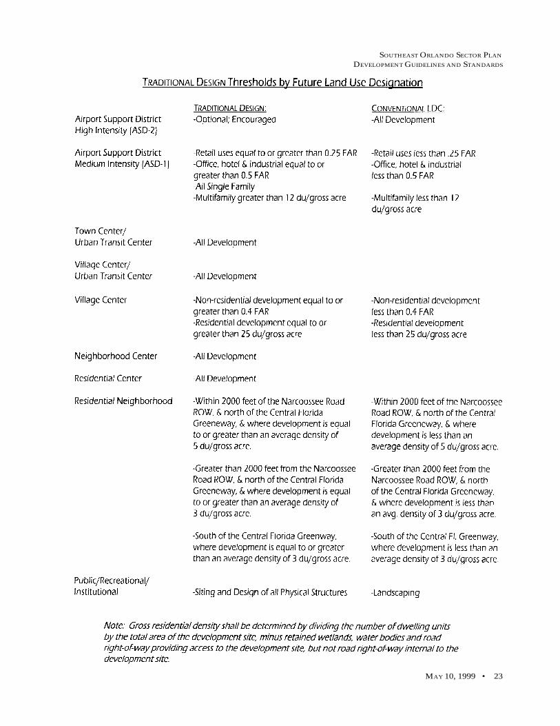
The Southeast Orlando Sector Plan allows the use of CONVENTIONAL LDC Standards (see below) undercertain conditions. As an alternative, property anywhere within the Southeast Orlando Sector Plan area may bedeveloped in accordance with TRADITIONAL DESIGN planning principles (see below), and the incentivesassociated with such planning principles as a matter of right. Development shall conform to TRADITIONALDESIGN planning principles when specifically required by the Southeast Orlando Sector Plan and associatedfuture land use designations, this policy, and Policy 4.1.8. More detailed guidelines and standards, includingillustrations, are provided in the “Southeast Orlando Sector Plan Development Guidelines and Standards” docu-ment, prepared by Calthorpe Associates and dated October 14, 1997, or as may be subsequently incorporatedinto the Orlando Land Development Code. In addition to, or in conjunction with, the Urban Village future landuse designation, the City shall utilize the following future land use designations within the Southeast OrlandoSector Plan area.
Note: Gross residential density shall be determined by dividing the number of dwelling units by the total area of thedevelopment site, minus retained wetlands, water bodies and road right-of-way providing access to the development site,but not road right-of-way internal to the development site.
Airport Support District - High Intensity (ASD-2)Allowable Uses: Heavy Manufacturing, Light Manufacturing, Warehouse, Office, Hotel, Support Retail
and Service Activities, Automobile and Truck Rental, Civic.
Intensity: Minimum Intensity - NoneMaximum Intensity - 1.5 FAR
Standards: ALL DEVELOPMENT:- Conventional LDC for all development.- I-G for heavy manufacturing uses.- I-P for light manufacturing and office uses.- AC-2 for all other permitted uses.- Civic space such as parks/plazas/greens shall not be required.- Aircraft noise attentuation standards shall apply.
Airport Support District - Medium Intensity (ASD-1)Allowable Uses: Light Manufacturing, Warehouse, Office, Hotel, Support Retail and Service Activities,
Automobile and Truck Rental, Single Family and Multi-family Residential, Civic andParks; Golf Course.
Intensity: Minimum Intensity - 5 du/gross acre/No minimum for non-residential uses.Maximum Intensity - 25 du/gross acre/0.7 FAR.
Standards: ALL DEVELOPMENT:- Residential development required to attain an average density of 5 du/gross acre.- Aircraft noise attenuation standards shall apply.- Residential developers shall be responsible for dedicating park land prior to receiving development approval, as per adopted level of service standards.- Residential developers shall be required to provide land, or an equivalent fee-in-lieu thereof for public schools based upon actual residential entitlements at the time of mastersite plan, land subdivision, or its administrative equivalent.
Definition in TermsCONVENTIONAL LDC - City of Orlando Land Development Code, as may be amended from time to time.
TRADITIONAL DESIGN - Guidelines and Standards as provided in the remainder of this document, or as may besubsequently incorporated into the Land Development Code.

SOUTHEAST ORLANDO SECTOR PLAN
DEVELOPMENT GUIDELINES AND STANDARDS
MAY 10, 1999 • 13
- The following minimum and maximum percentages of total land area shall be achieved in the Airport Support District - Medium Intensity designation on a project by project basis. However, some flexibility may be granted for small development sites after adminstrative review, so long as the land use mix is achieved on a district wide basis:
Use Minimum Land Maximum LandArea Required Area Allowed
Residential 0% 65%Support Retail, Hotel,and Services 10% 25%Office 15% 70%Industrial 0% 60%Civic 10% No Maximum
CONVENTIONAL LDC:- Retail uses less than 0.25 FAR.- Office, hotel, and industrial development less than 0.5 FAR.- All multifamily residential uses less than 12 du/gross acre.- The standards of the AC-2 district shall apply; however, each proposed developmentshall be required to undergo Planned Development (PD)/master plan review to ensurethat adequate design standards are implemented or buffering is provided between com-patible residential and non-residential uses and to ensure that appropriate develop-ment standards are applied.
TRADITIONAL DESIGN:- Retail uses equal to or greater than 0.25 FAR.- Office and hotel development equal to or greater than 0.5 FAR..- Industrial development equal to or greater than 0.5 FAR.- Village Center-Residential Block standards shall apply to all single family residentialuses, and to all multifamily residential uses which exceed 12 du/gross acre.- Civic space such as parks/plazas/greens are required.
Town Center/Urban Transit CenterAllowable Uses: Retail, Services, Restaurants, Office, Cinema, Grocery, Hotel, Single Family and Multi-
Family Residential, Civic, Parks, Recreation, Civic, Day-Care, and/or other uses con-sistent with the City’s AC-3 district.
Intensity: Minimum Intensity - 7 du/gross acre/0.4 FAR for non-residential uses.Maximum Intensity - 50 du/gross acre/No maximum FAR for non-residential uses.
Standards: ALL DEVELOPMENT:- Traditional Design Standards for “Town Center” shall apply to all development. Thisincludes the following composition of mix in relation to specified block types:
Mixed Use Blocks - 15% to 40% of Center (30-80% retail, cinema or hotel re-quired, 20-70% other)
Office Blocks - 0% to 30% of Center (retail 10% maximum)Residential Blocks - 30% to 75% of CenterCivic Blocks - 10% of Center
- Aircraft noise attenuation standards shall apply.- Residential developers shall be responsible for dedicating park land prior to receivingdevelopment approval, as per adopted level of service standards.

SOUTHEAST ORLANDO SECTOR PLAN
DEVELOPMENT GUIDELINES AND STANDARDS
14 • GMP POLICY FRAMEWORK
Village Center/Urban Transit CenterAllowable Uses: Retail, Services, Grocery, Restaurants, Cinema, Gas Stations, Offices, Hospitals, Hotels,
Single Family and Multi-family Residential Civic including Schools and Colleges, Park/Plaza and/or other uses consistent with the City’s AC-1 district.
Intensity: Minimum Intensity - 7 du/gross acre/0.3 FAR for non-residential uses.Maximum Intensity - 30 du/gross acre/No maximum FAR for non-residential uses.
Standards: ALL DEVELOPMENT:- Traditional Design Standards for “Village Center” shall apply to all development.This includes the following composition of mix in relation to specified block types:
Mixed Use Blocks - 15% to 40% of Center (30-80% retail, cinema or hotel re-quired, 20-70% other)
Office Blocks - 0% to 30% of Center (retail 10% maximum)Residential Blocks - 40% to 75% of CenterCivic Blocks - 10% of Center
- Aircraft noise attenuation standards shall apply.- Residential developers shall be responsible for dedicating park land prior to receivingdevelopment approval, as per adopted level of service standards.
Village CenterAllowable Uses: Retail, Services, Grocery, Restaurants, Cinema, Gas Stations, Offices, Hospitals, Hotels,
Single Family and Multi-family Residential Civic including Schools and Colleges, Park/Plaza and/or other uses consistent with the City’s AC-1 district.
Intensity: Minimum Intensity - 7 du/gross acre/No minimum for non-residential uses.Maximum Intensity - 30 du/gross acre/No maximum FAR for non-residential uses.
Standards: ALL DEVELOPMENT:The following composition of mix shall be required in each Village Center:
Use Minimum Land Maximum LandArea Required Area Allowed
Residential* 25% 40%Commercial, Retail,and Services 20% 60%Office 10% 25%Overall Non-Residential 30% 60%Public and Civic 10% No MaximumPublic Parks & Greenspace 5% (of total No Maximum
* Residential dwellings are encouraged above ground floor commercial andoffice uses, and may be allowed beyond the maximum percentage indicatedabove.
- Aircraft noise attenuation standards shall apply.
CONVENTIONAL LDC:- Non-residential development less than 0.4 FAR.- Residential Development less than 25 du/gross acre.- Standards shall be consistent with the City’s AC-1 zoning district, with the FARexceptions noted above.

SOUTHEAST ORLANDO SECTOR PLAN
DEVELOPMENT GUIDELINES AND STANDARDS
MAY 10, 1999 • 15
TRADITIONAL DESIGN:- Non-residential development equal to or greater than 0.4 FAR use standards for“Village Center/Urban Transit Center”.- Residential development equal to or greater than 25 du/gross acre use standardsfor “Village Center/Urban Transit Center”.
Neighborhood CenterAllowable Uses: Neighborhood Retail up to 100,000 square feet per Neighborhood Center, Grocery up
to 50,000 square feet per Neighborhood Center, Restaurants, Services, Offices, Hotel,Single Family and Multi-Family Residential, Civic including Elementary Schools andDay Care, Park/Plaza, and/or other uses consistent with the City’s AC-N district.
Intensity: Minimum Intensity - 7 du/gross acre/No minimum for non-residential uses.Maximum Intensity - 25 du/gross acre/ 0.3 FAR for non-residential uses.
Standards: ALL DEVELOPMENT:- TRADITIONAL DESIGN Standards for “Neighborhood Center” shall apply to allresidential and non-residential development. The following composition of mix shallapply to specified block types:
Mixed Use Blocks - 12% to 25% of Center (30-80% retail, cinema, or hotel re-quired, 20-70% other)Office Blocks - 0% to 13% of Center (office only)Residential Blocks - 52% to 78% of CenterCivic Blocks - 10% of Center
- Aircraft noise attenuation standards shall apply.- Residential developers shall be responsible for dedicating park land prior to receivingdevelopment approval, as per adopted level of service standards.
Residential NeighborhoodAllowable Uses: Single Family and Multi-family residential up to Four-plexes; and Ancillary Dwelling
Units; Parks; Golf Course; Residential Center (permitted within Residential Neighbor-hood in accordance with standards listed below)
Intensity: Minimum Intensity - No minimum.Maximum Intensity - 12 du/gross acre.
Standards: ALL DEVELOPMENT:- Aircraft noise attenuation standards shall apply.- A centrally located neighborhood park shall be provided generally within 1/4 to 1/3miles walking distance of most homes within individual development sites, consistentwith Policies 4.1.13 through 4.1.15.
CONVENTIONAL LDC:- Within 2000 feet of the Narcoossee Road ROW, and north of the Central FloridaGreeneway, and where development is less than an average density of 5 du/gross acre.- Greater than 2000 feet from the Narcoossee Road ROW, and north of the Central FloridaGreeneway, and where development is less than an average density of 3 du/gross acre.- South of the Central Florida Greeneway, where development is less than an averagedensity of 3 du/gross acre.
TRADITIONAL DESIGN:- Within 2000 feet of the Narcoossee Road ROW, and north of the Central FloridaGreeneway, and where development is equal to or greater than an average density of 5du/gross acre, “Residential Neighborhood” land use and building standards shall ap-ply.

SOUTHEAST ORLANDO SECTOR PLAN
DEVELOPMENT GUIDELINES AND STANDARDS
16 • GMP POLICY FRAMEWORK
- Greater than 2000 feet from the Narcoossee Road ROW, and north of the Central FloridaGreeneway, and where development is equal to or greater than an average density of 3du/gross acre, “Residential Neighborhood” land use and building standards shall ap-ply.- South of the Central Florida Greeneway, where development is equal to or greaterthan an average density of 3 du/gross acre, “Residential Neighborhood” land use andbuilding standards shal apply.
Residential Center(Optional only as a component of a Residential Neighborhood for those utilizing TRADITIONAL DESIGN)
Allowable Uses: Single Family and Multi-family Residential; Small Retail; Market (no more than 10,000square feet); Mixed Office/Residential; Services; Restaurant/Cafe’; Civic includingElementary Schools and Day Care; Parks.
Intensity: Minimum Intensity - 7 du/gross acre. No minimum FAR for non-residential uses.Maximum Intensity - 25 du/gross acre/ 0.3 FAR.
Standards: ALL DEVELOPMENT:- TRADITIONAL DESIGN land use and building standards shall apply to such areas.This includes the following composition of mix in relation to specified block types:
Mixed Use Blocks - 12% to 25% of Center (30-80% retail, cinema, or hotelrequired, 20-70% other)
Office Blocks - 0% to 13% of Center (office only)Residential Blocks - 52% to 785 of CenterCivic Blocks - 10% of Center
- The focal point of any such Center shall be a civic use such as a school or park, andany non-residential uses shall be neighborhood-serving only. Residential developersshall be responsible for dedicating park land prior to receiving development approval,as per adopted level of service standards.- In no instance shall the Residential Center exceed 20 acres in size, nor the non-residential portions of the Residential Center exceed 8 acres in size, including civicuses.- Aircraft noise attenuation standards shall apply.
Public/Recreational/InstitutionalAllowable Uses: Elementary, Middle and High Schools, College Campus: Library; Water Treatment Plant;
Public Safety Facilities; Community and Neighborhood Parks, Recreation Centers, Gym-nasiums, Neighborhood Greens and Plazas; Golf Courses, Playgrounds, Play Fields,Active and Passive Recreation Areas, Public Buildings, Utility Facilities, Borrow Pits,and all other uses associated with the City’s P zoning district. Borrow Pits shall bepermitted upon receipt of a South Florida Water Management District Permit.
Intensity: Minimum Intensity - N/A.Maximum Intensity - N/A.
Standards: ALL DEVELOPMENT:- Aircraft noise attenuation standards shall apply.- School sites shall be provided prior to the issuance of development approvals, asrequired by Policy 4.1.16.- Siting and the design of physical structures shall be consistent with the SoutheastOrlando Sector Plan locations and characteristics and the TRADITIONAL DESIGN Stan-dards, particularly for schools and public offices.- The City’s current park level of service standards shall be maintained in the Southeastarea. See Policies 4.1.13 through 4.1.15.

SOUTHEAST ORLANDO SECTOR PLAN
DEVELOPMENT GUIDELINES AND STANDARDS
MAY 10, 1999 • 17
- Residential developers shall be responsible for dedicating the appropriate amount ofpark land aspart of the development approval process.
CONVENTIONAL LDC:- Parks and other recreational facilities shall undergo master plan review, and shall belandscaped consistent with the Land Development Code.
TRADITIONAL DESIGN:- Siting and the design of physical structures shall be consistent with the SoutheastOrlando Sector Plan.
Conservation Use/Resource ProtectionThe policy requirements of the GMP Conservation Element shall apply to all Conservation Use/Resource Pro-tection lands within the Southeast Orlando Sector Plan area. The Southeast Orlando Sector Plan map (FigureLU-2A) identifies a Primary Conservation Network (PCN) which includes both jurisdictional wetland areasand potential upland preservation areas. The City shall continue working with the State and southeast areaproperty owners to implement the PCN. Additional regulation shall require adequate consultation with thesoutheast area property owners and shall include only duly noticed public hearings.
In addition to complying with the adopted Conservation Element objectives and policies, all master plans in theSoutheast Plan area shall be reviewed using the following general guidelines for environmentally sensitivelands: Roads that cross wetland systems should be fitted with oversized culverts and/or other facilities, devicesor techniques to facilitate and maintain wildlife corridors. Upland buffers, preservation areas, and wetlandsystems should be maintained so as to prevent invasion by nuisance and/or exotic species. Recreation opportu-nities within or adjacent to environmentally sensitive lands should be limited to passive uses. Every attemptshould be made to mitigate for impacts to wetlands and listed wildlife species through enhancement and/orpreservation of habitat. Retaining existing native vegetation and the use of native drought-resistant plants inresidential, commercial and common use areas is encouraged.
The Southeast Orlando Sector Plan calls for additional road crossings and encroachments across/into environ-mentally sensitive lands to be minimized; encourages the placement of stormwater management ponds, utilityfacilities, and other similar non-residential land uses adjacent to environmentally sensitive lands; and statesthat, while not a requirement, a 500-foot minimum width for environmentally sensitive lands should be main-tained wherever possible to allow wildlife movement. Finally, the Southeast Plan calls for the reduction offencing as a means to delineate property ownerships, and the creation of an area-wide environmental educationand signage program.
Policy 4.1.10TRADITIONAL DESIGN standards may be utilized in other areas of the City, provided the property owner/developer uses all pertinent standards and the proposed intensities and uses are consistent with the sites’ futureland use designation. The Residential Center component of Residential Neighborhoods shall be deemed consis-tent with all Residential future land use categories. TRADITIONAL DESIGN standards may be applied byright, provided the minimum criteria, as outlined in the land development regulations, are met. The City Plan-ning Official shall be authorized to determine such appropriateness and consistency.
Policy 4.1.11The Conservation Use future land use designation shown on the Orlando International Airport property may beremoved after satisfactory completion of all permitting processes of the appropriate environmental regulatoryagencies, and consistent with Conservation Element Policy 1.4.4. Conservation Element Policy 1.4.4 states thaton Orlando International Airport property, issuance of a permit by the Department of Environmental Protectionand/or the South Florida Water Management District for impacts to wetlands shall be sufficient to demonstratecompliance with the City wetland regulations. In order to foster efficient development of the Orlando Interna-tional Airport, the City Planning Official shall be authorized to alter the Southeast Orlando Sector Plan map, theOfficial Future Land Use Map, the Official Zoning Map and GMP Conservation Element Figure C-2B, consistentwith the terms of the approved environmental permits without the need to process a GMP Amendment.

SOUTHEAST ORLANDO SECTOR PLAN
DEVELOPMENT GUIDELINES AND STANDARDS
18 • GMP POLICY FRAMEWORK
Policy 4.1.12The City of Orlando shall implement the Aircraft Noise and Land Use Control Zone Map concept in the South-east Orlando Sector Plan area, consistent with Future Land Use Policy 2.4.11. The Aircraft Noise and Land UseControl Zone Map (Figure LU-2B) shall be incorporated into all illustrative master plans for properties withinthe Southeast Orlando Sector Plan area, either as an inset or as a separate map sheet.
In the Southeast Orlando Sector Plan area, the City shall utilize the Aircraft Noise and Land Use Control ZoneMap (Figure LU-2B) to determine if any incompatibilities would be created by the shifting of land uses oralterations proposed to projects designated Urban Village on the Official Future Land Use Map. Changes thatcreate such incompatibilities shall not be allowed.
Adoption of the Southeast Orlando Sector Plan and related Land Development Code standards shall in no wayinvalidate or modify either the recorded avigation easement or the noise damage claim waiver covering theLake Nona DRI/PD property.
Policy 4.1.13Residential developers shall be responsible for dedicating park land prior to receiving development approval.Within Residential Neighborhood designated areas, a centrally located neighborhood park shall be providedgenerally within 1/3 to 1/4 miles walking distance of 60% of the homes within individual development sites.Most users should not need to cross arterial streets to get to the park. Where possible, neighborhood parksshould be located adjacent to elementary schools and should connect with the trail and greenway network.
Greens and Plazas. At least one Green and/or Plaza shall be provided within all Town, Village, Neighborhoodand Residential Centers, unless served by a Neighborhood Park. Greens and Plazas shall also be included in theAirport Support District-Medium Intensity designation, where TRADITIONAL DESIGN standards apply. Parks,plazas and greens shall not be required in non-residential areas where TRADITIONAL DESIGN standards donot apply.
Policy 4.1.14Consistent with Recreation, Open Space and Cultural Element Policy 1.1.1, the City’s park level of service stan-dard of 3.25 acres per 1,000 population shall be maintained in the Southeast Orlando Sector Plan area. At least2.05 acres per 1,000 population shall be in functional community and neighborhood parks. The community andneighborhood park land shall consist of useable upland area. The remaining 1.2 acres may be made up ofvillage greens and plazas, conservation buffers and the Primary Conservation Network if such areas are visu-ally accessible by the general public (not private backyards). To satisfy the requirement for new parks, bothCONVENTIONAL LDC and TRADITIONAL DESIGN developments shall meet the following park dedicationor cash-in-lieu of dedication (if allowed by the City) requirements:
Community Parks: 0.003 acres per residential unitNeighborhood Parks: 0.0017 acres per residential unitRemaining Open Space (visually accessibleconservation buffers, Primary ConservationNetwork, or village greens/plazas): 0.0027 acres per residential unit.
Policy 4.1.15Parks shall be surrounded by streets and/or building fronts, except where they are bound by woodlands, creeks,agricultural uses or other significant open space features. At least 50% of a parks perimeter should front onto apublic street. Under no circumstances may the edge of a park abut a rear yard fence, unless such propertyconsists of a linear park or trail with the facing edge being a natural system. Park paths should support localconnections from neighborhoods and surrounding commercial areas into parks. Fences should not prohibitaccess from neighborhoods into a park. Parks should include adequately shaded areas for comforable sittingand recreation year-round. Parks should be designed to conserve valuable natural features including creeks,significant habitats, woodlands, and existing heritage trees. Finally, vistas from surrounding streets that end ina park shall be encouraged. Loading and storage areas shall not occupy these vistas. All parks, plazas andgreens shall be designed to incorporate Crime Prevention Through Environmental Design (CPTED) standards.

SOUTHEAST ORLANDO SECTOR PLAN
DEVELOPMENT GUIDELINES AND STANDARDS
MAY 10, 1999 • 19
Policy 4.1.16As shown on and consistent with the Southeast Orlando Sector Plan map, Figure LU-2A, residential developersshall be required to provide land, or an equivalent fee-in-lieu thereof (if allowed by the City) for public schoolsbased on actual residential entitlements at the time of master site plan, land subdivision or its administrativeequivalent. School sites shall either be donated to the City of Orlando prior to the issuance of plat approval forresidential projects, or the property owner/developer may propose alternative mechanisms for providing therequired school site; however, any such alternative mechanism must be approved by the City of Orlando priorto plat approval. The City supports innovative solutions to the provision of school facilities, and shall encour-age property owners/developers to coordinate with the Orange County School Board and/or other public andprivate entities to provide schools in the Southeast Plan area. TRADITIONAL DESIGN standards shall apply toall schools.
Policy 4.1.17The landscaping requirements for the Southeast Orlando Sector Plan area shall be those specified in the LandDevelopment Code. Street trees shall be spaced in accordance with specifies type and other qualitative andquantitative standards as described in the LDC.
Policy 4.1.18New and/or replacement billboards shall be prohibited in the Southeast Orlando Sector Plan area.
Objective 4.2The City of Orlando Transportation Planning Bureau shall, by 1998, refine its study of the Southeast/OrlandoInternational Airport Future Growth Center, identifying and analyzing the various transportation opportuni-ties and constraints present in the area. This study shall investigate the potential use and incorporation of lightrail transit into the broader regional system.
Policy 4.2.1The Transportation Planning analysis shall identify methods to implement a high capacity multi-modal trans-portation system which maximizes accessibility to the Orlando International Airport, and within the South-east/OIA Future Growth Center area, to further the land use and commerce objectives of this major metropoli-tan activity center, while at the same time protecting the unique natural features present in the area. The OIAshall function as the multi-modal hub for the Central Florida region, incorporating aviation, rail, and othersurface transportation facilities. The City of Orlando shall promote adequate design and planning of transpor-tation facilities. This includes planning roadways serving aviation facilities to provide easy flow of people andcargo as the facilities expand.
Policy 4.2.2In order to develop public transit systems and services that encourage public transit ridership, increase personalmobility, conserve energy resources, preserve air quality, and foster economic growth within the Southeast Or-lando Sector Plan area, projects that will include a concentration of more than 500 employees shall coordinatewith MetroPlan Orlando and the Central Florida Regional Transportation Authority to implement Transporta-tion Demand Management programs.
Policy 4.2.3The City shall foster, encourage, and support projects designed to capture and enhance the secondary techno-logical effects of airport-area high speed rail projects including educational programs and centers, design andmanufacturing firms, and research and development projects.
Policy 4.2.4The Southeast Orlando Sector Plan map (Figure LU-2A) identifies a conceptual interconnected road network.The connections represent the minimum necessary to support the land use entitlements provided by the Plan.The final alignments and connections shall be established based on individual master plan proposals and withinexisting environmental constraints.

SOUTHEAST ORLANDO SECTOR PLAN
DEVELOPMENT GUIDELINES AND STANDARDS
20 • GMP POLICY FRAMEWORK
Arterials are defined as major high-volume roadways such as Narcoossee Road and Alafaya Trail. Town andVillage Center streets should be composed of arterial and local streets. Neighborhood Center and ResidentialCenter streets should be local in nature. Residential Neighborhoods should be comprised of connector and localstreets. Residential and commercial connector streets shall provide vehicular connections between residentialneighborhoods and commercial centers. Airport Support District streets are generally local in nature, but witha lane width and intersection radius sufficient to handle large trucks. Specific street cross-sections shall beconsistent with standards reflective of TRADITIONAL DESIGN and CONVENTIONAL LDC developmentoptions, as applicable.
Policy 4.2.5In the Southeast Orlando Sector Plan area, the City shall combine the mobility of the traditional interconnectedstreet pattern with the safety, security, and topographic sensitivity of the conventional or contemporary net-work. Such a hybrid network features short, curved stretches that follow the lay of the land or contribute togood urban design, as well as short loops and cul-de-sacs, so long as the higher-order street network is leftintact. “Higher-order” means arterials, collectors, and sub-collectors that carry through traffic. An acceptablemaster plan may feature interrupted grids of short streets ending at T or Y intersections, traffic circles or squares/parks. By design, local streets may carry some through-traffic, but the truncated nature of local streets meansthat traffic moves more slowly and the heaviest volumes are diverted to higher-order streets.
A simple measure of connectivity is the number of street links divided by the number of nodes or link ends(including cul-de-sac heads). The more links relative to nodes, the more connectivity. A connectivity index of1.6 to 1.8 represents the optimum for a street network. Criteria for applying this or a similar connectivity mea-sure concept shall be reviewed with the Southeast Orlando Sector Plan partnership and incorporated into theLand Development Code by 1999.
Policy 4.2.6Bicycle lanes shall be designed for all connector and arterial streets in the Southeast Orlando Sector Plan area.Bicycle lanes are a portion of the roadway which has been designated for the preferential or exclusive use of thebicycle. Sidewalks shall not substitute for bicycle lanes.
Policy 4.2.7A wide variety of street design features can create more livable streets. “Neighborhood Traffic Control”, or“Traffic Calming” measures are based on the ability to slow vehicle speeds, provide drivers with awareness ofother users, and buffer pedestrians from traffic flow. Traffic Calming devices have potential use in both thedesign of new road segments in the Southeast Orlando Sector Plan area, as well as the modification of existingroads, or the future modification of roads initially built without traffic calming features. Appropriate trafficcalming devices for use in the Southeast area include: (1) Street Narrowing; (2) Vehicle Deflection; (3) PavementSharing; (4) Rerouting; and (5) Pavement Surface Treatments. A detailed description of these methods can bereviewed at the City of Orlando Planning and Development Department.
Policy 4.2.8Streets provide a highly visible element in the public realm. For this reason, major public utility lines should belocated underground. All electrical, cable, telephone, and other distribution lines within private developmentsin the Southeast Orlando Sector Plan area shall be located underground.
Note: Other pertinent policies can be found in the GMP Future Land Use Element, Conservation Element and UrbanDesign Element.

SOUTHEAST ORLANDO SECTOR PLAN
DEVELOPMENT GUIDELINES AND STANDARDS
MAY 10, 1999 • 21

SOUTHEAST ORLANDO SECTOR PLAN
DEVELOPMENT GUIDELINES AND STANDARDS
MAY 10, 1999 • 21
Consistent with GMP Future Land Use Policy 4.1.9 (see GMP Policy Framework), the Southeast Orlando SectorPlan allows the use of CONVENTIONAL LDC standards under certain conditions. However, property any-where within the Southeast Plan area is encouraged to develop in accordance with TRADITIONAL DESIGNplanning principles and the incentives associated with such planning principles as a matter of right. The re-mainder of this document assumes that the property owner/developer has chosen, or is otherwise required, todevelop consistent with the Southeast Orlando Sector Plan, the Master Plan, and applicable TRADITIONALDESIGN standards.
The following guidelines and standards are organized by land use designation. Coupled with the GMP PolicyFramework, they describe the fundamental planning principles that will guide site planning for each land usedesignation, as well as the recommended mix of uses, configuration, and intensity of development.
Land Use DesignationsThe following land use designations are used in the Southeast Orlando Sector Plan - Master Plan Map:
Mixed Use Centers
Town Center/Urban Transit Center – The Town Center shall act as the primary destination within Southeast Or-lando for living, working, shopping, and entertainment. The mix of uses within the TownCenter, the urban fabric of streets and blocks, and the architectural character of individual build-ings should be the most intensive in the planning area.
Village Center/Urban Transit Center – Village Centers shall be developed as important destinations for each Resi-dential Neighborhood, providing a variety of shops, services, restaurants, and civic facilitiesthat serve the needs of the surrounding neighborhoods.
Neighborhood Center – Each neighborhood will have a “Neighborhood Center” that provides gathering places forpeople and walkable destinations for neighborhood-focused retail and/or civic activities. Mod-erate density housing, located within the Neighborhood Center designation, should surroundthe core commercial area and be integrated with its design.
Residential Center – Residential Centers represent an optional land use within areas developed under TRADI-TIONAL DESIGN standards. These centers serve essentially the same function as a Neighbor-hood Center, but are typically smaller (no more than 20 acres in size).
Neighborhoods
Residential Neighborhood – The majority of housing in Southeast Orlando shall be located in Residential Neigh-borhoods. These medium to low density areas shall be scaled to the needs of pedestrians, withlocal destinations, such as Mixed Use Centers, schools and community parks, within walkingdistance.
Districts
Airport Support District – Airport Support Districts shall be the primary employment locations within the South-east Orlando community. The Airport Support Districts have been divided into two distincttypes or levels of intensity (High and Medium). It is a goal of the plan to create a communitystructure that will encourage people to both live and work in the community. TRADITIONAL
LAND USE GUIDELINES AND STANDARDS

SOUTHEAST ORLANDO SECTOR PLAN
DEVELOPMENT GUIDELINES AND STANDARDS
22 • LAND USE GUIDELINES AND STANDARDS
DESIGN standards shall not be applied to High Intensity Airport Support Districts unless de-sired by the property owner/developer. The street network and hierarchy of uses in the AirportSupport District-Medium Intensity designation shall encourage residents to use alternatives tosingle-occupancy vehicles to get from home to work or for mid-day errands.
Other
Public/Recreational/Institutional– This land use is applied to proposed locations for schools and parks (commu-nity, neighborhood, plazas and greens).
Primary Conservation Network – The Primary Conservation Network (PCN) establishes an interconnected openspace system that protects wetland communities and habitat for numerous common and pro-tected wildlife species while allowing passive recreation uses such as pedestrian and bike trails.
Campus Crusade for Christ - The Southeast Orlando Sector Plan does not create any special conditions for the
Campus Crusade for Christ facilities as its implementation is guided by Orange County.
SOUTHEAST ORLANDO SECTOR PLAN
DEVELOPMENT GUIDELINES AND STANDARDS
MAY 10, 1999 • 23

SOUTHEAST ORLANDO SECTOR PLAN
DEVELOPMENT GUIDELINES AND STANDARDS
24 • LAND USE GUIDELINES AND STANDARDS
This Page Left Intentionally Blank

SOUTHEAST ORLANDO SECTOR PLAN
DEVELOPMENT GUIDELINES AND STANDARDS
MAY 10, 1999 • 25
Mixed-Use Center Guidelines and StandardsThere are four types of mixed-use centers within the Southeast Orlando Sector Plan.Their development standards are based on a simple set of “Block” Standards. Moredetailed building type, street, and open space standards also apply in the mixed-use centers, as identified in subsequent sections.
Each urban area (Town, Village, Neighborhood or Residential Center) shall be de-veloped as a series of complete blocks with interconnected streets bordering foursides. Thirty percent of the blocks adjoining a wetland may have streets on threesides. Each area must contain a minimum mix of the different block types: mixed-use, residential, office or park blocks. The different block types each have stan-dards for maximum size, allowable uses, minimum density or FAR (floor area ra-tio), minimum building street frontage, building height, and parking ratios whichare quantified in the following table.

SOUTHEAST ORLANDO SECTOR PLAN
DEVELOPMENT GUIDELINES AND STANDARDS
26 • LAND USE GUIDELINES AND STANDARDS
Definitions
The following are definitions of the table’s variables:
Block Size: Block areas are calculated net of surrounding streets and wetlands setbacks. It is assumed that stormwater detention is piped to adjacent neighborhood residential areas and open spaces.
Allowable Uses: In addition to the uses shown in the preceeding table, it should be noted that GMP Future LandUse Element Policy 4.1.9 states that: for Town Center/Urban Transit Center, other uses consistent with the City’sAC-3 district may apply; for Village Center/Urban Transit Center, other uses consistent with the City’s AC-1district may apply; and for Neighborhood Centers, other uses consistent with the City’s AC-N standards mayapply. Alcoholic Beverage Sales and Consumption are permitted within all Mixed Use Centers; and there shallbe no distance requirements between such uses and schools and daycare facilities.
Density and FAR: Density and FAR are based on the net block size and measured per block. For the mixed-useblocks the residential square footage shall be added to the commercial development for a total block FAR.
Minimum Frontage: Minimum frontage will be measured on each street of each block. The percent frontage shallinclude the linear feet of building within 20 feet of the edge of street r.o.w. which has windows and entriesoriented to the street. In addition, 20% of the frontage area can be comprised of plazas or pedestrian accessiblelandscaped areas with depths no less than 30 feet. In no case shall parking lots or blank rear or side walls beincluded in the minimum frontage calculation.
Building Height: Height is limited by the number of stories not the overall height to provide variety to theskyline in the Mixed Use Centers. Civic buildings may have unlimited floor to floor heights. Commercial andresidential buildings may have no more than 25 foot floor to floor heights.
Parking Ratio: The parking requirement shall be a minimum. Additional parking may be provided at thedeveloper’s discretion providing the other standards are achieved. The required parking shall include all on-treet parking on the adjacent side of each surrounding street.
Residential Centers: In no instance shall a Residential Center exceed 20 acres in size, nor non-residential portionsof the Residential Center exceed 8 acres in size, including civic uses.

SOUTHEAST ORLANDO SECTOR PLAN
DEVELOPMENT GUIDELINES AND STANDARDS
MAY 10, 1999 • 27
Town Center Guidelines
a. Primary Activity Centers. Mixed-use districts shouldbe developed as distinct and identifiable places withinthe community. Second only to Downtown Orlando,the Town Center shall act as an important destinationfor living, working, shopping, and entertainment. Themix of uses within the Town Center, the urban fabricof streets and blocks, and the architectural characterof individual buildings shall all be coordinated andcontribute to a coherent identity and sense of place.
b. Pattern of Streets and Buildings. A pattern of streets andblocks, scaled to the needs of pedestrians, shall be re-quired. Blocks greater than 600 ft. in length, dead endstreets and cul-de-sacs should be avoided. All build-ings should contribute to a cohesive city “fabric” andreinforce the overall goal of creating a walkable dis-trict. Buildings shall offer attractive pedestrian scalefeatures and spaces. Building placement and mass-ing shall relate to nearby buildings in the Town Cen-ter and to the urban context. Use-segregated or park-ing-driven developments shall be discouraged.
c. Mid-Block Connections. Pedestrian and/or auto con-nections shall be provided at mid-block locations formixed-use and commercial blocks to increase the per-meability of the site and encourage walking for somedaily trips. Mid-block connections should be providedevery 200 to 400 feet.
d. Land Use Transitions. Land use boundaries and den-sity changes in Town Centers should occur at mid-block locations whenever possible, rather than alongstreets so that buildings facing each other are compat-ible and transitions between uses are gradual.
e. Housing. Moderate and high density housing, locatedwithin the Town Center, should surround the core com-mercial area and be integrated with its design. Ap-propriate housing types include: Apartments/con-dominiums, elderly housing, residential over commer-cial, townhouses, duplexes, bungalows, and small-lotsingle-family. Owner-occupied homes are specificallyencouraged.
f. Placement of Commercial Activity. The configuration ofeveryday shops in the Town Center shall balance pe-destrian and auto comfort, visibility, and accessibility.Building setbacks from public streets shall be mini-mized. Primary ground-floor commercial buildingentrances shall orient to plazas, parks, or pedestrian-oriented streets, not to interior blocks or parking lots.Anchor tenant retail buildings may have their entriesfrom off-street parking lots but are also required tohave direct pedestrian connections to surroundingstreets. On-street entries are strongly encouraged.
Mizner Park in Boca Raton, Florida

SOUTHEAST ORLANDO SECTOR PLAN
DEVELOPMENT GUIDELINES AND STANDARDS
28 • LAND USE GUIDELINES AND STANDARDS
g. Relationship of Building to Public Spaces. Buildings should rein-force and revitalize streets and public spaces, by providing anordered variety of entries, windows, bays, and balconies alongpublic ways. Buildings should have human scale in detailsand massing. Free-standing or “monument” building shouldbe reserved for public uses.
h. Public Spaces. Greens and plazas may be used to create a promi-nent civic component to core commercial areas. Greens shouldbe between 1 and 3 acres in size; plazas may be smaller. Theyshould be placed at the juncture between the core commercialarea and surrounding residential or office uses.
i. Civic Uses. Civic services, such as community buildings, gov-ernment offices, recreation centers, post offices, libraries, anddaycare, shall be placed in central locations as highly visiblefocal points. Where feasible, they should be close to transitstops.
j. Pedestrian and Multi-Modal Design. Streets and other public out-door spaces within the Town Center should be functional, at-tractive, and designed to enhance the pedestrian life of the com-munity. Seek to create a balanced transportation system thatinvites pedestrians, bicyclists, and transit riders, as well as mo-tor vehicles. Provide a fine grain system of connections to maxi-mize choices for all modes of travel.
k. Direct Pedestrian Connections. Direct local street access fromsurrounding neighborhoods must be provided so visitors donot need to use arterial streets to access the Town Center. Whenexisting developed areas are redeveloped or retrofitted, ensurethat pedestrian and/or auto access from surrounding neigh-borhoods is provided.
l. Arterial Streets as Edges. Arterial streets should be considerededges of a Town Center, unless they are designed as a one-waycouplet or substantial pedestrian improvements are made andtraffic through the Town Center is slowed. The PrimaryConseration Network may also be used as an edge.
m. Transit. The Town Center shall be the primary stop on the re-gional transit system. Transit stops should, whenever possible,be centrally located and adjacent to the core commercial area.Commercial uses should be directly visible and accessible fromthe transit stop. Transfers to feeder buses (local bus network)should be provided for in the design and location of these stops.

SOUTHEAST ORLANDO SECTOR PLAN
DEVELOPMENT GUIDELINES AND STANDARDS
MAY 10, 1999 • 29
Village Center Guidelines
a. Core Commercial Area: Village Centers should be developed asimportant destinations for each Residential Neighborhood, pro-viding a variety of shops, services, restaurants, and civic facili-ties that serve the needs of the surrounding neighborhoods.
b. Housing. Moderate density housing, located within the VillageCenter designation, should surround the core commercial areaand be integrated with its design. Appropriate housing typesinclude: Apartments/condominiums, elderly housing, residen-tial over commercial, townhouses, duplexes, bungalows, small-lot single-family, and standard-lot single family. Owner-occu-pied housing is specifically encouraged.
c. Urban Design Character. Buildings should be placed to form ac-tive street fronts and other connecting pedestrian spaces, withrear or courtyard-style parking. The dominance of parking shallbe reduced by breaking large lots into smaller blocks of parking,locating employee parking in less-used areas, and maximizingon-street parking.
d. Mid-Block Connections. Pedestrian and/or auto connections shallbe provided at mid-block locations to increase the permeabilityof the site and encourage walking for some daily trips. Mid-block connections should be provided every 200 to 400 feet.
e. Land Use Transitions. Land use boundaries and density changesin Village Centers should occur at mid-block locations wheneverpossible, rather than along streets so that buildings facing eachother are compatible and transitions between uses are gradual.
f. Relationship of Building to Public Spaces. Buildings should rein-force and revitalize streets and public spaces, by providing anordered variety of entries, windows, bays, and balconies alongpublic ways. Buildings should have human scale in details andmassing. Free-standing or “monument” building should be re-served for public uses.
g. Central Feature or Gathering Place. A Village Center shall includea comfortable, centrally located park or plaza with public ameni-ties such as civic buildings, benches, monuments, kiosks, andpublic art.
h. Direct Pedestrian Connections. Direct local street access from sur-rounding neighborhoods shall be provided so visitors do not needto use arterial streets to access the Village Centers. When exist-ing developed areas are redeveloped or retrofitted, ensure thatpedestrian and/or auto access from surrounding neighborhoodsis provided. Providing direct connections from the public pe-destrian network to the front door of businesses and residencesis essential.
i. Arterial Streets as Edges. Arterial streets should be considerededges of Village Centers, unless they are designed as a one-waycouplet or substantial pedestrian improvements are made andtraffic through the Center is slowed.
j. Integration of the Transit Stop. Village Centers should be consid-
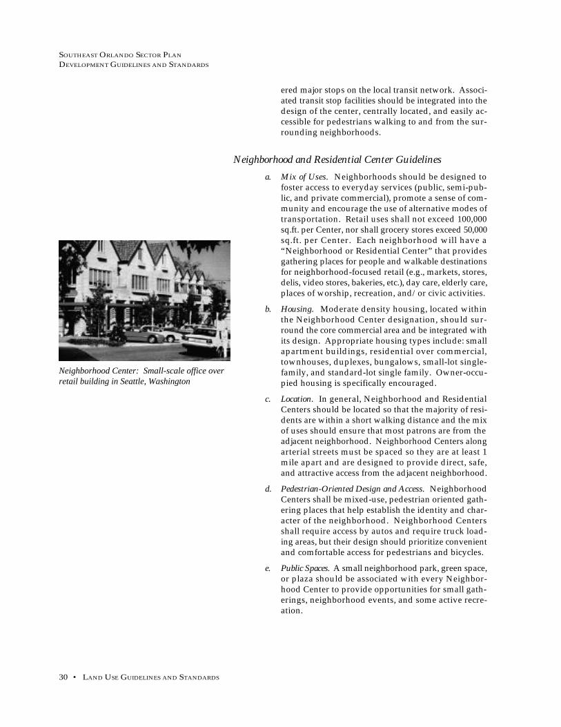
SOUTHEAST ORLANDO SECTOR PLAN
DEVELOPMENT GUIDELINES AND STANDARDS
30 • LAND USE GUIDELINES AND STANDARDS
ered major stops on the local transit network. Associ-ated transit stop facilities should be integrated into thedesign of the center, centrally located, and easily ac-cessible for pedestrians walking to and from the sur-rounding neighborhoods.
Neighborhood and Residential Center Guidelines
a. Mix of Uses. Neighborhoods should be designed tofoster access to everyday services (public, semi-pub-lic, and private commercial), promote a sense of com-munity and encourage the use of alternative modes oftransportation. Retail uses shall not exceed 100,000sq.ft. per Center, nor shall grocery stores exceed 50,000sq.ft. per Center. Each neighborhood will have a“Neighborhood or Residential Center” that providesgathering places for people and walkable destinationsfor neighborhood-focused retail (e.g., markets, stores,delis, video stores, bakeries, etc.), day care, elderly care,places of worship, recreation, and/or civic activities.
b. Housing. Moderate density housing, located withinthe Neighborhood Center designation, should sur-round the core commercial area and be integrated withits design. Appropriate housing types include: smallapartment buildings, residential over commercial,townhouses, duplexes, bungalows, small-lot single-family, and standard-lot single family. Owner-occu-pied housing is specifically encouraged.
c. Location. In general, Neighborhood and ResidentialCenters should be located so that the majority of resi-dents are within a short walking distance and the mixof uses should ensure that most patrons are from theadjacent neighborhood. Neighborhood Centers alongarterial streets must be spaced so they are at least 1mile apart and are designed to provide direct, safe,and attractive access from the adjacent neighborhood.
d. Pedestrian-Oriented Design and Access. NeighborhoodCenters shall be mixed-use, pedestrian oriented gath-ering places that help establish the identity and char-acter of the neighborhood. Neighborhood Centersshall require access by autos and require truck load-ing areas, but their design should prioritize convenientand comfortable access for pedestrians and bicycles.
e. Public Spaces. A small neighborhood park, green space,or plaza should be associated with every Neighbor-hood Center to provide opportunities for small gath-erings, neighborhood events, and some active recre-ation.
Neighborhood Center: Small-scale office overretail building in Seattle, Washington

SOUTHEAST ORLANDO SECTOR PLAN
DEVELOPMENT GUIDELINES AND STANDARDS
MAY 10, 1999 • 31
Residential Neighborhood Guidelines and Standardsa. Residential Neighborhood Structure. All neighborhoods
shall be mixed-use, that is, neighborhoods shall con-tain both residential and non-residential uses. Resi-dential uses will include both single-family and multi-family housing types. The majority of non-residentialuses shall clustered in the Neighborhood andResidentail Centers, including: retail and non-retailcommercial and business uses as well as public andsemi-public uses such as day care, churches, and civiccenters. Schools and major parks should be locatedoutside of the Neighborhood and Residential Centers,because of their larger land area requirements. Retail,commercial, and business uses shall not be located out-side of the Neighborhood or Residential Centers.Neighborhood will be pedestrian and bicycle friendly.
1. Neighborhoods shall be scaled to the pedes-trian, with Neighborhood and ResidentialCenters within a comfortable 1/4 to 1/3 milewalking distance of most homes.
2. Land use boundaries and density changes inneighborhoods should occur at mid-block lo-cations whenever possible, rather than alongstreets so that buildings facing each other arecompatible and transitions between uses aregradual.
b. Location and Density. Residential Neighborhoods shall:
1. Be located in the areas depicted on the MasterPlan Map.
2. Have a maximum density of 12 dwelling unitsper gross acre.
3. Contain the following residential housingtypes: large-lot, standard-lot, and small-lotsingle-family homes; townhomes and othertypes of attached single-family houses; du-plexes and multi-family units up to four-plexes; and ancillary dwelling units. Owner-occupied housing is specifically encouraged.
4. Focus on a centrally-located Residential Cen-ter, Neighborhood Center or Village Centerwhich will include public, semi-public, andprivate services and uses.
c. Housing Diversity. Each neighborhood shall include avariety of housing types and styles to allow peoplewith a range of different ages and incomes to live inthe neighborhood of their choice as an integrated anddiverse community. In order to maintain the desireddensity of residential neighborhoods, a variety of hous-ing types, lot sizes, and patterns shall be required. Each
Small-lot Single-Family homes at Harbortown,Tennessee
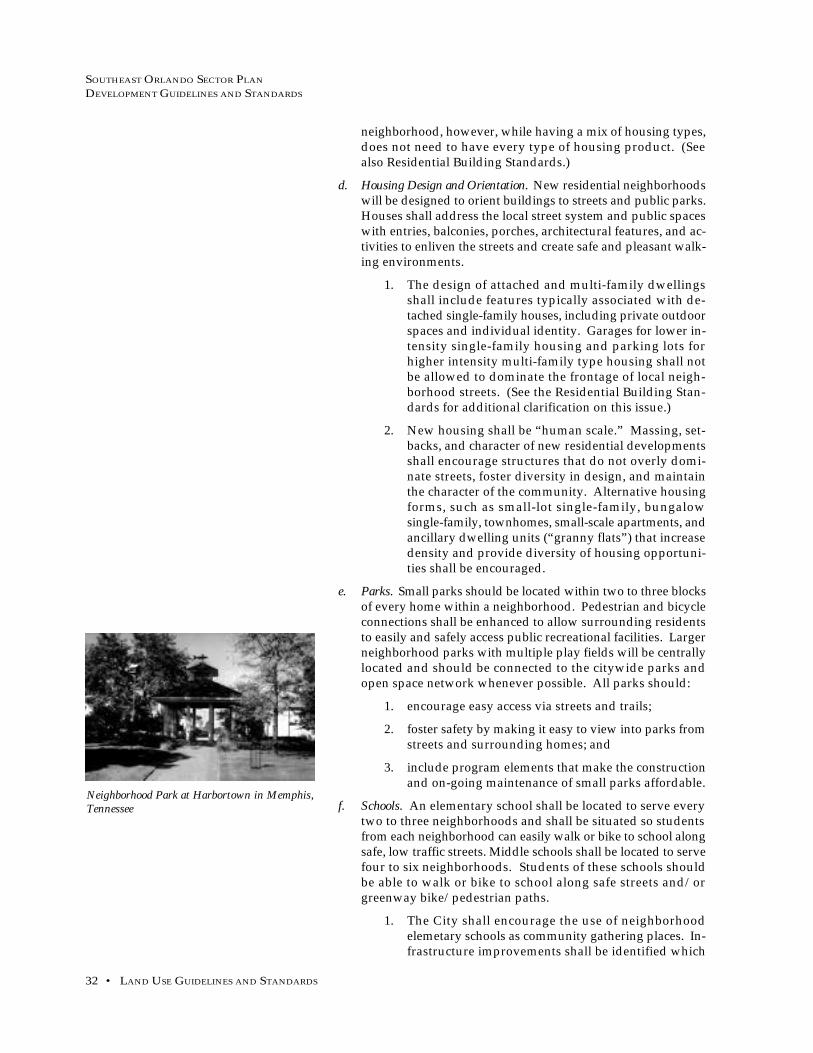
SOUTHEAST ORLANDO SECTOR PLAN
DEVELOPMENT GUIDELINES AND STANDARDS
32 • LAND USE GUIDELINES AND STANDARDS
neighborhood, however, while having a mix of housing types,does not need to have every type of housing product. (Seealso Residential Building Standards.)
d. Housing Design and Orientation. New residential neighborhoodswill be designed to orient buildings to streets and public parks.Houses shall address the local street system and public spaceswith entries, balconies, porches, architectural features, and ac-tivities to enliven the streets and create safe and pleasant walk-ing environments.
1. The design of attached and multi-family dwellingsshall include features typically associated with de-tached single-family houses, including private outdoorspaces and individual identity. Garages for lower in-tensity single-family housing and parking lots forhigher intensity multi-family type housing shall notbe allowed to dominate the frontage of local neigh-borhood streets. (See the Residential Building Stan-dards for additional clarification on this issue.)
2. New housing shall be “human scale.” Massing, set-backs, and character of new residential developmentsshall encourage structures that do not overly domi-nate streets, foster diversity in design, and maintainthe character of the community. Alternative housingforms, such as small-lot single-family, bungalowsingle-family, townhomes, small-scale apartments, andancillary dwelling units (“granny flats”) that increasedensity and provide diversity of housing opportuni-ties shall be encouraged.
e. Parks. Small parks should be located within two to three blocksof every home within a neighborhood. Pedestrian and bicycleconnections shall be enhanced to allow surrounding residentsto easily and safely access public recreational facilities. Largerneighborhood parks with multiple play fields will be centrallylocated and should be connected to the citywide parks andopen space network whenever possible. All parks should:
1. encourage easy access via streets and trails;
2. foster safety by making it easy to view into parks fromstreets and surrounding homes; and
3. include program elements that make the constructionand on-going maintenance of small parks affordable.
f. Schools. An elementary school shall be located to serve everytwo to three neighborhoods and shall be situated so studentsfrom each neighborhood can easily walk or bike to school alongsafe, low traffic streets. Middle schools shall be located to servefour to six neighborhoods. Students of these schools shouldbe able to walk or bike to school along safe streets and/orgreenway bike/pedestrian paths.
1. The City shall encourage the use of neighborhoodelemetary schools as community gathering places. In-frastructure improvements shall be identified which
Neighborhood Park at Harbortown in Memphis,Tennessee

SOUTHEAST ORLANDO SECTOR PLAN
DEVELOPMENT GUIDELINES AND STANDARDS
MAY 10, 1999 • 33
are needed to make school sites available for eveningand weekend use (e.g., better lighting and improvedsecurity).
2. Where appropriate, elementary schools should be lo-cated adjacent to Neighborhood Centers and Residen-tial Centers and explore opportunities for incorporat-ing civic programs, such as places for cultural events,adult education, recreation facilities, branch libraries,and child care.
g. Street Configuration. Local streets shall form an interconnectednetwork, including automobile, bicycle, and pedestrian routes,that provide direct connections to local destinations. Localstreets shall provide for both intra- and inter-neighborhoodconnections and thus knit neighborhoods together, not formbarriers between them. Proposals for gated entryways intonew developments or neighborhoods shall be reviewed forconformance with the City’s Land Development Code. In gen-eral, gated communities shall not be permitted unless the siteis either surrounded by wetlands on three sides or is a pocketof land within a street system that does not connect throughsome type of Mixed Use Center.
h. Street Design. Local streets shall be considered to be both pub-lic ways and neighborhood amenities. They will have con-tinuous detached sidewalks, bikeways, street trees, and otheramenities, such as benches, that favor the pedestrian. Indi-vidual residential homes should provide entries, gates,porches, and other inviting features that face local streets tohelp create a sense of community and improve safety.
i. Edges. Arterial streets, changes in street fabric, greenways, andnatural features (such as wetlands, lakes, and major creeks)should define the edge of a neighborhood. Landscaped set-backs and trails should be used to create an attractive envi-ronment at a neighborhood’s edge.
j. Natural Features. Valuable natural features including creeks,significant trees, and wetlands shall be protected and accen-tuated through sensitive site planning, building placement,and other measures.
k. Phasing. Neighborhoods should be livable at all stages of theirdevelopment. The City shall require the provision of impor-tant public facilities concurrently with new development, in-cluding streets, utilities, local neighborhood parks, schools,and civic buildings.
Local Street
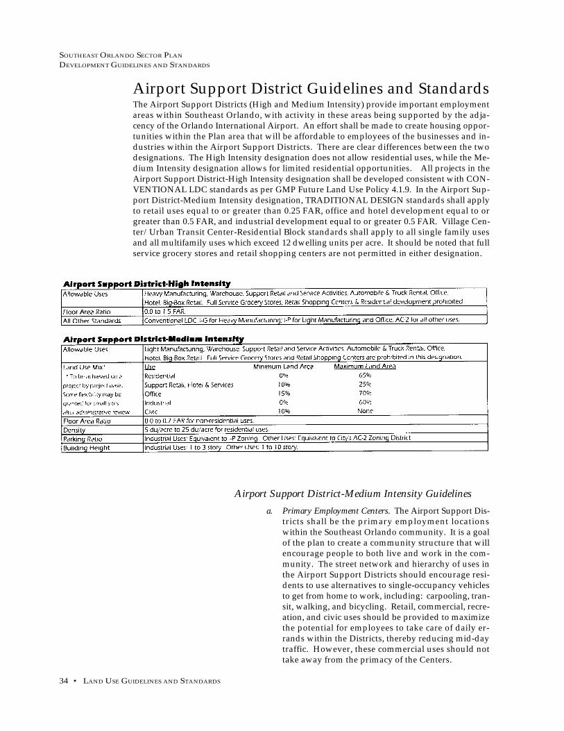
SOUTHEAST ORLANDO SECTOR PLAN
DEVELOPMENT GUIDELINES AND STANDARDS
34 • LAND USE GUIDELINES AND STANDARDS
Airport Support District Guidelines and Standards
Airport Support District-Medium Intensity Guidelines
a. Primary Employment Centers. The Airport Support Dis-tricts shall be the primary employment locationswithin the Southeast Orlando community. It is a goalof the plan to create a community structure that willencourage people to both live and work in the com-munity. The street network and hierarchy of uses inthe Airport Support Districts should encourage resi-dents to use alternatives to single-occupancy vehiclesto get from home to work, including: carpooling, tran-sit, walking, and bicycling. Retail, commercial, recre-ation, and civic uses should be provided to maximizethe potential for employees to take care of daily er-rands within the Districts, thereby reducing mid-daytraffic. However, these commercial uses should nottake away from the primacy of the Centers.
The Airport Support Districts (High and Medium Intensity) provide important employmentareas within Southeast Orlando, with activity in these areas being supported by the adja-cency of the Orlando International Airport. An effort shall be made to create housing oppor-tunities within the Plan area that will be affordable to employees of the businesses and in-dustries within the Airport Support Districts. There are clear differences between the twodesignations. The High Intensity designation does not allow residential uses, while the Me-dium Intensity designation allows for limited residential opportunities. All projects in theAirport Support District-High Intensity designation shall be developed consistent with CON-VENTIONAL LDC standards as per GMP Future Land Use Policy 4.1.9. In the Airport Sup-port District-Medium Intensity designation, TRADITIONAL DESIGN standards shall applyto retail uses equal to or greater than 0.25 FAR, office and hotel development equal to orgreater than 0.5 FAR, and industrial development equal to or greater 0.5 FAR. Village Cen-ter/Urban Transit Center-Residential Block standards shall apply to all single family usesand all multifamily uses which exceed 12 dwelling units per acre. It should be noted that fullservice grocery stores and retail shopping centers are not permitted in either designation.

SOUTHEAST ORLANDO SECTOR PLAN
DEVELOPMENT GUIDELINES AND STANDARDS
MAY 10, 1999 • 35
b. Pattern of Streets and Buildings. It is a goal of the plan to createan environment that is scaled to the needs of pedestrians andbicyclists. Blocks greater than 600 ft. in length, dead end streetsand cul-de-sacs should be avoided. Within larger blocks ofemployment use, pedestrian/bicycle pathways shall be pro-vided to increase accessibility within the block and to adjacentareas within the district. All buildings should contribute to acohesive city “fabric” and reinforce the overall goal of creat-ing a walkable district. Buildings should offer attractive pe-destrian scale features and spaces. Building placement andmassing should relate to nearby buildings within the Districtand to the urban context.
c. Mixed-Use Precincts. Airport Support District-Medium Inten-sity areas shall be developed with a hierarchy of uses that cre-ates nodes of activity (Mixed-Use Precincts). More intensiveuses — offices, hotel, restaurant and retail, and civic uses (i.e. -day care) — shall be clustered around public spaces in theMixed-Use Precincts. Street networks shall provide pedestrian,transit and bicycle access from surrounding areas of lower in-tensity office and industrial development.
d. Local Connections. Direct local street access within the districtsand from surrounding areas of development shall be providedso that workers and visitors do not need to use only arterialstreets for access.
e. Public Spaces. Similar to mixed-use centers and residential neigh-borhoods, parks and plazas shall be used to create an identityfor the activity centers within the districts and to provide reliefin the urban fabric.
f. Relationship of Building to Public Spaces. Buildings should rein-force and provide vitality to streets and public spaces, by pro-viding an ordered variety of entries, windows, bays, and bal-conies along public ways. Where buildings are not used toform street edges, landscape treatments shall create a human-scaled pedestrian environment and a buffer to adjacent park-ing lots and work areas. Buildings should have human scalein details and massing. Free-standing or “monument” build-ing should be reserved for civic uses.
g. Arterial Streets as Edges. Arterial streets should be consideredas edges to subareas within the Airport Support District, un-less substantial pedestrian improvements are made and trafficis slowed along the arterial street.
h. Integration of Transit Stops. Mixed-Use Precincts within theAirport Support District should be considered major stops onthe local transit network. Associated transit stop facilitiesshould be integrated into the design of the node, centrally lo-cated, and easily accessible for pedestrians walking to and fromthe surrounding employment areas.
i. Truck Access. Truck traffic generated by uses within the Air-port Support Districts shall be directed to the arterial streetsystem and shall not be allowed to travel through adjacent resi-dential neighborhoods.

SOUTHEAST ORLANDO SECTOR PLAN
DEVELOPMENT GUIDELINES AND STANDARDS
36 • LAND USE GUIDELINES AND STANDARDS
Other Land Use Guidelines and StandardsEstate Residential (Within Residential Neighborhoods)
In certain Residential Neighborhood areas within Southeast Or-lando, a more rural development pattern which recognizes uniqueenvironmental conditions may be appropriate. Designation of suchareas shall be determined through master plan review of individualprojects. General guidelines for estate residential (or estate pre-serve) areas are discussed below, while more specific buildingguidelines and standards are provided in the Residential BuildingStandards. Allowable uses include:
• clustered residential development with a gross density of
1 dwelling unit per acre;
• parks, recreation, and open space; and
• public or private golf courses.
The most environmentally sensitive areas (i.e. - wetlands, treestands, clusters of high quality shrubs and undergrowth) shouldbe preserved with residential clusters, roadways, trails, and devel-oped open space elements knitted around these areas.
a. Residential Clusters. The pattern of residential clustersshall allow for sensitive development of some naturalareas within Southeast Orlando. The maximum num-ber of units that can be developed within estate resi-dential areas is 1 unit per gross acre. Buildings shallbe sited within a 1/4 acre “buildable envelope.” Ar-
Clustered Option Dispersed Option

SOUTHEAST ORLANDO SECTOR PLAN
DEVELOPMENT GUIDELINES AND STANDARDS
MAY 10, 1999 • 37
eas outside of the buildable envelope shall be kept ina more natural state, but can include roads and trails.Only areas within the buildable envelope may befenced, irrigated, landscaped, or built upon. Severalmethods of ownership and protection of the areas out-side of the buildable envelope are possible, including:
• Private ownership with protective cov-enants and public trail easements;
• Joint ownership with protective covenantsand public trail easements;
• Ownership by a private conservationtrust; or
• Public ownership.
Buildings and structures in the estate residentialshould use materials and colors that provide a moreneutral character to the architecture, allowing thebuildings to integrate with the landscape.
b. Street Design. Streets within the estate residential ar-eas should be more rural in character. Only moreheavily traveled streets should have sidewalks andplanter strips. Landscaping should have a less formalstructure and native plantings should be used for streettrees and ground cover. Swales may be used withinEstate Residential areas only after approval by the CityPlanning Official and the City Engineer.
c. Wildlife Corridors. Site planning of the estate residen-tial areas shall take into consideration the provision ofwildlife corridor connections between adjacent areaswithin the Primary Conservation Network. To thegreatest extent possible, street crossings of the corri-dors should be minimized. The corridors should alsolink the highest quality habitats within the estate pre-serve area.
d. Trails. Site planning shall also provide public trail con-nection links from trails within the Primary Conser-vation Network.

SOUTHEAST ORLANDO SECTOR PLAN
DEVELOPMENT GUIDELINES AND STANDARDS
38 • BUILDING GUIDELINES AND STANDARDS
BUILDING GUIDELINES AND STANDARDS
This section of the standards provides requirements and guidelines for specific
building types within the plan’s mixed-use centers and districts. Topics addressed
include:
• residential densities and commercial/employment intensities;
• building height;
• setbacks and configuration;
• facade and entry location and design;
• roof massing and design;
• crime prevention through environmental design; and
• building materials.
Residential Building StandardsResidential uses are permitted in six land use designations as iden-
tified on the Southeast Orlando Master Plan Map: Town Center,
Village Center, Neighborhood Center, Residential Center, Residen-
tial Neighborhood, and Airport Support District-Medium Inten-
sity. The following building standards apply to all land use desig-
nations that permit residential uses.
Mix of Housing Types
a. Housing Mix in All Types of Neighborhoods. Within eachresidential area, with the exception of Airport SupportDistrict residential, a mix of housing types is required.Housing types vary by lot size and form. These crite-ria are intended to insure that homes integrate wellwith each other and share designs which make neigh-borhood streets safe and enjoyable to walk along. Lotsizes and patterns within a neighborhood shall be var-ied to avoid monotonous streetscapes and provide adiverse range of housing types. Each developer ofmore than fifteen (15) acres shall provide at least three(3) housing types. For example, larger building typeson larger lots are encouraged on corners. Smaller lotsare encouraged surrounding common open spaces.
b. Lot Sizes and Densities. The following table summa-rizes lot sizes and approximate densities for a varietyof housing types. Densities apply to gross develop-able acreage.

SOUTHEAST ORLANDO SECTOR PLAN
DEVELOPMENT GUIDELINES AND STANDARDS
MAY 10, 1999 • 39
Housing Model VarietyVariation in individual housing “types” results in different “mod-
els”. Each model may have the same lot size and basic floor plan
but is differentiated by varied exterior treatments and materials.
Variations in building mass, entry and porch design, window pat-
tern, roof form, and/or other architectural features are strongly
encouraged.
studio or 1-bedroom unit over
garage; 600 sq.ft. maximum
7,000-43,560 sq.ft.

SOUTHEAST ORLANDO SECTOR PLAN
DEVELOPMENT GUIDELINES AND STANDARDS
40 • BUILDING GUIDELINES AND STANDARDS
a. Model Variety. Each development of 100 or more homesshall have at least four models with three elevationsand material treatments each. For developments ofless than 100 units, at least three models with threevariations each are required. No street block shouldhave more than two consecutive single-family homeswith the same house model.
Relation of Buildings to Streets and Parking
a. Orientation. Primary facades shall contain the primaryentry and shall be street-facing. The principal orien-tation of the front facade of all buildings shall be par-allel or nearly parallel to the streets they face. Wherepublic parks are located across a street, the front fa-cade should face the public park. Rear yards shall notoccur along local or connector streets.
b. Homes Adjacent to Parkways and Arterial Streets. Whereresidential areas abut parkways and arterial streets,lotting and home placement should address thesemajor streets in one of three ways:
1. Homes front onto these streets with largerfront setbacks and alley-accessed garages;
2. a frontage road is built adjacent to the majorstreet right-of-way that provides a landscaped,“slow-traffic” local street for homes to frontonto; or
3. cul-de-sac streets intersect with the majorstreet with an opening or gated entry for pe-destrians; homes may have side yards facingonto the major street.
c. Primary Entry and Porches. With the exception of four-plexes, apartments, and ancillary dwelling units, ev-ery home shall have its primary entry (front door) fac-ing a public street and not more than 6 feet recessedback from the face of the primary facade. Four-plexesand apartments may have their primary entry facinga central, landscaped courtyard. Ancillary dwellingunits may face an internal walkway, driveway, or al-ley. Porches for all residential types shall be accesseddirectly from a public street or pedestrian easementand must be visible from the street. Porches may ex-tend 6 feet into the setback. Front porches must havea minimum depth of six feet clear and comprise a mini-mum of 30% of the width of a building’s primary frontfacade (not including the garage) or 10 feet clear which-ever is larger. Porches for duplexes, condos, and apart-ments may be shared. Tunnel-like entrances are spe-cifically discouraged.
Open Ended Cul-de-Sac
Entry elements shall cover at least 30% of primaryfacade or 10 feet whichever is greater.

SOUTHEAST ORLANDO SECTOR PLAN
DEVELOPMENT GUIDELINES AND STANDARDS
MAY 10, 1999 • 41
d. Garages. Residential streetscapes shall not be domi-nated by garages. Garage frontage shall also be lim-ited for single-family houses, duplexes andtownhomes; garages shall not comprise more than 50%of a building’s street-facing frontage.
Garages for estate preserve, large-lot single-family,standard-lot single-family, small-lot single-family, bun-galow single-family, and duplex type shall be providedin two ways:
1. attached and recessed from the primary frontfacade (not including porches, bay windows,or other minor projections) by a minimum of8 feet and at least 24 feet from the street right-of-way; OR
2. attached or detached, placed at the rear prop-erty line, and accessed by either an alley or aside yard driveway. In each development ofsingle-family houses and/or duplexes, nomore than 50% of the units may have a re-cessed, front-loaded garage.
Garages for townhouse and apartment types may beeither:
1. attached or detached, placed at the rear prop-erty line, and accessed by an alley; OR
2. for apartments, carports or garages may begrouped together and placed behind the resi-dential buildings.
Front Setbacks
Front setbacks are measured from the right-of-way line of the ad-jacent street or park. The following table summarizes minimumand maximum setbacks by location of the residential building.
Attached recessed garage
Sidedrive attached garage
Sidedrive detached garage

SOUTHEAST ORLANDO SECTOR PLAN
DEVELOPMENT GUIDELINES AND STANDARDS
42 • BUILDING GUIDELINES AND STANDARDS
Other Setbacks
a. Side yard setbacks in residential areas shall be a mini-mum of 5 feet from the property line, unless a zero-lotline is proposed. If a zero-lot line unit is proposed, asingle 5 foot side yard is required.
b. Side driveways extending along the property line to arecessed garage are permitted and encouraged withinthe side yard setback.
c. Rear yard setbacks in residential areas shall be a mini-mum of 15 feet from the rear property line, except togarages, where the minimum setback shall be 0 feetand for alley-accessed garages and ancillary unitswhere the minimum setback shall be 6 feet.
Building HeightsThe following table summarizes minimum and maximum residen-
tial building heights by location of the residential building.
Facades and Roof Form
a. Facade Articulation. The facades of all residential build-ings that face adjacent structure, park or open spaceshall be articulated. Articulation may include porches,bay windows and/or balconies.
b. Windows. All street-facing facades shall have windowscovering at least 15% of the facade’s area. The largestwindow or group of windows of the living room, din-ing room, or family room should be fully visible fromthe street.
c. Garage Door Treatments. All residential garage doorsvisible from a street or park shall consist of articulatedpanels and incorporate at least two of the followingfeatures:
1. indoor living space or balcony space built overthe garage with clear sight lines between thestreet and these spaces;
2. strong shadow lines around the garage face
Porches and balconies at Harbortown in Memphis,Tennessee
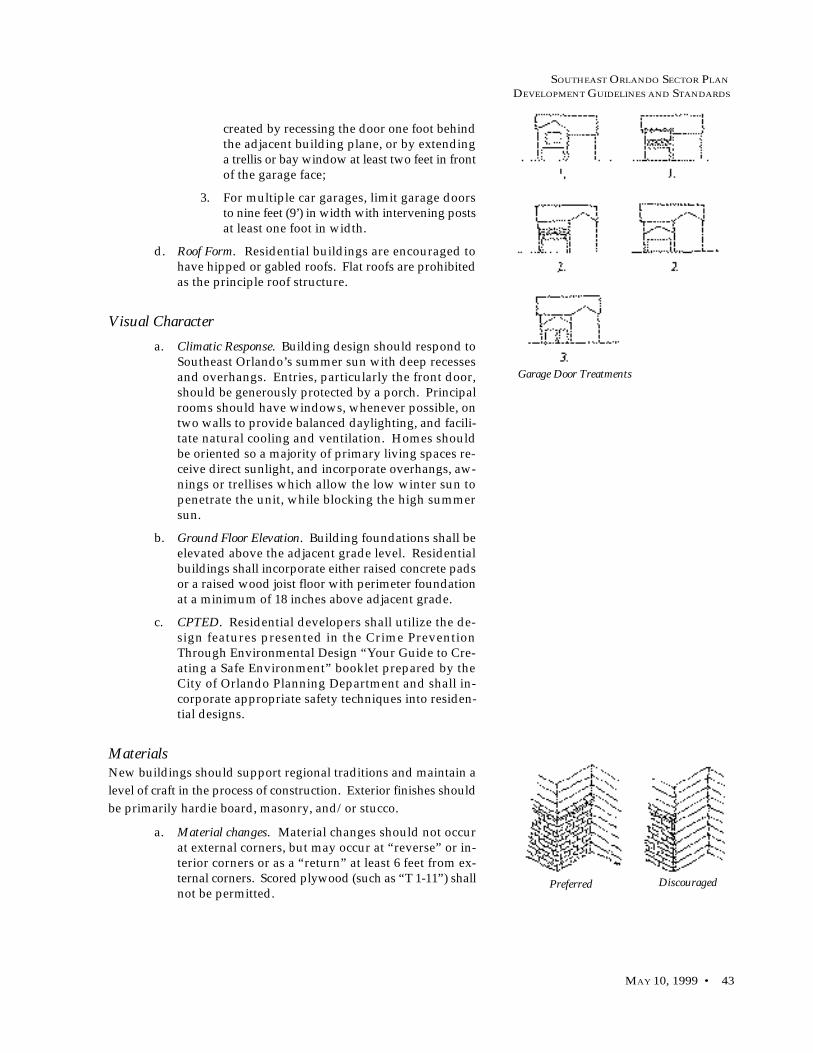
SOUTHEAST ORLANDO SECTOR PLAN
DEVELOPMENT GUIDELINES AND STANDARDS
MAY 10, 1999 • 43
created by recessing the door one foot behindthe adjacent building plane, or by extendinga trellis or bay window at least two feet in frontof the garage face;
3. For multiple car garages, limit garage doorsto nine feet (9’) in width with intervening postsat least one foot in width.
d. Roof Form. Residential buildings are encouraged tohave hipped or gabled roofs. Flat roofs are prohibitedas the principle roof structure.
Visual Character
a. Climatic Response. Building design should respond toSoutheast Orlando’s summer sun with deep recessesand overhangs. Entries, particularly the front door,should be generously protected by a porch. Principalrooms should have windows, whenever possible, ontwo walls to provide balanced daylighting, and facili-tate natural cooling and ventilation. Homes shouldbe oriented so a majority of primary living spaces re-ceive direct sunlight, and incorporate overhangs, aw-nings or trellises which allow the low winter sun topenetrate the unit, while blocking the high summersun.
b. Ground Floor Elevation. Building foundations shall beelevated above the adjacent grade level. Residentialbuildings shall incorporate either raised concrete padsor a raised wood joist floor with perimeter foundationat a minimum of 18 inches above adjacent grade.
c. CPTED. Residential developers shall utilize the de-sign features presented in the Crime PreventionThrough Environmental Design “Your Guide to Cre-ating a Safe Environment” booklet prepared by theCity of Orlando Planning Department and shall in-corporate appropriate safety techniques into residen-tial designs.
MaterialsNew buildings should support regional traditions and maintain a
level of craft in the process of construction. Exterior finishes should
be primarily hardie board, masonry, and/or stucco.
a. Material changes. Material changes should not occurat external corners, but may occur at “reverse” or in-terior corners or as a “return” at least 6 feet from ex-ternal corners. Scored plywood (such as “T 1-11”) shallnot be permitted.
Preferred Discouraged
Garage Door Treatments

SOUTHEAST ORLANDO SECTOR PLAN
DEVELOPMENT GUIDELINES AND STANDARDS
44 • BUILDING GUIDELINES AND STANDARDS
Housing Type IllustrativesThe following plans and axonometric drawings illustrate the vari-
ous housing types and clarify some design guidelines and stan-
dards that are specific to certain types. All house designs for the
Southeast Orlando Sector Plan must comply with the complete
guidelines and standards as illustrated in this document and speci-
fied in Chapter 68 of the Land Development Code.
Pedestrian Access Ways and Bicycle CirculationAll residential developments shall be designed so as to promote
pedestrian and bicycle circulation within the development and to
promote access to surrounding areas, including schools, parks,
mixed use centers, and other designations, consistent with Chap-
ter 60 of the Land Development Code. Entry posts, columns, and/
or landscaping should be installed where an internal sidewalk in-
tersects with a public sidewalk.

SOUTHEAST ORLANDO SECTOR PLAN
DEVELOPMENT GUIDELINES AND STANDARDS
MAY 10, 1999 • 45
Estate Residential
Axonometric
Plan
• Minimum 8-foot setback fromprimary facade to front-loadedgarage
• Side drives should be “Rib-bon-Strip” drives, consistingof a side driveway with amedian planting strip
• 12-foot maximum drivewaywidth at street right-of-way
• Parking court can be usedas a paved play area
• Entry porches are required along30% of primary facade of eachunit
• Ancillary units are encouraged• Ancillary unit stair location pre-
ferred on side of garage
PrimaryConservation Network
Buffer
PrivateOpen Space
Detachedgarage
Street trees
1/4 acre “buildable” envelope
Mainhouse
Swales may only be used with approval ofthe City Planning Official and Transporta-tion Engineer.

SOUTHEAST ORLANDO SECTOR PLAN
DEVELOPMENT GUIDELINES AND STANDARDS
46 • BUILDING GUIDELINES AND STANDARDS
Single-Family Large-Lot
Axonometric
Plan
• Minimum 8-foot setback fromprimary facade to front-loadedgarage
• Side drives should be “Rib-bon-Strip” drives, consistingof a side driveway with amedian planting strip
• 12-foot maximum drivewaywidth at street right-of-way
• Parking court can be usedas a paved play area
• Entry porches are requiredalong 30% of primary fa-cade of each unit
• Ancillary units are encour-aged
• Ancillary unit stair locationpreferred on side of garage
Parkingcourt
Porch
Street trees
“Hollywood”drive
Main house
Public Street
Main house
Attachedgarage
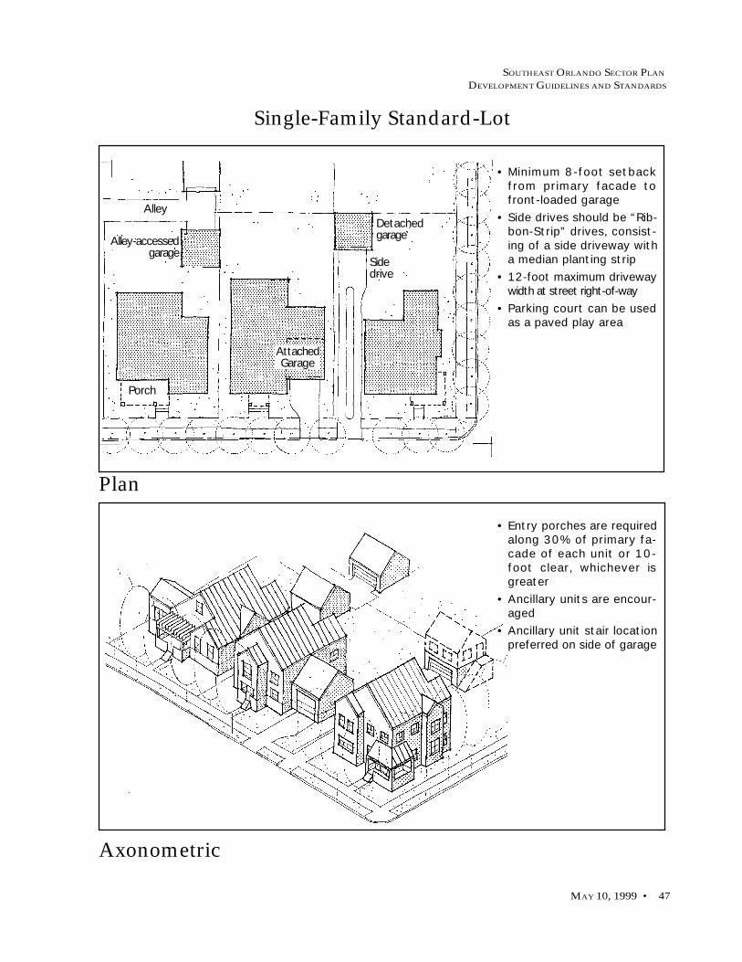
SOUTHEAST ORLANDO SECTOR PLAN
DEVELOPMENT GUIDELINES AND STANDARDS
MAY 10, 1999 • 47
Single-Family Standard-Lot
Axonometric
Plan
• Minimum 8-foot setbackfrom primary facade tofront-loaded garage
• Side drives should be “Rib-bon-Strip” drives, consist-ing of a side driveway witha median planting strip
• 12-foot maximum drivewaywidth at street right-of-way
• Parking court can be usedas a paved play area
• Entry porches are requiredalong 30% of primary fa-cade of each unit or 10-foot clear, whichever isgreater
• Ancillary units are encour-aged
• Ancillary unit stair locationpreferred on side of garage
DetachedgarageAlley-accessed
garage
Alley
Porch
Sidedrive
AttachedGarage

SOUTHEAST ORLANDO SECTOR PLAN
DEVELOPMENT GUIDELINES AND STANDARDS
48 • BUILDING GUIDELINES AND STANDARDS
Single-Family Small-Lot
Axonometric
Plan
• Encourage rear garagesserved by a mid-block alley
• Minimum 8-foot setbackfrom primary facade tofront-loaded garage
• Side drives to be “Ribbon-Strip” drives, consisting ofa side driveway with a me-dian planting strip
• 9-foot maximum drivewaywidth at street right-of-way
• Parking court can be usedas a paved play area
• Entry porches are requiredalong 30% of primary fa-cade of each unit or 10-foot clear, whichever isgreater
• Ancillary units are encour-aged
• Ancillary unit stair locationpreferred on side of garage
Alley
Detached garages
Sidedrive
Attachedgarage
Porch
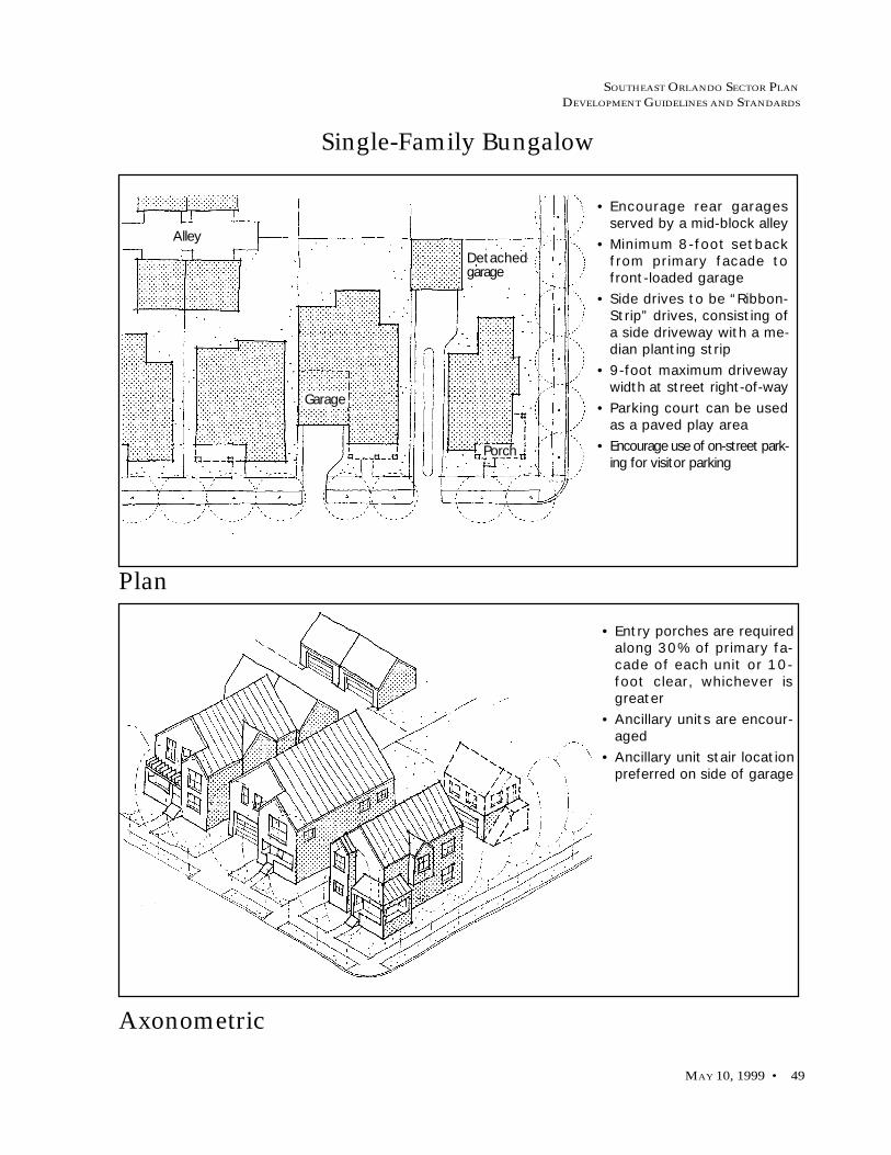
SOUTHEAST ORLANDO SECTOR PLAN
DEVELOPMENT GUIDELINES AND STANDARDS
MAY 10, 1999 • 49
Single-Family Bungalow
Axonometric
Plan
• Encourage rear garagesserved by a mid-block alley
• Minimum 8-foot setbackfrom primary facade tofront-loaded garage
• Side drives to be “Ribbon-Strip” drives, consisting ofa side driveway with a me-dian planting strip
• 9-foot maximum drivewaywidth at street right-of-way
• Parking court can be usedas a paved play area
• Encourage use of on-street park-ing for visitor parking
• Entry porches are requiredalong 30% of primary fa-cade of each unit or 10-foot clear, whichever isgreater
• Ancillary units are encour-aged
• Ancillary unit stair locationpreferred on side of garage
Detachedgarage
Alley
Porch
Garage
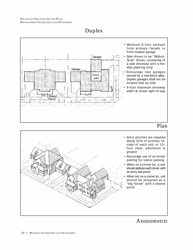
SOUTHEAST ORLANDO SECTOR PLAN
DEVELOPMENT GUIDELINES AND STANDARDS
50 • BUILDING GUIDELINES AND STANDARDS
Duplex
Axonometric
Plan
• Minimum 8-foot setbackfrom primary facade tofront-loaded garage
• Side drives to be “Ribbon-Strip” drives, consisting ofa side driveway with a me-dian planting strip
• Encourage rear garagesserved by a mid-block alley.Duplex garages shall not belocated side by side.
• 9-foot maximum drivewaywidth at street right-of-way
• Entry porches are requiredalong 30% of primary fa-cade of each unit or 10-foot clear, whichever isgreater
• Encourage use of on-streetparking for visitor parking
• When on a corner lot, a unitshould address each street withan entry and porch
• When not on a corner lot, unitshould be designed as a“big house” with a sharedporch
Garage
Garage
SharedPorch
Court-yard

SOUTHEAST ORLANDO SECTOR PLAN
DEVELOPMENT GUIDELINES AND STANDARDS
MAY 10, 1999 • 51
Townhouse/Rowhouse
Axonometric
Plan
• Garages accessible frompublic streets are prohib-ited
• Garage access from alleyslocated at rear of lots isrequired
• Tandem parking is permit-ted in garages
• Entry porches are requiredalong 30% of primary fa-cade of each unit or 10-foot clear, whichever isgreater
• Encourage use of on-streetparking for visitor parking
On-street parking
Alley
Public street
Street trees
Back yards

SOUTHEAST ORLANDO SECTOR PLAN
DEVELOPMENT GUIDELINES AND STANDARDS
52 • BUILDING GUIDELINES AND STANDARDS
Four-Plex
Axonometric
Plan
• Garage access from alley ordriveway located at rear oflots is required
• Encourage pedestrian con-nections from parking areasto building entries at pub-lic streets.
• Encourage use of on-streetparking for visitor parking
• Entry porches for groundfloor units which have di-rect access to publicstreets shall have a 10-footminimum width
• Provide balconies for abovegrade units facing the street
• Minimum 2-story buildingwall required along publicstreets
Pedestrianwalkways
Alley or driveway
Garageentry

SOUTHEAST ORLANDO SECTOR PLAN
DEVELOPMENT GUIDELINES AND STANDARDS
MAY 10, 1999 • 53
Garden Apartments
Axonometric
Plan
• Minimum 30-foot separationbetween neighboring buildings
• Locate parking to the rear ofbuildings away from publicview.
• Provide pedestrian connec-tions from parking areas tobuilding entries at publicstreets.
• Minimize the number of accessdrives and curb cuts to park-ing.
• Provide a minimum 15-footlandscape separation betweenparking and residential units.
• Encourage use of on-streetparking for visitor parking
• Screen trash enclosures frompublic view with a fence andlandscaping.
• Entry porches for ground floorunits which have direct accessto public streets shall have a10-foot minimum width
• Provide balconies for abovegrade units facing the street
• Minimum 2-story building wallalong public streets is required
Parking lot
Entry Entry
Entry
On-street parking

SOUTHEAST ORLANDO SECTOR PLAN
DEVELOPMENT GUIDELINES AND STANDARDS
54 • BUILDING GUIDELINES AND STANDARDS
Tuck-Under Apartments
Axonometric
Plan
• Minimum 20-foot separationbetween neighboring buildings
• Garages facing and accessibleto public streets are prohib-ited
• Garage access from alleys ordriveways located to the rearof lot is required
• Require pedestrian connec-tions from parking areas tobuilding entries at publicstreets
• Use on-street parking for visi-tor parking
• Entry porches for ground floorunits with direct access topublic streets shall have a 10-foot minimum width
• Provide balconies for abovegrade units facing the street
• Screen trash enclosures frompublic view with a fence andlandscaping.
• Minimum 2-story building wallalong public streets is required
Parking Drive
On-street parking
Entrywalks
Tuck-underparking

SOUTHEAST ORLANDO SECTOR PLAN
DEVELOPMENT GUIDELINES AND STANDARDS
MAY 10, 1999 • 55
Podium Apartments/Elderly Housing
Axonometric
Section
• Minimum 40-foot separationbetween neighboring buildings
• Provide parking below-gradeor 1/2 level below-grade,away from public view.
• Discourage above grade park-ing. Limit parking podium to5-foot maximum above side-walk elevation.
• Encourage use of on-streetparking for visitor parking
• Entry porches for ground floorunits which have direct accessto public streets shall have a10-foot minimum width
• Provide balconies for abovegrade units facing the street.
• Screen trash enclosures frompublic view with a fence andlandscaping
• Minimum 2-story building wallalong public streets is required
Parking
Apartment
Publicright-of-way
Entryporch
Bay windows
Apartment
Apartment

SOUTHEAST ORLANDO SECTOR PLAN
DEVELOPMENT GUIDELINES AND STANDARDS
56 • BUILDING GUIDELINES AND STANDARDS
Residential Over Commercial
Axonometric
Plan
• Orient retail and residential en-tries to face public streets andsidewalks
• Encourage pedestrian connec-tions from parking areas tobuilding entries at publicstreets
• Provide visitor drop-off areasand on-street parking at pub-lic building entries
• Locate parking to the rear ofthe building away from publicview
• Provide street trees alongdriveways, drive aisles andpedestrian connections
• Screen trash enclosures frompublic view with a fence andlandscaping
• Provide outdoor dining ter-races with tables, chairs, andother furniture to bring activ-ity to the street
• Encourage architectural ex-pression of building entry fea-tures
• Provide roof forms such aships, gables
• Screen mechanical equipmentfrom view
• Minimum 2-story building wallalong public streets is required
• Provide residential entries orlobbies with access from pub-lic street
NOTE: also see Mixed-Use andCommercial Building Sectionfor additional guidelines andstandards.
Arcade
Parking
EntryOn-street parking

SOUTHEAST ORLANDO SECTOR PLAN
DEVELOPMENT GUIDELINES AND STANDARDS
MAY 10, 1999 • 57
Ancillary Unit
Axonometric
Plan
• Ancillary units within rear 1/3of parcel allowed in rear andside yards
• Ancillary units cannot covermore than 50% of rear yard
• Care should be given in designof the ancillary unit to main-tain privacy with adjacentunits
• When located on a corner lotthe ancillary unit should havean entry porch oriented to theside street
• Entry stairs should be ac-cessed from alley and visuallyscreened from primary unit
• One on-site parking space re-quired, surface parking allowed
• Parking allowed in “Ribbon-Strip” drive off alley
• Parking allowed in parkingcourt
• Fences can screen parking
Accessfrom Alley
Alley
Mainhouse
GaragePorch

SOUTHEAST ORLANDO SECTOR PLAN
DEVELOPMENT GUIDELINES AND STANDARDS
58 • BUILDING GUIDELINES AND STANDARDS
Mixed-Use and Commercial Building Standards
Standards for mixed-use commercial and employment development encompass
five distinct land uses falling into two broad categories. Land within the Town
Center, Village Centers, Neighborhood Centers, Residential Centers, and mixed-
use precincts within the Airport Support District-Medium Intensity comprise South-
east Orlando’s pedestrian-oriented mixed-use districts and centers. These design
guidelines and standards seek to ensure that it is easy and enjoyable to walk within
these area’s shops and offices. Land designated for Airport Support District uses
are generally more automotive in scale, yet where Traditional Design standards
apply, retain provisions for internal pedestrian connections and building elements
that acknowledge the public realm; particularly within Mixed-Use Precincts.
Relation of Buildings to Streets and Parking
a. Principle Orientation. The primary facades of all build-ings in commercial, employment, and mixed-use cen-ters shall contain the primary entry and face a publicstreet, except in limited circumstances where parkinglots may be placed at the street edge. In these casesthe primary facade shall front onto a publicly acces-sible walkway that leads directly from the street to theestablishment’s front door without crossing a vehicu-lar travelway.
b. Primary Entries and Facades. The primary entry(s) ofboth business establishments and residential uses incommercial, employment, and mixed-use centers shallbe visible and accessible directly from a public street.Primary facades that front onto a street should be builtparallel or nearly parallel to the public right-of-way.
c. Street-Facing Facades. Street facing facades shall belined with windows. Blank walls and/or garage doorsshall not occupy over 50% of a principle frontage, anda section of blank wall shall not exceed 20 linear feetwithout being interrupted by a window or entry. In-dustrial/warehouse buildings shall not have a sectionof blank wall exceeding 30 linear feet without beinginterrupted by a window, entry, pilaster, lattice, changein plane, or similar element.
The street-facing portion of industrial/warehousebuildings should have administrative areas, offices,break rooms, and other uses that require windows andentries in order to maximize articulation and humanactivity at the front of these buildings.
Winter Park Street
Mizner Park Street

SOUTHEAST ORLANDO SECTOR PLAN
DEVELOPMENT GUIDELINES AND STANDARDS
MAY 10, 1999 • 59
d. Building Frontage and Parking Exposure to Streets.Building frontages should occupy no less than sixty-five percent (65%) of a block’s street-facing frontage,except for Village Center anchor stores and all Neigh-borhood Center stores and buildings. Outside of theseareas, building frontages shall occupy no less than one-third (33%) of a parcel’s street-facing frontage; streetfronting parking in these districts should be for visi-tors and short-term parking and should not be morethan one bay in depth, additional parking should belocated to the side or behind the building.
e. Walkway-Facing Facades. The main entrance of allbuildings without street edge facades shall open di-rectly onto a publicly accessible walkway. This walk-way must directly connect to an adjacent street’s side-walk without crossing a vehicular travelway. Specificconditions include:
1. Village and Neighborhood Center anchorstores (e.g. supermarkets, major drug stores),where parking may be necessary directly infront of the building. In this case, the primarypedestrian entry and windows should be vis-ible from a public street and front onto a pub-licly accessible walkway;
2. Mixed use portions of Airport Support Dis-trict-Medium Intensity designated areas,where the primary pedestrian entry and win-dows shall be visible from a public street andfront onto a publicly accessible walkway; and
3. Auto-serving uses in the Airport Support Dis-trict-Medium Intensity areas (e.g. gas stations,car washes, etc.), where the primary entryneed not face a street, however street facingwindows should occupy at least 25% of thestreet-facing facade, and the primary entryshould front onto a publicly accessible walk-way.
Anchor stores can have”departments” such as deli’s andpharmacies oriented to the street likethis Safeway in Seattle, Washington
Minimum 65% of street frontage
Minimum 65% of street frontage

SOUTHEAST ORLANDO SECTOR PLAN
DEVELOPMENT GUIDELINES AND STANDARDS
60 • BUILDING GUIDELINES AND STANDARDS
Front SetbacksStreet-facing setbacks are measured from the edge of the adjacentright-of-way.
Projections and Recesses
a. Projections. Special architectural features, such as baywindows, decorative roofs and miscellaneous entryfeatures may project up to 3 feet into front setbacksand public right-of-ways, provided that they are notless than 9 feet above the sidewalk. Trellises, canopiesand fabric awnings may project into front setbacks andpublic right-of-ways, provided they are not less than8 feet above the sidewalk. Such projections shall notobstruct the sidewalk, meaning a 5 foot wide unob-structed sidewalk maintained.
b. Recesses. A building’s first floor may be recessed fromthe front setback for the purpose of an arcade. An ar-cade should conform to the following dimensions:
1. Minimum clear height inside the arcade space:10 feet.
2. Minimum clear width inside the arcade space:8 feet.
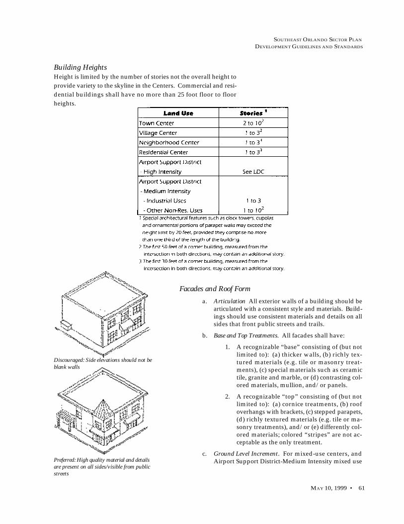
SOUTHEAST ORLANDO SECTOR PLAN
DEVELOPMENT GUIDELINES AND STANDARDS
MAY 10, 1999 • 61
Building HeightsHeight is limited by the number of stories not the overall height to
provide variety to the skyline in the Centers. Commercial and resi-
dential buildings shall have no more than 25 foot floor to floor
heights.
Facades and Roof Form
a. Articulation All exterior walls of a building should bearticulated with a consistent style and materials. Build-ings should use consistent materials and details on allsides that front public streets and trails.
b. Base and Top Treatments. All facades shall have:
1. A recognizable “base” consisting of (but notlimited to): (a) thicker walls, (b) richly tex-tured materials (e.g. tile or masonry treat-ments), (c) special materials such as ceramictile, granite and marble, or (d) contrasting col-ored materials, mullion, and/or panels.
2. A recognizable “top” consisting of (but notlimited to): (a) cornice treatments, (b) roofoverhangs with brackets, (c) stepped parapets,(d) richly textured materials (e.g. tile or ma-sonry treatments), and/or (e) differently col-ored materials; colored “stripes” are not ac-ceptable as the only treatment.
c. Ground Level Increment. For mixed-use centers, andAirport Support District-Medium Intensity mixed use
Discouraged: Side elevations should not beblank walls
Preferred: High quality material and detailsare present on all sides/visible from publicstreets

SOUTHEAST ORLANDO SECTOR PLAN
DEVELOPMENT GUIDELINES AND STANDARDS
62 • BUILDING GUIDELINES AND STANDARDS
areas, store-fronts and/or building bays should be amaximum of 30 feet in width. Bays should be definedby vertical architectural features such as columns,piers, and fenestration.
d. Storefronts . Display windows should encompass aminimum of 40% and a maximum of 80% of astorefront’s linear frontage.
e. Entries. Primary pedestrian entries should be clearlyexpressed and be recessed or framed by a shelteringelement such as an awning, arcade, porch, or portico.
f. Awnings. Awnings should be no wider than a singlestorefront.
g. Roof Form. Mechanical equipment should be integratedinto the overall mass of a building by screening it be-hind parapets or by recessing equipment into hips,gables, parapets or similar features; plain boxes arenot acceptable.
Visual Character
a. Climatic Response. Building exteriors should provideshelter from the summer sun. Porticos, awnings, ar-cades, and overhanging eaves are particularly appro-priate at pedestrian pathways. Garden structures suchas trellises and arbors (with or without vines) shouldbe used to provide dappled shade for pedestrian seat-ing areas.
b. CPTED. Mixed use and commercial developers/build-ers shall utilize the design features presented in theCrime Prevention Through Environmental Design“Your Guide to Creating a Safe Environment” book-let prepared by the City Planning Department andshall incorporate appropriate safety techniques intonon-residential development.
c. Signage. Signage within Mixed Use Centers and MixedUse Precincts shall conform to the AC requirementsspecified in Chapter 64-Section 64.228-Signs Inside theTraditional City.
d. Billboards. As per GMP Future Land Use Policy 4.1.18,new and/or replacement billboards shall be prohib-ited in the Southeast Orlando Sector Plan area. Thisprohibition applies to areas developed under bothTRADITIONAL DESIGN and CONVENTIONAL LDCstandards.
Massing
a. Vary Massing of Large Buildings. A single, dominantbuilding mass should be avoided. Substantial varia-tions in massing should include changes in height and
Integrate the screening of rooftop equipmentinto the overall design of the building
Masssing and roof form should be varied

SOUTHEAST ORLANDO SECTOR PLAN
DEVELOPMENT GUIDELINES AND STANDARDS
MAY 10, 1999 • 63
horizontal plane. Horizontal masses should not ex-ceed a height: width ratio of 1:3 without a substantialarchitectural element that either projects up or awayfrom the building, such as a tower, bay, lattice, or otherarchitectural feature. False fronts or parapets createan insubstantial appearance and should be avoided.Stepping the building can also reduce the apparentscale of the building and establish a “base” and a “top.”Changes in mass should relate to structural system(s)and the organization of interior space.
b. Highlight Building Entries. Building massing shouldbe used to call-out the location of building entries. Forexample, greater height can be used to accentuate en-tries in the form of tower elements, tall voids, or a cen-tral mass at an entry plaza.
Materials
a. General. Buildings should support regional traditions.Buildings shall have consistent materials and detailson all sides that are visible from public streets andtrails.
b. Windows.
1. Window Openings. Windows should be ver-tical or square in proportion.
2. Windows should be inset a minimum of 2inches from the exterior wall surface.
3. Mirrored glass is prohibited.
4. Glass curtain walls are prohibited.
5. Clear glass shall be used for storefront win-dows and doors.
c. Simulated Materials. Materials that are visibly simu-lated or prefabricated are discouraged. Materialchanges should not occur at external corners, but mayoccur at “reverse” or interior corners or as a “return”at least two feet from external corners. Scored ply-wood (such as “T 1-11”) shall not be permitted.
d. Proper Application and Detailing. Materials shall beproperly applied and correctly detailed, especially atthe base of buildings, along cornices, eaves, parapetsor ridge tops, and around entries and windows.
e. Climate and Pest Considerations. Sustainability of builtstructures is extremely important. Materials shall bechosen which take into account the regions’ high hu-midity and the very real dangers associated withtermites. Wood structures should be avoided wherepossible and hardie board, masonry and/or stucco ispreferred for exterior surfaces.
f. Fire Sprinklers. All non-residential buildings greaterthan 100 habitable square feet shall be fire sprinklered.
Windows should be recessed at least 2inches

SOUTHEAST ORLANDO SECTOR PLAN
DEVELOPMENT GUIDELINES AND STANDARDS
64 • BUILDING GUIDELINES AND STANDARDS
ParkingAdditional parking standards are included in the Circulation Stan-
dards.
a. Shared Parking. Where a mix of uses creates staggeredpeak periods of parking demand, shared parking cal-culations may reflect a reduction in the total amountof required parking. Retail, office, and entertainmentuses should share parking areas and quantities, par-ticularly within Mixed-Use Centers.
b. On-Street Parking. Adjacent on-street parking shall becounted towards a land uses’ parking requirement.The amount of on-street parking should be maximized.
c. Reduce Scale of Lots. Large surface parking lots shallbe visually and functionally segmented into severalsmaller lots. CPTED standards should be utilized inthe design of parking areas. Designs that reduce vis-ibility, especially between parking areas and businessentrances, should be discouraged. Land devoted tosurface parking lots should be reduced, over time,through redevelopment and/or construction of struc-tured parking facilities.
d. Orchard Parking. For all commercial or employmentuses other than industrial and warehousing, surfaceparking areas should be planted with shade trees atan approximate ratio of one tree for every five spaces.Trees should be set into a tree grate or landscapedwalkway and protected by bollards or tree guards.
e. Permeable Paving. The use of permeable paving to re-duce surface run-off is encouraged, particularly inover-flow and seasonal parking areas. However, de-tention and retention facilities shall be required as perOUSWMM.
Connecting WalkwaysConnecting walkways should link street sidewalks with building
entries through parking lots. They shall meet the following mini-
mum requirements:
a. Grading and Width. Connecting walkways must begrade separated from the parking lot, with a pavedsurface a minimum of 6 feet in width.
b. Landscaping. Connecting walkway should be land-scaped with either shade trees or climbing vines ontrellises, in keeping with CPTED safety considerations.
c. Lighting. Connecting walkways should be equippedwith lighting. Standards spaced a maximum of 30 feet
Orchard parking layout plan
Pedestrian walkways throughparking lots shall be planted withtrees

SOUTHEAST ORLANDO SECTOR PLAN
DEVELOPMENT GUIDELINES AND STANDARDS
MAY 10, 1999 • 65
apart, and a maximum of 10 feet tall are recommended.The type of lighting (high pressure sodium/metal ha-lide, etc.) and intensity (foot candles) shall be ad-dressed on a project-by-project basis, but shall meet atleast the minimum standards outlined in the CON-VENTIONAL LDC.
d. Screening. Any service areas (loading docks/storageareas) adjacent to connecting walkway shall be fullyscreened from view.
Landscaping and Street Furnishings
a. Parking Lot Frontage. Where parking lots occur alongstreets, a landscaped area in accordance with CON-VENTIONAL LDC standards shall be provided tominimize views of parked cars from the street and shallbe permanently maintained.
b. Shade Trees. Broadleaf trees should predominate inparking areas and public plazas to provide shade inthe summer and sun in the winter.
c. Screening Devices. Evergreen shrubs and trees shouldbe used to screen mechanical equipment, loading ar-eas, etc.
d. Pedestrian Seating Areas, Trash Receptacles and TransitShelters. These items should be made of durable, highquality materials which visually reinforce nearbybuildings.
e. Markers. Entry posts, columns, and/or landscapingshould be installed where an internal sidewalk inter-sects with a public sidewalk.
Screening Loading Docks and Ground-MountedEquipment
Service areas should be attractive and bescreened from streets and freeways
Loading areas, transformers, heating units and other ground-mounted equipment shall be adequately screened
with opaquewalls or fences.
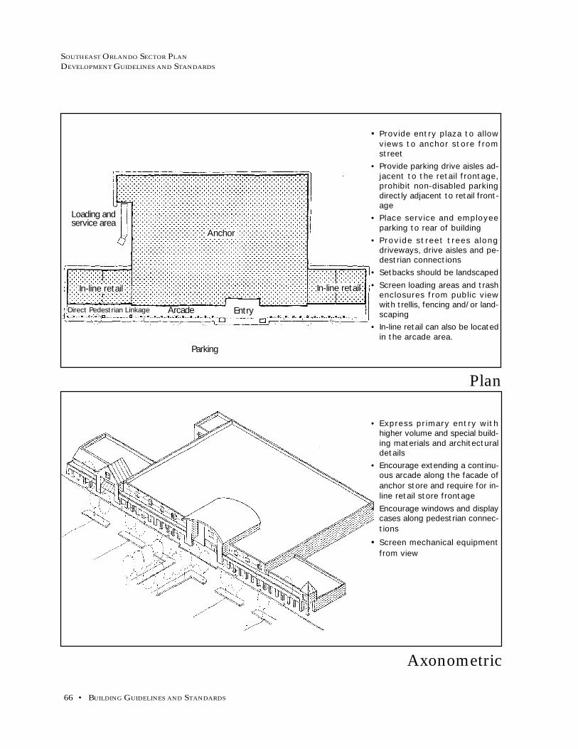
SOUTHEAST ORLANDO SECTOR PLAN
DEVELOPMENT GUIDELINES AND STANDARDS
66 • BUILDING GUIDELINES AND STANDARDS
Axonometric
Plan
• Provide entry plaza to allowviews to anchor store fromstreet
• Provide parking drive aisles ad-jacent to the retail frontage,prohibit non-disabled parkingdirectly adjacent to retail front-age
• Place service and employeeparking to rear of building
• Provide street trees alongdriveways, drive aisles and pe-destrian connections
• Setbacks should be landscaped• Screen loading areas and trash
enclosures from public viewwith trellis, fencing and/or land-scaping
• In-line retail can also be locatedin the arcade area.
• Express primary entry withhigher volume and special build-ing materials and architecturaldetails
• Encourage extending a continu-ous arcade along the facade ofanchor store and require for in-line retail store frontage
• Encourage windows and displaycases along pedestrian connec-tions
• Screen mechanical equipmentfrom view
Loading andservice area
Arcade
Parking
Entry
In-line retail
Anchor
In-line retail
Direct Pedestrian Linkage

SOUTHEAST ORLANDO SECTOR PLAN
DEVELOPMENT GUIDELINES AND STANDARDS
MAY 10, 1999 • 67
Anchor Retail and In-Line Shops
Axonometric
Plan
• Provide visitor drop-off areasand on-street parking at pub-lic building entries
• Encourage pedestrian connec-tions from parking areas tobuilding entries at publicstreets
• Locate parking to the rear ofthe building away from publicview
• Provide street trees alongdriveways, drive aisles andpedestrian connections
• Screen trash enclosures frompublic view with a fence andlandscaping
• Encourage architectural ex-pression of building entry fea-tures
• Provide roof forms such aships, gables or mansards
• Screen mechanical equipmentfrom view
• Glass curtain wall constructionand reflective glass is prohib-ited
• Minimum 2-story buildingwall along public streets
Parking lot
EntryOn-street parking

SOUTHEAST ORLANDO SECTOR PLAN
DEVELOPMENT GUIDELINES AND STANDARDS
68 • BUILDING GUIDELINES AND STANDARDS
• Emphasize major entries withspecial massing and architec-tural treatment
• Provide outdoor dining terraceswith tables, chairs, and otherfurniture to bring activity to thestreet
• Integrate signage into archi-tectural design
• Windows, display windows,and recessed panels shouldanimate all facades
• Open balconies for second flooroffice uses
• Provide roof forms such aships, gables or mansards
• Screen mechanical equipmentfrom view
• Lobby for upper floor usesshall be accessed from publicstreet
Office
Axonometric
Plan
• Provide visitor drop-off areasand on-street parking at pub-lic building entries
• Locate parking to the rear ofthe building away from publicview
• Encourage pedestrian connec-tions from parking areas tobuilding entries at publicstreets
• Minimize driveway width andpedestrian crossing distancesat sidewalk
• Provide street trees alongparking lots, driveways, driveaisles and pedestrian connec-tions
• Screen trash enclosures frompublic view with a fence andlandscaping
• Minimum 2-story building wallalong public streets is required
Entry
ParkingParking
On-Street parking
Entry

SOUTHEAST ORLANDO SECTOR PLAN
DEVELOPMENT GUIDELINES AND STANDARDS
MAY 10, 1999 • 69
Office over Ground Floor Commercial
Civic Uses and Public Facilities StandardsCivic facilities and amenities are fundamental elements of all communities. The
placement of civic buildings constitute the framework of each Town, Village, Neigh-
borhood, and Residential Center. Parks and plazas provide a public focal point for
each neighborhood and commercial center and should be placed in central and core
locations to serve as public activity areas. The Southeast Orlando Sector Plan shall
strive to place these uses in appropriate locations in each residential center for the
greatest visibility, accessibility, and utility. Civic facilities can include both public
and quasi-public uses such as daycare, postal services, community facilities,
“telecommuting” services, and other uses.
The goal of the Southeast Orlando Sector Plan shall be to provide a full and equal
level of community facilities and services for all areas of the community. The City
shall ensure that the provision of facilities is planned for in advance, rather than left
to chance, so the quality of community facilities and services is not reduced and the
fiscal integrity of the City is promoted. This shall include storm drainage, utilities,
library services, police and fire services, and other similar city services, as well as
services or facilities which are not provided by the City, such as
schools. See the Mixed-Use and Commercial Building Standards
section for additional building design and site planning issues.
Site Planning and Building Guidelines
a. Terminate Vistas. In order to reinforce the importanceof civic facilities, they shall be sited to terminate im-portant vistas within the community. For example, aconnector roadway linking a Village Center with aschool site should be terminated by a prominent build-ing on the school site and a daycare center or othercivic building within the Village Center.
b. Highlight Entries. Tower elements, arbors, gateways,or other architectural features should be used at theentries to civic buildings to reinforce the linkage be-tween the community and the civic use.
Schools
a. Adequate School Facilities. In accordance with GMPFuture Land Use Policy 4.1.16, and generally consis-tent with the location of schools shown on the South-east Orlando Sector Plan map, residential developersshall be required to provide land, or an equivalent fee-in-lieu thereof (if allowed by the City) for publicschools based on actual residential entitlements at thetime of master site plan, land subdivision or it’s ad-ministrative equivalent. High School and MiddleSchool sites should be reserved; while Elementary

SOUTHEAST ORLANDO SECTOR PLAN
DEVELOPMENT GUIDELINES AND STANDARDS
70 • BUILDING GUIDELINES AND STANDARDS
School sites shall either be donated to the City of Or-lando prior to the issuance of plat approval for resi-dential projects, or the property owner/developer maypropose alternative mechanisms for providing the re-quired school site; however any such alternativemechanism must be approved by the City of Orlandoprior to plat approval. The City supports innovativesolutions to the provision of school facilities, and shallencourage property owners/developers to coordinatewith the Orange County School Board and/or otherpublic and private entities to provide schools in South-east Orlando.
b. Joint School/Park Opportunities. The location of exist-ing and/or proposed school facilities should be coor-dinated with existing and/or proposed park sites, inorder to provide for more efficient joint use opportu-nities, wherever possible.
Storm Drainage
a. Storm Drainage Requirements. All future developmentin the Southeast Orlando planning area shall be re-quired to discharge stormwater at rates not to exceedhistoric runoff rates and volumes. Stormwater deten-tion and water quality facilities will be required for alldevelopment within the Southeast Orlando planningarea, as determined during the review process for eachdevelopment. The specifications and standards of theSoutheast Orlando Stormwater Master Plan, whencompleted, shall be followed to the greatest extent fea-sible. In the interim, development shall meet the re-quirements of the Orlando Urban Stormwater Man-agement Manual.
b. Integration with Existing Storm Drainage Systems. Ex-isting drainageways and wetlands shall be maintainedor enhanced in a natural state to the greatest extentfeasible. In lower-density areas, drainage systemsshould recharge on-site groundwater by using swalesand surface systems, rather than concrete-lined or un-derground storm drains. All urban runoff should betreated on-site with biological retention and filtrationareas.
c. Joint Use Stormwater/Open Space Opportunities. The lo-cation, function, and design of all stormwater facili-ties should be coordinated with open space and parkareas, in order to provide for joint use opportunities,wherever possible.
d. Interconnected System. Where possible, greenways withtrails should line riparian corridors and stormdrainageways connecting to destinations such as schools,
SOUTHEAST ORLANDO SECTOR PLAN
DEVELOPMENT GUIDELINES AND STANDARDS
MAY 10, 1999 • 71
Police and Fire Services
a. Plan for Future Police and Fire Services Needs. Provide forfuture police and fire protection services needs in accor-dance with the planning area’s future growth patterns.Specific consideration should be given to planning for asubstation/satellite facility to serve the new develop-ment area within the Town Center or Village Centers.The City shall identify such location(s) and shall developa master site plan.
b. Fire Sprinklers - All non-residential buildings of more than100 habitable square feet shall be equipped with firesprinklers. This requirement is necessary in order firstto optimize public safety, and second, to provide costsavings to the public and to the development commu-nity.
Transit Shelters
a. Transit Shelter Design. Transit shelters should be designedso that both passengers accessing the shelter and the busdriver have the ability to clearly see the shelter. Seatingareas, if provided, should be designed to discouragesleeping or occupancy for inappropriate lengths of time.Please refer to the following Lynx publications: “Cen-tral Florida Mobility Design Manual”, and “CustomerAmenities Manual”.
parks, and Neighborhood Centers. Coordinate an openlands system among property owners to use land effi-ciently and retain wildlife movement corridors.
Library
a. Plan for Future Library Needs. Provide for future library

72 • CIRCULATION GUIDELINES AND STANDARDS
SOUTHEAST ORLANDO SECTOR PLAN
DEVELOPMENT GUIDELINES AND STANDARDS
This section gives direction to the detailed planning of circulation
networks within individual developments and will ensure an inter-
connected system of arterial, collector, connector and local streets;
bicycle lanes; multi-use trails; transit; traffic calming; and parking
standards.
Street Sections - provides cross sections for typical roadways
detailing lane width, parking, bicycle lanes and
required right-of-way.
Bicycle Lanes - presents the recommended standards for both
on-street and off-street bicycle facilities.
Multi-Use Trails - summarizes the standards and
recommended location for paths/trails designed to
accommodate pedestrians, cyclists roller skaters
and joggers.
Transit - presents recommended bus routes and transit
shelter design.
Accessibility Index - summarizes the percent of households,
employees and mixed-use centers served by
pedestrian/bicycle facilities and transit.
Traffic Calming - summarizes a catalog of traffic calming
techniques and discusses appropriate locations and
benefits.
Parking Standards - presents a discussion of shared parking,
parking ratios, and on- and off-street parking.
CIRCULATION GUIDELINES AND STANDARDS

MAY 10, 1999 • 73
SOUTHEAST ORLANDO SECTOR PLAN
DEVELOPMENT GUIDELINES AND STANDARDS
Typical cross sections have been developed for each type of street
within Southeast Orlando. These cross-sections shall only be used
where Traditional Design land use and building standards are uti-
lized. Each cross section details lane width, medians, bicycle lanes,
parking, sidewalks, landscape areas, drainage (rural roadways),
and required right-of-way. Not all contingencies have been cov-
ered because the list would be far too large. However, cross sec-
tions can be modified to accommodate special circumstances. For
example, it may not be desirable to have a sidewalk on the side of
a roadway fronting a wetland; the appropriate cross section can be
developed by deleting the sidewalk from the cross section designed
for the particular type of roadway. Such modifications shall be
reviewed by all pertinent City departments (Planning, Fire, Police,
Solid Waste, Public Works) and must be approved by the City Plan-
ning Official and City Engineer.
Cross sections have been developed for arterials (urban and ru-
ral), mixed-use center streets (arterial and local), residential neigh-
borhood streets, residential and connector streets, and airport sup-
port district streets. Arterials are defined as major high-volume
roadways such as Narcoossee Road and Alafaya Trail. Town and
Village Center streets will be composed of arterial and local streets.
Neighborhood Center streets should be local in nature. Residen-
tial Neighborhoods shall be comprised of connector and local
streets. Residential and commercial connector streets shall pro-
vide vehicular connections between residential neighborhoods and
commercial centers. Airport Support District streets are typically
local in nature, but with a lane width and intersection radius suffi-
cient to handle large trucks.
Residential neighborhood local streets reflect the options available
for three levels of on-street parking. Whether there is no on-street
parking, limited on-street parking or unlimited on-street parking
will be determined by presence or absence of one- or two-car ga-
rages and the resulting driveway width. The specific roadway
cross-section shall be determined at the time of site plan review
based on the proposed unit types fronting the roadway.
As stated in GMP Future Land Use Policy 4.2.6, bicycle lanes should
be designed for all connector and arterial streets. Bicycle lanes are
typically 4 feet in width, and 5 feet in width when adjacent to on-
street parking. Consult the State of Florida Department of
Transportation’s Bicycle Facilities Planning and Design Manual and
the City of Orlando Bicycle Plan when designing bicycle lanes.
Street Sections

74 • CIRCULATION GUIDELINES AND STANDARDS
SOUTHEAST ORLANDO SECTOR PLAN
DEVELOPMENT GUIDELINES AND STANDARDS
The core cross sections referenced above are summarized in the fol-
lowing table and individually presented on the following pages.
An additional multi-use trail section has also been included.

MAY 10, 1999 • 75
SOUTHEAST ORLANDO SECTOR PLAN
DEVELOPMENT GUIDELINES AND STANDARDS
Bicycle Accommodation
Bicycle lanes are a portion of the roadway which has been desig-
nated for the preferential or exclusive use of the bicycle. Sidewalks
are not encouraged as substitutes for bicycle lanes. As stated pre-
viously, bicycle lanes should be designed for all connector and ar-
terial streets. The following map shows the conceptual Bicycle
Master Plan for the Southeast Orlando Sector Plan area. As with
the conceptual roadway network, the final alignments and con-
nections will be established based on individual master plan pro-
posals and environmental constraints.

76 • CIRCULATION GUIDELINES AND STANDARDS
SOUTHEAST ORLANDO SECTOR PLAN
DEVELOPMENT GUIDELINES AND STANDARDS
Bicycle Master Plan
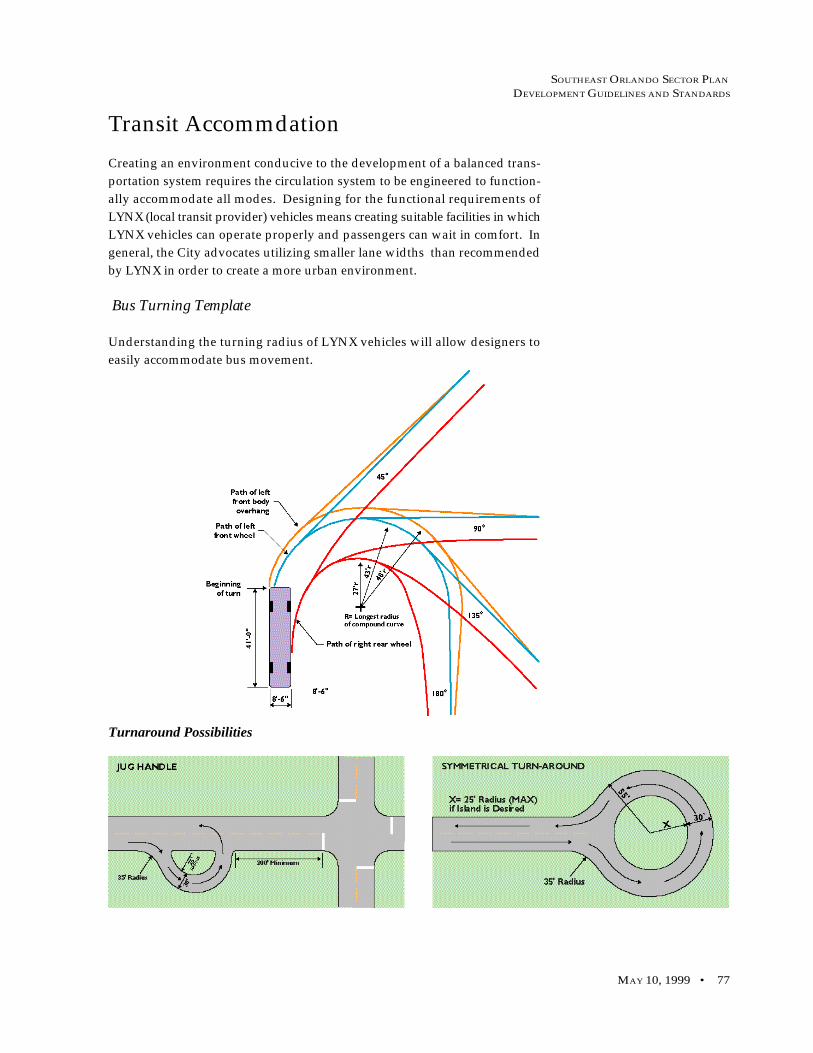
MAY 10, 1999 • 77
SOUTHEAST ORLANDO SECTOR PLAN
DEVELOPMENT GUIDELINES AND STANDARDS
Transit Accommdation
Turnaround Possibilities
Creating an environment conducive to the development of a balanced trans-
portation system requires the circulation system to be engineered to function-
ally accommodate all modes. Designing for the functional requirements of
LYNX (local transit provider) vehicles means creating suitable facilities in which
LYNX vehicles can operate properly and passengers can wait in comfort. In
general, the City advocates utilizing smaller lane widths than recommended
by LYNX in order to create a more urban environment.
Bus Turning Template
Understanding the turning radius of LYNX vehicles will allow designers to
easily accommodate bus movement.

78 • CIRCULATION GUIDELINES AND STANDARDS
SOUTHEAST ORLANDO SECTOR PLAN
DEVELOPMENT GUIDELINES AND STANDARDS
Bus Vehicle Dimensions
Vehicle dimensions are used to establish minimum functional stan-
dards. Dimensions illustrated below represent the largest vehicles
within each bus classification.
Vertical and Horizontal Clearances for Buses
In general, the City advocates utiliz-
ing smaller lane widths than rec-
ommended by LYNX in order to cre-
ate a more urban environment.

MAY 10, 1999 • 79
SOUTHEAST ORLANDO SECTOR PLAN
DEVELOPMENT GUIDELINES AND STANDARDS
Bus Turnouts:
Bus turnouts are used to facilitate traffic flow when LYNX buses
need extended layover time for transfers and scheduling. Add 50
feet for each additional bus expected to use the stop at the same
time. While turnouts are advantageous to traffic circulation, turn-
outs make it difficult for LYNX buses to reenter traffic. Contact
LYNX Planning Department on an individual project basis.
Intersection Design for Bus Turns

80 • CIRCULATION GUIDELINES AND STANDARDS
SOUTHEAST ORLANDO SECTOR PLAN
DEVELOPMENT GUIDELINES AND STANDARDS
Transit Plan

MAY 10, 1999 • 81
SOUTHEAST ORLANDO SECTOR PLAN
DEVELOPMENT GUIDELINES AND STANDARDS
Accessibility
The intent of the Southeast Orlando Sector Plan’s Transportation De-
sign Standards are to assist in creating a sustainable community with
a livable, more balanced transportation system. These standards in-
tegrate the mobility of each mode of travel into Southeast Orlando’s
community design process. This section covers four topics: pedes-
trian mobility, bicycle mobility, transit mobility, roadways, and ve-
hicle mobility.
Incorporating sound transportation design standards into the South-
east Orlando Sector Plan will facilitate the creation of a sustainable
community with a more balanced transportation system. This Ac-
cessibility Index analysis documents potential success of the pro-
posed transportation design standards.
Pedestrian Mobility
Southeast Orlando planners focused on walking as an essential mode
of transportation. Pedestrians travel is the basic building block in
developing a balanced transportation system. Pedestrian mobility
is decided as “distances individuals are willing to walk.” The aver-
age pedestrian travels at 3 mph. At that speed a pedestrian can cover
distances from a quarter mile to a half mile in a five to ten minute
walk.
Southeast Orlando’s pedestrian design standards improve pedes-
trian mobility through the provision of facilities which shorten walk-
ing distances, increase pedestrian accessibility to various land uses,
provide improved internal pedestrian circulation in village and town
designs, and encourage the creation of a “park once” environment,
where individuals can comfortably walk and not consider using the
auto for trips other than for their arrival and departure.
Many design elements for pedestrians are incorporated into design
standards to improve the quality of the pedestrian environment.
These include: standards which influence the location of buildings
or block standards (shortening walking distance); landscape stan-
dards and building (which make a walk more enjoyable); and, road-
way standards (slowing traffic and encouraging pedestrian activ-
ity).
Site design elements also include multiple points of pedestrian ac-
cess to the street network, encouraging pedestrian activity. Mixing
of retail, office, and residential uses in a dense, compact space also
encourages a pedestrian-based transportation system. Mixed used

82 • CIRCULATION GUIDELINES AND STANDARDS
SOUTHEAST ORLANDO SECTOR PLAN
DEVELOPMENT GUIDELINES AND STANDARDS
environments of this type, in combination with attractive
streetscapes and pedestrian friendly design, help create higher per-
centage of trips which are pedestrian based.
Transit Mobility
Southeast Orlando’s community design allows transit convenient
access to community centers, provides direct routes, and locates
stops where they have high pedestrian access. Direct transit rout-
ing will reduce the operational cost of providing service. Circui-
tous routes increase the number of miles and hours of operation,
increasing costs. Indirect routing discourages transit ridership
through time delays and limitations to pedestrian access.
Traditionally, transit services have located along main arterials
because the arterials provide direct convenient access to many com-
munity destinations. A transit routing system was developed
which strikes a blend between directness-of-service and transit ac-
cessibility objectives throughout the mixed use centers. Although
the developed plan is not based on an arterial roadway system,
the connectivity of neighborhood, village, and town centers en-
ables direct, central routing.
Indirect transit routing is often the only available means of serv-
ing automobile-induced urban sprawl. The Southeast Orlando
Sector Plan overcomes the limitations of automobile-oriented de-
sign through dense, mixed-use nodal development and good street
connectivity, thereby avoiding the need for inefficient, indirect rout-
ing. The Southeast Orlando Sector Plan provides street connec-
tions in all major directions to and from centers. The proposed
well-connected street system offers the opportunity to route tran-
sit directly through a series of communities, or town centers, serv-
ing more residents and providing more convenient service. Com-
plete street systems bring all travel origins and destinations closer
together. Therefore, trips to or from a transit stop are shorter and
more convenient.
Bicycle Mobility
Bicycles provide an alternative form of travel which effectively
quadruples the speed and provides sixteen times the coverage area
of pedestrian travel. The Southeast Orlando Sector Plan promotes
the bicycle as a viable transportation mode in a balanced
transportation system. Consideration of the needs of bicycles will
be an important component in the review of individual project
master plans.

MAY 10, 1999 • 83
SOUTHEAST ORLANDO SECTOR PLAN
DEVELOPMENT GUIDELINES AND STANDARDS
A network of bike routes, lane(s), and multi-use trails are included
in the Southeast Orlando design. The objectives considered in
the placement of network links were 1) connectivity between resi-
dential areas and activity centers, 2) local resident accessibility to
the network, and 3) ecological constraints, primarily infringement
on wetland areas. A geographic information systems analysis was
utilized in an attempt to quantify the first two points.
Multiple bicycle routes were provided, allowing higher percent-
ages of the population access to safe, alternative modes of trans-
portation. Bicycle routes were designed to provide the most di-
rect and convenient service possible.
Interconnection of bicycle facilities within the transit system was
considered in bike network design. Improving bicycle linkages
and promoting “bike and ride” are among the most cost-effective
approaches to increasing transit ridership. Bicycles provide a
strong feeder mode for premium transit, and the potential bicycle
travelshed fills gaps provided by a feeder bus service.
Vehicular Mobility
The Southeast Orlando Sector Plan is designed to integrate the
needs of the automobile with the needs of transit, walking, and
biking into their vehicular circulation system. This integration
will provide a well-connected street system and detailed street
designs that make them usable for all types of travel.
Street connections in all major directions from neighborhood,
town, and village centers are components of a complete street sys-
tem which brings all travel origins and destinations closer together.
Inevitably, driving time will be reduced. Quite possibly, good street
connectivity will induce mode shifts to alternative forms of trans-
portation, such as transit, bicycle, and pedestrian modes. Trips to
and from transit stops are shorter and more convenient due to a
completed, cohesive street system.
Overall, the street network design reflects the objective of creat-
ing streets which serve vehicular traffic as well as pedestrians,
bicyclist, and transit riders.
Having a wide variety of street design features can be implemented
as a way to make streets usable for all travel. Measures termed
“Neighborhood Traffic Control”, or “Livable Streets” are based
on ability to slow vehicle speeds, provide drivers with awareness
of other users, and buffer pedestrians from traffic flow. The ulti-
mate objective of the Southeast Orlando Sector Mobility Plan is to

84 • CIRCULATION GUIDELINES AND STANDARDS
SOUTHEAST ORLANDO SECTOR PLAN
DEVELOPMENT GUIDELINES AND STANDARDS
enable residents to achieve many destinations through alterna-
tive modes of transportation, not through moving faster, or fur-
ther, in a single mode.
Study Results
A geographic information system was used in order to quantify
the transit and bicycle mobility characteristics of the proposed
development. Design elements taken from the Southeast Or-
lando development program (i.e. number of dwelling units,
population, employment) were converted to person trip ends,
and coded into a geographic database. The proposed bicycle
and transit networks were digitized, and overlayed by the pro-
posed development zones. “Buffers”, or one-quarter mile
boundaries, were formed around both networks; these bound-
aries were then spatially “intersected” with the geographic da-
tabase.
The Geographic Information System analysis output demon-
strates that approximately three quarters of all population and
employment are accessible via a specifically designated bicycle
facility. Of course, bicyclists have the same rights as automo-
biles to the entire street network effectively making 100% of the
development area accessible by bicycle. Significantly less em-
ployment and population are served by transit; this figure, how-
ever, reflects a tradeoff between accessibility and directness, and
may increase significantly with slightly less direct routing.
Access to Jobs and Housing via Bike and Transit
Employees Households Town Center Village Center Neighborhood Served Served Served Served Center Served
Bicycle 75% 76% 100% 100% 78%Transit 58% 56% 100% 100% 63%
Connectivity Index
Accessibility and connectivity are complementary concepts. In
accordance with GMP Future Land Use Policy 4.2.5, and consis-
tent with the GMP Transportation Element, the City shall com-
bine the mobility of the traditional interconnected street pattern
with the safety, security, and topographic sensitivity of the con-
ventional or contemporary network. Such a hybrid network
features short, curved stretches that follow the lay of the land or
contribute to good urban design, as well as short loops and cul-
de-sacs, so long as the higher-order street network is left intact.

MAY 10, 1999 • 85
SOUTHEAST ORLANDO SECTOR PLAN
DEVELOPMENT GUIDELINES AND STANDARDS
Traffic calming devices have potential use in both the design of new road
segments in Southeast Orlando, as well as the modification of existing roads,
or the future modification of roads initially built without traffic calming
features. Five groups of traffic calming devices are appropriate for use in
Southeast Orlando:
1. Street narrowing;
2. Vehicle deflection (traffic diversion);
3. Pavement sharing;
4. Rerouting; and,
5. Pavement surface treatments.
Traffic Calming
“Higher-order” means arterials, collectors, and sub-collectors that carry
through traffic. An acceptable individual project master plan may feature
interrupted grids of short street ending at T or Y intersections, traffic circles
or squares/parks. By design, local streets may carry some through-traffic,
but the truncated nature of local streets means that traffic moves more slowly
and the heaviest volumes are diverted to higher-order streets.
A simple measure of connectivity is the number of street links divided by
the number of nodes or link ends (including cul-de-sac heads). The more
links relative to nodes, the more connectivity. A connectivity index of 1.4
to 1.8 represents an acceptable street network in the Southeast Plan area.
The optimal connectivity index for a perfect grid network is 2.5. This is the
procedure for calculating the connectivity index:
1. Count the number of nodes. Nodes are any point of intersection of
two or more roads or any cul-de-sac ends. There are 8 nodes in the
example (counting only the black nodes).
2. Count the number of links. Links are the segments of road con-
necting nodes. To properly calculate the connectivity index, you
must include the first link beyone the last nodes. There are 12 links
in the example (ignoring the dashed lines).
3. Use the following formula to calculate the connectivity index: links/
nodes = connectivity index. The connectivity index of the example is
12/8 = 1.5.This connectivity index can be improved by
removing the cul-de-sacs and connecting the
street-ends to other streets (follow the dashed
lines). There are still 8 nodes (counting the
clear circles and ignoring the black cul-de-sac
circles), but there are now 14 links. The index
is now 1.8. Simple changes in design can bring
about significant changes in connectivity in-
dex scoring. The City shall utilize the con-
nectivity index mechanism, in addition to
other qualitative measures, to determine
whether transportation impact fees can be
reduced within the Southeast Plan area.

86 • CIRCULATION GUIDELINES AND STANDARDS
SOUTHEAST ORLANDO SECTOR PLAN
DEVELOPMENT GUIDELINES AND STANDARDS
Street Narrowing
A low cost method of street narrowing is to stripe roadway lanes to
a maximum width of nine to eleven feet. Where roads are wider
then 24 feet, this has the added benefit of providing space for bi-
cycle lanes on each side of the roadway.
Another low cost way to narrow the street is to allow parking on
one or both sides of the roadway. On-street parking reduces speed
noticeably, by effectively “narrowing” the street. The parking can
be staggered to create a weaving path on the roadway, further in-
forming drivers that caution should be used in this neighborhood.
“Bulbouts” -- Short sections of narrowed street appear to narrow
the entire street, yet permit a normal amount of on-street parking.
Bulbouts can be placed at intersections or at mid-block locations.
Gateways appear to narrow the street, and also serve as highly vis-
ible entryways into neighborhoods. Gateway features can also
double as transit waiting areas.
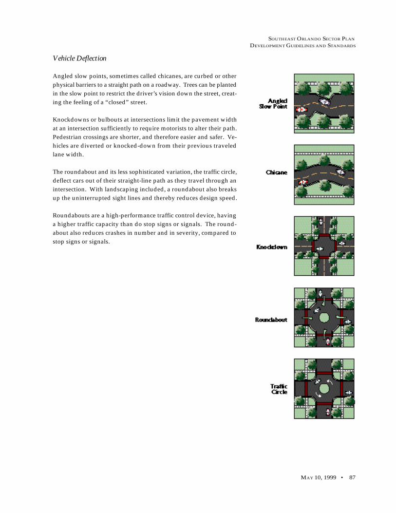
MAY 10, 1999 • 87
SOUTHEAST ORLANDO SECTOR PLAN
DEVELOPMENT GUIDELINES AND STANDARDS
Vehicle Deflection
Angled slow points, sometimes called chicanes, are curbed or other
physical barriers to a straight path on a roadway. Trees can be planted
in the slow point to restrict the driver’s vision down the street, creat-
ing the feeling of a “closed” street.
Knockdowns or bulbouts at intersections limit the pavement width
at an intersection sufficiently to require motorists to alter their path.
Pedestrian crossings are shorter, and therefore easier and safer. Ve-
hicles are diverted or knocked-down from their previous traveled
lane width.
The roundabout and its less sophisticated variation, the traffic circle,
deflect cars out of their straight-line path as they travel through an
intersection. With landscaping included, a roundabout also breaks
up the uninterrupted sight lines and thereby reduces design speed.
Roundabouts are a high-performance traffic control device, having
a higher traffic capacity than do stop signs or signals. The round-
about also reduces crashes in number and in severity, compared to
stop signs or signals.

88 • CIRCULATION GUIDELINES AND STANDARDS
SOUTHEAST ORLANDO SECTOR PLAN
DEVELOPMENT GUIDELINES AND STANDARDS
Pavement Sharing
The mid-block single-lane yield point reduces the street width to a
single lane for a short section at some point between intersections.
A variety of designs are possible for the remaining single lane of
traffic: it can be centered in the existing street, offset to one side or
the other of the street, or aligned in a curve from one side of the
street to the other.
Landscaping at mid-block yield points can screen the view along
the street, not only for drivers but also for pedestrians and resi-
dents of the street. This blocking of the view reduces vehicle speeds
for several hundred feet to either side of the yield point. Further,
the blocking of the view can screen out unappealing views, such
as nearby cross streets and buildings along them.
At the intersection yield point, the street is narrowed through an
intersection or some of its approaches. The intersection yield point
allows only a single vehicle at a time to negotiate the intersection.
Approaching drivers interact with each other, and reach an under-
standing on taking or yielding the right-of -way through the inter-
section.
On many streets, allowing on-street parking will crate a series of
single-lane yield points wherever parked cars are present. This
“informal” single-lane yield point occurs when the street width is
narrow enough to prevent simultaneous passing of two moving
vehicles past a parked vehicle. For streets of up to about 26 feet in
width, a parked vehicle on one side will create, for most drivers, a
single-lane yield point. For streets up to about 30 feet in width,
parked vehicles on both sides will create a single-lane yield point
in the remaining unused street width.

MAY 10, 1999 • 89
SOUTHEAST ORLANDO SECTOR PLAN
DEVELOPMENT GUIDELINES AND STANDARDS
Rerouting
A diagonal road closure forces turns to be made at certain points,
eliminating some (or even all) direct routes through a neighbor-
hood. This can be effective with cut-through traffic. Access to
homes is still maintained from more than one direction, allowing
the local roadway network to continue to carry local traffic. A
diagonal road closure can be a continuous strip connecting cor-
ners with landscape maintained by the city or by adjacent prop-
erty owners.. It can also consist of several barriers (bollards, cir-
cular planters) that allow pedestrian, bicycle and moped access
through the barrier. This provides an incentive to use bicycle for
travel as it does not have the same constraints to movement
through the network as do the automobiles.
Forced turn barriers can also be used to change the route through
a neighborhood. These allow vehicular traffic on a through street
to remain unchanged, and at the same time force traffic from the
side street to the through street. Partial road closures physically
block one direction of a two-way street. For instance, one could
drive through an intersection away from a community, but could
not return by that same route.

90 • CIRCULATION GUIDELINES AND STANDARDS
SOUTHEAST ORLANDO SECTOR PLAN
DEVELOPMENT GUIDELINES AND STANDARDS
Pavement Surface Treatments
Textured pavement such as brick streets are also an effective traffic
calming device. The advantages of a brick street are that it is aes-
thetically pleasing and it calms traffic better as it ages, as tree roots
“push-up” bricks and as the surface wears out. However, textured
pavement can be loud and costs significantly more than asphalt
roadways.
Raised intersections slow cars down throughout an entire inter-
section. This provides an extra level of safety for pedestrians cross-
ing at an intersection. This improvement may be most appropri-
ate in commercial areas where the traffic volumes are high. Tex-
tured pavement can also be a part of this improvement.

MAY 10, 1999 • 91
SOUTHEAST ORLANDO SECTOR PLAN
DEVELOPMENT GUIDELINES AND STANDARDS
The following standards shall apply in Town, Village, Neighborhood
and Residential Centers and may be used as design guidelines in other
districts.
Joint Access
Cross access easements or similar mechanisms shall be used to provide
joint access between the parking areas of adjacent properties. This will
preclude drivers from having to use the street network to access a neigh-
boring parcel.
Shared Parking
Shared parking may be provided for multiple uses where it can be dem-
onstrated that due to different use time frames the minimum amount of
required parking will be available for each use. For example, land uses
such as movie theaters and restaurants can share office parking space
during the evening hours.
Off-Site Parking
Off-site parking, including on-street parking may be utilized to meet
minimum parking requirements as long as reasonable pedestrian ac-
cess is provided from the parking space to the use.
Parking Access
Parking areas shall be accessed from side and back streets and from
adjacent properties. Access from the front street shall be avoided un-
less no other reasonable access is available. Block standards for Town,
Village, Neighborhood, and Residential Centers require a minimum of
65% street frontage therefore, forcing parking to the sides and rear of
buildings.
Pedestrian Access
A direct pedestrian access shall be provided from the public sidewalk
network to the primary building entrance without having to cross a
vehicular travelway.
Landscaping/Screening
Parking areas shall be landscaped consistent with Chapter 60 of the
Land Development Code. Connecting walkways should be land-
scaped with either shade trees or climbing vines on trellises.
Parking Standards and Design

92 • CIRCULATION GUIDELINES AND STANDARDS
SOUTHEAST ORLANDO SECTOR PLAN
DEVELOPMENT GUIDELINES AND STANDARDS
On-Street Parking
On-street parking shall be utilized in mixed-use centers whenever
and wherever possible. On-street parking areas shall be differen-
tiated from road travel lanes through the use of texture paving or
textured paving strips.


SOUTHEAST ORLANDO SECTOR PLAN
DEVELOPMENT GUIDELINES AND STANDARDS
MAY 10, 1999 • 93
OPEN SPACE GUIDELINES AND STANDARDS
Recreational Open Space
Park Distribution and General Requirements
Public parks in Southeast Orlando can be divided into three cat-
egories. Community Parks provide facilities that serve the needs
of greater Southeast Orlando, such as organized playing fields,
swimming pools, amphitheaters, tennis and basketball complexes,
and larger picnic areas. Neighborhood parks, by contrast, provide
local centers of activity and recreation immediately accessible to
residents, and include modest amenities such as tot-lots, small hard-
surface courts, multi-purpose lawn areas, and informal natural
settings. Village Greens and Plazas provide a place to focus civic
activity at the center of town or a neighborhood. Park acreage
should be distributed to provide adequate facilities throughout the
community while emphasizing neighborhood recreation within
walking distance of most residents. See also Parks/Open Space
Landscape Design Standards.
Distribution of Parks
a. Distribution. To avoid extraordinary and potentialdebilitating demands on existing parks, new parksmust be available to residents as they move into newlydeveloped areas. To satisfy this requirement for newparks, all new development shall meet the followingpark dedication or cash in lieu of dedication require-ments:
b. The City’s current LOS standard of 3.25 acres/1000population shall be maintained in Southeast Orlando.At least 2.05 acres/1000 population shall be in func-tional community and neighborhood parks. The re-maining 1.2 acres/1000 population may be made upof village greens and plazas, conservation buffers andthe Primary Conservation Network if such areas arevisually accessible by the general public (not privatebackyards).

SOUTHEAST ORLANDO SECTOR PLAN
DEVELOPMENT GUIDELINES AND STANDARDS
94 • OPEN SPACE GUIDELINES AND STANDARDS
Location of Parks
a. Greens and Plazas. At least one Green and/or Plazashould be provided within all Town, Village, Neigh-borhood and Residential Centers, unless served by aNeighborhood Park. Greens and Plazas should alsobe included in the mixed-use components in the Air-port Support District-Medium Intensity.
b. Neighborhood Parks. Neighborhood Parks should bedistributed throughout neighborhoods, to allow aminimum of 60% of the residents to be within 1/3 to1/4 mile of a local park. Most users should not needto cross any arterial streets to get to the park. Wherepossible, Neighborhood Parks should be shared withelementary schools and should connect with the trailand greenway network.
c. Community Parks. Sites for community parks shouldbe distributed to allow each major area within theSoutheast Orlando to be within bicycling or drivingdistance of an active recreation area. Where possible,link these sites and their facilities with the trail andgreenway network.
Recommended Park Program
In general, park areas should include sufficient trees to provide
shaded areas. Existing vegetation should be saved where appro-
priate.
a. Greens and Plazas. Greens and Plazas should provideopportunities for public gathering, such as:
• multi-purpose lawn areas,
• tot lots,
• informal picnic areas,
• amphitheaters,
• raised stages and gazebos,
• larger hardscaped areas, and
• seating.
b. Neighborhood Parks. Neighborhood Parks should pro-vide modest and flexible recreation opportunities thatmeet basic neighborhood needs and accommodatemultiple purposes. Recommended features include:
• multi-purpose lawn areas,
• tot lots,
• small court game areas,
• community gardens,
• informal picnic areas, and
• seating.
Green at Mizner Park in Boca Raton, Florida
Plaza at Mizner Park in Boca Raton, Florida
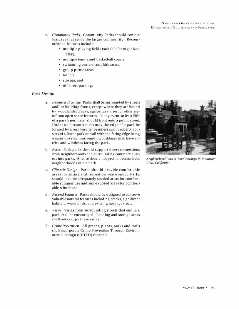
SOUTHEAST ORLANDO SECTOR PLAN
DEVELOPMENT GUIDELINES AND STANDARDS
MAY 10, 1999 • 95
c. Community Parks. Community Parks should containfeatures that serve the larger community. Recom-mended features include:
• multiple playing fields (suitable for organized
play),
• multiple tennis and basketball courts,
• swimming centers, amphitheaters,
• group picnic areas,
• tot lots,
• storage, and
• off-street parking.
Park Design
a. Perimeter Frontage. Parks shall be surrounded by streetsand/or building fronts, except where they are boundby woodlands, creeks, agricultural uses, or other sig-nificant open space features. In any event, at least 50%of a park’s perimeter should front onto a public street.Under no circumstances may the edge of a park beformed by a rear yard fence unless such property con-sists of a linear park or trail with the facing edge beinga natural system; surrounding buildings shall have en-tries and windows facing the park.
b. Paths. Park paths should support direct connectionsfrom neighborhoods and surrounding commercial ar-eas into parks. A fence should not prohibit access fromneighborhoods into a park.
c. Climatic Design. Parks should provide comfortableareas for sitting and recreation year-round. Parksshould include adequately shaded areas for comfort-able summer use and sun-exposed areas for comfort-able winter use.
d. Natural Features. Parks should be designed to conservevaluable natural features including creeks, significanthabitats, woodlands, and existing heritage trees.
e. Views. Vistas from surrounding streets that end in apark shall be encouraged. Loading and storage areasshall not occupy these vistas.
f. Crime Prevention. All greens, plazas, parks and trailsshall incorporate Crime Prevention Through Environ-mental Design (CPTED) concepts.
Neighborhood Park at The Crossings in MountainView, California
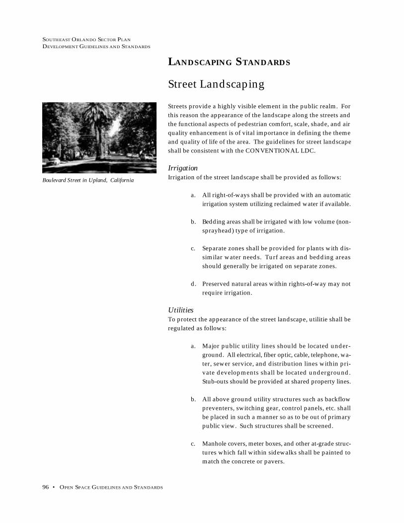
SOUTHEAST ORLANDO SECTOR PLAN
DEVELOPMENT GUIDELINES AND STANDARDS
96 • OPEN SPACE GUIDELINES AND STANDARDS
LANDSCAPING STANDARDS
Street Landscaping
Streets provide a highly visible element in the public realm. For
this reason the appearance of the landscape along the streets and
the functional aspects of pedestrian comfort, scale, shade, and air
quality enhancement is of vital importance in defining the theme
and quality of life of the area. The guidelines for street landscape
shall be consistent with the CONVENTIONAL LDC.
IrrigationIrrigation of the street landscape shall be provided as follows:
a. All right-of-ways shall be provided with an automatic
irrigation system utilizing reclaimed water if available.
b. Bedding areas shall be irrigated with low volume (non-
sprayhead) type of irrigation.
c. Separate zones shall be provided for plants with dis-
similar water needs. Turf areas and bedding areas
should generally be irrigated on separate zones.
d. Preserved natural areas within rights-of-way may not
require irrigation.
UtilitiesTo protect the appearance of the street landscape, utilitie shall be
regulated as follows:
a. Major public utility lines should be located under-
ground. All electrical, fiber optic, cable, telephone, wa-
ter, sewer service, and distribution lines within pri-
vate developments shall be located underground.
Stub-outs should be provided at shared property lines.
b. All above ground utility structures such as backflow
preventers, switching gear, control panels, etc. shall
be placed in such a manner so as to be out of primary
public view. Such structures shall be screened.
c. Manhole covers, meter boxes, and other at-grade struc-
tures which fall within sidewalks shall be painted to
match the concrete or pavers.
Boulevard Street in Upland, California
SOUTHEAST ORLANDO SECTOR PLAN
DEVELOPMENT GUIDELINES AND STANDARDS
MAY 10, 1999 • 97
Street Trees
a. Selection. Plant materials selected to meet the require-
ments for street tree planting shall be consistent with the
CONVENTIONAL LDC. Plantings should be selected
based on soil conditions, water requirements, surround-
ing environment, and intended theme and are subject to
review and approval by the City.
b. Spacing. In order to develop a positive pedestrian envi-
ronment, and consistent with GMP Future Land Use
Policy 4.1.17, required street trees shall be spaced accord-
ing to species type and in accordance with the require-
ments of the CONVENTIONAL LDC.
SOUTHEAST ORLANDO SECTOR PLAN
DEVELOPMENT GUIDELINES AND STANDARDS
98 • OPEN SPACE GUIDELINES AND STANDARDS
Protected Habitats
Exotic species shall be precluded from natural areas left as Con-
servation Use areas, and from landscaped areas adjacent to these
features to the maximum extent possible. Management for these
areas should be aimed at sustaining the integrity of preserved natu-
ral systems. Design concepts that should be considered to prevent
the encroachment of exotic, or nuisance vegetation into areas in-
tended to remain natural include the following:
a. Naturally-vegetated buffers shall be preserved adja-
cent to conservation areas consistent with the GMP
Conservation Element.
In residential areas, restrictions should be placed
within Homeowner Organization criteria to ensure
compliance with buffer requirements. Further,
homeowners should be educated about the potential
impacts to preserved habitats from inappropriate uses
of pesticides, herbicides, and fertilizers.
b. Conservation easements may be developed for natu-
ral preserves which minimize human disturbance ex-
cept for the purposes of education, or passive recre-
ation with a focus on natural resources.
c. The natural processes that sustain the functions of pre-
served areas should be considered in landscape main-
tenance plans. This should include the maintenance
of pre-development wetland hydroperiods, patterns
of fire, and nutrient loads to the maximum extent pos-
sible.
d. Native plant materials shall be used in landscape plans
wherever possible. Non-native materials should con-
sist of plants that are shown not to invade natural land-
scapes, and comply with CONVENTIONAL LDC.
e. Incompatible land uses should not be allowed adja-
cent to preserved natural areas. These land uses in-
clude development types that are likely to result in
environmental contamination, a change in wetland
hydroperiod, or an adverse impact to the quality of
receiving waterbodies.
General Landscaping Guidelines
SOUTHEAST ORLANDO SECTOR PLAN
DEVELOPMENT GUIDELINES AND STANDARDS
MAY 10, 1999 • 99
f. Potential sources of exotic vegetation should be kept
under control to prevent the spread of undesirable
species into conservation areas. For example, cattails
(Typha sp.) should be controlled in retention ponds
before seeds disperse into adjacent areas. In many in-
stances, this is most effectively done by planting re-
tention ponds to desirable species at the time of con-
struction.
Water Conservation Guidelines
a. Planning and Design. Planning is the most important
step to a successful water conserving landscape. All
landscape and irrigation plans for non-residential de-
velopments, multifamily residential, public parks and
open spaces shall be designed by a Landscape Archi-
tect, registered to practice in the State of Florida.
For residential, many homeowners create their own
designs with excellent results. Landscape profession-
als may also serve as helpful resources. They can pro-
vide advice, critique, and/or develop plans.
b. Preservation of Existing Vegetation. Existing vegetation
should be incorporated into the design of parks and
open space. The edge of these areas should be mulched
with appropriate organic mulches. Cypress mulch
should not be use.
c. Soil improvements. Soil improvements allow for better
absorption of water and improved water-holding ca-
pacity of the soil. Soils that have organic matter also
provide beneficial nutrients to plants. Soils should be
improved prior to the installation of any irrigation
system. Soil additives should be added to planting
areas to reduce water demand.
d. Efficient Irrigation. Well planned irrigation/sprinker
systems can save significant amounts of water. For
efficient water use, irrigate turf areas separately from
other plantings. Landscape plantings should also be
grouped according to similar water needs. Turf is best
watered with sprinklers. Trees, shrubs, flowers, and
ground covers can be watered efficiently with low
volume drip, spray, or bubbler emitters.

SOUTHEAST ORLANDO SECTOR PLAN
DEVELOPMENT GUIDELINES AND STANDARDS
100 • OPEN SPACE GUIDELINES AND STANDARDS
e. Practical Turf Areas. Locate turf only in areas where it
provides functional benefits. Turf is best separated
from planting of trees, shrubs, groundcovers, and flow-
ering plants so that it may be irrigated separately.
Often turf can be replaced with other, less water de-
manding materials, such as groundcovers, low water
demand plants, or mulches. Turf serves to slow run-
off from landscape areas and should be practically
placed in areas such as swales, recreational areas, and
area of high pedestrian use.
The amount of recreation/open space areas planted
in ornamental landscape and turf should be limited
so that a portion of the site may have existing vegeta-
tion or replanted natural areas.
f. Drought-Tolerant Plants. Utilize low water use plants
in the design of landscaping. Plantings should relate
to the existing adjacent plant associations and exist-
ing soil conditions. Drought-tolerant turf grasses
should be utilized.
g. Mulch. Mulched planting beds should be utilized as a
replacement for turf areas. Mulches cover and cool
soil, minimize evaporation, reduce weed growth, and
slow erosion. Acceptable organic mulches include bark
chips, wood grindings, or pine straw. Place mulch di-
rectly on the soil or on breathable or biodegradable
material. Avoid using sheet plastic in planting areas.
Cypress mulch should not be used.
h. Maintenance. Regular maintenance preserves the in-
tended beauty of the landscape and saves water. Wa-
ter conservation designs can help reduce maintenance
costs. Proper mowing, pruning and weeding, limited
fertilization, pest control and irrigation system use
further water savings.

SOUTHEAST ORLANDO SECTOR PLAN
DEVELOPMENT GUIDELINES AND STANDARDS
MAY 10, 1999 • 101
Starter Landscaping
To improve the appearance from the street, new residential develop-
ment shall include a minimum starter package for landscaping. At a
minimum, these starter packages should include: turf grass, shrubbery,
at least one street tree, a front yard tree, and an efficient irrigation sys-
tem necessary to sustain the vegetation.
Fencing and Wall Standards
a. Two types of fences are allowed within residential areas:
“picket” fences and “privacy” fences.
Front Yard
1. Picket fences shall be not more than 3 foot-6 inchesin height. Picket fences shall not be solid and mustbe at least 50% opaque above 30 inches in height.
2. A possible alternative to a picket fence is a hedgewhich shall be maintained at a maximum heightof not more than 3 foot-6 inches. A trellis, gate, orarbor shall be exempt from the maximum heightwhen located where the walk (from the publicsidewalk to the porch) passes through the fence orhedge.
3. Picket fences or hedges can be located at the backof sidewalks along the front or street side of a lot.They may also be located along the alley to giveprivacy to an ancillary unit yard, with a minimumsetback of 10 feet from the rear property line.
Read and Side Yard
4. Privacy fences shall be not more than 6 feet inheight and may be located along interior lot linesto within 5 feet of the front facade of the principlebuilding. Fences in the street side yard shall besubject to the requirements of front yard fencing.
b. All fencing shall be built out of attractive, long-lasting ma-
terials, such as wood, PVC, masonry, stone, wrought iron,
aluminum, vinyl or vinyl-coated wire.
Residential Landscaping

SOUTHEAST ORLANDO SECTOR PLAN
DEVELOPMENT GUIDELINES AND STANDARDS
102 • OPEN SPACE GUIDELINES AND STANDARDS
c. Fences visible from public streets shall be constructed
of durable material and be detailed to include a dis-
tinctive cap/coping: columns of pilasters can also be
used to provide detail. Chainlink, whether vinyl
coated or galvanized, is prohibited for fences or walls
that are visible from public streets.
d. With masonry fences, the use of exposed or unfin-
ished/unpainted concrete block is prohibited. For
wood fences, the unfinished side shall not be visible
from public streets.
e. Screening of loading areas, refuse areas, transformers,
heating units and other ground-mounted equipment
shall be consistent with the Land Development Code.
f. Crime Prevention Through Environmental Design
(CPTED) shall be considered. Landscaping should not
create blind spots or hiding spots, particularly between
the driveway or street sidewalk and the primary en-
trance of a residential structure. Properly maintained
landscaping should provide maximum viewing to and
from the house. The street address should be clearly
visible from the street with numbers a minimum of 5
inches high that are made of non-reflective material
that provides significant contrast to the affixed back-
ground.

SOUTHEAST ORLANDO SECTOR PLAN
DEVELOPMENT GUIDELINES AND STANDARDS
MAY 10, 1999 • 103
Non-Residential Landscaping
Screening and Buffer Standards
a. Mixed-Use Buffers. In town centers, village centers, and
neighborhood centers, no supplemental buffers shall
be required between office/commercial/residential
uses.
b. Airport Support District Buffers. Where Airport Sup-
port District uses abut residential, buffer yards shall
in general be required as outlined in the City of Or-
lando Land Development Code. However, the City
may require that areas zoned PD contain more strin-
gent buffers. Such conditions shall be made part of
individual PD ordinances.
Fencing and Wall Standards
Fences and walls shall be used consistent with the CONVEN-
TIONAL LDC. CPTED shall be considered in the design of fences
and walls.
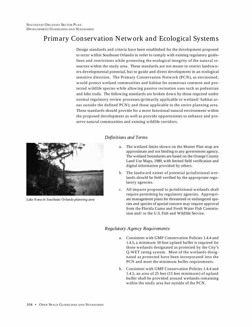
SOUTHEAST ORLANDO SECTOR PLAN
DEVELOPMENT GUIDELINES AND STANDARDS
104 • OPEN SPACE GUIDELINES AND STANDARDS
Primary Conservation Network and Ecological Systems
Design standards and criteria have been established for the development proposed
to occur within Southeast Orlando in order to comply with existing regulatory guide-
lines and restrictions while protecting the ecological integrity of the natural re-
sources within the study area. These standards are not meant to restrict landown-
ers developmental potential, but to guide and direct development in an ecological
sensitive direction. The Primary Conservation Network (PCN), as envisioned,
would protect wetland communities and habitat for numerous common and pro-
tected wildlife species while allowing passive recreation uses such as pedestrian
and bike trails. The following standards are broken down by those required under
normal regulatory review processes (primarily applicable to wetland/habitat ar-
eas outside the defined PCN); and those applicable to the entire planning area.
These standards should provide for a more functional natural environment within
the proposed development as well as provide opportunities to enhance and pre-
serve natural communities and existing wildlife corridors.
Definitions and Terms
a. The wetland limits shown on the Master Plan map areapproximate and not binding to any government agency.The wetland boundaries are based on the Orange CountyLand Use Maps, 1989, with limited field verification anddigital information provided by others.
b. The landward extent of potential jurisdictional wet-lands should be field verified by the appropriate regu-latory agencies.
c. All impacts proposed to jurisdictional wetlands shallrequire permitting by regulatory agencies. Appropri-ate management plans for threatened or endangered spe-cies and species of special concern may require approvalfrom the Florida Game and Fresh Water Fish Commis-sion and/or the U.S. Fish and Wildlife Service.
Regulatory Agency Requirements
a. Consistent with GMP Conservation Policies 1.4.4 and1.4.5, a minimum 50 foot upland buffer is required forthose wetlands designated as protected by the City’sQ-WET rating system. Most of the wetlands desig-nated as protected have been incorporated into thePCN and meet the minimum buffer requirements.
b. Consistent with GMP Conservation Policies 1.4.4 and1.4.5, an area of 25 feet (15 feet minimum) of uplandbuffer shall be provided around wetlands remainingwithin the study area but outside of the PCN.
Lake Nona in Southeast Orlando planning area

SOUTHEAST ORLANDO SECTOR PLAN
DEVELOPMENT GUIDELINES AND STANDARDS
MAY 10, 1999 • 105
c. Roads or infrastructure crossings through wetlandsystems shall be limited to the narrowest point of thewetland.
Storm Drainage
a. Storm Drainage Requirements. All future developmentin the Southeast Orlando planning area shall be re-quired to discharge stormwater at rates not to exceedhistoric runoff rates and volumes. Stormwater deten-tion and water quality facilities will be required for alldevelopment within the Southeast Orlando planningarea, as determined during the review process for eachdevelopment. The specifications and standards of theSoutheast Orlando Stormwater Master Plan, whendeveloped, shall be followed to the greatest extent fea-sible. In the interim, the City’s OUSWMM standardsshall apply.
b. Integration with Existing Storm Drainage Systems. Ex-isting drainageways and wetlands should be main-tained or enhanced in a natural state to the greatestextent feasible. In lower-density areas, drainage sys-tems should recharge on-site groundwater by usingswales and surface systems, rather than concrete-linedor underground storm drains. All urban runoff shouldbe treated on-site with biological retention and filtra-tion areas.
c. Joint Use Stormwater/Open Space Opportunities. the lo-cation, function, and design of all stormwater facili-ties should be coordinated with open space and parkareas, in order to provide for joint use opportunities,wherever possible.
d. Interconnected System. Where possible, greenways withtrails should line riparian corridors and stormdrainageways connecting to destinations such asschools, parks, and Neighborhood Centers. Coordi-nate an open lands system among property owners touse land efficiently and retain wildlife movement cor-ridors.
Additional Development Guidelines
a. Roads crossing wetland systems should be fitted withoversized culverts where feasible to facilitate andmaintain wildlife corridors.
b. Upland buffers, preservation areas, and wetland sys-tems should be maintained so as to prevent invasionby nuisance and/or exotic species listed.
c. Recreation opportunities within or adjacent to the PCNshould be limited to passive uses such as biking orhiking trails or other educational opportunities. Golf

SOUTHEAST ORLANDO SECTOR PLAN
DEVELOPMENT GUIDELINES AND STANDARDS
106 • OPEN SPACE GUIDELINES AND STANDARDS
courses can provide valuable linkages in the overallPCN, but should not be eligible for PCN credits ex-cept where active vegetation has been retained.
d. Every attempt should be made to mitigate for impactsto wetlands and listed wildlife species such as gophertortoise within the study area through preservationand/or enhancement of habitat.
e. Retaining existing native vegetation and the use ofnative drought-resistant plants in both residential,commercial, and common use areas is encouraged.
f. Minimize additional roads crossing and encroach-ments across/into the PCN.
g. Encourage the placement of stormwater managementponds, utility facilities, and other non-residential landuses adjacent to the defined PCN.
h. While not a requirement, the City and developersshould attempt to maintain a 500 foot minimum widthfor environmentally sensitive lands to allow wildlifemovement.
i. Design surface water management systems to dis-charge pre-treated stormwaters to preserved wetlandsin such a way as to maintain and/or enhance theircurrent hydrology.
j. Reduce and/or eliminate fencing as a means to delin-eate property ownership’s wherever practicable.
k. Create an area-wide signage program designatingPCN boundaries, alerting drivers at critical intersec-tions of roads and the PCN, and educating residentswithin Southeast Orlando of the value, functions, andrestrictions within the PCN.
l. Encourage a domesticated animal control programincluding free or reduced price sterilization, commu-nity sponsored humane society, and other programsto reduce displacement and harm to existing animalspecies.
SOUTHEAST ORLANDO SECTOR PLAN
DEVELOPMENT GUIDELINES AND STANDARDS
MAY 10, 1999 • 107
PLAN BENEFITS
In the Southeast Plan area, property owners/developers shall be allowed todevelop under CONVENTIONAL LDC standards, when proposed within thedensity, type, location and conditions outlined in the GMP Policy Framework.Use of the TRADITIONAL DESIGN planning principles, and benefits associ-ated with such planning principles, shall be allowed by right as an alternativeanywhere within the Southeast Plan area and required as outlined by theabove-mentioned GMP policies.
When proposed development is consistent with the Southeast Orlando Sec-tor Plan, participating property owners/developers shall be entitled to thefollowing benefits:
a. Waiver of fees for Growth Management Plan amendmentsarising from the Southeast Orlando Sector Plan with process-ing of any necessary amendments by the City.
b. Waiver of fees for zoning amendments arising from the South-east Orlando Sector Plan with processing of any necessaryamendments by the City.
c. Waiver of fees and modification of Municipal Planning Boardreview requirements for master plans provided such plansare substantially consistent with the planning principles ofthe Southeast Plan. The term “substantial compliance” shallmean that no more than 20% of the land area of the individualproperty differs from the land uses set forth in the SoutheastPlan and that the plan complies with the principle designguidelines set forth for each land use designation, as deter-mined by the Planning Official.
d. Expedited local permitting as a result of the above.e. Waiver of City subdivision platting fees for a period of 5 years
from the initial master planning (approval) of the individualproperty.
f. Local environmental permitting, if such local permitting isinstituted at the City’s sole discretion.
The following base development benefits shall be available where TRADI-TIONAL DESIGN standards area used:
a. Utilization of smaller TRADITIONAL DESIGN street widths.b. Increased densities and greater opportunities for mixed use
development alternatives.c. Transportation Impact Fee Schedule revised to reflect shorter
average trip lengths, greater interconnectivity, higher pedestrian accessibility and better jobs/housing balance.

SOUTHEAST ORLANDO SECTOR PLAN
DEVELOPMENT GUIDELINES AND STANDARDS
108 • ADMINISTRATIVE REVIEW PROCEDURES
Administrative Review Proceduresfor Projects Within the Southeast Orlando Sector Plan Area
Note: the following recommended procedures are based on the Orlando Naval Training Center Planned Development, withmodifications necessary to accommodate the Southeast Orlando Sector Plan. The following administrative review proce-dures may only be used where the project is consistent with the Southeast Orlando Sector Plan and in accordance with theother conditions listed in the procedure.
Application of RegulationsIn the Southeast Orlando Sector Plan area, the application of land use regulations shall be based on the policiesof the City of Orlando Growth Management Plan, including but not limited to Future Land Use Element Policy2.4.4, Goal 4 and associated objectives and policies, and Figure LU-2A, the Southeast Orlando Sector Plan Con-ceptual Master Plan Map. The primary land development regulations for properties in the Southeast Plan areashall be as set forth in the Southeast Orlando Sector Plan and any accompanying Planned Development Ordi-nance. To the degree that an issue is not adequately addressed in a PD, reference to the Southeast OrlandoSector Plan or to the adopted CONVENTIONAL LDC for interpretation shall be appropriate.
Development Parcel Master Plan Reviewand Design Guidelines ApprovalLands designated Urban Village or Airport Support District-Medium Intensity on the Official Future Land UseMap must undergo Development Plan Review for Planned Development, as outlined in the City's Land Devel-opment Code, and including Municipal Planning Board and City Council review and approval.
In addition, prior to the issuance of permits for any construction within an individual development parcel, aspecific parcel Master Plan shall be submitted to the City for review and approval by the Southeast Town DesignReview Committee (SETDRC). The specific design guidelines for each development parcel shall be submittedas part of the individual parcel Master Plan review process, but shall generally conform with the SoutheastOrlando Sector Plan.
Southeast Town Design Review Committee
A. Membership. A Southeast Town Design Review Committee (SETDRC) consisting of the following membersis hereby established:1. Planning Director - Chairman of the SETDRC2. Planning Official3. Zoning Official4. Public Works Director5. City Engineer6. Development Review Services Manager-Office of Permitting Services
B. General Powers, Functions and Duties. The SETDRC shall review the proposed specific parcel Master Planand specific guidelines relating thereto for consistency with the purpose, intent, and requirements of the South-east Orlando Sector Plan and any accompanying PD ordinance and shall provide recommendations concerningthese matters to the City Council for adoption.
C. Plan Consistency. If the SETDRC finds the proposed specific parcel master plan and specific design guide-lines consistent with the Southeast Orlando Sector Plan and the accompanying PD, it shall issue a written ap-proval authorizing the developer to prepare a subdivision plat (provided a subdivision plat is not part of theMaster Plan submission).
D. Plan Inconsistency. If the SETDRC finds the proposed specific parcel Master Plan and specific design guide-lines inconsistent with the Southeast Orlando Sector Plan and/or the accompanying PD, it shall issue a writtenrecommendation as to how the plan and specific design guidelines may be amended. The developer may

SOUTHEAST ORLANDO SECTOR PLAN
DEVELOPMENT GUIDELINES AND STANDARDS
MAY 10, 1999 • 109
resubmit the specific parcel Master Plan and design guidelines in compliance with the SETDRC's recommenda-tions.
E. Appeal of the SETDRC Recommendation. If the developer disagrees with the SETDRC's recommendation,he may appeal the recommendation to the Municipal Planning Board. The MPB shall hold an informal publichearing with due public notice. The MPB shall consider the appeal and hear any concerned person or party.Following the hearing, the MPB shall render its decision. Should an affected person or party desire to appeal theMPB's determination, such appeal shall be in accordance with the procedures and requirements of Chapter 2,Article XXXII of the City Code: "Procedures for Quasi-Judicial Hearings."
F. Pre-Application Conference Required. The applicant shall meet with the staff of the Planning and Develop-ment Department prior to submitting the application, to discuss basic site plan procedures and requirements,and to consider the elements of the site in question and the proposed development.
G. Submittal Requirements. The developer shall submit the following to the Land Development Division of thePlanning and Development Department for SETDRC review unless modified or waived by the Planning Direc-tor:1. Ten (10) Copies of the specific parcel Master Plan. The plan shall be dimensioned and drawn to ascale not less detailed than 1"=200 feet. The plan shall include a signature block for the Planning Director.2. Ten (10) Copies of an Existing Conditions Survey including topography, for the area covered by the specificparcel Master Plan. The survey shall be dimensioned and drawn to the same scale as the specific parcel MasterPlan.3. Ten (10) Copies of the Specific Design Guidelines appropriate to each specific parcel Master Plan. This mayinclude road cross-sections. The design guidelines shall include a signature block for the Planning Director.4. Prior to approval of the each specific parcel Master Plan, the developer shall identify the approximate per-centage of for-sale units proposed for each parcel, where residential units are envisioned. It is the City's inten-tion that the percentage of rental units within the Southeast Plan area shall not exceed 40%.5. Any information reasonably required by the Planning Director.
Regulatory Authority of theSpecific Parcel Master PlanOnce approved by City Council, the specific parcel Master Plan and corresponding specific design guidelinesshall regulate the development and use of the property. Appropriate reference shall be incorporated into theaccompanying PD following necessary approval by the City Council. Subsequent changes to the specific parcelMaster Plan and/or corresponding design guidelines shall be subject to the PD amendment process describedbelow, where appropriate.
Subdivision PlatsReview process. Subdivision plats shall be reviewed by the SETDRC for consistency with the approved specificparcel Master Plan, the accompanying PD and other applicable City Code requirements not otherwise con-tained in this ordinance, through the procedures established in Exhibit 1.
Default Procedures. Any issue not addressed herein related to the subdivision of land shall by subject to therequirements contained in the City's CONVENTIONAL LDC to the extent such requirements are not inconsis-tent with the requirements of this ordinance.
Individual Sites: Site Design andBuilding Review ProcessThe City's normal building permit review process and construction inspection process shall apply within theSoutheast Orlando Sector Plan area. However, if a Town Planning Office, such as the Orlando Naval TrainingCenter's TPO, is created for the Southeast Orlando Sector Plan area, then these processes may be modified toinclude the TPO concept. Such an action would accrue to the benefit of the development community by provid-ing for additional expedited review.

SOUTHEAST ORLANDO SECTOR PLAN
DEVELOPMENT GUIDELINES AND STANDARDS
110 • ADMINISTRATIVE REVIEW PROCEDURES
Fees and BenefitsImpact fees shall be payable in amounts as set forth in the applicable City ordinances and codes as adopted fromtime to time. Consistent with the Southeast Orlando Development Plan Agreement, when proposed develop-ment is consistent with the Southeast Orlando Sector Plan, participating property owners/developers shall beentitled to the following benefits:A. Waiver of fees for Growth Management Plan amendments arising from the Southeast Orlando Sector Planwith processing of any necessary amendments by the City.B. Waiver of fees for zoning amendments arising from the Southeast Orlando Sector Plan with processing of anynecessary amendments by the City.C. Waiver of fees for PD review and specific parcel Master Plans.D. Waiver of City subdivision platting fees for a period of 5 years from the initial Master Plan approval ofindividual development parcels.E. Local environmental permitting, if such permitting is instituted at the City's sole discretion.F. Expedited permitting as a result of above.
The following base development incentives shall be available where Traditional Design standards, as outlinedin the Southeast Orlando Sector Plan, are used:A. Utilization of smaller Traditional Design street widths.B. Increased densities and greater opportunities for mixed use development alternatives.C. Transportation Impact Fee Schedule revised to reflect shorter average trip lengths, greater interconnectively,higher pedestrian accessibility and better jobs/housing balance.
PD Amendment ProcessChanges to the Urban Village or Airport Support District-Medium Intensity Planned Developments shall beclassified as either Substantial Amendments, Presumed Non-Substantial Amendments, or Minor Modifications.Minor modifications are only applicable on a site by site basis, where Amendments would be applicable tomultiple sites. Exhibit 2 identifies amendment types and their classifications. Each amendment shall be re-viewed according to the procedures set forth below:
Substantial Amendments. A Substantial Amendment to a Southeast Plan Planned Development is any amend-ment listed as substantial in Exhibit 2 and any amendment which has a reasonable likelihood of being inconsis-tent with, or not fulfilling, the principles of the Growth Management Plan and/or Southeast Orlando SectorPlan. Substantial Amendments shall be subject to the procedural requirements for PD amendments containedin Chapter 65 of the City's Land Development Code (LDC). A public hearing shall be held with due publicnotice, including the mailing of courtesy notices to all property owners within 500 feet of the Planned Develop-ment.
Presumed Non-Substantial Amendments. The Developer may propose certain amendments to be considered asnon-substantial. Presumed non-substantial amendments shall be reviewed by the SETDRC for consistencywith the principles of the Southeast Orlando Sector Plan. Following the review of the proposed amendment, theSETDRC shall make a determination as to whether the amendment is substantial or non-substantial.
A. Non-Substantial Determination. If the SETDRC determines that the amendment is non-substantial, thechange shall be recommended to City Council for incorporation into the applicable PD.
B. Substantial Determination. If the SETDRC determines that the amendment is substantial, the amendmentshall be forwarded to the Municipal Planning Board and City Council for review.
C. Review Procedures. Review of proposed PD amendments shall be subject to the same procedures as de-scribed previously, with the exception of the submittal requirements.
D. Submittal Requirements. The developer shall submit the following to the Land Development Division of thePlanning and Development Department for SETDRC review unless modified or waived by the Planning Direc-tor:

SOUTHEAST ORLANDO SECTOR PLAN
DEVELOPMENT GUIDELINES AND STANDARDS
MAY 10, 1999 • 111
1. Ten (10) Copies of the Proposed Planned Development Amendment.2. Any information reasonable required by the Planning Director.
Minor Modifications. The Planning Official shall be authorized to permit minor modifications on a site by sitebasis as described in Exhibit 2.
A. Submittal Requirements. The developer shall submit the following to the Land Development Division of thePlanning and Development Department for administrative review unless modified or waived by the PlanningOfficial:1. Three (3) Copies of the Proposed Minor Modification.2. Any information reasonably required by the Planning Official.

SOUTHEAST ORLANDO SECTOR PLAN
DEVELOPMENT GUIDELINES AND STANDARDS
112 • ADMINISTRATIVE REVIEW PROCEDURES
Exhibit 1
I. Preliminary Plat
A. Purpose of the Preliminary Plat Review. Preliminary Plat Review is intended to provide for a completereview of technical data and preliminary engineering drawings for proposed subdivisions which require con-struction of streets or public improvements. The review should evaluate potential impacts on both the site andsurrounding areas, and resolve planning, engineering and other technical issues so that development may pro-ceed.
B. Pre-Application Conference. Except where this requirement is waived by the Zoning Official, any applicantwishing to undertake Subdivision Plat Review shall meet with the staff of the Planning Department and Bureauof Engineering prior to submitting the application, to discuss the procedures and requirements which will ap-ply to the proposed development.
C. Submittal of the Application. The applicant shall submit to the Planning and Development Department aPreliminary Plat application which conforms to the submittal requirements of Chapter 65, LDC, in multiplecopies. No application shall be deemed accepted unless it is complete.
D. The Review Process.1. Southeast Town Design Review Committee. Upon acceptance of the application, copies shall be forwarded toall members of the SETDRC. SETDRC members shall review the application and approve, deny or approvewith conditions. Following SETDRC approval, the applicant shall be authorized to prepare the final plat.2. Request for Additional Information (if necessary). - If SETDRC members find that additional information isneeded for the proper review of the application, the Zoning Official shall notify the applicant, specifying theinformation needed. Submittal and review of such information shall be the same as for the original application.3. Conditions. When the SETDRC members (or MPB, upon appeal) approve any subdivision application, theymay prescribe appropriate conditions and safeguard in conformity with the intent and provisions of the South-east Orlando Sector Plan, the applicable PD, the specific parcel Master Plan, or as applicable, Chapter 65 of theLDC, including, but not limited to, any of the following:
a. Establish a special yard or other open space or lot area.b. Designate the size, number location or nature of vehicle and pedestrian access points in accordancewith Chapter 61, LDC.c. Require the dedication of additional street right-of-way or any easements necessary to meet thestandards of, and in accordance with, the applicable PD and the LDC.d. Protect existing trees, vegetation, water resources, wildlife habitat or other significant natural resources.e. Specify other conditions to permit development of the City in accordance with the intent and purpose of the Southeast Orlando Sector Plan and the adopted GMP.
4. Violation of such conditions and safeguards, when made a part of the terms under which the subdivision isapproved, shall be deemed a violation of the City Code, subject to enforcement under the provisions of Chapter5 of the City Code.5. Appeal to the MPB. Whenever the applicant disagrees with the decision of the SETDRC, or any conditionsand safeguards imposed by the SETDRC, he may appeal the decision to the MPB. Such appeal shall be filedwithin five (5) working days of the decision or determination. The Board shall review the decision and approve,deny, approve with modifications or refer the matter back to the SETDRC for further consideration based onspecific instructions.6. Effect of Preliminary Plat Approval. Approval of the Preliminary Plat shall authorize the applicant to submitConstruction Drawings to the City Engineer (see Chapter 65, LDC). All Construction Drawings and Final Platssubmitted based on an approved Preliminary Plat must conform to such Preliminary Plat and any conditionswhich may have been approved with it. However, the City Engineer may authorize minor modifications andadjustments during Construction Drawings review within requiring additional Preliminary Plat review. Ap-proval shall not authorize recording of the Plat, nor constitute the acceptance of land or improvements pro-posed to be dedicated to the City, nor shall such approval excuse compliance with any provisions of Chapter 59

SOUTHEAST ORLANDO SECTOR PLAN
DEVELOPMENT GUIDELINES AND STANDARDS
MAY 10, 1999 • 113
regarding concurrency management.7. Expiration of Preliminary Plat Approval. Construction Drawings for the first construction stage of the devel-opment must be submitted within one year of Preliminary Plat approval or the Preliminary Plat shall expire.One or more extensions for an additional one year each may be granted by the Zoning Official if he finds that thedeveloper has diligently pursued the application or has acquired vested rights.8. Submittals. Chapter 65, LDC contains the submittal requirements for preliminary plats. The number ofcopies to be submitted shall be determined by the Zoning Official. If any of the items required to be submittedare irrelevant or not applicable to a proposed development, such item may be omitted. The applicant shallidentify in writing the items missing and include a brief explanation of why they are irrelevant, not applicableor not submitted. The Zoning Official shall be authorized to waive submittal requirements where deemedappropriate.
II. Final Plat
A. Purpose of Final Plat Review. Final Plat Review is intended to provide for the acceptance or performanceguarantee of improvements and reservations to be included in a General Subdivision, and for the recording ofthe subdivision plat.
B. Submittal. Simultaneously with or following the acceptance for processing and review of all SubdivisionConstruction Drawings, the applicant shall submit to the Engineering Bureau the following:1. The original mylar plat with ten (10) paper copies;2. Title opinion or Certificate of Title, including six (6) copies of the Boundary Survey and Topographical Sur-vey, if different from the Preliminary Plat Submittal;3. Properly executed Joinder & Consent forms;4. Subdivision Construction Drawings - six (6) sets of approvable plans for the construction of publicly dedi-cated improvements including, but not limited to sanitary sewer, storm sewer, and roadway construction.
C. The Review Process.1. City Engineer. Upon acceptance of the application, the City Engineer shall review the application for con-formance with the review standards below. As part of this review, he/she shall forward a copy of the final platto the Zoning Official for review. Following this review, he/she shall approve or deny the application, stating inwriting any reasons for denial.2. Review Standards. No application shall be approved unless:
a. It is in conformance with the approved Preliminary Plat and other City regulations and policies;b. Construction drawings and adequate performance guarantee have been provided and approved;c. All required subdivision agreements, escrows, dedications and reservations have been executed; andd. The applicant has paid all required fees or charges, and has established any required escrow arrangements.e. Installation of Improvements. Where an applicant elects to proceed with installation of requiredimprovements prior to recording of the Final Subdivision Plan, the alternative procedure set forth inChapter 65, LDC shall apply
3. Recording of the Plat. Upon approval of the application by the City Engineer, the Plat shall be forwarded tothe City Council to authorize the Mayor, City Clerk, Planning Director and the City Engineer to sign the ap-proved plat. The City Engineer shall then be responsible for recording the signed Plat in accordance with statelaw.4. Effect of Recording Final Plat. Upon recording of the Final Subdivision Plat the applicant may begin sitedevelopment and installation of improvements. Approval of the Final Plat shall constitute acceptance of alldedications and reservations of land shown on the Plat, except those which are specifically reserved or arerefused in writing by the City in connection with Plat approval.5. Revisions After Final Plat Approval. No changes, erasures or revisions shall be made after Final Plat ap-proval unless the Plat is resubmitted as a new application. This shall not affect the right to file an affidavitconfirming error on a recorded plat as provided by law.
SOUTHEAST ORLANDO SECTOR PLAN
DEVELOPMENT GUIDELINES AND STANDARDS
114 • ADMINISTRATIVE REVIEW PROCEDURES
III. Minor Subdivision Plat
A. Purpose of Minor Subdivision Review. The review process set forth in this section is intended for subdivi-sions which do not require construction of streets or public improvements. In so doing, this Section ensures thatdevelopment in the City of Orlando takes place in an orderly and efficient manner.
B. When Minor Subdivision Plat Review Applies. Minor Subdivision Plat Review shall apply to any subdivi-sion or re-subdivision of land where all of the following standards are met:1. No additional improvements are required by this Code, except utility laterals, sidewalks, acceleration/decel-eration lanes, and fire hydrants;2. The street layout will not be affected except for dedication of additional right-of-way, where required;3. All building sites shall front on a public street with the exception of tandem single family developments; and4. All lots must be serviceable by existing water and sewer lines.
C. Pre-Application Conference. - Any applicant wishing to undertake Minor Subdivision Review shall meetwith the staff of the Planning Department and Engineering Bureau prior to submitting the application, to dis-cuss the procedures and requirements which will apply to the proposed development.
D. Submittal of the Application.1. The applicant shall submit to the Planning Department a Minor Subdivision application which conforms tothe submittal requirements of Chapter 65 of the Land Development Code, in multiple copies. No applicationshall be deemed accepted unless it is complete.2. For a complete Minor Subdivision Plat. The applicant shall submit the same information as required for aPreliminary and Final Subdivision Plat, except that the following shall not be required:
a. Proposed Street System;b. Proposed utility and drainage infrastructure; andc. Maintenance of common improvements and open space.
3. The Review Process.a. Southeast Town Design Review Committee. Upon acceptance of the application, copies shall be forwarded toall members of the SETDRC. SETDRC members shall review the application and ap prove, deny or ap-prove with conditions. Following SETRDC approval, the applicant shall be authorized to prepare the final plat,if not previously submitted with the initial application.b. Request for Additional Information (if necessary). If revisions or additional information is needed, the Zon-ing Official shall notify the applicant specifying the revisions or information needed. Submittal and review ofthe revised application or information shall be the same as for the original application.c. Conditions. When the SETDRC (or MPB, upon appeal) approves any Subdivision application, they mayprescribe appropriate conditions in conformance with the Southeast Orlando Sector Plan, the applicable PD, thespecific parcel Master Plan or, as applicable, Chapter 65 of the LDC.d. Appeal to the MPB. Whenever the applicant disagrees with the decision of the SETDRC or Zoning Official orany conditions and safeguards imposed by the SETDRC, he may elect to appeal the decision to the MPB. Suchappeal shall be filed within five (5) days of the decision or determination. The Board shall review the decisionand approve, deny, approve with modifications or refer the matter back to the SETDRC for further consider-ation based on specific instructions.e. City Council Review. When the SETDRC (or MPB, upon appeal) approves a Minor Subdivision application,it shall be forwarded to the City Council for final review and approval or denial.f. Recording of the Plat. Upon approval of the application by the City Council, the Plat shall be forwarded to theMayor, City Clerk and Planning Director, and the City Engineer for signature. The City Engineer shall thenrecord the signed Plat in accordance with state law.4. Expiration of Minor Subdivision Approval. The minor subdivision plat shall be recorded within one year ofCity Council approval or the minor plat approval shall expire. One or more extensions for an additional oneyear each may be granted by the Zoning Official if she/he finds that the developer has diligently pursued theapplication or has acquired vested rights.

SOUTHEAST ORLANDO SECTOR PLAN
DEVELOPMENT GUIDELINES AND STANDARDS
MAY 10, 1999 • 115
Exhibit 2Substantial, Presumed Non-Substantial and
Minor Modifications
Substantial Modifications
A proposed change that is inconsistent with GMP FLU Policy 2.4.4, FLU Goal 4 and associated objectives andpolicies, and/or the Southeast Orlando Sector Plan
A change which would include a principle land use not previously permitted under the applicable approved PDordinance and/or applicable GMP policies.
A change which would alter a land use type adjacent to a property boundary, except when it is:i. a reduction in density; orii. a reduction is intensity of approved residential development, unless the reduction locates a residential usenext to an incompatible land use.
An alteration which would increase the size of an Activity Center, Town Center, Village Center or Neighbor-hood Center, except as provided on the applicable PD Development Plan Map.
A proposed change which would increase the land use intensity within an Urban Village or Airport SupportDistrict-Medium Intensity PD without a corresponding decrease in some other portion of the PD and whichresults in greater off-site impacts or potential significant and adverse impacts on adjacent land uses and thesurrounding roadway network.
A proposed change that is inconsistent with the principles of the Growth Management Plan and SoutheastOrlando Sector Plan, or any proposed change to said principles.
Presumed Non-Substantial Modifications
Changes to PD Development Standards and Design Guidelines which are consistent with the Southeast Or-lando Sector Plan.
Alterations necessary to accurately reflect the specific location of schools, parks, libraries, public safety facilitiesor other small scale public facilities.
Any proposed change not specifically identified in this exhibit.
Minor Modifications
Changes to the quantifiable standards of the Southeast Orlando Sector Plan and adopted specific parcel masterplan guidelines for a Certificate of Occupancy. Such changes shall not exceed 20% of the adopted numericstandard. The resulting standard shall be consistent with the purpose and intent of the GMP, the principles ofthe Southeast Orlando Sector Plan and/or the applicable PD ordinance, and shall be compatible with surround-ing development. Minor modifications shall not be granted by the Planning Official subsequent to the issuanceof a Certificate of Occupancy. After the Certificate of Occupancy, the procedures contained in the City's LDCpertaining to Modifications of Development Standards and Zoning Variances shall apply. Changes which ex-ceed 20% of the numerical standard shall require zoning variance approval.

SOUTHEAST ORLANDO SECTOR PLAN
DEVELOPMENT GUIDELINES AND STANDARDS
116 • SPECIAL DEFINITIONS
Special Definitions
Ancillary Dwelling Unit - A term used in Chapter 68 and applicable to the Southeast Orlando Sector Plan areato describe a habitable studio or one-bedroom unit located over an attached or detached garage (see HabitableFloor). In order to be considered an ancillary dwelling unit, there must be an entrance separate from the prin-ciple structure. Ancillary Dwelling Units shall be under single ownership with the principle structure. Ancil-lary Dwelling Units do not count against the maximum unit count or in calculating density on the site.
Big Box Retail - A term used in Chapter 68 and applicable to the Southeast Orlando Sector Plan area, refers to aretail use specifically permitted and encouraged in the Airport Support District-High and Medium intensitydesignations (ASD-2 and ASD-1 districts). In the Southeast Plan area, Big Box Retail establishments are consid-ered automobile-oriented Intensive Retailing uses that share common physical characteristics (large warehouse-type facilities) with the pre-dominant industrial land uses located in the Airport Support Districts. Big BoxRetail establishments are characterized as greater than 50,000 square feet in size, where the principle use is theselling or renting of goods or merchandise to the businesses and the general public in large lots (bulk quantities)for household or business use and/or consumption, and rendering of services incidental to the sale of suchgoods.
Block Frontage - A term used in Chapter 68 and applicable to the Southeast Orlando Sector Plan area, calculatedas the linear feet of a building within 20 feet of the edge of street ROW which has windows and entries orientedto the street.
Block Size, Net - A term used in Chapter 68 and applicable in the Southeast Orlando Sector Plan area. Acalculation of the area of a block, with surrounding streets and wetlands setbacks removed. It is assumed thatstorm water detention is piped to adjacent neighborhood residential areas and open spaces.
Buildable Envelope - The three-dimensional space within which a structure is permitted to be built on a lot andthat is defined by maximum height regulations, minimum yard setbacks, and sky exposure plane regulationswhen applicable.
Civic Use - A term used in Chapter 68 and applicable in the Southeast Orlando Sector Plan area. Civic Usefacilities include both public and quasi-public uses such as community centers, meeting halls, recreation cen-ters, clubhouses, schools, public libraries, religious institutions, museums and galleries, performing arts audito-riums and facilities, municipal or government buildings, parks/plazas, daycare, and postal services.
CONVENTIONAL LDC - A term used in LDC Chapter 68 to describe the various standards contained in Chap-ters 58-67 of this Land Development Code.
Duplex - Any group of two housing units occupying a single lot or building site, whether composed of one ormore than one principle building.
Facade - Exterior wall of a structure.
Four-Plex (Quadruplex) - Four attached dwellings in one building in which each unit has two open spaceexposures and shares one or two walls with adjoining unit or units.
Garden Apartments - A building containing three or more dwelling units, including units that are located overthe other. More specifically, one or more two or three story multifamily structures, generally built at a grossdensity of 15-25 dwelling units per net acre, with each structure containing eight to twenty dwelling units andincluding related off-street parking, open space and recreation.
Grocery (or Full Service Grocery Store) - A term used in Chapter 68 and applicable to the Southeast OrlandoSector Plan area, referring to a retail grocery store of greater than 10,000 square feet.

SOUTHEAST ORLANDO SECTOR PLAN
DEVELOPMENT GUIDELINES AND STANDARDS
MAY 10, 1999 • 117
Gross Developable Acreage - The total buildable area within a parcel, including local streets, but excludingpublic open space, neighborhood parks, schools, and environmental (wetlands, stormwater) constraints. Pri-vate on-site open space may further reduce the density of a particular development.
Height (of a building or structure) - The vertical distance from the ground level to the highest point of a struc-ture. When applied to a building, height shall be measured to the highest point of the coping of a flat roof(where permitted) or to the mean height level between eaves and ridge for gable, hip or gambrel roofs. Whereno ground level has been established, the height may be measured from the mean elevation of the finished lotgrade at the front of the building or structure.
Local-Serving Retail - A term used in Chapter 68 and applicable to the Southeast Orlando Sector Plan area,refers to those retail uses allowed within the Village Center/Urban Transit Center designation (VC/UTC dis-trict). Local-Serving Retail uses are those listed as consistent with the AC-1 district.
Mixed Use Centers - A term used in Chapter 68 and applicable to the Southeast Orlando Sector Plan area,referring to the following designations/districts: Town Center/Urban Transit Center (TC/UTC), Village Cen-ter/Urban Transit Center (VC/UTC), Neighborhood Center (NC) and Residential Center. For standards, seeFigure 68-C.
Mixed Use Precinct - A term used in Chapter 68 and applicable in the Southeast Orlando Sector Plan area todescribe a particular grouping of land uses within the Airport Support District - Medium Intensity designation(ASD-1 District). A Mixed Use Precinct is an area within an ASD-1 district where intensive uses (office, hotel,eating and drinking, retail, civic uses) are clustered around public spaces, with less intensive uses (low intensityoffice, industrial, distribution) located further from the core area.
Neighborhood Retail - A term used in Chapter 68 and applicable to the Southeast Orlando Sector Plan area,refers to those retail uses allowed within the Neighborhood Center designation (NC district). NeighborhoodRetail uses are those listed as consistent with the AC-N district.
Net Developable Acreage - The total buildable area within a parcel, excluding local streets, public open space,neighborhood parks, schools, and environmental constraints. Private on-site open space may further reducethe density of a particular development.
Parking Aisle - An area within a parking facility intended to provide ingress and egress to parking spaces.
Parking Bay (Module) - A standard of agreement of parking spaces containing two tiers of spaces and a parkingaisle.
Pedestrian Access - An improved surface which connects the public right-of-way with private property or abuilding entrance.
Podium Apartments/Elderly Housing - A building containing three or more dwelling units, including unitsthat are located over the other. More specifically, one or more two to five story multifamily structures, generallybuilt at a gross density of 20-50 dwelling units per net acre, with each structure containing sixteen to thirtydwelling units, with parking accessed from a rear or side parking drive and located under or as part of theprinciple structure (below-grade or 1/2 level below grade) and away from public view, and including openspace and recreation.
Primary Conservation Network - A term used in Chapter 68 and applicable to the Southeast Orlando SectorPlan area, the Primary Conservation Network (PCN) is a land use concept that establishes an interconnectedopen space system that protects wetland communities and habitat for numerous common and protected wild-life species while allowing passive recreation uses such as pedestrian and bike trails. The PCN is illustrated onChapter 68, Figure 68-B.

SOUTHEAST ORLANDO SECTOR PLAN
DEVELOPMENT GUIDELINES AND STANDARDS
118 • SPECIAL DEFINITIONS
Retail Shopping Centers - A term used in Chapter 68 and applicable to the Southeast Orlando Sector Plan area,refers to a use prohibited in the Airport Support District-High and Medium intensity designations (ASD-2 andASD-1 districts). Retail Shopping Centers are those facilities and uses commonly referred to as "strip commer-cial" centers, or Light Retailing in the Land Development Code, wherein an anchor store (typically a grocery ordepartment store) is co-located with a series of smaller retail outlets either attached or detached.
Single Family (Detached Dwelling) - A one-family dwelling that is not attached to any other dwelling by anyother means. In the Southeast Orlando Sector Plan area, applies to Estate Residential, Large-Lot, Standard-Lot,Small-Lot, and Bungalow single family types.
Small Retail/Market - A term used in Chapter 68 and applicable to the Southeast Orlando Sector Plan area,refers to those retail uses allowed within the Residential Neighborhood/Residential Center designation (RNdistrict). Small Retail/Market uses consist of the following: Grocery up to 10,000 square feet in size, RetailBakery, Gift Shops, Florists, Newstands, Eating and Drinking Establishments, Service Uses.
Support Retail and Service Uses - A term used in Chapter 68 and applicable to the Southeast Orlando SectorPlan area, refers to those retail and service uses allowed within the Airport Support District-High and Mediumintensity designations (ASD-2 and ASD-1 districts). Support Retail and Service Uses consist of the following:Business, Entertainment, Personal, and Intensive Services, Banks and Savings Institutions, Eating and DrinkingEstablishments, Intensive Retailing and Convenience Stores, but does not include Light Retailing.
Townhome/Rowhouse - A one-family dwelling in a row of at least three such units in which each unit has itsown front and rear access to the outside, no unit is located over another unit, and each unit is separated fromany other unit by one or more vertical common fire-resistant walls.
Town/Village Green (a.k.a. Square) - A landscaped open area bounded on at least two sides by a public right ofway. Greens are used to create a prominent civic component to core commercial areas, and should be between1 and 3 acres in size. They should be placed at the juncture between the core commercial area and surroundingresidential or office uses. Greens provide opportunities for public gathering, such as: multi-purpose lawn areas,tot lots, informal picnic areas, amphitheaters, raised stages and gazebos, larger hardscaped areas, and seating.
TRADITIONAL DESIGN - Land use and development standards that apply in the Southeast Orlando SectorPlan area, as described in Chapter 68 of this Land Development Code.
Tuck-Under Apartments - A building containing three or more dwelling units, including units that are locatedover the other. More specifically, one or more two or three story multifamily structures, generally built at a grossdensity of 20-30 dwelling units per net acre, with each structure containing eight to twenty dwelling units, withparking accessed from a rear parking drive and located under or as part of the principle structure (usually in-line), and including open space and recreation.