introduction - mig collaboration platform · web viewthe technical conformity of the available...
TRANSCRIPT

MIG\2016\5\DOC5bis
Status of implementation of the INSPIRE Directive – 2016 Country Fiches
COUNTRY FICHE <Example>
Introduction...............................................................................................................11. State of Play...........................................................................................................2
1.1 Coordination...................................................................................................2
1.2 Functioning and coordination of the infrastructure.........................................2
1.3 Usage of the infrastructure for spatial information.........................................3
1.4 Data Sharing Arrangements...........................................................................3
1.5 Costs and Benefits.........................................................................................3
2 Key Facts and Figures...........................................................................................32.1. Identification of spatial data with relevance to the environment (step 1).......4
2.2 Documentation of the data (metadata) (step 2).............................................6
2.3. Accessibility of the data through digital services (step 3)..............................8
2.4. Interoperability of spatial data sets (step 4)................................................10
3. Outlook.................................................................................................................104. Summary - How is Country doing?...................................................................12Specific recommendations:...................................................................................13
IntroductionThe INSPIRE Directive sets the minimum conditions for interoperable sharing and exchange of spatial data across Europe as part of a larger European Interoperability Framework and the e-Government Action Plan that contributes to the Digital Single Market Agenda. Article 21 of INSPIRE Directive defines the basic principles for monitoring and reporting. More detailed implementing rules regarding INSPIRE monitoring and reporting have been adopted as COMMISSION DECISION regarding INSPIRE monitoring and reporting on the 5th of June 2009.
This country fiche highlights the progress of Country in the various areas of INSPIRE implementation and presents an outlook of planned actions for further improvement of the INSPIRE implementation. The country fiche is a summary of the information acquired through:
the 2016 tri-annual INSPIRE implementation report, the 2016 monitoring report in May 2016,

MIG\2016\5\DOC5bis
a bilateral meeting on the implementation of the INSPIRE Directive between the Commission and Country representatives.
1. State of Play A high-level view on the governance, use and impact of the INSPIRE Directive in Country. More detailed information is available on the INSPIRE knowledge base.
1.1 Coordination National Contact point
Name of public authority
Mailing address
Telephone number
Fax number
Website address
Contact person
Telephone number
Contact person substitute
Telephone number
Coordination Structure
Progresso Country abolished the discrepancies with the passing of the Act Amending NSDI Act with
Article 17 (3) of the INSPIRE Directive [Effectiveness]o Third Country INSPIRE NSDI Day organised in 2016 [Relevance]
1.2 Functioning and coordination of the infrastructure Information available through the Country INSPIRE geoportal Inclusion of INSPIRE in to the broader Geoinformation strategy and EGovernment
[Coherence]

MIG\2016\5\DOC5bis
1.3 Usage of the infrastructure for spatial information The public use of spatial data services and spatial data themselves has increased in 2014
and 2015 [Efficiency] Project for the establishment of INSPIRE compliant network services was carried out in 2015 A practical example of cross-border cooperation is being carried in the scope of flood
protection with neighbouring countries [EU-added value]
1.4 Data Sharing Arrangements National interoperability framework was established as a tool to ease the cooperation inside
public administration [Effectiveness] [Coherence] Public Information Access Act has been slightly changed in 2016 according to the Directive
on the re-use of public sector information [Coherence]
1.5 Costs and Benefits The transparency and opening of data stimulates the efficiency in the public sector and help
with the broadening of digital economy and business development [Efficiency] Monitoring the advantages and benefits is not systematically regulated
2 Key Facts and FiguresIn addition to the above mentioned issues, the implementation of INSPIRE Directive requires Member States to take four main steps in relation to management of spatial datasets which fall under the Directive:
Step 1: Identify spatial datasets Step 2: Document these datasets (metadata) Step 3: Provide services for identified spatial datasets (discovery, view,
download) Step 4: Make spatial datasets interoperable by aligning them with the
common data models.
The key facts and figures presented in this country fiche are based on the reported information provided by Country on the INSPIRE EU geoportal. Detailed information on the progress of INSPIRE implementation in the Member States can be found on the INSPIRE dashboard.
The conformity of the implementation is assessed against the full set of legal specifications set out by the Directive and the Implementing Rules and the commonly agreed good practices set out by the technical guidelines.

MIG\2016\5\DOC5bis
2.1. Identification of spatial data with relevance to the environment (step 1)
a. Evolution of the data offering
b. Data sets made available per INSPIRE theme in 2015

MIG\2016\5\DOC5bis
c. Data sets per annex (Annex 1 & 2: spatial reference data; Annex 3: environmental spatial data)
Evaluation of progress for step 1:Country has identified a total of 108 spatial data sets with relation to the themes listed in the INSPIRE annexes. Additional spatial data sets have been identified in 2015, mainly under Annex II data themes. A lot of relevant spatial data sets have already been identified for the different data themes. However, the identification still seems incomplete and Country could further improve by identifying and documenting spatial data sets required under the existing reporting and monitoring regulations of EU environmental law.

MIG\2016\5\DOC5bis
2.2 Documentation of the data (metadata) (step 2)a. Evolution of documented data and conformity of the documentation
b. Documented data per annex in 2015

MIG\2016\5\DOC5bis
c. Evolution of documented services and conformity of the documentation
d. Evolution of the overall conformity of the documented metadata
Evaluation of progress for step 2:Country has documented and published metadata through a discovery service for 92,6% (100 out of 108) of the identified spatial data sets and 46,9% (15 out of 32) of the digital services. Overall, 44% of the metadata conforms to the INSPIRE metadata specifications.
The documentation of spatial data sets has further improved in 2015 and shows a high level of maturity. The documentation of services is lagging behind and should be addressed. To support data discovery for the end-users of the INSPIRE

MIG\2016\5\DOC5bis
infrastructure, Country should aim to achieve better technical conformity of the available metadata.
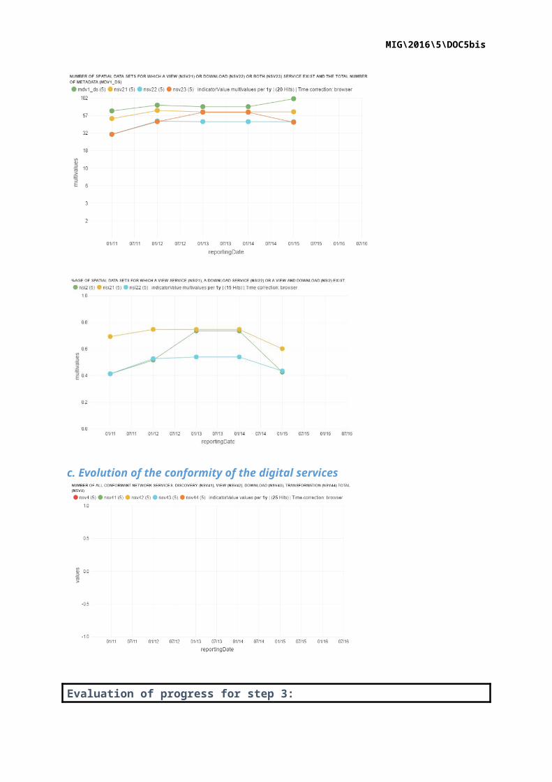
2.3. Accessibility of the data through digital services (step 3)
a. Digitally accessible spatial data per INSPIRE theme in 2015Note: This figure reflects the amount of spatial data sets made available through a digital service, not the amount of available digital services. A digital service can make several spatial data sets available.
b. Evolution of spatial data made accessible through digital services

MIG\2016\5\DOC5bis
c. Evolution of the conformity of the digital services
Evaluation of progress for step 3:Country has:- 60,2% of its data sets accessible for viewing through a view service;- 43,5% of its data sets accessible for download through a download service.None of the available digital services are conform to the INSPIRE network service specifications (0%). Country shows that it has built the necessary capacity and competences to make data accessible through digital INSPIRE network services. The offering is stagnating and a significant amount of the spatial data still has to be brought online. The technical conformity of the available services with the INSPIRE network service specifications is poor. Country should boost their effort to further improve the accessibility of their spatial data through digital INSPIRE services.
MIG\2016\5\DOC5bis
2.4. Interoperability of spatial data sets (step 4)The interoperability of spatial data sets is an outlook on the readiness of Member States to make their spatial data interoperable according to the interoperability specifications laid down in the INSPIRE interoperability implementing regulation (Commission Regulation (EU) No 1089/2010). The deadlines for implementation of the spatial data interoperability are in the future: 23/11/2017 for Annex I data and 21/10/2020 for Annex II and III data.
a. Evolution of the conformity with INSPIRE interoperability specifications for spatial data
Evaluation of progress for step 4:Country has not reported any data set to be conform to the INSPIRE interoperability specifications in 2015. With a reported dataset conformity of 0% across the INSPIRE annexes for 2015, we can conclude that Country has not yet started its preparations for the 2017/2020 data interoperability deadlines. None of the reported datasets are reported to be conform to the INSPIRE interoperability requirements.
3. OutlookCountry has critically reviewed their INSPIRE implementation and provided an action plan in 2016 to remediate existing implementation issues and further improve the overall conformity of the implementation. The following actions are set up to directly address previously identified issues:
a. Coordination (1.1; 1.2) Strengthening cooperation (Regular task for the period 2016-2020): strengthening the
cooperation and connection od individual. Furthermore, the following continuous tasks have been defined to guarantee maintenance,
capacity building and further development of the INSPIRE infrastructure:o Realization of NCP obligation (monitoring report, data management, geoportal
maintenance …).

MIG\2016\5\DOC5bis
o Education and awareness raising (training program and awareness raising). o Activities of individual subgroups of the INSPIRE project group (metadata,
standardization, open data, data quality, service quality).
b. Data sharing and exchange (1.4) The following continuous tasks have been defined to install a data policy for spatial datasets
aligned with INSPIRE implementation rules:o Ensuring data sharing and reuse: agreements on data sharing; monitoring of actual
response times.o Coordination of data sharing and data exchange: connecting activities with tasks
of eGovernment and the ISA2 program (Re3gistry, Are3na, EULF, GeoDCAT); open data initiative.
o Educating and training: regular informing and training on unifying data policy for spatial data; updating recommendations and best practices regarding data access policy and data reuse policy.
c. Metadata (2.2) Metadata for the national spatial data infrastructure (NSDI) (Regular task): ensuring
complete compliance of metadata descriptions for all datasets from the list (view network service) as stated in the INSPIRE Directive and Commission regulation for metadata; creation of metadata for new datasets and network services.
Maintaining the metadata system of the geoportal (Regular task): software upgrade for the metadata system.
d. Network services (2.3) Working and accessible network services compliant with the implementation rules for
all new and substantively renewed spatial data (by 10 December 2016): production of a compliant view network service for spatial dataset – WMS for new and substantively renewed spatial data; production of a download network service for spatial data (ensuring data in and INSPIRE compliant scheme) – WFS for new and substantively renewed spatial data.
View, download and transformation network services for all datasets from the spatial data themes corresponding with the themes of Annex I and compliant with the implementation rules for interoperability (by 23 December 2017): establishment of missing network services compliant with the implementation rules for interoperability for all datasets from the spatial data themes corresponding with the themes of Annex I; implementation of the Commission Regulation (EU) No 1089/2010 of 23 November 2010 implementing Directive 2007/2/EC of the European Parliament and of the Council as regards interoperability of spatial data services for the remaining spatial datasets from Annex I which are still being used in the timeframe of the bill passing.
Network services for all datasets from the spatial data themes (Annex II and Annex III) compliant with the implementation rules for interoperability (by 21 October 2020): establishment of all network services; for all datasets from the spatial data themes (Annex II and Annex III) compliant with the implementation rules for interoperability; enabling access to the other spatial datasets from Annex II and III in compliant with the implementation rules for Annex II and Annex III.
e. Data Interoperability (2.4) Harmonization of spatial datasets to ensure interoperability (by 10 December 2020):
establishment of a code list register and unique identifiers for defining and classifying spatial objects published in geoportal; forming of rules for geo-referencing and interrelations between spatial objects; establishment of a common system of identifiers for spatial objects and defining of key attributes; forming connections to multilingual glossaries; unified way for data exchange of the time dimension of spatial datasets and a defined way for exchange automatically maintained (changed) dataset content.

MIG\2016\5\DOC5bis
4. Summary - How is Country doing?
INSPIRE key obligation
Overall implementation status and trend
Outlook Dashboard LegendImplementation Status:
: implementation of this provision is well advanced or (nearly) completed. Outstanding issues are minor and can be addressed easily.
: implementation of this provision has started and made some progress but is still far from being complete. Outstanding issues are significant and need to be addressed to ensure that the objectives of the legislation can still be reached by 2020.
: implementation of this provision is falling significantly behind or has not even started. Serious efforts are necessary to close implementation gap.
Trend:
: the trend of the implementation is positive.
: the trend of the implementation is neutral.
: the trend of the implementation is negative.
Outlook:
: clear and targeted actions have been identified which allow reaching the objectives of the legislation in an effective way.
: No real progress has been made in the recent past or actions which have been identified are not clear and targeted enough to predict a more positive outlook.
: no actions have been identified to overcome identified implementation gaps.
Ensure effective coordination
Data sharing without obstacles
Step 1: Identify spatial datasets
Step 2: Document datasets (metadata)
Step 3: Provide services for identified spatial datasets (discovery, view, download)
Step 4: Make spatial datasets interoperable by aligning them with the common data models.

MIG\2016\5\DOC5bis
Specific recommendations: Country has made good progress on the implementation of the essential components provisioned by the INSPIRE Directive but has made little improvement on the technical conformity of the implementation. In order to be able to:
fully contribute to the European Spatial Data Infrastructure (SDI); render the NSDI more effective in view of support for EU environmental
legislation and better reusable in the context of cross-border and cross-domain applications;
the NSDI should be further improved by:
critically reviewing the effectiveness of its data policies and amend them, taking 'best practices' into consideration;
identifying and documenting spatial data sets required under the existing reporting and monitoring regulations of EU environmental law, and make these data sets and documentation at least accessible 'as is' to other public authorities and the public through the digital services foreseen in the INSPIRE Directive;
Further improving the conformity of the technical implementation.