introduction of a methodology to mitigate tsunami disaster ... · introduction of a methodology to...
TRANSCRIPT

Introduction of A Methodology to Mitigate Tsunami Disaster by ThePre-evaluation of Tsunami Damage Considering Damage Investigation
of 2004 Tsunami Disaster in the Indian Ocean
1○ KUSAKABE Takaaki2MATSUO Osamu
3KATAOKA Shoujiro
AbstractThe tsunami disaster caused by the Earthquake off the coast of Sumatra, 2004
presented many subjects that we have to consider to mitigate future tsunami disasters.Japan is a high risk country of tsunami disasters historically. Government of Japan ispreparing to mitigate tsunami disasters that will be exactly occurred by huge inter-plateearthquakes such as Tounankai and Nankai Earthquakes. NILIM and PWRI conductedfield investigation of the 2004 Tsunami Disaster in the Indian Ocean. NILIM is nowconducting research to develop pre-evaluation method of Tsunami disaster consideringthe results of the investigation. At the first, the results of the field investigation arepresented in this report. Then a concept of a methodology to mitigate tsunami disaster isintroduced. The methodology is consist of the pre-evaluation of tsunami damage and itsevaluation.
1. Damage Investigation of 2004 Tsunami Disaster in the Indian Ocean1.1. Summary of Investigation
Two of authors participated as members of "The Investigation Delegation ofthe Japanese Government on the Disaster caused by the Major Earthquake off the Coastof Sumatra and Tsunami in the Indian Ocean" The investigation was conducted inThailand and Sri Lanka from March 13 to 21, 2005. Authors investigated damage ofcoastal roads in both countries. Hearing to governmental organization was alsoconducted. Since few traces of damage was observed in Thailand, the damages in SriLanka are reported here.
1.2 Road Damage in Sri Lanka1 Condition of Roads and Bridges in the Damaged Area( )
In Sri Lanka, an arterial road R-A2 was located along the beach and many of its( )
sections were affected by tsunami. As for the arterial road between Colombo andHambantota, the extension of the section which contacts the beach or runs within one ortwo hundred meters from the beach is quite long. Sections which contact the beach areprotected by a rock-mound breakwater. There are fairly long bridges over the rivers that
1 Head, Earthquake Disaster Prevention Division, Reserch Center for Disaster Risk Management, NILIM, MLIT2 Director, Earthquake Disaster Prevention Research Group, PWRI3 Senior Researcher, Earthquake Disaster Prevention Division, RCDRM, NILIM, MLIT

are boundaries of towns or cities. There are many small bridges and causeways oversmall rivers and waterways. With regard to the East coast between Kalmnai andBatticaloa, the distance from the coast to highway was about one kilometer exceptLagoon area. There are sand dunes with a height of 4 to 6 meters along the coast.Behind the sand dunes are lowlands where villages and towns are located. Most of thehouseholds are engaged in fishing.
2 Over view of damages from viewpoint of socio-economical aspect( )
Damages from viewpoint of socio-economical aspect are summerized below:
The amount of damage is LKR 6.3 billion according to JBIC and ADB・
Urgent restoration of the network was completed within two weeks making the・
roads and bridges passable except for the Arugam Bay bridge in the easternprovince.The major damage can be categorized as three types: the erosion of the road・
embankments and the pavements, the collapse of structures, and completely orpartially washed away.In the hearing by the Road Development Authority, the damage to the roads・
resulted in a disruption of traffic and of the supply of necessary goods.According to the hearing at the Galle GA office, there was no serious problem・
caused by road damage, because there were small roads that could be used asdetour routes, even when the arterial roads were not passable.There were still some negative effects such as traffic jams.・
Cars driving along the highway were damaged also.・
3 Typical Examples of Damage of Main road Facilities( )
1 The East Coast)
a Bar Road)
A single span bridge, 8 meters long and 4 meters wide on Bar Road whichruns along the Battocaloa Lagoon and connects with the East Coast Highway, collapsedand fell into the water see Photo-1 . The right-hand side of the photo is the lagoon and( )
the left-hand side is a small inlet. As shown in the photo, the abutments were displacedand parts of the approaching fills were scoured. The mechanism that caused the damageis deduced from our observations: 1 The approaching fills were first scoured by the( )
backflow of tsunami water. 2 The abutments lost their stability due to the scouring of( )
the fills and foundation soils. 3 The abutments displaced outward. 4 The bridge( ) ( )
lost support which caused it to fall into the water. Photo-1 2 was taken from the( )
opposite side of the bridge.
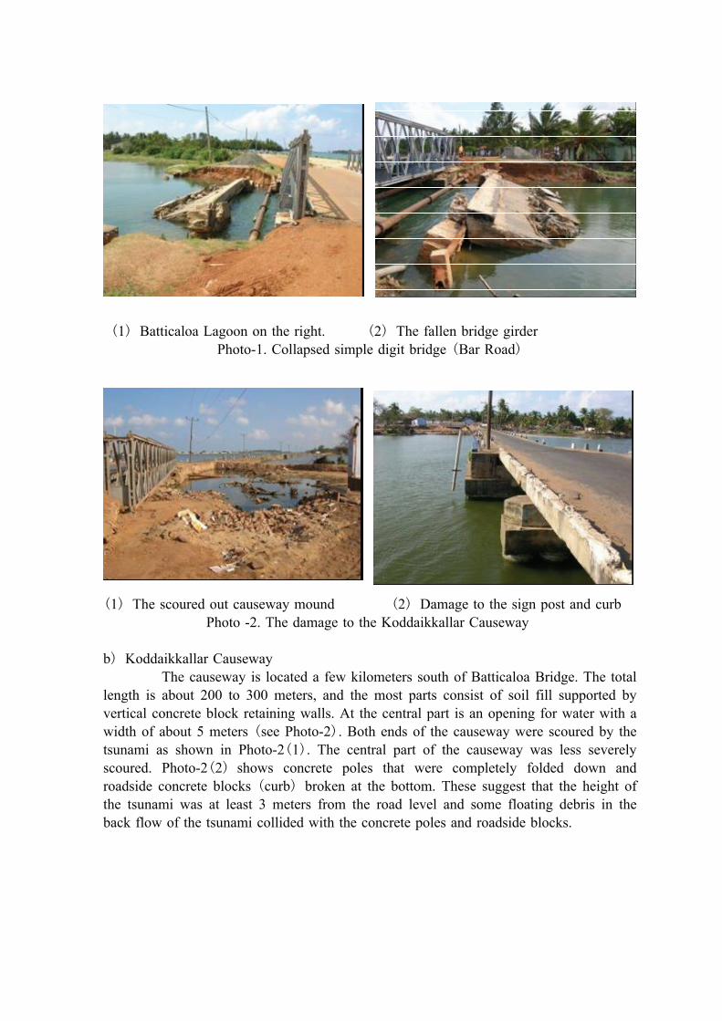
1 Batticaloa Lagoon on the right. 2 The fallen bridge girder( ) ( )
( )Photo-1. Collapsed simple digit bridge Bar Road
1 The scoured out causeway mound 2 Damage to the sign post and curb( ) ( )
Photo -2. The damage to the Koddaikkallar Causeway
b Koddaikkallar Causeway)
The causeway is located a few kilometers south of Batticaloa Bridge. The totallength is about 200 to 300 meters, and the most parts consist of soil fill supported byvertical concrete block retaining walls. At the central part is an opening for water with awidth of about 5 meters see Photo-2 . Both ends of the causeway were scoured by the( )
tsunami as shown in Photo-2 1 . The central part of the causeway was less severely( )
scoured. Photo-2 2 shows concrete poles that were completely folded down and( )
roadside concrete blocks curb broken at the bottom. These suggest that the height of( )
the tsunami was at least 3 meters from the road level and some floating debris in theback flow of the tsunami collided with the concrete poles and roadside blocks.

Photo-3. Periyakallar Causeway Photo-4. A Road in Kalmnai
c Periyakallar Causeway)
This causeway is located a few kilometers south of Koddaikkallar Causeway.There was an opening for water flow at the central part of the causeway. Unlike thedamage to Koddaikkallar Causeway, the sections near the opening were completelyscoured out by the tsunami. In Photo-3 taken from the south looking north, the left-handside is a lagoon and the right-hand side is the sea. The opening had been at the far endof the temporary detour seen on the right that merges the causeway. In the rebuildingwork that was proceeding when we visited, a mixture of concrete debris and sea sandwas used in the lower part of the fill and well-graded soil with gravel was used in theupper part. These are considered to be proper usage of fill materials since the concretedebris from demolished structures was recycled as it was suitable as sub-grade material.
d The Roads in Kalmnai)
As was mentioned, the tsunami washed up over the road in sections within thecity. In the road sections where there were houses alongside, no damage was observed.However, in the embankment road sections with a height of around one meter overmarshlands or paddy fields, damage was observed. It included the erosion of the roadshoulders see Photo-4 and the erosion of embankments at culverts. This damage tends( )
to have occurred at locations where the land was lower than the surrounding area. It ispresumed that the back flow of the tsunami was concentrated on the relatively low lands,causing erosion or the scouring out of embankments and culvert backfills.
4 The South Coast( )
As for the arterial road on the south seashore an investigation was conductedon the section between Colombo and Hambantota. In particular, special attention waspaid to the section between Hikkaduwa and Tangalla Photographs of the damaged sitesare shown below Photos-5 to 12 . The location where the photographs were taken is( )
illustrated in Figure -1.

( ) ( )Photo-5. The Akurala bridge 91Kp Photo-6. Scouring of a bridge 103Kp(① ) (② )in the map in the map
( ③ )Photo-6. Restored bridge near to downtown Galle 91Kp, in the map
Photo-7. Erosion at approach Photo-8. Bridge collapse due to erosion( ④ ) ( ⑤ )near 120Kp, in the map 137Kp in the Map

( ⑥ )Photo-9. Culvert damaged 144Kp in the map
( ⑦ )Photo -10. Damaged causeway with water pipes 145Kp in the map
Photo-11. Undamaged bridge and recovered facilities in the upper stream 166kp, in( ⑧
)the map

(⑨ )Photo-12. A bridge in Hambantota and damage around the bridge in the map
( )Figure-1. Locations of the Photos Taken The South Coast of Sri Lanka
With regard to collapsed bridges, Erosion at the piers were observed. It isconsidered that bridge collapse was caused by erosion of pier, but direct impact of waveforce is not cause of collapse. In addition, generally the damage to the roads was smalleven though damage along the road was serious. For example, in Kahawa where a trainwas washed away, the damage was enormous; however, there were some roads and abridge in the area that went undamaged.

5 Findings of the investigation( )
The results of the investigation of the roads may be summarized as follows:
1 Damage to roads induced by the tsunami included erosion of embankments, erosion)
of abutment backfills, and collapse of bridges following the loss of stability of theabutments.2 Erosion of embankments tended to have occurred at locations where the land was)
relatively low, presumably because the back flow of the tsunami concentrated on thoseparts of the land.3 No bridge girders were washed away by the direct impact force of tsunami.)
4 Damage of people and vehicle on the road is serious problem)
5 Existence of detour and quick restoration weakened the socio-economical impact of)
the damage.
With regard to item 3 , it is too optimistic to conclude that bridges are always)
safe against impact force of the Tsunami. We have to consider there are investigationswhich report that some bridge girders were washed away by the tsunami in Sumatra.
2. Following study being conducted after the investigationThe results of the investigation are suggesting a direction of study to be
conducted for future mitigation of tsunami disaster:1 Investigation shows that road facilities are generally strong against tsunami. To)protect passengers from tsunami is the most important issue.2 Existence of detour and quick restoration weaken the serious damage. We have to)check what will be detour and access route, to plan crisis management and restorationoperation beforehand actually tsunami occurs.3 Though road facilities are generally strong against tsunami, there is risks that bridges)are washed away by tsunami. Collapse of bridges which cross long river influencesemergency operation and socio-economical activity for a long time.
With regard to item 1 and item 2 , it is the most important to divide) )inundated sections by tsunami and passable sections at the time of tsunami disasterbeforehand. To mitigate damage we also have to know relation between damage andimpact or extension of facility damage. With regard to item 3 , it is necessary to)evaluate tsunami force acts on bridges.
NILIM's ongoing study is stepping forward under consideration written above.The study aims to mitigate tsunami disaster by utilizing pre-evaluation of tsunamidamage and consists of three items to develop methodologies written below.
1 Methodology to evaluate risk of bridge washed away)2 Methodology that shows aspects of tsunami damage)3 Methodology to estimate effects of counter measures)

3. Introduction of some results at present3.1 Methodology to evaluate risk of bridge washed away
A series of wave force measurement was conducted by using a wave channelin the NILIM. We consider that bridge girder itself is not broken by wave force. Bridgewill be washed away by the damaged at the support. We measured total drag force andlift force act on girder by a force balance. We have no plan to use pressure distributionthat is measured by pressure tap. Figure-2 shows cross sections of bridge girder tested.and the setting of experiment. Photo-2 shows the process of tsunami attacking bridgegirder. The analysis of measurement has not yet completed. Figure-3 shows an exampleof measured time history of drag force acted on bridge girder. The wave impact forcehas quite steep peak at the moment of attacking. Since bridge girder and peers areelastic, the effective force acts on support of bridge is considered smaller than the peakvalue. Numerical analysis using model shown in Figure-4 is on going to evaluateeffective impact force acts on support of bridges.
Figure-2. A Cross Sections of Bridge Girder and the Setting of Experiment
Figure-3. An Example of Measured Time History of Drag Force
- 5 0
0
5 0
1 0 0
1 5 0
2 0 0
2 5 0
3 0 0
2 7 2 8 2 9 3 0 3 1 3 2 3 3 3 4 3 5
T im e (s e c )
F(k
g)

-0.4sec
-0.2sec
The moment when the maximum wave force was observed
Wter Level: +17.5cm Wave hight: 40cm
Photo-2 Process of Tsunami Attacking Bridge Girder
Figure-4. On going Analysis to Evaluate Effective Impact Force
5 0 c m
Girder
Virtual member
Beam
Pillar
: Panel Point
: Material Particle
26000
1100
250
0530
0
Wave force acts on Material Perticles of the girder
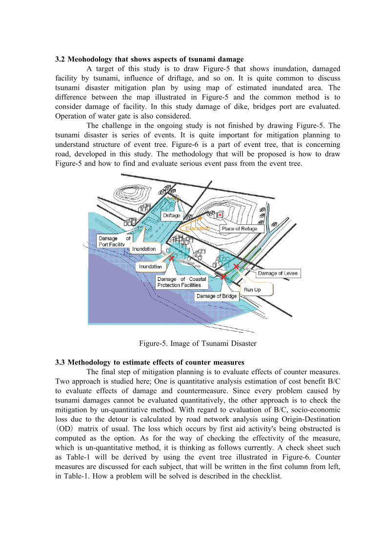
3.2 Meohodology that shows aspects of tsunami damageA target of this study is to draw Figure-5 that shows inundation, damaged
facility by tsunami, influence of driftage, and so on. It is quite common to discusstsunami disaster mitigation plan by using map of estimated inundated area. Thedifference between the map illustrated in Figure-5 and the common method is toconsider damage of facility. In this study damage of dike, bridges port are evaluated.Operation of water gate is also considered.
The challenge in the ongoing study is not finished by drawing Figure-5. Thetsunami disaster is series of events. It is quite important for mitigation planning tounderstand structure of event tree. Figure-6 is a part of event tree, that is concerningroad, developed in this study. The methodology that will be proposed is how to drawFigure-5 and how to find and evaluate serious event pass from the event tree.
Figure-5. Image of Tsunami Disaster
3.3 Methodology to estimate effects of counter measuresThe final step of mitigation planning is to evaluate effects of counter measures.
Two approach is studied here; One is quantitative analysis estimation of cost benefit B/Cto evaluate effects of damage and countermeasure. Since every problem caused bytsunami damages cannot be evaluated quantitatively, the other approach is to check themitigation by un-quantitative method. With regard to evaluation of B/C, socio-economicloss due to the detour is calculated by road network analysis using Origin-DestinationOD matrix of usual. The loss which occurs by first aid activity's being obstructed is( )
computed as the option. As for the way of checking the effectivity of the measure,which is un-quantitative method, it is thinking as follows currently. A check sheet suchas Table-1 will be derived by using the event tree illustrated in Figure-6. Countermeasures are discussed for each subject, that will be written in the first column from left,in Table-1. How a problem will be solved is described in the checklist.

( )Figure-6. A Part of Event Tree An Tentative Image
( )Table-1. Image of the check list for disaster mitigation planning un-quantitative method
4. Concluding RemarksIntroduced in this paper are the results of field investigation of the tsunami
damage in Sri-Lanka, some tentative outputs or output image of on going study. Thestudy by NILIM will be concluded in 2007. Case study will be conducted this year todraw concrete disaster image and event tree. An actual methodology of disastermitigation planning, which was introduced in 3.3 is discussed upon the case study.
Reference
The December 26, 2004 Tsunami Disaster in the Indian Ocean, Report of Investigation,June 2005, The Investigation Derigation of the Japanese Government on the Disastercaused by the Major Earthquake off the Coast of Sumatra and Tsunami in the IndianOcean
Subject Place Scale ofDamage
Risk toHumanlife
Influence toemergencyactivities
Influence tousualActivities
Effects ofcountermeasure
① EmergencyActivities/Deside Detorbeforehand
BigReason:Requirement:
② Human Life/TimelyInformation to gidesafe section
BigReason:Requirement:
Small
Reason:
Trafic jamcaused byunadequateinformationof blockedRoad
City/Adress
Counter measureTarget/Measure
・
・
・
Trafic jam occurred byvihicles enterdimpassable section
Faile to get out in timefrom second attack oftsunami by the trafficjam
Obstacle of emergencyactivity
Widearea
Events
High Risk
Reason:
Big
Reason:
Inland waters overflow
Tsunami strikes
Railways & roads destroyed or damaged
Watercraft damaged, wrecked, or washed out
Timber stored at sea or stacked on land washed
out
Traffic information display boards destroyed
Signal network disabled by inundation
Electric poles collapse
Foul water gets into water supply facilities
Telephone exchange stations destroyed by inundation
Homes, storehouses, and other buildings destroyed by tidal waves and
large drifters
Houses and plowland inundated/contaminated by foul/
muddy water
The rest is omitted
Traffic obstructed by demolished/damaged facilities
Secondary disaster caused by drifting timber, clashing boats, etc.
Traffic obstructed by soil, sand, sediment, and drift
Drainage and sewage canals buried under the debris
Casualties caused by delayed arrival of
ambulance
Fire damage caused by delayed arrival of fire engines
Loss of time, etc, by detour in regular traffic
Traffic 76 Traffic officers
Power outage
Water supply facilities disabled
Facilities’ communications systems
Water trucks
Traffic obstructed by drifters
Loss or devaluation of goods kept in warehouses
Livestock killed by drowning or crushing
Casualties caused by delayed arrival of ambulance
Fire damage caused by delayed arrival of fire engines
Loss of time, etc, by detour in regular traffic
Shelters & temporary housing built
Devaluation of assets and properties
Plowland deserted
Occurrence of earthquake to landfall of tsunami Landfall of tsunami – 24 hours 24 hours – a few days
A few days - Long-term damage