introduction site survey · pdf file6. site survey results at the mouth of the gulf of...
TRANSCRIPT

6. SITE SURVEY RESULTS AT THE MOUTH OF THE GULF OF CALIFORNIA, LEG 65,DEEP SEA DRILLING PROJECT1
B. T. R. Lewis, School of Oceanography, University of Washington, Seattle, WashingtonW. E. Snydsman, Union Oil Corporation, Los Angeles, California
J. S. McClain, University of California, Davis, CaliforniaM. L. Holmes, U.S. Geological Survey, Seattle, Washington
andC. R. B. Lister, School of Oceanography, University of Washington, Seattle, Washington
ABSTRACT
During an IPOD site survey at the mouth of the Gulf of California, an axial valley about 50 km long and 600 metersdeep was found on the East Pacific Rise (EPR) south of the Tamayo Fracture Zone. Magnetic anomalies along the axisof the rise change character from the axial valley to normal sections of the EPR, and off-axis anomalies tend tomeander slightly with age, probably indicating that the axial injection zone wanders slightly with time. Along the BajaCalifornia margin the magnetic lineations cut across the bathymetric expression of the margin, suggesting that theoriginal rifting of Baja from the mainland occurred along a roughly linear zone. A decrease of heat flow and an increasein sediment thickness and water depth with age from 0 to 3.5 m.y. are consistent with concepts of plate tectonics.
Seismic refraction data across and adjacent to the axis of spreading suggest the presence of low-velocity materialunder the axis, possibly the result of a magma chamber, and a crust which thickens rapidly away from the axis.
INTRODUCTION
Site Survey Objectives
The principal objectives of the site survey for the In-ternational Phase of Ocean Drilling (IPOD) in the Gulfof California were to survey and locate sites for (1) adeep drill hole as close to the axis of the East PacificRise (EPR) as possible, and (2) a series of holes crossinga passive continental margin, in this case the margin atthe tip of Baja California.
The first objective was recommended by the JOIDESOcean Crust Panel. In particular, it was desired that ahole be drilled in as young crust as possible so that thechemistry, petrology, magnetic properties, and mecha-nisms of water circulation in the crust could be studiedshortly after its formation. Ridge crests are by defini-tion very young and lack sediment, and yet a technicalrequirement of the site was that there be sufficient sedi-ment (about 100 m) to spud the hole. These competinggoals dictated that the site be close to a source of sedi-ment, which is why the Gulf of California was selected.
The second objective of the site survey was recom-mended by the Passive Margin Panel, which desired todrill holes in both the oceanic and continental crust inorder to look at a young passive margin in terms of thechanges in rock type across the margin and the mecha-nism of rifting that created the margin. The mouth ofthe Gulf of California satisfies these requirements sincethe continental margin at the tip of Baja California wascreated about 3.5 million years (m.y.) ago, when Baja
California was rafted away from mainland Mexico. It isnow a passive margin where no subduction or obductionis occurring. Figure 1 shows the general location of thearea.
28°N -
112°W 110 108 106°
Lewis, B. T. R., Robinson, P., et al., Init. Repts. DSDP, 65: Washington (U.S. Govt.Printing Office).
Figure 1. Location of survey area showing East Pacific Rise andTamayo Fracture Zone.
309

B. T. R. LEWIS ET AL.
For the ridge crest site, the specific objectives were asfollows: (1) to locate and define the rise axis accurately,(2) to locate suitable sediment ponds for drilling, (3) todate the structures found, using magnetic anomalies, (4)to obtain representative core and dredge samples, (5) tomeasure heat flow, and (6) to undertake seismic refrac-tion experiments using ocean-bottom seismometer (OBS)techniques to define the crustal velocity structure forlater comparison with the results of drilling.
For the margin sites, the major objectives were todefine the margin and the location of the initial rupture,and to use seismic refraction methods to investigate anddefine differences between the oceanic crust and con-tinental crust.
Since these potential sites were relatively close together(120 km), it was decided to combine the surveys. Thisappears to have been an advantageous procedure since acoherent picture extending from the ridge to the marginwas obtained.
Previous Studies
Parts of the Gulf of California have been quitethoroughly studied, and a comprehensive compilationof papers on the area was edited by van Andel and Shorand published in 1964 by the American Association ofPetroleum Geologists. These papers covered geophys-ical, geological, paleontological, zoological, and phys-ical oceanographic topics. Subsequently, Normark andCurray (1968) published a detailed description of thegeology and structure of the tip of Baja California, Lar-sen (1972) used magnetic anomaly data to discuss theplate tectonic history of the mouth of the Gulf of Cali-fornia, Molnar (1973) derived fault plane solutions forearthquakes occurring in the Gulf, and Moore (1973)discussed geologic evidence for plate edge deformationin the Gulf of California.
The results we obtained from our detailed site surveyduring 1975 were, however, substantially different fromthose acquired in the course of the earlier studies, a factwhich emphasizes the importance of pre-drilling sitesurveys.
DESCRIPTION OF DATANavigation
The prime instrument for gathering navigation infor-mation was a Magnavox satellite system; normal dead-reckoning procedures were used to establish positionsbetween satellite fixes. Except for a few lines the entiresurvey was run at 6 knots.
During the execution of the seismic refraction lines, amoored telemetering seismic buoy equipped with aradar transponder and reflector was used for detailednavigation. Figure 2 shows the track lines and samplingstations.
Bathymetry and Seismic Reflection Profiling
A Raytheon 12 kHz echo sounder was the primesource of bathymetric data. The depth was recordedevery five minutes, or about every kilometer, and abathymetric contour chart (Fig. 3) was constructed from
these data and any other available data, assuming anaverage water velocity of 1460 m/s.
A Lister electromagnetic attraction transducer wasused for seismic profiling and a 40 in.3 air-gun systemwas used as a backup. The Lister system has its peakoutput at 200 Hz and gives better resolution than theair-gun system but slightly less penetration. Reflectiongear was towed on most lines, including the refractionshooting lines, so that good coverage of the sedimentthickness was obtained and accurate corrections to therefraction data could be made. Selected reflection rec-ords are shown in Figure 4, and a contour chart of sedi-ment thickness in the survey area is shown in Figure 5.
Magnetics
A proton-precession magnetometer was used to mea-sure the total magnetic field strength. No corrections fordiurnal variations or magnetic storms were made, butthe data do not seem to contain any peculiarities thatmight be attributable to such events. The data weresampled once a minute, or about every 200 meters, butwere only digitized to one sample per five minutes sincethe high-frequency variations recorded at the sea sur-face are commonly small. The International Geomag-netic Reference Field over the survey area is essentiallyconstant, so an average value was subtracted from eachline to determine the magnetic anomaly. Figure 6 showsselected magnetic anomaly profiles over the survey area.
Station Operations
A total of 16 stations were occupied during the surveyto collect heat-flow measurements, gravity cores, anddredge haul samples. The locations of the stations areshown in Figure 2. The stations were numbered in con-secutive order, with a two-letter modifier denoting thetype of operation: HF—heat flow, GC—gravity core,DH—dredge haul.
Heat Flow
Nine heat-flow stations were attempted using a Bul-lard-type probe (Lister, 1970). Five of the stations yield-ed usable gradient and conductivity measurements, whileone station gave only gradient information. The loca-tions of these stations are shown in Figure 2 and the re-sults are summarized in Table 1. One heat-flow station(HF-05) was made near Site 482; a second (HF-13) wasmade near Site 483 along Line 6, and four other stationswere made along Line 6 between the rise axis and thecontinental margin (HF-10, 11, 14, and 16).
Cores
Two gravity cores were attempted during the sitesurvey, one at Site 482 and another near the west end ofLine 6. The first core (GC-06), which was located nearone of our OBS stations, penetrated 6 meters and re-turned a sample of gray green mud 1.6 meters long. Thesecond gravity core station (GC-15) showed more than 6meters of penetration but returned with an empty liner.The core weights, however, were covered with a veryfine-grained ooze, suggesting that the sample may havewashed out on the way to the surface.
310

SITE SURVEY RESULTS, LEG 65
23°N -
Gravity CoreDredge HaulHeat-Flow StationReflection TrackReflection and
Refraction Shooting
110W 109= 108°
Figure 2. Survey lines and locations of sampling stations. (Circles show locations of sites drilled on Leg 65.)
23°N
- - ' 2800/ [^2800 ( 2800
t
2T I2OOO -1^Λ { ! /
110°W 109° 108°
Figure 3. Bathymetric chart of survey area. (Data used to compile this chart comes from this study [TT-099, June 1975] and prior work by others.Depths in uncorrected meters. Solid circles show locations of sites drilled on Leg 65.)
311

NW
km
Figure 4. Seismic reflection profiles perpendicular to the rise axis, showing the rise axis, heat-flow values in µcal/cm s, estimated magnetic reversal boundaries and ages (dark stripes repre-sent periods of normal polarity), and our estimate of where the line of initial rifting of Baja is located (speckled zone). The Tamayo Fracture Zone cuts across Line 10 at n shallowangle, and the offset rise crest is seen again on Line 12. The vertical arrow at the margin indicates the position of the 3.4 m.y. isochron.
SITE SURVEY RESULTS, LEG 65
23°N -
11OCW 108
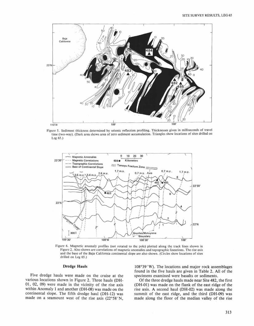
Figure 5. Sediment thickness determined by seismic reflection profiling. Thicknesses given in milliseconds of traveltime (two-way). (Dark area shows area of zero sediment accumulation. Triangles show locations of sites drilled onLeg 65.)
23°30'
23°M
Magnetic Anomalies
Magnetic Correlations
Topographic Correlations
0 10 20 30
484 Kilometersi u ^ v j y i α µ i i i i , UUI iCldUUIIS 77777 T
Base of Continental Slope ^ a m a y o F r acture Zone 22ZZ2ZZ2ZZ3
1.7 m.y. ' 0.7 m.y.
3.4 i0.7 m.y. Axis 1.7 m.y.
109c30' 109°W
22°30'
22°N
108=30' 108°
Figure 6. Magnetic anomaly profiles (not rotated to the pole) plotted along the track lines shown inFigure 2. Also shown are correlations of magnetic anomalies and topographic lineations. The rise axisand the base of the Baja California continental slope are also shown. (Circles show locations of sitesdrilled on Leg 65.)
Dredge Hauls
Five dredge hauls were made on the cruise at thevarious locations shown in Figure 2. Three hauls (DH-01, 02, 09) were made in the vicinity of the rise axiswithin Anomaly 1 and another (DH-08) was made on thecontinental slope. The fifth dredge haul (DH-12) wasmade on a seamount west of the rise axis (22°58'N,
1O8°39'W). The locations and major rock assemblagesfound in the five hauls are given in Table 2. All of thespecimens examined were basalts or sediments.
Of the three dredge hauls made near Site 482, the first(DH-01) was made on the flank of the east ridge of therise axis. A second haul (DH-02) was made along thesummit of the east ridge, and the third (DH-09) wasmade along the floor of the median valley of the rise
313

B. T. R. LEWIS ET AL.
Table 1. Heat-flow stations in the mouth of the Gulf of California.
Station
HF-05HF-10HF-11HF-13HF-14HF-16
Latitude
22°46.8'22°45.5'22°50.6'22°55.5'22°59.5'23°02.7'
Longitude
107°58.5'108°21.0'1O8°35.7'108°42.9'108°59.2'109°04.7'
Gradient(°C/m)
0.6470.3910.3440.2670.1000.267
Conductivity(cal/°C cm s)
1.82 × 10~"3a
1.82 × 10~ 3
1.83 × 1 0 ~ 3
2.01 × 10~ 3
2.31 × 10~ 3
1.98 × 1 0 ~ 3
Heat Flow(µcal/cm2 s)
11.78 ±0 .47.12 ±0 .36.30 ± 0.45.37 ±0 .42.31 ±0.55.29 ± 0.3
BottomWater
Temperature( °Q
1.6701.610b
1.5781.5391.533b
1.643
SedimentThickness
(m)
1676273
125>570
220
WaterDepth
(m)
294829042845300529542508
BasementTemperature
(°C)
110°26°27°35°—60°
Note: Basement temperatures shown were calculated from the sediment thickness and the measured gradient. Errors in the heat-flowvalues are estimated.
a Conductivity assumed." Water temperature was warmer than sediment.
Table 2. Summary of dredge hauls with a brief description of rock assemblages found.
Station Latitude Longitude Samples
DH-01DH-02
22°47'N22°51'N
108c
108cI'W!'W
DH-08 22°9' N 109°8'W
DH-09 22°47'N 108°9'W
DH-12 22°57'N 1O8°39'W
Fresh basalts with glassy margins on pillow surfaces.Basalts with thick glass margins, some devitrification
and palagonite.Basalts, some weathered, some vesicular. Dark, partly
consolidated sediments showing some evidence ofdeformation.
Fresh basalt with glassy margins on pillow surfaces.Some hydrothermally altered sediment?
Basalt with glassy margins, some vesicles. Breccia com-posed of mud and volcanic fragments. Looselyconsolidated sediments.
axis. All three dredge hauls returned fresh to slightlyweathered basalts, many with glassy margins up to one-half cm thick. The hauls in the median valley and on theflank of the east ridge gave very similar samples withfresh glassy pillow structures. The rocks from the sum-mit of the ridge, however, were different. Those rockswere more ropey in nature, with thick (up to 1 cm) glassmargins coated with manganese and showing some de-vitrification and palagonitization.
The dredge haul on the continental margin returnedboth basalt and sedimentary rocks. Some of the basaltsrecovered were quite weathered, while others were freshand vesicular. The sedimentary rocks were composed ofdark silty clay with light interbedded turbidites. Theyranged from loosely to well consolidated and someshowed evidence of deformation.
The dredge haul on the seamount also returned sedi-ments and basalts. The sediments were partially consoli-dated and included a breccia of basalt fragments (somequite glassy) and mud. The basalts were quite fresh withsome glass; several samples contained vesicles.
SeismologyBoth ocean-bottom seismometers and telemetering
buoys were used for refraction studies—the lines shot tothese instruments are shown in Figure 2. In addition tothe explosion sources, numerous earthquakes were re-corded. In fact, one event was sufficiently large to befelt on the ship and required our postponing shootingfor several hours until the area had quieted down. The
details of the experiment were reported by McClain andLewis (1980).
DISCUSSION
MagneticsThe magnetic anomaly profiles taken during the site
survey are shown in Figure 6, together with correlationsbetween anomalies and the ages of the anomalies (fromCox, 1969). Figure 6 also shows the correlation of lineartopographic features in the survey area. From these datawe find an average half-spreading rate of 2.7 cm/y. forthe last 3.5 m.y.
In the rise axis region, the transition from an axialtopographic high to an axial valley is accompanied by adistinct change in the style of the magnetic anomaly. Arather broad axial magnetic low within the centralanomaly on Line 1 south of the valley is replaced by aseries of narrow highs and lows as one proceeds towardthe Tamayo Fracture Zone.
Toward the continental margin of Baja California,there is a well-defined magnetic lineation on 3.5-m.y.-old crust that cuts across the topographic expression ofthe ocean/continent boundary. A careful examinationof the topography in the area shows a small ridge withthe same lineation. To the west of this line, the magneticanomalies die out under continental material. We be-lieve this lineation at 3.5 m.y. marks the rupture linewhere Baja California was rafted away from the main-land. This age and interpretation are similar to that of
314

SITE SURVEY RESULTS, LEG 65
Larsen (1972). It is interesting to note that the ruptureline starts out in oceanic crust on Line 2, cuts across thetip of Baja California on Lines 4 and 6, and extendsaway from the present bathymetrically defined marginon Lines 8 and 10. The rupture line as marked by thetopography seems to extend to Line 10 before being cutoff by the Tamayo Fracture Zone (Fig. 6). As Larsen(1972) has pointed out, prior to 3.5 m.y., the EastPacific Rise was probably truncated by a fracture zoneon the seaward side of Baja California. It is interestingto compare this rupture line with dredge haul results.Normark and Curray (1968) dredged granitic rocks offCabrillo seamount, which is actually part of the con-tinental margin immediately to the west of the ruptureline indicated on Line 2 in Figure 4. Our dredge haulDH-08, which was just north and east of the rupture lineshown on Line 6, returned mostly basalts and sedimen-tary rocks. Thus, the dredge hauls support our inter-pretation of the magnetic data and indicate that onewould expect basaltic basement to the east of the rup-ture line and possibly granitic material to the west.
Another interesting feature of the magnetic data (Fig.6) is that the anomalies do not form straight lines butseem to meander as if the spreading rate changed ir-regularly with time and distance along the ridge. Thisimplies either that the plates are not rigid, which seemsunreasonable, or that the injection zone in the axialregion does not lie on a fixed straight line but migratesin time within some zone or finite width near the axis,giving the apparent asymmetric spreading observed.
To locate reversal boundaries, the magnetic anoma-lies on Profiles 2, 4, 6, 8, 10, and 12 were rotated to thepole using Fourier transform methods (Blakely andCox, 1972) and compared with synthetic anomalies pro-duced by upward continuation of the anomalies associ-ated with a model having positively and negativelymagnetized blocks corresponding to the time scale ofCox (1969). It was found that a constant spreading ratewould not satisfy all of the profiles, so a varying ratewas used to fit individual lines. This of course is prob-ably the manifestation of a meandering spreading centerrather than of varying spreading rates. The reversalboundaries found from this procedure are shown asbars in Figure 4. Inversion of these magnetic anomaliesto obtain the magnetization and a comparison of thismagnetization with that of dredged rocks is discussed byHanley et al. (this volume).
BathymetryProbably the most interesting feature of the area is
the axial valley at the northern end of the rise where itintersects the Tamayo Transform Zone (Fig. 4). Thevalley is up to 1 km deep and 17 km wide. It changes to anormal axial high about 50 km south of the TamayoFracture Zone and is not observed on the offset con-tinuation of the axis north of the fracture zone. Refrac-tion data (McClain and Lewis, 1980) indicate that therift valley may be underlain by thin crust.
Another striking feature of the topography is theremarkable symmetry of structures across the axis. A se-quence of linear sediment ponds, parallel to the rise, can
be clearly correlated across the axis (Lines 4, 6, and 8 inFig. 4). Lewis (1979) has argued that the symmetry inthese data suggest periodicities in the rate of volcanism.
Rift valleys are unusual on the East Pacific Rise, butare observed on slower spreading segments of the ridge.Atwater and Mudie (1968, 1973) describe in detail theblock faulted nature of the axial rift on the Gorda Rise.The Juan de Fuca Ridge has a rift valley or valleys at itsnorthern end where it intersects the Savanco Ridge(McManus et al., 1972). As in the region discussed here,the rift dies out to the south and is not observed north ofthe fracture (Davis and Lister, 1977).
In general, the presence of a rift valley has beenassociated with slow spreading (e.g., Menard, 1967;Sleep and Biehler, 1970). Certainly, the half-spreadingrate in the Gulf of California (2.7 cm/y.) does not con-tradict this relationship (Sleep, personal communica-tion). However, we observe no systematic increase in thespreading rate to the south and yet the rift dies out. Ob-viously another factor must be important. Sleep andBiehler (1970) state that one expects a rift at frac-ture-rise intersections as a consequence of fluid dynam-ic considerations. Contrary to their predictions, we onlyobserve the rift on the southern side of the Tamayo Frac-ture Zone. The spreading rate and the presence of a frac-ture zone are probably important factors in the forma-tion of rift valleys, but the asymmetry observed heresuggests that other unknown factors are also involved.
SedimentsThe sediments which fill the linear valleys generally
increase in thickness away from the axis (Figs. 4 and 5).At Site 482, the P and S wave velocities were low, 1.5and 0.14 km/s, respectively, yielding a true sedimentthickness of about 150 meters (McClain and Lewis,1980). The thickest sediment accumulation is foundalong the continental margin at the base of the continen-tal slope and has a thickness of at least 0.5 s (two-waytravel time).
Heat FlowAs indicated previously, the results of the six heat-
flow stations are shown in Table 1. The values obtainedrange from 11.78 µcal/cm2 s to 2.31 µcal/cm2 s andfollow a trend of decreasing heat flow with age (Lister,1972: Sclater and Francheteau, 1970). The interpreta-tion of these heat-flow results in combination with thedownhole temperatures and thermal conductivities mea-sured on Leg 65 are given by Lewis (this volume).
SeismologyThe results of the seismic refraction studies con-
ducted at the spreading center have been reported indetail by McClain and Lewis (1980), and only the prin-cipal conclusions are presented here. From a line on theeast side of the axis running oblique to the axis a de-tailed crustal velocity profile was obtained. Both travel-time inversion and waveform analysis using syntheticseismograms were used to obtain the velocity profile.These results are shown in Figure 7. The upper crustalvelocity should pertain directly to the drilling results at
315

B. T. R. LEWIS ET AL.
12 -
Velocity (km/s)
Figure 7. Velocity vs. depth profiles applicable to the crust underSites 482 and 485.
Site 482 since the site was within a kilometer or two ofthe OBS sites. The lower crustal velocities probably per-tain to an area older than the drill site since the line wasoblique to the axis. The upper mantle velocity on thisline was found to be 8.0 km/s, which is typical of oldercrustal sites and does not indicate a high temperatureregime.
The results across the rise axis were modeled usingtwo-dimensional ray tracing techniques, and a modelwhich satisfies the travel times is shown in Figure 8 (Mc-Clain and Lewis, 1980). This model has a low-velocityzone in the crust under the axis which could be causedby a zone of partial melting.
CONCLUSIONSThe principal results from this survey were the iden-
tification of an axial valley on the East Pacific Risesouth of the Tamayo Fracture Zone, the mapping ofsediment thickness near the spreading axis, and thedetermination of lithospheric acoustic velocities underand adjacent to the axis. Subsequent to this study, moredetailed bathymetric work in the area was undertakenby MacDonald (1979) using a deep-towed system, andby Rangin (this volume) using the French multibeamsystem. In addition, Fox (personal communication) hasundertaken detailed dredging. The data from these stud-ies will no doubt elucidate in greater detail the geologicprocesses operative in the area.
Figure 8. A. Crustal model across the rise axis obtained by fitting travel times from shots across the axis to atelemetering buoy on the west side of the spreading center (after McClain and Lewis, 1980). Stippled areashows position of low-velocity zone. B. Comparison of computed travel times (dots) and observed traveltimes (dashed and solid lines) for the model in Figure 8A.
316

SITE SURVEY RESULTS, LEG 65
The drilling results on Leg 65 served to confirm theaccuracy of the heat-flow measurements taken duringthe survey (Lewis, this volume) and to clarify the inter-pretation of the seismic velocities in the uppermost crust(Christensen and Lewis, this volume).
Several perplexing questions were identified by thisstudy which remain unanswered, however. Why, for ex-ample, is there an axial valley south of the TamayoFracture Zone but not north of it? While the mechanismof Sleep and Biehler (1970) has considerable merit, itdoes not adequately explain this area, suggesting thatother, unidentified processes are responsible. Why doesthe crust thicken with age? As the Leg 65 drilling hasshown, plate accretion close to a source of sedimentsprovides a specialized geologic environment which givesrise to interlayering of basalt flows and sediments. Thisprovides a relatively impermeable cap to hydrothermalconvection in the crust, which in turn can alter the rateof crustal cooling relative to areas with little sedimentsupply. How does this influence metamorphic processesand crustal aging? In summary, the survey conducted inthe mouth of the Gulf of California was successful inidentifying the drill sites for Leg 65, but it ultimatelyraised as many geologic problems as it solved.
ACKNOWLEDGMENTSThis work was supported by a contract with Columbia University
as a contribution to the International Phase of Ocean Drilling pf theDeep Sea Drilling Project. We thank Dr. Clive Lister for the use of hisheat-flow and acoustic-profiling instruments and Carol Heitman forhis assistance in analyzing the data. We also appreciate the help receivedby students from the Universidad Nacional Autónoma de Mexico andthe captain and crew of the Thomas G. Thompson.
George Sharman of the Scripps institution of Oceanography kindlysent us copies of unpublished reflection profiles from the Davis 1967and 1968 surveys and the 1972 Hypogene survey. These were veryhelpful in planning the cruise and in constructing detailed bathymetricand sediment thickness charts.
REFERENCES
Atwater, T. M., and Mudie, J. D., 1968. Block faulting on the GordaRise. Science. 159:729-731.
, 1973. A detailed near bottom geophysical study of theGorda Rise. /. Geophys. Res., 78:8805-8686.
Blakely, R., and Cox, A., 1972. Identification of short polarity eventsby transforming marine magnetic anomalies to the pole. J. Geo-phys. Res., 77:4339-4349.
Cox, A., 1969. Geomagnetic reversals. Science 163:237-245.Davis, E. E., and Lister, C.R.B., 1977. Tectonic structures on the Juan
de Fuca Ridge. Geol. Soc. Am. Bull., 88:346-363.Larsen, R. L., 1972. Bathymetry, magnetic anomalies, and plate
tectonic history of the mouth of the Gulf of California. Geol. Soc.Am. Bull., 19:521-532.
Lewis, B. T. R., 1979. Periodicities in volcanism and longitudinalmagma flow on the East Pacific Rise at 23°N. Geophys. Res.Lett., 6(10):753-756.
Lister, C. R. B., 1970. Measurement of in situ sediment conductivityby means of a Bullard-type probe. Geophys. J. R. Astron. Soc,19:521-532.
, 1972. On the thermal balance of a mid-ocean ridge.Geophys. J. R. Astron. Soc, 26:515-535.
McClain, J. S., and Lewis, B. T. R., 1980. A seismic experiment at theaxis of the East Pacific Rise. Mar. Geol., 35:147-169.
Macdonald, K. C , Kastens, K., Spiess, F. N., and Miller, S. P., 1979.Deep tow studies of the Tamayo Transform Fault. Mar. Geophys.Res., 4:37-70.
McManus, D. A., Holmes, M. L., Carson, B., and Barr, S. M , 1972.Late Quaternary tectonics, northern end of the Juan de FucaRidge (Northwest Pacific). Mar. Geol., 12:141-164.
Menard, H. W., 1967. Seafloor spreading, topography and the secondlayer. Science, 157:923-924.
Molnar, P., 1973. Fault plane solutions of earthquakes and directionsof motion in the Gulf of California and on the Rivera FractureZone. Geol. Soc. Am. Bull., 84:1651-1658.'
Moore, D. G., 1973. Plate-edge deformation and crustal growth, Gulfof California structural province. Geol. Soc Am. Bull., 84:1883-1906.
Normark, W. R., and Curray, J. R., 1968. Geology and structure ofthe tip of Baja California, Mexico. Geol. Soc. Am. Bull., 79:1589-1600.
Sclater, J. G., and Francheteau, J., 1970. The implications of ter-restrial heat flow observations on current tectonic and geochemicalmodels of the crust and upper mantle of the earth. Geophys. J.,20:509-542.
Sleep, N. H., and Biehler, S., 1970. Topography and tectonics at theintersection of fracture zones with central rifts. /. Geophys. Res.,75:2748-2752.
van Andel, Tj. H., and Shor, G. G. Jr. (Eds.). 1964. Marine Geologyof the Gulf of California: Tulsa (Am. Assn. Petroleum Geologists,Memoir 3).
317