introduction to celebrate the 75th anniversary of...
TRANSCRIPT

INTRODUCTION
To celebrate the 75th Anniversary of Center Line, the information on the following pages isa photo history of the city compiled from a number of sources such as the Detroit andMacomb County histories, family recollections and photos, newspapers and periodicals,yearbooks, and is the culmination of many more sources. It is organized by Settlers & EarlyFamilies and 20th Century Community. The most reliable sources have been used; we hope youenjoy this look back on your local heritage. Happy Anniversary!
SETTLERS & EARLY FAMILIES
These maps show early growth in the yearsimmediately following the addition of Michiganto the Union (1837) as the 26th state. GeraldNeil, Warren civic leader and historian, decidedto publish a small collection of maps toaccompany written accounts of earlydevelopment of the Township. At this time, ithad the name Hickory, a year later Aba, andthen Warren in 1939 . At left, an 1837 view ofthe very earliest settlers to the area such asLouis and William Groesbeck. The horizontalline is Ten Mile Road today and State Roadbecame Sherwood and Mound Road farthernorth.
At right, an 1839 view of Center Line only,as Kunrod’s Corners – later Center Line –began to take shape. Louis Groesbeckmarried a woman from the Beaufait familyin Detroit and they moved to this area.Father‐in‐law Louis Beaufait also purchasedland and assisted in the arduous task ofclearing the dense land and presiding at thefirst Township meetings. Brother Williamfollowed, as did the families of GeorgeCorey, Francois DesGrandchamp, Fabianand Victoire Rivard, George Bolam, and Michael Dalton.
The name of Center Line is taken directly from area Native American tribes. There were threetrails leading north from Detroit that were named by the French: the western trail, known asThe Saginaw Trail, followed what is now Woodward Avenue to the trail’s name and Mackinaw;the eastern, or River Trail, followed today’s Jefferson Avenue to Port Huron; the Centre Line,(note the French spelling), was between these two trails and led from Detroit to Utica. Thename continued and was quickly used in reference to the settlement in the general area of 10Mile and Territorial (or Moravian) Roads. The Moravian missionaries settled to the northeastand used the river and the Territorial Road to access Detroit.

Above left: This etching of William C. Groesbeck’s homestead was included in the appendix toan 1875 atlas map of the Township. Other early families to the area were Bolam,DesGrandchamp, Corey, Miller, Buechel, Busch, Rinke, Weingartz, and Grobbel.
Above right: Alexander Joseph Groesbeck (1873‐1953) served as the 30th Governor of Michiganfrom 1921‐1926. A Republican, he was known as the “road builder” and promoted the use ofconcrete to “take Michigan out of the mud”, sanctioned prison reform, and restructured andconsolidated state government. Father Louis Jr. was Township Clerk and Justice of the Peacebefore becoming Macomb County Sheriff. Grandfather Louis Groesbeck Sr. and uncle William C.were champions for development in this area.
The Postmasters of Michigan list shows that the area had many spellings over the years: CentreLine until 1885, then Center Line until 1893, Centerline until 1906 when the post wasdiscontinued, then in 1923 once again ‐ and finally ‐ Center Line.
Settlers & Early Families, continued
Proceeding with thedifficult task of clearingthe swampy land,heavily wooded withash, elm, birch, andmaple trees.

Settlers & Early Families, continued
Painting by an unknown artist. The first edifice of St. Clement Church, 1854, was built inresponse to the growing need for a Catholic Church. The first muddy tracks were latercovered with wood planks, both were rendered virtually impassable especially in therain. People came from around the Township and beyond to worship here. This is thesame site as the current church. It is hard to imagine that this is a view looking north onwhat is now Van Dyke Avenue!
This is the Mathias and Elizabeth Miller homestead around 1900, on Van Dyke Avenue nearpresent‐day Harding Street. Among those in the picture are Robert Miller, HenryDesGranchamp, Frank Miller, Jim Ines, Mott, and Dick Giff. The Millers operated a saloon, asevidenced by the sign on the porch support for Tivoli, later Altes, Beer in Detroit. The stripedarm attached to another porch support is believed by most preservationists to be theprecursor to the barber’s pole.

Settlers & Early Families, continued
Peter DesGrandchamp and Rosalie Duflot had a neighboring farm to that of William and Louis Groesbeck. All three were located on the southeast quadrant of what was State Road and now Ten Mile.
Here, the family enjoys Christmas Day 1909 at the home of Peter’s son Batholomew and wife Barbara Warner, about a mile west of Peter’s farm. Talented family members made up the band. According to the documentation on the back, they are: Back row (L‐R): Bill Krietmeyer, Louis DesGrandchamp, Fred Qualmann2nd row: Mary DesGrandchamp Shaw, Barbara Warner DesGrandchamp, Mary Shaw DesGrandchamp, Caroline DesGrandchamp Krietmeyer holding Joe, Anne ElwardtDesGrandchamp, Emma Kliest DesGrandchamp holding Lawrence DesGrandchamp, Emma DesGrandchamp Rumph, Frieda Kliest QualmanThe Band: Alfred DesGrandchamp, John DesGrandchamp, Joe DesGrandchamp, Walter DesGrandchamp, William DesGrandchampBottom row: Bartholomew and Edna DesGrandchamp (seated), the children are unidentified.Seated in front at Keg: Ed DesGrandchamp
The second edifice of St. Clement was built in the later 1800s and was visible for miles around. It was demolished in 1960 when the church and school expanded.

Circa 1900. This is John F. Buechel’s store (German pronunciation Beekle), acquired in the late1800s with brother Matt on the developing area of Territorial Road (now Van Dyke) . Theywere busiest on Sundays as people came from miles around for church at neighboring St.Clement Church (second edifice shown at left). John Buechel is in the foreground at right withthe oldest of his children Cecilia at right, and two that may be Anthony and Gertrude. GusMiller stands behind him, and Ben Grobbel next to him. (Identification courtesy of Anna L.Kluck for Echoes of Macomb)
Settlers & Early Families, continued
Inside the GeneralStore on Van Dyke.Son Raymond is atleft, John F. at right,and wife Dorastanding next to him.
The store was laterpurchased and run byAurelius Rivard; herented the upstairsuntil it was purchasedby the church. Thatblock of stores wasdemolished in 1959and with it, one ofCenter Line’s oldestestablishments.

Settlers & Early Families, continuedThe John F. Buechel Family, c. 1910.
John and Dora (Metter) raised 10children: Cecilia (Mrs. Norbert Rinke);Angela and Jeanette, Anthony,Raymond, Gertrude (Mrs. GertrudeHartsig), Sylvester, Irene (Mrs.Raymond Fortin, Eleanor (Mrs. JamesTranchida, and Jon.
Left to right: Wife Dora holdingSylvester; Raymond; John F.; Anthonyand Gertrude. Standing, friend Mrs.Rose De Long, and daughter Cecilia.
In 1863, Joseph and wife Sophia Buechel first bought property and built a store and tavernwith living quarters on the northeast corner of Ten Mile Road and State Road (nowSherwood), presumably the site of the Kunrod establishment. The first post office was atJoseph and Sophia’s place with Hieronymus Engelman serving as the first postmaster in 1878,succeed by Sophia from 1885 – 1897.
John F. was the fourth of 12 children born to Joseph and Sophia. They are: Matthias, Mary,Christianna , John F., Elizabeth (Clara), Helena, Rose, Joseph Jr., George, Anna, Christina,Euphrone.
Jon with members of the Friends of Center Line Library in 1994, at the book signing for a cookbook put out by them.
Jon Buechel was an award‐winning artist and fashion illustrator forthe Detroit Free Press for nearly 40 years beginning around 1949.Born and raised in Center Line, he was the youngest of the tenchildren born to Dora and John F. Buechel. He and wife Shirleyhad three daughters: Claudia (Mrs. Tom Clyne), Melissa, andBridgit (Mrs. Gary Downing), and at the time of this writing, agrandson Paul Thomas and granddaughter Alexandria.

According to a Rinke family history, the farm in Section 17remained in Grobbel family ownership for 100 years until1963, when Raymond (Jim) Grobbel, grandson of JohnGrobbel, sold it and moved to another farm near Richmondin Macomb County. The farmland was then subdividedinto lots for single family dwellings; however, the farmhouse remained standing well into the1980’s. The only remaining evidence of the early properties is a street named “GrobbelDrive” in the subdivision that was carved out of the old farm.
At left, the FranzAnton Grobbelfarmhouse on 11Mile Road, circa1885‐1887. Left toright are his sonBen, wife Elizabeth,Franz Anton,(unknown), and sonAnthony.
Settlers & Early Families, continued
The Wiegand Family is pictured here in the late 1800s in the Village area. Note the sign at left with the family name on it.

Evelyn Marshall and Loyola “Sonny” Rivard, married 1945.
Ruth married Anthony Joseph BuechelRaymond married into the Robbinette
family, and lived on Chicago Rd. & Van Dyke,Frances married into the Trombly family
Joseph Leander Rivard andFrances Baumgartner weremarried on May 14, 1899 inDetroit.They had nine children:Front Row (L‐R): Joseph Jr.,Joseph Sr., Aurelius,Frances, RuthBack Row (L‐R): Cecil,Loyola “Sonny”, Anthony,Leander, Raymond, Frances
Joseph Jr. owned RivardAppliances, Aurelius bought Buechel’s Store renaming it Rivard Grocery, and Anthony owned RivardBros. Ford Sales
Settlers & Early Families, continued
School District No. 2 pictured here around 1900, was the first school building in theCenter Line area of Warren Township. This picture of Plunkett School, complete withprivies to the left, was located at the northeast corner of State (now Sherwood) andTen Mile Roads. The school was so named as Mortimer Plunkett taught alone in thisschoolhouse for many years.
Settlers & Early Families, continued
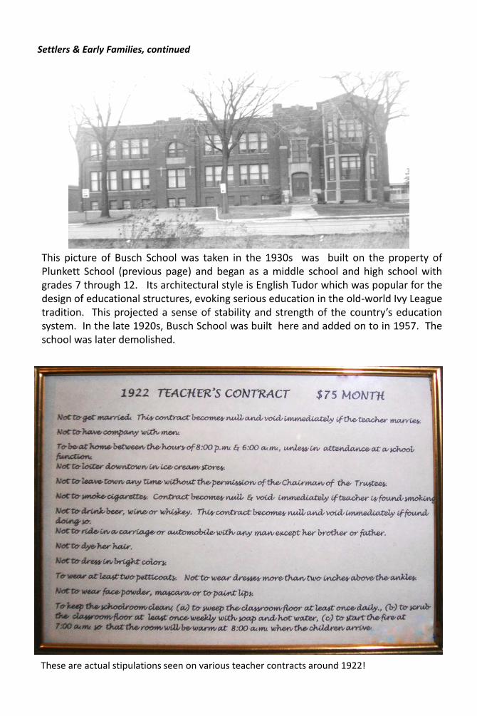
This picture of Busch School was taken in the 1930s was built on the property ofPlunkett School (previous page) and began as a middle school and high school withgrades 7 through 12. Its architectural style is English Tudor which was popular for thedesign of educational structures, evoking serious education in the old‐world Ivy Leaguetradition. This projected a sense of stability and strength of the country’s educationsystem. In the late 1920s, Busch School was built here and added on to in 1957. Theschool was later demolished.
These are actual stipulations seen on various teacher contracts around 1922!