introduction to gis lecture 18: public data 2: other public data sources lecture notes by austin...
Post on 22-Dec-2015
219 views
TRANSCRIPT

Introduction to GIS
Lecture 18:Public Data 2: Other Public Data
Sources
Lecture notes by Austin Troy, University of Vermont © 2006
------Using GIS--

Introduction to GIS
• Comes from both the USGS and the EPA• Surface water features: lakes, ponds,
streams, rivers, springs• Nationally consistent• Order of linkages coded to allow for flow
path analysis• Background info at
http://nhd.usgs.gov/techref.html• Resolutions from 1:100k to 1:24k
National Hydrography Dataset (NHD)

Introduction to GIS
NHD• Many analysis tools designed for this data. For
instance: can find the path upstream or downstream from any point using NHD data and network analyst; flow reaches are numbered sequentially in order of flow to allow path analysis
• Stream reaches encoded like addresses on a street
• Connections encoded using topology• Other tools available at
http://nhd.usgs.gov/tools.html

Introduction to GIS
NHD
• Download at http://nhd.usgs.gov/tools.html

Introduction to GIS
NHD
• Can extract by County/state.
• Click on radio button of geography for clip
• Use check marks to make layers visible in base map
• Then Click on clip boundary (e.g. Chittenden County) in the map viewer

Introduction to GIS
NHD
• Can then choose the resolution and the database type
• Must turn popup blocker off to use
• Then get an email for custom download
Introduction to GIS
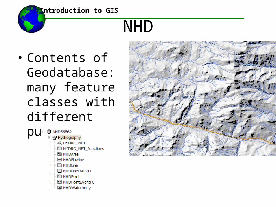
NHD
• Contents of Geodatabase: many feature classes with different purposes

Introduction to GIS
USDA Data
• USDA houses a number of data layers at their new Geospatial data gateway
• http://datagateway.nrcs.usda.gov/

Introduction to GIS
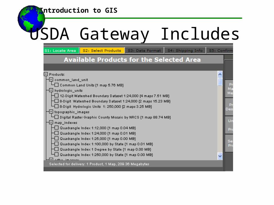
USDA Gateway Includes
• CLU farm boundaries
• Hydrologic Units (8 and 12 digit)
• Digital Raster Graphics
• High resolution color orthophotos from 2003-2004 (National Agriculatural Imagery Program)
• NRCS Soils data and soils tables
• Climate Data (precipitation and temp)
Introduction to GIS
USDA Gateway Includes

Introduction to GIS
USDA Gateway Includes
• Can Define clip regions by state or county
• Can also highlight a layer and get information

Introduction to GIS
Common Land Units
• Farm field boundaries representing smallest contiguous unit of cultivated land
• For farms in USDA programs
• Much more accurate that “agriculture” category in NLCD land cover
• Type of crop is unknown

Introduction to GIS
NAIP
• National Agricultural Imagery Program
• Digital Imagery, mosaiced by county, used by the NRCS and FSA to look at compliance with subsidy programs
• Ortho-rectified,• Color, 1:40,000 scale• 2003 and 2004

Introduction to GIS
SSURGO Soils Data• SSURGO: Soil Survey Geographic
Data from NRCS• Soils data also at
http://soildatamart.nrcs.usda.gov/Default.aspx
• Metadata and standards available at http://soildatamart.nrcs.usda.gov/SSURGOMetadata.aspx
• Entails both a polygon layer showing soils area boundaries, but also an Access Database of numerous soil attributes

Introduction to GIS
National Wetlands Inventory• From Fish and Wildlife Service• Maps all class 1 and 2 major wetlands• Available digitally for much of the country• 1:24,000 or smaller• Involves a complex taxonomy of wetlands
codes available at http://nwi.fws.gov/MapCodesLegend.pdf
• Includes marine, estuarine, riverine, lacustrine and palustrine types

Introduction to GIS
NWI• Wetlands map interface at
http://wetlandsfws.er.usgs.gov/wtlnds/launch.html• Allows you to view online data and download• First shows status availability map:

Introduction to GIS
NWI• Can make PDFs easily
Introduction to GIS
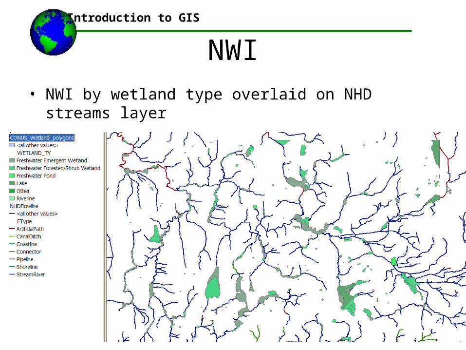
NWI• NWI by wetland type overlaid on NHD streams layer

Introduction to GIS
SSURGO• Soil Data Mart interface
• Access—sample tables; there are dozens

Introduction to GIS
Topologically Integrated Geographic Encoding and Reference System
Automates the mapping and related geographic activities required to support the decennial census and sample survey programs of the census bureau starting with the 1990 decennial census.
The Census TIGER® system supports:Creation and maintenance of the digital geographic data base that includes complete coverage of the United States and its territories
TIGER

Introduction to GIS
The TIGER system provides support for:
• Creation and maintenance of a nation wide digitalgeographic data base
• Production of maps from the TIGER® data base for allCensus Bureau enumeration and publication programs
• Allows for address geocoding
•Can be integrated with Census attribute databases easily

Introduction to GIS
Accuracy and Attribution:
•TIGER has good attribution, but poor accuracy
•They are based partially on 1:100,000 DLG
•Are often conflated
•This is often used to assign the attributes from TIGER® data to 1:24,000 DLG data
Introduction to GIS
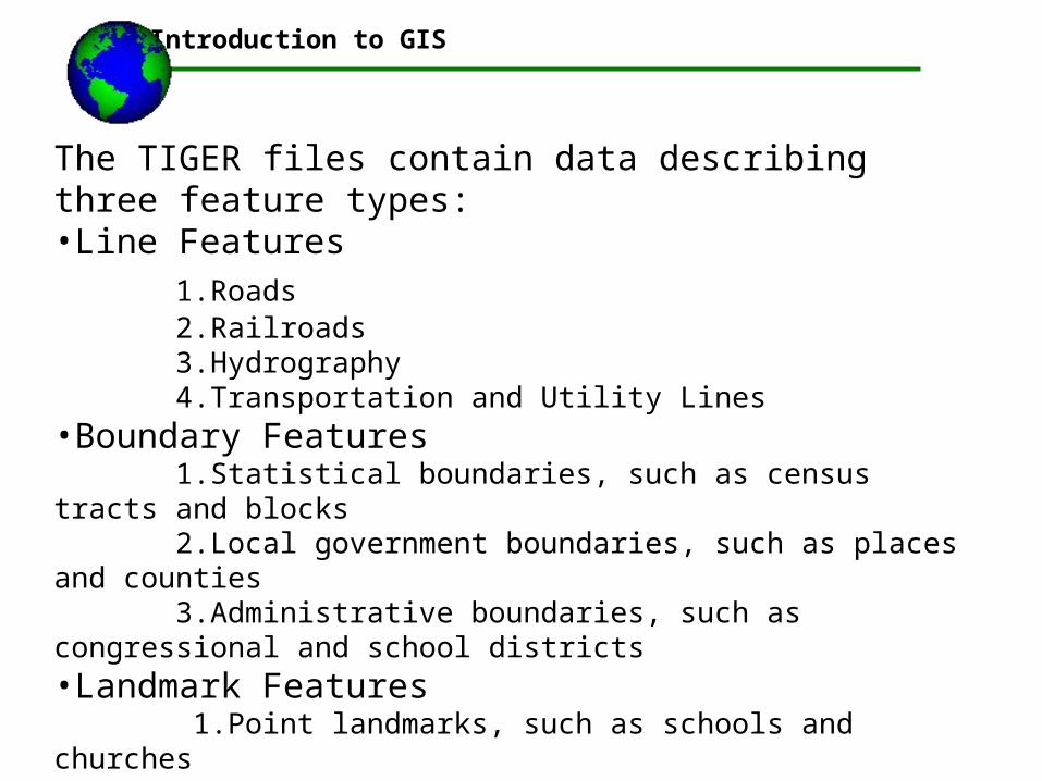
The TIGER files contain data describing three feature types: •Line Features 1.Roads 2.Railroads 3.Hydrography 4.Transportation and Utility Lines•Boundary Features 1.Statistical boundaries, such as census tracts and blocks 2.Local government boundaries, such as places and counties 3.Administrative boundaries, such as congressional and school districts •Landmark Features 1.Point landmarks, such as schools and churches 2.Area landmarks, such as parks and cemeteries 3.Key geographic locations, such as apartment buildings and factories

Introduction to GIS
TIGER line files and the demographic filesDirect linkage using keys built up from:
State FIPS code
County FIPS code
Tract number
Block group number
Block number

Introduction to GIS
Best sources ESRI:http://www.esri.com/data/download/census2000_tigerline/index.html
Download 2000 U.S. Census TIGER lines files and demographic data
Other Sources: UC Davis government data server:http://www.lib.ucdavis.edu/govdoc/MapCollection/tiger.htmlOr UC Berkeley Tiger Server:http://sunsite.Berkeley.EDU/GovData/info/tiger.html

Introduction to GIS

Introduction to GIS

©2006 Austin Troy
Introduction to GISIntroduction to GIS

©2006 Austin Troy
Introduction to GIS
For continuing data updates, check the data links page at http://www.uvm.edu/~nr143/supplement.html
Here you’ll find links to many state level GIS online data repositories plus many of the ones mentioned here
Another link is to map a network drive to \\zoofiles\gisdata
where you’ll find: NAIP imagery, ortho photos, all VCGI data plus VTrans database, World data from ESRI, DRG topo maps, Street maps USA

Introduction to GIS
Other sources for USGS data• www.mapmart.com
– Allows users to choose tiles and layers with a geographic interface
– Most public data are free, but ,any others available for a price
– Gives status maps– Can also buy bulk public data for a fee
• www.gisdatadepot.com– Not as user friendly– Just a plain old interface that is hard to navigate– However, many free data layers and lots of scripts and
extensions

Introduction to GIS
VCGI• The web
site offers many layers through a browser

Introduction to GIS
• Includes an interactive map browser for “clipping and zipping” data