introduction to groundwater sciencefall school on water science, policy and governance laila kasuri,...
TRANSCRIPT

Fall School on Water Science, Policy and Governance
Laila Kasuri, LUMS
Laila Kasuri
LUMS - WIT
Introduction to Groundwater
Science
Fall School on Water Science, Policy and Governance
Laila Kasuri, LUMSLaila Kasuri, LUMS
Overview
• Groundwater Hydrology and Basic
Terms
• Groundwater Movement and Flow
• Groundwater Challenges
• Groundwater Management

Fall School on Water Science, Policy and Governance
Laila Kasuri, LUMSLaila Kasuri, LUMS
What is Groundwater
• Groundwater lies beneath the ground surface,
filling pores in sediments and sedimentary rocks
and fractures in other rock types
• Represents 0.6% of the hydrosphere
• 35x the water in all lakes and rivers combined

Fall School on Water Science, Policy and Governance
Laila Kasuri, LUMSLaila Kasuri, LUMS

Fall School on Water Science, Policy and Governance
Laila Kasuri, LUMSLaila Kasuri, LUMS
Groundwater Basics I• Porosity - the percentage of rock or sediment that
consists of voids or openings
– Measurement of a rock’s ability to hold water
– Loose sand has ~30-50% porosity
– Compacted sandstone may have only 10-20% porosity
• Permeability - the capacity of a rock to transmit
fluid through pores and fractures
– Interconnectedness of pore spaces
– Most sandstones and conglomerates are porous
and permeable
– Granites, schists, unfractured limestones are
impermeable

Fall School on Water Science, Policy and Governance
Laila Kasuri, LUMSLaila Kasuri, LUMS
Groundwater Basics I
• Just because pore space exists doesn't mean that
water can flow through it. Pores may be
isolated.
• Permeability: the ability of a solid to allow
fluids to pass through.

Fall School on Water Science, Policy and Governance
Laila Kasuri, LUMS
•Degree of saturation defines different soil water zones
Groundwater Basics I

Fall School on Water Science, Policy and Governance
Laila Kasuri, LUMS
Saturated Zone: Where all pores are
completely filled with water.
Phreatic Zone: Saturated zone below the water table
Unsaturated Zone: Water in
pendular saturation. Water in
the vadose zone has a pressure
head less than atmospheric
pressure,
Water Table: where fluid
pressure is equal to
atmospheric pressure
Caplillary Fringe: Water is
pulled above the water table by
capilary suction
Groundwater Basics I

Fall School on Water Science, Policy and Governance
Laila Kasuri, LUMSCharbeneau, 2000.

Fall School on Water Science, Policy and Governance
Laila Kasuri, LUMS
•Water table: the surface separating the vadose zone from the saturated zone.
•Measured using water level in wells.
The Water Table
Fig. 11.1

Fall School on Water Science, Policy and Governance
Laila Kasuri, LUMSLaila Kasuri, LUMS
Groundwater Basics II• Subsurface zone in which all rock openings are
filled with water is the phreatic, or saturated
zone. Imagine a soaked up sponge.

Fall School on Water Science, Policy and Governance
Laila Kasuri, LUMSLaila Kasuri, LUMS
Groundwater Basics II• Top of the saturated zone is the water table.
• Saturated zone also called aquifer.
Fall School on Water Science, Policy and Governance
Laila Kasuri, LUMSLaila Kasuri, LUMS
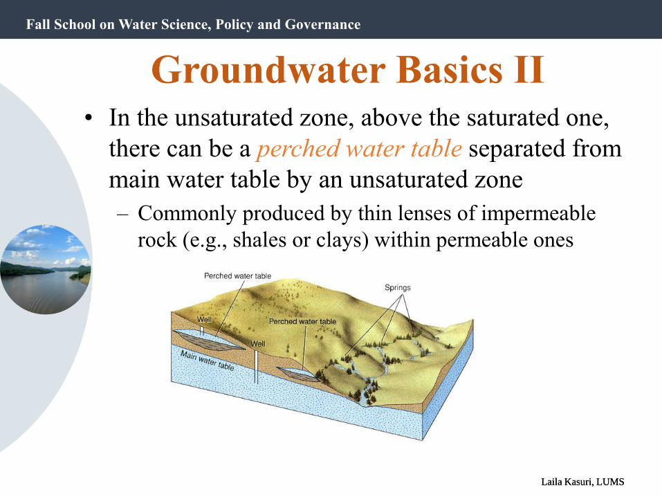
• In the unsaturated zone, above the saturated one,
there can be a perched water table separated from
main water table by an unsaturated zone
– Commonly produced by thin lenses of impermeable
rock (e.g., shales or clays) within permeable ones
Groundwater Basics II

Fall School on Water Science, Policy and Governance
Laila Kasuri, LUMSLaila Kasuri, LUMS
Groundwater Basics I
• Aquifer - body of saturated rock or sediment through
which water can move easily
– Sandstone
– Well-jointed limestone
– Sand and gravel
– Highly fractured
volcanic rock
• Aquitard - rock/sediment that retards ground water flow
due to low porosity and/or permeability
– Shale, clay, unfractured crystalline rocks

Fall School on Water Science, Policy and Governance
Laila Kasuri, LUMSLaila Kasuri, LUMS
Aquifers and Aquitards
• Aquifers can be unconfined or confined by
impermeable rock layers called aquitards.
• In an unconfined aquifer, water flows freely.
The water table tends to approximate the
topography of the landscape.
• In a confined aquifer, water flow is restricted
by impermeable layers called aquicludes.
Aquicludes are a form of aquitards.

Fall School on Water Science, Policy and Governance
Laila Kasuri, LUMSLaila Kasuri, LUMS
Layers that confine
•Aquiclude: formation containing water
do not transmit significant quantities
•Aquifuge: formation
does not contain nor transmit
•Aquitard: formations with low permeability
includes both aquiclude and aquifuge
•Confining bed: rock unit with low hydraulic conductivity
restrict movement of GW either into or out of adjacent aquifers

Fall School on Water Science, Policy and Governance
Laila Kasuri, LUMSLaila Kasuri, LUMS
• Unconfined Aquifer
– Has a water table, and is only partly filled with water
– Rapidly recharged by precipitation infiltrating down to
the saturated zone

Fall School on Water Science, Policy and Governance
Laila Kasuri, LUMSLaila Kasuri, LUMS
• Confined Aquifer
– Completely filled with water under pressure. Separated
from surface by impermeable confining layer/aquitard
– Very slowly recharged

Fall School on Water Science, Policy and Governance
Laila Kasuri, LUMSLaila Kasuri, LUMS

Fall School on Water Science, Policy and Governance
Laila Kasuri, LUMSLaila Kasuri, LUMS
Overview
• Groundwater Hydrology and Basic
Terms
• Groundwater Movement and Flow
• Groundwater Challenges
• Groundwater Management

Fall School on Water Science, Policy and Governance
Laila Kasuri, LUMSLaila Kasuri, LUMS
• Movement of ground water through pores and
fractures is relatively slow compared to flow of
water in surface streams.
Groundwater Movement
Flow time: Hours to years
Flow time: Years to millennia

Fall School on Water Science, Policy and Governance
Laila Kasuri, LUMSLaila Kasuri, LUMS
• Velocity is proportional to
• Permeability
• Slope of the water table
• Inversely Proportional to
• Porosity
• Permeability and Porosity are dependent on
material - Hydraulic conductivity, represented by
K depends on porous media.
Groundwater Movement

Fall School on Water Science, Policy and Governance
Laila Kasuri, LUMS
Darcy’s Law• Henry Darcy established empirically that the energy lost
∆h in water flowing through a permeable formation is proportional to the length of the sediment column ∆L.
• The constant of proportionality K is called the hydraulic conductivity . The Darcy Velocity VD:
VD = – K (∆h/∆L)
and since Q = VD A ( where A = total area)
Q = – KA (dh/dL)

Fall School on Water Science, Policy and Governance
Laila Kasuri, LUMSLaila Kasuri, LUMS
Transmissivity
• Ease with which water moves through an aquifer (rate at which water is transmitted through a unit width of aquifer under a unit hydraulic gradient
T = Kb
T: Transmissivity, units: [L2/T] e.g., m2/d
K: Hydraulic conductivity
b: aquifer thickness
Darcy’s Law with T instead of K

Fall School on Water Science, Policy and Governance
Laila Kasuri, LUMSLaila Kasuri, LUMS
Wells
• A deep hole dug or drilled into the ground to
obtain water from an aquifer
• Wells in unconfined aquifers: Water level before
pumping is the water table
• Wells in confined aquifers: Water may rise to a level
above the top of a confined aquifer, producing an artesian
well
• Water table can be lowered by pumping, a process known
as drawdown

Fall School on Water Science, Policy and Governance
Laila Kasuri, LUMS
•Pumping wells•Accelerates flow near well
•May reverse ground-water flow
•Causes water table drawdown
•Forms a cone of depression
Effects of Pumping Wells

Fall School on Water Science, Policy and Governance
Laila Kasuri, LUMSLaila Kasuri, LUMS
In Pakistan…•Water is supplied through: tubewells, hand pumps, wells, karezes and springs
•No monitoring groundwater network

Fall School on Water Science, Policy and Governance
Laila Kasuri, LUMSLaila Kasuri, LUMS
Overview
• Groundwater Hydrology and Basic
Terms
• Groundwater Movement and Flow
• Groundwater Challenges
• Groundwater Management

Fall School on Water Science, Policy and Governance
Laila Kasuri, LUMSLaila Kasuri, LUMS
Issue 1: Overdraft• Groundwater is replenished mostly by
rain
• If there is less rain than use of the
water, the water level will decrease
• If the water use is stopped, it may
take thousands of years to completely
replenish the groundwater
• If ground water is withdrawn more
rapidly than it is recharged, the water
table will drop
• There could be permanent lowering

Fall School on Water Science, Policy and Governance
Laila Kasuri, LUMSLaila Kasuri, LUMS
• What happens when this well is heavily pumped?

Fall School on Water Science, Policy and Governance
Laila Kasuri, LUMSLaila Kasuri, LUMS

Fall School on Water Science, Policy and Governance
Laila Kasuri, LUMSLaila Kasuri, LUMS
Cone of depression: Area around a well where water table is locally depressed due to withdrawals If cone of depression large enough, can lead neighboring wells to go dry
Issue 1: Overdraft

Fall School on Water Science, Policy and Governance
Laila Kasuri, LUMSLaila Kasuri, LUMS
Issue 2: Subsidence• Ground subsidence (sinking) can occur if water is used
faster than it is replenished
• Dropping water table can lead to ground subsidence
• Creates depressions or sinkholes
• Leads to karst topography (leads to irregular terrain
with various sinkholes)
• Subsidence can crack foundations, roads and pipelines
• Areas of extremely high ground water pumping (such
as for crop irrigation in dry regions) have subsided 7-9
meters

Fall School on Water Science, Policy and Governance
Laila Kasuri, LUMSLaila Kasuri, LUMS
Issue 3: Contamination
Infiltrating water may bring
contaminants down to the water
table, including (but not limited
to):
– Pharmaceuticals
– Pesticides/herbicides
– Fertilizers
– Heavy metals
– Oil and gasoline

Fall School on Water Science, Policy and Governance
Laila Kasuri, LUMSLaila Kasuri, LUMS
Issue 3: Contamination• When groundwater becomes contaminated, it cannot
cleanse itself of degradable wastes as quickly as flowing
surface water does.
• Flows so slowly that contaminants are not diluted and
dispersed effectively.
• Usually colder so chemical reactions are slower.
• It can take decades to thousands of years for contaminated
groundwater to cleanse itself of slowly degradable wastes.
• On a human time scale, nondegradable wastes remain in
the water permanently.

Fall School on Water Science, Policy and Governance
Laila Kasuri, LUMSLaila Kasuri, LUMS
The many sources
of contamination to
groundwater

Fall School on Water Science, Policy and Governance
Laila Kasuri, LUMSLaila Kasuri, LUMS
Issue 3: Contamination• Lahore has a large network of unlined sewerage drains
• Water is leaking from these drains to shallow aquifer
• Salinity of shallow aquifer is increasing
• A large depression cone has developed in the Mozang
area
• As the aquifer is unconfined, shallow saline
groundwater is making its way to the deep aquifer ,
where it is mixing with the deep relatively fresh
groundwater
• As a result, the salinity of deep aquifer is increasing in
the central city area (Mozang, Ichhra, Gawal Mandi,
Assembly Hall)

Fall School on Water Science, Policy and Governance
Laila Kasuri, LUMSLaila Kasuri, LUMS
Point Source and Diffuse Sources
• Point source (localised) eg.
• Leaking tanks
• Spills
• Landfills
• Tar pits
• Diffuse source• Agricultural chemical application (fertilizers / pesticides)
• Large scale mining

Fall School on Water Science, Policy and Governance
Laila Kasuri, LUMSLaila Kasuri, LUMS
Issue 4: Saltwater Intrusion
• In coastal areas, large withdrawal of
fresh groundwater can allow saltwater
to flow into aquifer
• Pumping of groundwater diverts
groundwater from flowing toward sea
seawater movement toward
aquifer
• Causes deterioration of water quality
in coastal aquifers

Fall School on Water Science, Policy and Governance
Laila Kasuri, LUMSLaila Kasuri, LUMS
Locating the Interface
Ghyben-Herzberg relation

Fall School on Water Science, Policy and Governance
Laila Kasuri, LUMSLaila Kasuri, LUMS
Ghyben-Herzberg Relation
The depth to the interface between freshwater and
saltwater is approximately 40 times the height of the water
table above sea level
z h f 40

Fall School on Water Science, Policy and Governance
Laila Kasuri, LUMSLaila Kasuri, LUMS
•Upconing = rise of interface as a result of groundwater pumping

Fall School on Water Science, Policy and Governance
Laila Kasuri, LUMSLaila Kasuri, LUMS

Fall School on Water Science, Policy and Governance
Laila Kasuri, LUMSLaila Kasuri, LUMS
Overview
• Groundwater Hydrology and Basic
Terms
• Groundwater Movement and Flow
• Groundwater Challenges
• Groundwater Management

Fall School on Water Science, Policy and Governance
Laila Kasuri, LUMS
Safe Yield
• “Safe yield”, defined by Conkling and modified by Banks(1953), is an annual extraction rate that does not:
1. Exceed the average annual recharge;
2. Lower the water table so that pumping is uneconomic;
3. Lower gradients so as to admit intrusion of water of undesirable quality;
4. Fail to protect existing water rights.
Replaced by sustainable yield.

Fall School on Water Science, Policy and Governance
Laila Kasuri, LUMSLaila Kasuri, LUMS
Sustainable yield
• Sustainable yield is inherently intergenerational because it implies resource use in ways that are compatible with maintaining them for future generations.
• Proposed National definition (2002):
”The groundwater extraction regime, measured over a specified planning timeframe, that allows acceptable levels of stress and protects the higher value uses that have a dependency on the water.”

Fall School on Water Science, Policy and Governance
Laila Kasuri, LUMSLaila Kasuri, LUMS
Aquifer Sustainability
=> Deep aquifers will likely sustain personal,
but not necessarily irrigation use
Aquifer shallow deep
Residence time 10’s of years 1000’s of years
Recharge rate >>10 cm/year 0.5 cm/year
Personal
consumption
1 cm/year
(Assuming 2640 persons/km2;
10L/person/day)
Irrigation 60 cm/year
Supply
Demand

Fall School on Water Science, Policy and Governance
Laila Kasuri, LUMSLaila Kasuri, LUMS
GW Management
1. Controls on pumping:
• Reducing pumping rates
• Reducing number of pumped wells
2. Artificial recharge through ponds
• Using imported water or reclaimed wastewater
Fall School on Water Science, Policy and Governance
Laila Kasuri, LUMSLaila Kasuri, LUMS
GW Management
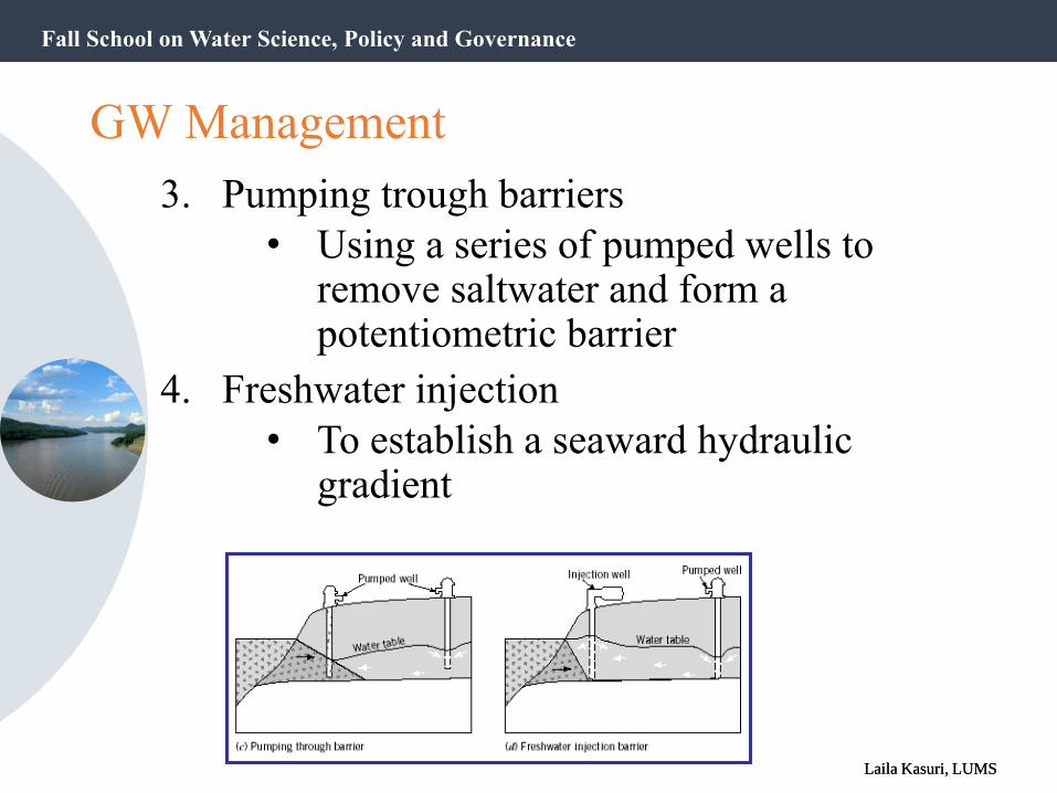
3. Pumping trough barriers
• Using a series of pumped wells to remove saltwater and form a potentiometric barrier
4. Freshwater injection
• To establish a seaward hydraulic gradient

Fall School on Water Science, Policy and Governance
Laila Kasuri, LUMSLaila Kasuri, LUMS
Key management principles…
• Regardless of the key issue for management, the same key elements of the water cycle apply – it is how you use them to achieve your objective that differs.
• Groundwater systems are complex natural systems – the response to your management action is not always what you may expect.
• Efficiency vs infiltration example. Always think of the range of potential outcomes.
• Scale matters – there is a much greater likelihood of interacting with local systems in observable timeframes than with a regional system.

Fall School on Water Science, Policy and Governance
Laila Kasuri, LUMSLaila Kasuri, LUMS
Key management principles…
• Management options can be tested with models.
• A model represents an approximation of a field situation
• Physical models (sand tanks; simulate groundwater flow directly)
• Mathematical models simulate groundwater flow indirectly by means of a governing equation thought to represent the physical processes that occur in the system
• A model is not a replica of reality
• Rather, a structured environment for thinking through a problem

Fall School on Water Science, Policy and Governance
Laila Kasuri, LUMSLaila Kasuri, LUMS
Groundwater Hydrologists are often called upon to predict the behavior of groundwater systems by answering questions like:• What changes can be expected in groundwater
levels in the aquifer beneath Lahore in the year 2020?
• How will a change in stream stage (River Ravi) affect the water table in an adjacent alluvial aquifer?
• What is the capture area for a well field that furnishes municipal water supplies to the city?
• What is the most likely pathway of contaminants if the toxic materials enter the groundwater environment?