introduction to heritage assets: water meadows · meadows and the drowning of peat bogs with an ......
TRANSCRIPT

Water Meadows
On 1st April 2015 the Historic Buildings and Monuments Commission for England changed its common name from English Heritage to Historic England. We are now re-branding all our documents. Although this document refers to English Heritage, it is still the Commission's current advice and guidance and will in due course be re-branded as Historic England.
Please see our website for up to date contact information, and further
advice.
We welcome feedback to help improve this document, which will be periodically revised. Please email comments to [email protected]
We are the government's expert advisory service for England's historic environment. We give constructive advice to local authorities, owners and the public. We champion historic places helping people to understand, value and care for them, now and for the future.
HistoricEngland.org.uk/advice

Introductions toHeritage Assets
Water Meadows
September 2013

Fig 1. Water meadow earthworks on the River Lugg, Herefordshire, picked out by floodwater.
2Water MeadowsIntroductions to Heritage AssetsEnglish Heritage 2
Fig 2. At Prisley Farm, Bedfordshire, William Smith worked for the Duke of Bedford, transforming boggy ground into water meadows.
INTRODUCTIONWater meadows were areas of grassland alongside a river or stream irrigated to produce a rich hay crop and lush grazing. Precisely engineered channels were dug so that a thin sheet of water flowed steadily through the grass sward for set periods of time at prescribed seasons of the year. Their operation, a practice known as ‘floating’ or ‘drowning’, deposited nutrient-laden silt and caused beneficial oxidation of the soil.
In addition, floating in winter reduced the effects of frost and raised the soil temperature, providing an ‘early bite’ of grass for sheep flocks weeks before other pastures were ready. Floating in summer raised moisture levels in the meadows, increasing the hay crop. All this involved skilled management which was often carried out by professionals known as ‘drowners’, ‘meadmen’ or ‘watermen’.
CHRONOLOGYMost pre-17th-century irrigation in England appears to have been by a simple process known as ‘floating upwards’, which involved blocking a watercourse, causing it to overflow and flood the surrounding farmland. This method was used from at least the medieval period and, despite being condemned as ‘ancient’, continued to be used in some areas of England until the 18th century. In the 18th century Dutch engineers introduced a further variety of floating upwards, known as ‘warping’. This practice, used particularly in the Fenlands, involved impounding seasonal tidal water and running it over farmland. Floating upwards deposited beneficial silt and provided some frost protection, but if water failed to drain off quickly it could create anaerobic and toxic conditions which would damage the grass.
To offset problems with water-logging, more sophisticated ‘floating downwards’ systems were developed, which produced a constant movement of water through the grass sward, and enabled strict control of the flow of water on and off the meadows. Two main forms of floating downwards were used: ‘catchworks’ and ‘bedworks’, each suited to different topography.
Catchworks have been found all over Europe. Field names such as ‘Waterleets’, and ‘Le Flodgatemedewe’ recorded during the 13th to 16th centuries suggest they were used in England during the medieval period, and there is a possible 12th-century example at Rievaulx Abbey, Yorkshire. By the early 17th century catchworks were well established in upland parts of south-west England, becoming a particular feature of areas such as Exmoor, and they became more widespread during the later 17th and 18th centuries.
Bedworks, the most sophisticated type of water meadow, appeared fully fledged in the 17th century. They were once believed to have been invented by Rowland Vaughan, a Herefordshire landowner who, in 1610, described irrigation systems which he had created on his farm at Turnastone Court. However, the surviving remains of his irrigation system are quite unlike typical bedworks. Far better evidence comes from Affpuddle, in Dorset, where the manorial court book makes reference in 1605 to ditches and channels, believed to have been bedworks, constructed in the meadows along the River Piddle in that year. From that time, through until around 1900, bedworks were created in large numbers, beginning in the chalk areas of Hampshire, Dorset and Wiltshire, and then spreading during the 17th and 18th centuries to adjacent parts of Gloucestershire, Berkshire, Surrey
and West Sussex. By the 1790s there were an estimated 15,000 to 20,000 acres of water meadow in Wiltshire alone.
The Agricultural Revolution saw English wetlands turned into productive fields and pastures. As agricultural prices rose dramatically during the Napoleonic Wars of 1793-1815, ever-more landowners and farmers invested in catchworks and bedworks, and as the 19th century progressed they became fashionable as an agricultural ‘improvement’. Some landowners offered prizes for their creation and provided raw materials to encourage tenants to construct them. Through the later 18th and 19th centuries their construction was promoted by agricultural improvers such as George Boswell (A Treatise on Watering Meadows 1779), Thomas Wright (An Account of the Advantages of Watering Meadows by Art, 1789), William Smith (Observations on the Utility, Form and Management of Water Meadows and the Drowning of Peat Bogs with an account of Prisley Bog, 1806), James Loch (An Account of the Improvements on the Estates of the Marquis of Stafford, 1820), via papers in the Royal Agricultural Society of England’s Journal and through various county surveys or ‘General Views’ produced for the newly-created Board of Agriculture during the 1790s and early 1800s (Fig 2). By 1850 water meadows in southern England extended to approximately 100,000 acres.
THE DECLINE OF WATER MEADOWSWater meadows fell out of use from the late 19th century onwards, following the onset of deep agricultural recession which continued almost unabated up until the Second World War. The late 19th century saw imports of cheap foreign grain, the introduction of fodder root crops and oil cake, the development of new grass strains and artificial fertilisers. Catchwork meadows became redundant, as hill pastures could be improved by reseeding and nitrogen application. Bedworks
also declined as the sheep and corn farming system broke down in Wessex. In addition to imported grain, improved transport allowed an influx of refrigerated lamb from New Zealand to under-cut British meat prices. By the1930s dairy cattle had replaced sheep on surviving bedwork meadows as the sale of milk, sent to towns by rail, kept many farmers in business. Yet by the mid 20th century falling milk prices and a shortage of labour made the surviving water meadows uneconomical to maintain. The difficulties of mechanisation on the soft surfaces of water meadows, which could not bear the weight of modern machinery, compounded the problems. Almost all water meadows were abandoned and many were destroyed between 1918 and 1960. During the 1950s and 1960s the Ministry of Agriculture, Fisheries and Food offered grants for levelling old water meadows as part of the drive for more efficient food production.
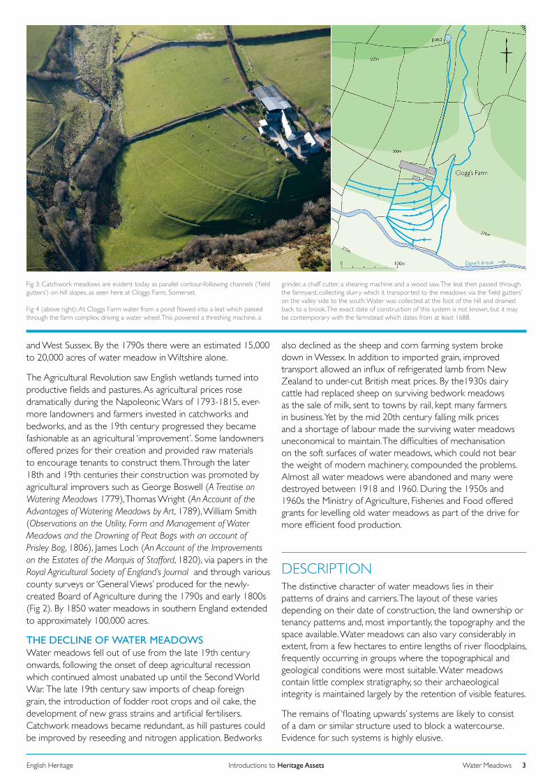
Fig 3: Catchwork meadows are evident today as parallel contour-following channels (‘field gutters’) on hill slopes, as seen here at Cloggs Farm, Somerset.
Fig 4 (above right): At Cloggs Farm water from a pond flowed into a leat which passed through the farm complex, driving a water wheel. This powered a threshing machine, a
Water MeadowsIntroductions to Heritage AssetsEnglish Heritage 3
grinder, a chaff cutter, a shearing machine and a wood saw. The leat then passed through the farmyard, collecting slurry which it transported to the meadows via the ‘field gutters’ on the valley side to the south. Water was collected at the foot of the hill and drained back to a brook. The exact date of construction of this system is not known, but it may be contemporary with the farmstead which dates from at least 1688.
DESCRIPTIONThe distinctive character of water meadows lies in their patterns of drains and carriers. The layout of these varies depending on their date of construction, the land ownership or tenancy patterns and, most importantly, the topography and the space available. Water meadows can also vary considerably in extent, from a few hectares to entire lengths of river floodplains, frequently occurring in groups where the topographical and geological conditions were most suitable. Water meadows contain little complex stratigraphy, so their archaeological integrity is maintained largely by the retention of visible features.
The remains of ‘floating upwards’ systems are likely to consist of a dam or similar structure used to block a watercourse. Evidence for such systems is highly elusive.

Water MeadowsIntroductions to Heritage AssetsEnglish Heritage 4
Fig 5. Reconstruction drawing showing a typical bedwork water meadow.
The simplest form of downward floated water meadow is the catchwork (also known as a ‘catch meadow’ or ‘field gutter’ system). Catchworks used spring water or hill-side streams to irrigate valley or hill slopes. If neither of these water sources was available rainwater and farmyard run-off was collected in a specially-constructed feeder pond. Water was diverted from the source into a contour-following ditch or ‘gutter’ which skirted the top of the meadow. When the gutter was blocked by ‘stops’ of turf, peat or logs, or systems of sluices and boards, water over-flowed down the hillside and irrigated the area of meadow below it. Further down slope further gutters, parallel to the first, caught the water and redistributed it in a similar manner to lower pastures. The process encouraged an even flow of water down the slope. At the base of the meadow the water was collected and carried away via a drain (Figs 3 and 4).
Bedworks were used to irrigate the level ground of river floodplains. A weir or dam containing sluices was placed across the river, often at a bend, allowing water to be diverted into a carrier channel known as a ‘head main’, which was frequently sited on the outside of the bend. A hatch was opened to let water into the head main, from which it flowed into a network of progressively narrower and shallower carrier channels aligned with the gradient of the meadow. Water was admitted to selected areas of the meadow through subsidiary hatches and was held up when necessary by the use of turf ‘stops’. It eventually entered tapering channels known as ‘floats’, situated along the apexes of parallel ridges known as ‘beds’. The water was made to overflow from the floats onto each part of the meadow in succession, running down the sides of the ridges (called ‘panes’) as a continuous moving film no more than 25mm deep. Run-off was removed from the meadow via a network of drains between the ridges. The drains mirror the arrangement of the mains and floats, beginning as small gullies and becoming progressively
larger as they lead to a single ‘tail drain’. In plan bedworks appear as prominent ridges with interlocking channels in the furrow bottoms and, where still visible, along their apexes. The widths and heights of the ridges range from 3-15m (commonly 5m) wide and about 0.5-0.6m high. Bedworks can resemble blocks of ridge-and-furrow ploughing, but their riverine location, their layout and the presence of water control structures all help to distinguish them from former arable (Fig 5).
Very little research has been carried out to establish a typology of water meadows, but field surveys of water meadows can shed light on their regional development. Work in Wiltshire by the Royal Commission on the Historical Monuments of England (RCHME) identified two main bedwork layouts: right-angled (Fig 6) or herringbone (Fig 7). Some systems were also highly geometric with all the ridges straight, while others were irregular with curved ridges. The less regular systems may be considerably earlier than the regular examples.
Built structures are also common features of water meadows. A main weir with hatches was built across a river to divert water into the head main of bedwork systems, while subsidiary weirs and sluices (one-hatch weirs) were set up on the smaller carriers to ensure an even distribution of water. Early hatches were simple boards which slotted vertically into wooden frames or stone settings and were raised by peg and hole arrangements (Fig 9). Later, materials such as brick and cement were used for hatch settings and their boards were fitted with iron ratchet and crowbar raising mechanisms. At the beginning of the 19th century cast iron weirs and hatches came into use. Bridges and culverts were used to provide access across the water meadow channels, and aqueducts sometimes took water to further areas of meadow. Water meadow structures may therefore be made from stone, wood, brick, concrete or metal,

depending on what was readily available at the time of their construction (Fig 10). Collections of loose material near the banks of rivers or streams may indicate the presence of buried structures or the positions of former structures.
Side drain
Main drain
Side carrierMain carrier
0 100Metres
0 100Metres
River Avon
Fig 6. RCHME survey showing a bedwork layout of curved ridges perpendicular to a main carrier at Hindurrington, Wiltshire.
Water MeadowsIntroductions to Heritage AssetsEnglish Heritage 5
Fig 7. A herringbone bedwork layout, using straight ridges, surveyed by the RCHME at Compton, Wiltshire.
DISTRIBUTION AND REGIONAL VARIATIONWater meadows were created anywhere where conditions were suitable and their remains are distributed widely across England. They are more prolific in some areas than others, depending on the local topography and agricultural system, or the presence of large estates once owned by 18th- and 19th-century agricultural improvers.
As catchworks used sloping ground and were relatively cheap to construct and operate without employing professional drowners, they had become popular with hill farmers in Devon, Somerset and the Welsh Marches by the mid-18th century. The improvements catchworks made to hill pastures were dramatic. They transported lime and animal dung to pastures by ‘flush’ irrigation episodes, treating the grass sward with suspended nutrients – a process known as ‘washing in’, whereby dung and lime was mixed into the water. The flow of water also improved the soil through oxygenation and broadleaved grasses flourished at the expense of coarser species. A late form of catchwork, widespread in Britain from the mid-18th century, was sewage irrigation, in which urban sewage was passed along drains to catchwork systems or carted to farms and mixed with head main water.
Catchwork remains are a particular feature of Exmoor, where agricultural improvements promoted by large estates meant
that most farms possessed a system during the 19th century. Farmsteads built by the Knight family for tenant farmers from 1815 onwards were all provided with gutters which passed through farmyards or byres, transporting dung and urine mixed with water onto the meadows.
Bedworks were suitable for level ground on river floodplains, and their remains are found on main rivers, tributaries, minor streams and brooks, sometimes clustering at confluences where most water was available and floodplains were widest. Most are associated with chalkland rivers of southern England which provided a reliable flow of water at a constant temperature and good subsoil drainage. They became an essential component of the ‘sheep and corn’ economy of Wiltshire, Dorset and Hampshire, where they endured for over 400 years. Before their introduction, the size of sheep flocks was limited by the amount of food available to sustain them through the winter, particularly during the ‘hungry gap’ in March and April, when hay supplies were low and grass had not grown. Water meadows promoted grass growth several weeks before natural grazing became available and increased the summer hay crop. Sheep grazed on the meadows during the day and were moved to unsown arable fields to enrich the soil with their dung each evening (Fig 11). This meant that larger sheep flocks could be kept, more manure was produced and arable cultivation could be extended to grow more corn. Although expensive to construct and maintain, bedworks became so profitable that, by the 18th century, they occupied almost every significant floodplain in the region. They commonly doubled the value of meadow land and could increase its value by as much as sixty times its unimproved price.
Both catchworks and bedworks were used in other areas of England with varying degrees of success. They were adapted

Water MeadowsIntroductions to Heritage AssetsEnglish Heritage 6
Fig 8. Haymaking at Byfield (Northamptonshire) around the time of the First World War. The dried hay, lying in windrows, is being loaded onto wagons; one has an almost full load; the next waits to the right. On the left is a horse-drawn hay rake, used to scrape up the scattered remnants of the valuable crop.
Hay and haymakingHay is dried grass, and until artificial feedstuffs and root crops became widely available in the 19th century, it was the principal winter feed for farm animals – without it draught animals and breeding stock could not be kept alive and in good condition through until spring. For livestock farmers, in particular, securing an adequate reserve of good quality hay was the principal summer task.
While hay was made in many fields, generally speaking the best grass for hay was that grown in waterside meadows, especially carefully-managed water meadows. The grass was tall, lush and rich in nutrients. Experienced farmers were able to judge when it was ready to be cut, and when a spell of good, sunny, haymaking weather seemed likely: make hay while the sun shines, as the old proverb has it. Typically this was in later June or July.
It was essential to get the grass cut and dried – turned into hay – as quickly as possible, to reduce its moisture content from about 75 per cent to 15 per cent. The longer it took to dry (for instance if unexpected rain came) the poorer was its quality and nutritional value. Thus – especially until haymaking started to be mechanised in the mid-19th century – as large a labour force as possible would be assembled, often a mixture of the farmer’s family, tenants and hired hands.
Typically these worked from dawn until dusk, kept going with copious amounts of beer or cider.
Working in a line, haymakers moved methodically across the meadow, cutting the lush grass with long-bladed scythes, which would be kept razor-shape with whetstones. This process left the cut grass in lines, and women and children would use pitchforks and rakes to turn and fluff the grass in these ‘windrows’ to speed even drying. Typically this would take a couple of days, and overnight the hay would be raked into heaps – haycocks – to minimise any damage by rain or heavy dew. In the morning the cocks would be opened up, and the turning resumed (Fig 8).
As soon as the hay was dry it was pitched onto haywains – capacious wagons with high sides – and carted to where it was to be stored. Some would immediately be pitched into the lofts of stables or into well-ventilated barns. The rest would be made into hayricks, normally to one side of the farmyard. Like a house, these ricks had pitched tops which, once the hay had settled over a few weeks, were thatched with straw to keep out the weather. Come winter, a large-bladed knife was used to cut blocks of the compressed hay. This was fed to stock, either in the barn or shed or in the field. Sometimes a second cut of hay was taken from water meadows a few weeks after the first, although this grass was probably less nutritious.
to difficult topography, such as the narrow upper valley of the River Wey in Hampshire, where contour-following carrier channels were used to raise water above the river level, aqueducts by-passed bottlenecks in the valley and both the valley sides and the narrow valley floor were irrigated using combinations of catchworks and bedworks. In addition to
the core areas of Wessex and the south-western hills, water meadows have been recorded in many Midland counties, the Welsh Marches and East Anglia. Nineteenth-century commentators unanimously state that water meadows were virtually unknown in northern and eastern England. While it is true that the cold and dry climate, the poor-

draining soils and the gentle gradients of the rivers in eastern England made it less favourable for water meadows, they were adopted sparingly during the 17th and 18th centuries, and in the early 19th century systems managed along Wessex lines were introduced to improve the hay crop.
No comparison between water meadow forms has been carried out at a national level, but regional studies suggest that variation may be seen in earthwork sizes and shapes. The profiles of bedwork ridges vary, from high, rounded, forms recorded in Wessex to broad, flat-topped, forms with sharply-defined edges recorded in Norfolk. This difference may be attributed to variations in local topography and the amount of water available. Early 19th-century farmers in Dorset, for example, complained that very wide ridges were too flat to provide an adequate flow of water across the meadows.
Water MeadowsIntroductions to Heritage AssetsEnglish Heritage 7
Fig 9. A drowner at work on a seven-hatch weir at Lower Farm, Britford, near Salisbury, in 1954.
DATING WATER MEADOWSA detailed complementary approach using documentary records, structural dating and field survey is likely to provide the most information about the date of a water meadow system. Nineteenth-century Ordnance Survey 25” maps, or earlier estate maps, may show the layout of major channels and the positions of sluices at the time the map was made. Historic aerial photographs may also capture water meadows as they existed before destruction in the 20th century. Documents such as estate accounts, water abstraction agreements or records of disputes may provide clues to dates of construction.
Relationships between water meadow remains and other features in the landscape can provide relative dates for a water meadow’s period of use or the time of its abandonment. Examples of this
include meadows at Britford, Wiltshire, and Dilham, Norfolk, which run off the Avon Navigation (constructed 1675-1730) and the Ant Navigation (constructed 1825) respectively, and so the layout visible today cannot pre-date these features. Water meadow systems are also commonly truncated by developments such as railway lines, roads and urban expansion.
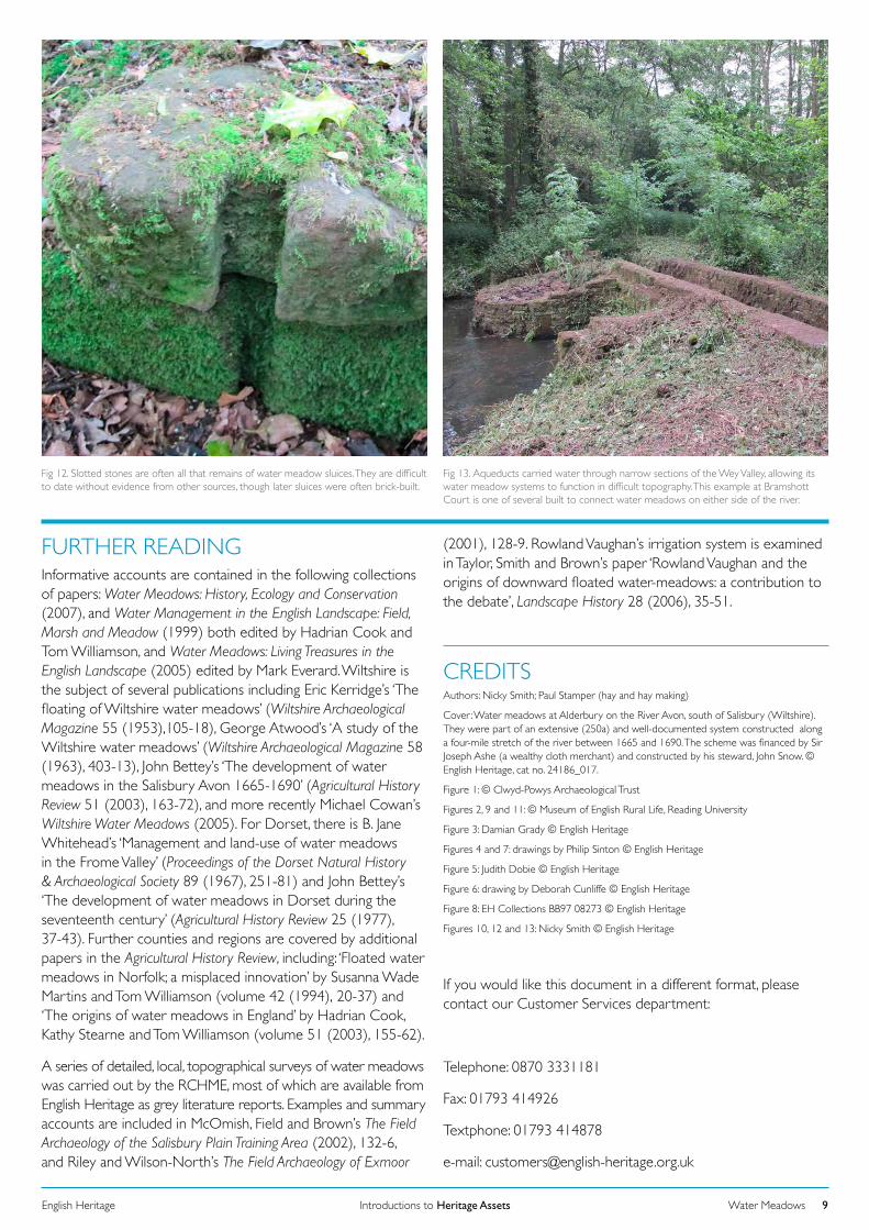
The built structures of water meadows, which will have been regularly maintained during their period of use, provide clues to the dates of the meadows, although some examples may have been constructed several hundred years earlier than their remaining structures indicate. It is possible to estimate the date of bricks by their size, shape or maker’s marks, to recognise 19th-century concrete and to identify sources of stone used. The presence of hatch settings and bridges of rough hewn stone blocks may indicate an early water meadow, constructed before the mid 18th century when brick became freely available (Figs 12 and 13). Later hatches sometimes had iron mechanisms – levers and rack and pinions – derived from water mill technology, to assist in raising and lowering of hatches. In 1811 Hossey and Galpin of Dorchester produced the first cast-iron weirs and hatches, which were far more durable than earlier wooden ones. Many more were produced in local foundries between 1880 and 1910. Sometimes there may be an inscribed date on a built structure, though this is unlikely to date the whole system.
ASSOCIATIONSWater meadows can be spatially or functionally related to a range of contemporary monuments. These include farmsteads, religious houses, stately homes, canals, manor houses, stock enclosures, barns, field systems, landscaped parks, roads, track-ways, settlements, watermills, bridges, fords, ponds and water
cress beds. Many catchworks were ‘integrated systems’, where the main supply of water passed through the farmyard or byre and in the 19th century the idea of using the water supplying the meadows to turn farm machinery developed. Watermills and water meadows often go together because the raised water tables used to drive the mills were also used to float meadows and mill leats served as embryonic water meadow carriers. Occasionally canals served as carriers to supply water meadows. In other instances ponds were created from which water meadow systems were fed. Co-operation between landowners over rights to water was essential for securing a reliable flow of water onto the meadows, so systems were often initiatives of large manors or estates. Many water meadows lay on the home farms of large estates, close to mansions. The popularity of water meadows with agricultural improvers during the late 18th and early 19th centuries and their fashionable nature meant that they were often incorporated into the layout of landscaped parks, as at Woburn, Bedfordshire, where the Duke of Bedford’s meadows were fed from the ‘Temple reservoir’. Capability Brown also created a number of irrigated meadows within the parks he designed, as did other landscape designers. Additionally, water meadows were typically integrated with wider field patterns and drainage systems, which may have dictated, or be reflected in, their layout.
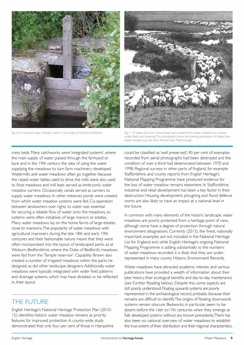
Fig 10. A restored water meadow hatch in use today at Harnham, Wiltshire.
Water MeadowsIntroductions to Heritage AssetsEnglish Heritage 8
Fig 11. In ‘sheep and corn’ areas sheep were moved from water meadows to unsown arable fields each evening. This photograph shows the evening procession of sheep from water meadows by the River Kennet, near Marlborough.
THE FUTUREEnglish Heritage’s National Heritage Protection Plan (2010-15) identifies historic water meadow remains as priority features for improved protection. A county-wide study demonstrated that only four per cent of those in Hampshire
could be classified as ‘well preserved’; 40 per cent of examples recorded from aerial photographs had been destroyed and the condition of over a third had deteriorated between 1970 and 1998. Regional surveys in other parts of England, for example Staffordshire, and county reports from English Heritage’s National Mapping Programme, have produced evidence for the loss of water meadow remains elsewhere. In Staffordshire, industrial and retail development has been a key factor in their destruction. Housing development, ploughing and flood defence works are also likely to have an impact at a national level in the future.
In common with many elements of the historic landscape, water meadows are poorly protected from a heritage point of view, although some have a degree of protection through natural environment designations. Currently (2013), the finest, nationally important, examples are not included in the National Heritage List for England and, while English Heritage’s ongoing National Mapping Programme is adding substantially to the numbers of water meadows recorded, it is likely that they are under-represented in many county Historic Environment Records.
Water meadows have attracted academic interest, and various publications have provided a wealth of information about their later history, their ecological benefits and day-to-day maintenance (see Further Reading below). Despite this, some aspects are still poorly understood. Floating upwards systems are poorly represented in the archaeological record, probably because their remains are difficult to identify. The origins of floating downwards systems remain obscure. Bedworks, in particular, seem to be absent before the 16th to17th centuries when they emerge as fully developed systems without any known precedents. There has also been no national overview of water meadows to establish the true extent of their distribution and their regional characteristics.
Water MeadowsIntroductions to Heritage AssetsEnglish Heritage 9
Fig 12. Slotted stones are often all that remains of water meadow sluices. They are difficult to date without evidence from other sources, though later sluices were often brick-built.
Fig 13. Aqueducts carried water through narrow sections of the Wey Valley, allowing its water meadow systems to function in difficult topography. This example at Bramshott Court is one of several built to connect water meadows on either side of the river.
FURTHER READINGInformative accounts are contained in the following collections of papers: Water Meadows: History, Ecology and Conservation (2007), and Water Management in the English Landscape: Field, Marsh and Meadow (1999) both edited by Hadrian Cook and Tom Williamson, and Water Meadows: Living Treasures in the English Landscape (2005) edited by Mark Everard. Wiltshire is the subject of several publications including Eric Kerridge’s ‘The floating of Wiltshire water meadows’ (Wiltshire Archaeological Magazine 55 (1953),105-18), George Atwood’s ‘A study of the Wiltshire water meadows’ (Wiltshire Archaeological Magazine 58 (1963), 403-13), John Bettey’s ‘The development of water meadows in the Salisbury Avon 1665-1690’ (Agricultural History Review 51 (2003), 163-72), and more recently Michael Cowan’s Wiltshire Water Meadows (2005). For Dorset, there is B. Jane Whitehead’s ‘Management and land-use of water meadows in the Frome Valley’ (Proceedings of the Dorset Natural History & Archaeological Society 89 (1967), 251-81) and John Bettey’s ‘The development of water meadows in Dorset during the seventeenth century’ (Agricultural History Review 25 (1977), 37-43). Further counties and regions are covered by additional papers in the Agricultural History Review, including: ‘Floated water meadows in Norfolk; a misplaced innovation’ by Susanna Wade Martins and Tom Williamson (volume 42 (1994), 20-37) and ‘The origins of water meadows in England’ by Hadrian Cook, Kathy Stearne and Tom Williamson (volume 51 (2003), 155-62).
A series of detailed, local, topographical surveys of water meadows was carried out by the RCHME, most of which are available from English Heritage as grey literature reports. Examples and summary accounts are included in McOmish, Field and Brown’s The Field Archaeology of the Salisbury Plain Training Area (2002), 132-6, and Riley and Wilson-North’s The Field Archaeology of Exmoor
(2001), 128-9. Rowland Vaughan’s irrigation system is examined in Taylor, Smith and Brown’s paper ‘Rowland Vaughan and the origins of downward floated water-meadows: a contribution to the debate’, Landscape History 28 (2006), 35-51.
CREDITSAuthors: Nicky Smith; Paul Stamper (hay and hay making)
Cover: Water meadows at Alderbury on the River Avon, south of Salisbury (Wiltshire). They were part of an extensive (250a) and well-documented system constructed along a four-mile stretch of the river between 1665 and 1690. The scheme was financed by Sir Joseph Ashe (a wealthy cloth merchant) and constructed by his steward, John Snow. © English Heritage, cat no. 24186_017.
Figure 1: © Clwyd-Powys Archaeological Trust
Figures 2, 9 and 11: © Museum of English Rural Life, Reading University
Figure 3: Damian Grady © English Heritage
Figures 4 and 7: drawings by Philip Sinton © English Heritage
Figure 5: Judith Dobie © English Heritage
Figure 6: drawing by Deborah Cunliffe © English Heritage
Figure 8: EH Collections BB97 08273 © English Heritage
Figures 10, 12 and 13: Nicky Smith © English Heritage
If you would like this document in a different format, please contact our Customer Services department:
Telephone: 0870 3331181
Fax: 01793 414926
Textphone: 01793 414878
e-mail: [email protected]