introduction to postgis workshop - universitas...
TRANSCRIPT

W W W . R E F R A C T I O N S . N E T
Introduction to PostGISIntroduction to PostGIS
Paul RamseyPaul Ramsey

W W W . R E F R A C T I O N S . N E T
Spatial Objects for PostgreSQLSpatial Objects for PostgreSQL
• Adds support for geographic objects to the PostgreSQL object-relational database
• PostgreSQL already has “geometric types” but native geometries are too limited for GIS data and analysis

W W W . R E F R A C T I O N S . N E T
PostGIS Overview / HistoryPostGIS Overview / History
• June 2001 –Version 0.1• Spatial types tied to GiST
• July 2001 – Version 0.5• Tie-in to UMN MapServer
• Wider ability to visualize data
• May 2007 – Version 1.2• Full support for OpenGIS SF-SQL
• Performance increases
• Analysis and transformation functions

W W W . R E F R A C T I O N S . N E T
Why PostGIS?Why PostGIS?
• Because databases are better than files• Unified Storage, Management, Access
• SQL Everywhere
• Transactional Integrity• Multiple Users, Multiple Edits

W W W . R E F R A C T I O N S . N E T
WebClient
Internet
uDig
OpenIMF
Mapserver
GeoServer
MapGuide
PostGIS in the Spatial StackPostGIS in the Spatial Stack
LAN
uDig
QGIS
GRASS
ArcGIS
PostGIS

W W W . R E F R A C T I O N S . N E T
Who is using PostGIS?Who is using PostGIS?
- Lots of people …
• 1400 mailing list members • 14K visits/month
10K visitors/month• 100 source code downloads per day
100 windows binary downloads per day• 970K Google search results • Great Google trends …

W W W . R E F R A C T I O N S . N E T
Who is using PostGIS?Who is using PostGIS?
• North Dakota State Water Commission in Bismark uses PostGIS as the cost-effective foundation for managing the use of state-wide water resources. PostGIS tied unobtrusively into their existing desktop systems and pre-empted a costly migration to an ArcIMS/ArcSDE system.

W W W . R E F R A C T I O N S . N E T
Who is using PostGIS?Who is using PostGIS?
• The Ministry of Sustainable Resource Management (British Columbia, Canada) uses PostGIS to store, manage and analyze their Digital Road Atlas, a large and complex road network database.

W W W . R E F R A C T I O N S . N E T
Who is using PostGIS?Who is using PostGIS?
• Institut Géographique National (IGN France) uses PostGIS to underpin a system containing more than 100 million spatial objects, including a 3D national database of roads, rails, hydrography, vegetation, buildings and administrative boundaries.

W W W . R E F R A C T I O N S . N E T
Who is using PostGIS?Who is using PostGIS?
• InfoTerra (United Kingdom) uses PostGIS to store >600 million features of topographic data. Sits at the back-end of their online DataStore. Notable load times of 12 hours for the entire data-suite ~14000 features per second. More notable savings of ~£1000000 per annum.

W W W . R E F R A C T I O N S . N E T
Workshop SummaryWorkshop Summary
• Installation (PostgreSQL and PostGIS)• System Configuration• Creating and Loading Data• Creating Indexes• Query Tuning• Spatial SQL

W W W . R E F R A C T I O N S . N E T
2.1 – PostgreSQL Installation 2.1 – PostgreSQL Installation
• Windows Installer– PostgreSQL 8.2.4– PgAdmin III
• Install as Service to allow automatic database start on boot
• Demonstrate Installation …

W W W . R E F R A C T I O N S . N E T
2.1 – PostgreSQL Installation2.1 – PostgreSQL Installation
W W W . R E F R A C T I O N S . N E T
2.1 – PostgreSQL Installation2.1 – PostgreSQL Installation
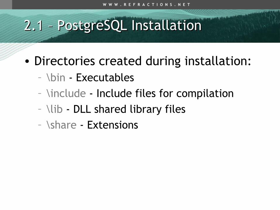
• Directories created during installation:– \bin - Executables – \include - Include files for compilation– \lib - DLL shared library files– \share - Extensions

W W W . R E F R A C T I O N S . N E T
2.1 – PostgreSQL Installation2.1 – PostgreSQL Installation
• Tools included with the install:• PgAdmin III• psql Command Line

W W W . R E F R A C T I O N S . N E T
2.2 – PostGIS Installation2.2 – PostGIS Installation
W W W . R E F R A C T I O N S . N E T
2.2 – PostGIS Installation2.2 – PostGIS Installation
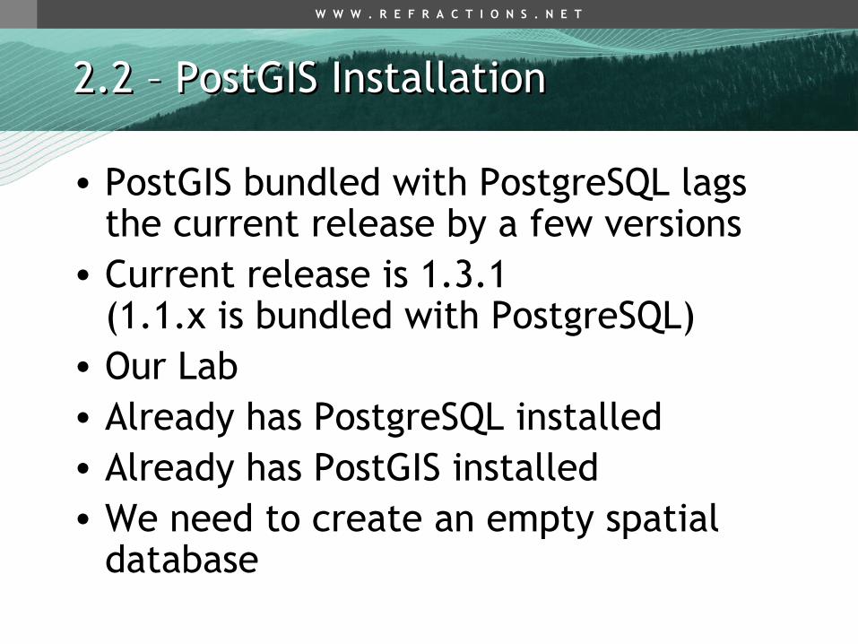
• PostGIS bundled with PostgreSQL lags the current release by a few versions
• Current release is 1.3.1 (1.1.x is bundled with PostgreSQL)
• Our Lab• Already has PostgreSQL installed• Already has PostGIS installed• We need to create an empty spatial
database

W W W . R E F R A C T I O N S . N E T
2.2 – PostGIS Installation2.2 – PostGIS Installation
• A PostgreSQL instance has one software version and one network port (5432)
• An instance contains many databases– Connection string specifies a database
“-h host –U user –d database –p password”
• A database contains many schemas– public
• A schema contains many tables– public.geometry_columns
• A table contains many tuples

W W W . R E F R A C T I O N S . N E T
2.3 – Spatially Enable PostgreSQL2.3 – Spatially Enable PostgreSQL
• Connect to the instance• User “postgres”, password “postgres”
• Create a new database in our local instance• Select “template_postgis” as the template
• Connect to the database• Check for the spatial system tables
• spatial_ref_sys• geometry_columns

W W W . R E F R A C T I O N S . N E T
2.3 – Spatially Enable PostgreSQL2.3 – Spatially Enable PostgreSQL

W W W . R E F R A C T I O N S . N E T
2.3.1 – Without template_postgis 2.3.1 – Without template_postgis
• Create a new database• Select “template1” as the template
• Connect to the database• Load/run the PostGIS extension
(lwpostgis.sql)• Load/run the PostGIS spatial reference
systems (spatial_ref_sys.sql)

W W W . R E F R A C T I O N S . N E T
2.3.1 – Without template_postgis 2.3.1 – Without template_postgis
• Run PG Admin III …

W W W . R E F R A C T I O N S . N E T
2.3.1 – UNIX Installation Note2.3.1 – UNIX Installation Note
PostGIS requires PL/PgSQLcreatelang plpgsql –d postgis –U postgrespsql -f lwpostgis.sql –d postgis –U
postgrespsql -f spatial_ref_sys.sql –d postgis –U
postgres
W W W . R E F R A C T I O N S . N E T
3 Using PostGIS3 Using PostGIS
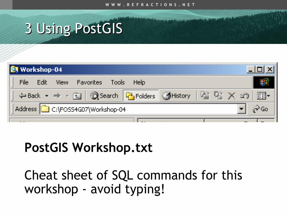
PostGIS Workshop.txt
Cheat sheet of SQL commands for this workshop - avoid typing!
W W W . R E F R A C T I O N S . N E T
3.1 – Simple Spatial SQL3.1 – Simple Spatial SQL
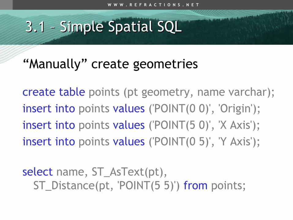
“Manually” create geometries
create table points (pt geometry, name varchar);
insert into points values ('POINT(0 0)', 'Origin');insert into points values ('POINT(5 0)', 'X Axis');insert into points values ('POINT(0 5)', 'Y Axis');
select name, ST_AsText(pt), ST_Distance(pt, 'POINT(5 5)') from points;

W W W . R E F R A C T I O N S . N E T
3.1 – Simple Spatial SQL3.1 – Simple Spatial SQL
• name | astext | distance• --------- + -------------- + ------------------
• Origin | POINT(0 0) | 7.071067• X Axis | POINT(5 0) | 5• Y Axis | POINT(0 5) | 5
• (3 rows)

W W W . R E F R A C T I O N S . N E T
3.2 OGC Metadata Tables3.2 OGC Metadata Tables
• GEOMETRY_COLUMNS– F_TABLE_CATALOG = ‘’– F_TABLE_SCHEMA = ‘public’– F_TABLE_NAME = ‘bc_roads’– F_GEOMETRY_COLUMN = ‘the_geom’– COORD_DIMENSION = 2– SRID = 3005– TYPE = ‘MULTILINESTRING’

W W W . R E F R A C T I O N S . N E T
3.2 OGC Metadata Tables3.2 OGC Metadata Tables
• SPATIAL_REF_SYS– SRID = 3005– AUTH_NAME = ‘EPSG’– AUTH_SRID = 3005– SRTEXT = ‘PROJCS["NAD83 / BC Albers”, … ]’– PROJ4TEXT = ‘+proj=aea …’

W W W . R E F R A C T I O N S . N E T
3.3 – Loading Shape Files3.3 – Loading Shape Files
• Shape File (Misnomer! 3+ Files!)– .shp = geometry– .dbf = attributes (string, number, date)– .shx = utility index
• PostGIS/PostgreSQL Table– Columns can be geometry– Columns can be attributes
• One Shape File = One PostGIS Table
W W W . R E F R A C T I O N S . N E T
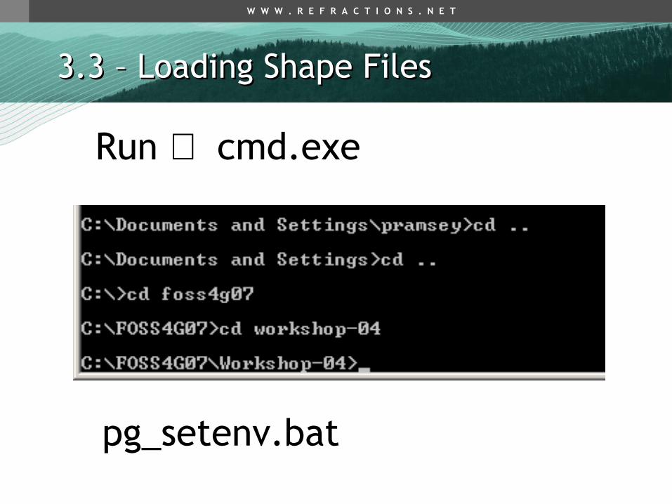
3.3 – Loading Shape Files3.3 – Loading Shape Files
Run ⇒ cmd.exe
pg_setenv.bat

W W W . R E F R A C T I O N S . N E T
3.3 – Loading Shape Files3.3 – Loading Shape Files
• shp2pgsql [opts] shapefile tablename– shp2pgsql –i –s 3005 –D bc_pubs.shp bc_pubs > bc_pubs.sql
• Read in .shp file• Write out .sql file• Load .sql file into PostgreSQL
– using psql – using PgAdmin

W W W . R E F R A C T I O N S . N E T
3.3 – Loading Shape Files – shp2pgsql3.3 – Loading Shape Files – shp2pgsql

W W W . R E F R A C T I O N S . N E T
3.3 – Loading Shape Files3.3 – Loading Shape Files
• shp2pgsql -s 3005 bc_pubs.shp public.bc_pubs > bc_pubs.sql

W W W . R E F R A C T I O N S . N E T
3.3 – Loading Shape Files3.3 – Loading Shape Files
notepad bc_pubs.sql
W W W . R E F R A C T I O N S . N E T
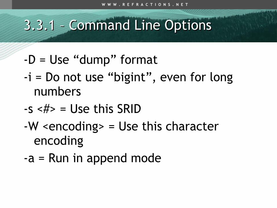
3.3.1 – Command Line Options3.3.1 – Command Line Options
-D = Use “dump” format-i = Do not use “bigint”, even for long
numbers-s <#> = Use this SRID-W <encoding> = Use this character
encoding-a = Run in append mode

W W W . R E F R A C T I O N S . N E T
3.3 – Loading Shape Files3.3 – Loading Shape Files
• pg_shpsql.bat
• shp2pgsql -i -D -s 3005 bc_hospitals.shp bc_hospitals > bc_data.sql
• shp2pgsql -i -D -s 3005 bc_municipality.shp bc_municipality >> bc_data.sql
• shp2pgsql -i -D -s 3005 bc_voting_areas.shp bc_voting_areas >> bc_data.sql
• shp2pgsql -i -D -s 3005 bc_pubs.shp bc_pubs >> bc_data.sql
• shp2pgsql -i -D -s 3005 bc_roads.shp bc_roads >> bc_data.sql

W W W . R E F R A C T I O N S . N E T
3.3 – Loading Shape Files3.3 – Loading Shape Files
•psql –d postgis –U postgres –f bc_data.sql

W W W . R E F R A C T I O N S . N E T
$
$$
$
$$$
$
$
$
$ $
$
$$
$
$
$
$
$
$
$$$
$
$
$
$ $ $$$
$
$
$
$
$$$$$
$
$
$ $$
$
$
$
$$$
$
$
$$$$$$$
$
$
$
$$ $$$$ $$
$
$$$
$
$$
$
$$
$
$
$
$
$
$
$
$
$
$$
$
$$
$
$$$
$$
$
$$$$$
$
$$
$
$
$
$ $
$
$$$
$
$
$$$
$$
$
$$ $$
$
$ $
$
$
$$
$ $$
$
$
$
$
$ $$
$
$
$$
$
$$
$$$$$$$$ $
$
$ $
$
$ $$
$
$
$
$
$$$
$$
$$
$
$
$
$
$
$
$
$
$
$
$
$
$
$
$
$
$
$
$
$$$ $$$
$
$$$
$
$
$
$
$
$
$
$
$
$ $
$
$
$$
$
$
$
$
$
$
$
$
$
$$
$
$$$$ $
$
$$
$
$$
$$$
$
$
$
$$
$
$$ $
$
$
$ $
$
$
$
$
$
$ $
$
$ $
$
$ $$
$
$$
$
$
$
$ $$$
$
$$$$
$
$
$
$
$$
$
$
$
$
$
$
$
$
$$
$
$
$
$$
$$
$
$
$
$$
$$
$ $
$
$
$
$
$
$
$
$
$
$
$
$
$
$$
bc_pubsbc_pubs100s of 100s of pointspoints
W W W . R E F R A C T I O N S . N E T
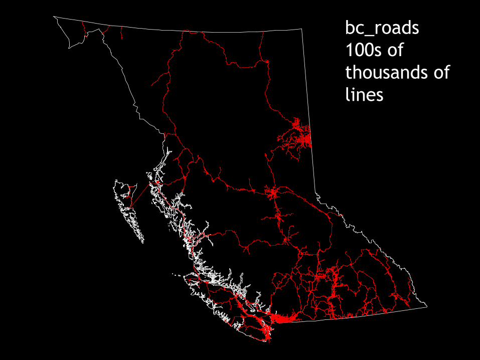
bc_roadsbc_roads100s of 100s of thousands of thousands of lineslines

W W W . R E F R A C T I O N S . N E T
##
#######
#
#
#
#
##
#
#
#
#
#
#
##
#
#######
#
##
#
#
##
##
#
#
#
#
bc_hospitalsbc_hospitals10s of points10s of points

W W W . R E F R A C T I O N S . N E T
bc_municipalitybc_municipality100s of polygons100s of polygons
W W W . R E F R A C T I O N S . N E T
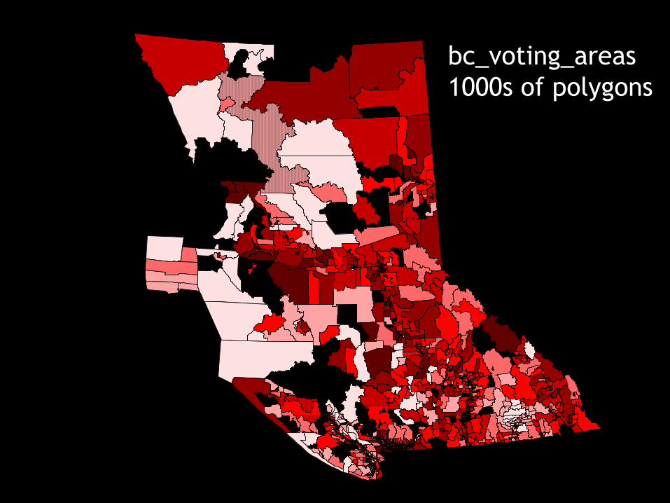
bc_voting_areasbc_voting_areas1000s of polygons1000s of polygons

W W W . R E F R A C T I O N S . N E T
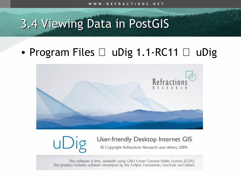
3.4 Viewing Data in PostGIS3.4 Viewing Data in PostGIS
• Quick desktop viewing options– uDig– QGIS– gvSIG– CadCorp SIS*– FME Viewer*
• Web based application options– MapGuide– Mapserver– Geoserver
W W W . R E F R A C T I O N S . N E T
3.4 Viewing Data in PostGIS3.4 Viewing Data in PostGIS
• Program Files ⇒ uDig 1.1-RC11 ⇒ uDig

W W W . R E F R A C T I O N S . N E T
3.4 Viewing Data in PostGIS3.4 Viewing Data in PostGIS
• File ⇒ New ⇒ Layer

W W W . R E F R A C T I O N S . N E T
3.4 Viewing Data in PostGIS3.4 Viewing Data in PostGIS

W W W . R E F R A C T I O N S . N E T
3.4 Viewing Data in PostGIS3.4 Viewing Data in PostGIS

W W W . R E F R A C T I O N S . N E T
3.4 Viewing Data in PostGIS3.4 Viewing Data in PostGIS

W W W . R E F R A C T I O N S . N E T
3.5.1 Creating Spatial Indexes3.5.1 Creating Spatial Indexes
- PostGIS implements R-Tree indexes on top of the GiST indexing system
- Organizes data into nesting rectangles for fast searching
• CREATE INDEX bc_roads_gidx ON bc_roads USING GIST (the_geom);
• (now create indexes on the other tables too…)
W W W . R E F R A C T I O N S . N E T
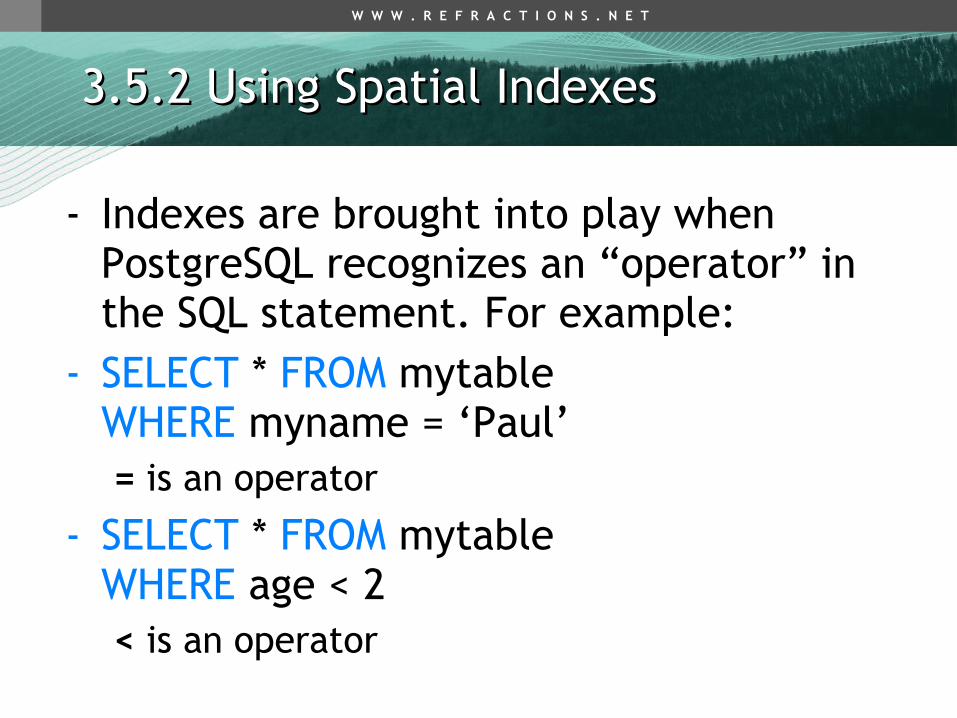
3.5.2 Using Spatial Indexes3.5.2 Using Spatial Indexes
- Indexes are brought into play when PostgreSQL recognizes an “operator” in the SQL statement. For example:
- SELECT * FROM mytable WHERE myname = ‘Paul’= is an operator
- SELECT * FROM mytable WHERE age < 2< is an operator

W W W . R E F R A C T I O N S . N E T
3.5.2 Using Spatial Indexes3.5.2 Using Spatial Indexes
• Spatial index operator is “&&”– “Bounding Boxes Interact”
A && B = TRUEA && B = FALSE

W W W . R E F R A C T I O N S . N E T
3.5.2 Using Spatial Indexes3.5.2 Using Spatial Indexes
• Bounding Boxes are not enough!
• Two pass system required– Use bounding boxes to reduce candidates– Use real topological test to get final answer
A && B = TRUE_ST_Intersects(A && B) = FALSE

W W W . R E F R A C T I O N S . N E T
3.5.2 Using Spatial Indexes3.5.2 Using Spatial Indexes
ST_Intersects(A,B)A && B AND _ST_Intersects(A,B)

W W W . R E F R A C T I O N S . N E T
3.5.2 Using Spatial Indexes3.5.2 Using Spatial Indexes
A && B

W W W . R E F R A C T I O N S . N E T
3.5.2 Using Spatial Indexes3.5.2 Using Spatial Indexes
A && B

W W W . R E F R A C T I O N S . N E T
3.5.2 Using Spatial Indexes3.5.2 Using Spatial Indexes
_ST_Intersects(A,B)

W W W . R E F R A C T I O N S . N E T
3.5.2 - Using Spatial Indexes3.5.2 - Using Spatial Indexes
• Index operations (&&) are built into common functions for automatic use, but you can use them separately if you like.– ST_Intersects(G1,G2)
• G1 && G2 AND _ST_Intersects(G1,G2)
– ST_Contains(G1,G2)– ST_Within(G1,G2)– ST_Touches(G1,G2)– ST_DWithin(G1,G2,D)
• G1 && ST_Expand(G2,D) AND ST_Distance(G1,G2) > D

W W W . R E F R A C T I O N S . N E T
3.5.3 - Spatial Index Test3.5.3 - Spatial Index Test
• Run query with un-indexed function– SELECT gid, name FROM bc_roads
WHERE _ST_Crosses( the_geom, ST_GeomFromText(‘..’, 3005) );
• Run query with indexed function – SELECT gid, name FROM bc_roads
WHERE ST_Crosses( the_geom, ST_GeomFromText(‘..’, 3005) );
• Note speed difference

W W W . R E F R A C T I O N S . N E T
3.5.4 - Indexes and Query Plans3.5.4 - Indexes and Query Plans
• Run queries using the “Explain” button instead of the “Run” button
• Note the graphical display of how the database is using indexes
• Click on the icons to get more information about each step of the query
• Remember to try this later when we start performing more complicated queries

W W W . R E F R A C T I O N S . N E T
3.5.4 - Indexes and Query Plans3.5.4 - Indexes and Query Plans

W W W . R E F R A C T I O N S . N E T
3.5.4 - Indexes and Query Plans3.5.4 - Indexes and Query Plans

W W W . R E F R A C T I O N S . N E T
3.5.5 - When Query Plans go Bad3.5.5 - When Query Plans go Bad
• The database builds “plans” based on statistics about data distribution sampled from the tables– Always tries to be “selective”, to pull the fewest
number of records necessary to move on to the next step
• The database builds bad plans when it has bad statistics
• Make sure your database has up-to-date statistics by running ANALYZE

W W W . R E F R A C T I O N S . N E T
Same Same bounding box, bounding box, different different selectivity!selectivity!

W W W . R E F R A C T I O N S . N E T
3.6 - PostgreSQL Optimization3.6 - PostgreSQL Optimization
• PostgreSQL settings are controlled by the postgresql.conf file
• Programs => PostgreSQL 8.2 => Configuration Files => Edit postgresql.conf
• Some settings require a restart
• Some can be changed at run-time using the SET command!

W W W . R E F R A C T I O N S . N E T
3.6 - PostgreSQL Optimization3.6 - PostgreSQL Optimization
• PostgreSQL ships with conservative settings– Uses very little memory
– Runs on very limited hardware
• Disk access is slow, so higher performance can be gained by using more memory to cache data!– Increase shared_buffers
– Physical RAM - OS needs * 75%

W W W . R E F R A C T I O N S . N E T
3.6 - PostgreSQL Optimization3.6 - PostgreSQL Optimization
• Sorting is faster in memory– Increase work_mem
• Disk clean-up is faster with more memory– Increase maintenance_work_mem
• Allocated per connection
• Also– Increase wal_buffers
– Increase checkpoint_segments
– Decrease random_page_cost

W W W . R E F R A C T I O N S . N E T
3.7 - Spatial Analysis in SQL3.7 - Spatial Analysis in SQL
• Get out the data dictionary, flip to the back:
• ST_Length(geometry) returns Float
• ST_Area(geometry) returns Float
• ST_AsText(geometry) returns Text
• ST_GeomFromText(text) returns Geometry

W W W . R E F R A C T I O N S . N E T
3.7 - Spatial Analysis in SQL3.7 - Spatial Analysis in SQL
•ST_Intersects(A, B)

W W W . R E F R A C T I O N S . N E T
3.7 - Spatial Analysis in SQL3.7 - Spatial Analysis in SQL
• ST_Contains(A, B)
• ST_Within(B, A)
W W W . R E F R A C T I O N S . N E T
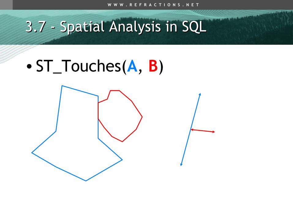
3.7 - Spatial Analysis in SQL3.7 - Spatial Analysis in SQL
•ST_Touches(A, B)

W W W . R E F R A C T I O N S . N E T
3.7 - Spatial Analysis in SQL3.7 - Spatial Analysis in SQL
•ST_Crosses(A, B)

W W W . R E F R A C T I O N S . N E T
3.7 - Spatial Analysis in SQL3.7 - Spatial Analysis in SQL
•ST_DWithin(A, B, D)
D

W W W . R E F R A C T I O N S . N E T
3.7 - Spatial Analysis in SQL3.7 - Spatial Analysis in SQL
• What is the total length of all roads in the province of BC, in kilometers?
• SELECT Sum( ST_Length( the_geom ) ) / 1000 AS km_roads FROM bc_roads;

W W W . R E F R A C T I O N S . N E T
3.7 - Spatial Analysis in SQL3.7 - Spatial Analysis in SQL
• How large is the city of PRINCE GEORGE, in hectares?
• SELECT ST_Area(the_geom)/10000 AS hectares FROM bc_municipality WHERE name = ‘PRINCE GEORGE’;

W W W . R E F R A C T I O N S . N E T
3.7 - Spatial Analysis in SQL3.7 - Spatial Analysis in SQL
• What is the largest municipality in the province, by area?
• SELECT name, ST_Area(the_geom)/10000 AS hectares FROM bc_municipality ORDER BY hectares DESC LIMIT 1;

W W W . R E F R A C T I O N S . N E T
3.8 - Basic Exercises3.8 - Basic Exercises
• What is the perimeter of the municipality of ‘VANCOUVER?’
• Hint – name = ‘VANCOUVER’• SELECT ST_Perimeter(the_geom)
FROM bc_municipality WHERE name = 'VANCOUVER';
W W W . R E F R A C T I O N S . N E T
3.8 - Basic Exercises3.8 - Basic Exercises
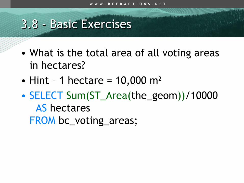
• What is the total area of all voting areas in hectares?
• Hint – 1 hectare = 10,000 m2
• SELECT Sum(ST_Area(the_geom))/10000 AS hectares FROM bc_voting_areas;
W W W . R E F R A C T I O N S . N E T
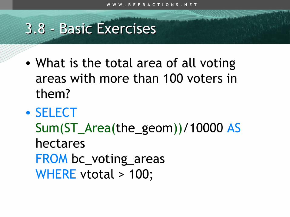
3.8 - Basic Exercises3.8 - Basic Exercises
• What is the total area of all voting areas with more than 100 voters in them?
• SELECT Sum(ST_Area(the_geom))/10000 AS hectares FROM bc_voting_areas WHERE vtotal > 100;
W W W . R E F R A C T I O N S . N E T
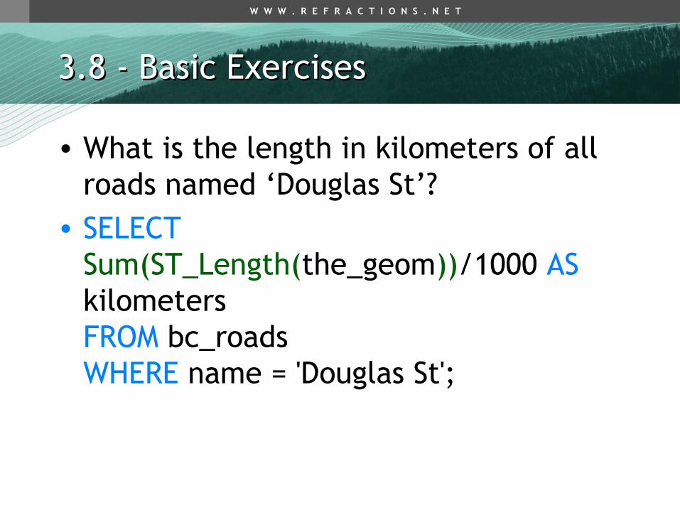
3.8 - Basic Exercises3.8 - Basic Exercises
• What is the length in kilometers of all roads named ‘Douglas St’?
• SELECT Sum(ST_Length(the_geom))/1000 AS kilometers FROM bc_roads WHERE name = 'Douglas St';

W W W . R E F R A C T I O N S . N E T
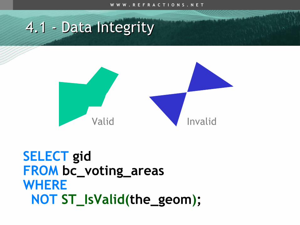
4.1 - Data Integrity4.1 - Data Integrity
• Spatial data algorithms embed expectations of structure
• PostGIS expects data to conform to the OGC Simple Features for SQL standard– Polygon rings don’t cross other rings
or self-intersect– Multi-polygons are non-overlapping– Interior rings can touch exteriors, but only
at one point– Ring orientation is unimportant
W W W . R E F R A C T I O N S . N E T
4.1 - Data Integrity4.1 - Data Integrity
Valid Invalid
SELECT gid FROM bc_voting_areas WHERE NOT ST_IsValid(the_geom);

W W W . R E F R A C T I O N S . N E T
4.1 - Data Integrity4.1 - Data Integrity
• 4897 is INVALID!• SELECT
ST_IsValid(ST_Buffer(the_geom, 0.0)) FROM bc_voting_areas WHERE gid = 4897;
• UPDATE bc_voting_areas SET the_geom = ST_Buffer(the_geom, 0.0) WHERE gid = 4897;

W W W . R E F R A C T I O N S . N E T
4.2 - Distance Queries4.2 - Distance Queries
• How many BC Unity Party supporters live within 2 kilometers of the ‘Tabor Arms’ pub?
• SELECT ST_AsText(the_geom) FROM bc_pubs WHERE name ILIKE ‘Tabor Arms%’;

W W W . R E F R A C T I O N S . N E T
4.2 - Distance Queries4.2 - Distance Queries
• SELECT Sum(unity) AS unity_voters FROM bc_voting_areas WHERE ST_Distance( the_geom, ST_GeomFromText(‘POINT(…)’, 3005), ) < 2000;

W W W . R E F R A C T I O N S . N E T
4.2 - Distance Queries4.2 - Distance Queries
• SELECT Sum(unity) AS unity_voters FROM bc_voting_areas WHERE ST_DWithin( the_geom, ST_GeomFromText(‘POINT(…)’, 3005), 2000 );

W W W . R E F R A C T I O N S . N E T
4.2 - Distance Queries4.2 - Distance Queries
• ST_DWithin(geometry, geometry, float)• SELECT
$1 && ST_Expand($2, $3) AND$2 && ST_Expand($1, $3) ANDST_Distance($1, $2) < $3

W W W . R E F R A C T I O N S . N E T
4.2.1 Distance Not Buffer4.2.1 Distance Not Buffer
• “What pubs fall within a 1km buffer of the roads?”
• You do not need to buffer to answer this question, because the return value is not a buffered road geometry, it is the pub.
• SELECT p.name FROM bc_pubs p, bc_roads rWHERE ST_DWithin(p.the_geom, r.the_geom, 1000)

W W W . R E F R A C T I O N S . N E T
4.2.1 Distance Not Buffer4.2.1 Distance Not Buffer
• This is the WRONG way to do it:• SELECT p.name
FROM bc_pubs p, bc_roads rWHERE ST_Contains( ST_Buffer(r.the_geom, 1000), p.the_geom );

W W W . R E F R A C T I O N S . N E T
4.3 - Spatial Joins4.3 - Spatial Joins
• Standard joins use a common key• SELECT a.var1, b.var2
FROM a, b WHERE a.id = b.id
• Spatial joins use the “universal key”, location
• SELECT a.var1, b.var2 FROM a, b WHERE ST_Intersects(a.geom, b.geom)

W W W . R E F R A C T I O N S . N E T
4.3 - Spatial Joins4.3 - Spatial Joins
• “Tabor Arms Pub” distance query as join• SELECT Sum(v.unity) AS unity_voters
FROM bc_voting_areas v, bc_pubs pWHERE ST_DWithin(v.the_geom, p.the_geom, 2000)AND p.name ILIKE 'Tabor Arms%';

W W W . R E F R A C T I O N S . N E T
4.3 - Spatial Joins4.3 - Spatial Joins
• Where are all of the pubs located within 250 meters of a hospital?
• SELECT bc_hospitals.name, bc_pubs.name FROM bc_hospitals, bc_pubs WHERE ST_DWithin( bc_hospitals.the_geom, bc_pubs.the_geom, 250 );

W W W . R E F R A C T I O N S . N E T
4.3 - Spatial Joins4.3 - Spatial Joins
• Summarize the 2000 provincial election by municipality
• SELECT m.name, Sum(v.ndp) AS ndp … Sum(v.vtotal) AS total FROM bc_voting_areas v, bc_municipality m WHERE ST_Intersects(v.the_geom, m.the_geom) GROUP BY m.nameORDER BY m.name;

W W W . R E F R A C T I O N S . N E T
4.4 - Overlays4.4 - Overlays
• Table-on-table overlays are possible with the ST_Intersection() function– ST_Intersects(a,b) returns BOOLEAN– ST_Intersection(a,b) returns GEOMETRY
ST_Intersects() = TRUE
ST_Intersection() =

W W W . R E F R A C T I O N S . N E T
4.4 - Overlays4.4 - Overlays
• Create a new table containing all voting areas that fall within PRINCE GEORGE clipped to that municipality’s bounds …

W W W . R E F R A C T I O N S . N E T
4.4 - Overlays4.4 - Overlays

W W W . R E F R A C T I O N S . N E T
4.4 - Overlays4.4 - Overlays• CREATE TABLE pg_voting_areas AS SELECT ST_Intersection(v.the_geom, m.the_geom) AS intersection_geom, ST_Area(v.the_geom) AS va_area, v.*, m.name FROM bc_voting_areas v, bc_municipality m WHERE ST_Intersects(v.the_geom, m.the_geom) AND m.name = ‘PRINCE GEORGE’;
W W W . R E F R A C T I O N S . N E T
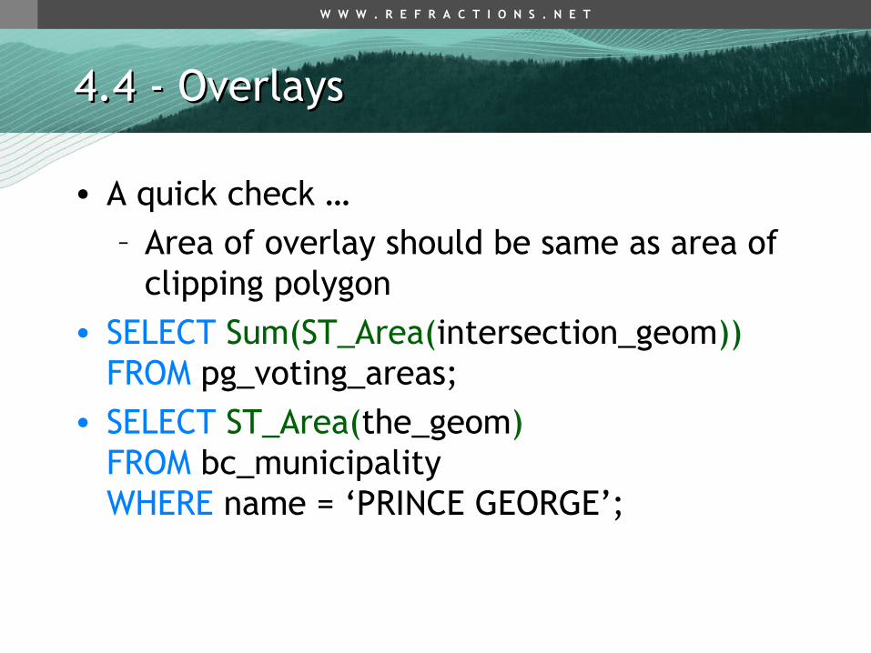
• A quick check …– Area of overlay should be same as area of
clipping polygon• SELECT Sum(ST_Area(intersection_geom))
FROM pg_voting_areas;• SELECT ST_Area(the_geom)
FROM bc_municipality WHERE name = ‘PRINCE GEORGE’;
4.4 - Overlays4.4 - Overlays

W W W . R E F R A C T I O N S . N E T
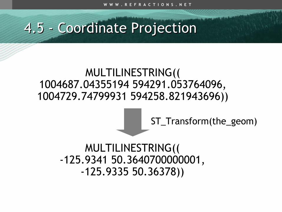
4.5 - Coordinate Projection4.5 - Coordinate Projection
• View the SRID of geometries using the ST_SRID() function
• SELECT ST_SRID(the_geom) FROM bc_roads LIMIT 1;
• What’s “3005”?• SELECT srtext
FROM spatial_ref_sys WHERE srid = 3005;
• Ah, it’s “BC Albers”

W W W . R E F R A C T I O N S . N E T
4.5 - Coordinate Projection4.5 - Coordinate Projection
• PROJCS[“NAD83 / BC Albers", GEOGCS["NAD83", DATUM["North_American_Datum_1983", SPHEROID["GRS 1980",6378137,298.257222101]], PRIMEM["Greenwich",0], UNIT["degree",0.01745329251994328], AUTHORITY["EPSG","4269"]], PROJECTION["Albers_Conic_Equal_Area"], PARAMETER["latitude_of_center",45], PARAMETER["longitude_of_center",-126], PARAMETER["standard_parallel_1",50], PARAMETER["standard_parallel_2",58.5], PARAMETER["false_easting",1000000], PARAMETER["false_northing",0], UNIT["metre",1], AUTHORITY["EPSG","3005"]]

W W W . R E F R A C T I O N S . N E T
4.5 - Coordinate Projection4.5 - Coordinate Projection
• What’s “3005” again?• SELECT proj4text
FROM spatial_ref_sys WHERE srid = 3005;
• +proj=aea +ellps=GRS80 +datum=NAD83 +lat_0=45.0 +lon_0=-126.0 +lat_1=50.0 +lat_2=58.5 +x_0=1000000 +y_0=0
• PROJ4 is coordinate re-projection library used by PostGIS

W W W . R E F R A C T I O N S . N E T
4.5 - Coordinate Projection4.5 - Coordinate Projection
• Coordinate Re-projection is done using the ST_Transform() function
• SELECT ST_AsText(the_geom) FROM bc_roads LIMIT 1;
• SELECT ST_AsText( ST_Transform(the_geom, 4326) ) FROM bc_roads LIMIT 1;
W W W . R E F R A C T I O N S . N E T
4.5 - Coordinate Projection4.5 - Coordinate Projection
MULTILINESTRING((1004687.04355194 594291.053764096,1004729.74799931 594258.821943696))
MULTILINESTRING((-125.9341 50.3640700000001,
-125.9335 50.36378))
ST_Transform(the_geom)

W W W . R E F R A C T I O N S . N E T
4.6 - Advanced Exercises4.6 - Advanced Exercises
• What is the length in kilometers of ‘Douglas St’ in ‘VICTORIA’?
• SELECT Sum(ST_Length(r.the_geom))/1000 AS kilometers FROM bc_roads r, bc_municipality m WHERE ST_Contains(m.the_geom, r.the_geom) AND r.name = 'Douglas St' AND m.name = 'VICTORIA';

W W W . R E F R A C T I O N S . N E T
4.6 - Advanced Exercises4.6 - Advanced Exercises
• What two pubs have the most Green Party supporters within 500 meters of them?
• SELECT p.name, p.city, Sum(v.green) AS greens FROM bc_pubs p, bc_voting_areas v WHERE ST_DWithin(v.the_geom, p.the_geom, 500) GROUP BY p.name, p.city ORDER BY greens DESC LIMIT 2;

W W W . R E F R A C T I O N S . N E T
4.6 - Advanced Exercises4.6 - Advanced Exercises
• What is the latitude of the most southerly hospital in the province?
• Hint – The SRID of lat/lon is 4326• SELECT
ST_Y(ST_Transform(the_geom,4326))AS latitude FROM bc_hospitals ORDER BY latitude ASC LIMIT 1;

W W W . R E F R A C T I O N S . N E T
4.6 - Advanced Exercises4.6 - Advanced Exercises
• What were the percentage NDP and Liberal vote within the city limits of Prince George in the 2000 provincial election?
• SELECT 100*Sum(v.ndp)/Sum(v.vtotal) AS ndp, 100*Sum(v.liberal)/Sum(v.vtotal) AS liberal FROM bc_voting_areas v, bc_municipality m WHERE ST_Contains(m.the_geom, v.the_geom) AND m.name = 'PRINCE GEORGE';

W W W . R E F R A C T I O N S . N E T
4.6 - Advanced Exercises4.6 - Advanced Exercises
• What is the largest voting area polygon that has a hole?
• Hint – A hole implies more than one ring• SELECT
gid, id, ST_Area(the_geom) AS area FROM bc_voting_areas WHERE ST_NRings(the_geom) > 1 ORDER BY area DESC LIMIT 1;

W W W . R E F R A C T I O N S . N E T
4.6 - Advanced Exercises4.6 - Advanced Exercises
• How many NDP voters live within 50 meters of ‘Simcoe St’ in Victoria?
• SELECT Sum(v.ndp) AS ndp FROM bc_voting_areas v, bc_municipality m, bc_roads r WHERE ST_DWithin(r.the_geom, v.the_geom, 50) AND ST_Contains(m.the_geom, r.the_geom) AND r.name = 'Simcoe St' AND m.name = 'VICTORIA';

W W W . R E F R A C T I O N S . N E T
5 Mapserver & PostGIS5 Mapserver & PostGIS
http://localhost/postgis
Start the application…
c:\ms4w\apps\postgis\htdocs\template.html

W W W . R E F R A C T I O N S . N E T
5.1 Basic Configuration5.1 Basic Configuration
LAYER CONNECTIONTYPE postgis NAME "bc_voting_areas” CONNECTION "user=postgres password=postgres dbname=postgis host=localhost" DATA "the_geom FROM bc_voting_areas" STATUS ON TYPE POLYGON CLASS COLOR 255 255 200 ENDEND

W W W . R E F R A C T I O N S . N E T
5.2 Filters and Expressions5.2 Filters and Expressions
• CONNECTIONTYPE, CONNECTION and DATA elements have unique PostGIS forms
• Most other Mapserver map file elements are the same using PostGIS
• There are two exceptions:– FILTER– EXPRESSION

W W W . R E F R A C T I O N S . N E T
5.2 Filters and Expressions5.2 Filters and Expressions
• For PostGIS connections, FILTER uses SQL “where clause” syntax instead of Mapserver expression syntax.
• FILTER “type = 6”• FILTER “name ilike ‘Dunbar%’”• FILTER “age > 6 and height < 4”

W W W . R E F R A C T I O N S . N E T
5.3 Mapserver with SQL5.3 Mapserver with SQL
• The Mapserver DATA statement can also use arbitrary SQL to compose spatial result sets for mapping.
• Useful when your data does not quite have the information you want to map, but it can be calculated or derived.

W W W . R E F R A C T I O N S . N E T
5.3 Mapserver with SQL5.3 Mapserver with SQL
• “Map the % voter turnout.”DATA "the_geom from (SELECT gid, the_geom, (case when vregist = 0 then 0.0 else vtotal::real / vregist::real end) AS percent FROM bc_voting_areas) as foo using srid=3005 using unique gid"

W W W . R E F R A C T I O N S . N E T
5.3 Mapserver with SQL5.3 Mapserver with SQL
• “Label the ‘important’ roads.”DATA "the_geom from (SELECT name,Sum(Length(the_geom)) AS length,Collect(GeometryN(the_geom,1)) AS the_geom FROM bc_roads WHERE the_geom && setsrid(!BOX!,3005) GROUP BY name ORDER BY length DESC LIMIT 5) as foo using SRID=3005, using unique name"
W W W . R E F R A C T I O N S . N E T
5.4 - Dynamic SQL5.4 - Dynamic SQL
• Take advantage of Mapserver %variable% substitution in CGI program
• Fill out SQL values on the fly to create new query result sets for mapping
• Very powerful tool, very easy to make use of

W W W . R E F R A C T I O N S . N E T
5.4 - Dynamic SQL5.4 - Dynamic SQL
DATA "the_geom from (SELECT the_geom,gid, ST_Distance(the_geom, SetSRID(MakePoint(%mx% + %img.x% * %mw% / %iw%, %my% - %img.y% * %mh% / %ih%), 3005)) AS dist FROM bc_roads) as foo using srid=3005 using unique gid

W W W . R E F R A C T I O N S . N E T
5.4 - Dynamic SQL5.4 - Dynamic SQL

W W W . R E F R A C T I O N S . N E T
5.5 - Very Dynamic SQL5.5 - Very Dynamic SQL
• Take the SQL insertion trick to its logical conclusion
• Provide a way to visualize arbitrary SQL queries on a map on the fly
• Using only the Mapserver CGI and a template based interface
• See the qlyr LAYER entry at the end of the example map file

W W W . R E F R A C T I O N S . N E T
5.5 - Very Dynamic SQL5.5 - Very Dynamic SQL
• DATA statementDATA "the_geom from (%sql%) as foo using SRID=3005 using unique gid"
• Template line<textarea name="sql" rows=3 cols=50>[sql]</textarea>
• Only trick is choice of Mapserver LAYER “TYPE”– Arbitrary SQL can return any geometry type

W W W . R E F R A C T I O N S . N E T
5.5 - Very Dynamic SQL5.5 - Very Dynamic SQL
Enter a SQL query and see it on the map outlined in red

W W W . R E F R A C T I O N S . N E T
5.5 - Very Dynamic SQL5.5 - Very Dynamic SQL
• Try some examples:• All roads that start with ‘B’• SELECT gid, the_geom
FROM bc_roads WHERE name LIKE ‘B%’
• All roads that are longer than 100 metres• SELECT gid, the_geom
FROM bc_roads WHERE ST_Length(the_geom) > 100

W W W . R E F R A C T I O N S . N E T
5.5 - Very Dynamic SQL5.5 - Very Dynamic SQL
• Buffered voting areas with Liberal vote > 100
• SELECT gid, ST_Buffer(the_geom,250) AS the_geom FROM bc_voting_areasWHERE liberal > 100

W W W . R E F R A C T I O N S . N E T
5.5 - Very Dynamic SQL5.5 - Very Dynamic SQL
• All roads inside the city of Victoria• SELECT r.gid, r.the_geom
FROM bc_roads r, bc_municipality mWHERE ST_Contains(m.the_geom, r.the_geom) AND m.name = ‘VICTORIA’

W W W . R E F R A C T I O N S . N E T
Thank You …Thank You …
Paul [email protected]
PostGIShttp://www.postgis.org
Mapserverhttp://mapserver.gis.umn.edu