inventory forms instructions - delaware · survey forms instructions and data coordination guidance...
TRANSCRIPT

DELAWARE STATE HISTORIC PRESERVATION OFFICE
SURVEY FORMS INSTRUCTIONS
AND
DATA COORDINATION GUIDANCE
Delaware State Historic Preservation Office
15 The Green Dover, DE 19901 302-739-5685 302-739-5660 (fax)

DE State Historic Preservation Office Revised October 2002 p. 1
INVENTORY FORMS INSTRUCTIONS █▌These instructions will help you complete Delaware’s Cultural Resource Survey forms. The Secretary of the Interior’s Standards for Identification require that information be systematically collected and recorded. The Delaware State Historic Preservation Office (DE SHPO) provides the system for collecting and recording information about Delaware’s historic properties. Using these forms helps provide complete information in a standard format, making it more useful for future researchers. It is important to complete all applicable forms, as each form is specifically designed for a particular type of resource.
GENERAL DIRECTIONS:
• Fill out all forms completely. Use N/A if an item is not applicable or zero if it=s asking for a number and there are none.
• With the exception of N/A or cardinal direction, do not use abbreviations on the final
forms. • Fill out forms in black ink only, either handwritten or typed, on heavy enough paper that
the ink does not bleed through. Generally this is about 30 lb paper for handwritten forms. The DE SHPO films all forms both to take up less room and to maintain security copies of all information. Because the final format is microfiche, black ink makes the best image. Never use colored inks to convey information because they do not film well.
• The Archaeological Site Form (CRS-4) and the Photographic Inventory Card (CRS-13)
must both be printed on card stock. • Respect private property rights. Fill out forms from the street, unless you are invited onto
the property by the owner and/or resident. If you cannot fill out part of the form because it is not visible from the street, just note “not visible” on the form.
• If more space is needed, use a plain sheet of 8½” by 11” paper, with name, address, and
CRS number of the property noted at the top. • If you have questions on which forms to use, or how to fill them out, call the DE SHPO at
302-739-5685.
The DE SHPO is now making the forms available electronically. Even if you use electronic forms, do not print them in color. There should be no color on any CRS forms.

DE State Historic Preservation Office Revised October 2002
█▌ Property Identification Form (CRS-1)
This form provides information on the property=s location, associatplanning contexts, and general notes. Fill this out for every locationsites. Boundaries of building and structure properties usually confothe property you are describing is found. However, the Delaware SHsites by natural boundaries such as streams, that may involve less thparcel. (front upper right corner): This information is generally obtained at the end of the field work aportion of the survey. (See the Data Coordination Guidance.) CRS #: The DE SHPO will assign the Cultural Resource Survey (Csurvey is complete. Use a penciled temporary field number until theobtained. The CRS number must be noted on all forms, both sides,documentation pertaining to the resource, including maps, floor planphotographs, and reports. SPO Map: This number notes on which of the DE SHPO’s base m(These aerials were flown in 1964 and were acquired from the Statehave a scale of 1"= 800’. DelDOT now has the original Mylar maps Hundred: The name of the hundred in which the resource is locatefrom the SPO Map.) Quad: The name of the USGS 7.5’ topographic quadrangle map onlocated. (This can be obtained from the SPO Map.) Other: Use this space to record tax parcel number if known, or anymay want to record. 1. HISTORIC NAME/FUNCTION: Record the historic nam
The name can include the main function or structural form o
Fig. 1. An agricultural complexnear Frederica, K-2792 Fig. 2. Part of the Dover GreenHistoric District, K-394p. 2
ions with the state=s , including archaeological rm to the tax parcel on which
PO defines archaeological an or more than a single tax
s part of the data coordination
RS) number after the field permanent number can be
and on all other s or other drawings,
aps the property is mapped. Planning Office; the maps .)
d. (This can be obtained
which the resource is
other map reference you
e of the property, if known. f the property. The historic

DE State Historic Preservation Office Revised October 2002 p. 3
name is the one given to the property historically or is the name of the original builder of the property or of a significant individual associated with the property found through documentary research. If more than one name is found, they can be hyphenated. The historic name can be taken from Beers’ Atlas of Delaware or a similar atlas. The source, such as Beers, should be noted on the form. In naming properties, the current landowner’s name is not used except in the case of archaeological sites where no historic name exists. For Native American sites, use the landowner’s name or a descriptive geographical term; for historic period sites, use an associated historic owner’s name from such sources as Beers’ Atlas of 1868, another appropriate map, or a deed.
Historic Name Examples: The Maples (Beers’); H. Jenkins (Ray & Price) Dwelling; St. Anthony’s R.C. Church; Bridge 405; Burton=s Hardware Store; H. Wilson House Site
If no historic name is known, a built property is known by its function and street address.
Function Examples: Dwelling, 305 Maple Street; Agricultural
Complex, N side Route 15 E of intersection with Road 324; Store, NE Corner of North and Elm streets
Native American Archaeological Site Examples: Thompson’s Island Site; Barnes Woods Archeological District; Townsend Area A; Dill Farm Site
2. ADDRESS/ LOCATION: Provide the street address of the property. Indicate which
side of the road or intersection using cardinal directions. (Delaware is covered by a 911 emergency system; all places should now have named roads with house numbers.) For an archaeological site or abandoned building unassociated with an address, describe the location with approximate distances from and direction to named tributaries and nearby roads.
3. TOWN/NEAREST TOWN: Provide the name of the town that the resource is located
in, or that it is nearest to. Put a check in the “vicinity?” box if not within the incorporated limits of the town.
4. MAIN TYPE OF RESOURCE: Check the most appropriate type using the National
Register definitions. (For definitions of these terms, see NR Bulletin 16, p. 15; for landscape, see NR Bulletin 30, p.3.1)
5. MAIN FUNCTION OF THE PROPERTY: Give the main or most visible purpose of
the entire resource. 1 Nearly all the NR Bulletins are now available on line at www.cr.nps.gov/nr/publications/bulletins.htm. The DE SHPO also has copies available upon request.

DE State Historic Preservation Office Revised October 2002 p. 4
Example: dwelling; farm; mill; domestic site; procurement site 6. PROJECT TITLE/REASON FOR SURVEY (if applicable): Give the project title, if
one exists, and/or the reason that the survey is being done.
Example: Rehoboth Beach Architectural Survey (HPF Grant)
Example: Oak Orchard Sanitary Sewer District Project (Section 106) 7. ADDITIONAL FORMS USED: Give the number of forms completed for each
additional form type. Put zero (0) for forms not used. List by property type each building, structure, site, and/or object.
Example: 2 CRS 2 Main Building Form: Dwelling, grist mill Example: 3 CRS 6 Structure (Land Feature) Form: Mill pond, dam,
water control structure
8. SURVEYOR INFORMATION: The names of both the surveyor and the principal investigator (PI) need to be printed or typed here. In addition, the PI must sign the form. By doing this, the PI is certifying the accuracy of the information provided. Give the name of the organization that you work for, along with the date the form was filled out.
9. OTHER NOTES OR OBSERVATIONS: Record any observations and additional data
from field survey, including oral history. This may include important individuals, such as former residents or patrons associated with the property and/or individual resources on the property. Note any additional or local names for the property. Include the relationship of the resource to its setting, noteworthy features of the property, threats to the property, and any additional documentation known. Cite sources for the information.
Examples: owner has historic photos; 1926 USGS map shows houses lining street in vicinity of present-day empty lots; fully-paneled interiors, winder stairs from basement to attic; demolition permit 6/25/91; HABS, 1932; locally known as the Westwood Terrace House.
10. STATE COMPREHENSIVE PLANNING: Check all applicable time period(s),
geographical zone, and theme(s).

D
█▌ Main Building Form (CRS-2)
Tartm Isa NWp ( C 1 2
3
Fig. 5. Bancroft and Sons Cotton Mills, N-3646
Fig. 3. house in Bethel HistoricDistrict, S-195.073
E State Historic Preservation Offic
he purpose of this form is to record dwelling, church, mill, etc., that deecords materials, plan, decorative elhan one Main Building Form; for ex
ill, both the house and the mill are
f access to the interior of the buildinketch plan of the first floor, on a pland CRS number noted at the top.
ote for industrial buildings: Use thhen surveying industrial buildings,
ower source, and materials storage,
front upper right corner):
RS #: Same as on Property Identif
. ADDRESS/LOCATION: S
. FUNCTION: Record both ha list of functions and physica
Examples: single-fam
. YEAR BUILT: Unless exacfeatures, massing, constructioif the surveyor believes the dagiven.
Fig. 4. Bridgeville Fire House,S-809
e Revised October 2002 p. 5
construction information about a standing building, such as fines one of the main uses of the overall property. This form ements, and construction technology. There can be more ample, if the property contains a miller’s house and grist described on Main Building Forms.
g is available, describe the interior details, including a in sheet of 8½” by 11” paper, with property name, address,
e Main Building Form and any other appropriate forms. take note of the areas for workers, office/management, and how these are separated.
ication Form.
ame as Property Identification Form, line 2.
istoric and current function(s). (See Ames, et al., 1989, for l property types.)
ily dwelling; store; physician=s office; woolen mill
t year is known, approximate the year based on stylistic n materials, and/or other visual clues. Check the circa box te of construction is within 5 years before or after the year

DE State Historic Preservation Office Revised October 2002 p. 6
ARCHITECT/BUILDER: Provide the name of individual, firm, or company who built or designed the building, if known and can be documented.
Examples: Sears and Roebuck Catalog House; William Strickland.
4. STYLE OR FLOOR PLAN: Note main style and any hints of national styles that may
be on Delaware vernacular buildings. Stylistic details that have been added to an older building should also be cited. If there is no style, describe the floor plan of main block.
Example 1: Queen Anne with Classical Revival detailing.
Example 2: 3-bay, center-passage, single pile, with Colonial Revival details.
5. INTEGRITY: Check the appropriate box to note whether the building is on its original
site or has been moved. Supply year(s) and original or earlier location(s) if known and cross-reference any CRS numbers for the original or earlier location(s) if already assigned. Record major alterations with years of construction. Talk to owners if possible.
6. CURRENT CONDITION: Check the applicable condition, using these definitions:
Excellent: recently repaired and fully functional.
Good: basically sound and functional with some maintenance needed.
Fair: deterioration evident and not fully functional.
Poor: advanced deterioration evident, with compromised function, even to the loss of major elements, and major reconstruction re-quired.
7. DESCRIPTION: Fill out the form as completely as possible with the information available. Use N, S, E, and W directions throughout the description. Provide a thumb-nail sketch of unusual features, on a continuation page if necessary. Leave no blank spaces. Use N/A (not applicable) for items on the form that are not present. If a feature is not accessible or not visible, like a brush-covered foundation or an interior, spell out the phrase.
a) Overall shape: Describe the outline of the plan of the building. If there are later additions, describe both the historic shape and the current shape.

DE State Historic Preservation Office Revised October 2002 p. 7
Examples: T-shape; L-shape; square; rectangular
stories: Record the number of full-height, floor-to-ceiling levels between the foundation and the attic. The attic counts as a half-story if it has some exterior feature that distinguishes it as another level, such as wall dormers or turrets.
additions: Give the number of stories and location of additions to the main block.
b) Structural system: Record the construction technique and primary material used to construct the principal weight-bearing walls.
Examples: braced frame; balloon frame; stone- veneered platform frame; brick-bearing; concrete block; structural steel with curtain walls.
c) Foundation:
materials: Record the materials used in the foundation of the main block and any additions.
Examples: parged brick; concrete block; brick pier.
basement: Check the appropriate box.
d) Exterior walls: List the original, if known, and any subsequent siding changes. For each elevation, specify material, and describe details specific to that type.
Examples: cast-concrete pattern block; clapboard with corner boards; brick – 7-course common bond; asphalt shingle with brick pattern.
e) Roof:
shape: Use common architectural terminology.
Examples: gable; hip; gambrel; mansard with cross gable.
materials: Note the roof covering.
Examples: asphalt shingles; slate shingles; wood shingles; standing seam metal.

DE State Historic Preservation Office Revised October 2002 p. 8
cornice: Describe the eave treatment of the main block and additions(s), noting decorative features.
Examples: exposed rafter ends and knee braces; decorative barge-board; box.
dormers: Describe location, roof shape, materials, decorative treatment, and whether or not they are original.
chimney: location(s): Describe details of construction, exterior or interior, placement, and any other decorative treatment.
Example: interior, end brick chimney with terracotta chimney pot; exterior stove chimney on rear wing.
8. DESCRIPTION OF ELEVATIONS: The elevation is any part of the building that is
visible when looking directly at that side. Make a note if sections of the elevation are not in the same plane. Give cardinal direction for each elevation. Note if any elevation is not visible or is inaccessible. Note any blocked or cut in elements. An elevation sketch on a separate, plain sheet of 8½” x 11” paper can be used to provide detailed information about a specific feature or view of a building. a-d) Façade/Side/Rear: Note cardinal direction.
1) bays: Note the number of bays. A bay is a vertical division of an elevation of a building. Usually the doors and windows across the first floor define the bays.
2) Windows: Record all features of windows.
fenestration: Count the number of windows in each story of the elevation and describe their distribution pattern. The term regular means identical-width windows in each bay and on each floor; if not regular, describe the arrangement.
Examples: regular w/3 windows per floor; large plate-glass window across both E & central bays on 1st floor, w/a smaller window in both the E & central bays of the 2nd floor, w/ the W bay filled in.
type: Note type and overall shape of window. Record the number of lights.
Examples: 6/6 sash; diamond and lozenge over 1 double

DE State Historic Preservation Office Revised October 2002 p. 9
hung sash; Chicago window with 1/1 double hung sash flanking a larger fixed pane.
trim: Note all decorative elements or distinctive features.
Examples: marble lug sills; plain board surrounds; sawn brackets.
shutters: Note material, type, and hardware, and if historic or not.
Example: operable louvered shutters with shutter dogs; fixed vinyl shutters.
3) Door:
location: Describe location of door(s).
type: Record shape of opening and type of door.
Example: batten; double paneled doors; top half: raised horizontal panel over one light, bottom half: three square raised panels over two horizontal raised panels.
trim: Describe treatment of door surround.
Examples: 4-light flat transom; shouldered surround; fanlight with wrought iron sun-burst.
4) Porch(es): Note size and position of porches, stoops, and porte cocheres.
Items to include as applicable: number of stories, roof shape, materials, supports, and trim.
Examples: Full width porch with central entrance, simple square wood columns, screen enclosed, flat roof with modern picket balustrade above, concrete block foundation and stoop with poured concrete deck.
9. INTERIOR: Ask the owner or occupant about any significant interior features. Draw an
interior plan when it is accessible. Note details such as fireplaces, staircases, and built-in cabinetry. Draw a separate sketch for each level. Use a plain sheet of 8½” by 11” paper, with name, address, and CRS number of the property noted at the top.
10. LANDSCAPING: Describe the relationship between the building and its immediate
DE State Historic Preservation Office Revised October 2002 p. 10
surroundings. If there is a larger landscape that the building relates to, complete the Landscape Elements Form (CRS-8).
Examples: planting beds; specimen trees; Colonial Revival garden; agricultural field to the door.
11. OTHER COMMENTS: Record any details that do not easily fall into another category.

D
█▌ Secondary Building Form (CRS-3)
Tre ( C 1 2
3
4
5
Fig. 9. Swine house at Buena Vista, N-219.011
Fig. 6. Smokehouse at the Gov. William H. Ross House, S-197
E State Historic Preservatio
he purpose of this form is toelated to a main building ideven those less than fifty year
front upper right corner):
RS #: Same as on Property
. ADDRESS/LOCATI
. FUNCTION: Recordlist of general functionthat context.)
Example: cor
. YEAR BUILT: Givematerials, function, stthe surveyor believes given.
ARCHITECT/BUIL
. STYLE/FLOOR PLassociated with local o
. INTEGRITY: Checsite or has been movecross-reference any Cmajor alterations with
Fig. 7. Bank barn at theDayett Miller’s House in the Cooch’s Bridge Historic District, N-190.068
n Office Revised O
record information abountified on a Main Buildins old, should be surveyed
Identification Form.
ON: Same as Property I
both historic and currens and property types; see
n crib; dairy barn; garage
year if known or approxylistic influences, and datthe date of construction i
DER: Provide name of
AN: Record type of floor national trends.
k the appropriate box to nd. Supply year(s) and oriRS numbers for the origi years of construction. T
Fig. 8. Oil storage shed at the Reedy Island Range Rear Light, N-5120
ctober 2002 p. 11
t any secondary building or outbuilding g Form (CRS-2). All secondary buildings, .
dentification Form, line 2.
t functions. (See Ames, et al., 1989, for a individual contexts for types specific to
; manager=s office; storage shed.
imate year based on construction e of main building. Check the circa box if s within 5 years before or after the year
designer or builder if known.
r plan and/or any stylistic features
ote whether the building is on its original ginal/earlier location(s) if known and nal location(s) if already assigned. Record alk to owners if possible.

DE State Historic Preservation Office Revised October 2002 p. 12
6. CURRENT CONDITION: Check the applicable condition, using these definitions:
Excellent: recently repaired and fully functional.
Good: basically sound and functional with some maintenance needed.
Fair: deterioration evident and not fully functional. Poor: advanced deterioration evident, with compromised function, even to the loss of major elements, and major reconstruction re-quired.
7. DESCRIPTION: Document the historic and current features. Use N, S, E, and W
directions throughout.
a) Structural system: Note construction technique and materials.
Examples: balloon frame; load-bearing brick
b) Number of stories: Record the number of full-height, floor-to-ceiling levels between the foundation and the attic. The attic counts as a half-story if it has some exterior feature that distinguishes it as another level, such as wall dormers or gables.
c) Wall coverings: Note the original exterior wall surface (if accessible) and subsequent siding changes.
Examples: asphalt shingle over clapboard; vertical board siding
d) Foundation: Note the materials and type of foundation.
Examples: brick piers; poured concrete slab
e) Roof:
structural system: Describe the shape, cornice treatment, and construction techniques, if accessible.
Example: gable w/exposed rafter ends & butt joints nailed w/ wire nails
coverings: Note materials, both historic (if visible) and current.

DE State Historic Preservation Office Revised October 2002 p. 13
Example: rolled asphalt over wood shingle
openings: Describe locations, materials, and decorative treatment of roof openings.
Example: central chimney flue; metal ventilator with cow weather vane
8. DESCRIPTION OF ELEVATIONS: The elevation is any part of the building that is
visible when looking directly at that side. Make a note if sections of the elevation are not in the same plane. Give cardinal direction for each elevation. Note if any elevation is not visible or is inaccessible. Note any blocked or cut in elements. An elevation sketch on a separate, plain sheet of 8½” x 11” paper can be used to provide detailed information about a specific feature or view of a building. a-d) Façade/Side/Rear: Note cardinal direction.
1) bays: Note the number of bays. A bay is a vertical division of an elevation of a building. Usually the doors and windows across the first floor define the bays.
2) windows: Describe the type, trim, and spacing pattern for the window. Note “none” if there are no windows.
Example: 6/6 double-hung sash window with simple wood surround; none.
3) doors: Describe the type, trim, and spacing pattern for any doors.
Example: single door centered w/simple board trim surround; none.
4) other: Describe the type, spacing, and any other details for any other openings.
Example: diamond-shaped, louvered attic vent.
9. INTERIOR: Draw an interior plan when it is accessible. Draw a separate sketch for
each level. Use a plain sheet of 8½” x 11” paper, with name, address, and CRS number of the property noted at the top.
a) Floor plan: Describe overall shape, noting later additions and location of interior stairs, ramps, etc.
DE State Historic Preservation Office Revised October 2002 p. 14
Example: rectangular w/ladder access to loft
b) Partitions/walls: Record the number of bays and the materials used to subdivide the interior space. Illustrate these divisions of space on the sketch map.
Example: 3 bays, w/ central drive bay, ½-high horizontal board parti-tions, bins on E wall, 3 horse stalls on W wall
c) Finishes: Note treatment of surfaces.
Example: whitewash; covered with plywood 1/3 way up on E wall.
d) Furnishings/machinery: Describe built-in furnishings.
Example: iron stanchions; wood pulleys

DE State Historic Preservation Office Revised October 2002 p. 15
█▌ Archaeological Site Form (CRS-4)
The purpose of this form is to record the physical description and basic cultural information for archaeological sites. It must be printed on 8 ½” x 11”cardstock. (front upper right corner): CRS #: Same as on Property Identification Form. Site #: The site number is obtained from the DE SHPO at the same time as the CRS number. (See Data Coordination Guidance for more information on assigning site numbers.) Soil Map #: The county initial and map number from the SCS Soil Survey books (1974). 1. INFORMANT: If applicable, give the name of the person who provided the site
information with his/her relationship to the property.
Examples: collector; land owner 2. SURFACE CONDITION: describe the surface condition(s) of the site, marking all
applicable setting types. Use “other” for a more detailed description of sites that do not fall into one of the other categories. Describe the apparent integrity.
Example: partially built on; severely deflated; appears intact
3. SOIL TYPE: Use the designation(s) from the U.S. Soil Conservation Service Soil
Survey books.2 4. DESCRIPTION OF FIELD WORK: check all applicable types of survey and/or
excavation methods used. If surface collection is marked, include the percentage of 2 DE SHPO is aware that soil types are now being updated and renamed. However, until this information is available, use the 1974 books.
Fig. 10. The Thompson’s Loss and Gain Site, S-769/7S-G-60
Fig. 11. The Thompson’s Loss and Gain Site, pattern of earthfast house after excavation, S-769/7S-G-60

DE State Historic Preservation Office Revised October 2002 p. 16
visible surface. 5. COLLECTIONS:
a-d) Repository: Note name of repository. If not in Delaware, note state.
Accession #: Obtain this number from Delaware State Museums (DSM) Delaware Archaeological Collections repository or other repository, after obtaining the site number.
Collector/consultant: Note the individual or organization obtaining the artifacts.
Date: Give the date of field work.
Surface: Check if a surface collection is included.
Excavation: Check if an excavated collection is included.
6. ARTIFACTS: Describe the general artifact types and/or classes of materials found.
Example: jasper side scraper; rhyolite Fox Creek point; olive bottle glass; brick.
7. FEATURES: List the types of major features found on the site. (Do not give detailed
descriptions of individual features.)
Example: foundation; trash pits; burials; fence lines.
8. DOCUMENTATION:
Publication/report title and year: Note any published or unpublished reports on file in a repository or at DE SHPO, and give the year of publication.
Supporting documentation: Check the appropriate boxes if that information is on file with the artifacts at the repository noted above.
Other: Describe any other supporting documentation included.

DE State Historic Preservation Office Revised October 2002 p. 17
█▌ Structure (Building-Like) Form (CRS-5)
This form is for recording those structures that are more building-like in nature. Examples are structures such as silos, water towers, gazebos, bandstands, grain elevators, kilns, and windmills. Specific forms exist for aids to navigation and bridges but because these property types have already been surveyed statewide, the forms are not included here. If you should need one, contact the DE SHPO. Surveys for specific property types can develop specific forms as needed in consultation with the DE SHPO. If you are documenting a structure that doesn’t fit into any of the standard forms, or if you have questions about which structure form to use, please contact DE SHPO at 302-739-5685. (front upper right corner): CRS #: Same as on Property Identification Form. 1. ADDRESS/LOCATION: Same as Property Identification Form, line 2. 2. FUNCTION: Record historic function. (See Ames, et al., 1989, for a list of functions
and property types.) Check the box if still in use.
Examples: water tower for Town of Townsend 3. YEAR BUILT: Provide the year of construction, if known. Approximate the year based
on stylistic or technological type. Check the circa box if the surveyor believes the date of construction is within 5 years before or after the year given.
ARCHITECT/BUILDER: If known, provide the name of the architect, engineer,
builder, and/or contractor. 4. STYLE/PLAN: Describe the style, type, or defining features and/or describe the general
plan. 5. INTEGRITY: Indicate if the structure is on its original site or if it has been moved. If
Fig. 12. Silo at Buena Vista, N-219.008
Fig. 13. Lime kilns, in the Eastburn-Jeanes Lime Kilns Historic District, N-194

DE State Historic Preservation Office Revised October 2002 p. 18
known, provide the date of the move, and note its original location. List major alterations and years if known.
6. CURRENT CONDITION: Check the applicable condition.
Excellent: recently repaired and fully functional.
Good: basically sound and functional with some maintenance needed.
Fair: deterioration evident and not fully functional.
Poor: advanced deterioration evident, with compromised function, even to the loss of major elements, and major reconstruction required.
7. DESCRIPTION: An interior plan and/or elevation sketch can be used to provide
detailed information about the plan, a specific feature, or view of a structure. Use a plain sheet of 8½” x 11” paper, with name, address, and CRS number of the property noted at the top.
a) Overall shape: Describe the form of the structure.
height, length, width: Give dimensions.
b) Structural system: Note construction technique and materials.
Examples: steel girder; timber frame
c) Foundation: Note the type and material.
d) Exterior covering: Note the type and material and where each type is located.
e) Openings: Describe any openings, such as doors, windows, vents, or access ways. Indicate relative size, location, and material.
f) Other features: Note any other features.

DE State Historic Preservation Office Revised October 20
█▌ Structure (Land Feature) Form (CRS-6)
This form is for recording those structures that are man-made altExamples are: canals, dams, earthworks, water control systems,ditches, marsh dikes, and breakwaters. If you have a question abplease contact DE SHPO. (front upper right corner): CRS #: Same as on Property Identification Form. 1. ADDRESS/LOCATION: Same as on Property Identifi 2. FUNCTION: Record historic function. (See Ames, et a
and property types.) Note whether still in use.
Example: road bridge for Rt. 13; dam for grist m 3. YEAR BUILT: Provide the year of construction, if kno
on stylistic or technological type. Check the circa box if construction is within 5 years before or after the year giv
4. INTEGRITY: List all changes that have occurred and y 5. CURRENT CONDITION: Check the applicable condi
Excellent: recently repaired and fully functional.
Good: basically sound and functional with some
Fair: deterioration evident and not fully function
Poor: advanced deterioration evident, with compto the loss of major elements, and major reconstru
Fig. 14. Rockland Mills race, N-343.070
Fig. 15. Seawall around PeaPatch Island, from the top ofFort Delaware, N-145
02 p. 19
erations to the landscape. irrigation systems, drainage out which structure form to use,
cation Form, line number 2.
l., 1989, for a list of functions
ill (demolished)
wn. Approximate the year based the surveyor believes the date of en.
ear if known.
tion.
maintenance needed.
al.
romised function, even ction required.

DE State Historic Preservation Office Revised October 2002 p. 20
6. DESCRIPTION:
a) Circulation system: Describe any type of road or paths related to the structure. Note surface materials.
b) Spatial subdivisions: Describe visually or functionally distinct sub-areas.
c) Retaining wall/lining material(s): Describe materials if the resource is lined or has some type of exterior support. If not, put N/A.
d) Other: Include any information that does not fit in any category above.

DE State Historic Preservation Office Revised October 2002 p. 21
█▌ Object Form (CRS-7)
The purpose of this form is to describe the physical appearance of objects, including materials, technology, artistic character, and setting. (front upper right corner): CRS #: Same as on Property Identification Form. 1. ADDRESS/LOCATION: Same as Property Identification Form, line number 2. 2. TYPE/FUNCTION/TITLE: Note these items as applicable. Use title for named pieces
of artwork.
Example: Ellendale Veterans Memorial; fountain; Railroad train signal 3. YEAR: Construction: Note year the object was created, if known. Installation: Note
year the object was installed, if known. Previous location(s): Note any, if known.
Example: Construction: 1880; Installation: 1900; Previous location(s): Albany, NY.
4. DESIGNER/FOUNDER/SCULPTOR: Abbreviations or full name may appear on an
attached plaque, on the side or back of a sculpture, on a plate on a wrought iron fence, or elsewhere. Record all information found.
5. SPONSOR/OWNER: Record name of historic owner or individual/company that
sponsored the creation of the object. 6. STYLE: Where possible, indicate stylistic tradition into which object would best fit.
Fig. 16. The 1937 monument at Fort Christina State Park, N-338
Fig. 17. Mason –Dixon boundary marker, D-101
Fig. 18. The Highball Signal, S-191

DE State Historic Preservation Office Revised October 2002 p. 22
Examples: Egyptian Revival (tombstone); Art Nouveau (lamppost) 7. CURRENT CONDITION: Check the applicable condition, using these definitions:
Excellent: no repair needed.
Good: basically sound with some repair needed.
Fair: deterioration evident with major repair needed.
Poor: advanced deterioration, even to the loss of major elements, and major reconstruction required.
8. DESCRIPTION: An elevation sketch can be used to provide detailed information about
a specific feature or view of an object. Use a plain sheet of 8½” x 11” paper, with name, address, and CRS number of the property noted at the top.
a-b) Object/Base:
form: Note overall shape and mass.
Examples: octagonal, elongated (lamppost); geometric cube (public sculpture); Venus de Milo replica (garden sculpture); obelisk (boundary marker); post-&-rail (fence).
technology and material: Describe method of design or construction and materials.
Examples: lost wax cast bronze; wrought iron; split rails with earthfast posts; cast concrete.
surface finish: Note presence of paint and its color, and describe texture of surface.
Examples: polished; rough hewn; hammered; sawn and whitewashed.
decoration: Describe applied, carved, molded, or painted decoration.
dimensions: Give approximate dimensions of the object or base, separate from each other.
alterations or changes: Note any missing parts, added pieces, or other apparent

DE State Historic Preservation Office Revised October 2002 p. 23
changes to the original form.
c) Inscriptions:
location: Describe position on object or base where foundry/sculptor marks and/or inscription is located.
lettering: Note style of lettering.
Example: block; script.
text: Transcribe and photograph text.
d) Other: Note any other descriptive information that does not fit in any other category.

DE State Historic Preservation Office Revised October 2002 p. 24
█▌Landscape Elements Form (CRS-8)
The purpose of this form is to document landscape features which are not easily recorded on other forms, such as cemeteries and gardens. Use this form for any historic elements that contribute to the setting of a historic property or that constitute a historic site in themselves. For example, record the overall form and elements of historic subdivisions, parks, cemeteries, estates, and gardens on this form. Also use this form for additional information on agricultural properties where the setting retains a high degree of integrity. For industrial and commercial properties with a working yard, describe the historic elements which do not fit on other forms, such as railroad sidings and docks, fenced compounds, wharves and piers, and those elements between the buildings and structures that contribute to a better understanding of the use of the site. If necessary, use multiple Landscape Elements forms to describe the sub-areas of a resource. If you have any questions, please contact the DE SHPO. (front upper right corner): CRS #: Same as on Property Identification Form. 1. ADDRESS/LOCATION: Same as Property Identification Form, line number 2. 2. TYPE/FUNCTION/NAME: Note these items as applicable.
Examples: Oddfellows Cemetery; orchard; rose garden; Brandywine Park 3. YEAR BUILT: Note the year the landscape was created or designed. Use exact year or
circa to indicate approximate range of 5 years before or after year given.
alteration(s): Note approximate year and type of major changes. These include changes in land forms, demolition of buildings/structures, construction of new facilities, or complete replacement/loss of major plantings.
4. DESIGNER: Give name of the person(s) or company(s) responsible for the original or
later planning and/or design of the landscape. Include names of landscape architect, designer, and/or planner, if known.
Fig. 19. Arbor in garden at Garrett Mills Superintendent’s House, N-329
Fig. 20. Cemetery at Barratt’s Chapel, K-103

DE State Historic Preservation Office Revised October 2002 p. 25
5. STYLE: Describe, if any, the stylistic tradition or influence that best describes the
landscape. Examples: Colonial Revival (garden)
6. CURRENT CONDITION: Check the applicable condition, using these definitions:
Excellent: no repair needed.
Good: basically sound with some repair needed.
Fair: deterioration evident with major repair needed.
Poor: advanced deterioration, even to the loss of major elements, and major reconstruction required.
7. RELATIONSHIP TO OTHER PROPERTIES: Note properties that have historical
ties to this landscape.
Example: Sundial Garden at Winterthur (for Gibraltar gardens designed by Marian Coffin); Rockford Park (for Brandywine Park)
8. DESCRIPTION:
a) Scenic views/vistas: Describe any viewsheds presently discernable. Give direction and describe focal point. Note any alterations or intrusions.
b) Circulation system: Describe street pattern, path system, trails, waterways, or other rights-of-way providing access to and within the landscape.
c) Spatial subdivisions: Describe functional sub-areas that do not merit an individual Landscape Element Form.
Examples: playground; farm fields; loading area.
d) Paving material(s): Describe paving materials for roads, sidewalks, and trails. Note whether or not historic fabric is present.
e) Utilities: Describe historic utility features not noted on an individual Object Form.
Examples: historic light fixtures; sprinkler system; drain system.

DE State Historic Preservation Office Revised October 2002 p. 26
f) Water elements: Describe water features not part of circulation system, and not described on an individual Structure (Land Feature) or Object form.
Examples: reflecting pool; stream; farm pond.
g) Vegetation: Describe plant material to the best of your knowledge.
Examples: allee of deciduous trees; scattered specimen trees; Osage orange hedgerow; herb garden; flower border.
h) Other: Describe any detail worth noting that does not fit within the above categories.

DE State Historic Preservation Office Revised October 2002 p. 27
█▌ Map Form (CRS-9) This form is to allow adequate space to sketch a location map as well as a site plan of all elements. (Note that the form designed for paper use includes a grid of dots to simplify sketching; this does not appear on the one designed purely for digital use.) (front upper right corner): CRS #: Same as on Property Identification Form. 1. ADDRESS/LOCATION: Same as Property Identification Form, line number 2. 2. NOT FOR PUBLICATION: Check this box if archaeological resources are present, if
the property is a traditional cultural property with religious significance, or if the property contains other sensitive information that needs to have the location information restricted. Note reason for restriction.
3. LOCATION MAP: The purpose of this map is to show the location of the property in
relation to major features such as roads, streams, and nearby population centers. This can be a sketch map, or you can attach or insert part of the USGS 7.5’ topographic map with the location clearly marked on it.
Locate the property by showing the approximate distance to the nearest intersection,
street, or road. For archaeological sites, this should include an approximate distance to water. Note street names and/or numbers, record other historic properties in the vicinity, and provide a north arrow. Indicate the property by drawing a circle around the entire property location if not immediately obvious from the map.
4. SITE PLAN: A Site Plan must be drawn for all surveyed properties, except
archaeological sites. It includes buildings, structures, objects, and significant landscape features. If an archaeological site contains visible ruins or significant landscape features, then draw a site plan.
The site plan is drawn from a bird’s eye view. Include north arrow. For buildings, show the relationship of the main block or core building to the wings, additions, and porches, along with other buildings, structures, and objects on the property. Different periods of construction should be noted. Note window, door, chimney, and ridge of roof locations. Include landscape features such as circulation systems, major plantings, and water features. The map can also include annotations with approximate dimensions, number of stories, and function of space(s) or landscape sub-areas. Architectural drawing conventions should be observed.

DE State Historic Preservation Office Revised
█▌ Survey Update Form (CRS-10)
The purpose of this form is to provide updated manaproperties previously surveyed that already have adeqor where drastic changes have occurred since prior sufill out all current appropriate forms as well. Always (front upper right corner): CRS #: Same as on Property Identification Form. 1. HISTORIC NAME/FUNCTION: Give nam
additional historic names now known. See inForm (CRS1) on naming properties.
2. ADDRESS/LOCATION: Provide the street
address is available, describe the location usinnearest intersection. Also give cardinal direc
3. CURRENT CONDITION: Check the appli
Excellent: recently repaired and fully
Good: basically sound and functiona
Fair: deterioration evident and not fu
Poor: advanced deterioration evidentto the loss of major elements, and maj Demolished: previously recorded bu
4. INTEGRITY: Describe changes to the histo
Examples: vinyl siding added; enclo
Fig. 21. Hearn and Rawlins Mill, after the dam washed out, S-213
Fig. 22. Buildings in the Dover GreenHistoric District, now demolished, K-394.054-.055October 2002 p. 28
gement and planning information for uate architectural description forms on file rvey. If the earlier forms are not adequate, take photographs!
e as shown on earlier forms. Add any structions for the Property Identification
address for the property. If no street g the distance and cardinal direction to the
tion for the side of the road.
cable condition, using these definitions:
functional.
l with some repair needed.
lly functional.
, with compromised function, even or reconstruction required.
ildings or structures now missing.
ric fabric of the property.
sed front porch; east wing removed
DE State Historic Preservation Office Revised October 2002 p. 29
5. SETTING INTEGRITY: Describe changes to the setting of the property.
Examples: former agricultural fields now subdivided, w/houses under construction; rowhouse to east demolished, now vacant lot
6. FORMS ADDED: Give the number of forms completed for each additional form type.
Put zero (0) for forms not used. List by function each building, structure, and/or site type. 7. SURVEYOR INFORMATION: Fill out information requested. The Principal
Investigator must sign to certify the completeness and accuracy of the information. 8. OTHER NOTES OR OBSERVATIONS: Include any other information of interest. 9. STATE HISTORIC CONTEXT FRAMEWORK: Check all appropriate boxes. Use
the context framework in the various state plans.

DE State Historic Preservation Office Revised October 2002 p. 30
█▌ Cultural Resource Survey Property Inventory (CRS-11) This form is used during the data coordination for a survey (see Data Coordination Guidance, p. 35). It provides a sequential index to the CRS numbers assigned within each county. For surveys with only a few new properties, it is filled out as you assign and map CRS numbers in the Research Center. However, if a survey finds large numbers of new properties, it can be filled out ahead of time, after arrangements are made to assign the CRS numbers. Note the county name at the top of the form. For each property, note the CRS number, the property name as given on the Property Identification Form (CRS1), the date the CRS number was assigned, the USGS 7.5’ quadrangle name(s), the SPO map number(s), the hundred name(s), and the name or initials of the firm or agency that performed the survey. CRS numbers must be entered sequentially, with no gaps. Ditto marks can be used for date, map designations, and firm/agency name. Do not list sub-numbers of a district or complex property with the main CRS number list. A separate index can be made of the sub-numbers of each district or complex property using this form, if the district or property name is noted at the top, and each district or property is started on a new form.

DE State Historic Preservation Office Revised October 2002 p. 31
█▌Photographic Inventory – Contact Sheet (CRS-12) This form is used during the data coordination for a survey (see Data Coordination Guidance, p. 35). It identifies and cross-references the pictures in one set of contact sheets from a single roll of film to the CRS numbers of the properties shown. This form and the accompanying contact sheet(s) are stored in three-ring binders, so the negative roll must be cut and printed to fit in a binder designed for 8½” x 11” paper. Negative Location (if other than SHPO): Note the name of the repository where the negatives will be housed if not at the DE SHPO. Photo Roll #: This is the filing number assigned to the roll of negatives by the DE SHPO or by the repository where the negatives are housed. Surveyor: Note the name of the surveyor/photographer. Date: Note the month and year that the photographs were taken. Frame #: List the frame numbers sequentially. CRS #: Note the CRS number or range of CRS numbers visible in the photograph. Description of view: Note what is in the view, using N, S, E, & W to indicate direction. Do not give the name of the property or district here; the CRS number is a sufficient identifier. Example: ¾ view of façade and E side; streetscape, 300 block of Walnut St.

DE State Historic Preservation Office Revised October 2002 p. 32
█▌Photographic Inventory Card (CRS-13) This form is used during the data coordination for a survey (see Data Coordination Guidance, p. 35). This 8”x5” card provides a cross-reference from the CRS number of a property to the photo roll number of the negatives documenting that property, and must be printed on cardstock, cut to the proper measurements. These cards are filed by CRS number order. Be sure in cutting up the second contact sheet for placement on these cards that the frame number for each view is retained. CRS #: Note the CRS number or range of CRS numbers visible in the photograph. Date: Note the month and year that the photographs were taken. Photo Roll #: This is the filing number assigned to the roll of negatives by the DE SHPO or by the repository where the negatives are housed. Surveyor: Note the name of the surveyor/photographer. Description: Note what is in the view, using N, S, E, & W to indicate direction. Do not give the name of the property or district here; the CRS number is a sufficient identifier. Example: ¾ view of façade and E side; streetscape, 300 block of Walnut St. Negative Location (if other than SHPO): Note the name of the repository where the negatives will be housed. Contact pictures are attached in the empty space at the bottom of each card. Multiple pictures of a single CRS number can be placed on a single card. If the negative is larger that 35 mm, the print can be attached to the back of the card.

DE State Historic Preservatio
█▌Potential District Form (CRS-14)
This form is used after a surv (front upper right corner): CRS #: Same as on Property 1. NAME OF DISTRIC
Example: DoHarlan and Ho
2. BOUNDARY: Desc
and/or water courses a 3 FUNCTION: Check
the district. If you havand describe the funct
4 REASON FOR SUR
survey. 5. DOCUMENTATION a) Report titl
district. b) Map show
boundaries for c) Cross-refe
individual CRdistrict sub-nu
Fig. 23. Properties in the Felton Historic District, originally surveyed asK-4102 and K-4103; district numbers K-5305.168, .170, .189 (water tower)n Office Revised October 2002 p. 33
ey is complete to record a potential district in the survey area.
Identification Form.
T: Note the historic or descriptive name of the district.
ver Green Historic District; Milford Neck Archaeological District; llingsworth Shipbuilders Historic District
ribe the proposed boundary for the district, using street or road lines nd other topographic features as much as possible.
the appropriate boxes to indicate general functions represented in e a function that is not indicated in the list, check the box for other
ion.
VEY: Note the project and/or grant name that resulted in this
:
e: Give the title of the survey report that includes the study of this
ing boundary: Attach a map clearly outlining the proposed this district.
rence list of individual CRS#s: in the space provided, list S numbers for properties included in this district and note their mbers. If both numbers are sequential, you can use a range.

DE State Historic Preservation Office Revised October 2002 p. 34
Example: S-405: .001; S-3467-S-3491: .002-.026 6. SURVEYOR INFORMATION: The names of both the surveyor and the principal
investigator (PI) need to be printed or typed here. In addition, the PI must sign the form. By doing this, the PI is certifying the accuracy of the information provided. Give the name of the organization that you work for, along with the date the form was filled out.

DE State Historic Preservation Office Revised October 2002 p. 35
DATA COORDINATION GUIDANCE
Data coordination is the task of assembling the forms, photographs, and other information3 on the resources located during a survey, and obtaining and recording the various reference numbers on them that will integrate them into the Delaware State Historic Preservation Office (DE SHPO) inventory filing system. DE SHPO staff members are available to train surveyors and provide advice about this process, but will not complete the data coordination responsibilities for the Principal Investigator. This process is done after all field work is completed, but before the final draft of the report is submitted. It is the responsibility of the Principal Investigator to see that this work is done prior to submitting the survey report, so that the report will cross-reference with the DE SHPO's files. Survey Numbers
The DE SHPO’s filing system developed over a number of years, with sometimes inconsistent decisions made by various users of the system. So it is not unusual to find inconsistencies in the numbering and mapping of historic properties quite apart from the usual errors of mapping or number transposition. As the computerization of our information proceeds, we are paying more attention to quality control and to eliminating inconsistent handling of numbering and filing issues. The data coordination step in a survey project is therefore of critical importance. It moves the most basic information generated by a survey into Delaware’s central repository of information on historic buildings and sites in a way that allows the DE SHPO to secure the survival of that information and to retrieve it in the future upon demand by future users. That future user could be you. Please ask for assistance or clarification if you have any questions about doing the data coordination for your survey. The Cultural Resource Survey (CRS) number is connected to a place, not to a particular building or site. Sub-numbers are used to designate individual resources within a single property or district. It is important that you research a place thoroughly in our system
before assigning a new number, to prevent double numbering. To get a CRS number, forms should be complete except for the CRS number and/or the
3Digital information can supplement, but does not replace, hard copy submissions of original forms, photographs and negatives.
The CRS number is the vital link between all the pieces of a survey, because the forms, photos, and other information are filed and mapped by the CRS number. It is essential to check DE SHPO SPO and tax parcel maps prior to survey, to prevent assigning the same property two CRS numbers!

DE State Historic Preservation Office Revised
archaeological site number in the upper right-hand corner of the forms. Temporary numbers should be assigned in the field, using a light pencil to record them and later replacing them. Make sure that you replace the temporary number with the CRS number on both sides of the form, and on all related forms and photographic documentation. Some of the other information requested in the upper right-hand corner of each form can also be obtained from the DE SHPO maps and recorded at this time. The project=s lead staff person at DE SHPO or the Research Center Assistant can help consultants and others obtain numbers.
CRS numbers begin with a letter designation for the county in which the resource is located (Sussex County = S, Kent County = K and New Castle County = N). They are then assigned sequentially the next available number in the appropriate county index notebook, on the Property Inventory list (CRS-11). Archaeological site numbers use a modification of the Smithsonian Institute’s trinomial system, beginning with a 7 (for Delaware) and the county initial, then inserting the block letter within the county in which the site is located (A-K), and then the next available sequential number in that block, taken from the block logs in the archaeological site file, also at DE SHPO=s Research Center. These numbers are written in the designated places on each form. Be sure to check the block map, as the block lines are rather arbitrary. You may know the site number of a nearby site, but don’t assume that your site will be in the same block. It could be just across the line!
Fig. 24. Example of the 1964 aerial photograph base maps used by DE SHPO, known as SPO (State Planning Office) maps, showing boundaries between counties, hundreds, and USGS 7.5’ quadrangles
When assigning CRS numbers, it is important to remember the CRS number is assigned to the location of the property, and not the individual building. Each building on a particular piece of property is assigned a sub-number based on building hierarchy. Therefore S-8433.001 would be the main building on a piece of property in Sussex County. If this building should be moved, it would receive a new CRS number at its new location and the changes to its appearance, orientation, and/or function recorded on new survey forms, which would then be cross-referenced back to the original CRS number
October 2002 p. 36

DE State Historic Preservation Office Revised October 2002 p. 37
Fig. 25. Map of blocks, used to sub-divide counties for archaeological site numbering, a system begun by the Archaeological Society of Delaware, c. 1940

DE State Historic Preservation Office Revised October 2002 p. 38
When surveying an area where you think a district can be defined, survey the entire survey area first, assigning individual CRS numbers to each property. After the survey is complete, define the boundaries of the potential district based on the National Register guidance. Then get a CRS number for the district, assigning that number and a sub-number for each individual resource within the district. Cross-reference these numbers to the individual CRS numbers assigned earlier.
The CRS number of the resource is then marked on the aerial photographic base maps (SPO maps), maintained by DE SHPO. If the area is too built-up to be mapped accurately on the SPO map, then the range of CRS numbers is noted on the SPO map, and the individual numbers are written on the appropriate tax parcel maps. These maps are filed separately by county and town. It is the respon-sibility of the Principal Investigator to see that the resources are mapped and that they are mapped accurately. It is best if someone familiar with the resources, field conditions, and topography of the project area does the mapping. This is especially important to prevent double-numbering of already recorded resources. As part of the process of establishing a Geographic Information
System (GIS), all the SPO maps were scanned in 1999. Now, when changes or additions are made to DE SHPO=s SPO maps, you must fill out a Map Change Form to inform the GIS Coordinator of these changes. (This form is not included with the CRS forms because it is only used for mapping in the Research Center.) Once the forms are complete and the resources mapped, the original forms are given to the Research Center Assistant for filing and preparation for filming. (The original archaeological site forms are retained at the DE SHPO after filming; architectural forms are destroyed or returned to the surveyor or community if desired.) The consultant should retain copies of these forms for the report. However, under the state and federal Freedom of Information Acts,
Fig. 26. Part of the Camden-Wyoming Historic District, K-6352.018-.021 (numbered from right to left)
Fig. 27. A section of the tax parcel maps for Milford, Kent County, with CRS numbers noted

DE State Historic Preservation Office Revised October 2002 p. 39
archaeological site location is protected, and so forms showing precise location should never be included in published reports. They can be printed in an appendix that is provided only to the agencies and clients involved and omitted in the publicly available copies. Photographs The DE SHPO requires two black and white contact sheets for each roll of 35 mm negatives taken. The negatives receive photo roll numbers, which are assigned by the Research Center Assistant at DE SHPO and recorded on labels attached to the plastic sleeves in which the negatives are stored. Do not assume that you can take the next roll number that appears to be available; it may have already been assigned. This number is then written on the back of one contact sheet, and a Photographic Inventory – Contact Sheet Form (CRS-12), listing the CRS
numbers and views shown, is completed to go with this contact sheet.
If more than one CRS number occurs on the contact sheet, each shot on the contact sheet needs to be labeled with the CRS number using a small label applied directly under the shot of the resource shown. If only one CRS number applies, the surveyor can place a single label with the CRS number in the upper right-hand corner. The other contact sheet is cut up, and the individual shots are mounted on Photographic Inventory Cards (CRS-13) with archival glue. Generally only shots of one numbered property are mounted on a card. Images of streetscapes require that the CRS number be noted for all numbered resources in the image. The CRS number and photo roll number are recorded on this card, along with the date the photograph was taken, the name of the surveyor/photographer, and a description of the view(s) shown.
Fig. 28. Example of the Photographic Inventory– Contact Sheet Form with its accompanying contact sheet
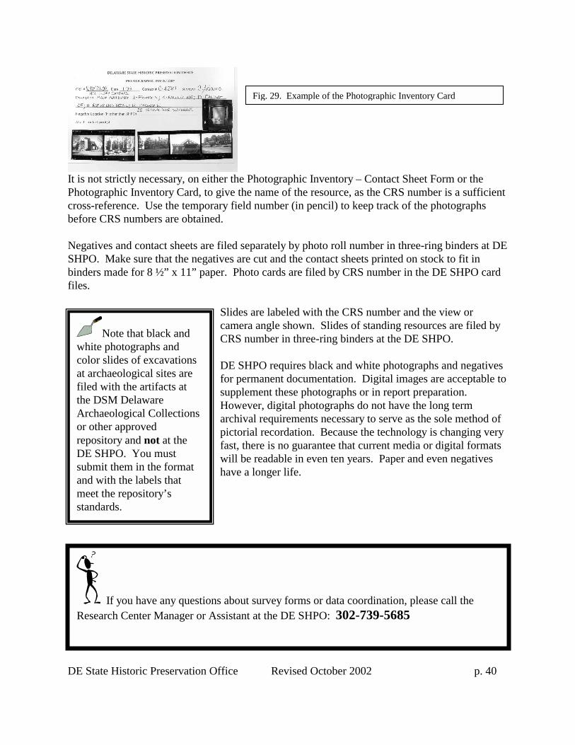
DE State Historic Preservation Office
It is not strictly necessary, on either the Photographic Inventory Card, to give thcross-reference. Use the temporary fieldbefore CRS numbers are obtained. Negatives and contact sheets are filed seSHPO. Make sure that the negatives arebinders made for 8 ½” x 11” paper. Phofiles.
SlidescamerCRS n DE SHfor pesuppleHowearchivpictorifast, thwill behave a
d
Note that black and white photographs and color slides of excavations at archaeological sites are filed with the artifacts at the DSM Delaware Archaeological Collections or other approved repository and not at the DE SHPO. You must submit them in the format and with the labels that meet the repository’s standards.
If you have any questions aboutResearch Center Manager or Assistan
Fig. 29. Example of the Photographic Inventory Car
Revised October 2002 p. 40
Photographic Inventory – Contact Sheet Form or the e name of the resource, as the CRS number is a sufficient number (in pencil) to keep track of the photographs
parately by photo roll number in three-ring binders at DE cut and the contact sheets printed on stock to fit in to cards are filed by CRS number in the DE SHPO card
are labeled with the CRS number and the view or a angle shown. Slides of standing resources are filed by umber in three-ring binders at the DE SHPO.
PO requires black and white photographs and negatives rmanent documentation. Digital images are acceptable to ment these photographs or in report preparation. ver, digital photographs do not have the long term al requirements necessary to serve as the sole method of al recordation. Because the technology is changing very ere is no guarantee that current media or digital formats readable in even ten years. Paper and even negatives longer life.
survey forms or data coordination, please call the t at the DE SHPO: 302-739-5685