investigating fire ecology - national park service activities...how has the local ponderosa pine...
TRANSCRIPT

Pre-Field Trip Lessons
1. Fire History of Ponderosa Pine Ecosystems...............................49-71❅ Student newspaper.............................................................55-62❅ Student vocabulary.............................................................63-71
2. Why Do Forests Burn? Exploring Fire Behavior.........................73-82
3. Wildfire and Native Plants: Using a Key to Identify Trees..........83-96
4. Measuring the Earth from the Ground Up.................................97-103
5. Preparing for the Field Trip: Field Journals and Photo Collages.................................................................105-124
Investigating Fire Ecology

iii

49
JEMEZ M O U N TAINS EXPLORER G UIDES
LESSONPLAN
Pre-Visit
FIRE HISTO RY OF PONDEROSA PINE ECOSYSTEMS
FOCUS QUESTIONS:Why do foresters and ecologists think many ponderosa pine forests are unhealthy?
What role does fire play in the ponderosa pine ecosystem?
OVERVIEW OF LESSON: This lesson provides students with the basic knowledgeand vocabulary they need to begin their study of fire ecology in ponderosa pineforests. Students can use a variety of source materials to learn about how forests, andthe fires that burn through them, have changed over the last century.Studentswillread background material in a fire ecology newspaper, and can watch a presentationabout fire from the internet. An evaluation will allow teachers determine if studentshave the background knowledge to continue with the lesson sequence.
SUGGESTED TIME ALLOWANCE: Class Time: 2 hours
LOCATION: Classroom
SUBJECT AREAS: Science, Math, Technology
STUDENT OBJECTIVESStudentswill: Identify the basic components of the ponderosa pine ecosystem Understand how current forestsdiffer from forests of 100 years ago Learn the importance of fire to the balance within the ecosystem
VOCABULARY Crown fire Cambium Fire behavior Tree rings Surface fire Fire suppression
M ATERIALS Field journals Pencils Flip chart paper/blackboard Pre- and Post evaluation activity sheets Investigating Fire Ecology newspaper

50
LESSONPLAN
INVESTIGATING FIRE ECOLOGY IN PONDEROSA PINE FORESTS
Pre-
Visit
PROCEDURES
Pre- and Post-evaluation
Distribute the pre- and post-evaluation activity sheets. Remind students that this is nota graded test, but rather a measure of success for the lesson. Each student willretake the test at the end of the lesson.
1. As a class, have students brainstorm a list of what makes a healthy forestand what makes an unhealthy forest.
2. Divide students in groups of three or four, assigning each group the following ques-tions:
a. When wildfire strikes, why do some trees live and others die?
b. What happened in the late 1800 s that contributed to crowded forest conditions?
c. How has the local ponderosa pine forest ecosystem changed over the past century?
d. What differences do you think you will observe in a thinned plot and an unthinned plot?
3. Hand-out copies of the enclosed newspaper and vocabulary lists to each student.Have each student read the newspaper and answer their question as a group.
4. Resume whole class discussion. Have each group do a presentation on theiranswers to their question.
5. Invite a local ecologist to the classroom to discuss ponderosa pine fire ecology orview the presentation on fire ecology at: www.volunteertaskforce.org/lessons

51
JEMEZ M O U N TAINS EXPLORER G UIDES
STUDENTSHEET
Name________________________________________________________________
Fire History of Ponderosa Pine EcosystemsAssessment Questions
1. What information can be determined about tree growth from analyzingtree rings?
2. The only part of a tree that is actually alive is a very thin layer directly under thebark called the _____________________.
3. During good growing conditions, annual growth tree rings will be_______________.
4. In years of less favorable growing conditions, annual growth tree rings will be____________________.
5. Ponderosa pine forests have evolved over thousands of years. What are some ofthe adaptations this tree has developed which have helped its survival rate?
6. Before European settlement, widespread fires occurred every 2-15 years. If youwere an early explorer how would you describe the condition of the forests in theearly 1800 s?
7. What is fire suppression and how has it contributed to the fuel buildup on the forestfloor?

52
STUDENTSHEET
INVESTIGATING FIRE ECOLOGY IN PONDEROSA PINE FORESTS
8. Today s forests are often characterized by dense dog-hair thickets of young pine.Explain what this term means.
9. The three things that affect fire behavior are:1._____________2._____________3._____________
10. Many ponderosa pine forests today have become dense, unhealthy thickets ofyoung trees and needle litter mats. What triggered this change in the forest struc-ture? When did this happen? How has this change contributed to destructive for-est fires?
11. New Mexico has the second highest incidence of lightning strikes. What state isthe highest?
12. What are some ways we can restore the ponderosa pine forests of the region to amore natural state?
53
JEMEZ M O U N TAINS EXPLORER G UIDES
TEACHERMASTER
FIRE HISTO RY O F PONDEROSA PINE ECOSYSTEMSASSESSMENT TEACHER M ASTER SHEET
1. What information can be determined about tree growth from analyzing tree rings?
Tree rings can tell how old a tree is and the story of its growth. Widely spaced ringsindicate favorable climate conditions when the tree grew much in a year. Closelypacked rings indicate drought conditions or increased competition with other vegeta-tion.
2. The only part of a tree that is actually alive is a very thin layer directly under thebark called the cambium.
3. During good growing conditions, annual growth tree rings will be wide apart.
4. In years of less favorable growing conditions, annual growth tree rings will be closetogether.
5. Ponderosa pine forests have evolved over thousands of years. What are some ofthe adaptations this tree has developed which have helped its survival rate?
Thick bark protects the cambium from low intensity fires.Lower branches of ponderosa pine are shed to prevent small fires from reaching theneedles. This is called self-pruning.
6. Before European settlement, widespread fires occurred every 2-15 years in thisarea. If you were an early explorer how would you describe the condition of theforests in the early 1800 s?
Forests were open and park-like. Ponderosa pines were widely spaced at a density ofbetween 50 and 150 trees per acre. The ground was covered with tall grasses andmany species of wildflowers.
7. What is fire suppression and how has it contributed to the fuel buildup on the forestfloor?
Fire suppression is the attempt to extinguish all fires as quickly as possible beforethey have a chance to spread. Because downed and dead trees, needles and leaves,and other forest litter was not periodically burned, the elimination of fire from ecosys-tems has resulted in a huge increase in the fuel available to fires on the forest floor.
54
TEACHERMASTER
INVESTIGATING FIRE ECOLOGY IN PONDEROSA PINE FORESTS
8. Today s forests are often characterized by dense dog-hair thickets of young pine.Explain what this term means.
Dog hair thickets are stands of small-diameter pines with densities of hundreds oreven thousands of trees per acre.
9. The three things that affect fire behavior are:
1. fuel2. weather3. topography
10. Many ponderosa pine forests today have become dense, unhealthy thickets ofyoung trees and needle litter mats. What triggered this change in the forest struc-ture? When did this happen? How has this change contributed to destructive for-est fires?
Fire suppression played a role in the fuel buildup. Also, grazing patterns in the late19th and early 20th centuries contributed through large numbers of grazing livestockeating the grassy fuels that once carried low-intensity wildfires through the forest.Livestock grazing patterns changed around 1880 and fire suppression became a fac-tor in about 1910.
11. New Mexico has the second highest incidence of lightning strikes. What state isthe highest?
Florida
12. What are some ways we can restore the ponderosa pine forests of the region to amore natural state?
Forests can be mechanically thinned. Once the forest is in a condition that reducesthe threat of crown fire, prescribed fires can be introduced.

Fire Ecology In Ponderosa Pine Forests of the Jemez Mountains
verydifferent ponderosa pine forests than thatfound in the Southwest today. Photos showthese forests as extensive grasslands dottedwith small clusters of ponderosa pines. Insome scenes the grasses are two or eventhree-feet high; the orange-barked trees reach200 feet into the sky. These forests had anopen forest structure with individual trees orsmall clumps of trees spaced widely apart. Theforest held between 50 and 150 trees per acre.Today the forests have far many more trees.
Fire s Place in Ponderosa Pine Forests
Hills covered with ponderosa pine forestare the reason many of us choose to livein the mountains of the Southwest. Formillennia, these forests have been main-tained by frequent, low-intensity surfacefires. But many of the forests that we loveare unhealthy, overgrown, and ripe fora devastating crown fire. Between 1996and 2003, 40,704 wildfires burned3,152,770 acres of forest in New Mexicoand Arizona, enough burned forest tocover the entire state of Connecticut.
By living through the Cerro Grande fire,its aftermath, and the long process ofrecovery of the forest ecosystem, those ofus who live in Los Alamos have a vastpool of knowledge that should be sharedwith other fire-affected communitiesaround the West. Hundreds of towns and cities within ponderosa pine forestsexperience the same pre-fire conditionsthat existed here and, unfortunately, someof these communities will experience wild-fire.
Everyone who lives in or near ponderosapine forests needs to know the role thatfire plays in the ecosystem. Studying fireecology will help you understand howponderosa pine forests are managed andwhy it is important to maintain healthyforests. It will give you the knowledge thatwhen used properly, prescribed fire is anessential management tool to keepforests in good condition.
Understanding fire ecology can help youmake your home so that it can be defend-ed against a wildfire. To live in ponderosapine forests, we must accept fire as partof our environment and manage our landsand build our homes accordingly.W ritten by the Volunteer Task Force
What s Inside qPonderosa Pine Basics............................2
Factors of Fire Behavior ..........................3
Is This Forest Healthy? ............................4
Why are the Trees Dead?........................4
Plant Identification & Succession ............5
Using GPS................................................5
Crown Fires Strike the Nation ..................6
Forest Recovery after a Crown Fire ........7Creating Defensible Space.......................8
Craig Martin
Cerro Grande. Rodeo-Chediski. MissionaryRidge. Aspen. Since May 2000 raging wild-fires have burned through immenseexpanses of forests in New Mexico,Arizona, and Colorado. Along with dozensof smaller fires, these well-known exam-ples burned mostly through ponderosapine forest. Each burned as a crown fire,which is a devastating wave of flame thatcan reach 200-feet or more in height.
The ponderosa pine ecosystem-a uniquecollection of plants and animals centeredon this stately pine species-is widespreadthroughout western North America, andparticularly in the Southwest. Fire hasalways been a part of the ponderosa pineecosystem, but the fires of the first yearsof the 21st century were radically differentthen fires of the past. Small, low-intensityfires that stayed low to the ground havebeen replaced by huge crown fires.
The forest itself is very much changed.Historic photographs from the late 1800s show
Fire climbs from the forest floor into the treecanopy creating a raging crown fire.
Forests of the late 1800 s(left) were muchmore open and grassy than the densely crowd-ed forests found in many places today (right).
Fire in the Pines
We came to a glorious forest of loftypines, through which we have traveledten miles. The country was beautifullyundulating; and although we usuallyassociate the idea of barrenness withpine regions that was not so in thissense: every foot being covered withfinest grass and beautifully grassy
glades extending in every direction Theforest was perfectly open and unencum-bered with brush wood so that traveling
was excellent. Edward Beale, Railroad surveyor
Describing the forest when he passedthrough Arizona in 1858
55

Ponderosa Pine BasicsPonderosa pine (Pinus ponderosa) is themost common and widespread pine inNorth America. It grows from the drymountains of central Mexico north to theRocky Mountains of Canada, and fromNebraska to the Pacific Ocean. Thelargest ponderosa forests are found innorthern New Mexico and along theMogollon Rim in central Arizona. In theSouthwest, ponderosa pines grow from
about 6,000 8,500 feet inelevation. Asthe climatewarmed at theend of the lastice age, pon-derosa forestsdeveloped inthe southwestabout 8,000 to9,000 yearsago. The pon-derosa grows in dry climates
and is found in locationsthat receive as little as 7inches of rain per year.
The variety of ponderosa pinein the Southwest usually hasneedles in bundles of 3. Theneedles are 4-8 inches long,the longest of any conifer (cone-bearing tree) inthe region. On young trees, the bark is grey orblack. Once a ponderosa pine reaches about75 years old, the bark turns orange and cracksinto ovals that look likegiant lizard scales. Whenwarmed in the sunlight,the orange bark smellslikevanilla! The cones areround and heavy,withallthe scales tipped with asharp point. The seeds inthe cones are an impor-tant food source for all seed-eating animals inthe forest, particularly squirrels. Depending onlocal conditions, a ponderosa pine can grow tobe 150 feet tall and up to 4 feet in diameter. Thetree can live 400 to 500 years.
Ponderosa pine is a fire-adapted species.These trees have bark up to 4 inches thick toprotect the tender growing tissue beneath.Ponderosas have long needles that help protectthe growing branch tips against heat from a fire.As they grow tall, these trees lose their lowerbranches in a process called self-pruning. Thisincreases the chance of a tree to survive a sur-facefirebytaking away the fuel a fire could burnso that the flames cant reach into the crown ofthetree. The root system is deep under theground, offering the roots protection from fire.
Ponderosa Pine Fire Ecology
Fire is a keystone ecological process inponderosa pine forests of the Southwest.Fire was a major factor in shaping theappearance and characteristics of theseforests. Fire also serves to maintain theforests and keep them functioning as ahealthy ecosystem.
Ecologists canlearn muchabout the his-tory of an indi-vidual tree oran entire for-est by study-ing tree rings.As a tree grows, it adds rings of cells tothe outside of the trunk. Each year, a lightring of spring cells is added before a dark-er ring of fall cells. By counting either thelight or dark rings, anyone can estimatethe age of a tree.
A low intensity surface fire that burnsmostly grasses can damage a ponderosapine without killing the tree. During a smallfire, flames can wrap around the base of atree trunk, eat away the bark, and damagethe cambium, the growing layer of cells ofthe tree. Just like with an injury to humanskin, scar tissue forms over the wound.That section of the tree trunk may nevergrow again. The shape of the tree at thebase changes from a circle to a C. Theresult is called a cat-face scar. In the treerings, the scar tissue remains as a darkline that interrupts the normal pattern.
By studying tree rings and fire scars, ecol-ogists have found that prior to 1890, pon-derosa pine forests had the highest firefrequency of all forest types found in theJemez Mountains. Frequent, low-intensitysurface fires burned through the grassyunderstory of these forests about every 7-10 years. These fires, mostly caused bylightning, kept the forest open by thinningout some of the seedlings. These firesalso recycled important nutrients. Treerings tell a similar story in other parts ofthe Southwest such as along the MogollonRim in Arizona, near Flagstaff, and in thepine forests of southern Colorado.
Then around 1890, throughout theSouthwest the fires just stopped. This wasdue to the combined effects of overgraz-ing by livestock, fire suppression, logging,and the highly variable southwestern cli-mate. Grazing animals, especially sheep,ate the grass that once carried small firesthrough the forest.
Starting around 1910, an effort was made toput out all fires that started in the forest.Lumber companies took many of the oldponderosa pines from the forests, allowingmore seedlings to sprout in the sunlight.Also, periods with large amounts of rain andsnow allowed more trees to grow. Withoutthe low-intensity surfaces fires, forestsbecame much denser. Some of our pon-derosa pine forests now have several thou-sand trees per acre! These stands arecalled dog-hair thickets.
Dense stands of ponderosa pines are verydifferent places than the wide open forestsof one hundred years ago. Because the treecanopy - the upper layers of branches onthe trees - is so dense, little sunlight reach-es the forest floor. Few grasses or wildflow-ers can grow in deep shade. Also, manypine needles fall from the trees each year.In the past, fire periodically cleaned up thelayer of needles and released nutrients intothe soil. Without fire, needles can accumu-late to depths over one foot. This makes itdifficult for seeds to germinate and disruptssome nutrient cycles in the forest. The resultis a forest with very few types of plantsgrowing there. Species diversity is low in adog-hair thicket.
Trees such as Douglas fir grow well in theshade. Inside some dense stands of pines,Douglas firs grow as small and mid-sizedtrees. During a small fire, young Douglasfirs can provide a path for fire to carry fromsurface fuels into the crowns of ponderosapines. Plants that allow fire to move into thecrowns of the tallest trees are called ladderfuels.
Dense stands of trees, a thick pile of nee-dles on the forest floor, an accumulation oflogs and branches from dead trees, and lad-der fuels are the recipe for destructivecrown fires. When a hot fire reaches towardthe needles of ponderosa pines, the heatreleases flammable chemicals from the nee-dles. Trees can literally explode, and thesudden increase in heat and flame pushesthe wildfire into nearby trees. Crown firesare carried rapidly through ponderosa pineforests.
The important role that fire plays in the pon-derosa pine ecosystem is not unique, butecosystems dominated by other species ofconifer respond to fire in different ways. Insome ecosystems, such as high elevationforests in the Southwest, crown fires are thenatural way they burn. Small, patchy crownfires may burn sections of this forest every150 to 200 years. Each forest type shouldbe managed according to the specific rolefire plays there.
Distribution of ponderosa pines in the West
56

Factors of Fire BehaviorThe Fire Triangle and ForestsFire is a simple chemical reaction thatrequires three components: heat, oxygen,and fuel. Remove any of the componentsand you no longer have fire. Each compo-nent supports the others in the fire trian-gle. This is true for something as small asa burning candle or as large as a ragingwildfire.
Heat in a Wildfire: Why Fires StartWhen enough heat is applied to fuel withoxygen present, fire can start. Beforepeople came to ponderosa pine forests,the heat that started wildfires came main-ly from lightning. The number of lightningstrikes in the Southwest, particularly inthe Jemez Mountains, is higher than inany other part of the United States exceptsouthern Florida.
When people arrived in the ponderosapine forest, they used fire on the land-scapes. As a result, even more firesoccurred in the forest. Campfires some-times burned into the forest, and some-times people lit fires to chase game ani-mals out of the forest so that it was easierto hunt. Later, fires were lit to improvegrass conditions for grazing cattle orsheep. Today, unintentional sources ofwildfire include sparks from vehicles andtrash burning.
The temperature of the air and the groundcan affect how easy it is to start a fire.High summer temperatures increase thechance of a wildfire start.
Fuel for Thought: What in the Forest Can Burn?Many parts of the forest can serve as fuelfor a fire. Forest fuels include logs, driedgrasses, pine needles, and if the fire hasenough heat, the crowns of living trees.Fuels are divided into two groups that arebased on the way they burn during a fire.
Light fuels ignite fast because they aresurrounded by oxygen in the air. Theyhave a small diameter,soittakes lessheat to start them burning. Examples of
light fuels are dried grasses, dead leaves,dead pine needles, brush, and smalltrees. Fires in light fuels spread fasterand burn cooler than fires in heavy fuels.Heavy fuels require more heat to ignite.However,after they start burning, heavyfuels gives off much heat and burn longerthan light fuels. This is due to the fact thatheavy fuels burn more slowly than lightfuels. The outside layers take longer toburn off before oxygen can reach theinner material. Examples of heavy fuelsare logs, stumps, tree branches, deepduff or decayed leaves, and other organicmaterials.
Oxygen on the WindOxygen is always present in the forest,but certain conditions can add more oxy-gen to a fire. The harder the wind blows,the faster a fire spreads. Wind not onlyprovides oxygen for the fire, but it alsoblows the heat and flames towardunburned fuel. As the unburned fuelbecomes preheated, it ignites quickly andhelps to spread the fire farther. Windextends fire rapidly into unburned areas.As the wind carries embers over long dis-tances, new fires may ignite.
Other ConsiderationsIn the forest, the supply of the three com-ponents can determine the severity of awildfire. A dense forest offers more fuel; awindy day provides a constant supply ofoxygen. How fuels ignite, flames develop,and fire spreads is called fire behavior.Fire behavior is determined by threemajor factors:n The amount and type of fuels presentn The existing weather conditionsn The elevation and slope of the area (topography)
Fuel composition, including moisturelevel, chemical makeup, and density,determines its degree of flammability.Moisture level is most important. Livetrees usually contain a great deal of mois-ture while dead logs contain very little.The moisture content and distribution ofthese fuels define how quickly a fire canspread and how intense or hot a fire maybecome. High moisture content will slowthe burning process since heat from thefire must first eliminate moisture. In addi-tion to moisture, a fuel’s chemical makeupdetermines how readily it will bum. Someplants, such as ponderosa pines, havehigh concentrations of volatile compoundsin their needles. Once exposed to flame,
these compounds, called terpenes, canburst into flame with explosive force.Finally, density of fuel beds influence itsflammability. If fuel particles are closetogether, they will bum readily. But, if fuelparticles are so close that air cannot cir-culate easily, the fuel will not burn freely.W eather conditions such as wind, temper-ature, and humidity contribute to firebehavior. Wind, a most important factor,brings a fresh supply of oxygen to the fireas well as pushes the fire toward new fuelsources.
Temperature of fuels is determined by thesurrounding air temperature since fuelsinitiallyattain their heat from the sun. Asfire burns, high heat from nearby firespreheats fuels around the perimeter ofthe fire, sometimes to the point that theyburst into flames without being touched byadvancing flames.
Humidity, the amount of water vapor inthe air,affects the moisture level of a fuel.At low humidity levels, fuels become dry,catch fire more easily, and burn morequickly than when humidity levels arehigh.
The shape of the land, which is called itstopography, plays a critical role in how awildfire burns. On flat land, fires usuallyburn more slowly than on slopes. This isbecause on slopes, heat rises from treesburning at the base of the mountain andpreheats the trees that grow above. Thistransmits heat quickly to overhangingbranches and other elevated fuels. At thesame time, radiant heat is transferredfrom the fire to other objects on theground. Convection plays a critical role inspreading fires rapidly upslope. A steepslope draws fire upward by convection,and fire spreads rapidly as convectiveheat preheats fuels upslope. In contrast,fire travels slowly on flat terrain becauseground-level fuels are only preheated byradiant heat.
Newspaper written by: Craig MartinDesigned by: Lynne Dominy57

iii
Is This Forest Healthy?Sampling the ForestA trained forester can make observationsabout a forest and determine if it ishealthy or fire prone. However, even pro-fessionals can make better decisionswhen they make quantitative rather thenqualitative observations. But howdo we measure the forest?
One measure of forest health is the densi-ty of trees within an area. Before 1880, a typical acre of ponderosa pine forest held 50 to 100 trees. Using that number as aguide, researchers today can use thenumber of trees per acre as an importantindicator of forest conditions.
W e can’t travel into the past to study for-est conditions in the 1800s. But through-out the Southwest, forest managers haveused modern techniques to backtrackthrough time and change forest conditionsto something more like those in the past.
W e can use thinned and unthinned standsof ponderosa pine to make a comparisonbetween pre-settlement and modernforests and to evaluate the health of thepresent forest. One such stand is locatedjust outside of Los Alamos in RendijaCanyon. The stand was thinned in 1996and presents a picture of an open forestmuch like those of the last centuries.
Ecologists can’t count the number of treesin an entire forest, and even an acre offorest can be too large to study. To makemeasurements easier while keeping themaccurate, ecologists use a study plot tosample the forest. A plot is a small areayou measure to estimate conditions in alarge area that is too big to study. Forexample, to find the percent of surviving
pine seedlings planted after a fire, youcouldn’t count all the dead and survivingseedlings on 600 acres. But it would bepossible to set up several one-tenth-acreplots and from what you learn to estimatethe survival rate of the whole plantedarea.
Researchers can use a plot sample tocalculate tree density. They simply countall the trees in the plot and multiply thecount by the size of the plot. For example,in a quarter-acre plot, multiply the numberof trees by four. If the plot is one-quarterof one-quarter acre, then multiply thecount by 16.
The size and age of the trees in forestscan also indicate something about foresthealth. (To standardize the diametermeasurements in the field, forestersmeasure trees about four feet above theground or at chest height. The number iscalled the DBH.) In a dog hair thicket,trees grow close together. Closely spacedtrees must compete with each other forwater, nutrients in the soil, and for sun-light. Not many trees get all they need togrow. The result is slow growth. This cancreate a forest of old trees that havesmall diameters. By drastically reducingcompetition among the crowded trees, athinning project releases a burst of growthin the remaining trees. The result is arapid increase in the size of the trees.
When ecologists measure tree diameters,they can calculate the tree basal area of astand. Tree basal area is the area of theplot covered by tree trunks. In unthinnedplots, there are lots of small diametertrees; in a thinned plot, there are fewerbut bigger trees. The total basal area of
two plots such plots can be surprisingly simi-lar.
The two pieces of information about theunderstory show the effects of the thickaccumulation of pine needles when fire isremoved from the system, and the effects ofa closed canopy that reduces the amount ofsunlight on the forest floor. Both the per centcover and the biodiversity are increasedwhen a forest is thinned and the canopyopened up. Biodiversity is a strong indicatorof forest health.
W H Y ARE SO MANY TREES DEAD?
Drought hit the Bandelier area with avengeance in 2002.Ponderosa and piæonpines are showing signsof significant mortalitybrought on by the lackof rain and the corre-sponding invasion ofpine beetles thatattacked the weakenedtrees. 95% of the treesacross some parts ofthe Pajarito Plateaudied by the summer of2003. Because of theincreased fire dangerposed specifically bythe ponderosas,Bandelier Fire Crewshave been working tobuild fire breaks and toremove bug-killed treesin critical areas. Many ofthe trees were piled andburned to destroy thebeetle larvae and diminish the number that willbecome adults.
Safety in a Burned Area
Many dangers are found in a burned area for years after a wildfire passes through. Visitors to burned areasshould always remember to be watchful for hazards: Always look up, look down, look all around.
Hazard Trees: Hazard trees are trees that could fall over and injure someone in the area. Hazard trees canbe ones that are leaning, have fallen part way down and are resting on another tree. They can be treesobviously weakened by the fire at the base of the trunk, have vertical splits or cracks, broken or looselimbs, or a loosened and damaged root system. As you walk through a burned area, always try to identifyhazard trees and to avoid walking near them. Stay out of burned areas on windy days.
Root Holes: A wildfire can burn the roots of trees and stumps-even though they are underground. When thewood is burned, it leaves a hole in the ground. These holes are often covered with soil and not visible onthe surface. If you step on a root hole, the ground above can collapse. Always watch for root holes whentraveling in a burned area.
Rolling Objects: After a wildfire there is little vegetation to protect soil from erosion. As soil is washed fromaround the base of objects on steep slopes, rocks and logs can roll downhill. When walking on slopes,
always watch above for rolling objects.
Flash Floods: Because there is no vegetationleft to absorb or slow it down, water flowing down hillsides increases after wildfire. When a storm threatens,stay out of canyon bottoms. Remember that a storm that is miles away can send a wall of water downstream where it is not raining.
58

Plant Identification & Succession
To survive a fire, a plant must be able toinsulate itself from the heat of the flames.Bark thickness is one of the most impor-tant factors determining fire resistance oftrees. Ponderosa pine, long leaf pine,slash pine, burr oak and giant sequoia areexamples of trees with thick bark that actas insulation. Small woody plants andshrubs, which normally have thin bark,tend to use the soil as an insulating layerto protect their roots. Individual plantsresist being killed in fires by producingnew growth (shoots) from undergroundorgans or roots. Some plants protect theirbuds as an adaptive strategy to survive afire. Buds can be protected by layers ofsucculent foliage. The buds of the longleafpine are protected by a thick cluster ofneedles. Some plants even protect theirbuds by locating them within the mainstem and roots.
Retention of seeds by plants until a firedoes occur and stimulation of seed dis-persal by fire are other examples of fireadaptation. A number of pine speciesaround the world, said to be serotinous,have cones that open only as the result ofheat from a fire. Their cones are heldclosed by a resin that is sensitive to andopens in high temperatures generated bywildland fires. Serotinous cones will notopen to release the seeds until the criticaltemperature is reached. Some cones,such as those on giant sequoia trees, will
not open unless burned by fire. Today,people are beginning to recognize thatfire is not always destructive. Fire ismerely a means of change in ecosys-tems.
A hot wildfire burns all the seeds availableon the ground and kills most or all theseeds that lie buried in the forest soil.W ildfire also takes away the sources ofnew seeds that could regrow both thecanopy and understory vegetation.
Yet, a burned forest doesn’t stay totallybarren for very long. The first plants toappear in a burned area are the plantsthat easily sprout from roots. The roots ofsome plants that grow beneath four toeight inches of soil are insulated from theheat of a wildfire. When a fire removesthe leaves of these plants, a chemical sig-nal stimulates the growth of shoots fromthe roots. These shoots can reach thesurface only a few weeks after a fire. Inponderosa pine forests, Gambel and
other oaks sprout in this way. Aspens,too, grow from the roots of fire-killedtrees.
W ithin a few weeks of a fire, seeds fromnearby, unburned stands of forest canblow into the burned area on the wind, orcan hitchhike in the fur of mammals.Grasses and some kinds of wildflowersthat were found in the forest before thefirestart to grow. Other species that thriveon bare soil can go wild.A year after a fire in ponderosa pineforests, red-stemmed goosefoot plantscan grow by the millions.
To survive a wildland fire, most plants have adaptive traits or abilities that allow them to reproduceor regenerate after the fire. Such plants are called phyrophytes, literally meaning fire-treated plants.
Aspen shoots grow in the Cerro Grande burnarea the year after the fire. These fast growingtrees need fires to open the canopy so thattheir seeds receive enough light to grow.
Global Positioning System
Locating a sampling plot on a map was once a difficult process. Since the invention of the Global Positioning System (GPS),finding exact locations is no more difficult than using the remote control for a television. The system consists of the satellitecomponent and the receiver component. Under the right conditions, handheld GPS receivers are accurate within 10 feet.
The GPS is a system of 24 satellites. The satellites:n orbit at 11,000 miles above the earth’s surfacen take about 12 hours to complete one orbitn are spaced so that at least 4 are always in view of an observer at any point on Earthn contain a controlling computer and communicate with the Earth via radion are powered by solar cells n use atomic clocks to generate and transmit time signals
A GPS receiver locks onto the timing signals to determine the receiver’s latitude, longitude, andelevation. Scientists use the GPS in a wide variety of studies. The data can be used to mark thelocation of a study area on a map, or to re-locate a plot on the ground.
GPS readings need to be precise. This requires recording latitude and longitude in degrees, minutes, seconds, and tenths ofseconds.n Each degree of latitude is about 70 miles. n Dividing a degree into 60 minutes makes each minute about 1.1 miles.n Dividing a minute into 60 seconds makes each second about 90 feet.n Dividing a second into tenths permits the user to be accurate within 9 feet.
59

An Arizona Example
Rodeo-Chediski FireLocation: Fort Apache IndianReservation and Apache-SitgreavesNational Forest,June-July 2002
On June 18, 2002 a human-caused firespread north from near the rodeogrounds on the White Mountain ApacheReservation. Wind pushed the fire northinto the world’s largest stand of pon-derosa pine along the 50-mile MogollonRim in central Arizona. Two days later,alost hiker tried to signal a helicopter bylighting a fire. Winds quickly pushed thefire up Chediski Peak, which was 15miles from the growing Rodeo Fire.
Both fires found abundant fuel in theovergrown stands of ponderosa pine,and plenty of oxygen in the strong, drysummer winds. Towns to the north wereevacuated. By June 22, the fire reachedthe top of the rim and raced into thetowns of Heber and Overgaard, destroy-ing more than 400 homes.
On June 23, the two fires combined intoone huge fire called by many TheMonster, the largest recorded fire in thehistory of the Southwest. About 30,000people were evacuated from nearbytowns. By the time the fire was con-tained in July, it had burned almost500,000 acres.
Crown Fires Strike the Nation
On May 10, 2000, the Cerro Grande Fire, pushed by high winds up to 54 mph, sweptthrough Los Alamos, New Mexico. In its path, the wildfire burned 235 structures and left 400families homeless. Before the fire was out more than two months later, it had charred more
than 42,000 acres of forest in the Jemez Mountains.
The Cerro Grande Fire May-July 2000Location: Bandelier National Monument& Santa Fe National Forest
On May 7, 2000, what had started as aprescribed fire jumped the fire lines nearthe summit of Cerro Grande peak androared into the ponderosa pine forestbelow. Winds up to40 miles per hourpushed the firetoward the city ofLos Alamos. Whenthe fire front movedone mile in a matter of minutes, the part of Los Alamosclosest to the flames was evacuated.
Before the fire, scientists studied treerings and fire scars from trees in the pon-derosa pine forests near Los Alamos.They discovered that before 1880 fires inthe forest had burned through the areaevery five to ten years. By 1910 the firesstopped. Looking for a cause of this sud-den end to fires, researchers found thatbetween 1880 and 1910 huge flocks ofsheep came to graze in the forests.Starting around 1910 all fires in the areawere put out as quickly as possible.Sheep removed the grassy fuels thatspread small fires through the ponderosapine forest and any fire that did start wasput out. With no fire to keep the forestfuels -pine needles, dead trees, andcrowds of small live trees-in check, fuelsin the forest built up to dangerous levels.
Afterits initial run, the fire grew slowlythrough ponderosa pine woods chokedwith small trees over the next two days.
Just after noon on May 10, wind gusts upto 60 miles per hour pushed the fire intothe crowns of the trees on the edge of LosAlamos Canyon. As the flames raced fromtree to tree, the wind carried burning firebrands across the canyon and into the city.W ithin minutes, an evacuation order wasgiven to the 12,000 people living in LosAlamos. The residents hurriedly packed afew belongings and drove slowly out oftown. By 4 PM, the streets of Los Alamoswere empty.
In the forest, wind gusts fed oxygen to thefire and the crown fire raced two miles inone hour. In the town, some of the homesnearest the forest caught fire. Firemenfrom all over New Mexico fought theflames in the city. The high winds contin-ued into the night, helping spread theflames from house to house.
In the forest, the fire spread to two direc-tions. One branch of the fire reachedtoward White Rock, a nearby town wheremany Los Alamos residents had foundshelter. At 1 AM on May 11, the order wasgiven to evacuate White Rock. Many LosAlamos residents were evacuated a sec-ond time.
The next morning, parts of Los Alamos stillburned. The homes of 400 families werelost. The fire in the forest had moved fourmiles during the night. Another day ofstrong winds moved the fire through theSanta Fe National Forest to Santa ClaraPueblo lands.
Dry conditions and plenty of fuel kept thefire burning on a smaller scale until July.By then the fire had burned 42,000 acres.
The mark of a true community is when disaster strikes and everyone from schoolstudents to senior citizens pull together to make recovery happen. From tree plantingto seeding & mulching, rebuilding trails to learning in classrooms about fire effects,
the citizens of Los Alamos worked together to begin the restoration of their mountain.Craig Martin, Los Alamos County Open Space Specialist
An Early Crown Fire in the Jemez Mountains
La Mesa Fire June 1977Location: Santa Fe National Forestand Bandelier National Monument
A few minutes before 4 PM on June17, 1977 the St. Peters Dome lookoutranger reported a thin column ofsmoke on Mesa del Rito. By 4:30 PM,flames and heavy smoke covered thecountryside. The human-caused firestarted in a slash pile near a dirt road.
In less than two hours, the fire grew to50 acres. Hot, dry, and windy condi-tions led to a rapid spread. The fireburned in heavy ponderosa pine foreston the mesas, and cinders fell on thetown of White Rock eight miles down-wind. For seven days, the fire burnedthrough pine forest. On the night ofJune 23, a heavy thunderstorm dousedmost of the fire and it was declaredcontrolled. The fire burned about 15,300 acres.
60

iii
Forest Recovery After a Crown Fire
Often all vegetation is killed and no tree leaves, conifer needles, or ground coverremain to absorb the impact of falling raindrops or to slow the flow of water across thehillsides. Beginning with the first rainstorm, forest soil begins to erode and is oftenwashed away. In mountain ranges in the Southwest, soil can take 10,000 years todevelop. Rainstorms can dump millions of gallons in a watershed in less than an hour.Such storms produce flash floods. Compared to the flow of the streams before the fire,the post-fire flows can be 1,000 times greater.
Intense heat can kill most of the seeds lying in the forest soil. But some plants, such asaspen and oaks, have underground roots deep enough to survive the fire. Withinweeks, the surviving roots send up shoots. Aspen sprouts can grow three feet high inthe weeks following a wildfire. Oak roots can send up dozens of sprouts. Also, the windand birds carry seeds from areas outside the burn and drop them on the ash-coveredsoil. Depending on the climate conditions, many grass and wildflower species comeback to a burned area in the first two years.
After a wildfire, it is often a race to get living plants growing before the first rains of thesummer to help hold the soil in place. Land managers often operate emergency seed-ing projects. Because grass plants are quick-growing and have an extensive system offibrous roots, they are ideal for holding soil. Grass seeds can be scattered by hand orfrom the air with helicopters or airplanes. Because they are adapted to the conditions inthe ecosystem, native grass species are used. The seeds grow best when a layer ofstraw mulch covers them. After the Cerro Grande fire, much of the seeding andmulching was done by volunteers.
W ildfire can destroy ponderosa pine seeds in the soil. In areas of extensive crown fire,live trees that could provide new seeds may be miles away. It is important to plant pon-derosa pine seedlings to regenerate the forest and to provide a source of seeds for thefuture. Seedlings-usually no more than six-inches tall-are planted in many burnedareas. More than 200,000 seedlings have been planted on the Cerro Grande fire.
THE FLAMES AND HEAT ARE JUST THE BEGINNING OF THEDAMAGE TO AN ECOSYSTEM CAUSED BY A CROWN FIRE.
(left to right) A burned section of Rendija Canyon shows that few trees survived the heat of theCerro Grande fire in this part of the canyon; Following reseeding efforts by volunteers, the samesection in the canyon has many grasses growing the following year; Heavy flooding affected aburned area in Valle Canyon during the summer rains following the Cerro Grande fire; Volunteersreconstruct a trail damaged by the Cerro Grande fire.
Reactions to Burned Forests
The sight of a severely burned foresttouches everyone, even the most hard-ened firefighter. The forest, both beforea fire and after, evokes difference sen-sory experiences and emotions in eachof us. How does a burned forest makeyou feel? You may be surprised to findbeauty even in the blackness.
On way of expressing feelings about a burned forest is to create a work ofart or poem. David Hockney, an artistbest known for paintings, also workedwith photographs he called joiners.Joiners is a method of taking manyphotographs, or the individual parts, ofa subject and piecing the prints togeth-er to recreate the scene in a photo col-lage. Hockney combined multiple viewsof a single scene in order to explore theway people shift their gaze in manydirections as they observe something.
Quemazon Trail by Caryn Kohlrust(Mountain Elementary School
6th Grader)
Quiet is this deserted place,Unique in its own way as,
Erosion comes far and near whenMammals have left,
As many people come and go,Zillions of lizards and insects remain,
On and under rocks, with,Nothing left of their home.
Though we know theReason the fire has come, the
Amphibians andInsects might not, some of us are
Looking for what sleft of our homes.
Both the ecological and human recovery from wildfires is very slow. The com-munity of Los Alamos, with the help of thousands of people in New Mexico,
survived the Cerro Grande Fire. In their own words:
We will rebuild and rise out of the ashes. Senator Steve Stoddard,retired resident of Los Alamos
A disaster survivor is anyone affected by the Cerro Grande Fire. Losing your home,living in a damaged home, as well as having your sense of safety and well-being
compromised by the evacuation makes you a survivor. Project Recovery
61

iii
Creating Defensible SpaceCreate a FireWise Home
by Cameron Ott, Collin Delano, and Sarah Wyman
Sixth graders at Mountain Elementary School in Los Alamos have suggestedthe following ways to help prevent a wildfire from destroying your home:
1. Clean your roof and keep gutters free of debris like pine needles.
2. Move woodpiles away from your house.
3. Clear brush around your home to create at least a thirty foot defensible space.
4. Landscape with fire resistant vegetation.
5. Keep flammables, like propane tanks, 50 feet away from your house.
6. Create fuel breaks by strategically placing sidewalks, graveled paths,fish ponds, and walls.
7. Whenever possible, use fire resistant building materials such as metal roof-ing
Visit w w w.firewise.org for more information.
Living on the Edge: Defensible Space
People who live in high risk wildfire areasare faced with the growing concern that awildfire could damage or destroy their homeand property. Every year many families losetheir homes and possessions to wildfire.These losses can be minimized if home-owners take a pro-active approach to homesafety. When homeowners take the time tobecome aware of appropriate safety meas-ures and put forth the effort to implementthose measures, they often greatly improvethe ability of fire fighters to protect theirhomes, and will reduce their vulnerability tothe destructive forces of fire.
Defensible space is one of the primarydeterminants of a building’s ability to surviveawildfire. The goal of creating defensiblespace is to develop a landscape around abuilding that provides an opportunity for fire-fighters to defend it against fire. Whengrasses, brush, trees, and other commonforest fuels are removed, reduced, or modi-fied in a yard, a fire’s intensity or nearness toa structure decrease. That situation providesa space for firefighters to battle the blaze.Defensible space is not a guarantee that astructure will survive, but it often increases
the chances of protection from wildfire.
Creating a defensible space starts withlandscaping. You should remove allburnable vegetation from a distance of atleast 30 feet from your house. You mayhave to cut down trees or remove brush.Pine needles should be no more thantwo inches deep. All other dead vegeta-tion should be removed. If there aremany pine trees around the house, youshould thin the forest by removing manyof the trees. Any smaller trees or lowbranches that could act as ladder fuelsshould be taken out.
You can replace some of the vegetationaround your house with fire-resistantplants. These plants usually have a highmoisture content in the leaves thatmakes them more difficulttoburn. Treeslike maples, walnuts, and willows aregood choices. Wildflowers and grasses
can help create a more defensible space.
Houses near the edge of the forest shouldbe built with safe, resistant materials. Ametal roof and walls of stucco or adobeoffer good fire protection. Wooden decksare highly flammable and should be pro-tected with special materials.
Other actions can make a big difference.Keep the yard clean of debris. Clean theroof and gutters at least twice a year. Movepiles of firewood at least 30 feet from thehouse. Propane tanks should be used orstored away from the house.
Every family who lives in the ponderosapine ecosystem should make a defensiblespace plan.
Extension activitiesVisit a nearby ponderosa pine forest. Try to find the following features and answer the questions.
Find a tree with a cat-face scar near the base. From which direction do you think the wind was blowing during the fire?
Find a tree that has been cut with a saw. How old was the tree when it was cut? Are there any fire scars interrupting therings?
Locate a dog-hair thicket. How deep is the layer of pine needles on the forest floor? How many kinds of wildflowersdo you see growing there?
Find a tall, orange-barked ponderosa pine. How far above the ground are the first branches? What does the bark smell like?
Locate a small ponderosa pine with needles you can reach. If you break a needle in two, does it release a pleasant smell? 62

63
JEMEZ M O U N TAINS EXPLORER G UIDES
VOCABULARY
VOCABULARY O F FIRE ECOLOGY
Acre:a unit of area equal to 43,560 square feet.
Acquisition time:the time it takes a GPS receiver to acquire satellite signals anddetermine the initial position.
Adaptation:an alteration in structure or function of a plant or animal that helpsitchange over the course of successive generations in order to be better suited to liveinits environment.
Background: all objects that come from behind the subject away from the camera.
Basal area per hectare:the area of the cross-section of tree stems near their base,generally at breast height and including bark, measured over 1 ha of land.
Biodiversity:the diversity of plants, animals, and other living organisms in all theirforms and levels of organization, including genes, species, ecosystems, and the evo-lutionary and functional processes that link them.
Bole:trunk of a tree
Breast height:the standard height, 1.3m above ground level, at which the diameterof a standing tree is measured.
Camera angles:the area seen by a lens or viewfinder; or the positioning of the sub-ject in relation to the camera shot.
Cambium:the single layer of cells between the woody part of the tree and the bark.Division of these cells results in diameter growth of the tree through formation of woodcells (xylem) and inner bark (phloem).
Canopy:the forest cover of branches and foliage formed by tree crowns.
Centimeter (cm): in the metric system, a unit of length defined as 1/100 of a meter,equal to 10 millimeters or 1/10 of a decimeter.
Circumference:the distance around a circle or sphere.
Clinometer:a simple instrument for measuring vertical angles or slopes. In forestry,used to measure distance and tree heights.
Coordinate:a number used to locate a point on a number line, or either of two num-bers used to locate a point on a coordinate grid.
Combustible debris:items that catch fire and burn easily; flammable.
Commercial thinning:a silviculture treatment that thins out a thick stand of trees byremoving trees that are large enough to be sold as products such as poles or fenceposts. It is carried out to improve the health and growth rate of the remaining trees.

64
VOCABULARY
INVESTIGATING FIRE ECOLOGY IN PONDEROSA PINE FORESTS
Competing vegetation:vegetation that seeks and uses the limited commonresources (space, light, water, and nutrients) of a forest site needed by preferred treesfor survival and growth.
Competition:the struggle among individual organisms for food, water, space, etc.when the available supply is limited.
Composition:the proportion of each tree species in a stand expressed as a percent-age of the total number, basal area or volume of all tree species in the stand.
Crown fire:a fire that burns primarily in the leaves and needles of trees, spreadingfrom tree to tree above the ground.
Damaged timber:timber that has been affected by injurious agents such as wind (asin the case of blowdown), fire, insects, or disease.
Debris flow:mixture of soil, rock, wood debris and water which flows rapidly downsteep gullies; commonly initiate on slopes greater than 30.
Deciduous:perennial plants which are normally leafless for some time during theyear.
Defensible space:an area around a structure where fuels and vegetation are treat-ed, cleared, or reduced to slow the spread of wildfire towards the structure, giving fire-fighters a chance to defend the structure.
Data:information usually gathered by observation, questioning, or measurement.
Density:In plant ecology, DENSITY = (Total number of individuals)/total area).
Diameter:a line segment that passes through the center of a circle (or sphere) andhas endpoints on the circle (or sphere); also, the length of such a line segment. Inforestry, a line passing through the center of a tree.
Diameter tape: a graduated tape based on the relationship of circumference to diam-eter which provides direct measure of tree diameter when stretched around the out-side of the tree, usually at breast height.
Dichotomous key:a tool used by scientists to find the identity of a butterfly, a plant,a rock, or anything else. Dichotomous means divided in two parts. A key is used byanswering a series of yes or no questions.
D B H:Diameter breast height; the bole diameter of a tree measured outside the barkat a height of 1.3 meters.
Disturbance:a discrete event, either natural or human-induced, that causes achange in the existing condition of an ecological system.

65
JEMEZ M O U N TAINS EXPLORER G UIDES
VOCABULARY
Dominance (Dominant):the extent to which a given species predominates in a com-munity because of its size, abundance, or coverage.
Drought:a time when there is little or no precipitation such as rain or snow.
Duff:the layer of partially and fully decomposed organic materials lying below the lit-ter and immediately above the mineral soil.
Ecological balance:a state of dynamic equilibrium within a community of organismsin which genetic, species and ecosystem diversity remain relatively stable, subject togradual changes through natural succession.
Ecology:the science that studies the ways in which plants and animals live togetherin the natural environment of our planet.
Ecosystem:a functional unit consisting of all the living organisms (plants, animals,and microbes) in a given area, and all the non-living physical and chemical factors oftheir environment, linked together through nutrient, cycling and energy flow. Anecosystem can be of any size- a log, pond, field, forest, or the earth s biospherebut it always functions as a whole unit. Ecosystems are commonly described accord-ing to the major type of vegetation, for example, forest ecosystem, old-growth ecosys-tem, or range ecosystem.
Ecotone:a transition area between two adjacent ecological communities usuallyexhibiting competition between organisms.
Elevation: the height above sea level.
Endangered species:a species in danger of extinction.
Estimate:a ballpark answer, a number close to another number, a calculation of aclose, rather than exact, answer.
Evergreen: never entirely without green foliage, leaves persisting until a new set hasappeared.
Fire: a self-sustaining chemical reaction that can release energy in the form of lightand heat.
Fire behavior: the manner in which a fire reacts to fuel, weather and topography;common terms used to describe fire behavior include smoldering, creeping, running,spotting, torching and crowning.
Fire danger: an assessment of both fixed and variable factors of the fire environment,which determine the ease of ignition, rate of spread, difficulty of control, and fireimpact.
Fire hazard:the potential fire behavior for a fuel type, regardless of the fuel type sweather-influenced fuel moisture content or its resistance to fireguard construction.Assessment is based on physical fuel characteristics, such as fuel
65

66
VOCABULARY
INVESTIGATING FIRE ECOLOGY IN PONDEROSA PINE FORESTS
arrangement, fuel load, condition of herbaceous vegetation, and presence of elevatedfuels.
Fire impact(s): the immediately evident effect of fire on the ecosystem in terms ofbiophysical alterations (e.g., crown scorch, mineral soil erosion, depth of burn, fuelconsumption).
Fire history:the chronological record of the occurrence of fire in an ecosystem.
Fire intensity:a general term relating to the heat energy released in a fire.
Fire-resistant species:species with morphological characteristics that give it a lowerprobability of being injured or killed by fire than a fire-sensitive species, which has arelatively high probability of being injured or killed by fire.
Fire scars:scar tissue that develops if a tree or shrub is burned by a fire but is notkilled. The fire leaves a record of that particular burn on the plant. Scientists canexamine fire scars and determine when and how many fires occurred during theplant s lifetime.
Fire suppression:all activities concerned with controlling and extinguishing a fire fol-lowing its detection. Synonymous with fire control.
Fire triangle:the three components that are necessary for a fire to take place and forthe fire to keep burning; the ingredients are heat, fuel, and oxygen.
Firewise landscaping:management of vegetation that removes flammable fuels fromaround a structure to reduce exposure to radiant heat. The flammable fuels may bereplaced with green lawn, gardens, certain-individually spaced green, ornamentalshrubs, individually spaced and pruned trees, decorative stone or other non-flamma-ble or flame-resistant materials.
Food chain:a chain of organisms, linked together because each is food for the nextin line. Energy passes from one level to next. All the food chains in an ecosystem areconnected together in a complex food web.
Forest fire:an uncontained and freely spreading combustion that consumes the natu-ral fuels of a forest, such as duff,litter, grass, dead branch wood, snags, logs,stumps, weeds, brush, foliage, and, to a limited degree, green trees.
Forest management plan:a general plan for the management of a forest area, usu-ally for a full ration cycle, including the objectives, prescribed management, activitiesand standards to be employed to achieve specified goals. Commonly supported withmore detailed development plans.
Forest health: a forest condition that is naturally resilient to damage; characterizedby biodiversity, it contains sustained habitat for timber, fish, wildlife, and humans, andmeets present and future resource management objectives.

67
JEMEZ M O U N TAINS EXPLORER G UIDES
VOCABULARY
Formula:a general rule for finding the value of something. A formula is usually writtenas an equation with variables representing unknown quantities.
Fuel: all the dead and living material that will burn. This includes grasses, deadbranches and pine needles on the ground, as well as standing live and dead trees.Also included are minerals near the surface, such as coal that will burn during a fire,and human-built structures.
Fuel load:the amount of combustible material (living and dead plants and trees) thatis found in an area.
Global Positioning System (GPS):a global navigation system based on 24 or moresatellites orbiting the earth at an altitude of 12,000 miles and providing very precise,worldwide positioning and navigation information 24 hours a day, in any weather.
GPS coordinates:a set of numbers that describes your location on or above theearth. Coordinates are typically based on latitude/longitude lines of reference or aglobal/regional grid projection.
GPS distance: the length (in feet, meters, miles, etc.) between two waypoints orfrom your current position to a destination waypoint. This length can be measured instraight-line (rhumb line) or great-circle (over the earth) terms.
GPS receiver: consists of the circuitry necessary to receive the signal from GPSsatellites and uses the information to calculation the user s position on the earth.
Ground fire: fire that burns in the organic material in the litter layer, mostly by smol-dering combustion. Fires in duff, peat, dead moss and lichens, and downed wood aretypically ground fires.
Habitat:the place where an organism lives and/or the conditions of that environmentincluding the soil, vegetation, water, and food.
Hazard tree:a live or dead tree whose trunk, root system or branches have deterio-rated or been damaged to such an extent as to be a potential danger to human safe-ty.
Heat:necessary ingredient for fire to start; can be supplied by lightning or humansources.
Hectare: an area of 10,000 square meters, or 100 x 100 meters. There are 100hectares in a square kilometer.
Human impact or influence: a disturbance or change in ecosystem composition,structure or function caused by humans.
Increment borer: a tool used to extract a core of wood from a living tree for the pur-pose of studying the annual growth rings of the tree.
67

68
VOCABULARY
INVESTIGATING FIRE ECOLOGY IN PONDEROSA PINE FORESTS
Invasive species:species that can move into an area and become dominant numeri-cally or in terms of cover, resource use, or other ecological impacts.
Joiner photographs:multiple frame images shot from different angles and laterjoined together to recreate the scene or person.
Juvenile spacing: a silvicultural treatment to reduce the number of trees in youngstands, often carried out before the stems removed are large enough to be used orsold as a forest product. Preventsstagnation and improves growing conditions for theremaining crop trees so that at final harvest the end-product quality and value isincreased. Also called pre-commerical thinning.
Keystone species:a species that plays an important ecological role in determiningthe overall structure and dynamic relationships within a biotic community. A keystonespecies presence is essential to the integrity and stability of a particular ecosystem.
Ladder fuels:fuels that provide vertical continuity between the surface fuels andcrown fuels in a forest stand, thus contributing to the ease of torching and crowning.
Latitude:the degree measure of an angle whose vertex is the center of the Earth andon side is a radius to the equator. Used to indicate the location of a place with refer-ence (north or south) to the equator.
Litter:the top layer of the forest floor that includes freshly fallen leaves, needles, finetwigs, bark flakes, fruits, matted dead grass and other vegetative parts that are alteredlittle by decomposition. Litter also accumulates beneath rangeland shrubs. Some sur-face feather moss and lichens are considered to be litter because their moistureresponse is similar to that of dead fine fuel.
Longitude:the degree measure of how far east or west of the prime meridian a loca-tion is on Earth: determined by the angle formed by semicircles of longitude connect-ing the North Pole and South Pole and the prime meridian.
Maximum density:the maximum allowable stand density above which stands mustbe spaced to a target density of well-spaced acceptable stems to achieve free-grow-ing status.
Meter(m):the basic unit of length in the metric system, equal to 100 centimeters, and1000 millimeters.
Monitoring:the periodic measurement or observation of selected physical and bio-logical parameters for establishing base lines and for detecting and quantifyingchanges over time.
Monitoring plot:a plot installed for measuring or calibrating actual growth of treatedstands. The objective is similar to that of research plots but usually limited to one ortwo treatments; for example, thinned versus unthinned areas. These are usually per-manent plots administered by the National Forest system, sometimes in cooperationwith Forest Management Research.

69
JEMEZ M O U N TAINS EXPLORER G UIDES
VOCABULARY
Mixed stand:a stand composed of two or more tree species.
Mortality:death or destruction of forest trees as a result of competition, disease,insect damage, drought, wind, fire and other factors (excluding harvesting).
Noxious weeds: any weed so designated by the Weed Control Regulations and iden-tified on a regional district noxious weed control list.
Old growth forest:forest which has not had significant unnatural disturbances alter-ingits content or structure since European settlement.
Organizing data:arranging and presenting data in a way that makes the data easierto understand.
Overgrazing:the practice of grazing too many ruminants on land unable to recoverits vegetation or of grazing ruminants on land not suitable for grazing because ofslope. Overgrazing exceeds the carrying capacity of a pasture.
Percent(%):per hundred, or out of a hundred. 1% means 1/100 or 0.01.
Phleom:a layer of tree tissue just inside the bark that conducts food from the leavesto the stem and roots. See Cambium
Photo collage:an artistic composition made of various materials (such as paper,cloth, or wood) glued on a picture surface.
Pioneer plants:a succession term for plants capable of invading bare sites, such asa newly exposed soil surface, and persisting there, i.e., colonizing until supplanted byinvader or other succession species.
Plant community:an assemblage of plants occurring together at any point in time,thus designating no particular ecological status.
Plant harvesting:the collection of plant life including, but not limited to, bark, berries,boughs, branches, burls, cones, conks, ferns, flowers, grasses, herbs, fungi, lichens,mosses, mushrooms, roots, sedges, shrubs, sprays and twigs.
Plot:a carefully measured area laid out for experimentation or measurement.
Prescribed fire:any fire ignited by management actions to meet specific objectives.Prior to ignition, a written, approved prescribed fire plan must exist, and NationalEnvironmental Protection Act requirements must be met.
Pre-settlement fire regime:the time from about 1500 to the mid to late 1800 s, aperiod when Native American populations had already been heavily impacted byEuropean presence and before extensive settlement by European Americans in mostparts of North America, before extensive conversion of wildlands for agricultural andother purposes, and before fires were effectively suppressed in many areas.

70
VOCABULARY
INVESTIGATING FIRE ECOLOGY IN PONDEROSA PINE FORESTS
Prime meridian:an imaginary semicircle on the Earth, connecting the North Pole andSouth Pole through Greenwich, England.
Random sample:a sample taken from a population in a way that gives all membersof the population the same chance of being selected.
Recreation:any physical or psychological revitalization through the voluntary pursuitof leisure time. Forest recreation includes the use and enjoyment of a forest or wild-land setting, including heritage landmarks, developed facilities, and other biophysicalfeatures.
Reduction: the removal of plant parts, such as branches or leaves, constitutes reduc-tion. Examples of reduction are pruning dead wood from a shrub, removing low treebranches, and mowing dead grass.
Reforestation: the natural or artificial restocking (i.e., planting, seeding) of an areawith forest trees. Also called forest regeneration.
Removal:this technique involves the elimination of entire plants, particularly treesand shrubs, from the site. Examples of removal would be the cutting down of a deadtree or the cutting out of a flammable shrub.
Replacement:Replacement is the substitution of less flammable plants for more haz-ardous vegetation. For example, removal of a dense stand of flammable shrubs andplanting an irrigated, well maintained flower bed would be a type of replacement.
Restoration:the return of an ecosystem or habitattoits original community structure,with its natural complement of species and natural functions.
Sample:a subset of a population used to represent the whole population.
Separation distance:Separation distances are measured between tree canopies(outermost branches) and not between trunks.
Spreadsheet:atable displayed by a computer program, which is used to performmathematical operations, evaluate formulas, and relate data quickly. The name comesfrom ledger worksheets for financial records. Such sheets were often taped togetherand then spread out for examination.
Serotinous:a pine cone or other seed case that requires heat from a fire to open andrelease the seed.
Snag:a standing dead tree or part of a dead tree from which at least the smallerbranches have fallen.
Soil erosion:the wearing away of the earth s surface by water, gravity, wind, and ice.

71
JEMEZ M O U N TAINS EXPLORER G UIDES
VOCABULARY
Solar cell:a device made of semiconductor materials which produce a voltage whenexposed to light.
Species:a singular or plural term for a population or series of populations of organ-isms that are capable of interbreeding freely with each other but not with members ofother species.
Stand:a group of plants of the same species, same size, and same age.
Stand density:a relative measure of the amount of stocking on a forest area. Oftendescribed in terms of stems per hectare.
Stewardship: caring for land and associated resources and passing healthy ecosys-tems to future generations.
Succession:the gradual replacement of one plant and animal community by another,as in the change from an open field to a mature forest.
Surface fire:a fire that burns leaf litter, fallen branches and other fuels located on theforest floor.
Thinning:a cutting of specific trees made in a forest stand primarily to promote treegrowth and to improve the average form of the trees that remain.
Thumbnail sketch:very quick, loose drawing.
Understory:any plants growing under the canopy formed by other plants, particularlyherbaceous and shrub vegetation.
Vegetation:plant life in general
W atershed:an area of land that collects and discharges water into a single mainstream through a series of smaller tributaries.
W ildfire: an unplanned or unwanted natural or human-caused fire or a prescribed firethat has escaped its bounds.
W ildland/Urban Interface:a popular term used to describe an area where variousstructures (most notably private homes) and other human developments meet or areintermingled with forest and other vegetative fuel types.
Zeric:having very little moisture; tolerating or adapted to dry conditions.

73
JEMEZ M O U N TAINS EXPLORER G UIDES
LESSONPLAN
Pre-Visit
W H Y DO FORESTS BURN? EXPLORING FIRE BEHAVIOR
FOCUS QUESTIONSWhy do some wildfires burn entire forests and others do not?
How do firefighters break the fire triangle to control a wildfire?
OVERVIEW OF LESSON PLAN Students will arrive at a basic knowledge of the fire triangle through four activities.They will extend this knowledge into the realm of wildland fire, identifying the keycomponents of the fire triangle in the natural world. Simple demonstrations will showstudents how forest density, slope, and weather conditions affect the nature of wild-land fire. For a fun way to study fire behavior, students can play a game of fire tag.
SUGGESTED TIME ALLOWANCE: Class Time: 3 hours
LOCATION: Classroom, school yard
SUBJECT AREAS: Science, Math, Technology
STUDENT OBJECTIVESStudentswill: Correctly identify the three parts of the fire triangle Relate parts of the fire triangle to the forest environment Evaluate the effects of slope, forest density, and wind on fire behavior Explain how firefighters attack the fire triangle to put out a wildfire
VOCABULARY Fire triangle Crown fire Fire behavior Slope Forest density
M ATERIALSThree Parts of the Fire Triangle Candle Pie pan Modeling clay Matches Tall, wide-mouth jar Scissors Field journals Pencils
The Fire Triangle in the Real World Investigating Fire Ecology newspaper Field journals Pencils

74
LESSONPLAN
INVESTIGATING FIRE ECOLOGY IN PONDEROSA PINE FORESTS
Pre-
Visit
Materials (cont.)
Fire Behavior: How, Where, And When A Fire Burns Can Affect The Fire Triangle
Kitchen matches Non-toxic modeling clay (potters clay to prevent melting) Metal trays Recycled spray bottles for water Stopwatch Thermometer Heat resistant mittens or oven hot pads Fire extinguishers Safety glasses Data sheets
Fire Tag Yellow arm bands for one quarter of the students Blue Nerf balls for one quarter of the students

75
JEMEZ M O U N TAINS EXPLORER G UIDES
LESSONPLAN
Pre-Visit
PROCEDURES
Three Parts of the Fire Triangle1. Before class, use the modeling clay to hold the candle securely in the pie pan.
2. Draw a triangle on the board or overhead. Ask students what is needed for a fire.W rite answers on the board. Then use the answers to organize the three parts ofthe Fire Triangle: heat, fuel, and oxygen. Include in the discussion the followingquestions: Burnable things surround us every day. Why aren t they on fire? Whatis the fuel in fires we are familiar with?
3. W ith a candle, demonstrate that if any of the three sides of the fire triangle is bro-ken, there is no fire.
4. Stare at the candle for a moment. Ask why it is not burning? What is missing fromthe fire triangle? (Heat)
5. Light the candle. Place the jar over the candle. Wait until the candle goes out. Askwhy the candle is no longer burning. What is missing from the fire triangle? (Oxygen)
6. Light the candle again. Use scissors to cut the wick. What is missing from the firetriangle? (Fuel)
The Fire Triangle in the Real WorldHave students read about the fire triangle in the real world in their newspaper.
Students should record in their field journal:
Three sources of heat for wildfires Four types of fuel for wildfires and classify each as light fuel or heavy fuel Two ways that wind increases the oxygen for a wildfire

76
LESSONPLAN
INVESTIGATING FIRE ECOLOGY IN PONDEROSA PINE FORESTS
Pre-
Visit
FIRE BEHAVIOR:HO W, WHERE & WHEN A FIRE BURNS CA N AFFECT TH E FIRE TRIANGLE
1. Prepare at least four matchstick forests. Build a forest in each tray. Create a 5 x 8base for trees (matches) from a thin layer of modeling clay by packing firmly to thepan and flattening. In the first three trays, space matches vertically approximatelyone-half inch apart. In the last tray, place about 20 matches total in well-spacedclumps to mimic historic ponderosa pine forests.
2. Do the demonstrations on a non-flammable surface in the school yard. Place onetray on a flat surface. Elevate one end of a second tray about 20 degrees to repre-sent a moderate slope in the land s topography. Elevate one end of the third trayabout 40 degrees to represent a steep slope in the land s topography. For the his-toric ponderosa forest tray, keep the tray flat or put it on a 20 degree slope.
3. Set the matchstick forests on a heat-resistant surface. If you don t have laboratoryfacilities, one really good surface to use is a trash-can lid filled with sand. Have aspray bottle and fire extinguisher nearby.
4. Explain to students that the individual matches represent trees that have flammablecrowns, like the conifers in local forests. In this demonstration, studentswillobserve how slope and tree density affect fire spread through tree crowns.
5. Discuss the type of observations students should make and record on the datasheet. Make sure students understand the topography of the forest, number ofmatches (forest density), the time to burn all the matches in seconds, the ambienttemperature, and number of unburned trees.
6. Before lighting the matches, ask students for their hypothesis about how the fireswilldiffer.
7. Light the match tips along one edge of the flat forest and observe fire behavior.Then light the match tips along the top edge of a medium-slope forest and observe.Then light the bottom row of matches on the other medium-slope forest andobserve. Finally, light the bottom row of matches on the steep forest and observeAsk for descriptions of what the students observe and interpretations in terms ofthe fire triangle. (Heat travels upward, so the matches and trees uphill from a firereceive more heat than those below and are easier to ignite.)
8. Ask students to remove whatever remains of the matches from each board. Theycan use the nail in the kit to poke the burned matches out, if necessary.

77
JEMEZ M O U N TAINS EXPLORER G UIDES
LESSONPLAN
Pre-Visit
FIREFIGHTERS A N D TH E FIRE TRIANGLE1. Review the fire triangle.2. Have students discuss ways that firefighters could use knowledge of the fire trian-gle to stop a wildfire.a. Eliminate fuelCut down and remove trees in the path of the fire (create a firebreak)Scrape away a wide band of material lying on the ground (create a fire line)b. Eliminate oxygenThrow water on the fireThrow dirt on the firec. Eliminate heat Throw water or fire retardant on the fire
3. Play Fire Tag
FIRE TA GTo start, designate one child as the spark (that starts the fire). One quarter of thegroup will be fire fighters, identified by their yellow arm bands and each equipped witha blue Nerf ball. The remaining students will be trees (or fuel, which allow the fire togrow). At the beginning, explain to the players what each of their roles will be (seebelow). Have the spark go to one end of the playing area, and align the fire fighters atthe other end. Now tell the trees to take root and grow anywhere they wish on theplaying field. They should stand with their arms held up to mimic tree branches.
The spark, or lightning, starts the game by tagging a tree. Trees may not run from thefire! Tagged trees become part of the fire and must join hands with the spark. The firemust now continue its pursuit of trees as a unit, attempting to capture trees with theirfree hands. Captured trees must join the chain of fire.
Fire can either move as a long chain, or may break into several smaller groups andtravel as spot fires. They may not travel as individuals (pairs or more only!). This dis-tinguishes them from unburned trees.
Fire fighters should be held on the sidelines until the fire has had a chance to growto 3-4 players. At this point, ask the fire fighters, Do you smell smoke? They ll be rar-ing to go, so when they yell Yes!, allow them to go put out the fire.
Firefighters must avoid fire (they, too, can become fuel for the fire and must join thefire if caught) while attempting to slow the fire s growth. They can do this in threeways:
1. Removal of fuels Firefighters may tag trees and escort them out of the game tothe sidelines. Fire fighters and trees may not be captured by fire en route!
(Adapted from A Teachers Guide to Fire Ecology in New Mexico and the Southwest, New Mexico South Central Mountains RD and D)

78
LESSONPLAN
INVESTIGATING FIRE ECOLOGY IN PONDEROSA PINE FORESTS
Pre-
Visit
2. Direct attack - Firefighters may tag fire with their blue bandanas (water). Fire unitsthat get hit with water must walk from that point on.
3. Containment Fire fighters may join hands to encircle or contain a spot fire (wetfires are the easiest to contain because they walk slowly). Contained spot firesmust go to the sidelines.
Summary of goals of players:
TREES: Stand still: you may be captured by either fire or removed to the sidelines byfirefighters.
FIRE: Tag trees and fire fighters and grow! Avoid water-wielding firefighters.
FIRE FIGHTERS: Remove trees to sidelines before they are captured by fire. Tag firewith water to slow its advance. Join hands with other fire fighters toencircle spot fires and remove them to the sidelines.
The game is over when no trees remain. Compare the number of fire players leftatthe end of the game with the number of tree players on the sidelines. Who won, thefire fighters or the fire? Point out the similarities and differences to real life.
EVALUATIONDirect students to design a matchstick forest to observe a different slope, weather,orfuel condition, or to solve a specific problem. For example, make a matchstick foreston a steep slope and then remove 12 trees from it. Find the best arrangement of 12fewer trees to reduce the risk of fire spread.
Students should be able to explain why their experiment is important, make a predic-tion of the results, and support their ideas with their knowledge of fire behavior.

79
JEMEZ M O U N TAINS EXPLORER G UIDES
STUDENTSHEET
Name________________________________________________________________
Why Do Forests Burn? Exploring the Fire TriangleAssessment Questions
Comprehensive Paragraph: What are the elements of a fire triangle and whatoccurs when one of these components is removed from the triangle?
Matching:Fire Triangle a. a fire that burns primarily in the leaves and
needles of trees, spreading from tree to treeabove the ground.
Crown Fire b. manner in which a fire reacts to fuel,weather, and topography; common terms usedto described this activity include: smoldering, creeping, running, spotting and crowning.
Fire Behavior. c. the three components that are necessary for a fire to take place and for the fire to keep burning
True or False:1. Trees, flame and weather are the three components of the fire triangle when refer-ring to wildland fires..
True or False
2. Throwing water or dirt on a fire eliminates the fuels, thus stopping the growth of afire.
True or FalseMultiple Choice:The three sources of heat for a wildland fire are _______________, ______________and ___________________.
Name two ways that wind can add to the intensity of a wild fire._____________________ and ___________________.
Name at least two types of light fuels _____________, and ________________.

80
TEACHERMASTER
INVESTIGATING FIRE ECOLOGY IN PONDEROSA PINE FORESTS
W H Y DO FORESTS BURN? EXPLORING THE FIRE TRIANGLEASSESSMENT TEACHER M ASTER SHEET
Comprehensive Paragraph: What are the elements of the fire triangle and what occurs when one of these compo-nents is removed from the triangle? How do firefighters take advantage of the fire tri-angle to stop a fire?
The three elements of the fire triangle are heat, oxygen, and fuel. If any one of theelements is removed, fires will no longer burn. Student should provide an example,such as, cutting a fire break to halt the approach of a fire.
Matching:Fire Triangle cCrown Fire aFire Behavior b
True or False:1. Trees, flame and weather are the three components of the fire triangle when refer-ring to wildland fires.. False
2. Throwing water or dirt on a fire eliminates the fuels, thus stopping the growth of afire. False
Multiple Choice:
1.The three sources of heat for a wildland fire are lightning, fires(campfires), andsparks or power lines.
2. Name two ways that wind can add to the intensity of a wild fire. Provides more oxy-gen and blows heat/fire to unburned fuel.
3. Name at least two types of light fuels . grasses and brush or small trees.

81
JEMEZ M O U N TAINS EXPLORER G UIDES
STUDENTSHEET
W H Y DO FORESTS BURN? EXPLORING THE FIRE TRIANGLE
Name___________________________________________ Date_______________
D ATA SHEET FOR MATCHSTICK FOREST EXPERIMENTS
Experiment 1: _____________________________________________
Forest density (number of matches) ______________________________________
Topography (slope angle) ______________________________________________
Temperature_________________________________________________________
Other factors ________________________________________________________
Hypothesis __________________________________________________________
Observations:
Time to burn_________________________________________________________
Number of unburned trees______________________________________________
Other observations____________________________________________________
Experiment 2:_____________________________________________
Forest density (number of matches) ______________________________________
Topography (slope angle) ______________________________________________
Temperature_________________________________________________________
Other factors ________________________________________________________
Hypothesis __________________________________________________________
Observations:
Time to burn_________________________________________________________
Number of unburned trees______________________________________________
Other observations____________________________________________________

82
STUDENTSHEET
INVESTIGATING FIRE ECOLOGY IN PONDEROSA PINE FORESTS
Experiment 3:_______________________________________________
Forest density (number of matches) _______________________________________
Topography (slope angle) ________________________________________________
Temperature __________________________________________________________
Other factors __________________________________________________________
Hypothesis____________________________________________________________
Observations:
Time to burn __________________________________________________________
Number of unburned trees _______________________________________________
Other observations _____________________________________________________
Experiment 4:_______________________________________________
Forest density (number of matches) _______________________________________
Topography (slope angle) ________________________________________________
Temperature __________________________________________________________
Other factors __________________________________________________________
Hypothesis____________________________________________________________
Observations:
Time to burn __________________________________________________________
Number of unburned trees _______________________________________________
Other observations _____________________________________________________

83
JEMEZ M O U N TAINS EXPLORER G UIDES
LESSONPLAN
Pre-Visit
WILDFIRE AND NATIVE PLANTS
FOCUS QUESTIONS
What effect does wildfire have on plants?
What are the common types of plant species that inhabit your area after a forest fire?
How can we use a dichotomous key to classify living things?
OVERVIEW OF THE LESSON PLANThis lesson will introduce students to common plant species found in the region fol-lowing a forest fire. It will prepare them for a visit to a recently burned forest, wherethey will interpret, document, and inventory common plants. Back in the classroom,they will compile their information into a field guide. In order to ensure that this lessonis successful, the students will need to identify common plants via available resourcesin the classroom before going out in the field. Students will identify common speciesusing a set of plant identification cards and a dichotomous key.
SUGGESTED TIME ALLOWANCE:2 hours
LOCATION: Classroom
SUBJECTS: Science, Language Arts , Math, Art, Technology
STUDENT OBJECTIVESStudentswill: Respond to the quote Nobody Sees a Flower, by Georgia O Keeffe. Develop a working definition with the word adaptation. Understand the concept of forest succession. Classify objects with a dichotomous key. Identify common trees with a dichotomous key. Use plant identification cards to develop their own dichotomous key. Develop a working knowledge of common plants and an awareness of plant diversityin a fire disturbed area.
VOCABULARY Forest succession Adaptation Serotinous Phyrophytes Endangered species Dichotomous key
M ATERIALS Websites, books, newspaper articles, encyclopedias Overhead pictures of common plants in region (optional) Field journals Field guides of regional plant life Computer with internet and data base access Handout: Key to Some Common Trees Samples of ponderosa pine, limber pine, juniper, piæon pine, Douglas fir Plant identification cards

84
LESSONPLAN
INVESTIGATING FIRE ECOLOGY IN PONDEROSA PINE FORESTS
Pre-
Visit
PROCEDURES
1. W arm upW rite this quotation on the board: Nobody sees a flower, really it is so small wehaven t time, and to see takes time, like to have a friend takes time. GeorgiaO Keeffe. Students respond to this quote in their science journals.
DISCUSSION Q UESTIONS: Do you agree or disagree? What is the author saying?
W RITING:Create your own saying about flowers and friendships.W rite questions you would like to ask Georgia O Keeffe.
ILLUSTRATING:Express the meaning in visual form with a sketch. Use color,pattern shapes or shading to interpret the meaning
Think of five ways people are like flowers. Share your answers with the class.
2. Develop a working definition of the word adaptation with students.Discuss the fact that plant and animal adaptations don t occur over a generation ortwo but may take thousands of years to evolve. Plants have a distinct disadvantage,compared to animals, in the face of fires. They are unable to run, fly, creep or crawlout of a fire s path and have adapted other methods to survive fires.
Individual plants have adaptations to ensure their survival through a fire.To survive a fire, a plant must be able to insulate itself from the heat of the flames.Bark thickness is the most important factor determining fire resistance of trees.Ponderosa pine, longleaf pine, slash pine, loblolly pine and giant sequoia are exam-ples of trees with thick bark that acts as insulation from forest fires.
Small woody plants and shrubs normally have thin bark. These plants usethe soil as an insulating layer to protect themselves. Individual plants resist beingkilled in fires by producing new growth (shoots) from underground organs or roots.Some plants protect their buds as an adaptive strategy to survive a fire. Buds canbe protected by layers of succulent, nonflammable foliage. Longleaf pine exempli-fies this adaptive strategy. The buds of the longleaf pine are protected by a thickcluster of needles. Some plants even protect their buds by locating them within themain stem and roots. A few poplar tree species possess this trait.
Retention of seeds by plants and stimulation of seed dispersal by fire are otherexamples of fire-adaptive strategies. A number of pine species have cones thatopen only after a fire. These cones are said to be serotinous (pronounced sir-OT-in-ous). Jack pines have cones that are held closed by a resin that is sensitive to hightemperatures. These cones will not open to release their seeds until the critical tem-perature is reached. Cones of Lodgepole pines (a western U.S. variety of tree) varyfrom serotinous to free-opening.

85
JEMEZ M O U N TAINS EXPLORER G UIDES
LESSONPLAN
Pre-Visit
When these trees grow in areas subject to frequent fires, many of the cones areserotinous. However, if lodgepole pines grow in areas where fire is less frequent, thepine cones open and release their seeds more often without fire.
(Adapted from the Department of Interior, Fire Ecology: Resource Management Education Unit).
Encourage students to give examples of plant and animal adaptations that make itpossible for each to live in a particular area. List these in their journals and on theboard. Examples for animals might include a box turtle shell that protects it from pred-ators, a great horned owl stalons that enable it to catch and hold its prey, the whitetailed deer s coloring that blends with forest vegetation and helps it evade predators.
3. Introduce the concept of forest succession.Forest ecosystems are always changing. Plants grow using soil nutrients and even-tually die, returning nutrients to the soil. Animals feed on plants and leave waste.Bacteria, fungi and insects thrive on decaying plants, animals and animal waste,breaking down these materials and replacing soil nutrients. These interactions ofplants, animals, bacteria, fungi, and insects constantly occur in ecosystems.
Succession is a change in plants and animals which occurs periodically in all commu-nities. An open space or meadow will eventually be overgrown by a forest which inturn will grow to a climax forest. The length of time and kinds of plants involved ineach successional change depend on many factors. The successional progressioncan be changed at any state by many different factors and disturbances. These fac-tors and disturbances have negative and positive effects on succession. Disturbancesin the forest can be human made or natural.
Much of what we know of the effects of wildfire on plant community successioncomes from plots established prior to low intensity prescribed fires or from plotssampled immediately after high intensity crown fires. There is obvious change inthe plant community following fire. Some of the species may be practically eliminat-ed, perhaps as many as 50%. Some species increase for a short time probablyfrom the stimulation of burning, increased sunlight, lack of competition, water avail-ability and a slight nutrient increase. They then decline, perhaps as a result ofincreased competition from plants that tolerate the increased sunlight. Somespecies decline for a few years then begin to increase to their pre-burn status.Some species that were absent or rare before the fire increase in cover; unfortu-nately some are non-natives.
(Don G. Despain USGS, Northern Rocky Mountain Science Center)
Ask students what they can expect to find in a forest that has been severely burned.
4. Classifying Objects with a Dichotomous Key(Adapted from the University of North Dakota Volcano World Curriculum)
Explain to students that a dichotomous key is a tool used by scientists to find theidentity of a butterfly, a plant, a rock, or anything else.

86
LESSONPLAN
INVESTIGATING FIRE ECOLOGY IN PONDEROSA PINE FORESTS
Pre-
Visit
Dichotomous means divided in two parts. At each step of the process of usingthe key, the user is given two choices; each alternative leads to another questionuntil the item is identified. It s just like playing the game Twenty Questions.
Classification is the process of organizing things into groups. The ability to classifycan be a valuable life skill for students. The concept of classification can be used ineveryday life. One can use a classification system to organize term papers, books ona shelf, and clothes in a drawer. Classification systems are used in many differentways in the business world.
Biologists organize and store data about organisms in a KEY. A key is a chart thatgroups organisms by their characteristics.
Shoe ClassificationThis activity will give students an idea of how a key works.
Imagine walking into a classroom and finding a pile of shoes and a group of shoelessstudents. Your task is to match the shoes to the correct student.
To use the key, you start at number one and work to the right. As you come to eachfork in the road, you make a choice based on the feature of the shoe. Eventually, by aprocess of deduction, you come to the owner.
For example, you pick up a shoe. It has laces. That places you at 1A. The shoe is notbrown. This is 2B. The shoe is white. That is 10B. The shoe has a high top. That is14A and the owner is Marty. By doing this to every shoe, you can return each shoe toits owner. You can make a key of shoes for your class, as well.
1. Divide the class into groups of 10 or 12 students.Have each student take off one shoe and put it into a center pile.
2. Divide the shoes into two piles. Every shoe in one group must have a feature thatno shoe in the other group has. Write this distinguishing feature down as 1A on achart similar to the handout. Its opposite, then, will be 1B.
3. Ignore one pile of shoes for the time being. Pick another feature that allows you todivide the remaining pile of shoes into two smaller groups. Write this feature and itsopposite after 1A as 2A and 2B.
4. Repeat steps until each pile is reduced to one shoe, and the owner s name is filled-in on the chart.
5. Go back to the pile that was left behind and repeat the steps. If you are confused,study the key.
6. To test the accuracy and clarity of your key, ask someone from another group tomatch one shoe to its owner. (Everyone should cover or remove and hide his/herremaining shoe.)

87
JEMEZ M O U N TAINS EXPLORER G UIDES
LESSONPLAN
Pre-Visit
5. Identifying Common Trees with a KeyBefore class, collect sample of the common trees listed in the key or use the sam-ples in the Fire Box.
Divide students into groups of three. Give each group a copy of the Key to SomeCommon Trees and a sample of each tree.
Explain that all the trees in the key are conifers. These are trees that are ever-green. Their leaves are needles, which are hard, narrow leaves.
Let the students work through the key to identify their samples.
6. Student Generated Dichotomous Key using Plant Identification CardsUsing the knowledge gained in the last two exercises, students can make their owndichotomous key. Sorting can by done by color, family, or other student-generatedmethods.
Students should familiarize themselves with at least 10 plants they will most likelyobserve in the field. (Copies of these pages should be available in their sciencejournals for easy reference. Students can identify and color each specific plantbefore the field trip.)
EVALUATIONStudents will be evaluated on their knowledge of using a dichotomous key, and recog-nizing common plants.After thefieldtrip,students will produce a field guide to the common plants in the burnedarea.


89
JEMEZ M O U N TAINS EXPLORER G UIDES
STUDENTSHEET

90
STUDENTSHEET
INVESTIGATING FIRE ECOLOGY IN PONDEROSA PINE FORESTS

JEMEZ M O U N TAINS EXPLORER G UIDES
91
STUDENTSHEET
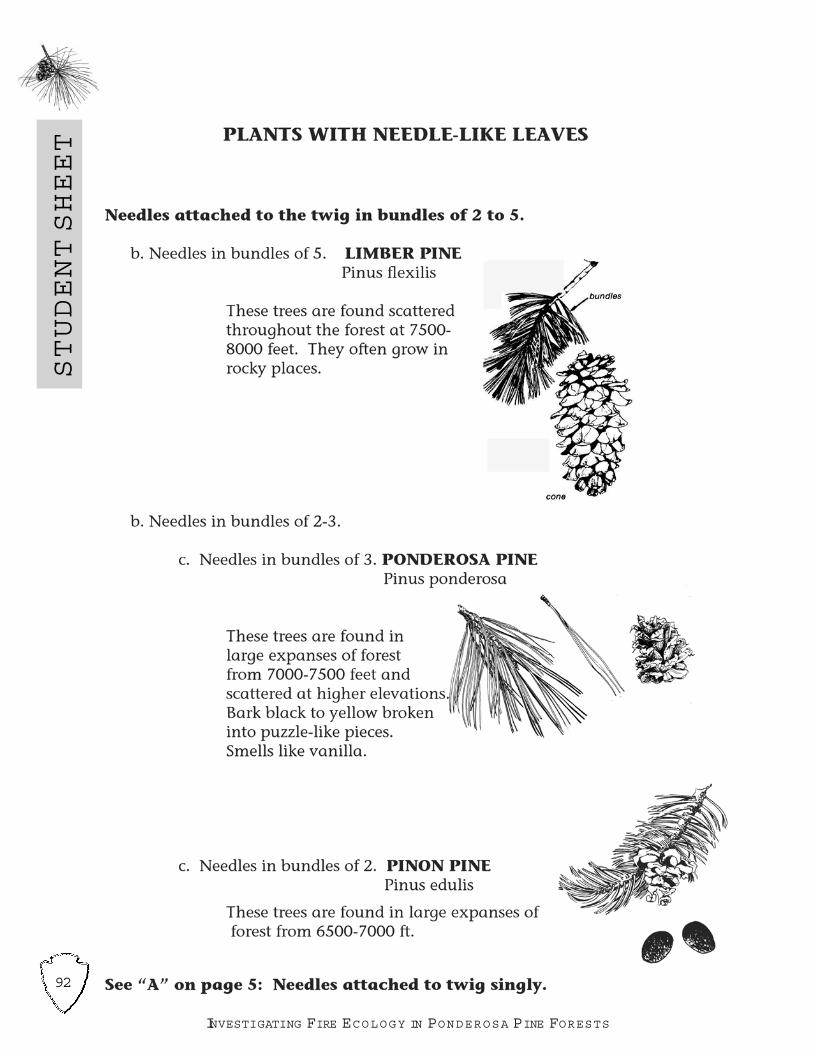
92
STUDENTSHEET
INVESTIGATING FIRE ECOLOGY IN PONDEROSA PINE FORESTS

93
JEMEZ M O U N TAINS EXPLORER G UIDES
93
STUDENTSHEET
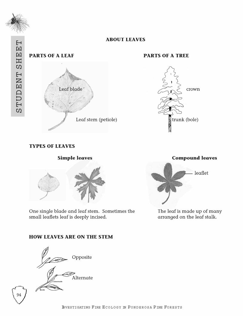
94
STUDENTSHEET
INVESTIGATING FIRE ECOLOGY IN PONDEROSA PINE FORESTS

95
JEMEZ M O U N TAINS EXPLORER G UIDES
STUDENTSHEET
Name________________________________________________________________
W ildfire and Native PlantsAssessment Questions
Comprehensive Paragraph: How do some trees, shrubs and plants protect them-selves from the heat and flames of wildland fire and make it possible to grow again ontheir own?
Vocabulary:
Forest succession a. necessary ingredient for fire to start.
Adaptation b. function of plant or animal that helps it change over
successive generations.
Serotinous c. the gradual replacement of a plant or animal com-
munity by another.
Phyrophytes d. a pine cone or seed case that requires heat from a
fire to open and release the seed.
Endangered Species e. means fire-treated plant.
Heat f. plants or animals that need protection in order to
survive.
True or False:1. Ponderosa pine and longleaf pine have thick bark to insulate them from fire, there-fore, they are the only trees capable of surviving a wildland fire.
a. True b. False2. When plant collecting, it doesn t matter how much of the plant is collected,because, as long as it is cut properly with sharp shears the plant will always growback.
a. True b. False
Multiple Choice:3. Which of the following have the slowest reproductive rate and grow more slowlythan other types of plants and therefore should only be collected sparingly?
a. grasses b. wildflowers c. vegetables d. mushrooms
4. Which type of pine cone is actually opened by the heat of a wildfire allowing the coneto drop its seed for new growth?
a. phyrophyte cones b. serotinous conesc. endangered cones d. adaptive cones
5. Forest ecosystems are always changing. Which of the following has direct interactionwithin the management of a forest ecosystem?
a. bacteria, fungi, animal waste b.insects, dying plants, animalsc. insects, animals, plants d. all of the above

96
TEACHERMASTER
INVESTIGATING FIRE ECOLOGY IN PONDEROSA PINE FORESTS
W ILDFIRE A N D NATIVE PLANTSASSESSMENT TEACHER M ASTER SHEET
Comprehensive Paragraph: How do some trees, shrubs and plants protect them-
selves from the heat and flames of wildland fire and make it possible to grow again on
their own?
Insulation, adaptive traits, reproduction, regeneration, bark thickness, heat opening
pine cones, self-protecting
Matching:Forest succession cAdaptation bSerotinous dPhyrophytes eEndangered Species fHeat a
True or False:3. Ponderosa pine and longleaf pine have thick bark to insulate them from fire, there-fore, they are the only trees capable of surviving a wildland fire. False
4. When plant collecting, it doesn t matter how much of the plant is collected, because,as long as it is cut properly with sharp shears the plant will always grow back. False
Multiple Choice:5. Which of the following have the slowest reproductive rate and grow more slowly thanother types of plants and therefore should only be collected sparingly?
b. wildflowers
6. Which type of pine cone is actually opened by the heat of a wildfire allowing the coneto drop its seed for new growth? b. serotinous cones
7. Forest ecosystems are always changing. Which of the following has direct interactionwithin the management of an forest ecosystem? d. all of the above

97
JEMEZ M O U N TAINS EXPLORER G UIDES
LESSONPLAN
Pre-Visit
MEASURING THE EARTH FROM THE GROUND UP
FOCUS QUESTIONSWhen doing a science study, how can we make estimates of distance & how can wemake precise measurements of distance?
OVERVIEW OF LESSON PLAN Students will practice measuring techniques from estimating distance with the lengthof their pace to using the Global Positioning System and its satellites to precisely maplocations around their school. They can determine the length of their pace, use meas-uring tapes and simple trigonometry to lay out a rectangle on the ground, and use aGPS to collect data about their school. Each of the activities will prepare students fortasks to which they will be assigned during the field study.
SUGGESTED TIME ALLOWANCE: 2 hours
LOCATION: Classroom, school, school yard
SUBJECT AREAS: Social Studies, Science, Math, Technology
STUDENT OBJECTIVESStudentswill: Determine their pace and apply the knowledge to measuring a part of theirschool Use simple mathematics to lay out a rectangle on the ground Know how to turn a GPS receiver on and off, and to page between the screens Know how to find their position with a GPS receiver
VOCABULARY Latitude Longitude Coordinate Satellite Global Positioning System (GPS) GPS Receiver
M ATERIALS Field journals Pencils
Estimating distance and area by pacing Measuring tapes String Pin flags GPS receivers

98
LESSONPLAN
INVESTIGATING FIRE ECOLOGY IN PONDEROSA PINE FORESTS
Pre-
Visit
Using Measuring Tapes To Lay Out A Rectangle Measuring tapes, either 10, 30, or 50 meters String Sets of four pin flags marked A through D Marking pens
THREE SCHOOLYARD ACTIVITIES FOR GPS RECEIVERSFlag Finder Pin flags marked A through M GPS receivers Datasheets
Testing GPS Accuracy 30-meter measuring tapes GPS receivers Datasheets
Where in the World is My School? Using Mapping Software GPS receivers Datasheets Mapping software, such as Terrain Navigator LCD projector
PROCEDURESThe exercises below can be run one at a time or as stations in a Measuring Marathonactivity.
Estimating distance and area by pacing1. In the school yard or in a hallway, use a measuring tape to lay out one or severallines or strings that are 10 meters long.
2. Practice walking in a normal manner, using a comfortable length of step.3. Start at the beginning of the line. Walk along the string, count the number of stepsittakes to reach the end.
4. Divide the number of steps by 10 to find the length of your pace in meters.5. Repeat three times and estimate your average pace from the three trials.6. Put out a 25 meter string. Have students estimate the length of the string.7. In a wide-open part of the school yard, mark off an area of one acre with pin flags.An acre is a square with 640-foot sides.
Using Measuring Tapes To Lay Out A Rectangle1. Locate a place in the school yard where groups of students can lay out 8 by 10meter rectangles. Make up student kits that include a measuring tape, string, fourcoded pin flags, and a marking pen. Divide students into groups of 3 or 4. Push theA pin flag into the ground as a corner of your rectangle.
2. Using the measuring tape, start at the A corner and measure a line that is 10meters long. Push in the B pin flag to mark a second corner. Run a string betweenthe two corners. Use the measuring tape to mark a spot on the string that is 3meters from the B corner.

99
JEMEZ M O U N TAINS EXPLORER G UIDES
LESSONPLAN
Pre-Visit
3. Starting at the B corner, use the measuring tape to measure a second side of yourrectangle that is 8 meters long. Estimate the right angle for now. Put the C pin flagin the ground to mark the third corner.
4. Put another string between corners B and C. Make a mark on the new string that is4 meters from corner B.
5. Have one group member take one end of the measuring tape and hold it on themark on the string that is 3 meters from corner B. Another group member shouldwalk to the other string and the mark that is 4 meters away from corner B.
6. Measure the distance between the two marks on the strings. If it is not 5 meters, haveone group member go to flag C. Keeping the string tight, move the C flag from side toside until the distance between the two marks on the strings is 5 meters.
7. Use the same technique to lay out the two remaining sides of the rectangle.
THREE SCHOOLYA R D ACTIVITIES FOR GPS RECEIVERS
Flag Finder1. Before class, scatter between 6 and 12 coded pin flags around the school yard. 2.W rite down the coordinates and letter code for each flag.3. Students should have a data sheet and GPS. Have the students walk around theschool yard and record the locations of as many pin flags as they can. Post thecorrect coordinates in the classroom and have students check their accuracy.Remember that tenths of seconds are important!
Testing GPS Accuracy1. In the school yard, lay out several 30 meter measuring tapes running north-south,east-west, or both.
2. Stand at one end of a measuring tape and record your location with the GPS. 3. Walk to the 10-meter mark on the tape and record your location again.4. Walk to the 30-meter mark and record your location again.5. Use the data sheet to figure out how far the GPS said you were from the startingpoint at each location. Remember that each one-tenth of a degree is about 9 feet.
Where in the World is My School? Using Mapping SoftwareAssign groups of students a location in the school or on the school grounds. Haveeach group record the coordinates for places like the front door, a corner of the build-ing, the library, the corner of the playground, or the principal s desk.When students return, either download the data from the GPS receivers into the com-puter using a cable connection, or enter the coordinates of each location by hand.
Project the results on a screen. How accurate is the GPS?
100
LESSONPLAN
INVESTIGATING FIRE ECOLOGY IN PONDEROSA PINE FORESTS
Pre-
Visit
EVALUATION:Evaluate each student as they go through the activities. Students should be able toset up a density plot on the field trip and to locate one of the corners with a GPSreceiver.
Students should be able to use their pace to find a distance with no more than 20 per-cent error.
Students will be able to lay out a rectangle with square corners.
Students should be able to accurately locate points with a GPS receiver and recordthe coordinates.
POTENTIAL RESOURCES:
http://www.state.de.us/planning/coord/dgdc/lessonplan1.htm
http://www.mercat.com/QUEST/Intro.htm
http://www.volunteertaskforce.org/lessonplans (PowerPoint presentation on GPS)

101
JEMEZ M O U N TAINS EXPLORER G UIDES
STUDENTSHEET
Name________________________________________________________________
Measuring the Earth from the Ground UpAssessment Questions
Comprehensive Paragraph: Explain how latitude and longitude were calculated by
16th Century explorers and how they are determined in today s world.
Matching:Latitude a. a set of numbers that describes your location on or above the
earth
Longitude b. a global navigation system based on 24 or more satellites orbit-ing the earth at an altitude of 12,000 statue miles and providingvery precise, worldwide positioning and navigation information24 hours a day.
Coordinate c. the degrees measure of how far east or west of the primemeridian a location is on Earth.
GPS Receiver d. consists of the circuitry necessary to receive the signal from asingle GPS satellite.
GPS e. the degree measure of an angle whose vertex is the center of the Earth and one side is a radius to the equator. Used to indi cate the location of a place with reference (north or south) to theequator.
True or False:1. GPS can only be used on land and not on water (like an ocean) since watercannot be magnetized.
a. True b. False
2. Since Global Positioning Systems (GPS) are a relatively new invention they areonly accurate to within 100-500 feet.
a. True b. False
Fill in:1. GPS receivers are used in conjunction with ___________________ to determinelatitude and longitude.
2. Latitude refers to distances north and south of the _______________.
3. Greenwich Meridian refers to the 0-degree of longitude. In which country is merid-ian located? ________________________.

102
TEACHERMASTER
INVESTIGATING FIRE ECOLOGY IN PONDEROSA PINE FORESTS
M EASURING THE EARTH F R O M THE G ROUND UP
ASSESSMENT TEACHER M ASTER SHEET
Comprehensive Paragraph: Explain how latitude and longitude were calculated by16th Century explorers and how they are determined in today s world.
Early explorers charted the skies: moon, stars, planets, in conjunction with horizonand season. Today location is measured with computer technology.
Matching:Latitude e
Longitude c
Coordinate a
GPS Receiver d
GPS b
True or False:
1. GPS can only be used on land and not on water (like an ocean) since water cannot
be magnetized. False
2. Since Global Positioning Systems (GPS) are a relatively new invention they are
only accurate to within 100-500 feet. False
Fill in:
GPS receivers are used in conjunction with satellites to determine latitude and longi-
tude.
Latitude refers to distances north and south of the equator.
Greenwich Meridian refers to the 0-degree of longitude. In which country is the
meridian located? England

103
JEMEZ M O U N TAINS EXPLORER G UIDES
STUDENTSHEET
M EASURING THE EARTH F R O M THE G ROUND UP DATASHEET
Flag FinderRecord the longitude and latitude of the pin flags:
A) N ____________ W ____________ E) N _________ W ____________
B) N ____________ W ____________ F) N __________ W ___________
C) N ____________ W ____________ G) N _________ W ____________
D) N ____________ W ____________ H) N _________ W ____________
Testing GPS Accuracy
Coordinates of N _________________
Coordinates at 10 meters: N_________________
the starting point: W _________________
W _________________
Each 1/10 degree equals 9 feet:
Distance you traveled north from start ___________________
Distance you traveled west from start ___________________
Coordinates at 30 meters: N _________________
W _________________
Distance you traveled north from start ___________________
Distance you traveled west from start ___________________
Where in the World is My School?
Where I took coordinates: ________________________________
Coordinates: N _________________
W _________________


105
JEMEZ M O U N TAINS EXPLORER G UIDES
LESSONPLAN
Pre-Visit
PREPARING FOR THE FIELD TRIP: FIELD JOURNALSAND PHOTO COLLAGES
FOCUS QUESTIONSHow can we best organize the data collected on a field trip? What are the basics of taking a photograph that we can use to make a photo collage?
OVERVIEW OF LESSON PLAN This lesson will prepare students for organizing their observations and data collectedon the field trip. Students will prepare and organize a field journal the will include datasheets needed on the field trip. Students will learn how to organize observationsmade in burned and unburned forests by using a Venn diagram. Using basic photog-raphy skills, they will prepare for taking a series of photos in the field to use in creat-ing a photo collage.
SUGGESTED TIME ALLOWANCE: 2 hours
LOCATION: Classroom
SUBJECT AREAS: Social Studies, Science, Language Arts, Technology
STUDENT OBJECTIVESStudentswill:
Create a field journal and understand the importance of keeping a well-organized record
Understand how a Venn diagram can organize thoughts, observations, and feel-ings
Learn basic photography techniques to use in a series of photographs for aphoto collage
VOCABULARY Observations Venn diagram Joiners
M ATERIALS Pencils Photocopied field journal sheets (provided at the end of this lesson) for eachstudent, teacher, and chaperone One package blank paper and one package lined paper Colored paper, card stock or cardboard for journal covers Magic markers or colored pencils for decorating covers 3-hole punch String, binding tape, or twigs and rubber bands for binding Pencil on a string for each student Two plastic pencils sharpeners and extra pencils for field trip One box of large ziplock bags to rainproof journals

106
LESSONPLAN
INVESTIGATING FIRE ECOLOGY IN PONDEROSA PINE FORESTS
Pre-
Visit
PROCEDURES
Creating Field Journals1. Explain to students that field journals are an effective way to record and organizethe many aspects of the information presented in this unit. Student journals caninclude writing, art work, data sheets, and general observations about their experi-ences in the field. Journals also provide a valuable assessment of student progressfor teachers.
2. Distribute photocopies of all of the unit handouts and provide each student withdouble-sided copies. Use recycled paper if it is available. Provide five additionalblank sheets of paper and five lined sheets of paper to each student.
3. Have students create front and back covers for their journals using blank sheets ofpaper.
4. Have students bind their journals using binding tape, hole punches and string,cardboard, or twigs bound by rubber bands threaded through holes. If they do notbind their journals, it is essential that students use a clipboard on the field trip.
5. Once journals are bound, have them decorate the covers. Have each studentattach a sharpened pencil on a long string through a hole in the journal binding.
6. Have students use magic markers to write their names on the front covers of theirjournals.
7. Students will need a sturdy writing surface behind their field journals. Incorporatecardboard as the last page or have clipboards available for each student.
EXTENSION IDEASCreate a journal that is used throughout the year.Share student journals with parents at open houses and/or to educate others.Students may choose to use their journals to create a class newsletter, resourcenewspaper, or a class website
Using a Venn Diagram to Organize Observations1. Introduce students to the Venn diagram as a way to graphically organize theirthoughts. Explain that the diagram is used to compare two objects, concepts, oreven people.
2. After drawing a sample on the board, ask the students to draw two overlapping cir-cles on a blank page in their field journals.
3. Ask students to identify the three areas defined in the drawing (two areas do notoverlap and one area is the overlap between the two circles).

107
JEMEZ M O U N TAINS EXPLORER G UIDES
LESSONPLAN
Pre-Visit
4. Explain that when comparing two things, some properties of each will be unique tothat object, and that the two objects will share some characteristics. Relate this tothe areas on the diagram.
5. Practice comparing two objects: friends, fruits, teachers, characters in a book,plants and animals, historic and modern forests, or surface and crown fires.
Basic Photography for a Photo Collage:1. W rite the following quote on the board: It takes time to see these pictures youcan look at them for a long time, they invite that sort of looking. But more impor-tantly, I realize that this sort of picture came closer to how we actually see, which isto say, not all-at-once but rather in discrete, separated glimpses which we thenbuild up into our continuous experience of the word. David Hockney.
2. Share several of Hockneys photo collages (from internet resources or librarybooks) with the class. Display a pre-made collage, not just prints and internet pic-tures. The ideas of a collage are more clearly seen when students can actuallysee and touch a collage.
3. Discuss with students why they think Hockney combined hundreds of photos for his compositions instead of just taking a single snapshot. What is unique aboutthese compositions? What techniques of his can you use to develop your own col-lages?
4. Discuss what makes a good photograph. Some helpfultips are: Shoot tight (close to your subject). Be aware of what is in your background. Watch that your fingers don t block the lens. Hold the camera steady: squeeze the shutter button gently. Surprise is an important ingredient in a good photograph. Photograph your sub-ject from unexpected angles. Low angles can exaggerate the height of tall sub-jects or reveal unseen aspects. A shift in lateral position or any extreme viewpointcan also produce angles.
POTENTIAL RESOURCES:
http://www.ibiblio.org/wm/paint/auth/hockney
http://www.getty.edu/artsednet/resources/Look/Landscape/hockney.html.
http://www.mcs.csuhayward.edu/~malek/Hockney.html
http://www.artandculture.com/cgi-bin/WebObjects/ACLive.woa/wa/artist?id=262

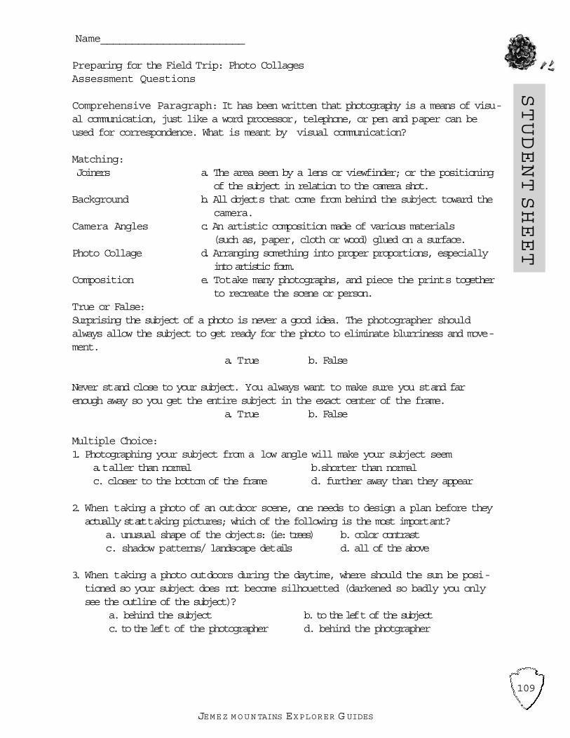
109
JEMEZ M O U N TAINS EXPLORER G UIDES
STUDENTSHEET
Name_______________________
Preparing for the Field Trip: Photo CollagesAssessment Questions
Comprehensive Paragraph: It has been written that photography is a means of visu-al communication, just like a word processor, telephone, or pen and paper can beused for correspondence. What is meant by visual communication?
Matching:Joiners a. The area seen by a lens or viewfinder; or the positioning
of the subject in relation to the camera shot.Background b. All objects that come from behind the subject toward the
camera.Camera Angles c. An artistic composition made of various materials
(such as, paper, cloth or wood) glued on a surface.Photo Collage d. Arranging something into proper proportions, especially
into artistic form.Composition e. Totake many photographs, and piece the prints together
to recreate the scene or person.True or False:Surprising the subject of a photo is never a good idea. The photographer shouldalways allow the subject to get ready for the photo to eliminate blurriness and move-ment.
a. True b. False
Never stand close to your subject. You always want to make sure you stand farenough away so you get the entire subject in the exact center of the frame.
a. True b. False
Multiple Choice:1. Photographing your subject from a low angle will make your subject seem
a.taller than normal b.shorter than normalc. closer to the bottom of the frame d. further away than they appear
2. When taking a photo of an outdoor scene, one needs to design a plan before theyactually starttaking pictures; which of the following is the most important?
a. unusual shape of the objects: (ie: trees) b. color contrastc. shadow patterns/ landscape details d. all of the above
3. When taking a photo outdoors during the daytime, where should the sun be posi-tioned so your subject does not become silhouetted (darkened so badly you onlysee the outline of the subject)?
a. behind the subject b. to the left of the subjectc. to the left of the photographer d. behind the photgrapher

110
TEACHERMASTER
INVESTIGATING FIRE ECOLOGY IN PONDEROSA PINE FORESTS
PREPARING FOR THE FIELD TRIP: PHOTO COLLAGES
ASSESSMENT TEACHER M ASTER SHEET
Comprehensive Paragraph: It has been written that photography is a means of visu-al communication, just like a word processor, telephone, or pen and paper can beused for correspondence. What is meant by visual communication?
Any answer that the student develops some connection with visual responses, and howto apply these responses in a real-life situation. Students should realize that photogra-phy can be a teaching and learning tool.
Matching:Joiners cBackground bCamera Angles aPhoto Collage eComposition d
True or False:Surprising the subject of a photo is never a good idea. The photographer shouldalways allow the subject to get ready for the photo to eliminate blurriness and move-ment. False
Never stand close to your subject. You always want to make sure you stand farenough away so you get the entire subject in the exact center of the frame. False
Multiple Choice:1. Photographing your subject from a low angle will make your subject seem?
a.taller than normal
2. When taking a photo of an outdoor scene, you need to design a plan before youactually starttaking pictures; which of the following is the most important? d. all ofthe above
3. When taking a photo outdoors during the daytime, where should the sun be posi-tioned so your subject does not become silhouetted (darkened so badly you onlysee the outline of the subject)? a. behind the photographer

111
JEMEZ M O U N TAINS EXPLORER G UIDES
JOURNALSHEET
K EEPING A RECORD O F YO U R W O R K
EXPECTATIONS FOR FIELD JOURNALS
Reasons for keeping a journal:
To teach you about documentation
To help you be organized
To have a place for your comments, observations, thoughts, questions, and reflec-
tions
Items that will be recorded in your journal:
Data collection sheets
Brief notes on activities done in class
Observations and reflections
Notes on class discussions and reading done on your own
Assignments you are asked to do
Anything else you choose to write that is relevant to the topic being studied
Requirements and Expectations:
All journal pages should be numbered and both sides of the page
should be used.
All journal entries should be dated (day, month, year).
All entries should be in pencil unless instructed otherwise.
Pages should never be torn out.
Journal entries should contain an interesting variety of writing styles, methods, and
products including illustrations, pictures, and graphs.
Main ideas should be clearly presented.
Consistent use of appropriate science language and terminology should
be present.
Effective use of models, diagrams, charts, and graphs should be utilized.
Journals should contain information on experiments (procedures used, actual data,
analysis of data, and conclusions).
Entries should be well-organized, legible, and neat.
All notes and assignments should be completed on time.
Organization is important a reader should be able to follow what you
have written.
All entries should be accompanied with a heading to indicate to the reader what the
entry is about.
Evaluation of your journal:
Journals will be collected and graded in two week intervals.
You will be evaluated on:
1. Whether you have completed all of the assigned journaling prompts and if you have
followed the above guidelines.
2. If your journal reflects a variety of thoughtful responses to the subject
matter.

112
JOURNALSHEET
INVESTIGATING FIRE ECOLOGY IN PONDEROSA PINE FORESTS
FIELD JOURNAL RATING SCALE
Rate as follows: 4 = Extends/Exceeds 3 = Practitioner 2 = Apprentice
1 = Novice NA = Not Applicable
1. Journal pages are numbered. 4 3 2 1 NA
2. Both sides of the page are used. 4 3 2 1 NA
3. Journal entries are dated (day, month, year). 4 3 2 1 NA
4. All entries are in pencil unless instructed otherwise. 4 3 2 1 NA
5. Pages are not torn out. 4 3 2 1 NA
6. Journal entries contain an interesting variety
of writing styles, methods, and products including illustrations, pictures
and graphs. 4 3 2 1 NA
7. Main ideas are clearly presented. 4 3 2 1 NA
8. Consistent use of appropriate science language
and terminology is present. 4 3 2 1 NA
9. Effective use of models, diagrams, charts, and
terminology is present. 4 3 2 1 NA
10. Journal contains information on experiments (procedures used, actual data, analy-
sis of data, and conclusions). 4 3 2 1 NA
11. Entries are well-organized, legible, and reasonably neat. 4 3 2 1 NA
12. All notes and assignments are completed on time. 4 3 2 1 NA
13. Journal is organized. 4 3 2 1 NA
14. All entries are accompanied with a heading. 4 3 2 1 NA
Comments:

113
JEMEZ M O U N TAINS EXPLORER G UIDES
JOURNALSHEET
FIELD JOURNAL KEY
4 = Extends/ExceedsThe student consistently meets and at times exceeds ( more depth/extension withgrade level work and/or performing at a higher grade level) the standard as it isdescribed the grade level key indicators. The student, with relative ease, grasps,applies and extends the key concepts, processes, and skills or the grade level.Thework is the student s best effort.
3 = PractitionerStudent s work demonstrates solid academic performance. The student regularlymeets the standard as it is described in the grade level key indicators. The student,with limited errors, grasps and applies the key concepts, processes, and skills for thegrade level.
2 = Apprentice Student s work demonstrates partial mastery of prerequisite knowledge and skills thatare fundamental for proficient work at the grade level. The student is beginning to,and occasionally does, meet the standard as it is described by the grade level keyindicators. The student is beginning to grasp and apply the key concepts, processesand skills at the grade level but produces work that contains many errors.
1 = Novice Student s work is yet to demonstrate partial mastery of the knowledge and skills thatare fundamental for proficient work at the grade level. The student is not meeting thestandard as it is described by the key indicators for this grade level. The student isworking on key indicators that are one or more years below grade level.
N A = Not ApplicableThis particular concept has not yet been taught or is not yet ready for evaluation.

114
JOURNALSHEET
INVESTIGATING FIRE ECOLOGY IN PONDEROSA PINE FORESTS
SAFETY
Safety is first and foremost. Safety concerns change as forest succession proceeds.In the early stages of succession, root burn-out and falling rocks are issues to bedealt with. As the trees begin to fall, hazard trees and ground litter become important.Other hazards are present regardless of the stage of succession: lack of water, poi-sonous plants and animals, rolling rocks, and tripping hazards. Below are outlinedsome hazards that should be discussed with the students before going into the field.
Safety Issues:
1) Sufficient Water: In this dry climate sufficient water isessential. Each student should bring approximatelyone quart of water, or water should be supplied by thefield trip leader.
2) Sunburn: At high elevations the sun is intense. Sunscreen on exposed skin surfaces should be encouraged.
3) Poisonous Plants: Poison ivy causes rashes andsprouts after a fire. Leaves of three, let it be is agood motto.

115
JEMEZ M O U N TAINS EXPLORER G UIDES
4) Poisonous Snakes: Most snakes are not poi-sonous; however, the Prairie Rattlesnake canbe present in forests. The best defense is mov-ing the group away from any snake that isfound. Do not kill any snakes.
5) Hazard Trees: Trees that are leaning or havesnapped off are considered hazard trees.Activities should not be done in a burnedarea when there are winds.
6) Rolling Rocks: Immediately after a fire there is notmuch vegetation to hold rocks on slopes. When a rockis loosened the student should yell Rock, warninganyone below them of the rock hazard.
7) Lightning: It is not safe to be on mesa tops or under trees during lightning storms. Lightning can strike you directly or indirectly through nearby objects. Take shelter in a building if a lightning storm arrives during your field trip.
JOURNALSHEET

116
JOURNALSHEET
INVESTIGATING FIRE ECOLOGY IN PONDEROSA PINE FORESTS
PLANT SC AVENGER HUNT CHECK LIST
Shrubs
❑ Gambel Oak Quercus gambelii
❑ Mountain Mahagony Cercocarpus montanus
❑ Gooseberry Ribes cereum
❑ W ild Rose Rosa woodsii
❑ Raspberry Rubus strigosus
❑ New Mexico Locust Robinia neomexicana
❑ Chokecherry Prunus virginiana
Subshrubs❑ Kinnikinnik Arctostaphylos uva-ursi❑ Mountain Lover Pachystima myrsinites❑ Poison Ivy Rhus radicans
Invasive Plants
❑ Cheatgrass Bromus tectorum
Non-native Plants
❑ California Poppy❑ Blue Flax Lenum levesii
Native Plants
RED FLOWERS:
❑ Indian Paintbrush Castilleja integra
❑ Scarlet Bugler Penstemon barbatus
❑ Scarlet Trumpet Ipomopsis aggregata
PURPLE FLOWERS:
❑ Gayfeather Liatris punctata
❑ W ild Onion Allium cernuum
❑ Townsend s Aster Townsendia incana
❑ Aster Aster app
❑ Daisy Erigeron app
❑ James geranium Geranium Caespitosum
❑ Beardtongue Penstemon Geranium Caespitosum

117
JEMEZ M O U N TAINS EXPLORER G UIDES
JOURNALSHEET
YELLOW FLOWERS:
❑ Goldenrod Solidago app
❑ W ild Chrysanthemum Bahia dissecta
❑ Snakeweed Gutierrezia sarothrae
❑ Pinque Hymenoxys richardsonii
❑ Mullein Verbascum thapsus
❑ Mustard Sisymbrium altissimum
❑ Rocky Mountain Bee-Plant Cleome serrulata
W EEDY O R GREEN TO BLUEGREEN:
❑ False tarragon Dracunculus
❑ Chenopods Cheapodiaim app
❑ Sage Artemisia ludoriiciana
W HITE FLOWERS:
❑ Pussytoes Antennaria parvifolia
❑ Fleabane Daisy Erigeron divergens
Grasses
❑ Mountain Muhly Muhlenbergia montana
❑ Little Bluestem Andropogon scoparius
❑ Slender Wheatgrass Trachycaulum
❑ Bromus
Trees
❑ Limber Pine Pinus flexilis
❑ Ponderosa Pine Pinus ponderosa
❑ Aspen Populus Tremuloides
117

118
JOURNALSHEET
INVESTIGATING FIRE ECOLOGY IN PONDEROSA PINE FORESTS
PLANT SC AVENGER HUNT O BSERVATIONS
Use this sheet to draw and label two native plants of your choice.

119
JEMEZ M O U N TAINS EXPLORER G UIDES
JOURNALSHEET

120
JOURNALSHEET
INVESTIGATING FIRE ECOLOGY IN PONDEROSA PINE FORESTS
PLANT DATA INFORMATION
Common name refers to the name people in a region call the plant. Often thesenames express characteristics of the plant. Common names presenta problem because the same name is often applied to more than oneplant.
Scientific name refers to the name the scientific community has givento the plant.
Location refers to the specifics of where the plant was found.
Habitat refers to specific details of micro-habitat. Important points are type of soil orother substrate (sand, clay, granite, dead wood, other vegetation), associatedspecies, moisture, and aspect (fully exposed on a south facing bank; in adamp hollow under dense scrub, etc.).
Description of plant includes everything about the plant that is not obvious on theidentification sheet. Essential items are the height, type of bark,whether the stem is upright, sprawling or drooping, obvioussmells, whether the plant is clumped, single or growing in patch-es, and the presence of creeping or underground stems. Flowerand fruit color should also be noted as these often fade on driedspecimens.
Surrounding vegetation also helps describe the site. For example Surrounded byscrub oak with an abundance of asters nearby.
Date refers to the day the plant is observed or collected.

121
JEMEZ M O U N TAINS EXPLORER G UIDES
JOURNALSHEET
PLANT DATA SHEET
Name of student: _______________________________________ Date: _________
Common name of plant:_________________________________________________
Scientific name of plant: ________________________________________________
Location: ____________________________________________________________
Habitat: _____________________________________________________________
Surrounding vegetation: ________________________________________________
Description of plant:
PLANT DATA SHEET
Name of student: ________________ _______________________ Date: _________
Common name of plant:_________________________________________________
Scientific name of plant: ________________________________________________
Location collected: _____________________________________________________
Habitat: _____________________________________________________________
Surrounding vegetation: _________________________________________________
Description of plant:

122
JOURNALSHEET
INVESTIGATING FIRE ECOLOGY IN PONDEROSA PINE FORESTS

123
JEMEZ M O U N TAINS EXPLORER G UIDES
JOURNALSHEET

124
JOURNALSHEET
INVESTIGATING FIRE ECOLOGY IN PONDEROSA PINE FORESTS