investigation reportewebapps.worldbank.org/apps/ip/panelcases/60...the inspection panel has prepared...
TRANSCRIPT

Investigation Report
Cambodia: Land Management and Administration Project (Credit No. 3650 - KH)
November 23, 2010
Report No. 58016-KH
i
About the Panel
The Inspection Panel was created in September 1993 by the Board of Executive Directors of the World Bank to serve as an independent mechanism to ensure accountability in Bank operations with respect to its policies and procedures. The Inspection Panel is an instrument for groups of two or more private citizens who believe that they or their interests have been or could be harmed by Bank-financed activities to present their concerns through a Request for Inspection. In short, the Panel provides a link between the Bank and the people who are likely to be affected by the projects it finances. Members of the Panel are selected “on the basis of their ability to deal thoroughly and fairly with the request brought to them, their integrity and their independence from the Bank’s Management, and their exposure to developmental issues and to living conditions in developing countries.”1
The three-member Panel is empowered, subject to Board approval, to investigate problems that are alleged to have arisen as a result of the Bank having failed to comply with its own operating policies and procedures.
The Panel’s work embraces the fundamental principles of independence, integrity, and impartiality. These cornerstone principles enable the Panel to respond to the issues raised and to provide technically sound, independent
assessments to the Bank’s Board.
Processing Requests After the Panel receives a Request for Inspection, it is processed as follows:
• The Panel decides whether the Request is prima facie not barred from Panel consideration.
• The Panel registers the Request—a purely administrative procedure. • The Panel sends the Request to Bank Management, which has 21 working days to
respond to the allegations of the Requesters. • The Panel then conducts a short 21 working-day assessment to determine the eligibility
of the Requesters and the Request. • If the Panel recommends an investigation, and the Board approves it, the Panel
undertakes a full investigation, which is not time-bound. • If the Panel does not recommend an investigation, the Board of Executive Directors may
still instruct the Panel to conduct an investigation if warranted. • Three days after the Board decides on whether or not an investigation should be carried
out, the Panel’s Report (including the Request for Inspection and Management’s Response) is publicly available through the Panel’s website and Secretariat, the Bank’s Info Shop and the respective Bank Country Office.
• When the Panel completes an investigation, it sends its findings and conclusions on the matters alleged in the Request for Inspection to the Board as well as to Bank Management.
1 IBRD Resolution No. 93-10; IDA Resolution No. 93-6.

ii
• The Bank Management then has six weeks to submit its recommendations to the Board on what actions the Bank would take in response to the Panel’s findings and conclusions.
• The Board then takes the final decision on what should be done based on the Panel's findings and the Bank Management's recommendations.
• Three days after the Board’s decision, the Panel’s Report and Management’s Recommendation are publicly available through the Panel’s website and Secretariat, the Bank’s Project website, the Bank’s Info Shop and the respective Bank Country Office.

iii
Acknowledgements
The preparation of this Report would not have been possible without the support and valuable contributions of many people. The Panel wishes to thank the Requesters and the communities who met with the Panel in the Project areas.
The Panel expresses its appreciation to the many national and local government officials in Cambodia with whom the Panel met. They provided valuable insights and information. The Panel is also grateful to the Cambodia country team for their assistance. The Panel also wishes to thank the World Bank Staff in Washington D.C. and in the Cambodia office for assisting with logistical arrangements. The Panel wishes to thank Bank Management and Staff for their assistance in obtaining documents, providing the Panel with information, and responding promptly to written requests. The Panel also wishes to extend its thanks to the members of civil society organizations working in Cambodia. The Panel is grateful for the expert advice provided by Mr. Geoffrey Payne and appreciates the objective judgment and professionalism he exhibited at all times. Finally, the Panel wishes to convey its gratitude and appreciation to the members of its Secretariat for their resourceful handling of this investigation, in particular to Ms. Dilek Barlas, Deputy Executive Secretary, and Ms. Katherine Chung and Ms. Jennifer Hatch, Research Assistants.

iv
Abbreviations, Acronyms, and Terms
ADB Asian Development Bank BP Bank Policy BTO Back to Office Report BKL Boeung Kak Lake CAS Country Assistance Strategy CIDA Canadian International Development Agency CLP Council for Land Policy COHRE Centre for Housing Rights and Evictions DCA Development Credit Agreement DfID Department for International Development (United Kingdom) DPM Deputy Prime Minister EA Environmental Assessment ERM Enhanced Review Mission ESG Environmental and Social Guidelines GTZ Deutsche Gesellschaft für Technische Zusammenarbeit IDA International Development Association LMAP Land Management and Administration Project LRT Land Registration Team MEF Ministry of Economy and Finance MLMUPC Ministry of Land Management, Urban Planning, and Construction MPP Municipality of Phnom Penh MR Management Response MTR Mid-term Review NALDR National Authority for Land Dispute Resolution NCRUDC National Committee for Regional and Urban Development and
Construction NGO Nongovernmental Organization OD Operational Directive OP Operational Policy PACP Public Awareness Community Participation PAD Project Appraisal Document PMO Project Management Office RGC Royal Government of Cambodia ROW Right of Way RPF Resettlement Policy Framework RVP Regional Vice President SA Social Assessment SDR Special Drawing Rights TOR Terms of Reference UN United Nations UNCHS United Nations Human Settlements Programme/Centre for Human
Settlements (UN HABITAT) UNDP United Nations Development Program UNTAC United Nations Transitional Authority in Cambodia URC Urban Resource Center US $ United States Dollars

v
Overview
The Inspection Panel has prepared this Investigation Report in response to the Request for Inspection received on September 4, 2009 from the Centre for Housing Rights and Evictions (COHRE), which submitted the Request on behalf of communities claiming to have been affected by the Land Management and Administration Project (hereinafter referred to as the “Project” or “LMAP”) in Cambodia. These communities are situated in the Boeung Kak Lake (BKL) area, within the Sras Chok commune, Daun Penh district in the Municipality of Phnom Penh. The Requesters asked the Panel to keep the names of the affected people and the villages where they live confidential. The Panel registered the Request for Inspection on September 24, 2009. Management submitted its Response to the Request on November 2, 2009.
A Panel team visited Cambodia during November 16-19, 2009 to determine the eligibility of the Request. The Panel submitted its Eligibility Report and Recommendation to the Executive Directors on December 2, 2009. The Panel found the Request eligible, but refrained from making a recommendation at that time on whether an investigation was warranted, noting that it expected to make such a determination by March 31, 2010. In the Panel’s view, this would give Management a further chance to establish a dialogue with the Government of Cambodia and other Development Partners to address the concerns of the Requesters. The Board approved the Panel’s recommendation on December 16, 2009, on a non-objection basis.
The Panel submitted its Final Eligibility Report to the Executive Directors on March 31, 2010. The Panel noted that no progress had been made to implement the actions proposed in the Management Response to address the Requesters’ concerns. Accordingly, the Panel recommended that the Board of Executive Directors approve an investigation of the claims and matters raised in the Request for Inspection. The Board approved the Panel's recommendation for a Panel investigation on April 13, 2010, on a non-objection basis. Key Claims Presented to the Panel. In their Request for Inspection, the Requesters alleged that activities under the World Bank-financed LMAP caused the Boeung Kak Lake community, of about 4,250 families, to suffer serious harm from the design and implementation of the Project. The Requesters claimed that evictions and related events in the BKL area are linked to the Project, and that they were denied adjudication of their property claims under LMAP. The Requesters stated that the BKL area was re-classified to enable development by a private developer, depriving the affected community of the opportunity to have their land rights considered under the Project, leading to their forced evictions. They claimed that regardless of the status of ownership of the land, residents in the BKL area had already been, and continued to be, evicted in a manner that violated Bank Policy on Involuntary Resettlement and the Resettlement Policy Framework (RPF) agreed for the Project. The Requesters claimed that the Project “failed to formalize their tenure” and did not “transfer their customary rights under formalized land titles,” therefore weakening pre-existing tenure rights of people. Finally, the Requesters claim that other communities in Project Provinces have been unable to access the land titling in LMAP adjudication areas, and experienced forced evictions. The issues raised involve fundamental questions of land rights and tenure security of the affected community.

vi
Panel Findings on Compliance and Harm. This Report presents the findings of the Panel in response to these claims, in particular on whether the alleged harms have totally or partially resulted from serious Bank failure to observe its operational policies and procedures with respect to project design, appraisal and/or implementation. The policies relevant to this investigation pertain to Project Appraisal, Involuntary Resettlement and Project Supervision. On the claim that the events in the BKL area are linked to the Project, the Panel found that the area is within a Project Province and was declared for adjudication under LMAP, hence activities relating to verification of land tenure and ownership subsequent to the notice of adjudication are directly linked to the Project. This is consistent with Management’s position.
On the claim that residents of the BKL area were denied adjudication of their property claims under the Project, the Panel concluded that residents in the BKL area were denied access to a due process of adjudication of their property claims. It is the Panel’s view that residents of the BKL area were justified in expecting that their claims to land were eligible for consideration under systematic land titling, and furthermore that all land claims in the commune were to be adjudicated in accordance with the procedures and processes for adjudication of property claims, agreed between the Government, Bank and Development Partners supporting LMAP. The Panel found that ambiguities in the Project design, both with respect to determining adjudication areas and in dealing with disputes between State entities and private individuals during the adjudication process, in part contributed to the harm that Requesters are facing. Furthermore, the Panel found that Management failed to act on information when the problems arising in the BKL area was first brought to its attention, and that Management’s supervision in this respect was not consistent with the requirements of Bank policy. While Management’s recent supervision of the Project, on issues raised by the Request, complies with Bank policy, the Panel concurs with the Requesters’ assessment that “it is evident that the actions taken by the Bank Management were too late to prevent the harms now being done.”
On the claim that residents of the BKL area were displaced in violation of agreed policies for involuntary resettlement, the Panel found that the decision to prepare a Resettlement Policy Framework complied with the provisions of the applicable policy and commended Management for broadening the range of situations where the Resettlement Policy Framework would apply, reflecting new thinking within the Bank at the time regarding the proper application of the Bank’s safeguards. Nevertheless, because of ambiguities with respect to how the Resettlement Policy Framework should be triggered and applied, the Panel found that the design of the Resettlement Policy Framework fell short of the provisions anticipated in the OD 4.30 with respect “planning principles, institutional arrangements, and design criteria.” The Panel found evidence in the supervision records that Management on several occasions raised issues related to State land management potentially relevant for the application of the RPF, and commended the Bank for pursuing this difficult policy issue in the Cambodian context. However, the Panel found that evictions took place from State land, leading to grave harm to the affected families, and that the Resettlement Policy Framework should have been applied in the BKL area. Overall, the Panel is of the view that Bank Management should have detected the serious problems faced by people in the BKL area at an earlier stage, and considered appropriate actions. Failing to do so was not in compliance with Bank policy.

vii
On the claim that the titling process adopted by the Project weakened pre-existing tenure rights, the Panel found that design flaws in the Project led to arbitrary exclusion of lands from the titling process and denied residents the opportunity to claim and formalize their pre-existing rights through adjudication under LMAP. It is the Panel’s view that this contradicts the stated objective of the Project to improve land tenure security, especially for poor and vulnerable people, and consequently the Panel found that Management was not in compliance with Bank Policy on Project Appraisal. The Panel also found that not all measures specifically designed to support poor and vulnerable people were implemented as planned. Management did not adequately follow up Project commitments to strengthen public awareness and community participation, ensure legal protection to residents exposed to the risk of eviction, and provide adequate access to dispute resolution mechanisms, which was not in compliance with Bank policy. The Panel found that lack of support for the poor due to incomplete and inadequate implementation of several components of the Project left them vulnerable to claims on their land. Management in its Response confirms that these activities, which are important to the full implementation of the Project were delayed or were not implemented.
The final claim of the Requesters was that other communities in LMAP adjudication areas have been excluded from the adjudication process and experienced forced evictions. The Panel noted that forced evictions are not a new occurrence in Cambodia, and have been ongoing in Phnom Penh since well before the preparation of the Project. While the extent of the negative impact on families living in adjudication areas is unknown, the Panel is extremely concerned about the large number of people who were forcibly evicted, displaced, or are under threat of eviction in Project areas. The Panel found that due to lack of a robust monitoring and evaluation system for the Project, Bank Management did not become aware of significant issues arising from the Project, which does not comply with Bank policy.
Additional Observations. The Panel wishes to underscore that it considers the Bank’s engagement on land issues in Cambodia highly relevant to the country’s development and consistent with both the Government’s long-term development vision and the Bank’s overall mandate of poverty reduction.
In this context, and without diminishing in any way the significance of its findings, the Panel wishes to record its appreciation of Management’s Response to the Request for Inspection and its frank assessment of issues of both harm and compliance. The Panel concurs with Management’s view on the principal issue of linkage between the Project and the evictions from the BKL area. Moreover, the Panel finds that a series of proactive actions taken by Management from January 2009 to date comply with the provisions of Bank policy on project supervision. In particular, the Enhanced Review Mission carried out in March-April 2009 was instrumental in highlighting several shortcomings in Project design, implementation and supervision. The Panel investigation both confirms and broadens the findings of the Enhanced Review Mission. The Panel hopes that this Investigation Report will contribute to the start of a new engagement with the Government on the resolution of issues raised by the Requesters.
The Panel believes that this case highlights the value of having an independent avenue of recourse for project-affected people. As documented in this report, the engagement of Requesters via the Inspection Panel process furthered a pro-active involvement by Bank Management and led to a careful review of the serious issues raised. Moreover, as part of this process,

viii
Management conducted a field review and identified at least 2,600 more families who had been evicted or are at risk of eviction in Project areas.

ix
Table of Contents About the Panel ................................................................................................................................ i
Acknowledgements ........................................................................................................................ iii
Abbreviations, Acronyms, and Terms ........................................................................................... iv
Overview ......................................................................................................................................... v
Table of Contents ........................................................................................................................... ix
EXECUTIVE SUMMARY ........................................................................................................... xi
Chapter 1: The Request for Inspection, Management Response and Investigation Process .......... 1
A. Organization of the Report .................................................................................................. 1 B. The Request for Inspection ..................................................................................................... 1 C. Management Response ............................................................................................................ 2
1. General Observations ....................................................................................................... 2
2. Response to the Request for Inspection ........................................................................... 4
3. Special Issues and Action Plan ........................................................................................ 5
D. The Investigation Process .................................................................................................... 5 1. Panel’s Initial Eligibility Report and the Eligibility of the Request ................................ 5
2. Final Eligibility Report .................................................................................................... 6
3. The Investigation Methodology ....................................................................................... 7
4. Relevant Bank Policies .................................................................................................... 8
Chapter 2: The Project, its Context, and the Events in the Boeung Kak Lake Area .................... 11
A. Overview ............................................................................................................................ 11 B. The Land Management and Administration Project (LMAP)............................................... 11 C. Key Aspects of the Project Context ...................................................................................... 13
1. Tenure Regimes ............................................................................................................. 13
2. State Land Management ................................................................................................. 16
3. Institutional Structure of Land Administration .............................................................. 19
4. Tenure Security in Phnom Penh ..................................................................................... 20
D. Background to the Events in the BKL Area ...................................................................... 24 1. History of Settlement in the Area................................................................................... 24
2. Land Tenure Categories in the Area .............................................................................. 26
3. Development Initiatives for the Area ............................................................................. 26
4. The Adjudication Process Under the Project ................................................................. 28
5. Forced Evictions from the BKL Area ............................................................................ 30
Chapter 3: Panel’s Analysis and Findings .................................................................................... 33
A. Overview ............................................................................................................................. 33 B. Claim That the Events in Boeung Kak Lake Area Are Linked to the Project...................... 34
x
1. Requesters’ Claim and Management Response ............................................................. 34
2. Panel Analysis ................................................................................................................ 34
C. Claim That Residents of Boeung Kak Lake Were Denied Adjudication of Their Property Claims Under the Project ...................................................................................................... 36 1. Requesters’ Claim and Management Response ................................................................ 36
2. Panel Analysis ................................................................................................................ 37
3. Compliance Findings ..................................................................................................... 46
D. Claim That Residents of the Boeung Kak Lake Area Were Displaced in Violation of Agreed Policies for Involuntary Resettlement ...................................................................... 51 1. Requester’s Claim and Management Response ................................................................ 51
E. Claim That Titling Process Adopted By the Project Weakens Pre-existing Tenure Rights 62 1. Requesters’ Claim and Management Response ............................................................... 62
2. Panel Analysis ................................................................................................................ 63
3. Compliance Findings ......................................................................................................... 66
F. Claim That Other Communities in Project Provinces Have Experienced Forced Evictions 69 1. Requesters’ Claim and Management Response ............................................................... 69
2. Panel Analysis ................................................................................................................ 70
3. Compliance Findings ..................................................................................................... 72
Chapter 4: Lessons and Systemic Issues....................................................................................... 74
ANNEX 1: Table of Findings ....................................................................................................... 76 ANNEX 2: Biographies ................................................................................................................ 85
Boxes Box 1: An Example of an Affected Family .................................................................................... 3Box 2: History of Land Tenure Regimes in Cambodia* .............................................................. 15Box 3: Flooding Concerns From the Filling in of the Boeung Kak Lake* .................................. 32
Figures
Figure 1: Slum population in Cambodia and Figure 2:Slum population in Phnom Penh ............ 23Figure 3: Aerial Photo of Boeung Kak Lake (Mann Lim, 2006) ................................................. 24
Pictures
Picture 1 Dense Housing in BKL Area ......................................................................................... 25Picture 2: House Flooded on Boeung Kak Lake ........................................................................... 31Picture 3: Panel Team Meets with Affected Community in the BKL Area ................................. 35Picture 4: Sand Filling Boeung Kak Lake .................................................................................... 40Picture 5: The Resettlement site, Damnak Troyeung, some 20 km away from Phnom Penh ...... 61Picture 6: House Covered in Mud During Recent Lake Filling, Courtesy of BABSEA .............. 66

xi
EXECUTIVE SUMMARY
The Inspection Panel has prepared this Investigation Report in response to the Request for Inspection dated September 4, 2009, related to the Cambodia: Land Management and Administration Project (hereinafter referred to as “LMAP” or the “Project”). The Panel’s Report is presented in four chapters.
The Request for Inspection, Management Response and Investigation Process
The Request
The Request for Inspection was submitted by the Centre for Housing Rights and Evictions (COHRE), on behalf of communities affected by the Cambodia: Land Management and Administration Project (hereinafter referred to as the “Project” or “LMAP”). These communities, consisting of about 4,250 families, are situated in the Boeung Kak Lake (BKL) area, within the Sras Chok commune, Daun Penh district in the Municipality of Phnom Penh. The term “BKL area” represents the 133 hectares, including the lake (approx. 90 hectares) and surrounding areas, which in 2007 was leased to a private developer. The first claim in the Request is that activities under the World Bank-financed LMAP contributed to causing serious harm suffered by residents in the Boeung Kak Lake area. The Panel notes that the Government of Cambodia does not recognize a link between the events in the BKL area and the Land Management and Administration Project (LMAP). Bank Management, by comparison, considers that this link does exist, in agreement with the claim of Requesters. Secondly, the Requesters claim that people in the BKL area were denied their right to have their property claims considered and adjudicated under the Project. According to the Request, despite the fact that the whole of Sras Choc commune had been declared an adjudication area under LMAP, people were told that adjudication in the BKL was not carried out on the ground that the land fell within a “development zone”. The Requesters believe that the BKL area was re-classified to enable development by a private developer, depriving the affected community of the opportunity to have their land rights considered under the Project, leading to their forced evictions. Thirdly, the Requesters claim that regardless of the status of ownership of the land, residents in the BKL area have already been and continue to be evicted in a manner that violates the Resettlement Policy Framework (RPF) for the Project, as required under the Development Credit Agreement (DCA). It is variously estimated that more than 1,500 families have already been evicted, with an even larger number of families under threat of eviction. The Requesters
xii
complain about inadequate compensation, pressure and intimidation to make people vacate their houses, and flooding of homes caused by the filling of the lake by the developer. Fourthly, the Request alleges that the LMAP, which seeks to create a centralized and formal land registration process, has resulted in weakening pre-existing tenure rights based on customary or informal tenure regimes. Finally, according to the Requesters, not only in the BKL area but also in other urban and rural communities, including indigenous communities, throughout Cambodia, people have been unable to access the land titling in LMAP adjudication areas, and/or the dispute resolution mechanisms envisaged under LMAP.
Management Response
General observations. The Management Response notes that, according to the Project Appraisal Document (PAD), LMAP was to be carried out in accordance with the Bank’s Environmental and Social Policies, but the Project was not likely to cause any involuntary resettlement. Nevertheless, a RPF had been prepared which inter alia could be applied in the event of evictions from State land due to systematic and sporadic titling activities.
The Management
Response further notes that titling activities under the Project are stipulated as not covering informal settlers or “squatters” on State land as the Project was not envisaged to regularize informal settlements. Management contends that the LMAP generated “significant development benefits”, although Management acknowledges that the absence of relevant baseline data or a defined methodology for collecting data inhibit accurate measurement of improvements in land tenure security.
Response to the Request for Inspection. The Management Response states that despite being situated within the Sras Chok commune, the BKL area was not included in the adjudication of property claims. The reasoning was stated as being that the Municipality of Phnom Penh (MPP) declared the BKL area as State public land. Management acknowledges that procedures developed under LMAP were not followed since BKL area residents were denied opportunities to present their land possession claims and participation in arriving at the determination of the BKL as State public land. Management concludes in its Response that the criteria for the application of the RPF as set out in the DCA were thus met and, as such, the RPF should have been applied.
The Management Response notes that an Enhanced Review Mission (ERM) was carried out in April 2009, which conceded deficiencies in the LMAP’s design and implementation. The Management Response states that the Bank’s Regional Vice President (RVP) visited Phnom Penh to meet with Senior Government officials in August 2009. The RVP reiterated the request for a moratorium on evictions, offered to allocate Bank resources for the resettlement of BKL area residents, and proposed a joint suspension of the Project while the national policy framework was improved. However, the Cambodian Government requested a cancellation of the undisbursed balance of the Credit on September 7, 2009.

xiii
Special issues and action plan. The Management Response outlines continued efforts to address the Requesters’ concerns despite the cancellation of the Credit by the Cambodian Government. Management emphasizes the importance of cooperating with the Government and the other Development Partners in addressing the Requesters’ concerns. Efforts proposed by the Management in its Response include an assessment of the social impacts of the resettlement on the affected communities; ensuring that people are supported on the same basis as if the RPF were applied to improve social and economic opportunities; addressing concerns over the living conditions and livelihood opportunities in and around the resettlement sites; encouraging the Government to mitigate the environmental impacts of filling the Boeung Kak lake; improving existing dispute resolution mechanisms and the capacity of communities and NGOs to use them; engaging the Government in finalizing a national resettlement policy framework; initiating a consultative process to redefine the Bank’s role in Cambodia and to identify areas of support and cooperation with the Government in relation to the Country Assistance Strategy (CAS).
The Investigation Process
The Panel determined in its Report and Recommendation, dated December 2, 2009, that the Request satisfied the eligibility criteria for an Inspection. However, the Panel recommended to refrain from issuing a recommendation at that time on whether an investigation was warranted, but rather await further developments, especially because Management was trying to establish a dialogue with the Government to address the concerns of the Requesters. The Panel submitted its Final Eligibility Report on March 31, 2010, where it recommended that an investigation be carried out. Key issues of compliance and relevant policies. The Panel’s investigation of the Requester’s claims and related issues of compliance focused on the following main questions:
• Was there a link between evictions from the BKL area and the Project, as the Requesters claim?
• Were the residents of the BKL area denied adjudication of their property claims? Did ambiguities in the Project design contribute to the lack of adjudication of possessory claims in the BKL area? Did Project supervision adequately address the issues raised by the Requesters?
• Was the lack of application of the RPF for the BKL area in accordance with the Development Credit Agreement? Was this lack of application due to design flaws in the RPF? Did this have adverse impacts on the Requesters?
• Did the titling process adopted by LMAP weaken pre-existing tenure rights of people living in LMAP adjudication areas? Did the Project include an adequate monitoring and evaluation system to monitor the impact of Project activities on the poor and other disadvantaged groups?
• Were there other communities negatively impacted in Project areas? Did the Project design adequately address the risk of forced evictions?
In its investigation, the Panel assessed whether the Bank had complied with OMS 2.20 on Project Appraisal, OD 4.30 on Involuntary Resettlement, and OP/BP 13.05 on Project Supervision.

xiv
The Project, its Context, and Recent Events in the Boeung Kak Lake Area
The Project
The Panel acknowledges the crucial idea underpinning the Project design, namely the link between poverty reduction and security of land tenure. It also notes the ambitious design in terms of diversity of components and projected benefits. The Project’s main objectives were:
(i) the development of adequate national policies, a regulatory framework and institutions for land administration;
(ii) the issuance and registration of titles in rural and urban areas in the Project Provinces; and
(iii) the establishment of an efficient and transparent land administration system. Three (out of five) components of the Project were particularly important in relation to the Request for Inspection:
• Component 3 aimed at supporting the issuance of land titles and the establishment of a land registration system;
• Component 4 designed to strengthen the dispute resolution mechanisms; and • Component 5 aimed at strengthening land management through the preparation of
land use and classification maps showing the boundaries of the different classes of lands, including State land.
The Bank financing for the Project, in an amount equivalent to US$ 23.4 million, was approved in February 2002. The Closing Date was originally scheduled for December 31, 2007, and was later extended to December 31, 2009. On September 7, 2009, the Government of Cambodia cancelled the undisbursed balance of the Credit.
The Context
The context of the Project was particularly challenging, which is reflected in the Project design. The Panel acknowledges that the claims raised in the Request for Inspection as well as the results and impacts of the Project have to be understood in this context. Chapter 2 provides background information on four key aspects: A historical legacy that produced both dramatic discontinuity in tenure regimes, and
competing perceptions of how tenure rights are defined and verified. Recent reforms in the Land Law have not yet produced a clear legal precedence and
practice for determining what is State land and what can be titled to private parties. Institutions related to land management have low capacity, and there is a lack of clarity in
terms of roles and responsibilities between the many institutional actors involved.

xv
Rapid urbanization in a context of high economic growth and increasing foreign investment has created escalating tenure insecurity in urban areas – Phnom Penh in particular.
The Boeung Kak Lake Area Events
The last part of this Chapter gives some of the historical background to the recent events in the BKL area resulting in the forced evictions that triggered the Request for Inspection. The processes of land adjudication under LMAP and the evictions resulting from the leasing of the area to a private developer are outlined: History of settlement. The BKL area had few settlements prior to the Khmer Rouge period and has been developed with the reoccupation of Phnom Penh after this period. By 1991, when the country prepared to hold its first general election, most of the land around the lake had been completely occupied. Many households in the area claim that they possess documents confirming their long-term residence and possession of land. Land tenure categories. Several different land tenure categories appear to apply to land in and around Boeung Kak Lake. The lake itself, defined by the lowest water line at dry season, is defined in the 2001 Land Law as State public land. A section of land is occupied by defunct railway lines, and other areas around the lake were reportedly used as State public parks and even a zoo at some point after the city was re-occupied. Specifics on the boundaries of the park and the pattern of settlements are absent and the authorities had not registered the land in the name of the State in the land registry. This would indicate the need for an adjudication process to resolve competing claims by the State, existing possessors, or other claimants. Development initiatives. The BKL area, being prime urban land in the centre of Phnom Penh, has long been considered ripe for redevelopment. An international design competition was announced in 2004. The winning proposal included plans for relocation of existing residents to re-blocked areas around the lake. However, at the time the results were being announced, Government had already decided to redevelop the area on a commercial basis through a private developer, Shukaku Inc. In February 6, 2007, the Municipality of Phnom Penh and Shukaku Inc. signed a 99 year lease for US$79 million dollars for 133 hectares of land. Later, the Government approved a Sub-Decree converting the BKL area (including the Lake itself) from State public land to State private land. Adjudication under LMAP. In March 2006, the Municipality of Phnom Penh announced that the Sras Chok commune was designated as an adjudication area for systematic titling under the LMAP. Given that the tenure status of the area had not been defined in law, residents pinned their hopes for formalizing their title claims and, in many cases, protecting their livelihoods, on the formal adjudication process of the LMAP. A high proportion of residents claimed to possess documents certified at the district, commune or village levels of the ‘right to occupy’ (often in the form of a signature on a transfer of these rights), or that their family books and utility bills provided evidence of occupancy prior to 2001, as required by the Land Law. As per LMAP procedures, a cadastral map was posted for public display (between January 4 and February 2,

xvi
2007). This public display of the adjudication records showed only village boundaries, with owners listed as “unknown”, not those of individual plots or properties.
Evictions. The Requesters and other residents started to come under pressure to relocate and to accept one of three options for compensation : i) a lump sum of US$ 8,500 as total compensation for their property; ii) relocation to a dwelling unit more than 20 kilometers outside of the city-centre with a sum of US$ 500 to cover relocation expenses; or iii) re-housing on-site, providing residents move to a relocation site (also more than 20 kilometers outside the city) for four years while permanent replacement housing is constructed in Boeung Kak. A final eviction notice was issued by the Municipality of Phnom Penh in April 2009. Residents of the BKL area filed a complaint with the Cadastral Commission, as well as applying to the Court for an injunction to postpone the eviction until a decision was made on its legality. The Court refused to issue an injunction, ruling that the matter was beyond its jurisdiction and should be resolved by the Cadastral Commission. To date, the exact number of households evicted from the BKL area is not known. Filling of Lake and flooding of homes. The plans of the private development company included filling in a major part of Boueng Kak Lake (which has provided a valuable natural environment and source of livelihood for many people). On August 26, 2008, and despite protests from the local residents and NGOs, the company started pumping sand from the Tonle Sap river into the Lake. Soon after this, the local press began to report cases of flooding of homes and sickness of children from consequent pollution. On July 29, 2010, the press reported the death of a 61 year old man who was electrocuted as a result of the flooding of the area. By the time of the Panel’s visit in May 2010, only a relatively small area of water remained. Many remaining houses had collapsed into the water and others had become uninhabitable. Conditions at relocation site. Interviews conducted in the relocation settlement revealed that many relocated households were finding the isolation of their new housing units had resulted in a serious reduction in already low incomes. As a result, they were selling their units for what they could and returning to the city, where they would either rent or find another vacant area to occupy, as was evident from the phone numbers written on many buildings.
Panel’s Analysis and Findings
This Chapter presents the claims of the Requesters, together with the corresponding responses of Bank Management, and the Panel’s analysis and findings on whether the issues of harm totally or partially resulted from the Bank’s lack of compliance with its policies and procedures.
Claim That the Events in the BKL Area Are Linked to the Project
The Requesters claim that there is a direct and formal link between the events that resulted in the evictions of people residing in the BKL area and activities carried out under the Project. Verification of this link is essential for the Panel’s investigation into the other more specific claims of harm raised in the Request.
xvii
The Panel notes that there is a fundamental disagreement between Bank Management and the Government on the linkage between events in the BKL area and LMAP. The Government’s view is that the evictions in the BKL area were not the concern of the Project. Bank Management notes that the BKL area is within the adjudication area declared under the Project. Development Partners of LMAP agree with the Government and do not recognize a link between the Project and BKL events.
Definition of project area. The Panel notes that LMAP, according to the Development Credit Agreement and the PAD, was designed to be implemented in 11 provinces and municipalities, including the municipality of Phnom Penh, defined as “Project Provinces”. The BKL area is within the Municipality of Phnom Penh. The Panel further notes that there is no reference or criteria developed in the PAD or the DCA to exclude any areas from the definition of “Project Provinces”.
Declaration of BKL as adjudication area. The whole of Sras Chok commune, which includes the BKL area, was declared on March 31, 2006 as an adjudication zone under LMAP. The Panel notes that the adjudication notice did not exempt any area within the Sras Chok commune from the adjudication process to be supported by the Project.
Based on the above, the Panel finds that the BKL area is within a Project Province and was declared for adjudication under LMAP, hence activities relating to verification of land tenure and ownership subsequent to the notice of adjudication are directly linked to the Project. This is consistent with Management’s position. The Government and other Development Partners supporting LMAP assert that the BKL area is disputed and therefore is excluded from the titling process under LMAP. This issue is discussed further in the following section.
Claim That Residents of Boeung Kak Lake Were Denied Adjudication of Their Property Claims Under the Project
The Requesters claim that LMAP procedures were not followed and hence people were denied their rights to have their property claims properly investigated and adjudicated. Management in its Response concurs with the Requesters, stating that the residents of the BKL area were not given an opportunity to present their claims of their possession of land and there is no evidence that a transparent participatory process was carried out to determine the classification of land in the area. Management acknowledges that in retrospect, supervision of safeguards and other social measures should have been more robust. In its Response, Management also outlines actions that they plan to take to remedy the situation. People living in the BKL area – status of their property claims. Prior to recent evictions, there were some 4,250 families living in the BKL area. As noted previously, a high proportion of these families consider that they have possessory rights to live there, and claim to have documents (signed by village chiefs or commune chiefs) confirming their purchase of the plots on which they live and the payment of charges. Many of the residents have held, transferred and

xviii
inherited their lands, and have enjoyed a degree of social legitimacy and recognition by relevant authorities, despite the absence of a nationally formalized system of documentation.
The Panel further notes that the legal status of the BKL area is, in key respects, uncertain and contested. There are several and partly overlapping references to State public and State private land in and around the BKL area, and several different tenure categories appear to apply. According to the Management Response, during the Supervision mission in June 2008 the Bank was informed that the Municipality of Phnom Penh (MPP) claimed that the BKL area was ‘State public land’ and, as a result, the households in the area were excluded from titling because it was not possible under the Land Law to assert private claims of legal possession to State public land. Only village boundaries were demarcated by LMAP. The public display of the adjudication records showed ownership in the area as “unknown” on the cadastral map prepared by the Administrative Commission under the Ministry of Land Management, Urban Planning, and Construction (MLMUPC). Plans for private development of the BKL area were well underway prior to its declaration as an adjudication area under LMAP. In August 2005, seven months prior to the declaration, the Office of the Council of Ministers informed the Governor of Phnom Penh the Government’s ‘in principle’ agreement for Shukaku Inc. to develop the BKL site. On January 30, 2007, the Prime Minister issued an authorization to the Governor of Phnom Penh to sign the lease agreement with Shukaku Inc. The lease agreement was signed almost one year after the declaration of the Sras Choc commune as an adjudication area under LMAP and prior to completion of the titling process. On August 7, 2008, the Government issued a Sub-Decree to convert the BKL area from State public land to State private land. The Panel notes that by leasing the BKL area for private development and reclassifying the area from State public property to State private property, the Government effectively determined that land around the lake, and even the lake itself, lost its public interest use and could be subject to private property rights. By designating the land as State private land, which could be considered for private titles, the residents or possessors of land in the area could reasonably consider themselves as entitled to having their property claims adjudicated under the Project. It is the Panel’s view that parts of the BKL area may be eligible for consideration of titling for private ownership under the adjudication procedures of LMAP. The Panel concurs with Management that residents in the BKL area were denied access to a due process of adjudication of their property claims. The Panel finds that residents of the BKL area were justified in expecting that their claims to land were eligible for consideration under systematic land titling, and furthermore that all land claims in the commune were to be adjudicated in accordance with the procedures and processes for adjudication of property claims, agreed between the Government, Bank and Development Partners supporting LMAP. Excision of BKL area from LMAP during Project implementation. The Panel notes that both the Ministry of Land Management, Urban Planning and Construction (MLMUPC) and the Development Partners stated to the Panel that the BKL area was excised from the adjudication process because of its disputed status, and that titles, including to the State, were therefore not

xix
issued. The Requesters and NGOs claim that the exclusion of “disputed” or “unclear” areas from systematic titling allowed provincial or municipal authorities, who are in charge of selecting adjudication zones, to excise areas that are sought after by powerful people and foreign investors. There are two references in the PAD to situations where titles might not be issued, the first one related to disputed land and the second one to informal settlements. A related question involves the process of land classification and reaching agreement among State agencies, which was identified among the critical risks of LMAP. The following summarizes the Panel’s analysis of the Project’s approach to disputed land, informal settlements, and State land management.
Project’s approach to disputed land. The Panel notes that there is no reference in the PAD or the DCA to a strategic decision to avoid disputed land. On the contrary, the Panel reads the introductory part of the PAD as emphasizing the need for reducing the level of conflict over land through adjudication and dispute resolution. The Panel also notes that no definition of disputed land is given in the PAD, DCA, or any other Project document. Similarly, areas of “unclear status” are also not defined in the PAD, DCA, or other documents.
The section on “Possible Controversial Aspects” of the PAD states that “[t]he project will not title lands in areas where disputes are likely until agreements are reached on the status of the land”. This statement in the PAD, although unclear, seems to be consistent with the overall project design and its approach to disputed land, namely that titling under the Project would be dependent on successful dispute resolution. In addition, considering that the process of delimiting boundaries between public and private land would not always be smooth, the Project envisaged involving systematic public consultation processes.
However, the interpretation of this sentence in the PAD seems to have changed over the course of Project implementation. The current interpretation, reinforced by the Project’s performance target of issuing 1 million titles, is that the Project will not title lands in areas where disputes are likely. This view seems to be widely shared among the Government, Development Partners, Project staff, and consultants. It was by some, in meetings with the Panel, referred to as “going for the low-hanging fruits”.
The Panel notes that Sub-Decree 46 and adjudication procedures developed under LMAP do not include any provisions for excising portions of a declared adjudication area, once the process has legally started. The Panel also notes that there is no reference in any key Project documents to principles for determining ‘areas where disputes are likely’ or procedures for how to excise such areas from systematic land titling.
Project’s approach to informal settlements. The second reference to situations where titles might not be issued is found in a paragraph in the PAD titled “Informal Settlers” specifying the Project’s approach in situations where there are “informal settlers including squatters”. In these situations the Project “will not issue titles where there is no agreement to allocate the land to informal settlers or through land sharing and/or relocation programs (emphasis in original).” It is the Panel’s understanding that the PAD refers to people occupying State public land who do not qualify for the issuance of title under the 2001 Land Law. In other words, the Project was not envisaged as a program for regularizing informal settlements on State public lands; titling in such areas would only occur if Government had first elected to provide the land to the informal settlers and had taken steps to legalize their occupation.

xx
The Panel notes that the decision not to support the regularization of informal settlements under the Project is not accompanied, in the PAD or the Development Credit Agreement, with a formal definition of the terms ‘informal settler’, ‘informal settlement’, or ‘squatter’. It is the Panel’s understanding that the primary objective of the Project was, in the absence of clear land classification boundaries, to determine the legality of any claims to land, including by people who prima facie seem to be illegally occupying the land, through an adjudication process.
The PAD contains a reference to the program by UNCHS/UNDP and other development partners to provide security of tenure in informal settlements. It acknowledges that “[n]either the World Bank nor the Ministry of Land has the comparative advantage in dealing with informal settlers and squatters. It is better for the Project to support the development groups currently working in this field”. Despite the statement in the PAD to coordinate closely with the UNCHS/UNDP program dealing with informal settlers and squatters, the Panel was unable to obtain any evidence during its investigation that any such coordination or support was provided by the Project to the UNCHS/UNDP program prior to it being ended in 2004. Nor was any evidence obtained of a change in approach towards informal settlements following this date.
Project’s approach to State land management. Since about 80 percent of land in Cambodia was under State control without established boundaries between public and private domains of land, State land management was a critical component of LMAP. However, there was limited progress in the implementation of this component, it was rated ‘unsatisfactory’, and most of the unimplemented activities were proposed to be cancelled in January 2009.
Management identified governance issues and the difficulty of reaching agreement among Government agencies and other stakeholders on the process of land classification among the critical risks of LMAP. The PAD suggested that the risk of disagreement during land classification could be overcome by supporting a consultation process to build consensus among government agencies. The Management Response notes that “a more detailed analysis of the political economy context would likely have identified this view as overly optimistic…”
The Enhanced Review Mission (ERM) noted the absence of an official mapping of State land and stated that “this is a real source of concern for those under threat of eviction because absent these maps, the relevant municipal authority can exclude from titling any portion of land surveyed and proposed for adjudication by the cadastre team and therefore titling it, implicitly, in the name of State.” The ERM identified the absence of State land mapping as an important shortcoming for LMAP in successfully helping to solve land conflicts and establishing security of tenure.
The Panel concurs with the ERM’s findings that lack of State land mapping has contributed to de facto determination of State land (public and private) without applying the LMAP adjudication process.
Panel findings on compliance. The Panel’s investigation focused on whether weaknesses in project design (and lack of compliance with OMS 2.20 on Project Appraisal) and Management’s supervision (and lack of compliance with OP/BP 13.05) contributed to the situation where

xxi
resident in the BKL area were denied access to a due process of adjudication of their possessory claims.
Project design and appraisal. The risk analysis contained in the PAD rates the overall risk as “substantial”. The risks that the “Government lacks commitment to ensuring dispute resolution mechanisms function efficiently and fairly” and that “Government entities and other stakeholders are not able to reach agreement on the process of land classification” are rated as “substantial.” The Social Assessment prepared for the Project noted the difficulty that ordinary people faced in defending themselves successfully against powerful parties using formal dispute resolution mechanisms.
In the Panel’s view the Project design acknowledges these challenges by way of an integrated approach that involves systematic land titling, conflict resolution and State land classification and management. The Project design, however, does not clearly identify how the Borrower and Management intended to handle the risks associated with this design. One issue is of particular relevance to the Requesters’ claim, namely risks associated with overlapping claims to land by public agencies and individuals. The Panel finds that Project design is not clear what will be the Project’s strategy both with respect to determining areas for systematic land titling (i.e. adjudication areas) and dealing with disputes between State entities and private individuals during the adjudication process.
The statement in the PAD regarding disputed lands, without any definition of the term and the process to be followed, led to significant confusion among different stakeholders during Project implementation. Furthermore, even though it was known that the boundaries of State public land were undefined, the Project design excluded informal settlers/squatters from receiving land titles, unless approved by the Government.
The Panel finds that these ambiguities in the Project design in part contributed to the harm that Requesters are facing. Consequently, the Panel finds that although risks associated with the Project were properly identified, Management did not comply with OMS 2.20 on Project Appraisal with respect to addressing these risks.
Supervision. During the early years of the Project, from 2002 to mid 2005, supervision reports show that implementation was slow, and although problems started to emerge in certain components of the Project, such as dispute resolution and State land mapping, the overall Project rating was satisfactory. However, after mid 2005, the implementation of different components of the Project became consistently uneven. An Independent Review in February 2006 noted problems with land titling and the LMAP. According to this review, “at least a fifth of households (19.6%) in 13 of the adjudication areas visited are being adversely affected by the systematic land titling process, usually through the refusal to register land in household possession or use.” Following the suspension of the Project from June 2006 to February 2007, the 9th Supervision Mission (May 30-June 8, 2007) noted that there was a strong Management focus “on a limited number of core, ‘headline’ elements of the Project,” and there was a “lack of effective management response in recognizing and addressing” problems that have been consistently identified during the course of the Project. The Mission emphasized the implementation of LMAP as a complex integrated system, of which all parts have to be “effectively operational, and thus of which all parts are core.”

xxii
The Panel finds that Management’s supervision of the Project for several years overlooked the critical issue of adjudicating private claims on land claimed by the State. This failure of Management, in the Panel’s view, contributed to the events in the BKL area and the harm that Requesters are facing. Management’s supervision of this critical issue did not meet the requirements of OP/BP 13.05.
The Sras Chok Commune was declared an adjudication area in March 2006, during the suspension of the Project. Following the lifting of suspension in February 2007, a supervision mission visited the BKL area (Sras Chok Commune) in June 2008. During this visit the Project Management Office informed the Bank and the Development Partners that the BKL area was State public land, and therefore residents were not eligible to receive titles. The Panel notes that Management was not aware of the process for determining adjudication areas even within Phnom Penh. The Panel also notes that Management did not raise any concerns with the Government authorities regarding how to proceed to settle the dispute around the BKL area, nor did it raise concerns about the application of the Resettlement Policy Framework.
The Panel finds that Management failed to act on information when the problems arising in the BKL area were first brought to its attention, and that Management’s supervision in this respect was not consistent with the requirements of OP/BP 13.05.
From early 2009, when rumors of a possible request to the Inspection Panel surfaced, the Bank seriously attempted to engage Government in an attempt to revisit the BKL case. From March 30 – April 12, 2009, Management sent an Enhanced Review Mission (ERM) for the Project. The Report of the ERM called for a temporary moratorium on evictions. The Bank also took the lead in preparing and issuing a public statement with ten donors on July 16, 2009.
The Panel finds that Management’s recent supervision of the Project, on issues raised by the Request, complies with Bank Policy on Project Supervision OP/BP 13.05. However, the Panel concurs with the Requesters’ assessment that “it is evident that the actions taken by the Bank Management were too late to prevent the harms now being done.”
Claim That Residents of Boeung Kak Lake Were Displaced in Violation of Bank Policy on Involuntary Resettlement
The Requesters state that, in violation of the DCA, the RPF was not applied in the BKL area, thus causing great harm to people evicted from the land. The Requesters claim that the circumstances under which the evictions took place and the conditions of the resettlement sites do not meet the standards provided for in the Bank Policy on Involuntary Resettlement. Management concurs with the Requesters that the Resettlement Policy Framework should have been applied to the displacements that occurred in the Sras Chok commune. Coverage of the Resettlement Policy Framework. The RPF indentifies three situations when people may be negatively affected and the RPF would apply, thus requiring the preparation of a site specific resettlement plan:

xxiii
- Eviction from State land of individuals who occupied it prior to August 30, 2001 (the date of the enactment of the new land law) following titling of such land in the name of the State.
- Eviction from State land (titled in the name of the State) of individuals (who occupied it prior to August 30, 2001) because of the need to use such land for civil works under the Project.
- Extension by the State of right-of-way claims which adversely affects possession rights.
The Panel notes that the RPF lacks proper explanation of how and when these triggers would be applied. There are several elements that would have called for further guidance in order for Bank and Government staff responsible for implementation and supervision of the Project, and the Development Partners to determine the applicability of the RPF in concrete instances.
In particular, the Panel identified an important difference in the language between the RPF and the DCA on how to understand titling in the name of the State, creating confusion and hindering application. The Panel also identified a lack of clarity on key issues including the time period for application of the RPF, how to determine who is legally entitled to RPF protection, and the lack of reference to the possibility of minimizing resettlement through, for instance, on-site development and land sharing.
OD 4.30 does not specifically address involuntary resettlement as a consequence of land titling, and the Panel notes that Management in this Project decided to broaden the range of situations where the Policy would apply, reflecting new thinking within the Bank at the time regarding the proper application of the Bank’s safeguards. Similarly, OD 4.30 provides limited guidance on development of RPFs.
The Panel finds that the decision to prepare a Resettlement Policy Framework complied with the provisions of the applicable policy – OD 4.30. The Panel commends Management for broadening the range of situations where the Policy would apply, reflecting new thinking within the Bank at the time regarding the proper application of the Bank’s safeguards. However, the Panel finds that there are several ambiguities with respect to how the Resettlement Policy Framework should be triggered and applied. The Panel finds that the design of the Resettlement Policy Framework fell short of the provisions anticipated in the OD 4.30 with respect to “planning principles, institutional arrangements, and design criteria”.
Consideration of resettlement issues during Project implementation. The Panel understands that the RPF was never triggered during Project implementation. Supervision reports for the Project do not report inclusion of a safeguards specialist in any of the supervision missions except for the first mission in May 2002. Several supervision missions concluded that there had been no situation requiring application of the Social and Environmental Safeguards, including the RPF, apparently without any careful scrutiny of the matter. This seems to be based on an a priori assumption that LMAP operated in a manner that would never require application of the RPF, rather than an assessment of field situations.
The Panel finds that Management’s attention to social consequences of land titling, including potential evictions, was not systematic and suffered from a lack of attention from

xxiv
social safeguard specialists. It is a matter of concern that several supervision missions concluded that there had been no situation requiring application of the Social and Environmental Safeguards, including the RPF, apparently without any careful scrutiny of the matter. The Panel finds evidence in the supervision records that Management on several occasions raised issues related to State land management potentially relevant for the application of the RPF. The Panel commends the Bank for pursuing this difficult policy issue in the Cambodian context, which is both politically sensitive and complex. However, the follow-up of these issues was inadequate and contributed to the problems in the BKL area. This is not in compliance with the provisions of OP/BP 13.05 on Project Supervision.
Applicability of the RPF in the BKL case. The Panel notes, based on the observations above, that eviction took place from State land and, hence, that the Resettlement Policy Framework should have been applied in the BKL area. Furthermore, the Panel also notes that recent development plans for the BKL area indicate that the existing right-of-way for the railway line through the area will be expanded and that existing roads will be widened, which may also result in further evictions, and thus call for the application of the RPF.
It seems evident from a review of the supervision reports that the events that unfolded in the BKL area since 2007 were not viewed by the Bank as serious and directly linked to the Project until much later, in late 2008 and early 2009, when local NGOs started raising their concerns with Bank staff and evictions of other communities in Phnom Penh were happening. Only in the period leading to the presentation of the Request for Inspection did the Bank understand and acknowledge that the evictions in the BKL area were linked to LMAP implementation activities and that the RPF was to be applied to the displacement of BKL residents.
The Panel finds that the failure of Management to ensure the application of the Resettlement Policy Framework was not in compliance with OD 4.30 and with OP/BP 13.05 on Project Supervision.
The process of involuntary resettlement. The Panel during its field visit received many testimonies from project affected people (PAPs) describing a resettlement process that in no way met the standards envisaged in the RPF. There was no consultative and participatory process, civil works commenced long before the resettlement process had been satisfactorily implemented, and PAPs were subjected to pressure to evacuate their houses without having had access to any grievance procedures.
The RPF generally lays out who is eligible for compensation. This includes people who are losing residential land and structures, people losing agricultural land, tenants who have leased houses or land, and people losing business. The RPF also states that compensation would be provided at replacement cost.
The Panel visited the resettlement site where some people from the BKL area have relocated, and witnessed that the conditions of the site are well below the standards provided for in the Bank Policy on Involuntary Resettlement. However, the primary complaint is that the resettlement site is too far away from their previous sources of income and no adequate alternative income generation opportunities are available at or near the site.

xxv
The third alternative offered by the developers of new housing on-site was rejected by residents because they would have been required to move away for a period of four years into rental housing at their own expense and did not trust the developers to honor their promises after that period had elapsed.
The harm the people have suffered as a result of the evictions and the following displacement, which did not meet the standards provided for in the RPF, was evident to the Panel team. The Panel found no record that Bank Management raised this issue with the Government or Project staff until 2009 when the situation had already deteriorated beyond repair.
Overall, the Panel is of the view that Bank Management should have detected the serious problems faced by people in the BKL area at an earlier stage, and considered appropriate actions. Failing to do so was not in compliance with the Bank Policy on Project Supervision.
The Panel finds that the RPF is generally in compliance with OD 4.30. There is, however, lack of guidance as to the rehabilitation and income restoration activities, which according to the RPF, should have been detailed in a resettlement plan.
The Panel finds that the process of carrying out the evictions in the BKL area, the level of compensation, and the standard of resettlement sites do not follow the principles laid down by the RPF and the related provisions of OD 4.30.
Claim That the Titling Process Adopted By the Project Weakens Pre-existing Tenure Rights
This claim of the Requesters relates to the impact of the Project on pre-existing land tenure rights. In particular, the Requesters claim that “[t]he introduction of a widespread and systematic centralized and formalized land registration process under LMAP has weakened recognition of the customary tenure system in Cambodia. As Boeung Kak residents were unable to transfer their customary rights into formalized land titles under LMAP, the project not only failed to formalize their tenure but in effect also degraded their pre-existing tenure status”.
In its response, Management states that it “is uncertain how the term ‘customary rights’ is being used.” According to Management, a key feature of the 2001 Land Law indicates that possession rights are recognized as convertible into formal title if certain conditions are met. Management notes that titling should strengthen the possession rights that are recognizable under the land law. Management states, however, that “pre-existing rights could be compromised by a process with the shortcomings that were evident in the case of the Sras Chok adjudication, including the apparent absence of a transparent, criteria-based and reviewable decision as to whether the land in question was State Public Land.”
Impacts of the Project on tenure security. A stated aim of the Project was to compensate for the lack of clarity and decreasing security provided by non-statutory tenure systems through the provision, where possible, of formal, registered titles which would be guaranteed by the State as stipulated in Article 1 of the 2001 Land Law. By 2009, LMAP had registered and titled more
xxvi
than 1.1 million parcels of land. There is also evidence that most beneficiaries see the new titles as a step forward. The Panel notes that the Project undoubtedly has benefitted approximately 1 million households and recognizes this important achievement of LMAP. Pre-existing rights have been under pressure for a long time. The Panel notes that the degree of security provided by traditional, customary or other non-formal land tenure systems, especially in urban areas, has declined substantially since the early 1990s. There are many examples whereby villagers and poor urban residents living under customary, traditional or related forms of tenure have been deprived of their land by powerful individuals, groups or organizations, often with violence or threats of violence and that such practices have been widespread in both rural and urban areas for many years. This situation was well known before the Project was designed, and the Panel notes that the PAD clearly recognizes this problem and the challenges involved. As noted previously, the BKL case shows that many residents regard themselves as owners of the land and are in possession of documents that indicate ownership. Land has been held, transferred and inherited through a number of tenure regimes over many years and these have enjoyed a degree of social legitimacy and recognition by both the relevant authorities and users, despite lacking a nationally formalized system of documentation. Measures to protect the poor and vulnerable groups. A broader understanding of this claim is that many people claiming pre-existing rights based on customary or other non-formalized tenure systems, especially poor and vulnerable groups, have not benefitted from the Project in the way originally envisaged, because they were excluded from the process or there have been shortcomings in the way it was carried out. The Panel found critical weaknesses in both the Project design as well as in implementation with respect to measures to protect poor and vulnerable groups relying on customary or other non-formalized tenure rights.
The PAD recognizes that “apparently the State does not know the amount, location and boundaries of the land that falls under it; obviously, much of it would not be surveyed, mapped or titled either.” The PAD refers to the rising number of landless people due to forced or distressed sales and the high number of land disputes. Although the Project was prepared in this context, the PAD included an unclear and confusing reference to “lands in areas where disputes are likely”, as discussed in detail above. The Panel heard from many sources that when land in question was claimed to be State land it was characterized as disputed land and excluded from the adjudication process under the Project. As a consequence, as happened in the BKL area, residents were denied the opportunity to claim their possessory rights. The Panel finds that design flaws in the Project led to the arbitrary exclusion of lands from the titling process and that this denied residents, especially the poor and vulnerable, the opportunity to claim and formalize their pre-existing rights through the adjudication process under LMAP.
The Project design also excluded informal settlements/squatters from the titling process under the Project unless the Government agrees to provide the land to be registered to informal settlers. In so doing, the Panel finds that Management failed to acknowledge that terms like ‘squatter’ and ‘informal settlements’ are subjective until determined in fact through the process of adjudication.

xxvii
These design flaws made it difficult for Bank Management to achieve stated objectives of the Project related to poverty reduction and providing tenure security for the poor, and thus did not comply with OMS 2.20. It should be noted that in Cambodia and other countries, people living in such areas often represent the poorest and most vulnerable groups in terms of exposure to eviction and other forms of abuse.
The key components introduced in the Project to support vulnerable people were the strengthening of public awareness and provision of access to legal aid and dispute resolution mechanisms for the poor. Similarly, support under the Project to improving State land management (Component 5) was viewed as an important means to adjudicate conflicting claims between the State and private individuals. As acknowledged in Management Response, however, these components were not implemented as envisaged.
The Panel finds that not all measures specifically designed to support poor and vulnerable people were implemented as planned. The Panel finds that Management did not adequately follow up Project commitments to strengthen public awareness and community participation, ensure legal protection to residents exposed to the risk of eviction, and provide adequate access to dispute resolution mechanisms. This was not in compliance with OP/BP 13.05.
Claim That Other Communities in Project Provinces Have Experienced Forced Evictions
The final claim of Requesters is that “Boeung Kak is not an isolated case,” and that “[o]ther urban, rural and indigenous communities throughout Cambodia have been unable to access the land titling and/or dispute resolution mechanisms under LMAP, and thus have not been able to secure their land rights under the formal system developed by LMAP. Some of these communities have experienced increased tenure insecurity and forced evictions”. Management outlines actions to address these concerns, noting that “[t]he Task Team is gathering information to identify other potential cases of communities that may have been evicted from adjudication areas without proper implementation of the RPF.” Management states that “[a]s of October 29, 2009, eight potential cases have been identified, involving 10 villages (or parts thereof).”
Forced evictions in Cambodia. Forced evictions is one of the main issues related to human rights violations in Cambodia, affecting thousands of families across the country in urban and rural areas, predominantly people living in poverty. Development projects have resulted in displacement, particularly in urban and peri-urban areas. According to the World Bank’s 2006 Poverty Assessment Report, between 1998 and 2003 the Municipality of Phnom Penh forcibly evicted 11,000 families, mostly urban poor, living in or near the city center. According to Amnesty International, some 150,000 Cambodians across the country are known to live at risk of being forcibly evicted.
Cambodia is party to international treaties recognizing the right to adequate housing. The committees monitoring the implementation of these treaties have expressed concerns over forced

xxviii
evictions and their prima facie incompatibility with the requirements of these international human rights treaties. According to various sources, forced evictions reached crisis proportions in 2009, where at least 26 forced evictions displaced around 27,000 people during 2009. In January 2009, a UN independent expert called the forced eviction of Cambodians a “grave breach of human rights” and called for damages to be paid for lost homes and the provision of alternative housing.
The Panel notes that forced evictions are not new in Cambodia, and, as noted by the World Bank’s Poverty Assessment in Cambodia, have been ongoing in Phnom Penh since well before the preparation of the Project. Since the Project included major urban settlements including Phnom Penh among its Project Provinces, this was a significant reputational risk for the World Bank. The Panel notes that the Project design did not adequately address this important problem and reputational risk.
Project monitoring of the titling process. There were concerns raised during the implementation of LMAP regarding transparency and accountability in the titling systems and procedures in early 2005. As a result, a review (Independent Review) was carried out between November 2005 and January 2006, targeting all 11 Project provinces where systematic land titling by LMAP was underway. The Review notes that “[n]o information on the possible rights and entitlements to claim property (particularly State property) through contesting the States’ claim to land was provided, the lack of which appears to be (‘significantly’ and) adversely affecting at least a fifth (19.6%) of all households, findings of this nature were found in 13 of the 19 district adjudication areas visited” (emphasis in original).
According to the Review, no documented reasons for refusal of titles or registration were provided to households and families. Furthermore, the Review highlights that blanket imposition of the State land reserves appeared to have a significant impact on the objective and goals of LMAP. The Review reports that 20% of communities consulted felt that they have “lost” some of their land because of claims by the State. As was in the case of BKL, the Review noted incidents where households were told that they were living on disputed land which was “State land”. Furthermore, the Report notes that no information had been given to households regarding their possible rights to compensation for adverse impacts, as outlined in social safeguards applicable to LMAP.
Despite the clear findings of the Independent Review and repeated findings in Management supervision reports indicating the inadequacy of dispute resolution mechanisms, especially when powerful parties are involved, Bank Management did not take concrete measures to address these adverse impacts. Furthermore, a review of the supervision reports shows that there was no monitoring and evaluation system for the Project until 2007. The Panel finds that due to lack of a robust monitoring and evaluation system for the Project, Bank Management did not become aware of significant issues arising from the Project. This does not comply with OP/BP 13.05.
Management’s recent actions. Following the registration of the Request for Inspection by the Panel, in December 2009, Bank Management undertook limited field research to understand whether there were any overlaps between reported evictions by NGOs and the media and systematic titling areas under LMAP. The Review found that, in addition to the evictions from the BKL area, over 2,600 families had been either forcefully evicted or displaced or were facing
xxix
evictions in villages following the initiation of an adjudication process under LMAP. While several of the evictions seem to involve people living on State land claimed by the Government, the RPF was not applied and in most cases affected people either did not receive any compensation or received compensation not in accordance with OD 4.30 on Involuntary Resettlement. The review by and large has confirmed several incidences of claims by local NGOs.
The Panel notes that although there are several documents indicating that a significant number of families were adversely affected, the extent of the negative impact on families living in adjudication areas is unknown. The Panel is extremely concerned about the large number of people who were forcibly evicted, displaced, or are under threat of eviction in Project areas.
Lessons and Systemic Issues
This investigation has revealed systemic issues of broader relevance to Bank operations. This Chapter discusses three such issues that the Panel considers of particular importance: the management of risks, land titling as a single-instrument approach, and the challenge of land management and administration projects. We hope this discussion may provide lessons that could help strengthen future policy compliance and overall development effectiveness. Management of risks. The initial Project design envisaged a multi-pronged strategy including components both to address the issue of supporting the poor and vulnerable in the adjudication process and increased transparency and predictability in determining State land. The PAD acknowledged, however, that there were high or substantial risks associated with several of the assumptions deemed critical for achieving the stated objectives. For instance, the PAD states that there is a ‘substantial’ risk that the Government would lack commitment to ensuring that disputes resolution mechanisms function efficiently and fairly, and identifies as a risk mitigation measure that “the project will be scaled back if commitment to a fair process of dispute resolution is inadequate”. As reported in Chapter 3, all the essential elements of the Project strategy that were intended to mitigate this risk were delayed in implementation, partly implemented or not started. Still, the Project, with active encouragement of Management, took steps to intensify the efforts to achieve targets in terms of titling. This included inter alia the introduction of performance-based payments to staff. In view of the current process in the Bank to introduce a differentiated approach to investment lending based on the assessment of risk, the LMAP experience represents important lessons. Firstly, the preparation of LMAP was supported by an assessment (i.e. the Social Assessment) of the political economy of land management in Cambodia, and was designed in response to the risks involved. However, in hindsight, it is evident that there was not full ownership among the stakeholders of the multi-pronged approach which was developed. What looked reasonable on paper turned out not to be realistic.
xxx
The Panel believes that the Bank has an important development role in financing high risk operations, but the LMAP experience shows the danger of responding to risks by creating an excessively complicated project. The Panel found that new components were added during the preparation process at the expense of clarity in how the different parts were supposed to be functionally interconnected, and without due consideration of the feasibility of the total approach. Secondly, the supervision of LMAP did not adequately take cognizance of the risks involved. The Panel found, as noted in the previous chapter, that social experts were not included in supervision missions despite the concerns raised in the PAD with regards to safeguarding the interests of poor and vulnerable. Warning signals from independent observers seem not to have been considered. The program for impact monitoring had a very slow start, with the urban baseline study completed in 2007 – five years after the Project started. The Panel could not find any record of Management advocating a slowing down of the titling process awaiting advancement on the other components that were lagging behind. The Panel acknowledges that many factors beyond the control of Management contributed to this unevenness in progress, but this does not explain or justify the apparent lack of a robust risk management strategy for the Project. With such a strategy in place from the start of this operation, the later difficulties of the Project would have been less likely. Land titling as a single instrument approach. The LMAP, in line with several other contemporary land management projects, was justified both as a means to stimulate economic growth and as a means to reduce poverty through improved security of tenure for poor and vulnerable people. The lessons from LMAP and other land related investigations, however, show that land titling in itself cannot be expected to realize such diverse social and economic policy objectives in a range of contexts. In the view of the Panel’s expert, it has proved effective in areas where competition for land is at a relatively low level and where disputes are therefore limited, but ineffective and, in some circumstances, counter-productive, in increasing tenure security in areas where the increase in land values is significant and where this may attract predatory interest. The Panel found that such ambiguities in project design and outcomes were raised in independent studies and also some staff supervision reports only a few years after Project start up. These warning signals apparently were not taken seriously until the BKL issue came as a wake-up call. Rather than reviewing these lessons as they emerged, the Project converged more and more towards a single instrument approach measuring success in terms of numbers of titles issued. The effects of this approach in terms of poverty reduction, the second objective, were never seriously investigated. One operational lesson is that the mid-term reviews might have included a thorough review of Project objectives and design. The LMAP experience, however, should not discourage the Bank from operating in urban areas, though it does suggest that great care needs to be exercised in designing projects and programs that are sensitive to local contexts. This applies particularly to projects concerned with improving the efficiency and equity of land and housing markets in areas of rapid urbanization.
xxxi
The challenges of land management and administration projects. As the Panel also noted in its recent Report on the Panama – Land Administration Project, the Panel’s investigation of these two Projects have highlighted the risks associated with land management and administration projects, showing that land projects are complex and difficult to implement effectively and are often politically controversial. Future engagement in these projects would benefit from strengthened technical support, a more systematic assessment of operational risks and risks of a political economy nature, and the allocation of adequate trained staff and resources. Additional Observations. The Panel wishes to underscore that it considers the Bank’s engagement on land issues in Cambodia highly relevant to the country’s development and consistent with both the Government’s long-term development vision and the Bank’s overall mandate of poverty reduction.
In this context, and without diminishing in any way the significance of its findings, the Panel wishes to record its appreciation of Management’s Response to the Request for Inspection and its frank assessment of issues of both harm and compliance. The Panel concurs with Management’s view on the principal issue of linkage between the Project and the evictions from the BKL area. Moreover, the Panel finds that a series of proactive actions taken by Management from January 2009 to date comply with the provisions of Bank policy on project supervision. In particular, the Enhanced Review Mission carried out in March-April 2009 was instrumental in highlighting several shortcomings in Project design, implementation and supervision. The Panel investigation both confirms and broadens the findings of the Enhanced Review Mission. The Panel hopes that this Investigation Report will contribute to the start of a new engagement with the Government on the resolution of issues raised by the Requesters.
The Panel believes that this case highlights the value of having an independent avenue of recourse for project-affected people. As documented in this report, the engagement of Requesters via the Inspection Panel process furthered a pro-active involvement by Bank Management and led to a careful review of the serious issues raised. Moreover, as part of this process, Management conducted a field review and identified at least 2,600 more families who had been evicted or are at risk of eviction in Project areas.

1
Chapter 1: The Request for Inspection, Management Response and Investigation Process
A. Organization of the Report
1. The Panel’s report is presented in four chapters. The present Chapter summarizes the claims of the Requesters and the Response of Bank Management to these claims, and notes the Panel’s investigation process and key questions considered and relevant Bank policies. Chapter 2 present the Project, provides a historical context of land tenure issues in Cambodia, and outlines the events surrounding the Boeung Kak Lake (BKL) area leading to the Request for Inspection. On these foundations, Chapter 3 presents the Panel’s analysis and findings on the claims of the Requesters, and Chapter 4 concludes with some systemic and final observations relevant to the issues of compliance and harm examined in the present Report.
B. The Request for Inspection
2. The Requesters represent communities from the BKL area within the Sras Chok commune in the Municipality of Phnom Penh. The term “BKL area” represents the 133 hectares, including the lake (approx. 90 hectares) and surrounding areas, which in 2007 was leased to a private developer. Overall, they allege that members of these communities suffered serious harm linked to the design and implementation of the LMAP, and state that their concerns need to be urgently addressed to prevent further imminent harm. The specific claims raised in the Request are summarized below.
3. According to the Request, residents of the BKL area were denied adjudication of their property claims under LMAP. A notice was given that the commune area would become an adjudication area for land registration purposes under the LMAP. Thereafter, residents of the BKL communities requested that their land claims be investigated, as provided for by the legal procedure developed under the LMAP and adopted by the Cambodian Government. The Requesters claim that they were, however, denied their calls for land claim investigations on the ground that the lands fell within a development zone. The Request states that in the same month in 2007 that the adjudication record was posted in the commune, a lease agreement was signed between a private developer and the municipality which includes the commune where the Requesters currently reside.
4. The Requesters also claim that residents of BKL area were displaced in violation of
agreed policies for involuntary resettlement. They maintain that residents of the communities began facing pressure and intimidation to leave the area when the developer began its work in 2008 and that, the following year, many families received formal eviction notices with a one-week deadline to accept one of three compensation options.

2
These options were: (1) monetary reparation, (2) relocation to a site 20 kilometers away, or (3) onsite housing with temporary relocation while awaiting completion of residential construction over a four year period. They emphasize that hundreds of families have already been evicted from their land and pressured into accepting “inadequate compensation under conditions of duress”. The Requesters argue that regardless of the ownership of the land, residents have already been, and continue to be evicted in violation of the Bank’s environmental and social policies, namely a Resettlement Policy Framework (RPF), as required under the Development Credit Agreement (DCA).
5. Furthermore, the Requesters claim that the LMAP, which seeks to create a centralized and formal land registration process, has resulted in weakened land tenure for customary land owners. The Request states that “the adjudication process [regarding the lease agreement between the municipality and a private developer], at a minimum, resulted in a de facto determination of the status of the land to be State-owned.”
6. Finally, the Requesters claim that not only in BKL area, but also other urban, rural and
indigenous communities throughout Cambodia have been unable to access the land titling and/or dispute resolution mechanisms under LMAP, and thus have not been able to secure their land rights under the formal system developed by LMAP. According to the Requesters, some sub-components of the LMAP remain absent despite seven years of Project implementation. These include Public Awareness Community Participation (PACP), legal assistance, and a dispute resolution mechanism as envisaged under the Project to ensure that the affected peoples’ rights are respected throughout the registration and adjudication process by providing access to information and opportunities for involvement.
7. The Requesters state that they welcomed the Bank’s efforts since February 2009 but note
that “the harm caused by seven years of inadequate supervision of the project has in no way been mitigated by the Bank’s recent efforts.”
8. Several of the affected people conveyed their concerns directly to the Panel, frequently in
very vivid terms. Box 1 gives an example of the voices of affected families.
C. Management Response
1. General Observations
9. The Management Response notes that according to the Project Appraisal Document (PAD) “no eviction, involuntary resettlement or land acquisition was anticipated under the Project.” It adds however that the DCA specified that the LMAP was to be carried out in accordance with the Bank’s Environmental and Social Policies, including the application of a RPF upon evictions from State land due to systematic and sporadic titling activities.
Management states that the RPF would apply wherein “a) the eviction from
State land of individuals who had occupied it prior to August 30, 2001, the date of the enactment of the 2001 Land Law, following titling of such land in the name of the State; (b) the eviction from State land titled in the name of the State of individuals who had

3
occupied it prior to August 30, 2001, because of the need to use such land for the carrying out of civil works under the Project; and (c) the extension by the State of right of way (ROW) claims that adversely affected possession rights.”2
10. The Management Response further notes that, according to the PAD, “the Project will
not title land in areas where disputes are likely until agreements are reached on the status of the land.”3 Further, titling programs under the Project are stipulated as not covering informal settlers or “squatters” on State land as the project was not envisaged to regularize informal settlements.4
11. Management contends that the LMAP generated “significant development benefits” as it assisted in founding a modern land administration system, which initiated cost effective
2 Management Response, ¶31. 3 Management Response, ¶35. 4 Management Response, ¶36.
Box 1: An Example of an Affected Family
My family moved to Boeung Kak when I was just a child in 1982. Until last year, I had pretty much lived my whole life there. My father worked for the railways, and the Ministry of Transportation wanted all employees to live near the station so they asked everyone to move there. Our house used to be half on the lake and half on the land. We built it ourselves, and we believed we owned it. I had documents to show our residence. Then we received information that the government had leased the area to company that planned to develop it. We started to worry. They issued a letter to inform us that the area would be developed and people felt hopeless. They often threatened people. Police and military police generally came with them. Hired by the company, armed police would also come to our community.
I attended a meeting at the Khan office once. During the meeting, the authorities constantly repeated that the area had been leased and people should choose one of the three options available to them, but the option of onsite development was not clear to people, and the authorities said that if they opted for that they would still have to move somewhere else for 3-5 years. We were told that when the company had finished the development, we could move back. Me and my family distrusted the authorities, because we had seen what had happened to another community. People suggested to the local authority that they could stay in the area during the building process, and then move into the new houses when they were completed. The local authority and the company did not agree to that.
Then we were evicted. People tried to stay in the area, so the local authority forced us to move out. My family was the last one remaining in our community. Finally, we also accepted the “compensation”. If we hadn’t left by ourselves, they would have sent forces to clear us out. People were scared that if they did not dismantle their homes themselves, the houses would be destroyed and they would have nothing left. We were scared and forced ourselves to move out so we could save our belongings. I felt incredibly sad dismantling the home I had lived in for most of my life. I was so angry at the local authority and the company.
With the US$8000, my parents bought land in Cham Chao at the outskirts of Phnom Penh. I don’t see them much anymore. Before, we used to live with happiness. Now many of the people close to me live far away. The house my parents live in was not an option for us because it was too far away, and all the children study in the city. Also, there was no health care there.
Now I rent a small room for US$35 per month. I live there with my wife. Many others from my village have also moved to rent here. Before, when we owned a house, we didn’t have to pay rent. Now we have to pay rent on top of everything else.

4
registering and titling of more than one million parcels of land. Nevertheless, Management acknowledges that the lack of a data collection methodology and relevant statistics inhibits accurate measurement of improvements in land tenure security.
2. Response to the Request for Inspection
12. The Management Response states that the Sras Chok commune in Phnom Penh was declared an adjudication area “in May 2006”5
and later demarcated with the results publicly displayed in January/February 2007. Despite being situated within the Sras Chok commune, the BKL area was not included in demarcation. The reason given was that the Municipality of Phnom Penh (MPP) had declared the BKL area as State public land, and that the Land Law prohibits possession rights on State public land.
13. Management notes that despite the contention that BKL area was State public land, plans for private development of the area began in 2005, and culminated in February 2007 with the signing a 99-year lease of the BKL area between the MPP and a private developer. In August 2008, the MPP issued a sub-decree to transfer the area from State public land to State private land. Management states that area residents were told to relocate and offered one of three compensation options to be withdrawn after the deadlines for relocation expired. Management recognizes that from August 2008 onward, “further pressure to relocate was brought to bear” on local residents when the developer began filling in the lake, consequently triggering structural damage and flooding to nearby residences.6
Accordingly, Management acknowledges that BKL area residents were denied opportunities to present their land possession claims. Management also states that there is “no evidence that a transparent, participatory and reviewable process was used to determine the classification of the land as State public land.”7
14. Management acknowledges that the Sras Chok commune was an adjudication area where systematic titling was being executed and, though no formal title to the State was issued, the lease over the land signed with the private developer can be deemed as a de facto determination of the land as State public land. Management concludes in its Response that the criteria for the application of the RPF as set out in the DCA were thus met and, as such, the RPF should have been applied.
15. The Management Response notes that an Enhanced Review Mission (ERM) was carried out in April 2009, which conceded that deficiencies in the LMAP’s design and implementation led to a disconnect between the issuance of land titles under the Project and the ongoing land tenure insecurity of the poor. The ERM also reported that local authorities were excluding lands in adjudication areas from titling without abiding by proper procedures such as allowing public access to information and dispute resolution mechanisms.
5 In the course of the investigation the Panel obtained a copy of the notice, which was dated March 31, 2006. 6 Management Response, ¶48. 7 Management Response, ¶50.

5
16. The Management Response states that the Bank’s Regional Vice President (RVP) visited Phnom Penh to meet with senior Government officials in August 2009. The RVP reiterated the request for a moratorium on evictions, offered to allocate Bank resources for the resettlement of BKL area residents, and proposed a joint suspension of the Project while the national policy framework was improved. However, the Cambodian Government requested a cancellation of the undisbursed balance of the Credit on September 7, 2009.
3. Special Issues and Action Plan
17. The Management Response outlined continued efforts to address the Requesters’
concerns despite the cancellation of the Credit by the Cambodian Government. Management emphasized the importance of cooperating with the Government and the other Development Partners in addressing the Requesters’ concerns, stating that:
[i]t will work with the Government and Development Partners towards ensuring that the communities who are resettled from the BKL area will be supported in a way consistent with the agreed Resettlement Policy Framework ; and,
It will continue to engage the Government and Development Partners to ensure that communities that need to be resettled in the future would benefit from a resettlement policy that meets appropriate standards and from fair and independent dispute resolution mechanisms.
18. Efforts proposed by the Management in its Response included an assessment of the social impacts of the resettlement on the affected communities; ensuring that people are supported on the same basis as if the RPF were applied to improve social and economic opportunities; addressing concerns over the living conditions and livelihood opportunities in and around the resettlement sites; encouraging the Government to mitigate the environmental impacts of filling the Boeung Kak Lake; improving existing dispute resolution mechanisms and the capacity of communities and NGOs to use them; engaging the Government in finalizing a national resettlement policy framework; initiating a consultative process to redefine the Bank’s role in Cambodia and to identify areas of support and cooperation with the Government in relation to the Country Assistance Strategy (CAS).
D. The Investigation Process
1. Panel’s Initial Eligibility Report and the Eligibility of the Request
19. As established in its founding Resolution, the Panel determined whether the Request for Inspection met the eligibility criteria set forth in the Resolution and in its subsequent 1999 Clarifications.
20. To do so, the Panel reviewed the Request and Management’s Response and visited the Project Area. A Panel team visited Cambodia during November 16-19, 2009. During

6
their visit, the Panel team met with the organization representing the Requesters, signatories of the Requests for Inspection and other affected people, other concerned NGOs operating in Cambodia, Government officials, Bank Management in Cambodia, other Bank staff, as well as representatives of the Bank’s Development Partners and other donors. The Panel also visited the communities where the Requesters live and the resettlement site where some affected people who chose the relocation option now live.
21. Management stated its commitment to initiating a dialogue with the Government of
Cambodia and other Development Partners in an effort to develop concrete actions to address the concerns of communities faced with eviction and involuntary resettlement. In light of this, and in fairness to all the parties concerned, the Panel chose to refrain from finalizing its position at that time on whether the issues of harm and non-compliance raised in the Request merited an investigation.
22. The Panel determined in its Report and Recommendation, dated December 2, 2009, that
the Request satisfied the eligibility criteria for an Inspection. However, the Panel recommended to the Board of Executive Directors that it approve the Panel’s proposal to refrain from issuing a recommendation at that time on whether an investigation was warranted, but rather await further developments, especially because Management was trying to establish a dialogue with the Government to address the concerns of the Requesters. Taking into account the urgency of the situation, the Panel agreed to make a determination by March 31, 2010, as to whether to recommend an investigation.
23. The Board approved the Panel’s recommendation on December 16, 2009, on a non-
objection basis.
2. Final Eligibility Report
24. Following the submission of its first Eligibility Report, the Panel remained in touch with Management and the representatives of the Requesters on developments in Cambodia regarding the situation of the Requesters and Bank efforts to address their concerns.
25. Management informed the Panel that it had initiated a dialogue with the Government of
Cambodia and noted commitment and momentum in strengthening the country’s resettlement policy. However, both Management and the representatives of the Requesters indicated that no progress had been made on the ground to implement specific actions that ensure “that the communities who are resettled from the BKL area will be supported in a way consistent with the agreed Resettlement Policy Framework.”8
26. The Panel noted that the actions proposed in the Management Response were not implemented in a way that could satisfactorily address the Requesters’ concerns. Despite being included as a proposed action in the Management Response, the Panel was unable to confirm that any progress was made in the social impact assessment of the affected
8 Management Response, ¶76.

7
communities in BKL, which according to the Requesters, could have constituted a step forward in addressing their concerns. The Panel was informed that the Requesters’ situation remained much the same as at the time of the submission of their Request for Inspection in September 2009 and the visit of the Panel to Cambodia in November 2009.
27. The Panel submitted its Final Eligibility Report on March 31, 2010. In keeping with its
December 2, 2009 Eligibility Report, the Panel determined that the Request met the eligibility requirements for an investigation. The Panel recommended that the Board of Executive Directors approve an investigation of the concerns raised by the Request, citing important issues of compliance and harm raised by the Requesters, which could only be evaluated as part of an investigation.
28. On April 13, 2010, the Board of Executive Directors approved the Panel’s
recommendation for a Panel investigation, on a non-objection basis. 3. The Investigation Methodology
29. The focus of the Panel’s investigation is to determine whether the Bank complied with its
own policies and procedures in the design, appraisal and implementation of the LMAP, and whether, if instances of non-compliance were found, they caused, or were likely to cause, the harm alleged by the Request for Investigation.
30. The Panel conducted a two-part investigation directed by Panel Member Alf Jerve who
served as the Lead Inspector for the Panel’s investigation. The first part involved detailed research into Bank records related to the Project and extensive review of relevant Project documents. The second part entailed a fact finding visit to the Project area and interviews with Bank staff involved in the Project. The Panel retained Geoffrey K. Payne, housing and urban development consultant with extensive experience and knowledge in urban land and development issues in Cambodia, to assist with the investigation.
31. A Panel team composed of Panel Chairperson Roberto Lenton, Panel Member Alf Jerve,
Deputy Executive Secretary Dilek Barlas, and expert consultant Geoffrey K. Payne visited Phnom Penh, Cambodia during May 22-27, 2010. The Panel consultant, Geoffrey K. Payne, prolonged his stay until May 29 to visit the resettlement site and the affected people who chose the relocation option. During its visit, the Panel team met with Government officials, staff of the World Bank country office in Phnom Penh, and civil society members interested in the issues under investigation.
32. Throughout its investigation, the Panel team identified and carefully reviewed all documents relevant to the case that the Requesters, Bank Staff, and other sources provided to the Panel. The Panel also analyzed other evidence gathered during the field visits or otherwise in its research, including scholarly literature. Through this process, and as a basis for its findings, the Panel reviewed the claims raised by the Request, the Management Response to these claims, and the relevant Bank operational policies.

8
33. This Report presents the results of the Panel’s investigation regarding the issues raised by the Requesters in the Request for Inspection.
34. Key questions for the investigation. The Panel’s investigation of the Requester’s claims
and related issues of compliance focused on the following main questions which are considered in detail in Chapter 3:
a. Was there a link between evictions from the BKL area and the Project, as the
Requesters claim?
b. Were the residents of the BKL area denied adjudication of their property claims? Did ambiguities in the Project design contribute to the lack of adjudication of possessory claims in the BKL area? Did Project supervision adequately address the issues raised by the Requesters?
c. Was the lack of application of the RPF for the BKL area in accordance with the
Development Credit Agreement? Was this lack of application due to design flaws in the RPF? Did this have adverse impacts on the Requesters?
d. Did the titling process adopted by LMAP weaken pre-existing tenure rights of
people living in LMAP adjudication areas? Did the Project include an adequate monitoring and evaluation system to monitor Project activities?
e. Were there other communities negatively impacted in Project areas? Did the
Project design adequately address the risk of forced evictions?
4. Relevant Bank Policies
35. With respect to this Project, the Panel assessed whether the Bank complied with the following Operational Policies and Procedures in the Request:
OMS 2.20 Project Appraisal OD 4.30 Involuntary Resettlement OP/BP 13.05 Project Supervision
36. OMS 2.20 on Project Appraisal. World Bank Policy on Project Appraisal contains
provisions for project appraisal of high risk projects. Paragraph 17 of OMS 2.20 stresses the need for “assessment of sensitivity of the project viability to changes in the key parameters of the project,” and, for projects with large risks, “further qualification of the risks through formal risk analysis is desirable.” Additionally the Policy states that “if appraisal determines that the project is likely to be highly risky in social terms, but inadequate information is available to support a firm conclusion, consideration should be given to either a pilot project or postponement of the project until sufficient information

9
is available” and that “there is enough built-in flexibility for making design changes in response to socio-cultural information obtained during implementation.”9
37. OD 4.30 on Involuntary Resettlement. Where Bank-funded Projects involve some form of involuntary resettlement, OD 4.30 states that where feasible, involuntary resettlement should be avoided or minimized, with all possible project alternatives being explored. Where displacement is unavoidable, “involuntary resettlement should be conceived and executed as development programs, with resettlers provided sufficient investment resources and opportunities to share in project benefits.”10 The OD also requires that displaced persons should be meaningfully consulted and should be given the opportunity to participate in the planning and implementation of the resettlement activities. The OD states that when displacement cannot be avoided “a detailed resettlement plan, timetable, and budget are required” and, further, that “[r]esettlement plans should be built around a development strategy and package aimed at improving or at least restoring the economic base for those relocated.”11
38. The OD 4.30 does not contain specific references to situations where a Resettlement Policy Framework, rather than a specific Resettlement Action Plan, can be prepared as a condition of appraisal (this aspect of the policy is more developed in the current OP 4.12). The OD 4.30 states, however, that in the context of sector investment loans, “where the specific resettlement needs of each subproject are not known in advance, the borrower would need to agree to resettlement policies, planning principles, institutional arrangements, and design criteria that meet Bank policy and requirements as a condition of the loan. An estimate should be provided of total population to be displaced and overall resettlement costs, as well as an evaluation of proposed resettlement sites. Subprojects in sector investment loans should be screened by the implementing agency to ensure consistency with this directive, and approved by the Bank.”12
39. OP/BP 13.05 on Project Supervision. The World Bank’s Policy on Project Supervision notes that, as a development agency, the Bank has an interest in assisting member countries to achieve their development objectives on a sustainable basis. Paragraph 2 of the Policy states that project supervision covers monitoring, evaluative review, reporting, and technical assistance activities in order to:
a. ascertain whether the borrower is carrying out the project with due diligence to
achieve its development objectives in conformity with the legal agreements;
b. identify problems promptly as they arise during implementation and recommend to the borrower ways to resolve them;
c. recommend changes in project concept or design, as appropriate, as the project
evolves or circumstances change;
9 OMS 2.20, ¶ 61. 10 OD 4.30, ¶3(b). 11OD 4.30, ¶ 4. 12 OD 4.30, ¶ 26.

10
d. identify the key risks to project sustainability and recommend appropriate risk
management strategies and actions to the borrower (…).
40. BP 13.05 spells out these provisions in more detail at the operational level for Bank staff. It states that during project implementation, Bank staff among other activities, regularly monitor progress in all substantive aspects of the project based on development objectives and performance monitoring indicators, ascertain the extent of compliance with loan covenants including those related to environmental and social safeguards, and assess risks to successful implementation of the project.

11
Chapter 2: The Project, its Context, and the Events in the Boeung Kak Lake Area
A. Overview
41. This Chapter starts with a brief presentation of the Project emphasizing the crucial idea
underpinning its design, namely the link between poverty reduction and security of land tenure. It also notes the ambitious design in terms of diversity of components and projected benefits.
42. The context of the Project was particularly challenging, which is reflected in the Project
design. The Panel acknowledges that the claims raised in Request for Inspection as well as the results and impacts of the Project have to be understood in this context. This Chapter provides some background information on four key aspects:
A historical legacy that produced both dramatic discontinuity in tenure regimes, and
competing perceptions of how tenure rights are defined and verified. Recent reforms in the Land Law have not yet produced a clear legal precedence and
practice for determining what is State land and what can be titled to private parties. The land management apparatus suffers from low capacity, and there is a lack of
clarity in terms of roles and responsibilities between the many institutional actors involved.
Rapid urbanization in a context of high economic growth and increasing foreign investment has created escalating tenure insecurity in urban areas – Phnom Penh in particular.
43. The last part of this Chapter gives some of the historical background to the events in the
Boeung Kak Lake area (BKL area) resulting in the forced evictions that triggered the Request for Inspection. The processes of land adjudication under LMAP, and eviction resulting from the leasing of the area to a private developer are outlined, based on available documentation and interviews. Photos are included to show the situation at the times of the Panel’s visits to the area.
B. The Land Management and Administration Project (LMAP)
44. The Land Management and Administration Project (“the Project”) was intended to
support the main objective of the Bank's 2000 Country Assistance Strategy (CAS) of assisting Cambodia to “build the foundations for sustainable development and poverty reduction” through (i) good governance including an efficient and accountable public administration and a credible legal and judicial framework that safeguards basic human and property rights; and (ii) greater access for the poor to basic social services and economic opportunities.
45. The 2000 CAS identified lack of access to land as a major contributing factor to rural
poverty and income earning potential, noting that Cambodia did not yet have an adequate
12
land management framework. Reforms in clarification of the land law, land use planning, and land titling were considered essential by all major groups that participated in the CAS consultation process.13
46. The Project aimed at supporting the development of the legal framework for land administration and management and building the institutional capacity of the central and provincial governments to record and protect rights on land. Furthermore, the Project was to assist the Government, in partnership with NGOs and the civil society, to develop a comprehensive land policy framework aimed at ensuring equitable access to land, and hence increase economic opportunities, especially to the poor and other marginal groups. The Project was also intended to facilitate sustainable management of natural resources.14
47. Specifically, according to the Development Credit Agreement, the Project would assist the Borrower “to improve land tenure security and promote the development of efficient land markets”, and the Project’s objectives were formulated as “(i) the development of adequate national policies, a regulatory framework and institutions for land administration; (ii) the issuance and registration of titles in rural and urban areas in the Project Provinces; and (iii) the establishment of an efficient and transparent land administration system.” 15
48. These objectives were to be achieved through five components: (1) Development of land policy and regulatory framework; (2) Institutional development; (3) Land titling program and development of land registration system covering both urban and rural areas in eleven provinces and in the Municipality of Phnom Penh; (4) Strengthening mechanisms for dispute resolution; and (5) Land management.
49. Particularly important in relation to the Request for Inspection are Components 3, 4 and 5
of the Project.
Component 3 was aimed at supporting the issuance of land titles and the establishment of an efficient and transparent land registration system.
Component 4 was designed to strengthen the dispute resolution mechanisms by building the capacity of the National Cadastral Commission and providing support to the Cadastral Commissions at provincial levels. Under this component of the Project, NGOs were to be contracted to provide legal assistance to poorest people in land disputes.
Component 5 of the Project provided for the preparation of land use and classification maps through, inter alia, the definition of procedures to classify the different types of land and the preparation of land classification maps for each province showing the boundaries of the different classes of lands.
13 Country Assistance Strategy, 2000. p. 6 Box 3 14 The Project would complement the activities supported by the on-going IDA-supported North East Village Development Project and Biodiversity Project, and a proposed Forestry Project and a proposed Rural Infrastructure and Local Governance Project, PAD, p. 2. 15 Development Credit Agreement (DCA) (Land Management and Administration Project) between Kingdom of Cambodia and International Development Association, dated March 27, 2002.
13
50. The Ministry of Land Management, Urban Planning and Construction (MLMUPC) was
responsible for Project implementation. A Project Management Office (PMO) was established within the MLMUPC. The Municipal Governors, within the Ministry of Interior, were responsible for declaring the areas where systematic land titling would be implemented (called adjudication areas).
51. The Project was partially financed by an IDA Credit in an amount of nineteen million
three hundred thousand Special Drawing Rights (SDR 19,300,000), about US$ 23.4 million equivalent. Other donors (called “Development Partners” in this Report) also supported the project – i.e. Germany through the Deutsche Gesellschaft für Technische Zusammenarbeit GmbH (GTZ), the Government of Finland, and Canada through the Canadian International Development Agency (CIDA). The ADB was not co-financing the Project but provided important support to the land management sector in terms of financing the review and drafting of sub-decrees and other legal instruments needed to implement the land law, providing training in land law and disseminating information to citizens on the new policies, laws and procedures.16
52. The Credit was approved by the Board of Executive Directors in February 2002 and became effective in June 2002. The Closing Date was originally scheduled for December 31, 2007 and was extended to December 31, 2009. On September 7, 2009, the Government of Cambodia cancelled the undisbursed balance of the Credit.
53. The Project was conceived as the first phase of a long-term program spanning at least 15
years.17 The projected long-term benefits of the Project were:18
a) improved land tenure security through issuance of around 1 million titles; b) increased investment, both domestic and international, due to a better access to credit
and establishment of a more secure, stable and predictable investment climate; c) greater efficiency of land use because of the development of land markets in both
rural and urban areas; d) improved tax collection and land use planning due to information generated from an
improved land registry, cadastre system and the titling process; and e) improved natural resources management by private operators who invest in measures
such as soil conservation and sustainable forest management.
C. Key Aspects of the Project Context
1. Tenure Regimes
54. Reflecting the country’s turbulent past and historically abundant land resources relative to population, demarcation of land remains more usufructuary than formal, particularly in rural areas. As a result, most people believe that if they are occupying land without
16 PAD, p.7. 17 PAD, p. 2. 18 PAD, p. 14.
14
conflict or controversy it is legally theirs, irrespective of whether they formally possess land papers.
55. The traditional application of rights through productive use generally meant that a user of
land met subsistence needs without coming into conflict with the collective rights of the community. Technically, all land belonged to the sovereign, while in practice it belonged to those who were using it productively.19
This uncodified approach to land management functioned well in a sparsely populated country of 4-5 million.
56. For the 100 years between 1884 and 1989, land administration was carried out under a series of different laws and systems of governance, including collectivization of different kinds, and more recently privatization. Since 1989, and with heavy investment and guidance from the international community, there have been attempts to introduce international norms and standards in land management and adjudication. As part of these reforms, 2.5 million hectares of land have been distributed to private owners, with 80 percent of Cambodia’s total land area being maintained as either State public or State private land after the reform process.20
57. However, in spite of the introduction of formal legal structures governing land administration at national and municipal levels, traditional approaches to land tenure continue to inform the approach of rural people when they migrate to urban areas. This duality in land administration persists at the present time, though private rights are increasingly penetrating areas administered under a combination of traditional, customary, or use rights.
58. The Social Assessment prepared for the Project notes that the evolution of land markets
has been slow and uneven, and as a result, lands are claimed first and efforts to legitimize them follow.21 Furthermore, the Social Assessment states that the reintroduction of the market system “has created problems of tenural insecurity to many. The higher the extent of commercialisation, more is the insecurity felt by those not effectively integrated into the market”.22
19 Land Tenure: Hitting a Stone with an Egg? Van Acker. Cambodia Development Review, Vol. 3, (3). Cambodia Development Research Institute, Phnom Penh. 1999.
Evidently, the more recent review of land laws, starting in 1989, with the goal of making them more exhaustive and complete, has set the stage for conflicts between various ownership and rights regimes which are all part of the country’s complex history (see Box 2 below).
20 Project Appraisal Document - Land Allocation for Social and Economic Development Project. World Bank. April 23rd 2008. 21 Social Assessment of Land in Cambodia: A Field Study, Prepared for the Ministry of Land Management, Urban Planning and Construction, Royal Government of Cambodia, Cambodia Development Resource Institute, Phnom Penh. 2001. P. 7. 22 Social Assessment, p. 10

15
Box 2: History of Land Tenure Regimes in Cambodia*
The history of land administration in Cambodia reflects a multiplicity of governing regimes and institutional interests that have often competed for jurisdictional control over the kingdom and later, the state’s land resources. The historical fluidity of rising and declining Vietnamese, Siamese, French, and later Soviet and American influence over what is today Cambodia, mean that various competing approaches to land management are all grounded in distinct socio-legal traditions, which further complicate the implementation of international, and mainly Western European, legal norms in land administration.
Until the nineteenth century, Cambodia was dominated by the neighboring states of Siam and Vietnam and, as a result, there was no stable, centralized system of land administration or tenure. For example, Vietnam annexed the area around the Mekong Delta at the end of the seventeenth century and introduced land administration systems which borrowed heavily from imperial China. The lack of stable government over the territory of present day Cambodia meant that land technically belonged to whichever sovereign might lay claim over an area but in practice most people were able to freely sell their own land and could cultivate as much land as possible. With a small population, the cultivating proprietor could move from one area to another and assume ownership through usage without having to fulfill any formalities. For a large proportion of Cambodian citizens, especially those beyond the reach of central or even local government, such semi-formal methods of administering and managing land continue to the present day.
More formal means of land administration were forced upon the population following the formal colonization of Cambodia and the establishment of a French protectorate. The new Land Act of 1884 (although not fully implemented before 1912 due to the resistance from agricultural tenants), established clear legal guidelines for the administration of land and introduced the concept of private property. It was during this period that the French introduced a system of economic concessions mostly for rubber and other plantation crops. Limits in the legal system and tenure laws effectively meant that all unoccupied land not belonging to the crown became available, allowing people who sold their land to move into the forests and claim ownership over new parcels. As a result of the rapid expansion of commercial agriculture and the relative flexibility of the system, by 1930 most productive small-hold land was divided into plots of less than 5 hectares and large plantations had been established.
The system of private property rights continued after independence from France in 1953, and the 1962 Census showed that out of 800,000 agricultural families, 84 percent were “owners only” (neither tenants nor share croppers). However, this system of land administration quickly increased landlessness as many small farmers were deeply indebted, and forced to sell land to cover their debts. These problems were exacerbated by the Vietnam-USA War, during which large areas of Cambodia were bombed, particularly along the Cambodia-Vietnam border. Almost two million people fled the border areas to cities and to Phnom Penh in particular.
During the Democratic Kampuchea (Khmer Rouge) period (1975-79) the concept of private property was abolished, and the regime asserted the sole right of the State to own all land and immovable property. Most land tenure and cadastral records were destroyed and the government forced people into collective work groups. During this period an estimated 1-3 million people died as a result of famine and organized state repression.
While all land continued to be held by the State, during the period of Vietnamese influence following the downfall of the Khmer Rouge regime (1979-89), the pendulum began to swing back towards a combination of the historically applied use rights being established for agricultural and residential land and private rights that had been recognized under the colonial legal system. As a result, both formal ownership and semi-formal use rights systems of land administration operated with the formal predominating in urban areas and the latter in rural areas.
*Box 2 is based on the following main sources: New Cambodian Constitution: From Civil War to a Fragile Democracy. Marks, M.P. Columbia Human Rights Legal Review, No. 26, pp. 45-110; Law Reforms and Recognition of Indigenous Peoples Communal Rights in Cambodia in Land and Cultural Survival: The Communal Land Rights of Indigenous Peoples in Asia. Simbolon, I. Manila, Asia Development Bank; and Population change in Cambodia and issues for development and poverty reduction. Dasvarma, G.L. Development Bulletin. 2003. No. 62, pp. 74-80.

16
2. State Land Management
59. The 1989 National Land Management Policy. Through this Policy, Government determined that all land rights established prior to 1979 were no longer recognized, and that all land once again belonged to the State, creating a de-facto blank slate for the implementation of a new system.23 In an attempt to redress the negative impacts of collectivization under the Khmer Rouge regime, the 1989 policy confirmed the right to occupy and use land, and to sell State land for domicile and commercial exploitation. It established three main categories of land: (1) land for domicile (not larger than 2,000 square meters), (2) agricultural land for small-hold production (not larger than 5 hectares), and (3) concession lands for various agricultural or commercial uses (greater than 5 hectares).24
60. Of these three land categories, private ownership rights could be only obtained on land for domicile (Category 1). Within Categories 2 and 3, only possession and use rights and the right to exclusively occupy a land parcel could be obtained.25 Land left vacant for more than 3 years would revert to the State.26
61. The 1992 Land Law. The United Nations Transitional Authority in Cambodia (UNTAC) promulgated the 1992 Land Law which outlined standard international legal principles for land use and holding, based on the notion that “Cambodians have the full right to possess and to use the land”.27 In practice, however, the law was often manipulated or altogether disregarded by officials.28
Discrepancies between legal theory and practice in Phnom Penh and elsewhere led to greater calls for transparency from urban citizens struggling to cope in the face of major structural reforms.
62. In spite of mass privatization of land and State assets under the 1992 Land Law, widening inequality continued to be an issue at the local level, and landlessness in urban areas also increased discontent. The direct impact of the major land distribution initiatives between 1989 and 1998 on poverty reduction has been difficult to quantify, although many have argued that these developments have aggravated the plight of the poor.29
23 Instruction (Sechkdey Nainom) on Implementation of Land Use and Management Policy, Council of Minister No. 03 SNN, Document prepared by the MLMUPC Cambodia, 03 June 1989. Article 1 of the 1992 Land Law also states that “The State does not recognize the land property rights existing before 1979”. 24 Instruction (Sechkdey Nainom) on Implementation of Land Use and Management Policy, June 1989. 25 Social Aspects of Land Administration and Land Reform at Land Reform In Cambodia FIG Congress 2010 Facing the Challenges – Building the Capacity. Sydney, Australia, Sovann (2010) 11-16 April 2010. And Williams, S. (1999). ‘Review of Current and Proposed Cambodian Land Legislation, Cambodia Land Study Project, Phnom Penh’. Unpublished. 26 Law Reforms and Recognition of Indigenous Peoples Communal Rights in Cambodia in Land and Cultural Survival: The Communal Land Rights of Indigenous Peoples in Asia. Manila, Asia Development Bank, Simbolon, I. 2009. p. 73. 27 Law Dated October 13, 1992 On the Land, Article 2. 28 Human Rights in Cambodia: The Façade of Stability. Cambodian League for the Promotion of Human Rights (LICADHO) 2006. Online: http://www.licadho-cambodia.org/reports.php?perm=86, p.3. 29 See Review of Secondary Sources Relating to Land Tenure and Access Issues, Phnom Penh: Cambodia Land Project, Oxfam (GB).

17
63. The 2001 Land Law. The 2001 Land Law was passed largely in recognition of the fact that progress towards economic and social development requires a system of strengthened land tenure rights, as well as improved land management and administration. In a reflection of earlier systems, the law recognizes three domains of land ownership in Cambodia: State public property (e.g. forests, protected areas) for resource conservation, State private property for economic and social development, and private property (e.g. residential or agricultural land). Within the private domain, ownership can be individual, communal, undivided or by co-ownership. Much of the redistribution took the form of concessionary land grants which were granted outside of existing laws and regulations, including the 1992 Land Law, and it is estimated that by the end of the 1990s, more than a third of Cambodia’s rural communities were alienated from their lands because of land and forest concessions.30
64. These three domains of land provide the current framework for all legal questions over development and land use rights in rural and urban settings. As such, the law and subsequent sub-decrees constitute the key basis for assessing entitlements and rights to land and property in Cambodia. Key provisions of the law deserve a brief discussion as a background to the Panel’s analysis in Chapter 3.
What is State public land? According to Article 12, “the State is the owner of the properties in the territory of the Kingdom of Cambodia enumerated in Article 58 of the 1993 Constitution and of all properties that are escheat,” meaning that “State public property is thus to a large extent a residual category.”31
However, the law does not specifically state that all land in Cambodia is State public land.
Article 15 defines the categories of property which fall within the category of public property of the State as including any property that has a natural origin, such as forests, courses of navigable or floatable water, natural lakes, banks of navigable and floatable rivers and seashores, together with any property that is specially developed for general use, such as quays of harbors, railways, railway stations and airports and; any property that is made available, either in its natural State or after development, for public use, such as roads, tracks, oxcart ways, pathways, gardens and public parks, and reserved land. This would suggest that the residual status of land which falls outside the specified categories is State private land. Guidance on the legal status of State land is also provided in the 2005 Sub-Decree on State Land Management, in which Article 3 states that “each piece of State land shall be registered in the Land Register as public or private land of the State”.32
30 Land tenure database development in Cambodia. Phnom Penh, Cambodia. Ballard, B. 2006. Online: http://www.fao.org/docrep/009/a0306t/A0306T08.htm.
It does not, however, stipulate the legal status of State land prior to such registration. Article 12 states that “if State Land Identification and Mapping has
31 According to Achieving Development Policy Objectives, Law, Justice, And Development Series, World Bank, Washington, D. C. 32 Sub-Decree on State Land Management No. 118, Article 3
18
not been completed, the Provincial/Municipal State Land Management Committee shall investigate an inconsistent assertion of the various institutions or territorial authorities and shall provide opportunity for public comments on the classification”.33
What can lawfully be privately possessed? Article 6 states that “only legal possession can lead to ownership”. Therefore, if the original possession was not legal, a possessor is not entitled to be considered for eventual ownership. To be legal, Article 38 states that “in order to transform into ownership of immovable property, the possession shall be unambiguous, non-violent, notorious to the public, continuous and in good faith.” However, Article 30 states that “any person who, for no less than five years prior to the promulgation of this law, enjoyed peaceful, uncontested possession of immovable property that can lawfully be privately possessed, has the right to request a definitive title of ownership”[emphasis added]. Thus the legal status of initial occupation is a key consideration in assessing the eligibility of any claims for titling.
65. In preparation for the introduction of a multi-party democracy in 1993, various political
parties began campaigning for support. Prior to the elections, many people were encouraged to occupy unused, and often undefined and unregistered State land. Many settlers of such lands received documents indicating that they had some form of permission to possess the land on which they had then built modest dwellings. It was these documents which formed the basis of claims that such possessors were entitled to be adjudicated for possible allocation of titling according to the law.
66. Possessors of land which is determined as State public land cannot be considered for ownership. However, this assumes that land was formally registered as State public land at the time of occupation.34
This raises questions including whether or not it is required that the boundaries of public areas, such as parks, be physically defined, surveyed and registered prior to occupancy. If such lands have been so defined and registered, they could properly be considered as State public land and any occupation would be, by definition, illegal. However, if an area has not been surveyed, recorded and registered as State public land, it could be considered State private land, rendering such initial occupation legal and therefore eligible for ownership.
When can State public land be reclassified as State private land? A related issue is the basis on which land can be transferred from State public to State private land. Article 43 of the 2001 Land Law states that “in no case can the public property of the State be the subject of acquisition of ownership. The situation of an occupant of State public property remains precarious and illegal if such occupation was not authorized in the manner determined by this law”.
According to Article 16, “State public property is inalienable and ownership of those properties is not subject to prescription”. However, it goes on to state that
33 Sub-Decree No. 118, Article 12(c). 34 The categories of land included as state public land are defined in Article 15 of the law.

19
“when State public properties lose their public interest use, they can be listed as private properties of the State by law on transferring of State public property to State private property”. 35
Article 17 then states that the private property of the State may be the subject of sale, exchange, distribution or transfer of rights. According to Article 17, such property may be leased and the conditions and procedures related to the sale and the management of the private property of the State shall be determined by a sub-decree.
3. Institutional Structure of Land Administration
67. Responsibility for land administration, land tenure and property rights in Cambodia is shared between several institutions and their respective mandates are in some respects overlapping. The Ministry of Land Management, Urban Planning and Construction (MLMUPC) was established in 1999. As a young ministry with major responsibilities, it is in the process of building its professional and institutional capacity with assistance from a number of donor agencies. It is responsible for inventorying State land and coordinating the activities of the sectoral ministries and other government agencies which control and use such land, but does not play either a supervisory role or the role of owner of residual, unassigned State land. This role is conferred on the Ministry of Public Economy and Finance, which also faces challenges in obtaining the information and capacity to perform its assigned role effectively. As a result, it has been held that the supervision of land management by sectoral and other ministries to which State land has been entrusted is weak.
68. In 1994, the national government also established a National Committee for Regional and
Urban Development and Construction (NCRUDC), which exercises power to establish bureaus of urban affairs in individual urban centers.36
In addition, very large areas of State land have been held by particular ministries and government agencies, most extensively, the Ministry of Agriculture, Forestry and Fisheries and the Ministry of Defense. In many cases, it is unclear even to these ministries what land they hold.
69. In addition to these ministries, local governments, such as the Municipality of Phnom Penh, have responsibilities for land administration at the local level. These responsibilities are executed within the Land Department and Bureau of Urban Affairs. The Municipality and Governor are responsible to the Ministry of the Interior, though as the national capital, the Phnom Penh Governor also reports to the Prime Minister.
70. Finally, two other institutions have responsibilities as part of land administration. The
Cadastral Commission, which was created in 2002, is technically charged with mediating the growing number of land disputes. The more recently created National Authority for Land Dispute Resolution (NALDR) has overlapping powers, and jurisdictional conflict between the two agencies has slowed the adjudication process.
35 2001 Land Law, Article 16. 36 Urban and peri-urban land management: examples from provincial Cambodia cities, South East Asia Survey Congress . Bandar Seri Begawan, Brunei Darussalam. Mund, J-P., Symann, R. & Seang, T.P. 2005.

20
71. As a result of this institutional structure and other factors, a recent study identified a variety of challenges to coordinated and efficient planning:37
a) unclear legal frameworks and allocation of responsibility in spatial and urban planning and land management;
b) legislative and institutional disagreement over State public and State private land leading to conflict and citizen loss of faith in government capacity;
c) unregistered land acquisition and conversions by domestic and foreign commercial interests that amplify existing conflicts over land in peri-urban areas; and
d) rapid urban population growth in Phnom Penh and in a few provincial cities leads to imbalanced policy responses and neglect of opportunity linked with the development of a vibrant national urban network.
4. Tenure Security in Phnom Penh
72. With an overall land area of 181,000 square kilometers, the population of Cambodia
remains predominantly rural, with about 20 percent of the population of 15 million living in urban areas.38 However, the rate of urbanization is expected to increase quickly, with 24 percent projected to be in cities by 2015 and 30 percent by 2020.39
This means a doubling of the urban population over a period of only 15 years. As more people move into urban centers in search of economic opportunities, pressures on urban land are becoming acute and competition for it is increasingly intense.
73. The area of Phnom Penh municipality is approximately 375 square kilometers. The municipality is administratively divided into seven districts (khans), and includes 76 communes (sangkhats). Four districts make up the municipality’s urban centre, covering only 28 square kilometers, while three districts make up a peri-urban area of 347 square kilometers.40
74. During the Khmer Rouge regime (1976-79), the entire population was evicted from Phnom Penh. When the regime was defeated by the Vietnamese army in 1979, returning refugees were encouraged to resettle in the capital up to the early 1980s, when a
37 Identification/Demarcation/Classification of State Land and Permanent Forest Estate, John Bruce, 2008. 38 According to Population Division of the Department of Economic and Social Affairs of the United Nations Secretariat (2009). World Urbanization Prospects: The 2009 Revision Population Database. Online: http://esa.un.org/wup2009/unup/p2k0data.asp. However, a study by Ray D. Bollman, (2009) calculated that 48% of the Cambodian population is living in ‘predominantly urban settlement patterns’, though no definition of such settlements is given. 39 Cambodia National Institute of Statistics, Ministry of Planning (2005). Cambodia Inter-censual Population Survey 2004, General Report. Phnom Penh and Kamayana, P.,Opening speech at Consultation Workshop on Cambodia’s Urban Development: Sector Assessment, Strategy and Roadmap (ASR), Sunway Hotel, Phnom Penh 30 March, 2010 (http://www.adb.org/Documents/Speeches/2010/sp2010023.asp). 40 Cambodia Land Titling Program Baseline Survey Project: Final Report: Urban Phase II (Draft), Cambodia Development Resource Institute in collaboration with the Ministry of Land Management, Urban Planning and Construction (MLMUPC) Ballard, B and Runsinarith, P. Phnom Penh, Cambodia, August 2007, page 49.

21
rehabilitation plan for Phnom Penh was first developed.41
The basic physical structure of the old city was successfully restored with technical assistance from Vietnam and other donors.
75. In 1989, squatter settlements were virtually unknown in the city, as the government had followed a policy of allowing newcomers to the city to settle relatively freely in unoccupied buildings and on vacant lands. Yet by 1994, an estimated 120,000 people, or approximately 12-15 percent of the city’s population, were living in unlicensed encampments.42 According to the LMAP’s Social Assessment by 2001 it was estimated that “these populations can be more than 175,000, spread across 20 slums and low-income settlements.”43 In the five years from 2000-2004, the city’s population increased by 300,000 residents. The issue of unplanned growth has been exacerbated by the city population growing at 4 percent annually compared with the national rate of 2.5 percent.44
76. Due to increasing demands on land to meet the needs of a growing population, and investment and economic development goals, moves to evict slum communities from the city centre of Phnom Penh to locations 20 kilometers or more from the centre have been, and remain, high.45 Alongside pressure from property developers, relocations have been necessary in order to facilitate improvements in public infrastructure.46 Land has been released in central areas with which the government and municipality have sought to create a national capital appropriate for an emerging successful nation.47
However, the means of achieving this goal have been widely criticized for excluding the poor majority and concentrating property assets in the hands of a powerful minority. In total, it is estimated that forced evictions in Phnom Penh and elsewhere affected over 27,000 residents in 2007.
77. The tensions created by these forced relocations have occasionally led to violent conflicts over land. In particular, one stretch of land along the Phnom Penh riverfront, commonly known as Bassac, had been transformed from vacant land in 1989 to a busy settlement of
41 Understanding Asian Cities: Phnom Penh. URC, Ministry of Land Management and Urban Planning and Construction. Phnom Penh. Crosbie, D., 2004. 42 Twelve month program proposal. Urban Sector Group Phnom Penh. 1994. 43 Social Assessment of Land in Cambodia: A Field Study, Prepared for the Ministry of Land Management, Urban Planning and Construction, Royal Government of Cambodia, Cambodia Development Resource Institute, Phnom Penh. Sovannarith, S., Sopheap, R., Utey, U., Rathmony, S., Ballard, B., and Acharya, S December 2001. 44 Understanding Asian Cities: Phnom Penh. 2004. 45 A limited banking system has resulted in savings being placed in land acquisition. The rush of investments from Korea, China, Singapore, and Malaysia has resulted in highly inflated land values, with prime urban land increasing in value 30-50% annually. See The Politics of the Possible: Making urban life in Phnom Penh. Paper presented at Goldsmiths College, University of London. London. Online: http://www.n-aerus.net/web/sat/workshops/2006/papers/abdoumaliq.pdf 46 Environmental projects for community development in Phnom Penh. Urban Resource Centre URC and Ministry of Foreign Affairs & Trade. Phnom Penh. 2003. 47 Improving tenure security for the urban poor in Phnom Penh, Cambodia: an analytical case study, Habitat International, No. 28 (2), Khemro, B.H.S. & Payne, G. 2004. pp.181- 201. Also see Study on Land Availability for City Development in Phnom Penh Metropolitan Area. Asian Coalition for Housing Rights, Phnom Penh. Sophy, E. 2002.

22
improvised bamboo, thatch and wood shelters that housed approximately 2,700 families.48 The city’s growth in the early 1990s was characterized by economically vibrant, yet informal, settlements like Bassac and Boeung Kak Lake49
, that have since been selected for redevelopment with no clear provisions being made with the agreement or approval of their current residents, despite many claiming that they possess documents supporting their claims of ownership.
78. Two more recent evictions have been particularly violent, and the World Bank issued a joint statement with the Development Partners, supported by national NGOs, calling for a moratorium on evictions. In January 2009, armed police forcibly evicted residents from an urban settlement in Phnom Penh known as Dey Krahorm. It is reported that “more than 300 families (renters and market sellers) who were evicted from Dey Krahorm are now camped in pitiful conditions at Damnak Trayeung on the outskirts of Phnom Penh - away from their jobs, health services and schools - where they were dumped after the eviction”.50 Later that year, in July 2009, the Group 78 community was evicted. Originally a community of 146 families, Group 78 residents had tried unsuccessfully to obtain land title for their homes in 2004. Starting in 2006, the community received six different eviction notices, and some families gave in to the pressure to leave. When the last eviction notice was issued on April 20, 2009, approximately 80 families remained. The community tried again to challenge the legality of the eviction notice, but to no avail. According to one NGO report, complaints were still pending in the Municipal Court and Cadastral Commission when the community was forcefully evicted on July 17, 2009.51
79. At present there are more than 500 informal settlements in and around Phnom Penh, distributed on both public and private land.52 An urban baseline study commissioned by LMAP distinguished between three categories of informal settlements: “(1) settlements on State private land, defined as the property of Ministries; (2) settlements on State public land, defined as land belonging to public services, such as railway stations, parks, lakes, rivers, streams, and forests and represents about 30 percent of the developed area of Phnom Penh; and (3) settlements on private land, which account for about 65 percent of informal settlements.”53
As Figures 1 and 2 show, the slum populations nationally and within Phnom Penh are projected to increase significantly by 2020.
48 Cambodia Human Rights and Development Association (ADHOC) (2007). Human Rights Situation Report. Phnom Penh, p. 3. 49 The area is variously described as Boeung Kak, Boeung Kok and Boeng Kak in different English texts. The present report uses the term Boeung Kak. 50 LICADHO Activity Report: Promoting and Defending Human Rights in Cambodia, Reporting Period January 1-December 31, 2009, LICADHO, p. 27. 51 Untitled: Tenure Insecurity and Inequality in the Cambodian Land Sector, Bridges Across Borders South East Asia (BABSEA), Centre on Housing Rights and Evictions (COHRE), Jesuit Refugee Services (JRS), p. 38. 52 Urban Resource Center (2002); Study on the Relocation of Urban Poor Communities in Phnom Penh; Asian Coalition for Housing Rights: Phnom Penh; and Increasing tenure security and options for new housing in Phnom Penh, Cambodia: Final Report’ 2004, MLMUPC, Phnom Penh Municipality, UN-Habitat and GTZ Cambodia: Phnom Penh. 53 Baseline Study Urban Phase II, p. 38.

23
Figure 1: Slum population in Cambodia Figure 2: Slum population in Phnom Penh
Source: UN-HABITAT ( 2005). ‘Slum Population Trends by Country 1990-2020 under
different upgrading and preventive scenarios. Preliminary Slum Estimations’. Draft. United Nations Human Settlements Programme, Nairobi and: Heinenon (2008) citing SUPF
(2003); Municipality of Phnom Penh (2005).
80. In May 2003, the Prime Minister announced the Government’s intention to upgrade 100 informal settlements annually in Phnom Penh for 5 years.54 This highly ambitious and progressive initiative naturally gave communities living in such settlements renewed hope that central and local government agencies would adopt a sensitive and supportive approach to increasing their tenure status so that residents could invest in improving their homes and environments as full citizens. However this positive initiative has not materialized. Apart from individual examples of in-situ upgrading projects to re-house residents claiming ownership from shacks into permanent housing, as in the case of the Borey Keyla project55
, there is no clearly defined resettlement policy or a land sharing option for development purposes.
81. The lack of a formally approved national resettlement policy which recognizes and protects the legitimate needs of the most vulnerable groups of the population, together with a lack of proper planning, and co-operation of different stakeholders has led to many negative social impacts, and evictions have often been both economically and socially destructive.56
54 This was the result of agreement between the government and a local NGO, the Urban Poor Development Fund (UPDF), with active support from the Asian Coalition of Housing Rights.
Because access to legal and affordable land is a precondition for development, it represents a key issue and one in which donors have been active for some
55 The Borey Keyla (or Borei Keila) land sharing project is located in a former sports complex in central Phnom Penh. Of the total site area of 14 hectares, 2 hectares was reserved to re-house residents from shacks into 10 apartment blocks. The authorities claimed that the site belonged to the Ministry of Education, Youth and Sports but, as in the BKL area, a majority of residents could legitimately claim possession rights to their properties as they met the five criteria of lawful possession outlined in the 2001Land Law. While many residents claimed to be very happy with their new housing, ‘From “Squatters” to Citizens? Slum Dwellers, Developers, Land Sharing and Power in Phnom Penh, Cambodia. Rabé, P. 2009. Doctoral dissertation (DPPD), University of Southern California page 399) reports that the project was compromised by a combination of lack of transparency, abuses and large-scale speculation. As a result of inadequate monitoring and enforcement procedures, relatively few original residents of Borei Keila have ended up occupying the new buildings completed thus far. 56 Improving Tenure Security for the Urban Poor in Phnom Penh, Cambodia, 2004.
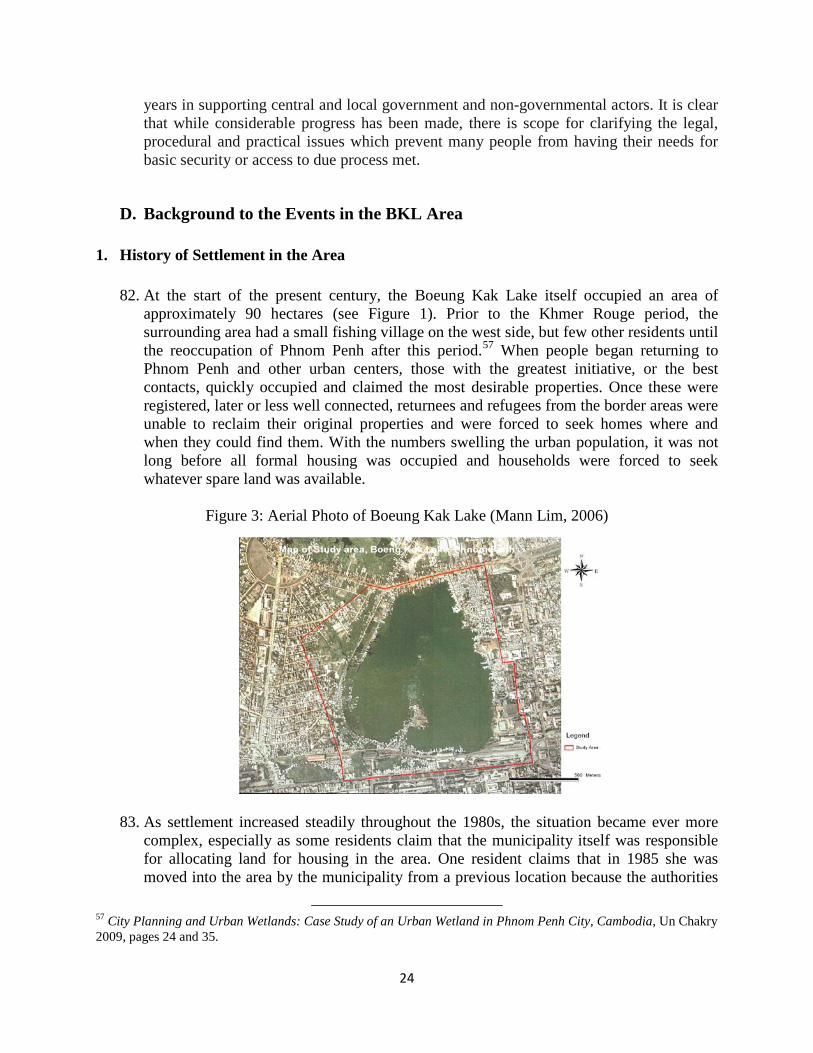
24
years in supporting central and local government and non-governmental actors. It is clear that while considerable progress has been made, there is scope for clarifying the legal, procedural and practical issues which prevent many people from having their needs for basic security or access to due process met.
D. Background to the Events in the BKL Area 1. History of Settlement in the Area
82. At the start of the present century, the Boeung Kak Lake itself occupied an area of
approximately 90 hectares (see Figure 1). Prior to the Khmer Rouge period, the surrounding area had a small fishing village on the west side, but few other residents until the reoccupation of Phnom Penh after this period.57
When people began returning to Phnom Penh and other urban centers, those with the greatest initiative, or the best contacts, quickly occupied and claimed the most desirable properties. Once these were registered, later or less well connected, returnees and refugees from the border areas were unable to reclaim their original properties and were forced to seek homes where and when they could find them. With the numbers swelling the urban population, it was not long before all formal housing was occupied and households were forced to seek whatever spare land was available.
Figure 3: Aerial Photo of Boeung Kak Lake (Mann Lim, 2006)
83. As settlement increased steadily throughout the 1980s, the situation became ever more complex, especially as some residents claim that the municipality itself was responsible for allocating land for housing in the area. One resident claims that in 1985 she was moved into the area by the municipality from a previous location because the authorities
57 City Planning and Urban Wetlands: Case Study of an Urban Wetland in Phnom Penh City, Cambodia, Un Chakry 2009, pages 24 and 35.

25
intended to create an amusement park. She was given a plot and told she could live there “for a while”, but this was over twenty years ago. At first, she just built a small hut, but with time she built more, and now has three buildings in a small complex. She claims that the Prime Minister said that if you live somewhere for five years then you can get a land title. She has all the relevant documentation, even her family book from her old place, but no land title.
84. By 1991, when the country prepared to hold its first general election, most of the land
around the lake had been completely occupied.58
There is anecdotal evidence that political parties seeking votes encouraged the occupation and development of housing in the area and many existing residents claim they were given documents that indicated they were entitled to possess their plots (see Box 1, Chapter 1). Many households claim that they possess documents confirming ownership, while others have documents which they claim were recognized by local authorities during the 1990s through “informal” tenure systems, including the issuance of house numbers, family books, small infrastructure improvements and the official witnessing of land sale contracts.
Picture 1 Dense Housing in BKL Area
85. Surveys undertaken by the Urban Resource Centre in Phnom Penh in late 2001 showed that almost 70 percent of residents wanted to remain in the area and have the opportunity to improve their homes.59
58 Improving Tenure Security for the Urban Poor in Phnom Penh, Cambodia: An analytical case study, Ministry of Land Management, Urban Planning and Construction and the Department for International Development (UK), Khemro, B.H.S. and Payne, G 2004. page 16.
During the late 1990s, the area became a popular location for foreign tourists, especially backpackers on a tight budget, and many guest houses were
59 Study of Relocation of Urban Poor Communities in Phnom Penh. Urban Resource Centre, Phnom Penh 2002.

26
constructed on stilts above the water of the lake with others on the water’s edge. For sums of around US$3-10 a night, guest houses offered a range of accommodation in a congenial environment, despite the mosquitoes, all of which provided a valuable source of income for many residents. The incoming tourists also stimulated the development of secondary services, such as restaurants and bars, as well as construction and local markets. Certainly, by the turn of the century, the area around the lake had been intensely settled, and many properties had been improved by their owners.
2. Land Tenure Categories in the Area
86. Several different tenure categories appear to apply to land in and around the BKL area.
Being a “natural lake”, it is defined in Article 58 of the 1993 Constitution as State property and in Article 15 of the 2001 Land Law as State public land. Unlike rivers, where the riverbank is also defined as State public land, the relevant Prakas60
define the boundary of a lake as the lowest water line at dry season. All land above this is defined as State private land, unless it has public use or public interest. Possessors of land in such areas may therefore be eligible for the granting of formal tenure rights.
87. A section of land to the south of the lake is occupied by the defunct railway lines. While land reserved for railways is legally regarded as State public property, this may not apply since the railways have not functioned for many years and it could therefore be claimed that the land has lost its public interest use and is, therefore, public private land and available for occupation. There is even evidence from the case studies (see Box 2) that the railway authorities themselves encouraged their workers to occupy land in close proximity to the railway lines as early as the early 1980s, so they would be near their place of work. Many such occupants claim to possess documents supporting their claims, indicating that they may be entitled to consideration for titling, especially if they occupied their plots more than five years before the passing of the 2001 Land Law.
88. Finally, other areas around the lake were reportedly used as public parks and even a zoo
at some point after the city was re-occupied from 1979 onwards. While parks would be considered State public land, this would depend upon them being surveyed and registered as such. In the case of the BKL area, specifics on the boundaries of the park and the pattern of settlements are absent and the authorities have not registered the land in the name of the State. This again would indicate that the land in question is State private land until an adjudication process can resolve competing claims by the State, existing possessors, or other claimants.
3. Development Initiatives for the Area
89. In 2003, prospects for long term tenure security and physical upgrading were
dramatically increased for residents in the BKL area and in many other informal settlements in Phnom Penh. Following extensive community development efforts by local NGOs, the Government announced that they were committed to upgrading 500
60 Prakas No 42 DNS.BK dated 10 March 2006 on State Land Identification, Mapping and Classification.

27
informal settlements in Phnom Penh and that this would be undertaken within five years. Part of the BKL area was selected as a case study within this program. These developments created a surge of optimism among residents that they would at last be able to formalize their tenure status and invest what they could to improve their housing and the local environment.
90. Then, in 2004, an international design competition was announced to select the best
proposal for developing the area.61
According to the competition brief, the proposals would give to the lake area a particular “identity” so that Phnom Penh could be restored in its image as the “Pearl of Asia”. The brief also expressed the hope that proposals would provide high standards of planning combining Cambodian identity and international image, restore the original landscape and its recreational use and find alternatives to substandard housing through redevelopment and relocation in areas near the lake.
91. In April 2007, the winning proposals for the international design competition were presented to the Council of Ministers with a suggestion that the employment needs of squatters be considered and that the international railway station be relocated and a new Ministers Council building be constructed next to the lake. Subsequently, the Government authorized the Phnom Penh Municipality to prepare the development project and incorporate the layout plan in the 2020 Master plan which was under preparation.62 Key elements of the winning proposal included: 63
• Prioritizing the Lake’s role as a green lung for the city, and ensuring publicly accessible park areas around the perimeter.
• Establishing water sanitation infrastructure and rehabilitating historical waterways connecting the lake with other parts of the city.
• Plans for the relocation of existing residents to re-blocked areas around the Lake. • The creation of multi-modal linkages between proposed planned developments and
other key elements of the surrounding urban environment (Olympic stadium, Central Market, Vat Phnom area, Toul Kok Telecom tower, Railway station).
92. However, shortly after announcing results of the international design competition for the
BKL area, the Government decided to redevelop the area on a commercial basis in partnership with a private developer, Shukaku Inc. On February 6, 2007, MPP and Shukaku signed a 99 year lease for US$79 million for 133 hectares of land, including the Lake, which is currently being filled in. The Government then approved a Sub-Decree converting this area to State private land.64
61 The competition was jointly managed by a French consultancy firm and the Phnom Penh Municipal Government. For a detailed discussion of the design competition proposals, see Huybrechts, E. 2004. Boeng Kak: Projet d’aménagement urbain. Phnom Penh: Ambassade de France au Cambodge: service de coopération et d’action culturelle.
It became clear that the Government had
62 ‘City buries Pearl of Asia plan’ Phnom Penh Post.(09.03.2007), and ‘In Their Own Words: a Vision 2020’ Phnom Penh Post (03.10.2008) 63 Boeng Kak: Projet d’aménagement urbain (2004). 64 Sub Decree No. 108 S.E., Dated August 7, 2008, on the Transfer of Boeung Kak location from the State’s public
property to the State’s private property.

28
abandoned the winning proposal from the international design competition, known as the ‘Pearl Plan,’ in favor of new partnerships.
4. The Adjudication Process Under the Project
93. On March 31, 2006, the Municipality of Phnom Penh announced that the Sras Chok
commune was designated as an adjudication area for systematic titling under the LMAP.65
This created expectations among residents of the area that their claims would be considered, and when LMAP teams started that month to carry out surveys and adjudication, BKL area residents requested that their individual land claims be recognized.
94. A high proportion of residents claimed to possess documents certified at the district, commune or village levels of the ‘right to occupy’ (often in the form of a signature on a transfer of these rights), or that their family books and utility bills provided evidence of occupancy prior to 2001, as required by the Land Law. Given that the tenure status of the area had not been defined in law, residents pinned their hopes for formalizing their title claims and, in many cases, protecting their livelihoods, on the formal adjudication process of the LMAP project. The Project was suspended by the Bank just a month later, on 6 June, 2006, due to unresolved concerns regarding procurement and governance issues.
95. As per LMAP procedures, a cadastral map was posted for public display (between
January 4 and February 2, 2007). This public display of the adjudication records showed only village boundaries, with owners listed as “unknown”, not those of individual plots or properties, causing serious local concern. Residents say that when they requested that their land claims be investigated, their requests were denied on the grounds that they were living inside a “development zone.” Fears that they would not, after all, be able to formalize their tenure status and enjoy the security to which they felt entitled and had been led to expect, were reinforced on February 6, 2007, when it was announced that the government had signed the Shukaku lease agreement.
96. At a community forum later in February, 2007, some 300 residents met to air their
grievances about the municipality’s decision to lease out the 133 hectare area for commercial development. The commune chief was reported in the press as saying that residents had nothing to panic or worry about as “nobody was going to be forced from the area because of the government’s policy of non-eviction”. 66 On March 13, 2007, Phnom Penh City Hall issued a declaration and informed the public, especially residents of the BKL area, that in the lease agreement signed with Shukaku Inc. there is no provision to relocate residents to relocation sites outside of Phnom Penh. In this declaration the City Hall firmly guaranteed that the Boeung Kak development project would be implemented in consultation with the residents of the area.67
65 Notice of Adjudication from Phnom Penh Municipality to Daun Penh District Governor, No. 83. dated March 31, 2006
66 Cambodia Daily, February 21, 2007, page 17. 67 Declaration of Phnom Penh City Hall dated March 13, 2007.

29
Table 1:Chronology of Events in the BKL Area Related to LMAP
Date Event/Action August 2005 Office of the Council of Ministers informs the Governor of Phnom Penh of the
Government’s ‘in principle’ agreement for Shukaku Inc. to develop the BKL site.
January 3, 2006 Office of Council of Ministers informed the Governor of Phnom Penh of the Government’s agreement for Shukaku Inc. to develop the BKL site.
March 31, 2006 Notice of Phnom Penh as adjudication zone for systematic land titling under LMAP.
May 2006-January 2007
LMAP LRTs carry out survey and adjudication in Sras Chok commune. BKL residents request that their individual land claims be recognized.
June 6, 2006 Suspension of Disbursement. January 4 – February 2, 2007
The public display of the adjudication records showed only village boundaries (with owner listed as “unknown”).
February 5, 2007 Suspension of Disbursement lifted. February 6, 2007 BKL Lease agreement signed between MPP and the private developer. March 13, 2007 Declaration by Phnom Penh City Hall informs residents that they will not be
resettled. December 31, 2007 Extension of Closing Date from December 31, 2007 to December 31, 2009. June 6, 2008 During its supervision mission visit to the BKL area, Management is informed
by the PMO that the BKL area is State public land and therefore residents are ineligible for titles.
July 24, 2008 Letter from Phnom Penh Department of Land Management to MPP describing the boundaries of the “development area”.
August 2008 Residents of the “development area” pressured to resettle. Most tenure-insecure households living in stilt houses on the lake begin to move away.
August 2008 Commencement of lake filling and site development by private developer. August 7, 2008 Re-classification of land to “State private”. January-August 2009 NGOs bring concerns of BKL area to the attention of Bank Management January 24, 2009 Eviction of Dey Krahorm community. April 1-10, 2009 LMAP ERM in Cambodia. April-August, 2009 Bank Management discusses findings of the ERM with Government. April 9, 2009 Letter from NGOs addressed to “the Board of the World Bank Group” attaching
a confidential draft report with list of questions, including reference to potential Inspection Panel request.
July 16, 2009 Bank issues a joint statement with other Development Partners calling for a halt to evictions of Cambodia’s urban poor.
July 17, 2009 Eviction of Group78 community. August 10, 2009 First formal eviction notices to residents in BK villages #2 and #4. August 27-28, 2009 Bank Senior Management visit to Cambodia to discuss LMAP, including a joint
suspension of the Project. September 4, 2009 The Inspection Panel receives the Request for Inspection. September 7, 2009 Government cancels undisbursed balance of LMAP Credit. September 18, 2009 Bank response to cancellation letter in which Management reminds the
Government of their ongoing obligations under the Project

30
5. Forced Evictions from the BKL Area
97. Residents soon started to come under pressure to relocate and to accept one of three
options: i) a lump sum of US$ 8,500 as total compensation for their property; ii) relocate to a dwelling unit at Damnak Troyeung relocation site (more than 20 kilometers outside of the city-centre) with a sum of US$ 500 to cover relocation expenses; or iii) re-housing on-site, providing residents move to Trapeang Anchanh relocation site (also more than 20 kilometers outside the city) for four years while permanent replacement housing is constructed in Boeung Kak.
98. The third option involved moving from individual dwellings on the ground floor to
apartments. This was widely rejected by almost all residents, partly because they did not want to live in apartments above ground as this would entail fewer opportunities to maintain home-based economic enterprises on which many households depended for their livelihoods. Residents also were extremely concerned at moving to a peripheral location for four years, given the negative impact this would have on community cohesion and their incomes. However, an even more pressing reason given by many residents was the complete lack of trust that the developers would honor the offer of re-housing on-site once residents had vacated their present properties. According to some residents, the authorities have actively tried to dissuade people from accepting the third option. It was also reported that the level of cash compensation actually paid varied substantially, many residents receiving less than the US$ 8,500 promised.
99. The only viable options presented to residents were to accept the lump sum and move
away at their own cost or to accept a unit in the relocation settlement. The first caused widespread outrage given the extremely modest sums offered. Anecdotal evidence suggests that the market value of land in the BKL area has risen recently to US$ 3,000 a square meter, indicating that a modest plot of 50 square meters would command a market value of US$ 150,000 excluding the value of any structures, with larger plots worth much more. In this context, US$ 8,000 would not cover the costs of any reasonably similar housing in or near the city, forcing residents into far-flung areas of the country where they often knew nobody and would have to rebuild their lives and livelihoods.
100.Under such conditions, it is not surprising that many households felt they had no
alternative but to accept the third option of a dwelling in the Damnak Troyeung relocation site. Many said they felt unable to protest strongly, or attend demonstrations as they or their spouses worked for the municipality and feared that they could also lose their jobs as well as their homes. Residents reported that the police and company staff harassed them continually in order to weaken resistance and some were forced to demolish their homes themselves, despite being unable to stop crying.
101.During the next year, the situation became increasingly uncertain and a final eviction
notice was issued by the Municipality of Phnom Penh in April 2009. The community

31
filed a complaint with the Cadastral Commission, as well as applying to the Court for an injunction to postpone the eviction until a decision was made on its legality. The court refused to issue an injunction, ruling that the matter was beyond its jurisdiction and should be resolved by the Cadastral Commission.
102.On August 10, 2009, more than 150 families in Boeung Kak Villages 2 and 4 were
issued their first formal eviction notice and subsequently more evictions have taken place. To date, the total number of households evicted from the BKL area is not known, though it is variously estimated at between 950 and 1,200 families with one estimate suggesting up to 2,000 families, and with a further 2,000 under threat. Many households were forced to vacate their lakeside houses when the water level started to rise due to the filling of the lake by the developer (see Box 3 on flooding concerns).
103.Interviews conducted in the relocation settlement, together with visual evidence of phone
numbers on many buildings, revealed that many relocated households both because of the isolation of their new housing units, and the poor quality of construction, which resulted in a serious reduction in already low incomes. As a result, they were selling their units for what they could and returning to the city, where they would either rent or find another vacant area to occupy. Others have found accommodation in other parts of the city, though invariably at the cost of social support from relatives and neighbors.
Picture 2: House Flooded on Boeung Kak Lake
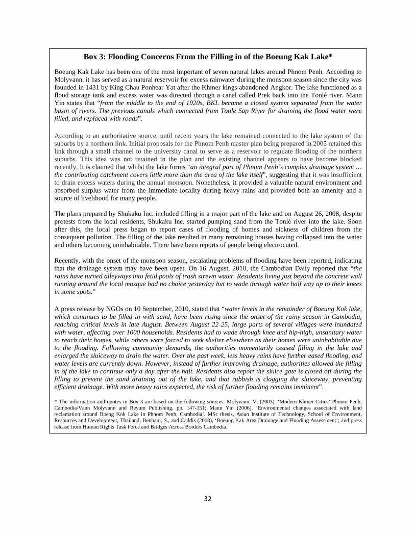
32
Box 3: Flooding Concerns From the Filling in of the Boeung Kak Lake*
Boeung Kak Lake has been one of the most important of seven natural lakes around Phnom Penh. According to Molyvann, it has served as a natural reservoir for excess rainwater during the monsoon season since the city was founded in 1431 by King Chau Ponhear Yat after the Khmer kings abandoned Angkor. The lake functioned as a flood storage tank and excess water was directed through a canal called Prek back into the Tonlé river. Mann Yin states that “from the middle to the end of 1920s, BKL became a closed system separated from the water basin of rivers. The previous canals which connected from Tonle Sap River for draining the flood water were filled, and replaced with roads”. According to an authoritative source, until recent years the lake remained connected to the lake system of the suburbs by a northern link. Initial proposals for the Phnom Penh master plan being prepared in 2005 retained this link through a small channel to the university canal to serve as a reservoir to regulate flooding of the northern suburbs. This idea was not retained in the plan and the existing channel appears to have become blocked recently. It is claimed that whilst the lake forms “an integral part of Phnom Penh’s complex drainage system … the contributing catchment covers little more than the area of the lake itself”, suggesting that it was insufficient to drain excess waters during the annual monsoon. Nonetheless, it provided a valuable natural environment and absorbed surplus water from the immediate locality during heavy rains and provided both an amenity and a source of livelihood for many people. The plans prepared by Shukaku Inc. included filling in a major part of the lake and on August 26, 2008, despite protests from the local residents, Shukaku Inc. started pumping sand from the Tonlé river into the lake. Soon after this, the local press began to report cases of flooding of homes and sickness of children from the consequent pollution. The filling of the lake resulted in many remaining houses having collapsed into the water and others becoming uninhabitable. There have been reports of people being electrocuted. Recently, with the onset of the monsoon season, escalating problems of flooding have been reported, indicating that the drainage system may have been upset. On 16 August, 2010, the Cambodian Daily reported that “the rains have turned alleyways into fetid pools of trash strewn water. Residents living just beyond the concrete wall running around the local mosque had no choice yesterday but to wade through water half way up to their knees in some spots.” A press release by NGOs on 10 September, 2010, stated that “water levels in the remainder of Boeung Kok lake, which continues to be filled in with sand, have been rising since the onset of the rainy season in Cambodia, reaching critical levels in late August. Between August 22-25, large parts of several villages were inundated with water, affecting over 1000 households. Residents had to wade through knee and hip-high, unsanitary water to reach their homes, while others were forced to seek shelter elsewhere as their homes were uninhabitable due to the flooding. Following community demands, the authorities momentarily ceased filling in the lake and enlarged the sluiceway to drain the water. Over the past week, less heavy rains have further eased flooding, and water levels are currently down. However, instead of further improving drainage, authorities allowed the filling in of the lake to continue only a day after the halt. Residents also report the sluice gate is closed off during the filling to prevent the sand draining out of the lake, and that rubbish is clogging the sluiceway, preventing efficient drainage. With more heavy rains expected, the risk of further flooding remains imminent”. * The information and quotes in Box 3 are based on the following sources: Molyvann, V. (2003), ‘Modern Khmer Cities’ Phnom Penh, Cambodia/Vann Molyvann and Reyum Publishing, pp. 147-151; Mann Yin (2006), ‘Environmental changes associated with land reclamation around Boeng Kok Lake in Phnom Penh, Cambodia’. MSc thesis, Asian Institute of Technology, School of Environment, Resources and Development, Thailand; Benham, S., and Caddis (2008), ‘Boeung Kak Area Drainage and Flooding Assessment’; and press release from Human Rights Task Force and Bridges Across Borders Cambodia.

33
Chapter 3: Panel’s Analysis and Findings
A. Overview
104. This Chapter presents the claims of the Requesters, together with the corresponding responses of Bank Management, and the Panel’s analysis and findings on whether the issues of harm totally or partially resulted from the Bank’s lack of compliance with its policies and procedures. The Chapter is organized according to the five main claims of the Requesters, which are summarized below. For each of these five claims, the Panel first summarized the claim and the Management Response, and then present its analysis and findings.
105. The first, claim is that the events in Boeung Kak Lake (BKL) area are linked to the Land
Management and Administration Project (LMAP). Determination of this link is fundamental to the Panel’s investigation and the analysis of other claims of the Requesters. The Panel notes that Bank Management already has acknowledged that this link is present, in agreement with the claim of Requesters.
106. The second claim is that residents of BKL were denied adjudication of their property claims
under LMAP. The Requesters claim that LMAP procedures were not followed and hence people were denied their rights to have their property claims properly investigated and adjudicated. Instead, they contend that their lands have been re-designated to enable development by a private developer, depriving them of the opportunity to claim their property rights, and leading to their forced eviction without due process.
107. The third claim is that residents of BKL were displaced in violation of agreed policies for
involuntary resettlement. The Requesters state that, in violation of the Development Credit Agreement, the Resettlement Policy Framework (RPF) was not applied in the BKL area, thus causing great harm to people evicted from the land. The Requesters claim that the circumstances under which the evictions took place and the conditions of the resettlement sites do not meet the standards provided for in the Bank Policy on Involuntary Resettlement, and that they have suffered - - and remain at great risk of - - serious harm.
108. The fourth claim is that the titling process adopted by LMAP weakens pre-existing tenure
rights of people. The Requesters claim that the Project not only failed to formalize their tenure through land titles but in effect degraded their pre-existing tenure status.
109. Finally, the Requesters claim that not only in BKL area but also other communities in
Project Provinces have experienced forced evictions. They claim that other urban, rural and indigenous communities throughout Cambodia have been unable to access the land titling and/or dispute resolution mechanisms under LMAP, and thus have not been able to secure their land rights under the formal system developed by LMAP.
34
B. Claim That the Events in Boeung Kak Lake Area Are Linked to the Project
1. Requesters’ Claim and Management Response
110. The Requesters claim that “(T)he Boeung Kak community is and has been detrimentally affected by the Land Management and Administration project”, or in other words that there is a direct and formal link between the events that resulted in the evictions of people residing in the BKL area and activities carried out under the Project. Verification of this link is essential for the Panel’s investigation into the other more specific claims of harm raised in the Request, and which are analyzed below in this Chapter.
111. Management in its Response states that “[T]he Sras Chok adjudication area was an area in
which the project was carrying out systematic land titling”68
, and therefore the procedures for systematic adjudication and the environmental and social guidelines agreed for LMAP would apply.
2. Panel Analysis
112. The Panel notes that there is a fundamental disagreement between Bank Management and the Government on linkage between events in the BKL area and LMAP. The Government’s view is that the evictions in the BKL area were not the concern of the Project. As noted above, Bank Management notes that the BKL area is within the adjudication area declared under the Project and as a result events related to land tenure of residents were related to the Project. Development Partners of LMAP agree with the Government and do not recognize a link between the Project and BKL events.
113. For this reason, the Panel has made its own independent assessment of the situation. This
assessment is carried out at three levels. The first level is the principal legal question of whether the BKL area falls within what is defined as “Project Provinces” in the Development Credit Agreement and the PAD, which is discussed in this section. Sections C and D of this Chapter below includes the Panel’s assessment of whether the LMAP procedures provide for excising from systematic adjudication an area such at BKL (Section C) and whether the environmental and social safeguards – the Resettlement Policy Framework in particular – would apply (Section D).
114. Definition of Project Area. The Panel notes that LMAP, according to the Development
Credit Agreement and the PAD, was designed to be implemented in 11 provinces and municipalities, defined as “Project Provinces”, including the Municipality of Phnom Penh, subject to amendment from time to time by agreement between the Borrower and the Bank.69
68 Management Response, p.22.
The BKL area is within the Municipality of Phnom Penh. The Panel further notes that there is no reference or criteria developed in the PAD or the DCA to exclude any areas from the
69 According to Schedule 6 of the Development Credit Agreement and Attachment II to Annex 2 of the PAD, initial Project provinces were Takeo, Phnom Penh, Prey Veng, Kandal, Kampong Speu, Sihanoukville, Kampong Thom, Kampong Cham, Kampot, Siam Reap, and Battambang. The Project area was later expanded to fourteen provinces.

35
definition of “Project Provinces”. In principle, therefore, LMAP, envisaged as a first phase in a national land titling program, could work in any part of Phnom Penh. The PAD stipulated a target of 198,000 parcels to be surveyed and adjudicated in Phnom Penh from 2002 to 2007.70
115. Declaration of BKL as Adjudication Area. The whole of Sras Chok commune, which includes the BKL area and of about 4,250 families including the Requesters, was declared on March 31, 2006 as an adjudication area under LMAP. According to the notice of adjudication, “the project executive team shall carry out systematical adjudication procedures including the demarcation, measurement, and adjudication of land lots … and shall issue land title certificates.”71
The Panel notes that the adjudication notice did not exempt any area within the Sras Chok commune from the adjudication process to be supported by the Project.
116. Based on the above, the Panel finds that the BKL area is within a Project Province and was declared for adjudication under LMAP, hence activities relating to verification of land tenure and ownership subsequent to the notice of adjudication are directly linked to the Project. This is consistent with Management’s position. The Government and other Development Partners supporting LMAP assert that the BKL area is disputed and therefore is excluded from the titling process under LMAP. This issue is discussed further in the section below.
Picture 3: Panel Team Meets with Affected Community in the BKL Area
70 PAD, p. 43. 71 Kingdom of Cambodia, Phnom Penh Municipality, No. 83, March 31, 2006.

36
C. Claim That Residents of Boeung Kak Lake Were Denied Adjudication of Their Property Claims Under the Project
1. Requesters’ Claim and Management Response
117. The Request for Inspection is premised on the understanding that the BKL area was part of
an area declared an adjudication zone for purposes of systematic land registration under the Project and that procedures established under LMAP were to be followed. The Requesters claims that LMAP procedures were not followed and hence people were denied their rights to have their property claims properly investigated and adjudicated.
118. According to the Request, “residents state that when they requested that their land claims
be investigated, their requests were denied on the grounds that they were living inside a ‘development zone.’ This process deviates from the legal procedure developed by the project and adopted by the Royal Government of Cambodia.”72
119. Many residents of the BKL area, according to the Request, “regard themselves as owners of the land”, and possess various documents certifying their long term residence in the area and/or some form of customary ownership. There is an expectation, at least among the majority of the BKL area residents, that a systematic adjudication process under LMAP would result in formalizing such possessory and customary tenure rights.
120. The Requesters claim that the adjudication process that occurred in the Sras Choc commune
“triggered the lifting of the protection granted… against the interference with residents.”73 With respect to the lease agreement between the municipality and the private developer, the Requesters state that “the adjudication process, at a minimum, resulted in a de facto determination of the status of the land to be State-owned.”74
121. The Requesters claim that ““[i]n July 2008, during a regular project supervision mission, World Bank staff visited Sras Choc commune and were made aware of the problems with the adjudication process and the pending eviction of area residents. COHRE is not aware of any remedial action taken by the World Bank following this mission”.
75
122. Management in its Response to the above points concurs with the Requesters, stating that “Management concluded that proper procedures were not followed in the adjudication of the Sras Chok commune”.76
72 Request for Inspection, p. 1.
The residents of the BKL area, according to the Response, were not given an opportunity to present their claims of their possession of land and there is no evidence that a transparent participatory process was carried out to determine the classification of land in the area. Management also notes that “[t]he process that was started
73 Request for Inspection, p. 3. 74 Request for Inspection, p. 3. 75 Request for Inspection, p. 3. 76 Management Response, p. 21.

37
under LMAP with the adjudication of the area was not completed according to the agreed procedures.”77
123. Management states that “[a]ccording to information provided by MLMUPC staff in June 2008, in the villages around BKL only the village boundaries were demarcated during the systematic titling process and no demarcation of individual parcel boundaries was undertaken. Ownership in the area is understood to be shown on cadastral records as “unknown”. This appears to be the classification that is generally used when State Public Land is encountered during the titling process as well as when land is subject to a dispute that cannot be resolved during the titling process at the field level”.78
124. Management acknowledges that in retrospect, “supervision of safeguards and other social measures should have been more robust … and acknowledges that supervision reporting on safeguards issues, up to the most recent safeguards mission in mid-2009, could have been improved.”79
125. In its Response, Management also outlined actions that they planned to take to remedy the situation. Management notes that the relations between the Bank and the Government had been strained by the developments around the BKL events and that the Government had repeatedly stated its disagreement with the linkage between the Project and the BKL evictions. The Government cancelled the Project on September 7, 2009 as a result of this disagreement. Although Bank Management had indicated to the Government that its obligations under the Development Credit Agreement remained until the full payment of the Credit, the Government had continued to disagree on the implementation of the proposed actions by Bank Management.
2. Panel Analysis
(a) Families living in the Boeung Kak Lake Area – Status of their Property Claims 126. As described in earlier Chapters, before the recent evictions and the filling of the Lake,
there were thousands of families living in the Boeung Kak Lake Area in Phnom Penh. A high proportion of these families consider that they have ownership or possessory rights to these lands, and claim to have documents confirming their purchase of the plots and payment of charges. Lands have been held, transferred and inherited, and have enjoyed a degree of social legitimacy and recognition by relevant authorities and users, despite the absence of a nationally formalized system of documentation. Many of the families live outside the high water mark of the lake, some live between the low and high water mark, and some live on stilt-homes within the low water area of the lake.
127. The Panel notes that the legal status of the BKL area is, in key respects, uncertain and
contested. There are several and partly overlapping references to State public and State private land in and around the BKL area, and several different tenure categories appear to
77 Management Response, p. 35. 78 Management Response, p. 20. 79 Management Response, p. 33.

38
apply. The lake itself, being a “natural lake”, is defined in Article 58 of the 1993 Constitution as State property and in Article 15 of the 2001 Land Law as State public land. The relevant regulation (Prakas)80
states that the boundary of a lake is defined as the lowest water line at dry season and there is no law or regulation establishing reserves to lakes. As a result, the land between this line and the highest water line of the rainy season is defined as ‘State private land’, unless it has public use or public interest. On this basis, the Panel notes that all properties built on stilts within the area of the lake itself might be considered to be on State public land.
128. Article 17 of the Land Law states that the property classified/categorized as the private property of the State and of public legal entities may be the subject of sale, exchange, distribution or transfer of rights as it is determined by law. On this basis, the area between the low and high water lines might therefore be eligible for the granting of formal tenure rights to private parties, or public entities.
129. A different stipulation applies in the case of land related to the right-of-way for the railway
line going through the BKL area. Under Article 12 of the 1992 Land Law, land reserved for railways shall be regarded as State public properties. This was repeated in Article 15 of the 2001 Land Law and defined in the Annex to Prakas No. 42 as including all land within 20 meters from the axis within cities, provincial towns and populated areas.81
There is anecdotal evidence from the case studies (see Chapter 1, Box 1) that the railway authorities themselves encouraged their workers to occupy land in close proximity to the railway lines as early as the early 1980s so they would be near their place of work. Many such occupants, who are among the people and families represented in the Request to the Inspection Panel, claim to possess documents supporting their claims, indicating that they may be entitled to consideration for titling, in particular those who occupied their plots more than five years before the passing of the 2001 Land Law.
130. Finally, other areas around the lake were reportedly used as public parks and even a zoo at some point after the city was re-occupied from 1979 onwards. Public parks and gardens are defined in the 2001 Land Law as State public land, so that any occupancy of such lands cannot be considered legal.82
The Panel notes that no parks remain and it is not clear where the borders were located. Since such areas have not been surveyed and registered in the name of the State, and moreover have lost their public use function as parks, it could be argued that the area is State private land. In such cases, people and families who have possessed and occupied such lands in accordance with provisions in the 2001 Land Law may also be eligible to have their claims for ownership considered.
131. It is the Panel’s view that parts of the BKL area may be eligible for consideration of titling for private ownership under the adjudication procedures of LMAP. As noted previously, the BKL area was declared to be an area for adjudication under the Project in 2006.
80 Prakas No 42 DNS.BK dated 10 March 2006 on State Land Identification, Mapping and Classification. 81 Prakas No. 42 DNS.BK dated 10 March 2006, on ‘State Land Identification, mapping and Classification’ page 8. 82 2001 Land Law, Article 15.

39
(b) Re-classification of Lands and Lease Agreement with Private Developer. 132. The Panel learned that during Project implementation, the Government classified the land
areas in and around BKL, including areas inhabited by the families of the Requesters, to be “State public land.” The Panel further learned that plans were separately underway to lease these same lands to a private developer. The Panel examined these actions in light of Project provisions designed to ensure the proper consideration of the tenure claims of the families living on these lands, in accordance with Bank policy.
133. For the purposes of this examination, a brief review of the relevant legal context is
important. Article 15 of the 2001 Land Law lists the types of property that fall within the public property of the State. This includes any property that has a natural origin, such as courses of navigable or floatable water and natural lakes. As a natural lake, Boeung Kak lake is therefore by definition State public land, though the area around the lake remains undefined. According to Article 16, State public land may be subject to temporary occupation or use, though Article 18 of Sub-Decree 129 states that leasing of State public Land must not exceed 15 years and must not damage the property or change its function in providing public services.83 Article 16 of the Land Law also states that “[W]hen State public properties lose their public interest use, they can be listed as private properties of the State by law on transferring of State public property to State private property”. 84
134. However, Article 3(c) of the Sub-Decree on State Land Management85 requires that “[e]ach piece of State land shall be registered in the Land Register as public or private land of the State” and Article 13 refers to reclassification as “changing the status of land already registered as State public or State private land.” Article 4 of the Royal Decree86 also states that “[t]ransferring public properties of the State and legal public entities can only involve properties already inventoried as State public properties.” Thus, land can only be reclassified from State public to State private after it has first been registered as State land in the land registry “[u]nless otherwise provided by law.” 87
Such reclassification must also be in accordance with Article 16 of the Land Law. The Panel notes that a key objective of the LMAP was to undertake such registration.
135. According to the Management Response, during the Supervision mission in June 2008, the Bank was informed that the Municipality of Phnom Penh (MPP) claimed that the BKL area was ‘State public land’ and as a result, the households in the area were excluded from titling because it was not possible under the Land Law to assert private claims of legal possession to State public land. Furthermore, Management states that it has “not received any evidence to support MPP’s assertion that the BKL area was State Public Land.”88
83 Sub-Decree 129 on Rules and Procedure on Reclassification of State Public Properties and Public Entities, Articles 16 and 18. 84 2001 Land Law, Article 16. 85 Sub-Decree 118, (2005) Sub-Decree on State Land Management, 07 October. 86 Royal Decree on ‘Principles and Transitional Provisions on Transferring Public Properties of the State and Public Legal Entities’ 03 August, 2006. 87 ibid, Article 14. 88 Management Response, p. 19.

40
136. According to the Management Response, only village boundaries were demarcated by LMAP. Public display of the adjudication records showed ownership in the area as “unknown” on the cadastral map prepared by the Administrative Commission under MLMUPC. Management notes that this appears to be the classification generally used for State public land and for land subject to a dispute that cannot be resolved at the field level during the titling process.89
137. As noted Chapter 2 of this Report, although the BKL area was claimed to be State public land by the Government and as a result the residents were told they were ineligible for any property rights, plans for private development of the BKL area were well underway prior to its declaration as an adjudication area under LMAP. In August 2005, as early as seven months prior to the declaration of the adjudication of BKL area in March 2006, the Office of the Council of Ministers informed the Governor of Phnom Penh the Government’s ‘in principle’ agreement for Shukaku Inc. to develop the BKL site. The letter also refers to the Government’s decision to create a working group “to conduct an in depth study on the master plan, which has been studied by the technicians and the Company’s Development Plan”, and the need to “take action to resolve the squatter problems step by step that the company had studied and conduct with past experience.”90
Picture 4: Sand Filling Boeung Kak Lake
138. On January 3, 2006, the Office of Council of Ministers informed the Governor of Phnom Penh, the Government’s agreement “for Shukaku Inc. to develop Boeung Kak by reserving 10 Hectares of the lake” and “for the City Hall to conduct study with the company and with its past experience in resolving step by step the squatters and lake filling for development purpose.”91 On January 30, 2007, the Prime Minister authorized the Governor of Phnom Penh to sign the lease agreement with Shukaku Inc.92
89 Management Response, p. 21.
The 99 year lease agreement between
90 Letter Number 1274. S.Ch.N. of the Office of Council of Ministers, dated August 5, 2005, from the Deputy Prime Minister; Minister in charge of Office of Council of Minister to H.E. Governor of Phnom Penh City. 91 Letter Number 01 S.Ch.N. of the Office of Council of Ministers, dated January 3, 2006, from the Deputy Prime Minister; Minister in charge of Office of Council of Minister to H.E. Governor of Phnom Penh City.. 92 Authorization Number 10 S.Br.T. of Royal Government of Cambodia dated January 30, 2007.

41
the Municipality of Phnom Penh and the private developer, Shukaku Inc, was signed on February 6, 2007, almost one year after the declaration of BKL as an adjudication area under LMAP. On August 7, 2008, Government issued a Sub-Decree to convert the area (including the lake itself) from State public land to State private land.93
139. NGOs working on land issues in Cambodia, and supporting the Request, question the validity of the transfer of BKL from State public to State private property for several reasons. They state that BKL, being a natural lake is, by definition State public property because of its natural origin, and therefore should not be subject to transfer to State private property. In addition, they note that State public land can only be reclassified if it has lost its public use, and BKL, being one of Phnom Penh’s biggest natural rainwater retention systems, has not lost its public purpose.94
140. The Panel notes that through leasing BKL for private development and reclassifying BKL area from State public property to State private property, Government effectively determined that land around the lake, and even the lake itself, lost its public interest use and can be subject to private property rights. By designating the land as State private, the residents or possessors of land in the area could reasonably consider themselves as entitled to having their claims adjudicated.
141. The Panel concurs with Management that residents in the BKL area were denied
access to a due process of adjudication of their property claims. The Panel finds that residents of the BKL area were justified in expecting that their claims to land were eligible for consideration under systematic land titling, and furthermore that all land claims in the commune were to be adjudicated in accordance with the procedures and processes for adjudication of property claims, agreed between the Government, Bank and Development Partners supporting LMAP.
(c) Excision of the BKL area following declaration of adjudication under LMAP
142. A related issue considered by the Panel is whether the excision of the BKL area from
LMAP during Project implementation was consistent with Project design and obligations under the Project.
143. The Panel notes that both the Ministry of Land Management, Urban Planning and
Construction (MLMUPC) and the Development Partners hold the view that the process followed in the BKL area did not violate the Borrower’s obligations under the Development Credit Agreement. They noted to the Panel that the BKL area was excised from the adjudication process because of its disputed status, and that titles, including to the State, were therefore not issued. They based their argument on the PAD statement that “[t]he project will not title lands in areas where disputes are likely until agreements are reached on the status of the land.”95
93 Sub-Decree No. 108 S.E., on the Transfer of Boeung Kak location from the State’s public property to the State’s private property, dated August 7, 2008.
The Requesters and NGOs claim, on the other hand, that the exclusion of
94 Untitled, BABSEA, COHRE, JRS, 2009. P. 60, 61. 95 PAD, p. 24.

42
“disputed” or “unclear” areas from systematic titling allowed provincial or municipal authorities, who are in charge of selecting adjudication zones, to excise areas that are sought after by powerful people and foreign investors. 96
144. The Panel divided its analysis of this issue into four inter-related parts: Project adjudication procedures, Project approach to disputed land, Project approach to informal settlements, and Project approach to State land management. Each part is discussed below.
• Project Adjudication Procedures
145. The Project Implementation Manual explains ‘adjudication’ as a process, “which defines the
existing right in a land parcel finally and officially without altering existing rights in a land parcel nor creating new rights.” It also “determines who may exercise those rights as well as any limitation upon those rights in the respect of the laws and regulations in force … [t]he result of adjudication is a complete land record that is certain, final and guaranteed by the State.” 97
146. Sub-decree 46 “On the Procedures to establish Cadastral Index Map and Land Register” establishes the legal procedures for systematic land titling under LMAP. Article 2 which covers declaration of an adjudication area says that “[p]rovincial/Municipal Governor shall declare an area and boundaries as an adjudication area. Any decision made under this article shall define the location and the limits of adjudication area either by means of a map or by a description, or by both.”98
It is the Panel’s understanding that it was established practice to announce adjudication areas following commune boundaries, although Sub-decree 46 does not specify anything to this effect.
147. Once an area has been declared as an adjudication area, the Sub-decree specifies a procedure whereby claims to all parcels in the area shall be subject to adjudication. Article 9 states: “The Demarcation Officer shall, subject to directions issued by the Field Manager, investigate all available documents, evidence and other written and oral information concerning the rights related to each parcel in the adjudication area and record these rights to parcel form”99
(emphasis added).
148. The Panel notes that Sub-Decree 46 and adjudication procedures developed under LMAP do not include any provisions for excising portions of a declared adjudication area, once the process has legally started. Any competing claims to land must be resolved in the process, or be referred to the National Cadastral Commission or the court for resolution (ref. Articles 12 and 14 of Sub-decree 46) 100
96It is claimed in a recent study that the exclusion of “disputed” or “unclear” areas from systematic titling “allowed provincial or municipal authorities, who are in charge of selecting adjudication zones, to excise areas that are sought after by powerful people and foreign investors.” ‘Land Titling in Cambodia: Formalizing Inequality’ Bridges Across Borders Cambodia | A Year in Review 2009 Bugalski, N and Pred, D. (2009).
. According to the Requesters and people
97 Project Implementation Manual, 1st Part: Adjudication and 2nd Part: Public Display. 98 Royal Government No. 46 ANK.BK/May 31, 2002, Article 2. 99 Sub Decree No. 46 on the procedures to establish Cadastral Index Map and Land Register, May 31, 2002, Article 9. 100 During the investigation, the only document the Panel found referring to exclusion from an adjudication area relates to Tonle Basac commune, dated October 6, 2009. This document from MLMUPC to the Chair of the

43
interviewed by the Panel, property claims from residents of the BKL area were never considered. This is also the understanding of Management.101
• Project Approach to Disputed Land 149. There are two references in the PAD to situations where titles might not be issued under the
Project. The first (discussed here) relates to disputed land, the second one (discussed in the following section) relates to informal settlements.
150. In the PAD, the problem of growing conflict over land is central when outlining the
strategic context for the Project. There are several reasons, and “[c]hief among them is uncertainty about where boundaries of land under the control of various State entities or private individuals lie.”102 The PAD argues that “land is becoming progressively more concentrated in the hands of influential and powerful people or entities and those who can afford informal payments, especially in regions with potential for tourism, logging, industrial or urban development.“103 When describing the “strategic choices” underpinning project design the PAD mentions “phased implementation” (the Project is envisaged as the first 5-year phase of a 10-15 years national program), “charging fees for property titles”, and “supporting NGOs to execute activities related to community participation”.104
151. The Panel notes that there is no reference in this part of the PAD or the DCA to a strategic decision to avoid disputed land. On the contrary, the Panel reads the introductory part of the PAD as emphasizing the need for reducing the level of conflict over land through processes of adjudication and dispute resolution. The Panel also notes that no definition of disputed land is given in the PAD, DCA, or any other Project document. Similarly, areas of “unclear status” are also not defined in the PAD, DCA, or other documents.
152. The section on “Possible Controversial Aspects” of the PAD stated that:
Classifying land and demarcating the boundaries between the public and private domains, and, for land in the public domain, tracts under the control of various government entities will often be difficult and may increase disputes in the short-run. The project will not title lands in areas where disputes are likely until agreements are reached on the status of the land. The project will support a systematic public consultation process to help build consensus for decisions and will ensure continuous discussions and consultations with NGOs and civil society. It is anticipated that some
Administrative Committee of Phnom Penh refers to exclusion of seven areas from systematic titling. The reasons given for excluding these areas was that the areas were “deemed to be complicated for the systematic titling process.” The notice states that “in some areas people came in to occupy and built temporary residence on state land (Ministry of Agriculture, Chamka Morn Villa Complex); in some others, people built temporary residence on land belonging to pagodas; while in some other areas, people came in to occupy and reside … on the upper and lower floors (Boulding block). With regard to [two of the areas] there is a notification issued by the government permitting companies to buy the land according to the agreed price.” 101 Management Response, p.19. 102 PAD, p.5. 103 PAD, p.5. 104 PAD, p. 8.

44
land now nominally under State control (about 80 percent of the total) will be released to the private domain. This will free government resources to better manage the lands that remain under its control.105
[emphasis added]
153. This statement in the PAD, although unclear, seems to be consistent with the overall project design and its approach to disputed land, and the fact that titling under the Project would be dependent on successful dispute resolution. Considering that the process of delimiting boundaries between public and private land would not always be smooth, the Project envisaged involving systematic public consultation processes. The Project, as noted in the above paragraph, hoped to help build consensus for decisions and to ensure continued discussions and consultations with NGOs and civil society, and included a component aimed at strengthening mechanisms for dispute resolution (Component 4). Furthermore the Project also included support for land classification and delimitation of boundaries between the public and private domains, and creation of capacity for land management (Component 5). Some in Bank Management also confirmed to the Panel that the language in the PAD was not intended to provide a basis to exclude, from the Project, areas where land titles were in dispute; indeed, the overall Project design and existence of the adjudication process pointed quite to the contrary.
154. However, the interpretation of the above noted paragraph in the PAD, particularly the
statement regarding the disputed lands, seems to have changed over the course of Project implementation. The current interpretation, reinforced by the Project’s performance target of issuing one million titles, is simply that the Project will not title lands in areas where disputes are likely. This view seems to be widely shared among the Government, Development Partners, Project staff, and consultants. In meetings with the Panel, it was referred by some as “going for the low-hanging fruits”. However, the Panel notes that there is no reference in any key project documents to principles for determining ‘areas where disputes are likely’ or procedures for how to excise such areas from systematic land titling.
• Project Approach to Informal Settlements
155. The second reference to situations where titles might not be issued is found in a paragraph
titled “Informal Settlers” specifying the Project’s approach in situations where there are “informal settlers including squatters”. In these situations, according to the PAD, the Project “will not issue titles where there is no agreement to allocate the land to informal settlers or through land sharing and/or relocation programs (emphasis in original).”106 The Management Response states that the PAD “made it clear that Project-supported titling processes would not issue titles to “informal” settlers or “squatters” on State land.”107
156. The Panel notes that the decision not to support regularization of informal settlements under the project is not accompanied, in the PAD or the Development Credit Agreement, with a formal definition of the terms ‘informal settler’, ‘informal settlement’, or ‘squatter’. The terms also appear not to have a formal definition in
105 PAD, p. 24. 106 PAD, p.20. 107 Management Response, p. 12.
45
Cambodian law or policy. A recent draft National Housing Policy (March 2010) makes reference to the need for a “[p]rocedure for resolving temporary settlement on illegally occupied land in municipal and urban areas”. It is the Panel’s understanding that these terms in the PAD refer to people occupying State public land who do not qualify for the issuance of title under the 2001 Land Law. In other words, the Project was not envisaged as a program for regularizing informal settlements on State public lands; titling in such areas would only occur if Government had first elected to provide the land to the informal settlers and had taken steps to legalize their occupation. On the other hand, it is the Panel’s understanding that the primary objective of the Project was, in the absence of clear land classification boundaries, to determine the legality of any claims to land, including by people who prima facie seem to be illegally occupying the land, through an adjudication process.
157. Although the Project did not envisage issuing titles to informal settlers (unless there was a
specific agreement to allocate land), it is the Panel’s understanding that this would not mean a restriction for informal settlers – however defined – to have their land claims adjudicated. The Panel notes that with the destruction of all land records during the Khmer Rouge period and the lack of a functioning land administration system in the tumultuous years of re-occupation of Phnom Penh that followed, State departments and agencies, as well as individuals, lack formal titles to land. For this reason, LMAP was designed to support advancement in classification and mapping of State land in order to strengthen land tenure security and land markets, and prevent or resolve land disputes.
158. The Panel also notes a reference in the PAD to the program by UNCHS/UNDP and other development partners to provide security of tenure in informal settlements. It acknowledges that “[n]either the World Bank nor the Ministry of Land has the comparative advantage in dealing with informal settlers and squatters. It is better for the Project to support the development groups currently working in this field”.108 Attachment II to the PAD also states that, following discussions with donors and NGOs implementing the Urban Poverty Reduction Project, “there was agreement that the Project will coordinate closely with the development groups in the informal settlement program”.109
Despite the statement in the PAD to coordinate closely with the UNCHS/UNDP program dealing with informal settlers and squatters, the Panel was unable to obtain any evidence during its investigation that any such coordination or support was provided by the Project to the UNCHS/UNDP program prior to it being ended in 2004. Nor was any evidence obtained of a change in approach towards informal settlements following this date.
• Project Approach to State Land Management 159. The LMAP design included State land management as component 5 of the Project. This
component envisaged developing procedures to define land classification, to acquire aerial photography and remote sensing imagery, and to prepare, for each Project Province, land classification maps showing the boundaries of forests, protected areas, and land under private, public and concessionary use. Since about 80 percent of land in Cambodia was under State control without established boundaries between public and private domains of land,
108 PAD, p. 20. 109 PAD, Attachment II, p. 87.

46
State land management was a critical component of LMAP. However, there was limited progress in the implementation of this component. It was rated ‘unsatisfactory’ and most of the unimplemented activities were proposed to be cancelled in January 2009.110
160. In its Response, Management acknowledges that this component was added to the Project at a late stage during Project preparation and lacked details compared to other components of the Project. Management Response notes that, “the Project design, while flagging the importance of the issue and its riskiness, underestimated the complexity and politically fraught nature of State land management.” Management Response adds that “... the lack of detailed plan for inter-ministerial and inter-agency coordination, given the multi-faceted nature of the land management agenda as well as its political and technical complexity was a flaw in Project design.”111
161. Governance issues and difficulty in reaching agreement among Government agencies and other stakeholders on the process of land classification were identified among critical risks of LMAP. As noted above, the “Possible Controversial Aspects” section of the PAD stated that “classifying land and demarcating the boundaries between the public and private domains, and, for land in the public domain, tracts under the control of various government entities will often be difficult…”112 The PAD suggested that the risk of disagreement during land classification could be overcome by supporting a consultation process and technical assistance to the council of land policy to build consensus among government agencies. Management Response notes that “a more detailed analysis of the political economy context would likely have identified this view as overly optimistic…”113
162. The Enhanced Review Mission (ERM) noted the absence of an official mapping of State land and stated that “this is a real source of concern for those under threat of eviction because absent these maps, the relevant municipal authority can exclude from titling any portion of land surveyed and proposed for adjudication by the cadastre team and therefore titling it, implicitly, in the name of State.”114
ERM identified the absence of State land mapping as an important shortcoming for LMAP to succeed and help solve land conflicts and security of tenure.
163. The Panel concurs with the ERM’s findings that the lack of State land mapping has contributed to de facto determination of State land (public and private) without applying the LMAP adjudication process.
3. Compliance Findings 164. The Panel’s analysis focuses on whether Bank Management has complied with relevant
Bank operational policies and procedures in relation to this Project, and if not, whether such non-compliance has contributed to the harm alleged in the Request. This analysis is divided
110 Aide Memoire (11th Supervision Mission, January 2009), pages 11 and 12. 111 MR, para. 68, p. 31. 112 PAD, p. 24. 113 MR, para. 34, p. 12. 114 Enhanced Review Mission, 2009, para 15, page 6.

47
into two aspects of the Management’s involvement with the Project, namely design and appraisal, and supervision.
165. Design and Appraisal. As noted by Bank Management, LMAP, by design, was a complex
and ambitious undertaking that was meant to deal simultaneously with multiple issues in land management and administration following the destruction that accompanied the period of Khmer Rouge rule. The overall goals of the Project were to reduce poverty, promote social stability, and stimulate economic development. The specific objectives of the Project were to improve land tenure security and promote the development of efficient land markets. To achieve these objectives, the Project included components to develop land policies and a regulatory framework, support institutional capacity building, establish a land registration system, strengthen dispute resolution mechanisms, classify land for different land use arrangements, and carry out systematic and sporadic land titling.115
166. OMS 2.20 on Project Appraisal, paragraph 17, specifies that “the appraisal normally includes assessing the sensitivity of the projects viability to changes in the key parameters of the project, together with the judgment on the likely variation from basic parameters” and adds that “[f]or projects with marginal returns or large risks, further clarification of the risks through formal risk analysis is also desirable. Where necessary, the appraisal also includes recommendation regarding precautionary measures which should be undertaken to reduce the risks.” While noting that determining the extent and depth of risk analysis always represents a difficult judgment, the Panel is of the view that Management in this Project did not adequately address risks in the project design.
167. The risk analysis contained in the PAD rated the overall risk as “substantial”.116
There was, according to the PAD, a “high” risk that governance in Cambodia would not improve which would affect the ability of the project to reach its objectives. Furthermore, the risks were “substantial” that Government would lack commitment to ensuring a dispute resolution mechanism function efficiently and fairly, and that Government entities and other stakeholders would not be able to reach agreement on the process of land classification.
168. The Social Assessment prepared for the Project showed that disputes over land were growing as land values rose, especially in areas with potential for development, such as lands near roads and lands in or near urban areas or market centers. The assessment continued to note the difficulty that ordinary people faced in defending themselves successfully against powerful parties using formal dispute resolution mechanisms.
169. In the Panel’s view the design of the Project acknowledges these challenges by way of an
integrated approach that involves systematic land titling, conflict resolution and State land classification and management. The design of the project, however, does not adequately reflect the appreciation of the risks involved. One issue is of particular relevance to the Requesters claim, namely risks associated with overlapping claims to land by public agencies and individuals. As noted above, this problem was clearly noted in the PAD, but the document does not clearly identify the process by which to handle these risks. To the
115 PAD, p. 8. 116 PAD, p. 24.

48
contrary, the Panel finds that the Project design is not clear what will be the Project’s strategy both with respect to determining areas for systematic land titling (i.e. adjudication areas) and dealing with disputes between State entities and private individuals during the adjudication process.
170. In addition, the PAD statement regarding disputed lands,117
without any definition of the term and the process to be followed, led to significant confusion among different stakeholders during Project implementation. Furthermore, even though it was known that the boundaries of State public land were undefined, the Project design excluded informal settlers/squatters from receiving land titles, unless approved by the Government, and left the issue to be addressed by the UNCHS (UN HABITAT) program. The Panel finds that these ambiguities in the Project design in part contributed to the harm that Requesters are facing. Consequently, the Panel finds that although risks associated with the Project were properly identified, Management did not comply with OMS 2.20 on Project Appraisal with respect to addressing these risks.
171. Supervision. During the Project’s early years from 2002 to mid 2005, supervision reports show that although Project implementation was slow and problems started to emerge for the implementation of certain components of the Project, such as dispute resolution and State land mapping, the overall Project rating was satisfactory. However, after mid 2005, the implementation of different components of the Project consistently became uneven. Following the suspension of the Project from June 2006 to February 2007 due to fiduciary problems, the “General Review of Project Status” (the General Review) which was done as part of the 9th Supervision Mission (May 30-June 8, 2007), clearly stated there were problems with Project implementation.
172. The General Review noted that while there was a strong Management focus “on a limited
number of core, ‘headline’ elements of the Project,” there was “lack of effective management response in recognizing and addressing” problems that have been consistently identified during the course of the Project. The General Review emphasized the implementation of LMAP as a complex integrated system, of which all parts have to be “effectively operational, and thus of which all parts are core.”118
The results for State land management were deemed “unsatisfactory” and “moderately unsatisfactory” for dispute resolution. Dispute resolution was lacking especially for complex multi-party cases, and those involving the State or “powerful individuals.”
173. The General Review noted the need to actively address the following issues under LMAP: “the backlog of undistributed titles; the relative lack of progress in urban areas; the institutional restructuring of MLMUPC; the low level of subsequent registrations; the level of outstanding disputes before the Cadastral Commission; and, appropriate levels of good governance.” In addition, the General Review noted that the Project must actively address “socio-economic baseline studies and subsequent impact studies, other monitoring studies, and feedback from civil society which will provide essential information for informed
117 PAD, p. 24 118 “General Review of Project Status”, Annex 7 of Project Review and Ninth Multi-Donor Supervision Mission, May 30-June 8, 2007

49
management decision-making as the project and programme progress.” Despite these recommendations, the Project implementation progressed, and the Project implementation period (the Project Closing Date) was extended.
174. Even before the above noted review, a February 2006 “Independent Review of
Transparency and Accountability Issues” (the Independent Review) in the Project noted problems with land titling and the LMAP project. According to this review, “at least a fifth of households (19.6%) in 13 of the adjudication areas visited are being adversely affected by the systematic land titling process, usually through the refusal to register land in household possession or use.”119 Households interviewed for the Independent Review stated that “the LMAP demarcation teams flatly refused to register either their ‘claim or possessionary rights’ to some of ‘their’ land due to it being ‘State land’.”120
175. The Independent Review also noted the lack of information provided to households regarding the systematic land titling process and the procedures involved. According to the Independent Review, “the proposed beneficiaries; do not know ‘the who? what? where? when? why? how much? and by/for whom?’ issues related to the systematic land titling.”121 Additionally, the Independent Review stated that the households are not being adequately informed of “the potential issues of compensation/resettlement when the lands they claimed are disputed by the State.”122 The Independent Review claimed that information was not being made available on residents’ possible rights to compensation “as outlined in the RGC agreed social safeguards to be applied in the LMAP project.”123
176. When the BKL area was declared an adjudication area under the Project in March 2006, the Project had been effectively operating for four years. This represents a fairly long period for testing the LMAP design and procedures, and experiencing particular bottlenecks and risks. OP 13.05 states that Project supervision shall “identify problems promptly as they arise during implementation and recommend to the borrower ways to resolve them”; “recommend changes in project design, as appropriate, as the project evolves or circumstances change”; and “identify the key risks to project sustainability and recommend appropriate risk management strategies and actions to the borrower”.
177. The Panel finds that Management’s supervision of the Project for several years
overlooked the critical issue of adjudicating private claims on land claimed by the State. This failure of Management, in the Panel’s view, contributed to the events in the BKL area and the harm that Requesters are facing. Management’s supervision of this critical issue did not meet the requirements of OP/BP 13.05.
178. The Sras Chok Commune was declared an adjudication area during the suspension of the
Project. Following the lifting of suspension in February 2007, a supervision mission visited
119 Independent Review of Transparency and Accountability Issues in the Systematic Land Titling Field Systems and Procedures of the Land Management Administration Project (LMAP) Adjudication Areas, Declan O’Leary. February 2006, p. ii. 120 Independent Review, P. 14. 121 Independent Review, p. 16. 122 independent Review, p. 16. 123 Independent Review, p. iii.
50
the BKL area (Sras Chok Commune) in June 2008. During this visit, the Project Management Office informed the Bank and the Development Partners that BKL was State public land, and therefore residents were not eligible to receive titles. The Panel notes that Management was not aware of adjudication areas even within Phnom Penh. The Panel also notes that Management did not raise any concerns with the Government authorities regarding how to proceed to settle the dispute around the BKL area, which involved more than 4,000 families, nor did it raise concerns about the application of the Resettlement Policy Framework.
179. About six months after this supervision mission, in January 2009, armed police forcibly
evicted roughly 400 families from the Dey Krahom community. At this point, NGOs started a dialogue with Bank Management and also raised concerns regarding another threat of eviction in another community, Group 78. As can be seen in the chronology of events in Chapter 2 of this Report, it took almost four years after the declaration of the Sras Chok Commune as an adjudication area, for Bank Management to realize the harm that the residents faced and the gravity of the situation.
180. The Panel finds that Management failed to act on information when the problems
arising in the BKL area were first brought to its attention, and that Management’s supervision in this respect was not consistent with the requirements of OP/BP 13.05.
181. From early 2009, when information about a possible request to the Panel surfaced, the Bank
seriously attempted to engage Government in an attempt to revisit the BKL case. Throughout January and February 2009, the Task Team engaged in dialogue with NGOs to discuss their concerns about the Project. Management states that once it realized there was “an apparent acceleration of evictions” it “reacted promptly.” Management took many actions to address the concerns raised. Among these actions, according to the Management Response, “Management met on several occasions with higher levels in Government and issued several letters to the Government asking it to place a temporary moratorium on evictions.”124
182. From March 30 to April 12, 2009, Management sent an Enhanced Review Mission for the Project. The Report for the ERM again called for a temporary moratorium on evictions. The Bank also took the lead in preparing and issuing a public statement with ten donors on July 16, 2009, which, according to Management, was subsequently endorsed by more than sixty Cambodian and International NGOs. The Bank also set up a safeguards mission during August 3-5, 2009, and the Regional Vice President visited Phnom Penh on August 27-28 to meet with senior government officials.125
183. The Panel finds that Management’s recent supervision of the Project, on issues raised by the Request, complies with Bank Policy on Project Supervision OP/BP 13.05. However, the Panel concurs with the Requesters’ assessment that “it is evident that the actions taken by the Bank Management were too late to prevent the harms now being done.”
124 Management Response, p. 24 125 Management Response, p. 25

51
D. Claim That Residents of the Boeung Kak Lake Area Were Displaced in Violation of Agreed Policies for Involuntary Resettlement
1. Requester’s Claim and Management Response
184. The Requesters claim that (by September 2009) “[m]ore than 900 families from Boeung Kak have already been cleared from the area without their land rights being properly adjudicated. In the absence of any legal protections, these families accepted inadequate compensation under conditions of duress.”126
According to the Request, on 10 August 2009, more than 150 households in the BKL area were issued their first eviction notice. They were offered one of three compensation options to be accepted within a one-week deadline:
• a lump sum of US$ 8,500, • a dwelling in a resettlement site some 20 km from the BKL area (Damnak Troyeung), or • onsite housing in the BKL area, which would require temporary relocation for four years
awaiting completion of new houses in the BKL area (the offer included temporary relocation to another site also about 20 km outside the city centre – Trapeang Anchanh).
185. The Requesters note that the Development Credit Agreement (DCA) had envisaged the
possibility that evictions could take place under the Project and, as a result, provided for the application of the Environmental and Social Guidelines which included a Resettlement Policy Framework (RPF). The Requesters state that, in violation of the DCA, the RPF was not applied in the BKL area, thus causing great harm to people evicted from the land. The Requesters claim that the circumstances under which the evictions took place and the conditions of the resettlement sites do not meet the standards provided for in the Bank policy on involuntary resettlement.
186. Management in its Response confirms that the DCA required the application of the RPF in
the event of evictions from State land under the Project component providing for systematic and sporadic titling.127 Management states that the titling component of the Project, due to financial, institutional, technological and human capacity constraints, was designed to be implemented sequentially on selected adjudications areas first, and then moving on to other locations once the former were completed. It adds that the RPF application was supposed to follow the same sequence. Therefore, Management states, it was “clearly albeit implicitly contemplated” that there would be areas where the Project would not be active and that the RPF would not apply.128
187. With respect to the BKL area specifically, Management concurs with the Requesters that the Resettlement Policy Framework should have been applied to the displacements that occurred in the Sras Chok commune. As specified in the DCA, the RPF was to be applied in the event of evictions from State land as a result of project activities, and a site specific resettlement action plan should have been prepared for review and approval by the Bank. Management agrees with the Requesters that, although it was still not clear whether the BKL
126 Request for Inspection, p.5 127 The objectives and triggers of the RPF are described and analyzed in the sections below. 128 Management Response, ¶ 32.

52
area had been titled to the State, the lease that the Government granted to a private developer on the land in 2007 constituted a de facto determination that the land was State land. In the view of Management: “[t]o exclude the application of the RPF to evictions in a Project adjudication area because the adjudication process was apparently not followed to its conclusion and no formal title was issued in the name of the State, would be contrary to the intentions underlying the development of the RPF, as set out in the DCA.”129
188. Management in its Response refers to the position of the Government, which argues that the BKL area was not a concern of the Project because the BKL land was not titled to the State by LMAP. While Management objects to this argument for the reasons noted in the previous paragraph, it also acknowledges that “a lack of specificity in the Project documents and the apparent absence of detailed discussions of the reach of the RPF, either during design or implementation, may have contributed to Government’s understanding of its obligations.”130
It also states that, until the BKL events occurred, neither Management nor the Ministry of Land had considered that, even if the titling process was not complete, actions could take place within an adjudication area that could call for the application of the RPF.
189. Management recognizes that people in BKL were subjected to pressures to relocate and that there was no adequate consultation or negotiation process regarding the relocation. As regards the compensation offered to the people, it states: “it appears that the proposed packages were not equivalent to what people would have received had the RPF being implemented.”131
It notes, however, that since the procedures set forth in the RPF were not implemented, a definite assessment of the fairness and adequacy of the packages offered cannot be made.
190. The Response also details the more recent efforts by Management to engage in a dialogue with Government on the problem of evictions in urban areas. This included a proposed moratorium on evictions awaiting a national resettlement policy and improvement of the conditions of resettlement sites. Specifically, Management offered its support to improve the living conditions and livelihood of the people from the BKL Area who chose to resettle at the site outside of Phnom Penh.
2. Panel Analysis and Compliance Findings
191. Coverage of the Resettlement Policy Framework. According to the PAD, “while no
eviction, involuntary resettlement or land acquisition is anticipated under the project, a policy framework has been developed to protect people who may be negatively impacted from three possible sources.”132
The corresponding Resettlement Policy Framework (RPF) indentifies three situations when people may be negatively affected and the RPF would apply, thus requiring the preparation of a site specific resettlement plan:
129 Management Response, ¶ 51. 130 Management Response, ¶ 52. 131 Management Response, ¶ 79. 132 PAD, p. 20.

53
1. Eviction from State land of individuals who occupied it prior to August 30, 2001 (the date of the enactment of the new land law) following titling of such land in the name of the State.
2. Eviction from State land (titled in the name of the State) of individuals (who occupied it prior to August 30, 2001) because of the need to use such land for civil works under the Project.
3. Extension by the State of right-of-way claims which adversely affects possession rights. 192. A review of the Project preparation documents reveals that the RPF was originally prepared
to be applicable only in the event of resettlement of people living on land where office buildings would be constructed or other civil works financed by the Project would take place (i.e. the second situation above). The Panel notes that an internal discussion among Bank staff regarding the applicability of the involuntary resettlement policy in land administration projects led the Project team to expand the scope of the RPF to cover people who occupy public land and who would be evicted as a result of titling that land to the State. Some Bank staff noted that while the Bank policy on involuntary resettlement would not be triggered in case of land disputes between private parties, it would apply to disputes involving private parties residing on State land.
193. The Management Response also states that this addition to the RPF reflected discussions
within the Bank in the context of preparing the new involuntary resettlement policy (OP 4.12) and that the Project RPF was the very first resettlement framework in the Bank to reflect this approach – i.e. the policy would apply to displacement of people residing on land that through a process of adjudication is determined as State land and titled in the name of the State.
194. The Panel finds that the decision to prepare a Resettlement Policy Framework
complied with the provisions of the applicable policy – OD 4.30. The Panel commends Management for broadening the range of situations where the Policy would apply, reflecting new thinking within the Bank at the time regarding the proper application of the Bank’s safeguards.
195. The Panel notes, however, that the RPF lacks proper explanation of how and when it would
be triggered. None of the three situations formulated are accompanied by any explanatory text. While the DCA is clear and binding in its provision regarding the obligation of the Borrower to carry out the Project in accordance with the Environmental and Social Guidelines, including the RPF, lack of clarity about the practical application of the RPF in particular is noticeable, which subsequently caused uncertainty and disagreements about its applicability. The RPF appears to have been initially prepared only for the second situation (evictions in case of civil works financed by the Project), while the first and third triggers were inserted in later stages of Project preparation, and without full consideration, neither by the Bank nor the Government of Cambodia, of their practical implications.
196. With respect to the first trigger, which is the trigger specifically applicable to events in
BKL, there are several elements that would have called for further guidance in order for Bank and Government staff responsible for implementation and supervision of the Project,
54
and the Development Partners, to determine the applicability of the RPF in concrete instances.
197. How to understand “titling in the name of the State”? The Panel notes that this provision,
which is stated in the first trigger of the RPF document and is reflected in the PAD, is not included in the relevant text of the DCA. The DCA states that
…the Borrower shall take all such action as shall be necessary to ensure that: (i) the Resettlement Policy Framework is applied in a manner satisfactory to the Association including in the carrying out any civil works under Part B(a) of the Project, or in the event of eviction from State land or extension of rights of way claims under Parts C(b) and (c) of the Project;… [emphasis added].133
198. As noted above, the DCA, which is the legally binding document for the Project, does not include the statement about the applicability of the RPF related to ‘titling in the name of the State’. The Panel is not aware of whether this subtle difference is intentional or an oversight, but it does point to a discrepancy between the DCA and the RPF. The Government refers to the wording of the RPF and notes that the RPF was not applied because there was no titling in the name of the State in the BKL area.
199. While the PAD clearly envisaged that land adjudication also included claims with respect to
State land, it emphasized that it would take a long time before all State land has properly classified and titled. Therefore, the LMAP adjudication process would confirm which parcels of land is State land, potentially resulting in eviction, but not likely in all cases conclude the process in terms of “titling in the name of the State”. The Panel notes that there are no relevant guidelines in the RPF pertaining to this situation. As also noted in the Management Response, there was no “transparent, criteria-based and reviewable decision as to whether the land in question was State Public Land”.134
200. What is the valid time period for the application of the RPF? The titling of land in the name of the State would not necessarily result in immediate eviction of people from the land. The State might decide to provide some or all of the land for an informal settlement program, or might postpone eviction for an indefinite period. The RPF does not provide any guidance with respect to its applicability and requirements given such alternative scenarios. It states that compensation, resettlement and rehabilitation have to be completed before the World Bank’s no objection to the contract for civil works can be issued, but it does not outline any similar requirements in case evictions occurred because the land has been titled in the name of the State. The RPF is not clear on when, during the titling process, the resettlement plan should be prepared and submitted to the Bank for approval.
201. How to determine who is legally entitled to RPF protection? The first trigger assumes that
the land in question is legally State land, which presumably would be determined through the land adjudication process. This implies that people claiming possessory rights have been denied such rights, and can legally be evicted. Most likely, the people concerned have very
133 Development Credit Agreement, para. III (1) of Schedule 4 . 134 Management Response, ¶ 54.
55
different settlement histories; some starting well before August 30, 2001 and others later. The first trigger seems to imply that only those who can certify occupation prior to August 30, 2001 would be entitled to protection under the RPF. There is no guidance in the RPF, however, how to determine this eligibility. In addition, the DCA’s coverage is broader than the RPF in that it does not require individuals to have occupied State land prior to August 30, 2001 in order to receive benefits under the RPF.
202. Can there be alternatives to eviction? The Panel notes that the first trigger seems in fact to
be related to ‘informal settlers’ – i.e. people who have been determined as not having legal rights to the land they occupy because they occupy State public Land. International experience refers to various alternative strategies to deal with informal settlements, relocation being one. There is no reference in the RPF to the possibility of alternatives – e.g. on-site development and land-sharing. Although the PAD outlines an approach agreed with Government “in the case of informal settler including squatters”135
there is no reference in the RPF to this approach and how it relates to the application of the first trigger.
203. The Panel finds that there are several ambiguities with respect to how the Resettlement Policy Framework should be triggered and applied. The Panel finds that the design of the Resettlement Policy Framework fell short of the provisions anticipated in the OD 4.30 with respect to “planning principles, institutional arrangements, and design criteria”.
204. Consideration of Resettlement Issues During Project Implementation. The Panel
understands that the RPF was never triggered during Project implementation. The investigation has therefore also focused on the possible reasons for this. It is amply documented that conflicts over land between the State and private people have been rampant since the early 1990s (see further discussion in Section E below). In view of this, one would expect that the issue of involuntary resettlement and the possible application of the RPF would have required consideration from the LMAP team as well as Management during several years of project implementation.
205. The Panel finds that issues related to State land and resettlement figured prominently in the
discussions during the 1st and 2nd supervision missions (May and October 2002). During the first mission the Bank raised the issue of possible resettlement from the site for the proposed building for MLMUPC, and the Aide Memoire states that Government will carry out a
135 The PAD recognizes that “[n]either the World Bank nor the Ministry of Land has the comparative advantage in dealing with informal settlers and squatters. It is better for the Project to support the development groups currently working in this field.” The PAD states that “Agreement has been reached with the Ministry (MLMUPC) regarding the approach to be used in the case of informal settlers including squatters. The Project: (a) will issue land titles where there is agreement by the government to provide the land to be registered to informal settlers, (b) will facilitate the provision of services and titling where the municipality is working with development groups to provide land to informal settlers through land sharing and/or relocation programs based on the UNCHS principles, and (c) will not issue titles where there is no agreement to allocate the land to informal settlers or through land sharing and/or relocation programs. The Project has developed procedures for screening and consultation to ensure that the above conditions are agreed before provision of land registration and titling services.” (PAD, p. 20)
56
census of people living there and submit a report to the Bank by September 2002. The Panel did not find any reference to this report in subsequent supervision records.
206. The 2nd mission emphasized the need to prioritize policy work related to State land
management. The Secretariat of the Council of Land Policy (CLP) would focus on five policy areas of which (i) issuing land titles along roads and waterways corridors, and (ii) registration of State Land, would be directly relevant for the interpretation of the RPF triggers. Concerns particularly regarding titling and rights of way became a theme also during the 3rd supervision mission. The 3rd Aide Memoire notes that the mission clarified that the agreed Social and Environmental Guidelines protect the rights of individuals who occupied land along road corridors before the government issues the Right of Way regulations. Noting this again in the 4th Aide Memoire from January 2004, Management added that a policy on titling in road corridors would be developed and approved by the CLP and that the policy, as well as a draft circular, would be submitted to the Prime Minister by May 30, 2004. The 5th mission (Mid Term Review mission in October 2004) reported that so far there had not been any titling of Right of Way extensions, and the circular was under preparation but not finalized.
207. As part of the preparation of the Mid Term Review mission in October 2004, a
questionnaire on safeguards was developed. Government’s response to the questions was clear. The document states that “the Government has not defined guidelines for the management of State land,” and that “LMAP is not mandated to carry out involuntary resettlement. At present, LMAP is engaged only in voluntary titling. In case of conflict between any of the parties, no titling is done until resolution of the issues.” The Government also takes the clear position that “LMAP has no right to issue any form of compensation resulting from relocation of residents out of the road corridor resettlement. Only Ministry of Economy and Finance has jurisdiction to work on such issues.”
208. The Mid Term Review stated that there had been no adverse social impacts of the project,
and that no construction had been undertaken for the Project that might damage the environment. The report also directly reminded the Government that “the Resettlement Policy Framework governs all taking of land, resulting in people affected…”136
In later Aide Memoires, it is noted that the draft sub-decree for registration for roads and parcels adjoining roads had stalled. The issue of safeguards and the road corridor was then bundled into what came to be described as an “independent review of land related legislation.” By the 9th supervision mission, little progress had been made on an independent study on informal land use settlements.
209. During the 9th supervision mission in June 2007, the Aide Memoire reports that “the Project has not received and does not anticipate any complaints on eviction, involuntary resettlement or land acquisition, as a result of titling.” The Aide Memoire goes on to state that “[A]s designed, only undisputed lands would be issued titles, while the rest would need to be settled first by concerned parties and/or through the relevant institutions before titles are issued”. According to the Aide Memoire, regardless of not receiving any claims, an involuntary resettlement Policy Framework was prepared for the Project which provides
1366th Aide Memoire, Annex X Social Safeguards. 27 September -11 October 2004.
57
guiding principles for project affected persons, ”if warranted”. There is no further elaboration of when this would be the case – i.e. providing an explanation of the RPF triggers. The Aide Memoire again reports compliance with Environmental and Social Guidelines of the Project.
210. Supervision reports for the Project do not report inclusion of a safeguards specialist in any
of the supervision missions except for the first mission in May 2002. The only subsequent mention of inclusion of a safeguards review including a safeguards specialist is during the preparation of the 10th and 11th supervision missions. As evidenced by the list of participants for the mission, it appears that the specialists identified to participate in the 10th and 11th supervision missions did not end up taking part in the mission.
211. The Panel finds that Management’s attention to social consequences of land titling,
including potential evictions, was not systematic and suffered from a lack of attention from social safeguard specialists. It is a matter of concern that several supervision missions concluded that there had been no situation requiring application of the Social and Environmental Safeguards, including the RPF, apparently without any careful scrutiny of the matter. The Panel finds evidence in the supervision records that Management on several occasions raised issues related to State land management potentially relevant for the application of the RPF. The Panel commends the Bank for pursuing this difficult policy issue in the Cambodian context, which is both politically sensitive and complex. However, the follow-up of these issues was inadequate and contributed to the problems in the BKL area. This is not in compliance with the provisions of OP/BP 13.05 on Project Supervision. Although the Panel found that at least 17 different land specialists traveled to Cambodia as part of the Project’s various supervision missions, these issues were never addressed.
212. Applicability of the RPF in the BKL case. With respect to the question of whether the
situation in the BKL area falls under one or more of the situations identified as triggers in the RPF the Panel finds, based on the observations above, that evictions took place from State land and that the Resettlement Policy Framework should have been applied in the BKL area. Furthermore, the Panel notes that the RPF makes no distinction as to its applicability between State private land and State public land, and thus the RPF should have been applied under the LMAP Project regardless of the legal nature of the State land in question.
213. The Panel also notes that the third trigger stated in the RPF also seems to apply. Recent
development in and plans for the BKL area indicate that the existing right-of-way for the railway line through the area will be expanded and that existing roads will be widened.
214. The Panel understands that the Government’s interpretation of RPF applicability is that the
RPF is not triggered in the BKL case because the land was not titled in the name of the State. As noted earlier in this Chapter, Management stated that a complete adjudication process was not implemented for the BKL area and that LMAP was not directly involved in issuing any title to the State or public agencies for land in the BKL area. However, the Panel concurs with Management and the Requesters that because the Government took formal steps to regularize parts of the BKL area as State property, a determination of the land as State land

58
occurred in practice. Therefore, the RPF should have been applied and a resettlement plan for BKL area should have been prepared in a timely manner before evictions resulting from Project activities took place.
215. It seems evident from a review of the supervision reports that the events that unfolded in the
BKL area since 2007 were not viewed by the Bank as serious Project failures until much later, in late 2008 and early 2009, when local NGOs started raising their concerns with Bank staff and evictions of other communities in Phnom Penh were happening. Management stated in its Response that in June 2008 a multi-donor mission including World Bank staff had visited BKL and was informed by Project staff that in BKL residents had not received titles because the land was State public land. Management added that although news of the lease to the private developer was known, “no one, either from the Bank or the Development Partners, made the link between possible involuntary resettlements and the Project at that time.”137
216. Only in the period leading to the presentation of the Request for Inspection did the Bank understand and acknowledge that the evictions in the BKL area were linked to LMAP implementation activities and that the RPF was to be applied to the displacement of BKL residents. However, once the Bank brought this to the attention of the Government and proposed a joint suspension of disbursements, the Government cancelled the undisbursed balance of the Credit on September 7, 2009.
217. The Panel finds that the failure of Management to ensure the application of the
Resettlement Policy Framework was not in compliance with OD 4.30 and with OP/BP 13.05 on Project Supervision.
218. The Process of Involuntary Resettlement. As noted above, the RPF is a framework
outlining principles and procedures to be followed to compensate and assist peoples who may be displaced under the Project with the objective to ensure that they improve or at least restore their standard of living. In situations where the RPF is triggered, a site specific resettlement action plan (RAP) will have to be prepared. According to the RPF, resettlement plans can be partial or full depending on the number of affected people, respectively less or more than 200.
219. The RPF outlines principles for the process of preparing a RAP and for carrying out
eviction and relocation. Key among these are:
• Consultation in the form of village meetings before the adjudication process starts to identify potential significant negative social impacts from land titling activities.
• A baseline survey covering all affected households to be carried out. • Project affected persons (PAPs) to participate throughout the various stages of the
planning and implementation. • PAPs to be properly informed about the provisions of the RPF at public meetings.
137 Management Response, ¶ 55.

59
• Preparation of a schedule for compensation and rehabilitation, to be satisfactorily completed before a no objection of the Bank will be issued.
• After compensation, each PAP to sign a letter of acceptance. • PAPs to have access to local grievance procedures at no costs to them.
220. In order to prepare for the eventuality of applying the RPF, it is stated that institutional
capacity will have to be developed within the Project through:
• Training of Project staff on resettlement issues. • Establishing special teams at central and provincial levels to guide and monitor
resettlement activities. • Ensuring that resettlement matters are a part of regular project monitoring.
221. The Panel is cognizant of the fact that the RPF was never formally triggered in the BKL
case, and therefore the Project management was not engaged in the process of involuntary resettlement. The Panel found, however, no evidence of efforts by the Project to establish general institutional capacity to handle resettlement issues, as outlined above, in the advent that the RPF would be triggered. Management also notes the “apparent absence of detailed discussions of the reach of the RPF, either during design or implementation”.138
222. As described in Chapter 2, the Panel during its field visit received many testimonies from project affected people describing a resettlement process that in no way met the standards envisaged in the RPF or reflected in widely accepted international standards (such as enshrined in relevant human rights instruments). There was no consultative and participatory process, civil works commenced long before the resettlement process had been satisfactory implemented, and project affected people were subjected to pressure to evacuate their houses without having had access to any grievance procedures.
223. The Entitlements Offered to People Displaced from the BKL Area. The RPF generally
lays out who is eligible for compensation. This includes people who are losing residential land and structures, people losing agricultural land, tenants who have leased houses or land, and people losing business. It further defines different types of compensation based on the kind of loss.
224. The RPF also states that compensation would be provided at replacement cost, which is
defined as “the amount sufficient to replace lost assets and transaction costs. In this valuation, depreciation of structures and assets should not be taken into account. For losses that cannot be easily valued or compensated in monetary terms, attempts are made to establish access to equivalent and culturally acceptable resources and earning opportunities.” According to the RPF, where domestic law does not meet the standard of compensation at full replacement cost, compensation is supplemented by additional measures necessary to meet the replacement cost standard.
225. Specifically, the compensations to be provided are:
138 Management Response, ¶ 52.

60
• Compensation at replacement cost for houses and other affected structures without
deduction for depreciation or salvage materials for houses and other structures. • For agriculture land, compensation in terms of land for land of equal productive capacity. • Replacement of premise/residential land of equal size acceptable to the affected person. • Transfer and subsistence allowance, when appropriate.
226. The Panel notes that the RPF prescribes, among its principles and objectives, the right to
livelihood restoration but offers no details on income generation options that would be available to displaced people. In cases where community infrastructure such as schools, factories, water sources, roads, sewage systems or electrical supply is damaged, the Project, according to the RPF, will ensure that these would be restored or repaired as the case may be, at no cost to the community.
227. The Panel visited the resettlement site where some people from the BKL area have
relocated. The Panel witnessed that the conditions of the site are well below the standards provided for in the Bank Policy on Involuntary Resettlement. While there is a school, a hospital, electricity, and water, there were complaints about access. However, the primary complaint is that the resettlement site is too far away from their previous sources of income and no adequate alternative income generation opportunities are available at or near the site. A market provides basic services and livelihoods, though incomes are generally much lower because the majority is forced to spend considerable time and scarce resources on commuting to their jobs in the city.
228. Many people also complained about the quality and design of the dwellings provided, in
that being terraces, they cannot expand at the side and as they lack adequate foundations it is impossible to add a second floor. Finally, many residents have not been provided with full title to their new dwellings and some are unclear what tenure rights they possess. The Panel were informed that many households have left the site and returned to Phnom Penh in an effort to restore their livelihoods and the large number of dwellings with ‘for sale’ signs and phone numbers testifies to the lack of popularity of the area with resettled households.
229. Anecdotal evidence revealed that the resale price of units in the resettlement area is in some
cases as low as US$6,000. This is less than the US$8,000 provided to those accepting compensation and this is itself far lower than the full market price in central Phnom Penh where land values are reportedly as high as US$3,000 a square meter. This would indicate a market value of approximately US$150,000 for a land parcel of 50 square meters in the area of Boeung Kak Lake. This disparity helps to explain the extent to which residents feel they have been cheated of their rights.
230. The third alternative offered by the developers was to accept new housing on-site of a type
similar to the apartments at another redevelopment known as Borey Keyla. However, Boeung Kak residents rejected this option partly because they did not like the Borey Keyla design, but mainly because they would have been required to move away for a period of four years into rental housing at their own expense and did not trust the developers to honor their promises after that period had elapsed.

61
Picture 5: The Resettlement site, Damnak Troyeung, some 20 km away from Phnom Penh
231. Management stated in its Response that although it could not reach a conclusion on the adequacy of the package offered by the Government, it appeared that people received less than if the RPF was applied. The Panel also learned during the mission that a number of affected people accepted the lump sum and left the area. No mechanism to trace them has been developed. Many people who have been evicted claim that they did not even receive their full entitlement.
232. The harm the people have suffered as a result of the evictions and the following
displacement, which did not meet the standards provided for in the RPF, was evident to the Panel team. The Panel found no record that Bank Management raised this issue with the Government or Project staff until 2009 when the situation had already deteriorated beyond repair. The Panel learned that there are more than 6,800 families who have either been evicted, displaced, or are under imminent threat of eviction in Project Provinces.
233. Overall, the Panel is of the view that Bank Management should have detected the
serious problems faced by people in the BKL area at an earlier stage, and considered appropriate actions. Failing to do so was not in compliance with the Bank Policy on Project Supervision.
234. The Panel finds that the RPF is generally in compliance with OD 4.30. There is,
however, lack of guidance as to the rehabilitation and income restoration activities, which according to the RPF, should have been detailed in a resettlement plan.
235. The Panel finds that the process of carrying out the evictions in the BKL area, the
level of compensation, and the standard of resettlement sites do not follow the principles laid down by the RPF and the related provisions of OD 4.30.

62
E. Claim That Titling Process Adopted By the Project Weakens Pre-existing Tenure Rights
1. Requesters’ Claim and Management Response
236. The Requesters claim that “[t]he introduction of a widespread and systematic centralized and formalized land registration process under LMAP has weakened recognition of the customary tenure system in Cambodia. As Boeung Kak residents were unable to transfer their customary rights into formalized land titles under LMAP, the project not only failed to formalize their tenure but in effect also degraded their pre-existing tenure status”.
237. As further evidence the Requesters note that “according to Article 248 of the Cambodian
Land Law of 2001, until an area is covered by the cadastral index maps and ownership rights have been secured, no act that hinders the immovable property of legal possessors is allowed. Article 248 thus provides legal tenure protection to people residing in areas not yet covered by the index maps. The adjudication process that occurred in the Sras Choc commune, including the creation of a cadastral index map triggered the lifting of the protection granted by Article 248 against the interference with residents, including through eviction.”
238. In its response, Management states that it “is uncertain how the term ‘customary rights’ is
being used.” According to Management, a key feature of the 2001 Land Law indicates that possession rights are recognized as convertible into formal title if certain conditions are met. Management notes that titling should strengthen the possession rights that are recognizable under the land law. Management states, however, that “pre-existing rights could be compromised by a process with the shortcomings that were evident in the case of the Sras Chok adjudication, including the apparent absence of a transparent, criteria-based and reviewable decision as to whether the land in question was State Public Land.” Management notes that long term occupiers without valid possession rights under the land law might not receive a title if the titling process were to conclude that they do not have legally recognizable rights over the land that they are occupying if that land is determined to be State land. Management states that the RPF “was designed, inter alia, to apply to people evicted as a result of land being ‘titled in the name of the State.’”
239. Management disagrees with the Requesters that the preparation of the cadastral index map
made BKL residents more vulnerable to eviction. Management states that it “interprets the protections afforded by Article 248 as remaining in place until the cadastral index map has been finalized in accordance with the prescribed process, which involves, among other things, a public display of the proposed map, the full adjudication of rights, the opportunity for comment, access to dispute resolution, and a final determination as to ownership.” However, according to Management, in this particular case, “there were significant shortcomings in the process that was carried out.”
240. Management states that it was “not aware of any evidence that the Government was
depending on the lifting of Article 248 protections as a basis for its decisions or actions with regard to the BKL area.” Management does concede, however, that the fact that the creation

63
of the map was not accompanied by a full adjudication process “put those who may have held possession rights at a disadvantage.”
2. Panel Analysis
241. The Panel notes that the Requesters’ claim, narrowly defined, can be understood as alleging
that the formal procedures being adopted for systematic land titling under LMAP weakens recognized pre-existing rights. A broader understanding of this claim is that many people claiming pre-existing rights based on customary or other non-formalized tenure systems, especially poor and vulnerable, have not benefitted from the Project in the way originally envisaged, because they were excluded from the process or there have been shortcomings in the way it was carried out.
242. The Panel’s analysis of this claim is based on three principles: that pre-existing rights are recognized in the LMAP procedures, that LMAP has provided tenure security for many, and that pre-existing rights have been under pressure for a long time.
243. Pre-existing rights are recognized in the LMAP procedures. The LMAP adjudication
procedures, spelled out in the LMAP Land Registration Manual, have been developed on the basis of the 2001 Land Law. The Land Registration Manual outlines the process of identifying claims to all land in an adjudication area, including both public and private land. In a Handout for village meetings it is stated that “[c]onflicts over land are frequent in Cambodia for several reasons. Chief among them is uncertainty where boundaries of land under control of various State entities and private individuals lie”.139
The Adjudication Officer shall call upon all legal and physical persons with an interest in the adjudicated parcel and explain the legal basis for any possessory claims.
244. This includes explaining the distinction between the public and private domain, which “is a matter related to the parcel rather than the owner”140. The Manual outlines Article 15 of the Land Law which in broad categories defines State public land, while acknowledging that the Article “[b]y itself, is not sufficient for anyone to know what specific properties have been designated as State public properties. For example, where does the bank of a navigable river end? Is every wooded place a “forest” and, therefore, State public property? These issues all require a law and/or regulations on the designation and management of State property. The Manual will be up-dated once such legal provisions are adopted. However, some of the criteria established in Article 15 of the Land Law are clear and do allow for direct adjudication of the “public” character of a parcel. State-regulated properties and certain immovable properties may often be directly adjudicated as “public”.” 141
245. The Panel notes that LMAP’s formal adjudication procedures do recognize pre-existing rights as enshrined in Cambodian law. The Panel does, however, also note, as indicated in Management Response, that there may well be instances of “significant shortcomings” in the
139 LMAP Land Registration Manual, p.6. 140 Ibid., p. 90. 141 Ibid., p. 91.

64
implementation of the LMAP process (see below), which is an issue that relates to the Bank’s supervision responsibility.
246. Regarding the Requesters’ claim that the creation of a cadastral index map in the Sras Choc
commune lifted the protection granted by Article 248 of the Land Law, the Panel agrees with Management that no evidence has been obtained to the effect that the Government was depending on the lifting of Article 248 protections as a basis for its decisions or actions with regard to the BKL area. However, the Panel also agrees with Management that the creation of the map without a proper adjudication process put those who may have held possession rights at a disadvantage.
247. LMAP has provided tenure security for many. A stated aim of the Project was to
compensate for the lack of clarity and decreasing security provided by non-statutory tenure systems through the provision, where possible, of formal, registered titles which would be guaranteed by the State as stipulated in Article 1 of the 2001 Land Law. The PAD elaborates the causal relationship between titling and poverty reduction noting that: “[m]any of the expected beneficiaries are poor and vulnerable to being dislodged from the land where they live and farm. Providing them with secure titles would sharply reduce the risk of dispossession that they now face.”142
248. By 2009 LMAP had registered and titled more than 1.1 million parcels of land. The Panel notes that the Project undoubtedly has benefitted approximately 1 million households and recognizes this important achievement of LMAP. There is also evidence that most beneficiaries see the new titles as a step forward. A survey of 1,236 household representatives in 19 declared adjudication areas in the 11 target provinces undertaken between November 2005 and January 2006 found that “the majority (83%) of households who had received their titles stated they are more contented to have received them and felt securer”.143
249. Pre-existing rights have been under pressure for a long time. The Panel notes that the degree of recognition of customary (and related possessory) tenure systems vary greatly between areas. Nonetheless, such systems seem to have been weakened over time.
250. The BKL case shows that many residents regard themselves as owners of the land and are
in possession of documents that indicate ownership. They refer to documents and agreements signed by village chiefs or commune chiefs confirming purchase of plots or payment of charges. As noted in Chapter 2, land has been held, transferred and inherited through a number of tenure regimes over many years and these have enjoyed a degree of social legitimacy and recognition by both the relevant authorities and users, despite lacking a nationally formalized system of documentation. A LMAP study conducted in 2007, which surveyed 1,663 urban and peri-urban households in Phnom Penh, demonstrated that households “rely on a variety of documentation modes. As in the rural areas, it appears that households have preferred to rely on unofficial documentation…. this includes survey papers
142 PAD, p. 10. 143 Independent Review of Transparency and Accountability, February 2006 page 11.
65
(50.2 percent) and receipts for certificate applications (22.8 percent), making a total of 73 percent of plots officially recognized, but not legally documented.”144
251. The study found that only 5.4 percent of households reported having an official certificate. This small number of households with full documentation of their tenure status reflects the limited extent to which the land registry in Cambodia has been able to record land parcels and is, of course, a central justification for introducing the LMAP project to formally assess, through adjudication, the extent to which such rights entitle the possessors to land titling.
252. In rural areas, studies indicate that may be up to two-thirds of private land claims cannot be
supported with any kind of document. A baseline study of rural areas undertaken in 2004 for LMAP145
found that about 62.7 percent of the agricultural land plots covered in the survey areas had never been documented with any kind of paper. Of the documented plots, 61.6 percent had receipts for certificate applications, while another 14.9 percent had land survey investigation papers. Only 8.1 percent had acquired actual land certificates or titles. Another 6.3 percent involved the use of other types of paper. The use of unofficial documentation was consistent across all land holding sizes.
253. In assessing the available evidence, it is clear that there are many examples whereby villagers and poor urban residents living under customary, traditional or related forms of tenure have been deprived of their land by powerful individuals, groups or organizations, often with violence or threats of violence and that such practices have been widespread in both rural and urban areas for many years. A Cambodian legal aid NGO146 claims that they were dealing with a total of 50 cases on behalf of 9,603 families representing 49,936 persons in the first eight months of 2001 alone.147
There are also several reports that record examples of evictions of villagers and residents of mainly urban areas without any recourse to due process from the 1990s to the present time (see section F of this chapter).
254. The evidence suggests that this is due to increased pressure on land for agricultural, commercial and residential uses, particularly in urban and peri-urban areas, where population growth has been rapid. According to the baseline survey for urban areas, “land values have been increasing despite the general absence of land titles.” The survey sites one realty agency who stated that “during the period 2000 – 2007, land prices have been increasing every year… some of the more competitive and lucrative areas have increased by as much as 30 – 80 percent.”
148
It is in this context that competition for land has resulted in widespread evictions.
144 Cambodia Land Titling Program Baseline Survey Project: Final Report: Urban Phase II (Draft), Cambodia Development Resource Institute in collaboration with the Ministry of Land Management, Urban Planning and Construction (MLMUPC) Ballard, B and Runsinarith, P. Phnom Penh, Cambodia, August 2007, page 49. 145 Cambodia Land Titling Program: Baseline Survey Project Final Report: Rural Phase 1 (Draft) Cambodia Development Resource Institute in collaboration with the Ministry of Land Management, Urban Planning and Construction (MLMUPC), Ballard, B. and Sovannarith, S. Phnom Penh, Cambodia, July 2004, pages ix-x. 146 Legal Aid of Cambodia (LAC), founded in 1995, is a Cambodian legal aid NGO. Legal Aid Cambodia. ‘Status of major land cases: Overall land cases total for first eight months 2001’ October 2001. 147 As of December 31, 2001, Legal Aide of Cambodia had ongoing or just completed 58 major land cases on behalf of 47,148 people plus two NGOs, involving altogether 18,640 hectares. 148 Cambodia Land Titling Program Baseline Survey Project: Final Report: Urban Phase II, page 61.
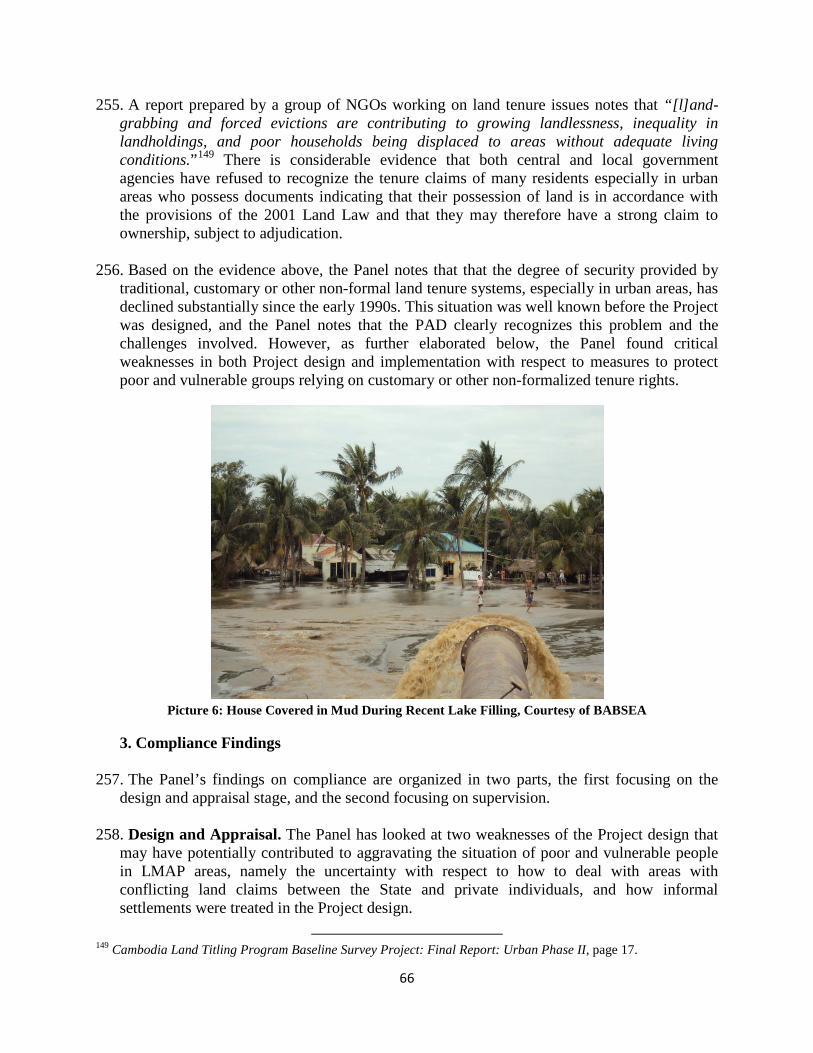
66
255. A report prepared by a group of NGOs working on land tenure issues notes that “[l]and-grabbing and forced evictions are contributing to growing landlessness, inequality in landholdings, and poor households being displaced to areas without adequate living conditions.”149
There is considerable evidence that both central and local government agencies have refused to recognize the tenure claims of many residents especially in urban areas who possess documents indicating that their possession of land is in accordance with the provisions of the 2001 Land Law and that they may therefore have a strong claim to ownership, subject to adjudication.
256. Based on the evidence above, the Panel notes that that the degree of security provided by traditional, customary or other non-formal land tenure systems, especially in urban areas, has declined substantially since the early 1990s. This situation was well known before the Project was designed, and the Panel notes that the PAD clearly recognizes this problem and the challenges involved. However, as further elaborated below, the Panel found critical weaknesses in both Project design and implementation with respect to measures to protect poor and vulnerable groups relying on customary or other non-formalized tenure rights.
Picture 6: House Covered in Mud During Recent Lake Filling, Courtesy of BABSEA
3. Compliance Findings
257. The Panel’s findings on compliance are organized in two parts, the first focusing on the design and appraisal stage, and the second focusing on supervision.
258. Design and Appraisal. The Panel has looked at two weaknesses of the Project design that may have potentially contributed to aggravating the situation of poor and vulnerable people in LMAP areas, namely the uncertainty with respect to how to deal with areas with conflicting land claims between the State and private individuals, and how informal settlements were treated in the Project design.
149 Cambodia Land Titling Program Baseline Survey Project: Final Report: Urban Phase II, page 17.

67
259. How ‘Disputed Land’ was treated in the Project design. Although about 80 percent of land
is estimated to be in the State domain, the PAD recognizes that “apparently the State does not know the amount, location and boundaries of the land that falls under it; obviously, much of it would not be surveyed, mapped or titled either.”150 The PAD notes the difference between State public land and State private land and indicates that the State private land can be sold and “is reported to be frequently sold by ministries and State agencies in an ad hoc manner, with the proceeds not returning to the Treasury for public benefit.”151
The PAD refers to the rising number of landless people due to forced or distressed sales and the high number of land disputes.
260. The PAD also notes that “there are suggestions that State agents such as the military and politically connected people have dispossessed people of their land, which is being facilitated by the lack of formal recognition of rights on those lands”152[emphasis added]. Actually, at the time of Project design and appraisal there was abundant evidence of the threat of evictions or forced relocation of people. The PAD also refers to the high number of conflicts over land in Cambodia for several reasons, and notes that the main reason of such conflicts “is uncertainty about where boundaries of land under the control of various State entities or private individuals lie.”153
261. Although the Project was prepared in this context, the PAD included an unclear and confusing reference to “lands in areas where disputes are likely” and stated that the Project will not title such lands until agreements are reached on the status of the land. Although recognizing the difficulty of classifying land and demarcating the boundaries between public and private domains, the Project design expected this important controversial aspect of the Project to be resolved through public consultations. As discussed in detail in section B of this Chapter, during Project implementation, this PAD statement overtime during Project implementation interpreted to exclude lands under dispute. This issue became more acute when land in question was claimed to be State land and characterized as disputed land and its residents were denied the opportunity to claim their possessory rights due to exclusion of such land from the adjudication process under the Project.
262. In an environment where there is no land classification and no mapping to determine the
boundaries of different type of land, most importantly between the State public land and State private land, this Project design led to the determination of land arbitrarily and de facto as State public land. As a result, residents of such lands were declared as informal settlers/squatters and excluded from titling process under the Project.
263. The Panel finds that design flaws in the Project led to the arbitrary exclusion of lands
from the titling process and that this denied residents, especially the poor and vulnerable, the opportunity to claim and formalize their pre-existing rights through the adjudication process under LMAP.
150 PAD, p. 4. 151 PAD, p.4. 152 PAD, p.5. 153 PAD, p.5.
68
264. How ‘informal settlements’ were treated in the Project design. The Project design excluded
informal settlements/squatters from titling process under the Project unless the Government agrees to provide the land to be registered to informal settlers. The PAD noted that the Project will not issue titles where there is no agreement to allocate the land to informal settlers or through land sharing and/or relocation programs. As discussed in detail in section B of this Chapter, provision of tenure security to squatters was left to the UNCHS/UNDP, DfID, and Cities Alliance program. These efforts were under way in the early years of the Project but were discontinued in 2004, and were not replaced. As a result, as acknowledged by Management “for the last five years there has been no program to regularize tenure in informal settlements in a manner that would allow them to be titled under the Project.”
265. The Panel finds that Management failed to acknowledge that terms like ‘squatter’ and
‘informal settlements’ are subjective until determined in fact through the process of adjudication. It should be noted that in Cambodia and other countries, these often represent the poorest and most vulnerable groups in terms of exposure to eviction and other forms of abuse. These design flaws made it difficult for Bank Management to achieve stated objectives of the Project related to poverty reduction and providing tenure security for the poor, and thus did not comply with OMS 2.20.
266. Supervision. The Panel acknowledges that a central objective of the Project was to protect
vulnerable groups while introducing a transparent, ‘modern’ system of land management and tenure. The key components introduced in the Project to support vulnerable people were the strengthening of public awareness and provision of access to legal aid and dispute resolution mechanisms for the poor. Similarly, the support under the Project to improving State land management (Component 5) was viewed as an important means to adjudicate conflicting claims between the State and private individuals. As acknowledged in the Management Response, these components were not implemented as envisaged.
267. Special support for the poor. The Public Awareness and Community Participation (PACP) sub-component was critical to inform and involve the Cambodian public in the registration and adjudication process. Despite repeated attempts, the Project did not contract any NGOs to support the implementation of the Public Awareness and Community Participation Program, although it was recognized that the recruitment of NGOs was essential for improving the effectiveness of the PACP process. Management acknowledges a design flaw of the Project in expecting the Government to contract civil society organizations, and notes that NGOs did not want to engage in a contract with the Ministry, and that no workable solution was found.
268. The Project did not contract NGOs to provide legal assistance to the disadvantaged under
the dispute resolution mechanism. According to Management, the Ministry was not successful in awarding contracts to scale up the LMAP after a pilot program with local NGOs. Management accepts that “alternatives to the recruitment of NGO using the resources of the Credit should have been considered at the implementation stage”.

69
269. State land management. Similarly, the land management component was only partially implemented. While the Government had developed an improved legal framework for land classification, its implementation progressed much more slowly and much less systematically than anticipated in the Project design. No provinces, districts or communes at the time of Management’s Response had a land classification map showing the boundaries and types of land under public use. Consequently, Management considered this component the least satisfactory component of the Project. Management notes that the Project design “underestimated the complexity and politically fraught nature of State land management.”154
270. The Panel finds that not all measures specifically designed to support poor and vulnerable people were implemented as planned. The Panel finds that Management did not adequately follow up Project commitments to strengthen public awareness and community participation, ensure legal protection to residents exposed to the risk of eviction, and provide adequate access to dispute resolution mechanisms. This was not in compliance with OP/BP 13.05. The Panel finds that lack of support for the poor due to incomplete and inadequate implementation of several components of the Project left them vulnerable to claims on their land. Management in its Response confirms that these activities important to the full implementation of the Project were delayed or were not implemented by the time the Credit was closed.
F. Claim That Other Communities in Project Provinces Have Experienced Forced
Evictions
1. Requesters’ Claim and Management Response
271. The Requesters claim that “Boeung Kak is not an isolated case. Other urban, rural and indigenous communities throughout Cambodia have been unable to access the land titling and/or dispute resolution mechanisms under LMAP, and thus have not been able to secure their land rights under the formal system developed by LMAP. Some of these communities have experienced increased tenure insecurity and forced evictions”.
272. In its Response, Management acknowledged that “tenure insecurity continues to be a
major problem in Cambodia” and that recent increases in land prices have led to increased pressure, “especially on vulnerable communities living on land deemed to be State Public Land.”155 Management stated that it is “now aware of other areas declared for adjudication under the Project where households have been evicted or are threatened with eviction.” Management also noted that “there is a continuing threat of land alienation and eviction for vulnerable communities.”156
273. Management outlines actions to address these concerns, noting that “[t]he Task Team is gathering information to identify other potential cases of communities that may have been evicted from adjudication areas without proper implementation of the RPF.” Management
154 Management Response, page 31. 155 Management Response, p. 50 156 Management Response, p. 26, para. 61

70
states that “[a]s of October 29, 2009, eight potential cases have been identified, involving 10 villages (or parts thereof).” Additionally, Management claims that since April 2009, it has repeatedly called on the Government to put a moratorium on forced evictions “in Phnom Penh and elsewhere.”
2. Panel Analysis 274. Forced Evictions in Cambodia. Forced evictions is one of the main issues related to
human rights violations in Cambodia, affecting thousands of families across the country in urban and rural areas, predominantly people living in poverty. There is extensive documentation in NGO literature regarding this issue.157 Development Projects have resulted in displacement, particularly in urban and peri-urban areas. According to the World Bank’s Poverty Assessment Report in 2006, between 1998 and 2003 the Municipality of Phnom Penh forcibly evicted 11,000 families, mostly urban poor, living in or near the city center.158 According to Amnesty International some 150,000 Cambodians across the country are known to live at risk of being forcibly evicted.159
275. In 1992, Cambodia ratified the International Covenant on Economic, Social, and Cultural Rights (ICESCR)160 which establishes the right to adequate housing.161 The Committee monitoring the implementation of this Covenant has expressed concerns over forced evictions and their prima facie incompatibility with the requirements of this international human rights treaty.162
276. The Panel notes that forced evictions are not new in Cambodia, and, as noted by the World Bank’s Poverty Assessment in Cambodia, have been ongoing in Phnom Penh since well before the preparation of the Project. Since the Project included major urban settlements, including Phnom Penh, among its Project Provinces, this was a significant reputational risk for the World Bank. The Panel notes that the Project design did not adequately address this important problem and reputational risk.
277. Project Implementation and Application of RPF. There were concerns raised during the
implementation of LMAP regarding transparency and accountability in the systematic titling systems and procedures in early 2005. As a result, an independent review was carried out between November 2005 and January 2006, targeting all 11 Project provinces where
157 For examples, see: Rights Razed: Forced Evictions in Cambodia, Amnesty International 2008, Losing Ground, Cambodian Human Rights Action Committee (CHRAC) 2009, Untitled, BABSEA, COHRE, JRS 2009. 158 Cambodia: Halving Poverty by 2015?, Cambodia Poverty Assessment, World Bank, Phnom Penh, February 2006, p.48. 159 Rights Razed: Forced Evictions in Cambodia, Amnesty International, February 11, 2008, p.7. 160 The International Covenant on Economic, Social and Cultural Rights (ICESCR) is a multilateral treaty adopted by the United Nations General Assembly on December 16, 1966, and in force from January 3, 1976. It commits its parties to work toward the granting of economic, social, and cultural rights (ESCR) to individuals, including labor rights and rights to health, education, and an adequate standard of living. The ICESCR is part of the International Bill of Human Rights, along with the Universal Declaration of Human Rights (UDHR) and the International Covenant on Civil and Political Rights (ICCPR). 161 ICESCR Article 11(1) 162 Committee on Economic, Social, and Cultural Rights, General Comment 4: The right to adequate housing (art. 11 (1) of the Covenant), Sixth Session, December 13, 1991, para. 18.

71
systematic land titling by LMAP was underway.163
According to its executive summary, the Review adopted and involved participatory approaches using interviews with beneficiary households, supplemented with findings from informal group discussions held with village groups and key informants, to validate and elicit additional information on the local experiences with the systematic land titling process.
278. Overall, 1,236 household representatives participated in interviews, and informal group discussions were held in 53 villages in 19 declared adjudication areas in the 11 Project Provinces. The Independent Review notes that
No information on the possible rights and entitlements to claim property (particularly State property) through contesting the States’ claim to land was provided, the lack of which appears to be (‘significantly’ and) adversely affecting at least a fifth (19.6%) of all households, findings of this nature were found in 13164
of the 19 district adjudication areas visited. (emphasis in original)
279. According to the Independent Review, no documented reasons for refusal of titles or registration were provided to households and families. Furthermore, the Review highlights that blanket imposition of State land reserves appeared to have a significant impact on the objective and goals of LMAP. As noted above, the Review reports that 20 percent of communities consulted felt that they have “lost” some of their land because of claims by the State. As was in the case of BKL, the Review noted incidents where households were told that they were living on disputed land which was “State land”. Furthermore, the Report notes that no information had been given to households regarding their possible rights to compensation for adverse impacts, as outlined in social safeguards applicable to LMAP.
280. Despite the clear findings of the Independent Review, and repeated findings in
Management supervision reports indicating the inadequacy of dispute resolution mechanisms, especially when powerful parties are involved, Bank Management did not take concrete measures to address these adverse impacts. Supporting the Review’s findings, none of the supervision reports note any incidence of the application of the RPF. The Panel notes that the RPF was not applied during the implementation of the Project considering its broad coverage regarding State land.
281. Management’s Recent Actions. According to various sources, forced evictions reached
crisis proportions in 2009, when at least 26 forced evictions displaced around 27,000 people. In January 2009, a UN independent expert called the forced eviction of Cambodians a “‘grave breach’ of human rights” and called for damages to be paid for lost homes and the provision of alternative housing.165
163 Independent Review of Transparency and Accountability Issues, February 2006 164 The review lists Phnom Penh (Toul Kork), Kandal (Kandal Stung), Kampot (Kampong Trach, Angkor Chrey), Kampong Spueu (Samroang), Prey Veng (Ba Phnom, Prey Veng), Sihanoukville (Mittapheap), Siem Reap (Siem Reap), Takeo (Samroang, Bati), Kampong Thom (Santuk) and Kampong Cham (Batheay). 165 “Forced evictions leave thousands homeless in Cambodia, says UN expert.” UN News Center, January 30, 2009. <http://www.un.org/apps/news/story.asp?NewsID=29723&Cr=housing&Cr1=human+rights>

72
282. On July 16, 2009, following the Enhanced Review Mission which found that the BKL events were linked to LMAP, Management, together with nine other donors, issued a public statement calling for a halt to evictions of Cambodia’s urban poor. More than 60 Cambodian and International NGOs subsequently endorsed this statement.166
283. Bank Management informed the Panel that in December 2009, Management undertook limited field research to understand whether there were any overlaps between reported evictions by NGOs and the media and systematic titling areas under LMAP. The review found that, in addition to the evictions at BKL which are affecting around 4,250 families, about 20 villages were identified that fall within declared adjudication areas, and where evictions have occurred or are threatened, potentially affecting about 2,600 families. The review’s initial findings note that there were no public displays in half of the 23 cases examined, and most of the cases do not appear to have gone through the envisaged systematic titling procedure. According to the review, while several of the evictions seem to involve people living on State land claimed by the Government, the RPF appears not to have been applied and in most cases affected people either did not receive any compensation or received compensation not in accordance with OD 4.30 Bank Policy on Involuntary Resettlement.
284. The Panel notes that although there are several documents indicating that a significant
number of families were adversely affected, the extent of the negative impact on families living in adjudication areas is unknown. The Panel is extremely concerned about the large number of people who were forcibly evicted, displaced, or are under threat of eviction in Project areas.
3. Compliance Findings
285. Inadequate Monitoring and Evaluation. The DCA required that a monitoring and
evaluation system be developed for the Project by December 31, 2002. The review of the supervision reports shows that there was no monitoring and evaluation system for the Project until 2007. During the Project’s midterm review from September 27 to October 11 2004, the Task Team noted the urgent requirement to establish a systematic and robust monitoring and evaluation system for LMAP, to be completed by January 31, 2005. The following two supervision missions, in June and November 2005, noted repeated inaction in the establishment of a monitoring and evaluation system.
286. Eventually, following the suspension period, a monitoring and evaluation manual was
approved by LMAP in December 2006. The supervision mission from May 30-June 8, 2007 reported that the Project had begun to apply the redesigned monitoring and evaluation system, however insufficient time had elapsed since adoption of the system to assess its effectiveness. As acknowledged by Bank Management, the events in central Phnom Penh in the LMAP adjudication area involving more than 4,000 families only came to Management’s attention by chance during a June 2008 supervision mission. A review of the supervision reports shows that there was no monitoring and evaluation system for the Project until 2007. The Panel finds that due to lack of a robust monitoring and evaluation system for
166 Management Response, p. 25.

73
the Project, Bank Management did not become aware of significant issues arising from the Project. This does not comply with OP/BP 13.05.

74
Chapter 4: Lessons and Systemic Issues
287. This investigation has revealed systemic issues of broader relevance to Bank operations. This Chapter discusses three such issues that the Panel considers of particular importance: the management of risks, land titling as a single-instrument approach, and the challenge of land management and administration projects. We hope this discussion may provide lessons that could help strengthen future policy compliance and overall development effectiveness.
288. Management of risks. The initial Project design envisaged a multi-pronged strategy
including components both to address the issue of supporting the poor and vulnerable in the adjudication process and increased transparency and predictability in determining State land. The PAD acknowledged, however, that there were high or substantial risks associated with several of the assumptions deemed critical for achieving the stated objectives. For instance, the PAD states that there is a ‘substantial’ risk that the Government would lack commitment to ensuring that disputes resolution mechanisms function efficiently and fairly, and identifies as a risk mitigation measure that “the project will be scaled back if commitment to a fair process of dispute resolution is inadequate”.
289. As reported in Chapter 3, all the essential elements of the Project strategy that were
intended to mitigate this risk were delayed in implementation, partly implemented or not started. Still, the Project, with active encouragement of Management, took steps to intensify the efforts to achieve targets in terms of titling. This included inter alia the introduction of performance-based payments to staff. In view of the current process in the Bank to introduce a differentiated approach to investment lending based on the assessment of risk, the LMAP experience represents important lessons.
290. Firstly, the preparation of LMAP was supported by an assessment (i.e. the Social
Assessment) of the political economy of land management in Cambodia, and was designed in response to the risks involved. However, in hindsight, it is evident that there was not full ownership among the stakeholders of the multi-pronged approach which was developed. What looked reasonable on paper turned out not to be realistic.
291. The Panel believes that the Bank has an important development role in financing high risk
operations, but the LMAP experience shows the danger of responding to risks by creating an excessively complicated project. The Panel found that new components were added during the preparation process at the expense of clarity in how the different parts were supposed to be functionally interconnected, and without due consideration of the feasibility of the total approach.
292. Secondly, the supervision of LMAP did not adequately take cognizance of the risks
involved. The Panel found, as noted in the previous chapter, that social experts were not included in supervision missions despite the concerns raised in the PAD with regards to safeguarding the interests of poor and vulnerable. Warning signals from independent observers seem not to have been considered. The program for impact monitoring had a very slow start, with the urban baseline study completed in 2007 – five years after the Project

75
started. The Panel could not find any record of Management advocating a slowing down of the titling process awaiting advancement on the other components that were lagging behind.
293. The Panel acknowledges that many factors beyond the control of Management contributed
to this unevenness in progress, but this does not explain or justify the apparent lack of a robust risk management strategy for the Project. With such a strategy in place from the start of this operation, the later difficulties of the Project would have been less likely.
294. Land titling as a single instrument approach. The LMAP, in line with several other
contemporary land management projects, was justified both as a means to stimulate economic growth and as a means to reduce poverty through improved security of tenure for poor and vulnerable people. The lessons from LMAP and other land related investigations, however, show that land titling in itself cannot be expected to realize such diverse social and economic policy objectives in a range of contexts. In the view of the Panel’s expert, it has proved effective in areas where competition for land is at a relatively low level and where disputes are therefore limited, but ineffective and, in some circumstances, counter-productive, in increasing tenure security in areas where the increase in land values is significant and where this may attract predatory interest.
295. The Panel found that such ambiguities in project design and outcomes were raised in
independent studies and also some staff supervision reports only a few years after Project start up. These warning signals apparently were not taken seriously until the BKL issue came as a wake-up call. Rather than reviewing these lessons as they emerged, the Project converged more and more towards a single instrument approach measuring success in terms of numbers of titles issued. The effects of this approach in terms of poverty reduction, the second objective, were never seriously investigated. One operational lesson is that the mid-term reviews might have included a thorough review of Project objectives and design.
296. The LMAP experience, however, should not discourage the Bank from operating in urban
areas, though it does suggest that great care needs to be exercised in designing projects and programs that are sensitive to local contexts. This applies particularly to projects concerned with improving the efficiency and equity of land and housing markets in areas of rapid urbanization.
297. The challenges of land management and administration projects. As the Panel also
noted in its recent Report on the Panama – Land Administration Project, the Panel’s investigation of these two Projects have highlighted the risks associated with land management and administration projects, showing that land projects are complex and difficult to implement effectively and are often politically controversial. Future engagement in these projects would benefit from strengthened technical support, a more systematic assessment of operational risks and risks of a political economy nature, and the allocation of adequate trained staff and resources.

76
ISSUE MANAGEMENT RESPONSE PANEL FINDINGS
Claim that events in BKL are lined
to LMAP.
Management in its Response states that “[T]he Sras Chok adjudication area was an area in which the project was carrying out systematic land titling”, and therefore the procedures for systematic adjudication and the environmental and social guidelines agreed for LMAP would apply.
Panel finds that BKL area is within a Project Province and was declared for adjudication under LMAP, hence activities relating to verification of land tenure and ownership subsequent to notice of adjudication are directly linked to Project. This is consistent with Management’s position.
Claim that the residents of BKL
were denied adjudication of their property claims under
LMAP.
Management concurs with the Requesters, stating that “Management concluded that proper procedures were not followed in the adjudication of the Sras Chok commune”. The residents of the BKL area, according to the Response, were not given an opportunity to present their claims of their possession of land and there is no evidence that a transparent participatory process was carried out to determine the classification of land in the area. Management also notes that “[t]he process that was started under LMAP with the adjudication of the area was not completed according to the agreed procedures.”
Management states that “[a]ccording to information provided by MLMUPC staff in June 2008, in the villages around BKL only the village boundaries were demarcated during the systematic titling process and no demarcation of individual parcel boundaries was undertaken. Ownership in the area is understood to be shown on cadastral records as “unknown”. This appears to be the
It is Panel’s view that parts of BKL area may be eligible for consideration of titling for private ownership under adjudication procedures of LMAP. Panel concurs with Management that residents in BKL area were denied access to a due process of adjudication of their property claims. Panel finds that residents of BKL area were justified in expecting that their claims to land were eligible for consideration under systematic land titling, and furthermore that all land claims in commune were to be adjudicated in accordance with procedures and processes for adjudication of property claims, agreed between Government, Bank and Development Partners supporting LMAP.
Panel notes that Sub-Decree 46 and adjudication procedures developed under LMAP do not include any provisions for excising portions of a declared adjudication area, once process has legally started. Panel also notes that there is no reference in any key Project documents to principles for determining ‘areas where disputes are
ANNEX 1: Table of Findings

77
classification that is generally used when State Public Land is encountered during the titling process as well as when land is subject to a dispute that cannot be resolved during the titling process at the field level”.
Management acknowledges that in retrospect, “supervision of safeguards and other social measures should have been more robust … and acknowledges that supervision reporting on safeguards issues, up to the most recent safeguards mission in mid-2009, could have been improved.”
In its Response, Management also outlines actions that they plan to take to remedy the situation. Management notes that the relations between the Bank and the Government have been strained by the developments around the BKL events and that the Government has repeatedly stated its disagreement with the linkage between the Project and the BKL evictions. The Government cancelled the Project on September 7, 2009 as a result of this disagreement. Although Bank Management indicated to the Government that its obligations under the Development Credit Agreement remain until the full payment of the Credit, the Government continued to disagree on the implementation of the proposed actions by Bank Management.
likely’ or procedures for how to excise such areas from systematic land titling.
Panel notes that decision not to support regularization of informal settlements under Project is not accompanied, in PAD or Development Credit Agreement, with a formal definition of terms ‘informal settler’, ‘informal settlement’, or ‘squatter’. It is Panel’s understanding that primary objective of Project was, in absence of clear land classification boundaries, to determine legality of any claims to land, including by people who prima facie seem to be illegally occupying land, through an adjudication process.
Despite statement in PAD to coordinate closely with UNCHS/UNDP program dealing with informal settlers and squatters, Panel was unable to obtain any evidence during its investigation that any such coordination or support was provided by Project to UNCHS/UNDP program prior to it being ended in 2004. Nor was any evidence obtained of a change in approach towards informal settlements following this date.
Panel concurs with ERM’s findings that lack of State land mapping has contributed to de facto determination of State land (public and private) without applying the LMAP adjudication process.
Panel finds that Project design is not clear what will be Project’s strategy both with respect to determining areas

78
for systematic land titling (i.e. adjudication areas) and dealing with disputes between State entities and private individuals during adjudication process.
Panel finds that these ambiguities in Project design in part contributed to harm that Requesters are facing. Consequently, Panel finds that although risks associated with Project were properly identified, Management did not comply with OMS 2.20 on Project Appraisal with respect to addressing these risks.
Panel finds that Management’s supervision of Project for several years overlooked critical issue of adjudicating private claims on land claimed by State. This failure of Management, in Panel’s view, contributed to events in BKL area and harm that Requesters are facing. Management’s supervision of this critical issue did not meet requirements of OP/BP 13.05.
Panel finds that Management failed to act on information when problems arising in BKL area were first brought to its attention, and that Management’s supervision in this respect was not consistent with requirements of OP/BP 13.05.
Panel finds that Management’s recent supervision of Project, on issues raised by Request, complies with Bank Policy on Project Supervision OP/BP 13.05.

79
However, Panel concurs with Requesters’ assessment that “it is evident that the actions taken by the Bank Management were too late to prevent the harms now being done.”
Claim that residents of BKL were displaced in
violation of agreed policies for
involuntary resettlement.
Management in its Response confirms that the DCA required the application of the RPF in the event of evictions from state land under the Project component providing for systematic and sporadic titling. Management states that the titling component of the Project, due to financial, institutional, technological and human capacity constraints, was designed to be implemented sequentially on selected adjudications areas first, and then moving on to other locations once the former were completed. It adds that the RPF application was supposed to follow the same sequence. Therefore, Management states, it was “clearly
Panel finds that decision to prepare a Resettlement Policy Framework complied with provisions of applicable policy – OD 4.30. Panel commends Management for broadening range of situations where Policy would apply, reflecting new thinking within Bank at the time regarding proper application of Bank’s safeguards. Panel finds that there are several ambiguities with respect to how Resettlement Policy Framework should be triggered and applied. Panel finds that design of the Resettlement Policy Framework fell short of provisions anticipated in OD 4.30 with respect to “planning principles, institutional arrangements,
80
albeit implicitly contemplated” that there would be areas were the Project would not be active and that the RPF would not apply.
With respect to the BKL area specifically, Management concurs with the Requesters that the Resettlement Policy Framework should have been applied to the displacements that occurred in the Sra Chok commune. As specified in the DCA, the RPF was to be applied in the event of evictions from state land as a result of project activities, and a site specific resettlement action plan should have been prepared for review and approval by the Bank. Management agrees with the Requesters that, although it was still not clear whether the BKL area had been titled to the State, the lease that the Government granted to a private developer on the land in 2007 constituted a de facto determination that the land was State land. In the view of Management: “To exclude the application of the RPF to evictions in a Project adjudication area because the adjudication process was apparently not followed to its conclusion and no formal title was issued in the name of the State, would be contrary to the intentions underlying the development of the RPF, as set out in the DCA.”
Management in its Response refers to the position of the Government, which argues that the BKL area was not a concern of the Project because the BKL land was not titled to the state by LMAP. While Management objects to
and design criteria”.
Panel finds that Management’s attention to social consequences of land titling, including potential evictions, was not systematic and suffered from a lack of attention from social safeguard specialists. It is a matter of concern that several supervision missions concluded that there had been no situation requiring application of Social and Environmental Safeguards, including RPF, apparently without any careful scrutiny of matter. Panel finds evidence in supervision records that Management on several occasions raised issues related to State land management potentially relevant for application of the RPF. Panel commends Bank for pursuing this difficult policy issue in Cambodian context, which is both politically sensitive and complex. However, follow-up of these issues was inadequate and contributed to problems in BKL area. This is not in compliance with the provisions of OP/BP 13.05 on Project Supervision.
Panel finds that failure of Management to ensure application of Resettlement Policy Framework was not in compliance with OD 4.30 and with OP/BP 13.05 on Project Supervision.
Overall, Panel is of view that Bank Management should have detected serious problems faced by people in BKL area at an earlier stage, and considered appropriate actions. Failing
81
this argument for the reasons noted in the previous paragraph, it also acknowledges that “a lack of specificity in the Project documents and the apparent absence of detailed discussions of the reach of the RPF, either during design or implementation, may have contributed to Government’s understanding of its obligations.” It also states that, until the BKL events occurred, neither Management nor the Ministry of Land had considered that, even if the titling process was not complete, actions could take place within an adjudication area that could call for the application of the RPF.
Management recognizes that people in BKL were subjected to pressures to relocate and that there was no adequate consultation or negotiation process regarding the relocation. As regards the compensation offered to the people, it states: “it appears that the proposed packages were not equivalent to what people would have received had the RPF being implemented.” It notes, however, that since the procedures set forth in the RPF were not implemented a definite assessment of the fairness and adequacy of the packages offered cannot be made.
The Response also details the more recent efforts by Management to engage in a dialogue with Government on the problem of evictions in urban areas. This included a proposed moratorium on evictions awaiting a national resettlement policy and improvement of the conditions of
to do so was not in compliance with Bank Policy on Project Supervision.
The Panel finds that RPF is generally in compliance with OD 4.30. There is, however, lack of guidance as to rehabilitation and income restoration activities, which according to RPF, should have been detailed in a resettlement plan.
The Panel finds that process of carrying out evictions in BKL area, level of compensation, and standard of resettlement sites do not follow principles laid down by RPF and related provisions of OD 4.30.

82
resettlement sites. Specifically, Management offered its support to improve the living conditions and livelihood of the people from BKL who chose to resettle at the site outside of Phnom Penh.
Claim That the Titling Process Adopted By the
Project Weakens Pre-
existing Tenure Rights
In its response, Management states that it “is uncertain how the term ‘customary rights’ is being used.” According to Management, a key feature of the 2001 Land Law indicates that possession rights are recognized as convertible into formal title if certain conditions are met. Management notes that titling should strengthen the possession rights that are recognizable under the land law. Management states, however, that “pre-existing rights could be compromised by a process with the shortcomings that were evident in the case of the Sras Chok adjudication, including the apparent absence of a transparent, criteria-based and reviewable decision as to whether the land in question was State Public Land.”
The Panel notes that Project undoubtedly has benefitted approximately 1 million households and recognizes this important achievement of LMAP.
Panel finds that design flaws in Project led to arbitrary exclusion of lands from titling process and that this denied residents, especially poor and vulnerable, opportunity to claim and formalize their pre-existing rights through adjudication process under LMAP.
Panel finds that Management failed to acknowledge that terms like ‘squatter’ and ‘informal settlements’ are subjective until determined in fact through process of adjudication.
These design flaws made it difficult for Bank Management to achieve stated objectives of Project related to poverty reduction and providing tenure security for poor, and thus did not comply with OMS 2.20.
Panel finds that not all measures specifically designed to support poor and vulnerable people were implemented as planned. Panel finds
83
that Management did not adequately follow up Project commitments to strengthen public awareness and community participation, ensure legal protection to residents exposed to risk of eviction, and provide adequate access to dispute resolution mechanisms. This was not in compliance with OP/BP 13.05.
Claim that other communities in
Project Provinces are experiencing forced evictions.
In its Response Management acknowledges that “tenure insecurity continues to be a major problem in Cambodia” and that recent increases in land prices have led to increased pressure, “especially on vulnerable communities living on land deemed to be State Public Land.” Management states that it is “now aware of other areas declared for adjudication under the Project where households have been evicted or are threatened with eviction.” Management also noted that “there is a continuing threat of land alienation and eviction for vulnerable communities.”
Management outlines actions to address these concerns, noting that “[t]he Task Team is gathering information to identify other potential cases of communities that may have been evicted from adjudication areas without proper implementation of the RPF.” Management states that “As of October 29, 2009, eight potential cases have been identified, involving 10 villages (or parts thereof).” Additionally, Management claims that since April 2009, it has repeatedly called on the Government to put a
Panel notes that forced evictions are not new in Cambodia, and, as noted by World Bank’s Poverty Assessment in Cambodia, have been ongoing in Phnom Penh since well before preparation of Project. Since Project included major urban settlements including Phnom Penh among its Project Provinces, this was a significant reputational risk for World Bank. Panel notes that Project design did not adequately address this important problem and reputational risk.
Despite clear findings of Independent Review and repeated findings in Management supervision reports indicating inadequacy of dispute resolution mechanisms, especially when powerful parties are involved, Bank Management did not take concrete measures to address these adverse impacts. A review of supervision reports shows that there was no monitoring and evaluation system for Project until 2007. Panel finds that due to lack of a robust monitoring and evaluation system for Project, Bank Management did not become aware of significant issues arising from Project.

84
moratorium on forced evictions “in Phnom Penh and elsewhere.”
This does not comply with OP/BP 13.05.
Panel notes that although there are several documents indicating that a significant number of families were adversely affected, extent of negative impact on families living in adjudication areas is unknown. Panel is extremely concerned about large number of people who were forcibly evicted, displaced, or are under threat of eviction in Project areas.
85
ANNEX 2: Biographies
Panel Members
Mr. Roberto Lenton (Argentina) was appointed to the Panel in September 2007 and became its chair in November 2009. He earned a civil engineering degree from the University of Buenos Aires and a Ph.D. from the Massachusetts Institute of Technology (MIT). A specialist in water resources and sustainable development with more than 30 years of international experience in the field, he serves as chair of the Water Supply and Sanitation Collaborative Council and member of the board of directors of WaterAid America, and served until July 2009 as chair of the technical committee of the Global Water Partnership. Mr. Lenton is a coauthor of Applied Water Resources Systems and coeditor of “Integrated Water Resources Management in Practice,” and a lead author of Health, Dignity and Development: What Will it Take?, the final report of the United Nations Millennium Project Task Force on Water and Sanitation, which he co-chaired. Earlier, Mr. Lenton was director of the Sustainable Energy and Environment Division of the United Nations Development Programme in New York, director general of the International Water Management Institute in Sri Lanka, and program officer in the Rural Poverty and Resources program of the Ford Foundation in New Delhi and New York. He has served as adjunct professor in the School of International and Public Affairs at Columbia University and assistant professor of civil and environmental engineering at MIT. Mr. Alf Jerve (Norway) was appointed to the Panel in November 2008. Mr. Jerve brings to the Panel close to three decades of work in the field of development. A social anthropologist by training, he has been engaged in a wide range of development activities, including extensive field research in Africa and Asia. Among his assignments was a three-year posting to Tanzania with the Norwegian Agency for Development Cooperation as coordinator of a rural development program. From 1993 to 1995, he was responsible for resettlement and rehabilitation issues with projects in Bangladesh during an assignment with the World Bank. In 1995, he became Assistant Director, and served as Director in 2005 and 2006, at the Christian Michelsen Institute in Norway, an internationally recognized development research institution, where he has also devoted his energies and expertise to research and analysis of a wide variety of policy and program issues affecting people in developing countries. Over the years, Mr. Jerve has led and participated in numerous independent evaluations commissioned by bilateral and multilateral development agencies, and served as a member of the Roster of Experts for the Asian Development Bank’s Inspection Function. He earned his magister degree in social anthropology from the University of Bergen, and his bachelor’s degree is in the areas of environmental science and biology. His publications have focused on rural development, decentralization, and poverty reduction and most recently on issues of ownership in development aid cooperation. Ms. Eimi Watanabe (Japan) was appointed to the Inspection Panel on November 1, 2009. Throughout her career, Ms. Watanabe has demonstrated a commitment to applying analytical as well as participatory approaches to development programs, and a strong track record of working collaboratively with civil society organizations, governments, and other development organizations. A sociologist by training, she has been involved in a wide range of substantive areas, at both the project and policy levels, including poverty reduction, governance, gender, 119

86
child health and nutrition, capacity development, environment, and international migration. Ms. Watanabe earned an M.Sc. and Ph.D. from the London School of Economics and received a B.A. in sociology from the International Christian University in Tokyo. From 1998 to 2001, she served as assistant secretary general and director of the United Nations Development Programme (UNDP) Bureau for Development Policy. Prior to that, she was UN resident coordinator and UNDP resident representative in Bangladesh, and UNICEF Representative in India. Recently she has served as a member of the Strategic and Audit Advisory Committee of the United Nations Office for Project Services. Ms. Watanabe brings to the Panel more than 30 years of experience in the field of development.
**************** Expert Consultant
Geoffrey Payne is a housing and urban development consultant with four decades of experience in developing countries. He has undertaken consultancy, research and training assignments in most parts of the world for a wide range of development agencies and directed postgraduate teaching and professional training programmes in leading British academic institutions and a number of developing countries. Geoff founded GPA (www.gpa.org.uk) in 1995 and has published extensively on housing, land policy, property rights, regulatory frameworks and public-private partnerships. He is a trustee of the Building and Social Housing Foundation, an External Associate Adviser to the British Council and a Fellow of the Royal Society of Arts and the Royal Asiatic Society. He is also a founding member of the Development from Disasters Network (DFDN:www.developmentfromdisasters.net) and a member of the RIBA Knowledge Community for Development and Disaster Relief’ (KCDDR) Expert Peer Group. Geoff’s areas of expertise include urban land tenure and property rights, housing policy and project planning, regulatory guidelines for urban development and professional training and capacity building. A central theme of his work involves building local capacity to stimulate social and economic development and reduce urban poverty.
In collaboration with local researchers, Geoff has undertaken research on land tenure issues in many countries, including Cambodia where a review was carried out between 2003-04. This focused on Phnom Penh and involved extensive surveys and case studies and concluded with a workshop and report which identified a number of policy options for incremental change.

Boeung Kok LakeDevelopment Area
(~133 ha.)
Dey KrahomGroup
78
Ruessei Kaev
Tuol Sangkae
Boeung Kok Muoy(Boeung Kok 1)
Boeung Kok Pir(Boeung Kok 2)
Tuek L’ak Muoy
Veal Vong
OuRuesseiBuon
OuRuessei
Pir
PhsarThmei
Pir
Phsar ThmeiMuoy
Phsar ChasPhsar
KandalMuoy
Boeng Reang
OuRuesseiMuoy
PhsarThmei
Bei
PhsarKandal
Pir
Chey Chumneah
Chakto Mukh
Tuol SvayPrey Pir
Tumnob Tuek
Tuol Svay Prey Muoy
Boeng Keng Kang Be
Tuol TumpungPir
Tuol TumpungMuoy
BoengTrabaek
Phsar Daeum Thkov
Oulampik Boeng KengKang Pir
Boeng KengKang Muoy
Tonle Basak
Tuek L’ak Pir
Tuek L’ak Bei
Phsar Depou Bei
Phsar Daeum Kor
Boeng Salang
Phsar Depou PirOu
Ruessei Bei
Boeng Prolit
Phsar Depou Muoy
Sras Chok
Mittakpheap Monourom
Voat Phnum
ChrouyChangva
Phnom Penh Thmei
Tuek Thla
StuengMean Chey
Nirouth
Chak Angrae LeuChbar Ampov
Muoy
ChbarAmpov Pir
BoengTumpun
Ruessei KaevRuessei Kaev
Tuol Kouk
7 Makkara
ChamkarMon
Mean Chey
Mean Chey
DounPenh TONLE SAP
MEKONG
TONL
E BAS
SAC
MEKONG
Boeung KokLake
(~90 ha.)
0 1 2 3 Kilometers
KA
ND
AL P
RO
VIN
CE
PH
NO
M P
ENH
PR
OV
INCE
Gulf
of
Thailand
SOUTH
CHINA
SEA
PhnomPenh
MYANMAR
CAMBODIA
LAOP.D.R.
CHINA
THAILAND
VIETNAM
Ruessei Kaev
Tuol Kouk
7 MakkaraChamkar
MonMean CheyDang Ko
DounPenh
TONLE SAP MEKONG
MEKONG
TONLE BASSAC
0 1 2 3 Kilometers
KANDALPROVINCE
PHNOM PENHPROVINCE
KANDALPROVINCE Area of Main Map
For detail, see IBRD 38243
CAMBODIALAND MANAGEMENT ANDADMINISTRATION PROJECT
Referenced VillagesREFERENCED VILLAGES: ADJUDICATED NON-ADJUDICATED
BOEUNG KOK LAKEDEVELOPMENT AREA BOUNDARY
SAND FILL AS SHOWN INMANAGEMENT RESPONSEDATED NOVEMBER 2, 2009
DISTRICT HEADQUARTERS
COMMUNE BOUNDARIES
DISTRICT BOUNDARIES
PROVINCE BOUNDARY
ROADS
IBRD 38242
NOVEMBER 2010
The boundaries, colors, denominations and any other informationshown on this map do not imply, on the part of The World BankGroup, any judgment on the legal status of any territory, or anyendorsement or acceptance of such boundaries.

June2009
March2009
Nov.2008 Sep.
2008
Boeung Kok LakeDevelopment Area
(~133 ha.)
Tuol Sangkae
Boeung KokMuoy
(Boeung Kok 1)
Boeu
ng K
ok P
ir (B
oeun
g Kok
2)
Veal Vong
Ou RuesseiBuon
OuRuessei
Pir
PhsarThmei
Pir
Phsar ThmeiMuoy
Phsar Chas
PhsarKandalMuoy
Boeng ReangOu Ruessei
Muoy
PhsarThmei
Bei
PhsarKandal
Pir
Chey ChumneahPhsar Depou Bei
Phsar Depou Pir OuRuessei Bei
Phsar Depou Muoy
Sras Chok
Mittakpheap Monourom
Voat Phnum
ChrouyChangva
Ruessei Kaev
TuolKouk
7 Makkara
DounPenh
TONLE SAP
Boeung KokLake
(~90 ha.)
0.1 .2 .5
KILOMETERS
1
Gulf
of
Thailand
SOUTH
CHINA
SEA
PhnomPenh
MYANMAR
CAMBODIA
LAOP.D.R.
CHINA
THAILAND
VIETNAM
Ruessei Kaev
Tuol Kouk
7 MakkaraChamkar
Mon
Mean Chey
Dang Ko
DounPenh
TONLE SAP MEKONG
MEKONG
TONLE BASSAC
0 1 2 3 Kilometers
KANDALPROVINCE
PHNOM PENHPROVINCE
KANDALPROVINCE
Area of Main Map
CAMBODIALAND MANAGEMENT ANDADMINISTRATION PROJECT
Sras Chok CommuneREFERENCED VILLAGES
SRAS CHOK COMMUNE
BOEUNG KOK LAKEDEVELOPMENT AREA BOUNDARY
SAND FILL AS SHOWN INMANAGEMENT RESPONSEDATED NOVEMBER 2, 2009
DISTRICT HEADQUARTERS
COMMUNE BOUNDARIES
DISTRICT BOUNDARIES
PROVINCE BOUNDARY (inset)
ROADS
IBRD 38243
NOVEMBER 2010
The boundaries, colors, denominations and any other informationshown on this map do not imply, on the part of The World BankGroup, any judgment on the legal status of any territory, or anyendorsement or acceptance of such boundaries.