investigation of failure mechanism of lungchok landslide
TRANSCRIPT

Article 1
Investigation of failure mechanism of Lungchok 2
landslide, Sikkim (India) 3
Neharika Rao Ganta 1*, Neelima Satyam2 4
1 Research Scholar; [email protected] 5 2 Associate Professor; [email protected] 6 * Correspondence: [email protected]; 7
8
Abstract: Globally 30% of landslides occur in the northeastern part of India [1]. One of the major 9 earthquake events in Sikkim, India occurred on 18th September 2011 (Mw 6.9) led to over 300 10 landslides and 122 human deaths [2]. These landslides not only controlled by natural disasters but 11 initiated due to human activities. The present study considered Lungchok landslide occurred in 12 south district of Sikkim due to 2011 seismic event. The study focused on the failure mechanism of 13 the landslide based on finite element analysis by adopting eight different cases. The deformation 14 characteristic was investigated for dry and saturated slope conditions under static and dynamic 15 behavior considering vehicle loads using GeoStudio software. The FEM analysis has been carried 16 out using load deformation and linear elastic. The analysis shows that the failure of the slope was 17 not sudden due to the 2011 earthquake event, but progressive failure was observed with time and 18 construction activity. The paper demonstrates that, an increase in infrastructure development 19 including construction by hill cutting increased the initiation of landslide with soil erosion. The 20 cracks developed after 2011 earthquake event led to further deformations during future disasters 21 required effective stabilization measures. 22
Keywords: Finite Element method; Earthquake induced landslide; Static and dynamic analysis; 23 Deformation based failure; 24
25
1. Introduction 26
Landslides are the significant geological hazards observed in mountain regions which lead 27 immense damage to roads, buildings and infrastructure [3, 4]. The mountain area of northeast India 28 covers around 60% of the total area. The landslide’s in India prone to 12.6% among which the 5.14% 29 lies in the north-eastern region. It has been noted that the frequency of landslides is increasing in the 30 Himalayan terrain [5]. The landslides vary from north to south and east to west because of climatic 31 condition, seismicity and heavy rainfall. 32
The two primary mechanisms for landslide occurrences are earthquake and rainfall [6]. Apart 33 from natural disasters, geology and climatic conditions also affect landslide occurrences which have 34 been further intensified due to the increased human activities [7]. Studies show that future incidents 35 of landslides would be triggered more due to human disturbances (land use) rather than climatic 36 changes [8, 9]. Froude and Petley [10], in their study on the global dataset of landslide occurrence 37 showed that 40.2% of landslides caused by construction activity and 11.3 % of landslides are due to 38 illegal hill cutting respectively in between 2004 to 2016. These improper construction activities led to 39 soil creeping downwards and activating fine cracks. The further activation of mass movement is 40 quite common in the Himalayan terrain immediately after the rainy season [11, 12]. These failures 41 are intensified more particularly during the earthquake or after the monsoon season [12, 13]. The 42 landslides after an earthquake event are breeding for future geo hazards and thus further intensified 43 during or after the monsoon season [14]. The soil erosion was observed during earthquake lead to 44 the channel for other hazards, and this cyclic process continues. 45
Preprints (www.preprints.org) | NOT PEER-REVIEWED | Posted: 22 August 2019 doi:10.20944/preprints201908.0230.v1
© 2019 by the author(s). Distributed under a Creative Commons CC BY license.

2 of 14
The unstable slopes observed during pre-disaster studies need a clear understanding of the 46 problem through visible signs on land [12]. The pre-disaster studies focus on identifying the 47 vulnerable landslide location which helps in post event studies. The post studies signify more on 48 determining the elements that triggered landslides and analyses the stability of slope concerning 49 factor of safety. Many studies have been developed to understand both rainfall and earthquakes 50 induced landslides using finite element method. However, a detailed slope stability analysis is 51 lacking. Several ways are there to compute the slope safety using limit equilibrium methods, 52 kinematic methods including finite and discrete element modelling. The Finite element method 53 (FEM) commonly used for the stability of slopes can be considered with the complex boundary and 54 loading conditions [15]. The stability analysis using the strength reduction technique in FEM was 55 reported by Cai and Ugai [16]. The assessment of pore pressures with infinite slopes was studied by 56 Collins and Znidarcic [17]. 57
In the present study, the failure channel of Lungchok landslide is investigated using pre and 58 post disaster studied using Google images. The downward movement of the slope with the 59 development of cracks was observed. The failure was initiated by several elements with the 60 involvement of external and internal factors. To investigate the disaster chain of Lungchok landslide 61 the work was categorised into pre and post disasters combined with earthquake and rainfall effect 62 along with vehicle loads. The lungchok slope was examined considering eight different cases 63 including dry and saturated condition under static and dynamic loading along with vehicle loads. 64 The present study deals with deformations under numerical simulation by load deformation and 65 linear elastic analysis using the finite element method to identify the possible failure channel of the 66 Lungchok landslide. 67
2. Details of study area 68
The September 18th, 2011 earthquake led to reactivation of old landslides and activation of 69 fresh landslides [18]. The present study deals with the newly activated landslide due to the 2011 70 Sikkim earthquake. The landslide located near Lungchok town at latitude and longitude of 71 27008'01.88'' N, 88023'41.46'' E respectively shown in Figure 1. It is situated along the roadway 72 between Lungchok and Singtam villages in the south district of Sikkim state at an elevation of 1686 73 m above MSL. 74
Preprints (www.preprints.org) | NOT PEER-REVIEWED | Posted: 22 August 2019 doi:10.20944/preprints201908.0230.v1

3 of 14
75
Figure 1. Location of slope considered for the analysis. 76
The study area is around 73 km from epicentre distance of 2011 event; 16.93 km and 4.02 km 77 away from Main Boundary Thrust (MBT) and Main Central Thrust (MCT) faults respectively. The 78 tectonic collusion and correlation of MBT and MCT is the reason of seismicity in the eastern 79 Himalayan region [19]. The state comprises of slight to moderate earthquakes (Mw 3-6) in the past 80 due to the distribution of MCT, MBT, lineaments and faults. The region comes under seismic zone IV 81 as per Indian standard [20]. The 2011 Sikkim event the moderately high event with a moment 82 magnitude of 6.9 led to 210 landslides including debris, rock slide, and rock fall. The geomorphology 83 and lithology also played an essential role in imitating these landslides during earthquake observed 84 during field study [18]. The frequent landslides are noted in the east and south districts due to the 85 geological covering of Daling group [21]. The south Sikkim is in the physiographic zone of sub 86 Himalayas associated predominantly with phyllite and thinly blended quartzite with surface 87 geology of biotite, tourmaline granite, bouxa dolomite, daling metapelites and Gondwana [22]. 88
The pre-Cambrianmetapelites of Daling group with weathered and fracture rocks accumulate 89 in the southern part of the state [23]. Compared to other districts of Sikkim, the south Sikkim is 90 formed of thin soft slaty half-schistose, and phyllites rocks are highly fragmented [24]. The study 91 area comprises of Gondwana rocks [25]. The moderately steep sloping hill with drained coarse 92 loamy to fine loamy soils of 100cms with greywacke bedrock was observed in the study area [26]. 93 The study area comprises of Gondwana super group with Rangit pebble slate group having 94
Preprints (www.preprints.org) | NOT PEER-REVIEWED | Posted: 22 August 2019 doi:10.20944/preprints201908.0230.v1

4 of 14
conglomenate, pebble/boulder slate and phyllites according to geological survey of India as shown 95 in the Figure 2. 96
97
Figure 2. Geology map of Sikkim (Geological survey of India, 2011). 98 http://www.sikenvis.nic.in/Database/GSI_4420.aspx. 99
From the field observations, the area is covered extensively with thick silty sand with fractured 100 phyllites. The erosion of the soil resulting in landslides is observed in Precambrian rock of phyllites 101 and schist due to its sensitivity and much younger age [18]. The south Sikkim is covered with 2.27 % 102 with the heavily eroded area and 14.33% moderately eroded area. This erosion of soil led to cracks 103 and created channels for infiltration during rainfall. Rainfall increases the pore pressures and 104 responsible for slope failures [27] through infiltration [28]. 105
Increase in rainfall intensity also increases the slope instability by the force of water due to the 106 law of gravity. The rainfall induced landslides are high in the state due to its heavy seasonal 107 precipitation. The central part of the south district receives with more than 2400 mm and adjacent 108 areas with 1200-2400 mm rainfall. The study area receives the mean annual rainfall intensity of 109 2400-2800 mm [29]. The rainfall has been decreased from nine to five months with an increase in 110 intensity after 2007 [29]. Because of the increase in rainfall intensity slope instability is increasing 111 especially along the road networks mainly due to improper fills and unbalanced excavation during 112 road construction. The vehicle loads further led this soil steeping downwards and developed cracks 113 beneath the road section. Rapid infrastructure development is going due to significant role of 114 transportation plays in the life of people in Sikkim. 115
Preprints (www.preprints.org) | NOT PEER-REVIEWED | Posted: 22 August 2019 doi:10.20944/preprints201908.0230.v1

5 of 14
3. Data obtained 116
The Lungchok landslide was identified as a newly initiated landslide occurred during 117 September 2011 earthquake event. The analysis from the aerial photographs during the year 118 2006-2011 respectively showed that the slide was activated after the 2011 earthquake. From the 119 observation of pre and post Google earth images, the failure was initiated from the past. The 120 Lungchok landslide is of rotational slide led to the blockage of the road as it was built on an unstable 121 slope. 122
From Google images, it is observed that the roadway was not constructed until the year 2006 123 shown in Figure 3a. A few years later in 2009, an earthen road 1 and 2 one above the other with an 124 elevation of 0.127 km difference was made on the slope as shown in the Figure 3b. The minor cracks 125 underneath the road one was observed. After a year, the flexible pavement was constructed, and 126 slightly enlarged cracks were found with creeping of soil down towards road two due to the distress 127 of vehicle loads as shown in Figure 3c. The loosen soil abruptly failed when trigged with an 128 earthquake event on September 18th, 2011. The failure slope in between two road section due to the 129 2011 Sikkim earthquake event is shown in Figure 3d. The rotational failure with deformation 130 extended up to 41.3 m towards the road section 2 and completely damaged. The collapse initiated 131 new cracks of 404 m length with 1.30 m width approximately underneath the road 2. 132
133
(a) (b) 134
Preprints (www.preprints.org) | NOT PEER-REVIEWED | Posted: 22 August 2019 doi:10.20944/preprints201908.0230.v1

6 of 14
135
(c) (d) 136
Figure 3. Aerial photographs of the study area: (a) The roadway was not constructed until the year 137 2006; (b) A few years later in 2009, an earthen road 1 and 2 one above the other was constructed and 138 the minor cracks underneath the road one was observed; (c) After a year in 2010, the flexible 139 pavement was constructed, and slightly enlarged cracks were found with creeping of soil down 140 towards road section two; (d) The failure slope in between two road section during 2011 Sikkim 141 earthquake event. 142
The basic slope geometry obtained from the Google map is converted and combined with pre 143 and post digital elevation models (DEM). The pre earthquake DEM (August 2011) data obtained 144 through Cartosat-2 from National Remote Sensing Centre (NRSC, Hyderabad). The post-earthquake 145 DEM (2011, October) data collected from the ASTER GLOBAL satellite provided by U.S. Geological 146 Survey (USGS). The contours maps of pre and post satellite data are generated using ArcGIS 147 software. The slope with pre and post earthquake contours shown in Figure 4. 148
Preprints (www.preprints.org) | NOT PEER-REVIEWED | Posted: 22 August 2019 doi:10.20944/preprints201908.0230.v1

7 of 14
149
Figure 4. Contour maps of the Lungchok slope (Before and after 2011 Sikkim earthqauke). 150
The ground motion obtained from Gangtok station in three directions but the highest 151 acceleration of 0.156g for the time of 193 sec is considered for the analysis as shown in Figure 5. 152
Preprints (www.preprints.org) | NOT PEER-REVIEWED | Posted: 22 August 2019 doi:10.20944/preprints201908.0230.v1

8 of 14
153
Figure 5. Input Ground motion considered for the analysis (18th September 2011 Sikkim earthquake). 154
4. Analysis 155
4.1. Material properties 156
From the field investigation, the soil is silty sand deposits with the combination of disintegrated 157 soft phyllites. Due to regional meta morphic event the rocks of phyllites and quartzite are partially 158 metamorphized. Thus, when completely weathered shows complex characteristics of meta argillite 159 and meta arenite consist of sandy and fine materials. Therefore, the interbedding of sandy silt, silty 160 sand, silty clay and gravel are characterized and formed as weathered soil. The formation of 161 weathering profile and formation was described by Komoo [30]. 162
The soil samples were collected, and laboratory tests were carried out as shown in Table 1. The 163 slope is considered with two layers for the numerical analysis. Top layer is completely weathered 164 silty phyllites at about 20 m deep and bottom layer consist with partially weathered phyllite rock 165 about 132 m. 166
Table 1. Geotechnical properties considered for the analysis. 167
Soil type
Parameters properties
Dry Saturated
Layer 1: Completely
weathered phyllite
with silty sand
Unit weight γ (kN/m3)
Youngs modulus E (MPa)
Poisson’s ratio ν
Elastic Shear Modulus Gmax (MPa)
17.65
780
0.36
15.2
20.9
480
0.42
9.8
Layer 2: Partially
weathered phyllite
rock
Unit weight γ (kN/m3)
Youngs modulus E (MPa)
Poisson’s ratio ν
Elastic Shear Modulus Gmax (MPa)
23.1
1530
0.30
128.8
25.8
1125
0.36
92.50
4.2. Material properties 168
The static and dynamic analysis was performed on Lungchok landslide using GeoStudio 169 software. The slope is examined for eight different cases including dry and fully saturated 170
Acc
eler
atio
n (g
)
Time (sec)
-0.05
-0.1
-0.15
-0.2
0
0.05
0.1
0.15
0.2
0 50 100 150 200
Preprints (www.preprints.org) | NOT PEER-REVIEWED | Posted: 22 August 2019 doi:10.20944/preprints201908.0230.v1

9 of 14
conditions under static and dynamic loads before and after the construction of the road. Table 2 171 shows eight different cases considered for the detailed analysis. 172
Table 2. Cases considered for the analysis. 173
Case 1 Dry + static + without vehicle loads
Case 2 Dry + static + with vehicle loads
Case 3 Dry + Dynamic + without vehicle loads
Case 4 Dry + Dynamic + with vehicle loads
Case 5 Saturated + static + without vehicle loads
Case 6 Saturated + static + with vehicle loads
Case 7 Saturated + Dynamic + without vehicle loads
Case 8 Saturated + Dynamic + with vehicle loads
174 The dry slope analysis represents the arid season condition, and fully saturated slope represents 175
the rainfall during monsoon period considering the water table at the surface. The load deformation 176 for static analysis and linear elastic for dynamic analysis were performed using Sigma/w and 177 Quake/w modules of GeoStudio software. In addition to the eight cases considered, the behavior of 178 the dry and saturated slopes due to vehicle loads at time intervals of 1, 6, 12 and 24 months 179 respectively has been evaluated using load deformation analysis. This study was performed to 180 investigate the proper failure channel of the slope under various conditions. 181
5. Model description 182
The finite element analysis has been carried out to estimate the deformation of the slope. Finite 183 element approach is widely used due to its connectivity in joint elements [31]. The numerical slope 184 model considered for the analysis is of 280 m distance with elevations at the front and rear edge 185 being 1737 m and 1585 m shown in the Figure 6. 186
187
Figure 6. FEM model of slope and clear view of mesh with three node triangular element and vehicle 188 loads at road 1 and 2 sections. 189
Preprints (www.preprints.org) | NOT PEER-REVIEWED | Posted: 22 August 2019 doi:10.20944/preprints201908.0230.v1
10 of 14
The homogeneous slope considered for the analysis was about 152 m elevation. The triangular 190 plane strain elements having three nodes are used for discretization of elements with a total of 6403 191 elements thereby considering 6758 nodes for the entire model and discretized with three nodes of 192 triangular elements. The boundary condition along the base of the slope was fixed at X and Y 193 direction, and the elevation of the slope was kept free in the Y direction. The boundary conditions 194 along the slope face were set free in both X and Y directions for determining the displacements. For 195 the dynamic analysis, the input horizontal ground motion along the base of the slope was applied. 196 The vehicle load has been applied uniformly of 392.26kN/m2 as per Indian Road Congress (IRC): 6, 197 2014 at road 1 and 2. 198
For the chosen problem the 2D slope was simulated using different modules of GeoStudio 199 software. The deformation under static and dynamic loads of the slope was analyzed using Sigma/W 200 and Quake/W modules. The material model used for the dry slope is carried out using the total 201 stress parameters and for the saturated slope effective drained parameters. The water table has been 202 considered at the top surface to represent a fully saturated condition. The analysis is performed by 203 stage wise by loading and unloading of vehicle loads. The vehicle loads are applied as uniformly 204 distributed loads along the road 1 and 2. The static deformations of the slope were executed under 205 body load without any vehicle loads using In-situ deformation analysis and with vehicle load using 206 load deformation analysis. Similarly, the dynamic deformations of the slope without and with 207 vehicle loads were also considered for detailed analysis using linear elastic. 208
6. Results and discussion 209
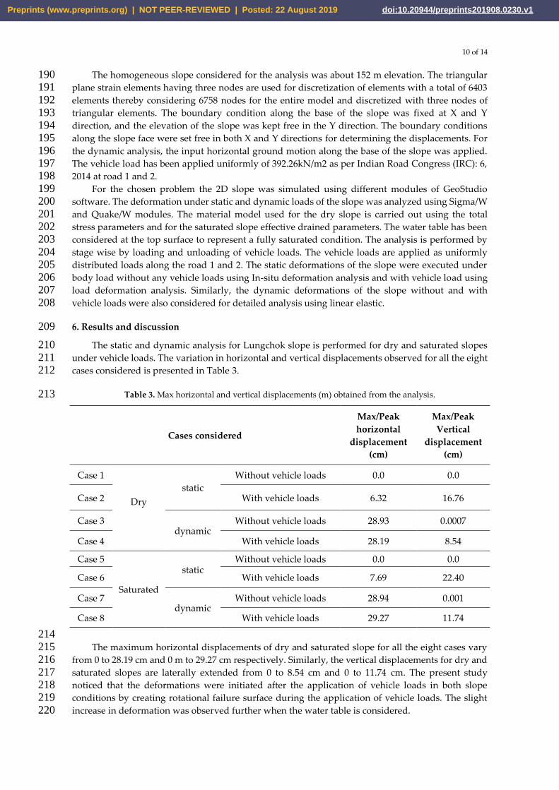
The static and dynamic analysis for Lungchok slope is performed for dry and saturated slopes 210 under vehicle loads. The variation in horizontal and vertical displacements observed for all the eight 211 cases considered is presented in Table 3. 212
Table 3. Max horizontal and vertical displacements (m) obtained from the analysis. 213
Cases considered
Max/Peak
horizontal
displacement
(cm)
Max/Peak
Vertical
displacement
(cm)
Case 1
Dry
static
Without vehicle loads 0.0 0.0
Case 2 With vehicle loads 6.32 16.76
Case 3 dynamic
Without vehicle loads 28.93 0.0007
Case 4 With vehicle loads 28.19 8.54
Case 5
Saturated
static Without vehicle loads 0.0 0.0
Case 6 With vehicle loads 7.69 22.40
Case 7 dynamic
Without vehicle loads 28.94 0.001
Case 8 With vehicle loads 29.27 11.74
214 The maximum horizontal displacements of dry and saturated slope for all the eight cases vary 215
from 0 to 28.19 cm and 0 m to 29.27 cm respectively. Similarly, the vertical displacements for dry and 216 saturated slopes are laterally extended from 0 to 8.54 cm and 0 to 11.74 cm. The present study 217 noticed that the deformations were initiated after the application of vehicle loads in both slope 218 conditions by creating rotational failure surface during the application of vehicle loads. The slight 219 increase in deformation was observed further when the water table is considered. 220
Preprints (www.preprints.org) | NOT PEER-REVIEWED | Posted: 22 August 2019 doi:10.20944/preprints201908.0230.v1

11 of 14
Without the influence of vehicle loads dry and saturated slopes were safe with zero 221 movements. The Horizontal and vertical displacements of both the slopes were increased with the 222 application of vehicle loads were vary from 0 to 6.32 cm and 0 to 22.40 cm as shown in the Figure. 7(a 223 &b). The vehicle loads influenced the vertical deformations compared to horizontal. It clearly shows 224 that the major deformations were increased due to the influence of vehicle loads from zero to 22.40 225 cm within two years of road construction. Further stability of slope was lowered during heavy 226 monsoon season. The rotational displacements were observed clearly in saturated slope by creating 227 the failure surface underneath road one to two. Thus, create a weak shear zone, and this further 228 degrades due to the percolation of the water into the cracks created by the vehicle loads. 229 Consequently, the stability of soil decreased and failed during the earthquake event. 230
231
(a) (b) 232
Figure 7. (a) Horizontal displacements; (b) Vertical displacement of dry and Saturated slope under 233 static loads withvehicle loads. 234
The rotational failure pattern was not observed both in the dry and saturated slopes when no 235 vehicle loads applied in Figure 8a. The vertical deformations observed are also mostly zero as shown 236 in the Figure 8b. The displacements were gradually increased throughout the slope without any 237 deflation, this failure mostly significant creeping of the soil downwards without creating any failure 238
surface. 239
240
(a) (b) 241
Preprints (www.preprints.org) | NOT PEER-REVIEWED | Posted: 22 August 2019 doi:10.20944/preprints201908.0230.v1
12 of 14
Figure 8. (a) Horizontal displacements; (b) Vertical displacement of dry and Saturated slope under 242 dynamic loads without vehicle loads. 243
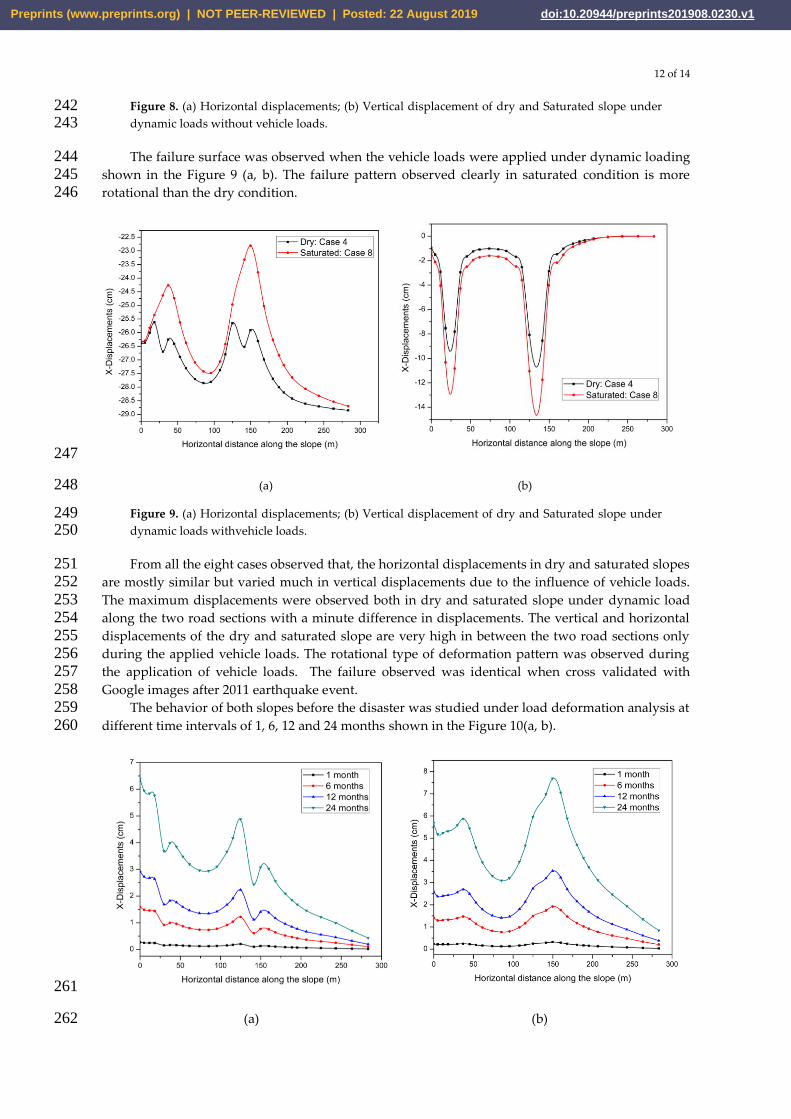
The failure surface was observed when the vehicle loads were applied under dynamic loading 244 shown in the Figure 9 (a, b). The failure pattern observed clearly in saturated condition is more 245 rotational than the dry condition. 246
247
(a) (b) 248
Figure 9. (a) Horizontal displacements; (b) Vertical displacement of dry and Saturated slope under 249 dynamic loads withvehicle loads. 250
From all the eight cases observed that, the horizontal displacements in dry and saturated slopes 251 are mostly similar but varied much in vertical displacements due to the influence of vehicle loads. 252 The maximum displacements were observed both in dry and saturated slope under dynamic load 253 along the two road sections with a minute difference in displacements. The vertical and horizontal 254 displacements of the dry and saturated slope are very high in between the two road sections only 255 during the applied vehicle loads. The rotational type of deformation pattern was observed during 256 the application of vehicle loads. The failure observed was identical when cross validated with 257 Google images after 2011 earthquake event. 258
The behavior of both slopes before the disaster was studied under load deformation analysis at 259 different time intervals of 1, 6, 12 and 24 months shown in the Figure 10(a, b). 260
261
(a) (b) 262
Preprints (www.preprints.org) | NOT PEER-REVIEWED | Posted: 22 August 2019 doi:10.20944/preprints201908.0230.v1

13 of 14
Figure 10. Horizontal displacements of (a) dry; (b) Saturated slope under dynamic loads with 263 vehicle loads. 264
The deformations were increased with time in both dry and saturated slope conditions. The 265 deformation of the saturated slope is high when compared to the dry slope. The maximum 266 deformations observed in both slopes are 6.3 cm and 7.69 cm in 24 months. The deformations are 267 gradually increased beneath the road 1 and extended up to road section 2. The deformation obtained 268 due to vehicle loads created cracks beneath the road 1, and this was observed based on the failure in 269 the ground just after the 2011 Sikkim earthquake event as shown in Figure 3c. These cracks further 270 increased during an earthquake event shown in the Figure 3d. 271
From the results, observed that the failure is not short term, but the preparation process linked 272 with different activities. The deformations were initiated when the additional vehicle load was 273 applied. The results also show that the slope displacements gradually increased with respect time of 274 applied vehicle loads. The failure observed was irrespective to climatic condition but failed was 275 observed more due to vehicle loads. In both slopes models, the displacements are high at the zone of 276 two road sections, and zero deformation at the toe of the slope was observed in each case, and these 277 results are matched with real field scenario. 278
6. Conclusion 279
The landslides caused due to human activities are on an increasing trend and are further 280 aggravated due to earthquake and rainfall. The frequent landslides observed in Sikkim (India) are a 281 combination of earthquake, rainfall and anthropogenic activities. The increase in human activity 282 induced landslides can be attributed to the increase in infrastructure development. The present 283 study is based on a finite element model using Lungchok slope located in south Sikkim, India which 284 failed during the September 2011 earthquake event. The pre-disaster slope was modeled under 285 practicable mechanisms to identify the possible failure channel. The conclusions based on the 286 present study as follows: 287
Two separate conditions of dry and saturated slopes under static and dynamic loadings 288 including vehicle loads based on finite element-based deformation analysis has been performed to 289 understand the proper failure channel. The behavior of slope under vehicle loads from the past two 290 years was studied using load deformation analysis. 291
The linked progressive failure was observed from the results, and the failure was not sudden 292 due to earthquake event alone. This failure was initiated from the past due to vehicle loads and 293 increased slowly with time creating failure surface. The deformations changed the landscape in the 294 long term creating cracks, erosion and soil creeping was abruptly failed during earthquake effect. 295 Thus, the failure initiated new cracks of 404 m length respectively underneath the road 2. 296
The various construction activities especially in hilly areas without an adequate measure 297 usually lead to soil erosion and degrading the soil quality along the lines of weakness and thus cause 298 long term failure with additional effects. 299
From the present study, the Lungchok slope was unstable majorly due to vehicle loads needs 300 continuous monitoring which eventually saves human life. 301
References 302
1. 18th September 2011 Sikkim earthquake-Post-Earthquake Reconnaissance Report - West Bengal. 303 https://ndma.gov.in/images/pdf/NDMA_PERT_WB_DraftReport_21December2011_FINAL.pdf. 304
2. Martha, T.; Govindharaj, K.B.; Vinod, K. Damage and geological assessment of the 18th September 305 2011 Mw 6.9 earthquake in Sikkim, India using very high-resolution satellite data. Geoscience Frontiers 306 2015, 6(6), 793-80. 307
3. Jibson, R.W.; Harp, E.L.; Schulz, W.; Keefer, D.K. Large rock avalanches triggered by the M 7.9 Denali 308 Fault. Alaska Engineering Geology 2006, 83,144-160. 309
4. Petley, D.N. Global patterns of loss of life from landslides. Geology 2012, 40, 927–930. 310
Preprints (www.preprints.org) | NOT PEER-REVIEWED | Posted: 22 August 2019 doi:10.20944/preprints201908.0230.v1

14 of 14
5. Gupta,V.; Sah, M.P. Spatial variability of mass movements in the Satluj valley, Himachal Pradesh during 311 1990-2006. J Mt Sci 2008, 5, 38-51. 312
6. Keefer, D.K. Landslides caused by earthquakes. Geological Society of America Bulletin 1984, 95, 406–421. 313 7. Mehrotra, G.S.; Sarkar, S.; Kanungo, D.P.; Mahadevaiah, K. Terrain analysis and spatial assessment of 314
landslide hazards in parts of Sikkim Himalaya. Journal of the Geological Society of India 1996, 47, 491-498. 315 8. Crozier, M.J. Deciphering the effect of climate change on landslide activity: A review, Geomorphology 316
2010, 124, 260–267. 317 9. Anderson, M.G.; Holcombe, E. Community-Based Landslide Risk Reduction: Managing Disasters in Small 318
Steps. World Bank Publications 2013. 319 10. Froude, M.J.; Petley, D.N. Global fatal landslide occurrence from 2004 to 2016. Natural Hazards and Earth 320
System Sciences 2018, 18, 2161-2181. 321 11. Paul, S.K.; Bartarya, S.K.; Rautela, P.; Mahajan, A.K. Catastrophic mass movement of 1998 monsoons at 322
Malpa in Kaliganga valley, Kumaon Himalaya (India). Geomorphology 2000, 35, 169-180. 323 12. Gupta, V.; Mahajan, A.K.; Thakur, V.C.; A study on landslides triggered during Sikkim earthquake of 324
September 18, 2011. Himalayan Geol 2015, 36, 81-90. 325 13. Tang, C.; Zhu, J.; Qi, X.; Ding, J. Landslides induced by the Wenchuan earthquake and the subsequent 326
strong rainfall event: a case study in the Beichuan area of China. Eng. Geol 2011, 122, 22–33. 327 14. Pei, L.Z.; Zhou, X.J.; Fang, H. Types, active characteristics and development trend of rainfall-induced 328
landslides after Wenchuan earthquake. Bulletin of Soil and Water Conservation 2012, 32(5), 113–116. 329 15. Li, G.C.; Desai, C.S. Stress and seepage analysis of earth dams. J GeotechEng 1983, 109, 946–960. 330 16. Cai, F.; Ugai, K. Numerical analysis of rainfall effects on slope stability. International Journal of 331
Geomechanics 2004, 4(2), 69–78. 332 17. Collins B D, Znidarcic D (2004) Stability analyses of rainfall induced landslides. Journal of Geotechnical 333
and Geoenvironmental Engineering 130 (4): 362-372. 334 18. A report on 18th September, 2011 Sikkim earthquake. 335
http://www.sikenvis.nic.in/writereaddata/Earthquake%20induced%20landslides%20in%20the%20Sikkim336 -Darjeeling%20Himalaya.pdf. 337
19. Sharma, M.L.; Maheshwari, B.K.; Sinhval, A.; Yogindra Singh. Damage Pattern during Sikkim, India 338 Earthquake of September 18th, 2011. 15th World Conference on Earthquake Engineering 2012, 4087. 339
20. IS 1893 (Part 1): 2016 Indian Standard Criteria for Earthquake Resistant Design of Structures Part 1 General 340 Provisions and Buildings. Bureau of Indian Standards, New Delhi. 341
21. Human Vulnerability due to Natural Disasters. 342 http://www.ssdma.nic.in/CMS/GetPdf?MenuContentID=68 343
22. Nath, S.K.; Raj, A.; Sharma, J.; Thingbaijam, K.K.S et al. Site amplification, qs and source parameterization 344 in Guwahati region from seismic and geotechnical analysis. Seis Res Lett 2008, 79, 526–539. 345
23. Mehrotra, G.S.; Dharmaraju, R.; Prakash, S. Morphometric appraisal of slope instability of Chilla 346 Landslide, Garhwal Himalaya. Journal of the Geological Society of India 1994, 44( 2), 203-211. 347
24. Sikkim state disaster management plan (2010-2011). 348 http://www.sikkimlrdm.gov.in/downloads/publications/sdmp.pdf 349
25. Rawat, M.S.; Rawat, B.S.; Joshi, V.; Kimothi, M.M. Statistical analysis of landslide in south district, Sikkim, 350 India: using remote sensing and GIS. Journal of environmental science 2013, 2(3), 47-61. 351
26. Soils of Sikkim 2007. http://www.sikkimforest.gov.in/soer/Soils%20of%20Sikkim.pdf. 352 27. Wilson, R.C. Rainstorms, pore pressures and debris flows: a theoretical framework. 2nd edn. Publications 353
of the Inland Geological Society 1989, 101–117. 354 28. Wieczorek, G.F. Landslide triggering mechanisms special report. National Research Council Washington 355
1996, 76–90. 356 29. Sikkim state action plan report. 357
http://dstsikkim.gov.in/Adv/Sikkim%20State%20Action%20Plan%20Report.pdf. 358 30. Komoo, I. Engineering properties of weathered rock profiles in Peninsular Malaysia. In: Proc. 8th 359
Southeast Asian Geotechnical Conference 1985, 3, 81-86. 360 31. Troncone, A.; Conte, E.; Donato, A. Two- and three-dimensional numerical analysis of the progressive 361
failure that occurred in an excavation-induced landslide. Eng. Geol 2014, 183, 265-275. 362
Preprints (www.preprints.org) | NOT PEER-REVIEWED | Posted: 22 August 2019 doi:10.20944/preprints201908.0230.v1