ipswich to springfield public transport corridor study
TRANSCRIPT
Ipswich to Springfield Public Transport Corridor Study Environmental Impact Study
PB 2134204A-RPT020-D:br Page 193
14. Socio-economic This chapter describes the social and economic characteristics of the community surrounding the Ipswich to Springfield PTC, including demographic structure, housing characteristics, and lifestyle and values of the residents. The potential social and economic impacts of the project on this community are also described and analysed. Social indicators have been developed for the study, to enable ongoing assessment of the benefits and impacts of the project.
The preferred corridor for the Ipswich to Springfield PTC is located in the southern and eastern parts of the Ipswich City local government area. The 25 km long corridor traverses two Statistical Local Areas (SLAs) – Ipswich City Central and Ipswich City East. These SLAs define the study area for demographic purposes, while the remaining components of this assessment consider the study area to be the region surrounding the preferred corridor.
14.1 Methodology A range of activities have been undertaken to gather information regarding the current Ipswich community and any socio-economic benefits or impacts the Ipswich to Springfield PTC may create for the region. Desktop studies have been supplemented with information obtained from community consultation to:
� determine the base case with regards to socio-economic conditions
� identify and assess potential impacts associated with the project.
14.1.1 Desktop studies and analysis
A desktop study of the demographic and social characteristics of the Ipswich region was conducted. This study used a range of sources, including Australian Bureau of Statistics (ABS), Office of Economic and Statistical Research (OESR), regional reports and data and local background and information.
To gain an understanding of the existing demographic profile of the study area, data was sourced from:
� ABS 2001 Census of Population and Housing, Basic Community Profile, accessed online at <www.abs.au/ausstats>
� Planning and Information Forecasting Unit (PIFU), Comparative Profile, accessed online at <http://www.ipswich.qld.gov.au>
� Office of Economic and Statistical Research (OESR), Data query tool, accessed online at <http://www.oesr.qld.gov.au>.
Data for the social infrastructure component was based on internet and desktop research of Queensland government websites, Ipswich City Council information, tourist information, and other sources including real estate websites. The character and values of the potentially affected communities is based on consultation with the community, as well as information from the Ipswich City Council website.

Ipswich to Springfield Public Transport Corridor Study Environmental Impact Study
Page 194
In developing social indicators and potential mitigation strategies, a number of sources have been used, including ‘Social Indicators and Social Reporting: The International Experience’ accessed online at <http://www.ccsd.ca/noll1.html>.
14.1.2 Community and stakeholder consultation
An extensive consultation process was undertaken to obtain input from the local community. This included meetings with affected property owners and community members, public information sessions and distribution of newsletters. Consultation provided valuable input into the socio-economic impact assessment, particularly to the identification of local values and lifestyles, and potential impacts to affected properties and nearby communities. The consultation process is discussed in detail in Chapter 17. The key issues and concerns raised during the consultation process have been addressed as part of this socio-economic impact assessment.
Discussions were also held with local real estate agents, to ground truth housing information. The intention of these interviews was to identify recent economic trends as well as the future impact of the Ipswich to Springfield PTC on these trends. Specific trends evident over the previous five years were noted, including median house prices and housing, business and industrial rents in an attempt to generate an understanding of the current situation and how these trends compare to predetermined Real Estate Institute of Queensland (REIQ) data.
14.2 Existing environment The following sections provide an overview of the socio-demographic makeup of the community surrounding the preferred corridor, including population, employment, housing, lifestyles and values, and social services and facilities.
The demographic data incorporated in this section examines the study area (Ipswich City Central and Ipswich City East), with comparisons to Ipswich City local government area and Queensland. The majority of this information is based on ABS data gathered five years ago during the 2001 Census. As a result, many population characteristics may have changed, making some of the demographic profiling outdated. While the 2006 Census was conducted recently, the data from this Census will not be available until mid-2007. Additional and updated information has been sourced from the OESR where available.
14.2.1 Population profile
Table 14-1 outlines key population characteristics of the study area. In 2006, the population of the study area had grown to 124,230 persons. This represents an increase of 17,042 persons since the 2001 Census. During this time, Ipswich City has grown by 18,748 persons. This suggests that Ipswich Central and Ipswich East, which form the study area, are key growth areas within the Ipswich City local government area.
The population of the Ipswich City is predicted to grow by 4.4% per annum to 2036 compared to 1.6% per annum for Queensland as a whole (PIFU 2006).
Ipswich to Springfield Public Transport Corridor Study Environmental Impact Study
PB 2134204A-RPT020-D:br Page 195
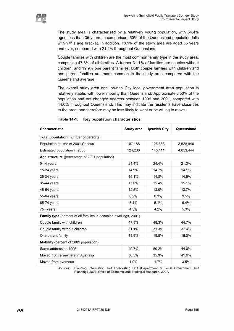
The study area is characterised by a relatively young population, with 54.4% aged less than 35 years. In comparison, 50% of the Queensland population falls within this age bracket. In addition, 18.1% of the study area are aged 55 years and over, compared with 21.2% throughout Queensland.
Couple families with children are the most common family type in the study area, comprising 47.3% of all families. A further 31.1% of families are couples without children, and 19.9% one parent families. Both couple families with children and one parent families are more common in the study area compared with the Queensland average.
The overall study area and Ipswich City local government area population is relatively stable, with lower mobility than Queensland. Approximately 50% of the population had not changed address between 1996 and 2001, compared with 44.0% throughout Queensland. This may indicate the residents have close ties to the area, and therefore may be less likely to want or be willing to move.
Table 14-1: Key population characteristics
Characteristic Study area Ipswich City Queensland
Total population (number of persons)
Population at time of 2001 Census 107,188 126,663 3,628,946
Estimated population in 2006 124,230 145,411 4,053,444
Age structure (percentage of 2001 population)
0-14 years 24.4% 24.4% 21.3%
15-24 years 14.9% 14.7% 14.1%
25-34 years 15.1% 14.8% 14.6%
35-44 years 15.0% 15.4% 15.1%
45-54 years 12.5% 13.0% 13.7%
55-64 years 8.2% 8.3% 9.5%
65-74 years 5.4% 5.1% 6.4%
75+ years 4.5% 4.2% 5.3%
Family type (percent of all families in occupied dwellings, 2001)
Couple family with children 47.3% 48.3% 44.7%
Couple family without children 31.1% 31.3% 37.4%
One parent family 19.9% 18.8% 16.0%
Mobility (percent of 2001 population)
Same address as 1996 49.7% 50.2% 44.0%
Moved from elsewhere in Australia 36.5% 35.9% 41.6%
Moved from overseas 1.9% 1.7% 3.5%
Sources: Planning Information and Forecasting Unit (Department of Local Government and Planning), 2001; Office of Economic and Statistical Research, 2007.
Ipswich to Springfield Public Transport Corridor Study Environmental Impact Study
Page 196
14.2.2 Industry and employment
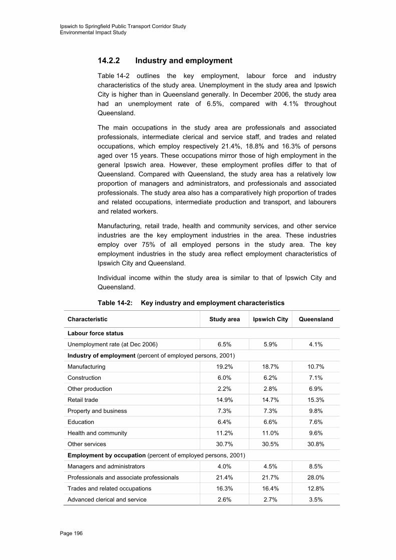
Table 14-2 outlines the key employment, labour force and industry characteristics of the study area. Unemployment in the study area and Ipswich City is higher than in Queensland generally. In December 2006, the study area had an unemployment rate of 6.5%, compared with 4.1% throughout Queensland.
The main occupations in the study area are professionals and associated professionals, intermediate clerical and service staff, and trades and related occupations, which employ respectively 21.4%, 18.8% and 16.3% of persons aged over 15 years. These occupations mirror those of high employment in the general Ipswich area. However, these employment profiles differ to that of Queensland. Compared with Queensland, the study area has a relatively low proportion of managers and administrators, and professionals and associated professionals. The study area also has a comparatively high proportion of trades and related occupations, intermediate production and transport, and labourers and related workers.
Manufacturing, retail trade, health and community services, and other service industries are the key employment industries in the area. These industries employ over 75% of all employed persons in the study area. The key employment industries in the study area reflect employment characteristics of Ipswich City and Queensland.
Individual income within the study area is similar to that of Ipswich City and Queensland.
Table 14-2: Key industry and employment characteristics
Characteristic Study area Ipswich City Queensland
Labour force status
Unemployment rate (at Dec 2006) 6.5% 5.9% 4.1%
Industry of employment (percent of employed persons, 2001)
Manufacturing 19.2% 18.7% 10.7%
Construction 6.0% 6.2% 7.1%
Other production 2.2% 2.8% 6.9%
Retail trade 14.9% 14.7% 15.3%
Property and business 7.3% 7.3% 9.8%
Education 6.4% 6.6% 7.6%
Health and community 11.2% 11.0% 9.6%
Other services 30.7% 30.5% 30.8%
Employment by occupation (percent of employed persons, 2001)
Managers and administrators 4.0% 4.5% 8.5%
Professionals and associate professionals 21.4% 21.7% 28.0%
Trades and related occupations 16.3% 16.4% 12.8%
Advanced clerical and service 2.6% 2.7% 3.5%
Ipswich to Springfield Public Transport Corridor Study Environmental Impact Study
PB 2134204A-RPT020-D:br Page 197
Characteristic Study area Ipswich City Queensland
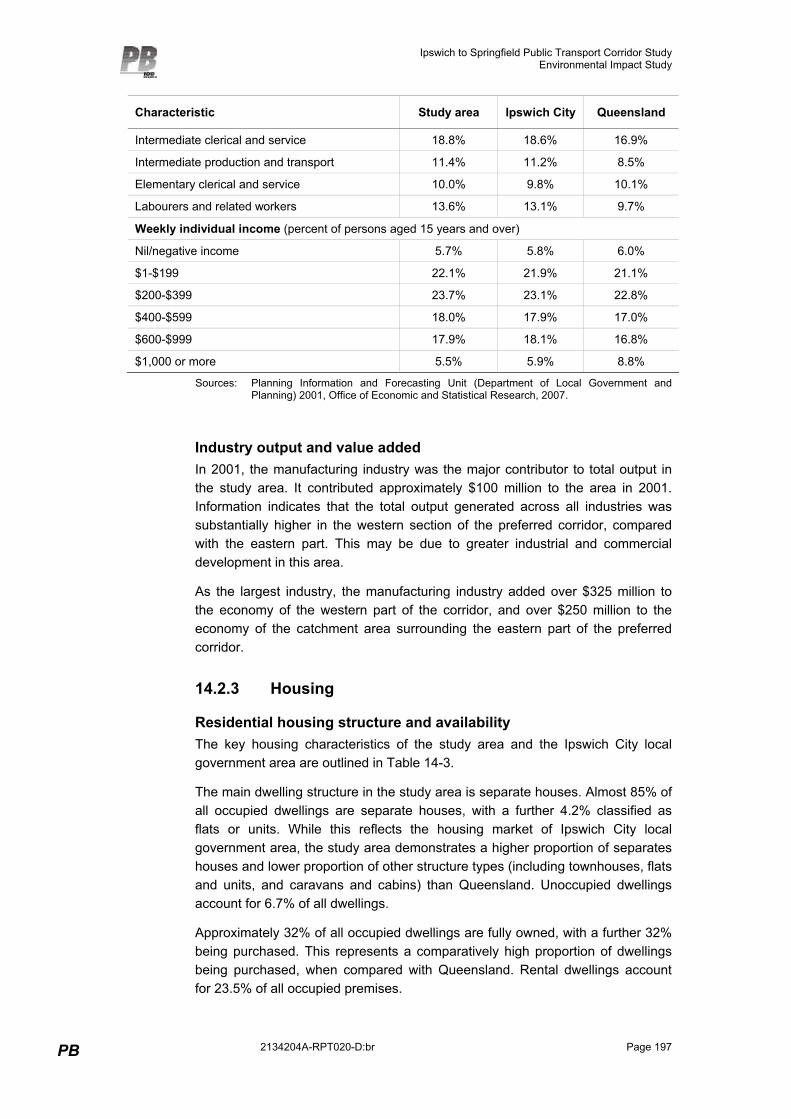
Intermediate clerical and service 18.8% 18.6% 16.9%
Intermediate production and transport 11.4% 11.2% 8.5%
Elementary clerical and service 10.0% 9.8% 10.1%
Labourers and related workers 13.6% 13.1% 9.7%
Weekly individual income (percent of persons aged 15 years and over)
Nil/negative income 5.7% 5.8% 6.0%
$1-$199 22.1% 21.9% 21.1%
$200-$399 23.7% 23.1% 22.8%
$400-$599 18.0% 17.9% 17.0%
$600-$999 17.9% 18.1% 16.8%
$1,000 or more 5.5% 5.9% 8.8%
Sources: Planning Information and Forecasting Unit (Department of Local Government and Planning) 2001, Office of Economic and Statistical Research, 2007.
Industry output and value added In 2001, the manufacturing industry was the major contributor to total output in the study area. It contributed approximately $100 million to the area in 2001. Information indicates that the total output generated across all industries was substantially higher in the western section of the preferred corridor, compared with the eastern part. This may be due to greater industrial and commercial development in this area.
As the largest industry, the manufacturing industry added over $325 million to the economy of the western part of the corridor, and over $250 million to the economy of the catchment area surrounding the eastern part of the preferred corridor.
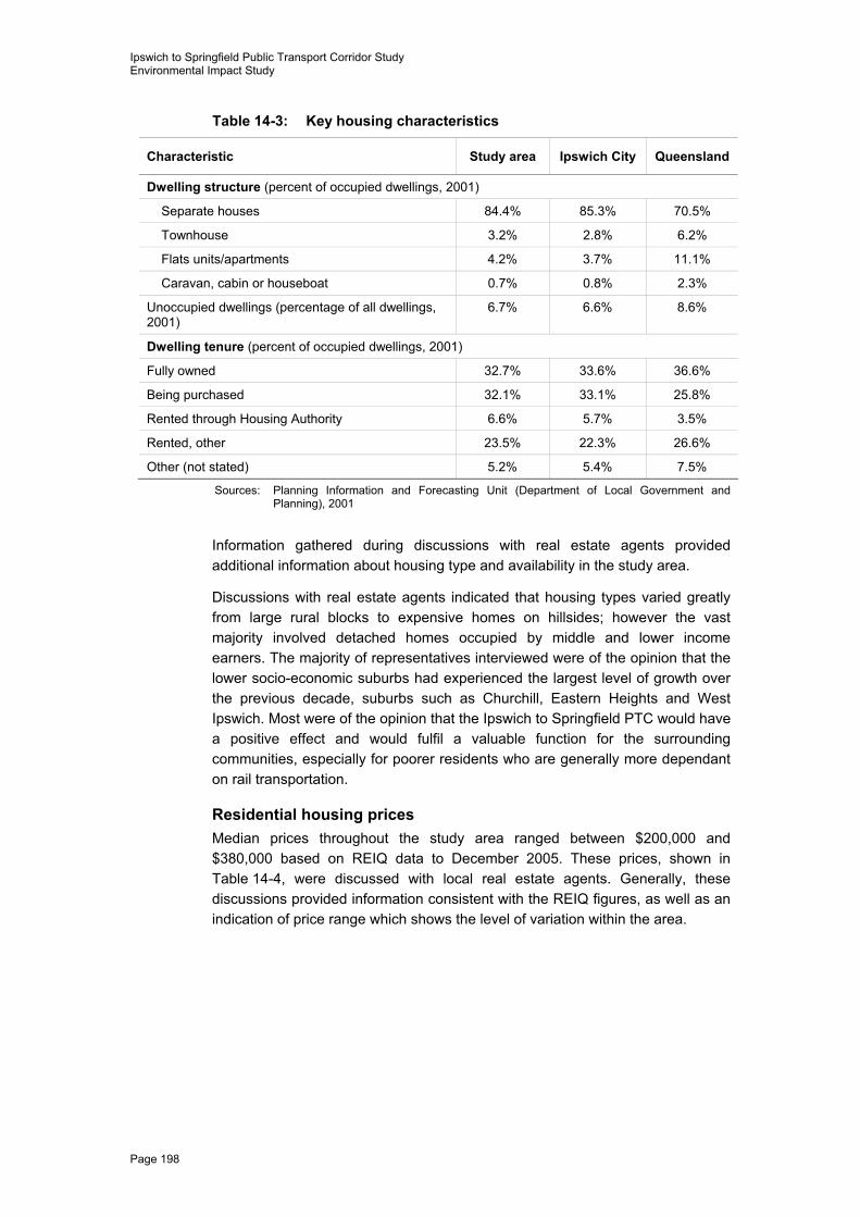
14.2.3 Housing
Residential housing structure and availability The key housing characteristics of the study area and the Ipswich City local government area are outlined in Table 14-3.
The main dwelling structure in the study area is separate houses. Almost 85% of all occupied dwellings are separate houses, with a further 4.2% classified as flats or units. While this reflects the housing market of Ipswich City local government area, the study area demonstrates a higher proportion of separates houses and lower proportion of other structure types (including townhouses, flats and units, and caravans and cabins) than Queensland. Unoccupied dwellings account for 6.7% of all dwellings.
Approximately 32% of all occupied dwellings are fully owned, with a further 32% being purchased. This represents a comparatively high proportion of dwellings being purchased, when compared with Queensland. Rental dwellings account for 23.5% of all occupied premises.
Ipswich to Springfield Public Transport Corridor Study Environmental Impact Study
Page 198
Table 14-3: Key housing characteristics
Characteristic Study area Ipswich City Queensland
Dwelling structure (percent of occupied dwellings, 2001)
Separate houses 84.4% 85.3% 70.5%
Townhouse 3.2% 2.8% 6.2%
Flats units/apartments 4.2% 3.7% 11.1%
Caravan, cabin or houseboat 0.7% 0.8% 2.3%
Unoccupied dwellings (percentage of all dwellings, 2001)
6.7% 6.6% 8.6%
Dwelling tenure (percent of occupied dwellings, 2001)
Fully owned 32.7% 33.6% 36.6%
Being purchased 32.1% 33.1% 25.8%
Rented through Housing Authority 6.6% 5.7% 3.5%
Rented, other 23.5% 22.3% 26.6%
Other (not stated) 5.2% 5.4% 7.5%
Sources: Planning Information and Forecasting Unit (Department of Local Government and Planning), 2001
Information gathered during discussions with real estate agents provided additional information about housing type and availability in the study area.
Discussions with real estate agents indicated that housing types varied greatly from large rural blocks to expensive homes on hillsides; however the vast majority involved detached homes occupied by middle and lower income earners. The majority of representatives interviewed were of the opinion that the lower socio-economic suburbs had experienced the largest level of growth over the previous decade, suburbs such as Churchill, Eastern Heights and West Ipswich. Most were of the opinion that the Ipswich to Springfield PTC would have a positive effect and would fulfil a valuable function for the surrounding communities, especially for poorer residents who are generally more dependant on rail transportation.
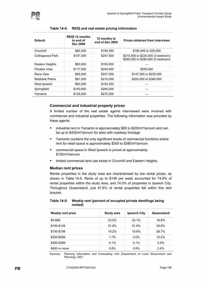
Residential housing prices Median prices throughout the study area ranged between $200,000 and $380,000 based on REIQ data to December 2005. These prices, shown in Table 14-4, were discussed with local real estate agents. Generally, these discussions provided information consistent with the REIQ figures, as well as an indication of price range which shows the level of variation within the area.
Ipswich to Springfield Public Transport Corridor Study Environmental Impact Study
PB 2134204A-RPT020-D:br Page 199
Table 14-4: REIQ and real estate pricing information
Suburb REIQ 12 months
to end of Dec 2000
12 months to end of Dec 2005 Prices obtained from interviews
Churchill $82,000 $194,250 $180,000 to 200,000 Collingwood Park $107,000 $247,500 $210,000 to $220,000 (3 bedroom)
$260,000 to $280,000 (4 bedroom) Eastern Heights $80,000 $193,500 — Flinders View $117,500 $245,000 $255,000 Race View $85,000 $227,000 $147,000 to $235,000 Redbank Plains $81,000 $210,000 $200,000 to $380,000 West Ipswich $63,000 $193,250 — Springfield $150,850 $290,000 — Yamanto $125,000 $270,000 —
Commercial and industrial property prices A limited number of the real estate agents interviewed were involved with commercial and industrial properties. The following information was provided by these agents:
� industrial rent in Yamanto is approximately $85 to $200/m²/annum and can be up to $400/m²/annum for sites with roadway frontage
� Yamanto contains the only significant levels of commercial functions where rent for retail space is approximately $300 to $380/m²/annum
� commercial space in West Ipswich is priced at approximately $150/m²/annum
� limited commercial land use exists in Churchill and Eastern Heights.
Median rent prices Rental properties in the study area are characterised by low rental prices, as shown in Table 14-5. Rents of up to $149 per week accounted for 74.8% of rental properties within the study area, and 74.0% of properties in Ipswich City. Throughout Queensland, just 47.6% of rental properties fall within this rent bracket.
Table 14-5: Weekly rent (percent of occupied private dwellings being rented)
Weekly rent price Study area Ipswich City Queensland
$0-$99 23.0% 22.1% 18.8%
$100-$149 51.8% 51.9% 28.8%
$150-$199 19.2% 19.6% 29.7%
$200-$299 1.7% 2.0% 15.2%
$300-$399 0.1% 0.1% 2.4%
$400 or more 0.8% 0.9% 2.4%
Sources: Planning Information and Forecasting Unit (Department of Local Government and Planning), 2001
Ipswich to Springfield Public Transport Corridor Study Environmental Impact Study
Page 200
This Census data is reflected in information provided by local real estate agents. While information provided during discussion varied, it general highlighted the low rent trends in the area. Real estate agents provided the following information about residential rental prices:
� Churchill is a predominantly low rent area with a typical rent varying between amount of $180 and $210 per week (an approximate estimate)
� approximate rent amounts in Eastern Heights are about $210 per week
� typical rent in Yamanto varies between $210 and $260 per week
� average rent is approximately $240 per week in Raceview
� average rent is approximately $250 per week in Flinders View
� rent prices in West Ipswich vary between $200 and $220 per week for a three bedroom house.
14.2.4 Social services and infrastructure
Health facilities and services An extensive and integrated health care system is available to the Ipswich community incorporating both private and public services.
The West Moreton Health Service District’s Ipswich Hospital is a 310 bed facility servicing the entire West Moreton District and providing a range of general services including medical, surgical, maternity, general outpatients and 24-hour emergency care.
The hospital also offers specialised services such as:
� orthopaedics
� oncology
� obstetrics
� gynaecology
� rheumatology
� paediatrics
� psychiatry
� ophthalmology
� neurosurgery
� burns
� rehabilitation.
As part of the local health district a range of allied health services for audiology, speech pathology, physiotherapy, occupational therapy, dietetics and social work are offered along with general community health services. The hospital also offers oral health care and radiography services.
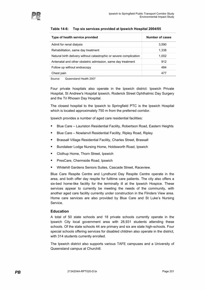
In the 2004/05 financial year 32,263 people were admitted to Ipswich Hospital. A further 255,472 non-admitted cases were managed by the hospital during this time. Table 14-6 summarises the top six services provided at Ipswich Hospital in 2004/05.
Ipswich to Springfield Public Transport Corridor Study Environmental Impact Study
PB 2134204A-RPT020-D:br Page 201
Table 14-6: Top six services provided at Ipswich Hospital 2004/05
Type of health service provided Number of cases
Admit for renal dialysis 3,590
Rehabilitation, same day treatment 1,338
Natural birth delivery without catastrophic or severe complication 1,002
Antenatal and other obstetric admission, same day treatment 912
Follow up without endoscopy 484
Chest pain 477
Source: Queensland Health 2007
Four private hospitals also operate in the Ipswich district: Ipswich Private Hospital, St Andrew's Hospital Ipswich, Roderick Street Ophthalmic Day Surgery and the Tri Rhosen Day Hospital.
The closest hospital to the Ipswich to Springfield PTC is the Ipswich Hospital which is located approximately 750 m from the preferred corridor.
Ipswich provides a number of aged care residential facilities:
� Blue Care – Lauriston Residential Facility, Robertson Road, Eastern Heights
� Blue Care – Nowlanvil Residential Facility, Ripley Road, Ripley
� Brassall Village Residential Facility, Charles Street, Brassall
� Bundaleer Lodge Nursing Home, Holdsworth Road, Ipswich
� Clothup Home, Thorn Street, Ipswich
� PresCare, Chermside Road, Ipswich
� Whitehill Gardens Seniors Suites, Cascade Street, Raceview.
Blue Care Respite Centre and Lyndhurst Day Respite Centre operate in the area, and both offer day respite for fulltime care patients. The city also offers a six-bed home-like facility for the terminally ill at the Ipswich Hospice. These services appear to currently be meeting the needs of the community, with another aged care facility currently under construction in the Flinders View area. Home care services are also provided by Blue Care and St Luke’s Nursing Service.
Education A total of 50 state schools and 18 private schools currently operate in the Ipswich City local government area with 28,931 students attending these schools. Of the state schools 44 are primary and six are state high-schools. Four special schools offering services for disabled children also operate in the district, with 314 students currently enrolled.
The Ipswich district also supports various TAFE campuses and a University of Queensland campus at Churchill.
Ipswich to Springfield Public Transport Corridor Study Environmental Impact Study
Page 202
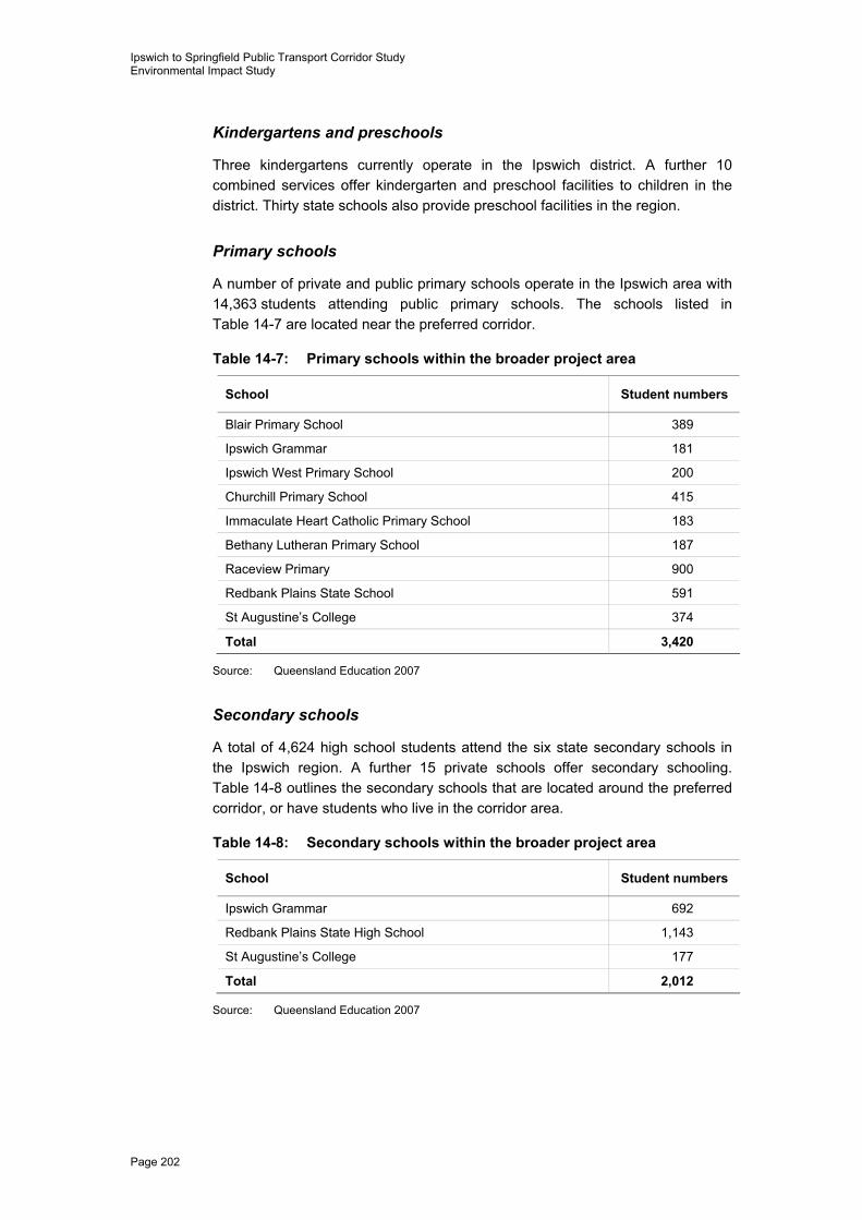
Kindergartens and preschools
Three kindergartens currently operate in the Ipswich district. A further 10 combined services offer kindergarten and preschool facilities to children in the district. Thirty state schools also provide preschool facilities in the region.
Primary schools
A number of private and public primary schools operate in the Ipswich area with 14,363 students attending public primary schools. The schools listed in Table 14-7 are located near the preferred corridor.
Table 14-7: Primary schools within the broader project area
School Student numbers
Blair Primary School 389
Ipswich Grammar 181
Ipswich West Primary School 200
Churchill Primary School 415
Immaculate Heart Catholic Primary School 183
Bethany Lutheran Primary School 187
Raceview Primary 900
Redbank Plains State School 591
St Augustine’s College 374
Total 3,420
Source: Queensland Education 2007
Secondary schools
A total of 4,624 high school students attend the six state secondary schools in the Ipswich region. A further 15 private schools offer secondary schooling. Table 14-8 outlines the secondary schools that are located around the preferred corridor, or have students who live in the corridor area.
Table 14-8: Secondary schools within the broader project area
School Student numbers
Ipswich Grammar 692
Redbank Plains State High School 1,143
St Augustine’s College 177
Total 2,012
Source: Queensland Education 2007
Ipswich to Springfield Public Transport Corridor Study Environmental Impact Study
PB 2134204A-RPT020-D:br Page 203
Community services and facilities
Community care services
A number of community services exist in Ipswich offering a variety of support groups for community members. Most of the services are in the Ipswich City centre requiring travel for community members attending a group. Support groups in the area include:
� Alzheimer’s Support Group
� Arthritis
� Association of Independent Retirees
� Breast Cancer Support Group
� Breathe Easy Social Group
� Cancer Friendship Group
� Diabetes Support Group
� Goodna Women’s Group
� Healthy Older Persons
� Ipswich Carers Support Group
� Panic and Anxiety Disorder Group
� Parkinson’s Disease Support Group
� Stroke Support Group
� Vision Impairment Support Group.
Other services operating in the area include the Ipswich Community Access Disability Services, the Ipswich Community Aid and the Community Visitors Scheme.
There are a number of community centres located in the broader Ipswich area, with the Leichhardt Community Centre located in close proximity to the northern part of the preferred corridor.
Community organisations and groups
A wide range of community groups providing social interaction and community support operate in the Ipswich area including:
� service clubs, such as numerous Rotary, Apex and Lions clubs
� seniors groups, including 60s and Better Program, National Seniors, and Senior Citizens Club of Ipswich
� legacy clubs, Returned Services League and War Widows clubs
� women’s associations, including Queensland Country Women’s Association and Zonta Club.
Ipswich to Springfield Public Transport Corridor Study Environmental Impact Study
Page 204
Recreational and sporting groups and facilities A wide range of sporting and recreational facilities are available to the people of Ipswich and surrounding areas, including:
� Brothers Leagues Club Ipswich
� Ipswich and West Moreton BMX Club
� Ipswich Bowls Club
� Ipswich Croquet Club
� Ipswich District Junior Tennis Association
� Ipswich Netball Association
� Ipswich Hockey Association Inc
� Ipswich Racecourse
� Ipswich Rugby Union Club
� Ipswich Softball Association
� Ipswich Table Tennis Association
� Police Citizens Youth Clubs (PCYC)
� Queensland Raceway Willowbank
� Redbank Plains Golf Club
� Ipswich Golf Club
� Ipswich Greyhound Racing Club.
14.2.5 Community access and public transport
Travel characteristics such as the use of existing public transport facilities as well as car ownership are outlined in Table 14-9. The broader desktop study and consultation feedback provided further information on the community’s current access to goods and services, such as shopping centres, health care and schools.
Current travel patterns The most common method of travel to work in both the study area and Ipswich City local government area is by car, as either driver or passenger. Approximately 70% of all employed persons in the study area travel to work by car. In comparison, only 64.9% of employed persons throughout Queensland travel to work by car. Train was the second most common method of travel to work, however only 3.9% use this form. Bus was used by 0.4% of persons in the study area, compared with 2.4% throughout Queensland.
Car ownership characteristics of the study area are similar to both Ipswich City local government area and Queensland. Approximately 90% of occupied private dwellings have one or more motor vehicles. Almost 40% of dwellings have one car, with a further 33.2% of households having two cars.
Ipswich to Springfield Public Transport Corridor Study Environmental Impact Study
PB 2134204A-RPT020-D:br Page 205
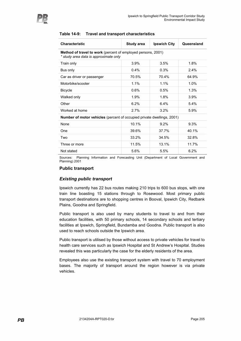
Table 14-9: Travel and transport characteristics
Characteristic Study area Ipswich City Queensland
Method of travel to work (percent of employed persons, 2001) * study area data is approximate only
Train only 3.9% 3.5% 1.8%
Bus only 0.4% 0.3% 2.4%
Car as driver or passenger 70.5% 70.4% 64.9%
Motorbike/scooter 1.1% 1.1% 1.0%
Bicycle 0.6% 0.5% 1.3%
Walked only 1.9% 1.8% 3.9%
Other 6.2% 6.4% 5.4%
Worked at home 2.7% 3.2% 5.9%
Number of motor vehicles (percent of occupied private dwellings, 2001)
None 10.1% 9.2% 9.3%
One 39.6% 37.7% 40.1%
Two 33.2% 34.5% 32.8%
Three or more 11.5% 13.1% 11.7%
Not stated 5.6% 5.5% 6.2%
Sources: Planning Information and Forecasting Unit (Department of Local Government and Planning) 2001
Public transport
Existing public transport
Ipswich currently has 22 bus routes making 210 trips to 600 bus stops, with one train line boasting 15 stations through to Rosewood. Most primary public transport destinations are to shopping centres in Booval, Ipswich City, Redbank Plains, Goodna and Springfield.
Public transport is also used by many students to travel to and from their education facilities, with 50 primary schools, 14 secondary schools and tertiary facilities at Ipswich, Springfield, Bundamba and Goodna. Public transport is also used to reach schools outside the Ipswich area.
Public transport is utilised by those without access to private vehicles for travel to health care services such as Ipswich Hospital and St Andrew’s Hospital. Studies revealed this was particularly the case for the elderly residents of the area.
Employees also use the existing transport system with travel to 70 employment bases. The majority of transport around the region however is via private vehicles.
Ipswich to Springfield Public Transport Corridor Study Environmental Impact Study
Page 206
14.2.6 Local community values, lifestyle and attitudes
The information provided by potentially affected property owners and community stakeholders through interviews and feedback forms has been used to assess the local community values and lifestyles of the study area. A desktop review of the Ipswich City Council website and other related sites was also completed. This ensured public opinion on values within the community was gauged.
Due to the diversity of the Ipswich community many recognise the city’s residents as being community minded and socially responsible. According to the Ipswich City Council website (2006) the city boasts strong cultural influences and its residents are proud supporters of community and voluntary organisations, from the provision of essential emergency services to the care of frail and vulnerable residents. Many regard the community as one of its greatest assets due to the willingness of residents to pull together to solve common problems in the area.
The many community groups and support associations have formed an effective network of community services and infrastructure which many believe is enabling Ipswich to establish itself as a growing city. This belief was reinforced by community members during community consultation activities.
Consultation with residents identified the high heritage value of some areas, particularly the area which was originally known as Little Ipswich.
As an industrial and business area, one of the greatest values highlighted by owners and community members in relation to the western part of the study area was the road access provided for businesses. Most businesses in this area have been established for many years and believe that locational stability is beneficial to their economic stability.
The eastern part of the preferred corridor traverses largely rural land with little development. The local communities in this area were positive, with many looking towards the future and the potential the region holds for future development. Many believe it has value as an area that will prosper in the years to come and a public transport system would contribute to this for local residents and school children. Several participants did raise concerns about the protection of the environment in the area and greatly valued this aspect of their region.
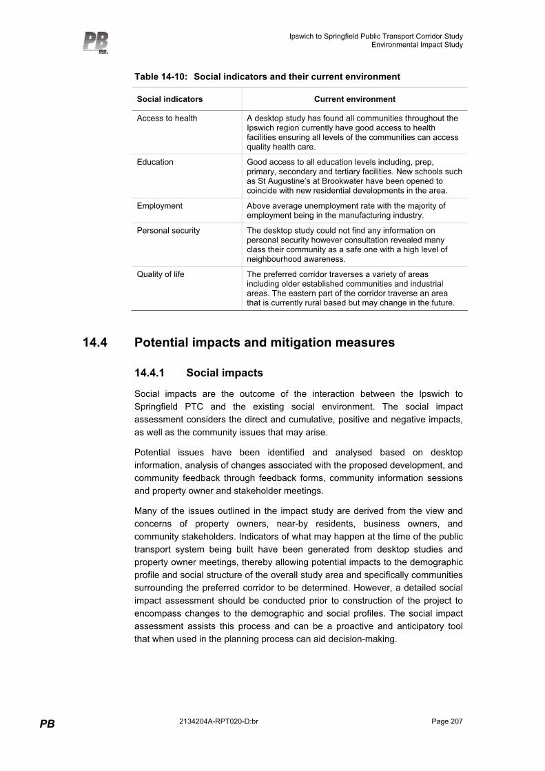
14.3 Social indicators Social indicators can be defined as statistics and statistical evidence that enables society to assess where it stands and where it is going with respect to their values and goals (Noll, n.d.). The main goal of social indicators is to monitor social change and measure society’s welfare as to whether things remain equal, have improved or a “community” is now better off.
The regular observation and analysis of social change will ensure infrastructure is remaining beneficial to a community and encouraging positive futures (refer to Table 14-10).
Ipswich to Springfield Public Transport Corridor Study Environmental Impact Study
PB 2134204A-RPT020-D:br Page 207
Table 14-10: Social indicators and their current environment
Social indicators Current environment
Access to health A desktop study has found all communities throughout the Ipswich region currently have good access to health facilities ensuring all levels of the communities can access quality health care.
Education Good access to all education levels including, prep, primary, secondary and tertiary facilities. New schools such as St Augustine’s at Brookwater have been opened to coincide with new residential developments in the area.
Employment Above average unemployment rate with the majority of employment being in the manufacturing industry.
Personal security The desktop study could not find any information on personal security however consultation revealed many class their community as a safe one with a high level of neighbourhood awareness.
Quality of life The preferred corridor traverses a variety of areas including older established communities and industrial areas. The eastern part of the corridor traverse an area that is currently rural based but may change in the future.
14.4 Potential impacts and mitigation measures
14.4.1 Social impacts
Social impacts are the outcome of the interaction between the Ipswich to Springfield PTC and the existing social environment. The social impact assessment considers the direct and cumulative, positive and negative impacts, as well as the community issues that may arise.
Potential issues have been identified and analysed based on desktop information, analysis of changes associated with the proposed development, and community feedback through feedback forms, community information sessions and property owner and stakeholder meetings.
Many of the issues outlined in the impact study are derived from the view and concerns of property owners, near-by residents, business owners, and community stakeholders. Indicators of what may happen at the time of the public transport system being built have been generated from desktop studies and property owner meetings, thereby allowing potential impacts to the demographic profile and social structure of the overall study area and specifically communities surrounding the preferred corridor to be determined. However, a detailed social impact assessment should be conducted prior to construction of the project to encompass changes to the demographic and social profiles. The social impact assessment assists this process and can be a proactive and anticipatory tool that when used in the planning process can aid decision-making.
Ipswich to Springfield Public Transport Corridor Study Environmental Impact Study
Page 208
Demographic changes Since the 2001 Census, it is believed that the population characteristics of the Ipswich region have not changed dramatically. It is known that the population has increased since the ABS last gathered its information in 2001, and this is expected to continue to grow into the future.
The Ipswich region is currently undergoing a development boom, with an extra 100,000 people expected to move to the Ripley Valley area in the next decade or so due to the development of this area and the planned Ripley Valley Town Centre. This actual and projected population growth has brought about the need for high quality public transport in the area.
Development of the Ipswich to Springfield PTC is not expected to change the population characteristics of the area, including occupations, age profiled or sex. A small increase of males residing in certain areas and increase in trade-based works may occur associated with construction of the development.
It is unlikely that the Ipswich to Springfield PTC would encourage a loss of population. Other studies conducted in the Ipswich region have shown that the Brisbane/Ipswich corridor is designated as one of Queensland’s major growth areas under the SEQRP. If a transport corridor was to go ahead there was very little indication from community members that they would leave the Ipswich region. Many indicated that it was positive to see this type of future planning occurring but as long as it did not affect their residential community or business. Many also felt the planning would benefit population growth in the region and benefit the local community in the long-term.
General social impacts
Community lifestyle and values
The social profile of a community identifies the character, identity or activities of a group or community that makes it unique. The Ipswich to Springfield PTC may have both positive and negative impacts on these values and lifestyles.
A public transport system would improve accessibility and enhance access to community and other social services. This improved access to important amenities such as schools, hospitals and sporting facilities may improve the quality of life of current and future residents, particularly those such as the elderly who are currently unable to access such services.
Many potentially affected property owners raised concerns about impacts on their lifestyle. Residents, particularly those in the western part of the preferred corridor, appreciate the peaceful settings offered by the local area. They enjoy the atmosphere of the area, and many consider it a good area to retire or raise a family. Some felt changes associated with the Ipswich to Springfield PTC would be detrimental to property values, safety, amenity and loss of neighbourhood.
The eastern part of the preferred corridor is set in a predominantly a rural area, identifying with country-style setting offering peace and quiet to its residents. In this area, residents are more supportive of the project. The majority of land is owned by developers and the earmarking of a corridor in this area would benefit
Ipswich to Springfield Public Transport Corridor Study Environmental Impact Study
PB 2134204A-RPT020-D:br Page 209
their residential developments in the future by providing easy access for families to good schools and shopping facilities. Many feel a public transport system would encourage growth in this study area.
Business resumptions and resultant financial impacts, particularly in the western part of the study area, may impede the lifestyle of business owners and their employees. Business owners and the local community may feel financially worse off and be concerned about perceived negative impacts on their future, their families and employees. However, public transport through this area may also provide positive outcomes, with improved access to businesses for both employees and customers.
Safety
Some traffic access will be required to the preferred corridor during the construction phase. The use of local roads, particularly by heavy vehicles, may reduce safety during construction. The implementation of a traffic management plan, developed in consultation with local residents and the community, may assist to maintain and improve road safety.
There may be safety concerns during the operational phase of the project. There may be a higher rate of crime, including property damage or graffiti at station locations, and vehicle break-in and theft at parking facilities. This in turn may reduce safety for potential commuters. Provision of safety mechanisms, such as video surveillance at stations and presence of staff, may assist to reduce crime and improve safety. Principles that should be incorporated into the design of stations along the preferred corridor to reduce the opportunity for and likelihood of crime are discussed further in Section 16.2.
Amenity
During construction, the Ipswich to Springfield PTC may result in changes to local amenity particularly through increased levels of dust, noise and vibration. These impacts are likely to be associated with clearing and site preparation, construction activities and truck movements. While some impacts will be localised to nearby residents, other impacts such as truck movements on local roads, may be experienced by the broader Ipswich community.
Following construction, local residents may experience ongoing amenity impacts during the operational phase of the Ipswich to Springfield PTC. It is likely that these impacts, such as vibration and noise of trains, will be experienced by nearby residents only. Other noise sources, such as people walking to and from the station and traffic around park-and-ride facilities may impact on immediate residents.
Air quality, noise and vibration impacts, as well as relevant mitigation measures, are discussed in Chapters 9 and 10 respectively.
Implementation of the Ipswich to Springfield PTC would also result in changes to the landscape and visual character of the area. These impacts will be more prominent in areas where the alignment is raised, at station locations where
Ipswich to Springfield Public Transport Corridor Study Environmental Impact Study
Page 210
additional structures and buildings are required, and in areas, where there is little other infrastructure or linear development.
Access and severance
The Ipswich to Springfield PTC would provide much improved public transport to the community, by providing both improved local and regional connection and accessibility. Local residents will have greater public transport access to essential services and facilities such as education and medical services, as well as retail and commercial businesses. Residents will also be afforded easier access to regional areas, particularly Brisbane which may offer a broader range and more specialised services than the local area. Business owners in the study area may also benefit from increased accessibility to their business from the broader community.
However, the project may result in severance of small communities. Previously continuous communities may be divided by the preferred corridor, with no access between households who were originally near neighbours. This may alter the social network of residents and sever communities.
Due to the design of the Ipswich to Springfield PTC which include numerous elevated sections where the corridor will be built on structure, as well as several areas where the preferred corridor will pass through landscape cuttings, cyclist and pedestrian access will be limited in the vicinity of the preferred corridor, except at stations.
Housing
The creation of efficient transportation links between home and work may generate demand for housing in much of the Ipswich area. Discussions with real estate agents highlighted the links between public transport and the demand for housing and other real estate.
The lack of availability of rental properties and the rising prices of land has made finding adequate housing for some residents difficult. Development of the preferred corridor may lead to an increase in the housing price, forcing many existing residents to move away, stretching work and social connections, and preventing new home owners from entering the market. Consultation indicated that house prices in Ripley have risen recently due to the prospect of the Ipswich to Springfield PTC being implemented.
Impacts on affected property owners Development of the Ipswich to Springfield PTC would require acquisition of an easement varying from 20 m – 120 m wide through the preferred corridor area. Additional space would also be required at designated station locations and park and rides. Approximately 169 private properties are affected by the preferred corridor. While an alignment has been developed, any of these properties may be directly affected by future project requirements. Impacts on properties are likely to vary from minor land acquisition to loss of houses and resumption of whole properties.
Ipswich to Springfield Public Transport Corridor Study Environmental Impact Study
PB 2134204A-RPT020-D:br Page 211
Compensation and consultation with land owners
During subsequent detailed planning, Queensland Transport will consult with each potentially affected landowner to discuss location of the preferred corridor, stations and easement, access and construction activities. Discussions will also address compensation.
The Queensland Government will compensate affected landowners in accordance with the Acquisition of Land Act 1967, Part 4. Under this legislation, compensation is provided to ensure that the financial circumstances of directly affected property owners are no worse than prior to acquisition of the corridor. While acquisition usually occurs just prior to construction, if hardship is demonstrated by the land owner, an early acquisition process may be considered.
Impacts to property owners and residents
The project will impact on properties and residences. These impacts, and the acquisition of land, may cause displacement of people and affect residents through:
� disruption to lifestyle
� severance of communities and loss of social networks and relationships
� emotional upset
� changes to and uncertainty about future plans.
The emotion and financial cost of relocating may bring about distress to property owners. In addition to seeking alternative housing and physically relocating, the necessity of making decisions about their future arises. Uncertainty about project timing, and financial uncertainty about compensation, may heighten anxiety. Potentially affected residents may experience further emotion/stress if they put future plans on hold, while waiting for a project to commence. This may prevent people moving to other areas, or discourage people from further developing or improving their properties.
The community surrounding the western part of the preferred corridor identifies itself as a predominantly business focused area, which may face impacts in the form of the loss of some well-established businesses as a result of the Ipswich to Springfield PTC. Many of the property owners which may potentially be affected have been operating in their current location for over 15 years, with several operating as family-run businesses which ultimately support several families, along with a number of employees. Owners feel they are well established and known at their current locations, and relocation may reduce business and impact on long-term viability.
Ongoing communication, consultation and liaison with property owners will ensure they are aware of project developments and timeframes, as well as the progression of property resumption and compensation.
Ipswich to Springfield Public Transport Corridor Study Environmental Impact Study
Page 212
Summary of mitigation strategies Public transport corridor selection and preservation is a complex process which must incorporate a balanced approach in mitigating social and environmental issues. It is recognised that mitigation and management strategies must go beyond the usual efforts and include the full attention and participation of both the affected community and the government.
Planning for corridor preservation should start early and proactively seek out potential social issues during the preservation phase, Environmental Impact Assessment phase, and construction phase and encourage communications between the community and government to develop effective and achievable solutions.
The following section outlines key aspects for an overall mitigation strategy which addresses the key social impacts outlined. While individual strategies have not been recommended for specific issues, overall strategies, incorporating recognition of key impacts have been recommended, and these provide an action list for Queensland Transport to consider in the lead-up to the corridor preservation, Environmental Impact Assessment and construction phases.
Communication and awareness
Throughout the consultation process, property owners and community stakeholders identified communication as a key step in assisting the community through the corridor protection and Environmental Impact Assessment and construction phases of a public transport corridor. Community members feel that open and honest communication would provide them with the best opportunity to make timely decisions about their future and the needs of the community. Many felt this study was “thrown on them” with no thought as to the “shock factor” involved in a study of this nature. Communication that focuses on the evolving plans of corridor protection and future construction and the role the community must play, could be provided at key milestones before, during and after this planning has been put in place.
Communicating key decisions to the community would help to build trust between the community, the government, and its employees. This would also serve to remove angst and concern for those who are going to be directly affected.
Strong communication with affected property owners may also assist in lessening the severity of impacts, including uncertainty, difficulty in planning for the future, concerns about the compensation process and distrust for the project. To minimise impacts on residents’ lifestyles, business and community activities during construction, property owners should be provided with appropriate notice about the type and timing of work to be undertaken on or near their property.
Communication could focus on the benefits expected from a public transport system such as increased access to services, business opportunities, population increases and a loop network system connecting to Springfield and Brisbane. It would also be advisable to report how the community’s feedback is playing a role in the planning and design of the preferred corridor and its structure.
Ipswich to Springfield Public Transport Corridor Study Environmental Impact Study
PB 2134204A-RPT020-D:br Page 213
Education would play a vital role in helping the community understand the need for a public transport system. As an area that relies heavily on private modes of transport, an educational program promoting the features and affordability of the system would be beneficial to the final construction phase and the community.
A continual open door policy for community contact with the study team would also be beneficial. This would foster relationship building and trust with the Ipswich community. This is more important for this project as the timeline for construction of the system is not yet confirmed and this in itself has the possibility of causing long-term anxiety for affected owners.
Overall the community will benefit from information updates regarding the process and progress of the project, and from information detailing how identified impacts are being addressed in response to the community’s concern. To minimise the impacts on residents’ lifestyles, business and community activity and local access during the construction phase of the Ipswich to Springfield PTC, property owners and the community should also be provided with appropriate notice about the type and timing of work to be undertaken on or near their property.
Amenity
The assessment found with elevated levels of dust that, if not managed properly, air quality may be a concern during construction. Mitigation measures such as limiting the amount of cleared area, erecting physical barriers, site traffic control, earth moving management, watering sprays, soil compaction and vegetative stabilisation would be required during the construction phase to allay any health concerns from residents and businesses.
Depending on the final decision regarding the mode of transport, measures would also need to be put in place to mitigate any concerns held by nearby residents and businesses.
Beautification of the areas where structures are visible would be necessary for visual impacts. Design of the structure and barriers should aim to complement the existing area and trees/shrubs planted to shield areas that are exposed, especially in residential areas.
14.4.2 Economic impacts
SGS Economics and Planning was appointed to undertake the economic assessment of the Ipswich to Springfield PTC. Tangible and intangible economic costs and benefits associated with the preferred corridor are outlined in the following sections.
Importance of public transport on emerging trends The provision of an efficient, functioning public transport system can have a significant effect on urban economic trends by causing modal shifts in resident’s travel habits. The movement away from private vehicle usage towards bus and rail transportation reduces travel cost, reduces energy expenditure and allows for greater population densities. Effective public transport systems promote
Ipswich to Springfield Public Transport Corridor Study Environmental Impact Study
Page 214
heightened interregional interaction, stimulating business activity and access to services. On a social level it can help reduce community isolation, providing cheap transportation to various socio-economic groups. From a functional view point, public transport adds extra capacity to the road network carrying capacity, accommodating future growth and reducing the need for additional road infrastructure investment. The following section outlines a series of major urban trends and the impact of public transport provision.
Retail supply trends
� Retail shops in a central area rely on obtaining customer exposure from surrounding residential areas to maximise sales. High densities and large pedestrian movements result in a higher customer base, and subsequently, higher sales and follow-on benefits.
� Public transport provides an efficient medium by which large numbers of consumers can be brought to dense, clustered retail centres and then have easy pedestrian access to nearby retail shops. Subsequently, denser, clustered retail is made viable and ultimately results in greater efficiency in land use.
� Strip retail is largely dependant on motor vehicle access and generally develops in areas of low density without significant pedestrian flows. Such development ultimately limits the effective utilisation of space and transportation infrastructure and creates future problems in obtaining higher densities. Through the provision of heightened public transport levels, retail facilities are afforded higher consumer access, and are subsequently permitted to develop in a manner concurrent with efficient land use.
Knowledge based industries
� Effective, functioning public transport systems in urban spaces appeal to moderate to high income earning knowledge workers who value efficient, working systems.
� Improved living conditions attract a wealthier knowledge worker population usually causing increased housing prices, given that employment and economic conditions are supportive.
� Knowledge based industries are typically located in or around dense centres making the existence of a public transport system an efficient method of commuting.
Services sector activities
� Public transport creates the preconditions for tourism by providing local transportation to places of interest and access to interregional tourist markets.
� Public transport provides wider access to superior central recreational centres in densely developed areas, reducing the dependence upon local, less developed recreational centres.
Ipswich to Springfield Public Transport Corridor Study Environmental Impact Study
PB 2134204A-RPT020-D:br Page 215
� Public transport provides access for a wider range of recreational user which aids in creating an inclusionary community.
Cultural and creative industries
� Public transport offers artists and creative young people of limited financial means a mode of affordable transport.
� Public transport provides basic transportation in densely populated areas where cultural and creative activities function best and are often located.
� The provision of affordable transportation allows for creative individuals to travel, promoting the exchange of ideas and the spread of these industries into new urban areas.
Evolution of education
� Public transport provides a means of transportation for young people unable to afford private transport.
� With a larger number of low income earners having access to education opportunities, skilled and knowledge employees become more widespread which has beneficial effects on the regional economy.
� Public transport caters well for students who travel to a single educational centre that does not require the flexibility of movement offered by private transport.
Home business activities
� Public transport provides a link with central business hubs and business markets making home business feasible and reducing the cost of separation from these functions.
� Public transport provides home business operators with access to clients and customers.
� Public transport provides home business operators with access to larger, centralised support services.
Public transport is one of many factors that can influence the course of emerging economic and societal trends. Nevertheless, given the significant change in function between private vehicle dependant systems and public transport systems, the effects are important to recognise. The nodal configuration on public transportation results in high concentrations of pedestrian traffic that compliments dense central commercial hubs increasing retail exposure. The cheap costs associated with this form of transport also provide lower socio-economic groups and young people with the means to affordably travel over a wider distance to access employment and other services. The impact of public transport on emerging trends are evident at the local level but more importantly, it is important to realise that the implementation of public transport infrastructure has far reaching implications for regional emerging trends.
Ipswich to Springfield Public Transport Corridor Study Environmental Impact Study
Page 216
Tangible economic costs and benefits
Reduced growth in road accidents
The Ipswich to Springfield PTC is likely to see a switch to public transport from private vehicle usage and therefore it is likely that there will be reduced costs and growth in road accidents. Calculation of the extent of this benefit is generally based on a rate of accident per million kilometres saved multiplied by the cost associated with different levels of accidents, such as fatal, critical, severe (life threatening), severe other, moderate, minor, and property damage only.
In the case of the Ipswich to Springfield PTC the extent of this impact will however be determined by future population growth in the region. Given high rate of population growth predicted for the area (4.4% per annum) it is likely that any benefits from the Ipswich to Springfield PTC will be offset by increased traffic generation brought about through an increased population.
Industry concentration effects
In the rapidly evolving economy of the 21st century, the ability of small and medium size enterprises (SMEs) to actively engage each other in co-operative resource management and research will direct economic growth. The biggest gains can be made in a firm that most effectively leverages up human capital and information transfer. The firms that are currently based on ‘global knowledge flows’ such as computing, marketing and technical services operate best in regional specific nodes. The firms that exist in these nodes utilise their geographic concentration to reduce the marginal costs of ancillary services as well as to develop networks of business-to-business interaction. This is the notion of connectivity.
With geographical concentration becoming crucial in these high knowledge areas of the economy, it is important for a public transport system to help reduce the time it takes to move throughout these nodes. The Western Corridor does not have highly developed concentrations of such global knowledge activity, although this seems to be emerging in Springfield and to a lesser extent the Ripley Valley area. The new city loop service created by this public transport corridor will provide a high level of connectivity between nodes of activity within the region, and also to Brisbane City.
Connectivity and a central node base are crucial for the emergence of knowledge activity in the future urban areas identified in the Ipswich City Local Planning Scheme. The proposal rightly projects the preferred corridor through the Springfield Town Centre and then through the Ripley Valley area. These two regional economic activity centres demonstrate a suitable geographic position having to access human capital and business contact from the local area and along the corridor necessary for knowledge activity growth.
The overall impact of improved connectivity amongst firms will be dependent on the number of jobs and firms likely to emanate in the corridor.
Ipswich to Springfield Public Transport Corridor Study Environmental Impact Study
PB 2134204A-RPT020-D:br Page 217
Social connectivity benefits
The Ipswich to Springfield PTC is likely to reduce the time taken to travel to key employment hubs for high unemployment centres. By reducing the travel times, the cost of both searching for new work and the costs of working are reduced.
Tourism improvements
Depending on location and available points of interest, public transport corridors can increase the opportunities associated with accessing recreational and tourism infrastructure. There is a limited amount of information available to assess the total effect of additional benefits for tourism in the region. However, should the Springfield Regional Park (Mountain Creek Parklands) be developed to its intended design brief, tourism benefits may arise.
Economic impacts from construction
The economic impacts from construction and the subsequent multiplier or flow on effects can be determined based on the estimated capital costs.
One element of the impacts arising from the Ipswich to Springfield PTC is the direct and flow-on economic effects resulting from the expenditure on infrastructure, as detailed in Chapter 5 of this document. This section looks at the impact of this expenditure on the south-east Queensland regional economy.
The direct effects to the economy are the actual expenditure on the infrastructure. In order to measure the flow on effects of this expenditure demand side multipliers are most commonly used. These are used to evaluate change in the economy given investment in an industry (in this case investment in infrastructure).
It is assumed that in the first instance the investment on infrastructure flows to the construction sector. In addition, for the purpose of the analysis it is assumed that the geographical distribution of expenditure is within south-east Queensland for public transport type (i.e. bus or train). The demand side multipliers can be derived by examining the products and services (e.g. in this case construction supplies, contractors, transport and storage etc.) that the sector under investigation needs to purchase in order to meet production requirements – in this case, the construction sector. If production levels increase, then the suppliers to the construction sector must increase their production levels to meet demand and must purchase more products and services, including labour inputs (i.e. employees) as a result.
The demand side multiplier for the construction sector at the south-east Queensland regional level is 2.7, and thus a flow on of 1.7. This implies that if construction sector increase demand (production) by $1, it requires the south-east Queensland economy to generate $2.70 worth of goods and services (the total multiplier) that eventually supply the construction sector. The $1.70 flow-on effect plus the initial increase in $1 of production totals an overall increase of $2.70 in the south-east Queensland regional economy.
Ipswich to Springfield Public Transport Corridor Study Environmental Impact Study
Page 218
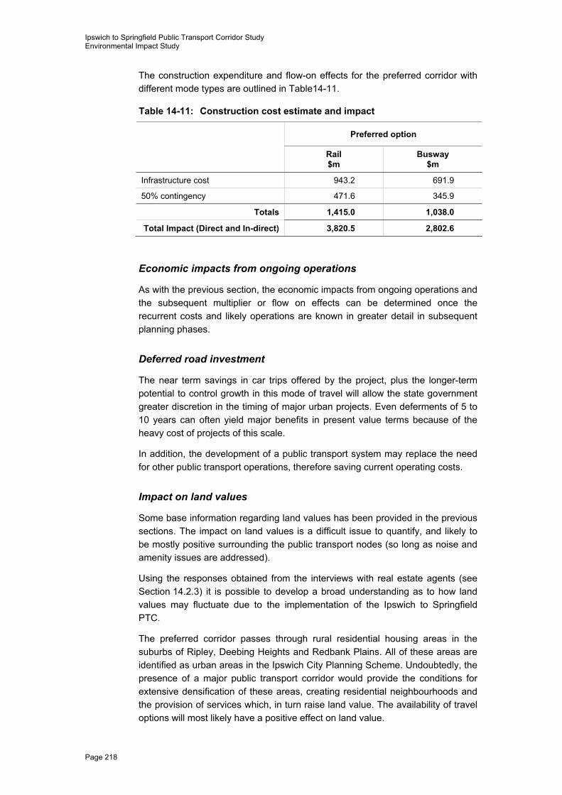
The construction expenditure and flow-on effects for the preferred corridor with different mode types are outlined in Table14-11.
Table 14-11: Construction cost estimate and impact
Preferred option
Rail $m
Busway $m
Infrastructure cost 943.2 691.9
50% contingency 471.6 345.9
Totals 1,415.0 1,038.0
Total Impact (Direct and In-direct) 3,820.5 2,802.6
Economic impacts from ongoing operations
As with the previous section, the economic impacts from ongoing operations and the subsequent multiplier or flow on effects can be determined once the recurrent costs and likely operations are known in greater detail in subsequent planning phases.
Deferred road investment
The near term savings in car trips offered by the project, plus the longer-term potential to control growth in this mode of travel will allow the state government greater discretion in the timing of major urban projects. Even deferments of 5 to 10 years can often yield major benefits in present value terms because of the heavy cost of projects of this scale.
In addition, the development of a public transport system may replace the need for other public transport operations, therefore saving current operating costs.
Impact on land values
Some base information regarding land values has been provided in the previous sections. The impact on land values is a difficult issue to quantify, and likely to be mostly positive surrounding the public transport nodes (so long as noise and amenity issues are addressed).
Using the responses obtained from the interviews with real estate agents (see Section 14.2.3) it is possible to develop a broad understanding as to how land values may fluctuate due to the implementation of the Ipswich to Springfield PTC.
The preferred corridor passes through rural residential housing areas in the suburbs of Ripley, Deebing Heights and Redbank Plains. All of these areas are identified as urban areas in the Ipswich City Planning Scheme. Undoubtedly, the presence of a major public transport corridor would provide the conditions for extensive densification of these areas, creating residential neighbourhoods and the provision of services which, in turn raise land value. The availability of travel options will most likely have a positive effect on land value.

Ipswich to Springfield Public Transport Corridor Study Environmental Impact Study
PB 2134204A-RPT020-D:br Page 219
Under SEQRP and the Ipswich City Planning Scheme, the Springfield Town Centre is designated a regional activity centre. As such it is expected that this area will experience significant growth through an increase in connectivity to regional and local business services. Subsequently, the two factors most likely to influence land value include the high level of growth occurring throughout the Western Corridor and the focus of the Ipswich City Planning Scheme on the commercial development of the Springfield Town Centre.
Reduction or at the very least prevention of negative environmental conditions such as congestion and associated traffic noise and pollution as a direct result of a transport corridor will have a positive effect on property value. Areas most significantly affected include those surrounding major congestion-prone roads, primarily Redbank Plains Road, the Cunningham Highway and the Ipswich Motorway.
Again, increased access to public transport nodes will have an additional positive effect, although this is likely to be minimal.
Intangible economic costs and benefits
More comfortable public transport travel
The quantified benefits for existing public transport users in the vicinity of the preferred corridor is likely to only relate to travel time savings. However, these users may also have a travelling experience of significantly higher quality in terms of noise, vibration, odour, and vehicle fit out. If fares remain comparable to those currently applied in other public transport options, improvements in ride comfort will deliver to passengers an expansion in consumer surplus. It would be difficult to quantify the outcome of this benefit without undertaking ‘willingness to pay’ surveys with existing public transport users.
Reduced social exclusion costs
The benefits associated with giving unemployed persons greater geographic access to employment opportunities has been quantified above. However, it is arguable that improving employment access will help reduce the correction costs associated with social exclusion. Such costs might include inflated home and car insurance premiums in areas of high unemployment and the costs associated with correcting antisocial behaviour such as theft, drug use, violence and the like.
Although it would be difficult to attribute an exact portion of the benefits of reduced social exclusion associated to the upgraded transport network, indicators that might be applicable at a local level include the following:
� unemployment rate
� proportion of low income earners
� proportion of transfer payments
� ABS index of social disadvantage
� child protection notifications
Ipswich to Springfield Public Transport Corridor Study Environmental Impact Study
Page 220
� domestic violence assessments
� house theft
� assaults.
Health impacts of reduced growth in air pollution
More than two dozen community health studies since 1987 have linked particulate pollution to reductions in lung function, increased hospital and emergency room admissions, and premature deaths. Recently, two major epidemiological studies (by the American Cancer Society and Harvard University) were published that showed that people living in more polluted cities had an increased risk of premature death compared to those in cleaner air cities (www.igc.apc.org)
Combustion of fossil fuels is the principal source of fine particle emissions, including the burning of coal, oil, diesel fuel, gasoline, and wood in transportation, power generation, and space heating. Thus, other things being equal, the reduction in future growth of car travel due to the provision of public transport along the preferred corridor is expected to have significant health benefits.
However, given the high rate of population growth predicted for the area, any health benefits attributed to the Ipswich to Springfield PTC are likely to be offset by an increase in use of private vehicles brought about by population growth.
Induced travel
Induced travel can come in two forms: firstly, the travel that is facilitated by the public transport that would otherwise not have occurred, and secondly, the road travel facilitated by the numbers of public transport users switching from cars.
It is arguable that most induced rail travel would benefit persons that do not have access to private transport, be that as a result of physical, social or economic disadvantage. The expansion and upgrading of the public transport network is likely to reduce the perceived cost of transport for a number of disadvantaged persons, usually through the removal of accessibility constraints.
Induced travel is valued highly by disadvantaged persons.
As noted, the reserve of road capacity created by the mode shift associated with the new public transport will ultimately induce additional car travel compared to the base case. This may constitute a net benefit or cost to society depending on the emissions and congestion externalities associated with the induced travel.
14.5 Conclusion and recommendations The Ipswich community currently views itself as a place for families and a city that is developing as a major centre for development, education, employment and business hub in south-east Queensland. With the city moving forward and expecting a dramatic increase in population a public transport corridor is required to be protected for future transport infrastructure.
Ipswich to Springfield Public Transport Corridor Study Environmental Impact Study
PB 2134204A-RPT020-D:br Page 221
The socio-economic impact assessment was commissioned to review all known likely impacts resulting from the preservation of a corridor, eventual construction, as well as maintenance and operation of a public transport system. The assessment also provides mitigation and management strategies to ensure that any potential impacts are minimised.
It is recommended that steps are taken by the government to ensure possible impacts are addressed in the following ways:
� contact with directly affected property owners should be maintained until the construction of the Ipswich to Springfield PTC takes place
� hardships experienced by particular property owners should be addressed as early as possible
� ongoing consultation should take place at during all stages of the preservation of the preferred corridor, eventual construction and maintenance
� noise, air quality, visual and economic mitigation measures should be implemented as far in advance of construction as possible
� notice provided to all nearby residents of happenings that may occur in relation to the preferred corridor, including construction maintenance
� establish effective communication strategies for ensuring study contact details are readily available to community members.
