is' nari - yorkshire dales national park authoritypacsplanning.yorkshiredales.org.uk/horton in...
TRANSCRIPT

DATED is' N a r i 201 6
(1) YORKSHIRE DALES NATIONAL PARK AUTHORITY
(2) HANSON QUARRY PRODUCTS EUROPE LIMITED
. . . . . . . . - . . . .
AGREEMENT
under Section 106 and Section 106A of the Town and Country ~ lann ' i in~ Act 1990 relating to
Horton Quarry HorYon-in-Ribblesdale
Section 106 Agreement - HAN228.284~4592612~l~vlO.docx
AN AGREEMENT made on f i f ~ b 4 ~ a r d 2016
I. YORKSHIRE DALES NATIONAL PARK AUTHORITY of Yoredale, Bainbridge, Leyburn, North Yorkshire, DL8 3EL ("the Authority"); and
2. HANSON QUARRY PRODUCTS EUROPE LIMITED (Company Number 00300002) whose registered office is at Hanson House 14 Castle Hill Maidenhead SL6 4JJ ("the Owner");
1. RECITALS
1 .I The Authority is the Minerals Planning Authority for the purposes of the Act for the area within which the Site is located.
1.2 The Owner is the freehold owner of the Site.
1.3 The Owner has submitted the Application to the Authority and the Authority has resolved to grant Planning permission subject (inter alia) to the completion of this Agreement.
1.4 - The parties have agreed to enter into this Agreement with the intention that the obligations contained in this Agreement may be enforced by the Authority against the Owner or any person or persons deriving title from them.
1.5 The Owner entered into the Original Undertaking which affects the Site and the parties have agreed that this Agreement should replace the Original Undertaking.
DEFINITIONS AND INTERPRETATION
In this Agreement unless the context requires otherwise the following words and expressions have the respective meanings as set out opposite to them:-
"Act"
"Application"
"Annual Management Meeting"
The Town and Country Planning Act 1990 (as amended) an application received on 26th November 201 5 carrying the reference C1441116U for the carrying out of the Development
a management meeting comprising the representatives of the Owner and the Authority and such other persons with appropriate knowledge or experience invited from time to time to join the management meeting with the agreement
I p p p p p p p p - - - - - - - - - - , Section 106 Agreement - HAN228.284~4592612~l~vlO.docx

"Beecroft Hall Borehole"
L'Commencement Date"
"Development"
of the parties.
The 5" diameter abstraction borehole at Beecroft Hall situate at NGR SD 800 727
the date of this Agreement
variation of Condition 7 of the determination of conditions reference Cl441116G
"Further Habitat Management Plans" the management plans to cover the
Management Period after the expiry of the lnterim Habitat Management Plan submitted and approved pursuant to paragraph 3 of Schedule 2 of this Agreement which management plans shall include the matters set out in Schedule 1 each management plan to cover a period of 10 years from the date of its approval unless otherwise agreed between the Owner and the Authority (acting reasonably and without delay)
"Habitat Management Plans"
"lngleborough Complex SAC"
the lnterim Habitat Management Plan and the approved Further Habitat Management Plans
the area of land known as the lngleborough Complex designated as a Special Area of Conservation with effect from 1 April 2005 as confirmed by notice dated 12 July 2005
"Interim Habitat Management Plan" the Habitat Management Plan relating to the Site attached to this Agreement dated February 201 6
2 Section 106 Agreement - HAN228.284~4592612~l~vlO.docx
"Judicial Review Period" the date 13 weeks after the date on which Planning Permission is granted subject to no legal proceedings having been commenced by any person to challenge the validity of the Planning Permission or if legal proceedings are commenced the date seven days after the final determination of those legal proceedings in a form that leaves the Planning Permission in place
the period from 18'"ebruary 201 1 to 21 February 2042
"Management Period"
"Original Undertaking" a section 106 Undertaking dated 18 February 201 1 and made by the Owner relating to the Site
"Plan" the plan attached to this Agreement marked Plan I (Drawing reference H 1 1 6/44)
"Planning Permission" the planning permission which the Authority has resolved to grant in pursuance of the Application a draft of which is set out in Schedule 4
"the Site"
"1965 Permission"
the land known as Horton Quarry edged blue on the Plan
the planning permission for winning and working of minerals dated 3 May 1965, Reference YDlSE1491
"1968 Permission" the planning permission for winning and working of minerals and access dated 1 October 1968 Reference YDlSE1716
2.2 The masculine feminine and neuter genders include each of the other genders and the singular includes the plural and vice versa
2.3 A reference to an Act of Parliament refers to the Act as it applies at the date of this Agreement
2.4 A reference to a clause or schedule is a reference to a clause or schedule contained in this Agreement
3
Section 106 Agreement - HAN228.284-4592612-1-vl O.docx

Legend
Extraction consent Ref YD/SE491. Dated 03/05/1965
Extraction consent Ref YD/S6716 Dated Ol/lD/I968
Peimilted mserves wifhin SAC area to remain unworked
Plan 1 Reproduced by permission of Ordnanca Survey on behalf of HMSO. 8 Crown copyright and 1 datsbaae a h 1 2009. Yl rights reserved. Ordnanm Survey IIcence number 0100032140. I
Site I Horton Quarrv I Title .Unilateral Undertaking S106
Town and Country Planning Act 1990
Scale 1 :5000 Drawn by AG Drawing No. Revision
Date nne 3n4n Iaeo*@ HI16144
References to any party in this Agreement shall include the successors in title of that party and in the case of the Authority includes any successor minerals planning authority exercising planning powers'under the Act.
OPERATIVE PROVISIONS
This Agreement is made pursuant to Section 106 and Section 106A of the Act and the obligations contained in this Agreement are planning obligations for the purposes of that section in so far as they fall within the terms of sub-section 106(1).
In so far as any of the covenants contained in this Agreement are not planning obligations within the meaning of the Act they are entered into pursuant to the powers contained in Section 1 I 1 of the Local Government Act 1972 and all other enabling powers.
The Authority is the Minerals Planning Authority by which the planning obligations contained in this Agreement are enforceable.
The covenants contained in this Agreement shall only come into effect on the Commencement Date unless otherwise specifically indicated in this Agreement.
No person shall be liable for any breach of the covenants restrictions or obligations contained in this Agreement unless he holds an interest in the part of the Site in respect of which such breach occurs or held such an interest at the date of the breach.
Nothing in this Agreement shall prohibit the right to develop any part of the Site in accordance with a planning permission (other than the Planning Permission) granted (whether or not on appeal) after the date of this Agreement SAVE THAT if the Authority agrees pursuant to an application under Section 73 of the Act to any variation or release of any condition contained in the Planning Permission or if any such condition is varied or released following an appeal under Section 78 of the 1990 Act the covenants or provisions of this Agreement shall be deemed to bind the varied permission and to apply in equal terms to the new planning permission and references in this Agreement to the Application the Planning Permission and the Development shall be construed accordingly
This Agreement shall cease to have effect if:-
3.7.1 the Planning Permission shall be quashed revoked or otherwise withdrawn or modified so as to render this Agreement or any part of it irrelevant impractical or unviable (save for any minor modifications to the Development as shall be agreed from time to time by the Authority and the Owner); or
3.7.2 the Planning Permission shall expire
The Owner covenants with the Authority to observe and perform the covenants set out in Schedule 2.
The Authority covenants with the Owner to observe and perform the covenants set out in Schedule 3.
4 Section 106 Agreement - HAN228.284~4592612~l~vlO.docx
3.1 0 The Owner shall bear the costs of the Authority incurred in the preparation and completion of this Agreement in the sum of f 500 Plus VAT.
3.1 I This Agreement shall be registered as a local land charge.
3.12 Nothing in this Agreement shall be or shall be construed to be a fetter or restriction on the proper exercise at any time by the Authority of any of its statutory powers functions or discretions in relation to the Site or otherwise.
3.13 The parties to this Agreement do not intend that any of its terms shall be enforceable by virtue of the Contract (Rights of Third Parties) Act 1999 by any person not a party to it or not a successor in the title to such a party.
4. RELEASE OF ORIGINAL UNDERTAKING
4.1 From the expiration of the Judicial Review Period, the Owner and the Authority agree that the Original Undertaking will be released to the extent that there remain any obligations outstanding and the Original Undertaking will not be capable of being enforced by the Authority after the expiration of the Judicial Review Period.
5 Section 106 Agreement - HAN228.284~4592612~l~vlO.docx

SCHEDULE I
Contents of Habitat Management Plans
1. Introduction
2. Description of Important features Within and Adjacent to Habitat Management Plan
3. Description of the Land within the Habitat Management Plan
4. Proposed ManagementIEstablishment of Habitats
5. Issues to address in Habitat Management Plan
6. Monitoring and Reporting
7. Action Plan
6
Section 106 Agreement - HAN228.284~4592612~l~vlO.docx

SCHEDULE 2
Owner's Obligations
1. Partial relinquishment of planning permissions
1.1 The Owner shall not win or work minerals pursuant to the 1965 Permission within the area of the lngleborough Complex SAC shown coloured pink hatched black on the Plan and the 1965 Permission shall be treated by the Owner as revoked in relation to the area of the lngleborough Complex SAC shown coloured pink hatched black on the Plan and the Owner further undertakes not to claim compensation from the Authority pursuant to this paragraph 1 .I
1.2 The Owner shall not win or work minerals pursuant to the 1968 Permission within the area of the lngleborough Complex SAC shown coloured green hatched black on the Plan and the 1968 Permission shall be treated by the Owner as revoked in relation to the part of the lngleborough Complex SAC shown coloured green hatched black on the Plan and the Owner further agrees with the Authority not to claim compensation from the Authority pursuant to this paragraph 1.2
1.3 The Owner shall not construct any access routes or carry out any operations pursuant to the 1968 Permission within the area of the lngleborough Complex SAC shown coloured yellow on the Plan and the 1968 Permission shall be treated by the Owner as revoked in relation to the part of the lngleborough Complex SAC shown coloured yellow on the Plan and the Owner further undertakes not to claim compensation from the Authority pursuant to this paragraph 1.3.
2. Annual Report & Annual Management Meeting
2.1 The Owner shall organise the Annual Management Meetings which shall be held at the Owner's Horton Quarry offices (or as otherwise agreed by the Owners and the Authority). The meetings shall be held annually (unless it is agreed that an additional meeting is required) in September or October following the submission of an annual report by the Owner to the Authority.
2.2 The monitoring field work for the report referred to in paragraph 2.1 shall be undertaken in JuneIJuly and a single detailed annual report shall be submitted by the Owner to the Authority no later than September each year.
2.3 The Owner shall consult with the Authority on the preparation implementation and monitoring of the Further Habitat Management Plans at the Annual Management Meeting.
3. Submission and Approval of the Habitat Management Plans
7 Section 106 Agreement - HAN228.284~4592612~l~vlO.docx
3.1 The Owner undertakes to submit to the Authority for approval Further Habitat Management
Plans before the expiry of the period of 9 years 6 months of the current Habitat Management Plan
3.2 The Owner undertakes to implement the Habitat Management Plans for the Management Period from the date of their approval or (where applicable) from the date of expiry of the current Habitat Management Plan if later.
4. Hours of Operation for HGVs
4.1 No heavy goods vehicles shall enter or leave the Site except between the following times:-
06.30 to 17.00 hours Monday to Friday
4.2 No heavy goods vehicles shall enter or leave the Site on Saturdays, Sundays or StatutoryIPublic Bank Holidays.
5. Beecroft Hall Borehole
In the event that the Owner's activities on the Site adversely affect the Beecroft Hall Borehole so that it can no longer be utilised as a water supply for drinking water for livestock, the Owner will provide an equivalent alternative water supply for such purposes and for such period that the Beecroft Hall Borehole cannot be utilised in this way.
8 Section 106 Agreement - HAN228.284~4592612~l~vlO.docx
SCHEDULE 3
Authority's Obligations
I. Authority's Obligations
1.1 To act reasonably and properly and diligently in exercising its discretion and discharging its functions under this Agreement and in particular where any notice consent approval authorisation agreement or other similar affirmation is required under the terms of the Agreement not unreasonably to withhold delay or refuse such notice consent approval authorisation agreement or similar affirmation.
1.2 To issue the Planning Permission within ten working days of the date of this Agreement.
I .3 Where under the terms of this Agreement the Agreement shall expire terminate or cease to have effect to use all reasonable endeavours to vacate or cancel the entry made in the Local Land Charges Register in relation to this Agreement or otherwise to record the fact that it has expired or is no longer in force.
9 Section 106 Agreement - HAN228.284-4592612-1-vl O.docx

SCHEDULE 4
Planning Permission
10 Section 106 Agreement - HAN228.284~4592612~l~vlO.docx
I TOWN AND COUNTRY PLANNING ACT 1990 YORKSHIRE DALES NATIONAL PARK AUTHORITY
(Local Planning Authority)
I NOTICE OF DECISION OF PLANNING AUTHORITY ON APPLICATION FOR:
I PERMISSION TO CARRY OUT DEVELOPMENT
I To: Mr BJ Ayres
Hanson UK Decision No: C/44/116U
I
The above named Authority being the Local Planning Aut for the purposes of your application received on 26/11/2015 for variationkf Condition 7 of planning permission C144I116G to retain the HGV movement,t<mes as 0630-1700 hours Monday to Friday, and to cease HGV movements on Satyday mornings Y Horton Quarry, Horton-in-Ribblesdale, SD795721 have considered the said application and have GRANTED permission for the proposal subjedt to the following Conditions:
1. The winning and working of minerals and depos~tihg of cease not later than 21 February 2042. Within and working of minerals at the site r by 21 4' buildings, plant and machinery at hebite the site shall have been completed in acb~dance with Drawing No HA-104 revision A dated April 2009, Restoration Plan and Draw~ns No HA305 revision A dated April 2009 Restoration Cross
Sections A - C.
2. All quarrying ccordance with the details shown
. HA-1 06 dateckpril2009; 10 Year Interim Development Plan . HA-103 Revis ioM dated Apri Permitted Quarry Development Proposals
QRevision ~ v a t e d ~estorhtion Plan Cross Sections A - C
3. extraction area shall take
SEl575 282 metres Y DISEl49 1 31 2 metres YDISEl716 296 metres
Restriction, no quarrying nor any other form of excavation shall take place below the base of the Carboniferous Limestone.
Date: . . . . . . . . . . . . . . . . . . . . . . . . . . . . . . . . . . . . . . . . . . . . . . . . . . . . . . . . . . . . . . . . . . . . . . . . . . . . . . . . . . . . . . . . . . . . . . . .
Designation HEAD OF DEVELOPMENT MANAGEMENT
FOR NOTES AND RIGHTS OF APPEAL SEE OVERLEAF
Page 1 of 6
- - -
Continuation Sheet 1 C/44/116U 4. No quarry waste or overburden arising from the quarry operations shall be placed or deposited
except as part of an approved restoration or landscaping scheme within the quarry or within the area of the Active Quarry Tip shown on drawing number HA-1 06 dated April 2009, 10 Year Interim Development Plan.
5. Full details of the proposed working, restoration, landscaping and planting to be undertaken during the next twelve month period shall be submitted to the National Park Authority annually in September each year (or at such other time as may be agreed in writing by the National Park Authority) for their written approval. The scheme shall include full details of the placement of quarry waste, ground preparation, fencing, walling, planting, seeding and maintenance and management of planting and restored areas. Thereafter, landscaping, planting, maintenance and management shall take place with the approved details.
6. Except in an emergency all road vehicles visiting ~ o r t ~ & a r t - y shall enter and leave the site via the existing main quarry access on to Cragg Hill Road (Site ~ntran>e on drawing number HA- 102 Revision A dated April 2009, Existing Site Ca/f@uration). This chdition shall not operate to prevent the occasional use of the access via Beecroft Hall by road vehides carrying large items of plant, machinery or equipment which are t 61arge to enter the quarry vibthe main quarry access. ? \
\ \A 7. No heavy goods vehicles shall enter or leave Horto \Quarry e)c&pt between the ollowing times:
06.30 to 17.00 hours Monday to 2 No heavy goods vehicles shall enter or Sundays or StatutorylPublic Bank Holidays.
8. Precautions, includi shall be taken and maintained to ens& that condition, such that no dirt and{b;rnud are from the quarry.
repair and maintenance, shall be
or StatutoryIPublic Bank
B \ 10. All road vehic s transporting material shall be securely covered or sheeted before leaving Horton Quarry.
Page 2 of 6

Continuation Sheet 2 C/44/116U 11. Ground vibration as a result of blasting shall not exceed a peak particle velocity of 6mms-I in
95% of all blasts measured over any period of six months, and no individual blast shall exceed a peak particle velocity of 8mms-I as measured at vibration sensitive residential buildings. The
measurement to be the maximum of three mutually perpendicular directions, taken at the ground surface.
The company shall monitor vibration levels and air over pressure resulting from each blast at locations agreed in writing with the National Park Authority and shall forward details of the monitoring to the National Park Authority within seven days of carrying out the monitoring.
12. Except in an emergency, no blasting shall be carried out except tween the following times: P3
09.00 to 17.00 hrs Monday to Friday / No blasting shall be carried out on Saturdays, SundayAStatutbaPubIic/Bank Holidays.
'ih 13. Noise levels arising from operations carried out a t h t o n Quarry shal ot exceed the following noise levels in dBLaeq (one hour) at the specif.& monitoring locations, h e n measured at a height of 1.5 metres above the ground and i A ree field conditions:
Monitoring Location National
of the results to the National park$uthority within 28 days of receiving written notification. '
14. Where vehicle operating within the such other reversing
shall be ope '? ated and maintained, including the fitting of minimise noise emissions.
and Country Planning (General Permitted other order revoking and re-enacting that Order) no
retained on site for longer than 28 days) or buildings land in connection with the
permission.
to avoid sideways or upwards glare. All lighting shall be switched off when the site is not in operation.
18. No rock breaking equipment shall be operated at Horton Quarry except in accordance with the details submitted by Hanson UK dated 13 July 201 1 and approved by the National Park Authority on 4 August 201 1.
Page 3 of 6

Continuation Sheet 3 Cl441116U Precautions including the use of water sprays on quarry roads and haul routes and on mineral stockpiles, shall be taken to control dust generation at Horton Quarry. Spraying shall be undertaken as frequently as necessary to control and minimise the generation of dust to the satisfaction of the National Park Authority.
The whole of the quarry access road from the public highway to the position of the existing weighbridge shall be swept and cleaned as frequently as necessary to ensure that no dirt and/or mud are deposited on the public highway by vehicles travelling from Horton Quarry and to
prevent the generation of dust to the satisfaction of the National Park Authority.
All stone walls and fencing within the quarry or forming a boundary of Horton Quarry shall be repaired as necessary and maintained in good condition through&t,the life of the development.
processing or any other purpose. No rock or aggregates shall be imported into any part for stockpiling,
No materials other than uncontaminated excavated'hatural materials\$inating at Horton Quarry or lime waste already present on the site shall gdeposited at the
restoration of the quarry. P Water level monitoring shall be undertaken i i accordance with the updated ~ a e h o l e Monitoring Scheme submitted by Hanson UK dated 10 March 2015, draw'ng No H I 16/32 rebision D dated March 2015 and drawing No HI16140 revision D date8Yarch!!Of5. Water level mb itoring shall be undertaken monthly in each bpnhole in accordance h i t6 this scheme and the re $ ults shall be reported annually in March each yeh ika written report to the National Park Authority.
No soil stripping or working shall take and the northern part of YDISEl716 that
detailed scheme other mitigationpasures has
scheme. \ Authority. Ther after all
No soil stri ping or w o h shall takqlace in the cbrrently unworked park of SE 575 and the south&f YD/SEli'l%th'at l ~ e ou t sd the lnglehrough site of Special Scientific Interest ( ~ s I ) until a debled scheme for the t rans~oh t i~n of hrves, the stripping, handling and
hacement of soils anhqther m~tigation measures has been submitted to and approved in writing by the National Park Authority. ~he>e?fter all development shall be undertaken in accordance w~th t y r o v e d scheme\ \ No soil str ping or working s II take plac in any of the currently unworked parts of SE 575 and Y D I S E ~ ~ ~ until a systematic walkover survey at 10m spaced transects has been
of archaeological interest and a detailed scheme, including measures for recording has been submitted to and approved in writing by the
all development shall be undertaken in accordance with the approved scheme.
There shall be no development or construction of any access track or route (other than the existing access to the upper quarry face shown on Drawing No HA-102 Revision A dated April 2009, Existing Site Configuration) in the areas of YD/SE/716 that are outside the permitted extraction limit.
Page 4 of 6

Continuation Sheet 4 C/44/116U Reason(s): 1. To ensure the restoration of the site to a satisfactory standard with the minimum of delay at
the end of the working period in accordance with saved policy GP4 (landscape enhancement schemes) in the Yorkshire Dales Local Plan.
2. To ensure the development is carried out in accordance with the application details in accordance with saved policy GP4 (landscape enhancement schemes) and saved policy EPI (protecting the environment) in the Yorkshire Dales Local Plan.
3. To prevent quarrying below the depths for which impacts have been assessed and to ensure the satisfactory restoration of the site in accordance with save policy EPI (protecting the environment) and saved policy GP4 (landscape enhancemekkkhemes) in the Yorkshire Dales Local Plan. /
4. To avoid pollution and to ensure the satisfactory restohon ofbthe site in accordance with saved policy EPI (protecting the environment) anddaved enhancement schemes) in the Yorkshire
5.
Plan.
To ensure the satisfactory progressive with saved policy GP4 (landscape enhan&ment schemes) in the Yorkshhe Dales Local
\ \ \
6, 8, 10. In the interests of highway safety and amenity i h c o r d a &ith saved policy EPI II (protecting the environment) i ~ R ~ Y o r k s h i r e ~ a l e s b . ~ Plan. \ 7, 9, 12. To limit operations to
amenity in accordance with saved in the Yorkshire Dales Local Plan.
I I I To saved policy EPI
18. 14, 15, (protecting
16. To reserve the rig controlbf the ~at iona l Park Authority to'minimise visual intrusion and disturbance in with saved policy EPI (protecting the environment) in the Yorkshire Dales
policy EPI (protecting the environment) 17.
19, 20.' To minimise the genehtion of to avoid dirt on the public highway in accordance with she$ policy EPI (prothqting in the Yorkshire Dales Local Plan.
21. In the \t in erests of public sa \ ety and amenity \ in accordance with saved policy EPI (protecting the en~ i r oh~en t ) and p o l l c y ' ~ ~ 4 (landscape enhancement schemes) in the Yorkshire Dales Local Plan.
22. of the National Park Authority to avoid additional road policy EPI (protecting the environment) in the Yorkshire
Dales Local Plan.
23. In the interests of amenity, to avoid pollution and to ensure satisfactory restoration of the site in accordance with saved policy EPI (protecting the environment) in the Yorkshire Dales Local Plan.
Page 5 of 6
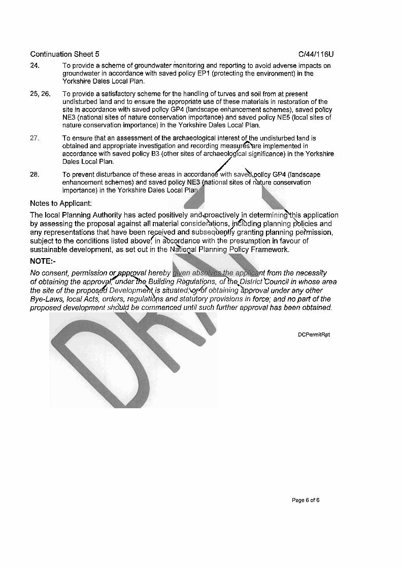
Continuation Sheet 5 C/44/116U 24. To provide a scheme of groundwater monitoring and reporting to avoid adverse impacts on
groundwater in accordance with saved policy EPI (protecting the environment) in the Yorkshire Dales Local Plan.
25, 26. To provide a satisfactory scheme for the handling of turves and soil from at present undisturbed land and to ensure the appropriate use of these materials in restoration of the site in accordance with saved policy GP4 (landscape enhancement schemes), saved policy NE3 (national sites of nature conservation importance) and saved policy NE5 (local sites of nature conservation importance) in the Yorkshire Dales Local Plan.
To ensure that an assessment of the archaeological interest of the undisturbed land is obtained and appropriate investigation and recording measur&re implemented in accordance with saved policy 83 (other sites of archaeolodcal significance) in the Yorkshire Dales Local Plan. /
28. To prevent disturbance of these areas in accordanokwith sa~&,~o l i c~ GP4 (landscape enhancement schemes) and saved national sites of n%ture conservation importance) in the Yorkshire Dales Local Pla
Notes to Applicant: The local Planning Authority has acted positively and,proactively in determininhhis application by assessing the proposal against all material considehtions, i n h d i n g planning h l i c ies and any representations that have been received and subseqhegtl$ granting planning pe?mission, subject to the conditions listed above/ln hcordance with the presumption in favour of sustainable development, as set out in the ~&m@al Planning Policy Framework. NOTE:- No consent, permission or pp oval hereby nt from the necessity B 'm of obtaining the approva , under e Building Regulations. of>heqstrict ct'Counci1 in whose area the site of the proposkd ~eve lo~rneh t is situated;iordf obtaining approval under any other Bye-Laws, local Acts, orders, regulatibns and statutory provisions in force; and no part of the proposed development shoblg be commenced until such further approval has been obtained.
DCPermitRpt
Page 6 of 6
Executed as a Deed on the date specified at the commencement of this Agreement
THE COMMON SEAL of YORKSHIRE DALES NATIONAL PARK AUTHORITY was affixed in the presence of:-
EXECUTED (but not delivered until the date hereof) As a DEED by HANSON QUARRY PRODUCTS EUROPE LIMITED Acting by two Directors or a Director and Secretary
11 Section 106 Agreement - HAN228.284~4592612~l~vlO.docx

Horton in Ribblesdale Quarry
Horton in Ribblesdale Quarry Interim Habitat Management Plan
CONTENTS
Section Page No
.............................................................................................................. 1 . INTRODUCTION 1
1 . 1. Setting .............................................................................................................................. 1 ....................................................................................................................... 1.2. Site History 1
2 . DESCRIPTION OF IMPORTANT FEATURES WITHIN AND ADJACENT TO IHMP ............................................................................................................................. 3
2.1. lngleborough Special Area for Conservation (SAC) ....................................................... 3 ................................................................ 2.2. lngleborough National Nature Reserve (NNR) 3
2.3. lngleborough Site of Special Scientific Interest (SSSI) .................................................... 3 ............................................................................................. 2.4. Limestone Pavement Order 4
3 . DESCRIPTION OF THE LAND WITHIN THE IHMP ....................................................... 4
........................................................................................... 3.1. Parcel 1 (Photographs 1 & 2) 4
........................................................................................... 3.2. Parcel 2 (Photographs 3 & 4) 4 ................................................................................................... 3.3. Parcel 3 (Photograph 5) 5
3.4. Parcel 4 (Photographs 6 & 7) ........................................................................................... 6 3.5. Parcel 5 (Photographs 8 & 9) ........................................................................................... 6 3.6. Parcel6 ............................................................................................................................ 6 3.7. Parcel 7 (Photographs 10 & 11) ....................................................................................... 6 3.8. Parcel 8 (Photographs 12 - 14) ........................................................................................ 6
4 . PROPOSED MANAGEMENTIESTABLISHMENT OF HABITATS ................................ 7
Parcel 1 ........................................................................................................................... 8 Parcel 2 ............................................................................................................................ 8 Parcel 3 ............................................................................................................................ 9 Parcel 4 ............................................................................................................................ 9 Parcel 5 ............................................................................................................................ 9 Parcel 6 .......................................................................................................................... 10 Parcel 7 .......................................................................................................................... 10 Parcel 8 .......................................................................................................................... 10
....................................... 5 . ANNUAL REPORT & ANNUAL MANAGEMENT MEETING 12
................................... 6 . ISSUES TO ADDRESS IN HABITAT MANAGEMENT PLANS 12
................................................................................. 7 . MONITORING AND REPORTING 13
7.1. Monitoring ....................................................................................................................... 13 ........................................................................................................................ 7.2. Reporting 13
............................................................................................................... 8 . ACTION PLAN 14
Hanson Aggregates\49343429 Hanson 201 I\DBRP0004PRB/PRB Page i February 2016 Final

Horton in Ribblesdale Quarry Interim Habitat Management Plan
CONTENTS
Section Page No
9. COPYRIGHT .................................................................................................................. 15
................................................................................................................ 10. LIMITATIONS 15
TABLE 1 -SCHEDULE OF TARGETS AND MANAGEMENT PRESCRIPTIONS
FIGURE 1 - LAND PARCELS AND STATUTORY DESIGNATIONS
FIGURE 2 - PHASE 1 VEGETATION AND HABITATS
FIGURE 3 - PLANTATION WOODLANDS AND AREAS SURVEYED FOR TREE PLANTING
PHOTOGRAPHS - 1 - 14
Hanscm Aggregates\49343429 Hanscm 201 1\DBRP0004/PRBPRB Februaly 2016
Page ii Final
Horton in Ribblesdale Quarry lnterim Habitat Management Plan
1. INTRODUCTION
A Section 106 Undertaking dated 18Ih February 2011 made by Hanson required an lnterim Habitat Management Plan (IHMP) covering all the land within the blue line shown in Figure 1 to be prepared. The IHMP would cover a ten year period commencing in 201 1 until 2021 and this plan was approved by YDNPA on 03'~ December 2013.
Following the submission of a planning application to vary the working hours at the site the existing restrictions set out in the S106 Undertaking are being varied to incorporate the new Hours of Operation for HGVs from the site.
It has also been agreed to take the opportunity to amend other sections of the Undertaking. As such a new S106 planning obligation by agreement has been completed.
This lnterim Habitat Management Plan dated February 2016 replaces the existing lnterim Habitat Management Plan.
As well as the submission every 10 years of a new Habitat Management Plan the mechanism for review of the document will be the submission of annual report together with an annual management meeting with YDNPA and other interested parties (as necessary) rather than a rigid system of a series of management committee meetings.
The lnterim Habitat Management Plan divides the land into eight parcels for ease of description (Parcels 1 - 8, Figure 1).
Setting
Horton quarry is located within the western part of the Yorkshire Dales National Park, approximately 0.5 kilometres (km) west of the village of Horton in Ribblesdale, North Yorkshire. Access to the site is from Cragg Hill road. The quarry produces high quality' limestone aggregates for construction, manufacturing and agricultural industries. Hanson acquired the operation from the previous operators Tarmac Quarry Products Limited in September 2000.
1.2. Site History
Horton quarry has been worked for over 100 years but the 1'' permission was an lnterim development order (IDO) dating to 1948, which was updated in accordance with the Planning and Compensation Act 1990. The ID0 permission was to be subject to a periodic review in November 2011 but has been postponed with the agreement of the National Park Authority until February 2026.
A Section 106 agreement imposing an output restriction on material leaving the site by road through Horton village was entered into in October 1996 and a scheme of modern operating and restoration conditions was submitted for the site and approved on 15 November 1996 under Planning permission ref C/44/116CllDO. This permission covers a large proportion of the quarry including the site access and the processing plant area.
Hanson Aggregates\49343429 Hanson 201 l\DBRPO004/PRB/PRB February 2016
Final 1

Horton in Ribblesdale Quarry Interim Habitat Management Plan
The four planning permissions granted between 1952 and 1968 were subject to updating under the provisions of the Environment Act legalisation and the "mineral site" has recently been through a ROMP determination. The ID0 planning permission is excluded from the "mineral site" shown in red in Figure 1.
There are currently un-worked parts of the "mineral siten that overlap into areas designated as Site of Special Scientific Interest (SSSI) and Special Area of Conservation (SAC).
Hanson agreed as part of a unilateral undertaking agreement that accompanied the ROMP determination (ref C/44/116G) on 22nd February 2011 not to work the planned mineral in the area designated as a Special Area of Conservation (SAC).
Hanson also proposed not to enter and work the currently planned SSSI area and the adjacent area of grassland outside of the SSSI on the western boundary of the site without the prior discussion and agreement of appropriate mitigation proposals and long term management strategies with Natural England and other interested parties.
Hanson as part of this management plan will work with Natural England and other interested parties to ensure that the SAC and SSSI, and other land adjoining within the control/ownership of Hanson (edged blue on Figure 1) will be managed in accordance with agreed management objectives.
Horton Quarry has some 42 Mt of permitted limestone reserves remaining, which at the current output rate of 600ktpa is sufficient to last a further 70 years. In addition to the currently permitted reserves, further workable reserves of limestone and high quality gritstone have been proven to exist below the current depth restrictions.
The life of lngleton Quarry was extended to May 2020 in January 2016 (planning permission ref C/45/307L).
As part of Hanson's long term strategy for its Yorkshire Dales sites, gritstone working which currently takes place at lngleton quarry will be transferred to Horton once the reserves at lngleton Quarry are exhausted. At this point the Horton site will be worked for both Limestone and Gritstone.
No further quarrying is to take place at Hanson's dormant Old lngleton site; working rights were given up at this site and the quarry has now been restored using overburden and processing waste material from Ingleton.
This habitat management plan submission provides an opportunity to enhance the landscape and biodiversity of the site whilst planned extraction operations continue while also creating the conditions and basis of a successful site restoration scheme in the longer term.
Hanson Aggregates\49343429 Hanson 201 l\DBRP0004PRBPRB February 2016
Final 2

Horton in Ribblesdale Quarry Interim Habitat Management Plan
DESCRIPTION OF IMPORTANT FEATURES WITHIN AND ADJACENT TO IHMP
The quarry is situated within an area of high nature conservation and landscape value and international and nationally statutorily designated sites border the quarry to the north, west and south.
lngleborough Special Area for Conservation (SAC)
The lngleborough Complex SAC is a large site (approximately 5700ha) bordering the north, south and west of the quarry. Land parcels 4 and 5 are situated within the SAC and the permission to quarry Parcel 5 has been relinquished by Hanson Aggregates under the 201 1 ROMP. The planning permission allows access only into Parcel 4 and no extraction but under the Unilateral undertaking Agreement this has been revoked.
The primary features for which the SAC has been designated include:
Juniper (Juniperus communis) formations on heaths or calcareous grasslands
Alkaline Fens - Spring-fed flush fens of NVC type MI0 Carex dioica - Pinguicula vulgaris mire; often species-rich with rare or locally distributed species
Calcareous rocky slopes with chasmophytic vegetation - Crevice communities with a mix of northern and southern species
Limestone pavements -the most extensive series of pavements in the UK
Other primary features present but not a reason for designation include
Semi-natural dry grasslands and scrubland facies
Molinia meadows
Blanket bogs
Petrifying springs
Tilio - Acerion forests
lngleborough National Nature Reserve (NNR)
lngleborough NNR is approximately 1012ha and is designated under Section 9 of the National Parks and Access to the Countryside Act, 1949. The NNR includes the land to the north and west of the quarry and immediately south of Parcels 4 & 5.
lngleborough Site of Special Scientific Interest (SSSI)
lngleborough SSSl is a large site (approximately 5230ha) bordering the north south and west of the quarry and also includes Parcel 2 within the quarry that has permission to be
Hanson Aggregates\49343429 Hanson 201 I\DBRP0004PRBPRB Final February 2016 3

kgc0M Horton in Ribblesdale Quarry Interim Habitat Management Plan
quarried. Land Parcels 4 and 5 and a small part of the north west corner of Parcel 1 are also situated within the SSSI.
The site is designated both for its geological interest and associated diverse and distinctive botanical communities.
2.4. Limestone Pavement Order
In addition to being a qualifying feature for the SAC, the limestone pavement in the area around the quarry is the subject of a Limestone Pavement Order and this includes pavement within Parcel 4 (Figure 1).
DESCRIPTION OF THE LAND WITHIN THE IHMP
The habitats present within the eight parcels of land in the IHMP are shown in Figure I.
3.1. Parcel 1 (Photographs 1 & 2)
A small part of the north western end of this parcel is within lngleborough SSSI with the SAC bordering the north. The remainder however falls outside of any designation. The north and east boundaries are stone walls and the south west boundary is a fence with the working boundary the other side of the fence.
There are extensive areas of calcareous grassland dominated by blue moor-grass (Sesleria albicans) with abundant sheep's-fescue (Festuca ovina), quaking grass and glaucous sedge. Most of the limestone pavement has been disturbedlremoved in the past but the remnant surface is being colonised by calcareous grassland species from surrounding grassland. The eastern part is on an east facing slope and comprises disturbed pavement, sparsely vegetated with tree planting below and undisturbed calcareous grassland towards the stone wall boundary. There are a number of juniper bushes alongside the wall in this area. They range in condition from young healthy bushes to dead and moribund plants.
3.2. Parcel 2 (Photographs 3 & 4)
This comprises an approximately 100m wide strip of land along the north western side of the quarry, southwards to a stone-wall that separates it from Parcel 3 and an area of predominantly disturbed pavement along the northern boundary. The strip along the west is situated within lngleborough SSSI and bounded by lngleborough SAC and lngleborough NNR to the west.
The long strip along the western boundary comprises calcareous grassland dominated by blue moor-grass with quaking grass (Briza media) and sheep's fescue locally frequent. Glaucous sedge (Carex flacca) was abundant all over this area. Herbs present included abundant wild thyme (Thymus polytrichus), bird's-foot trefoil (Lotus comiculatus), limestone bedstraw (Galium stemen] and lady's bedstraw (Galium verum). Other herb species included early purple orchid (Orchis mascula), a lady's mantle species (Alchemilla vulgaris agg.), autumn gentian (Gentianella amarella), yarrow (Achilles
Hanson Aggregates\49343429 Hanson 201 I\DBRP0004/PRB/PRB February 2016
Final 4
Horton in Ribblesdale Quarry Interim Habitat Management Plan
millefolium), common dog-violet (Viola riviniana) and common ragwort (Senecio jacobaea).
Within the area are what appear to be small areas of limestone pavement with several localised outcrops where the soil was skeletal or non-existent. Plant species associated with these areas included common whitlow-grass (Erophila vema), lesser meadow-rue (Thalictrum minus), wild thyme, hart's-tong ue fern (Phyllitis scolopendrium), maidenhair spleenwort (Asplenium trichomanes), brittle bladder-fern (Cystopteris fragilis), carnation sedge (Carex panicea), herb-robert (Geranium roberfianum), blue moor-grass and sheep's-fescue. Bryophytes were also recorded.
Forming a mosaic with the calcareous grassland were several patches of heathland and acidic grassland. These areas were characterised by locally dominant patches of common bent (Agrostis capillaris) and patches of heat her (Calluna vulgaris). Other species present in these areas included heath-grass (Danthonia decumbens), green- ribbed sedge (Carex binenlis), tormentil (Potentilla erecta) and harebell (Campanula rotundifolia).
Parcel 3 (Photograph 5)
This is located immediately to the south of Parcel 2 below a stone wall and continues south to a fence that divides it from Parcel 4. There is also a fence along the eastern boundary to the current working area and a fence along the western boundary to lnglebrough SACISSSI.
Calcareous grassland is again dominant, with acidic flushes (some large). No pavement appears to be present, rather some localised rock outcrops.
Blue moor-grass was dominant, with abundant sheep's-fescue and quaking-grass. Glaucous sedge was also abundant and herbs included fairy flax (Linum catbarticum), bird's-foot trefoil, limestone bedstraw, lady's bedstraw, wild strawberry (Fragaria vesca), wild thyme, early purple orchid and common ragwort.
The small rock outcrops had abundant bryophytes, with a small amount of limestone bedstraw and moonwort (Botrychium lunaria).
The small areas of acidic grassland form an intricate mosaic with the calcareous grassland and were dominated by common bent, with tormentil locally abundant and velvet bent (Agrostis canina) occasionally recorded. Heather was only rarely recorded within this area.
The wet acidic flushes were concentrated along the western edge and were dominated by purple moor-grass (Molinia caenrlea) and heath-rush (Juncus squarrosus), with occasional clumps of bilberry (Vaccinium myrtillus) and cross-leaved heath (Erica tetralix). Common dog violet, tormentil, mat grass (Nardus stricta) and green-ribbed sedge were also recorded.
Hanson Aggregates\49343429 Hanson 201 I\DBRP0004/PRBIPRB February 2016
Final 5
Horton in Ribblesdale Quarry Interim Habitat Management Plan
3.4. Parcel 4 (Photographs 6 & 7)
Most of this parcel is within lngleborough SACISSSI and is bounded to the south by lngleborough NNR. Part also falls within the Limestone Pavement Order.
There are large areas of intact limestone pavement particularly on the rising ground to the west. Two large acidic flushes are present within the pavement at the western end.
The majority of the vegetation is dominated by blue moor-grass with abundant sheep's- fescue, quaking grass and glaucous sedge. Herbs included fairy flax and wild thyme. Small areas of acidic grassland have formed within this habitat, characterised by common bent, mat grass and bell heather (Erica cinerea).
The extensive areas of limestone pavement have rich flora associated with the grykes. These include several species of fern including hart's-tongue, maidenhair-spleenwort, hard shield fern (Polysfichum aculeatum), black spleenwort (Asplenium adianfum-nigrum) and lady fern (Afhyrium felix-femina). Other pavement species included wood sorrel (Oxalis acetosella), herb-robert and lesser celandine (Ranunculus ficaria).
3.5. Parcel 5 (Photographs 8 & 9)
Habitat similar to Parcel 4 but with only disturbed pavement but also in Parcel 5 there are juniper bushes (Juniperus communis) and a few planted European larch (Larix decidua) trees. The juniper bushes range widely from young healthy bushes to dead and moribund stands.
3.6. Parcel 6
Predominantly plantation woodland with bracken and small remnant areas of calcareous grassland above quarry faces.
3.7. Parcel 7 (Photographs 10 & 1 I )
Four sheep grazed pastures divided by stone walls. Overall the pastures are generally poor semi-improved but there are areas of better quality grassland, particularly on the slopes of the dry valley. The largest field is bounded to the south by a small watercourse that flows south east and starts from a spring and receives water from a freshwater lagoon.
3.8. Parcel 8 (Photographs 12 - 14)
This comprises previously disturbed ground, waste tips, vegetated and recently formed screening mounds, large settling lagoon and on the other side of the railway, two further lagoons set within coarse grassland and scrub. Landscaping and natural colonisation has taken place resulting in variously aged and developing tree planted areas.
Hanson Aggregates\49343429 Hanson 201 1\DBRP0004PRBPRB Final February 2016 6

EcoM Horton in Ribblesdale Quarry Interim Habitat Management Plan
PROPOSED MANAGEMENTIESTABLISHMENT OF HABITATS
The qualifying features found within SACsISSSls are assessed periodically by Natural England utilising the appropriate Common Standards Monitoring (CSM) protocol for each habitat/featurelspecies. The assessment using the CSM then categorises the feature as:
Favourable -the feature meets the condition defined in the CSM
Unfavourable recovering - the feature is progressing towards favourable status following a specific damaging event (e.g. fire) or positive change in management or physical state (e.g. ditch blocking in wetlands or grazing of grasslands)
Unfavourable no change - the feature does not meet the criteria and appears to be neither declining nor improving towards "favourable" status
Unfavourable declining - the feature does not meet the criteria and appears to be continuing to move away from the desired "favourable" state (e.g. continued drying out of a wetland)
Natural England have desired management practices to manage and maintain habitats and species in "favourable" condition or to recover unfavourable conditions and endeavour to provide advice and enter into voluntary management agreements with landowners and tenants. They also produce a document for each site entitled "Views About Management (VAM)" including one for lngleborough SSSI..
A simplified version of CSM also appears to form part of the terms of management under various agri-environment schemes to encourage farmers to manage their land in a more sustainable way for the natural and heritage environment. The current schemes that the grassland parcels are likely to be entered into, if not already so are Entry Level Stewardship (ELS) and Higher Level Stewardship (HLS). These schemes provide farmers with payments in return for managing land according to prescriptions provided for target habitat types and features identified in the scheme.
Using the above as a basis for the Plan the objectives are thus to: - Manage the grassland in Parcel 1 to aid recovery to "favourable" condition, although the limestone pavement feature has been lost permanently
Manage the grasslands within Parcels 2 and 3 to achieve "favourable" condition as part of the targets for the wider SACISSSI until such time that they are lost to permitted quarrying. This also keeps the vegetation in the best condition for utilising as a seed and vegetative source for re-establishing the grasslands in a suitable receptor area through transfer of the top soil.
Manage the grassland within Parcel 4 to maintain the habitat in "favourable" condition as part of the targets for the wider SAClSSSl
Manage Parcel 5 for the development and successful establishment of Juniper
Hanson Aggregates\49343429 Hanson 201 I\DBRW004/F'RBPRB Februaty 2016
Final 7

Horton in Ribblesdale Quarry Interim Habitat Management Plan
Manage Parcel 6 as a mosaic of planted woodland and grassland mosaic
Manage Parcel 7 as an agricultural resource for stock
Manage areas within Parcel 8 to establish woodland on screen mounds, peripheral areas around the lagoons and old railhead and on the profiled waste tips.
Identify opportunities to provide a locus for species in the wider SACISSSI such as is already happening with juniper in Parcel 5.
4.1. Parcel I
Currently, the Parcel appears to be sheep grazed and is outwith any designated site.
The Parcel is more heterogenous than the other parcels with disturbed pavement and rock fields being recolonised from surrounding calcareous grassland. The area is currently sheep grazed and it is envisaged that the land would meet the criteria under HKI 51HK16; MaintenancelRestoration of Grassland for Target Features.
Grazing levels and periods will be in accordance with those prescribed for the wider SACISSSI and HLS. Currently this is approximately 3 eweslha between 1'' July and October 31". However, Natural England (NE) has a longer term aspiration to introduce cattle grazing and Parcel 1 would be considered for inclusion, once details are known from NE. Other targets and management operations such as weed control will also follow the criteria for the SACISSSI and HLS.
4.2. Parcel 2
Currently this parcel is sheep grazed and is included in a Farm Business Tenancy with the grazier (Mr Sutcliffe). This parcel lies within the wider SSSl and specifically Unit 86, which was assessed to be in "favourable" condition in September 2010. The predominant vegetation in this unit and the parcel is upland calcareous grassland that has been ascribed to the published National Vegetation Classification (NVC) calcareous grassland type CG9; Sesleria albicans - Galium sternen'.
Within the HLS agri-environment scheme, it is envisaged that the land would meet the criteria under HKI 5lHK16; MaintenanceIRestoration of Grassland for Target Features.
Grazing levels and periods will be in accordance with those prescribed for the wider SAClSSSl and HLS. Currently this is approximately 3 eweslha between 1'' July and October 31". However, Natural England (NE) has a longer term aspiration to introduce cattle grazing and Parcel 2 would be considered for inclusion, once details are known from NE. Other targets and management operations such as weed control will also follow the criteria for the SAClSSSl and HLS.
Hanson Aggregales\49343429 Hanson 201 I\DBRP0004/PRB/PRB February 2016
Final 8
Horton in Ribblesdale Quarry Interim Habitat Management Plan
4.3. Parcel 3
Currently this parcel is sheep grazed and is to be included along with Parcel 2 in a Farm Business Tenancy with the grazier (Mr Sutcliffe). This parcel lies outside the SAClSSSl but it is immediately adjacent to and forms a continuum with the grassland within Unit 32, which was assessed to be in "unfavourable recovering" condition in July 2009. The predominant vegetation in this unit and the parcel is upland calcareous grassland of the CG9 type.
The assessment of Unit 32 in 2009 noted that the grassland is lightly grazed in summer with some litter build up and did not meet the minimum 30% forbs target in the CSM. It was noted that grazing management was to be reviewed.
Within the HLS agri-environment scheme, it is envisaged that the land would meet the criteria under HK16; Restoration of Grassland for Target Features.
Grazing levels and periods will be in accordance with those prescribed for the wider SAClSSSl and HLS. Currently this is approximately 3 eweslha between 1'' July and October 31S'. However, Natural England (NE) has a longer term aspiration to introduce cattle grazing and Parcel 3 would be considered for inclusion, once details are known from NE. Other targets and management operations such as weed control will also follow the criteria for the SACISSSI and HLS.
4.4. Parcel 4
Currently this parcel is sheep grazed and is included in a 5-year Farm Business Tenancy with the grazier (Mr Sutcliffe). This parcel lies within the SACISSSI and forms part of Unit 36, which was assessed to be in "unfavourable recoveringn condition in October 2010. There is extensive undisturbed and disturbed limestone pavement with stands between of upland calcareous grassland of the CG9 type.
Within the HLS agri-environment scheme, it is envisaged that the land would meet the criteria under HK16; Restoration of Grassland for Target Features.
Grazing levels and periods will be in accordance with those prescribed for the wider SACISSSI and HLS. Currently this is approximately 3 eweslha between 1'' July and October 31S'. However, Natural England (NE) has a longer term aspiration to introduce cattle grazing and Parcel 3 would be considered for inclusion, once details are known from NE. Other targets and management operations such as weed control will also follow the criteria for the SACISSSI and HLS.
4.5. Parcel 5
This parcel has been fenced from grazing to allow planting of a large number of juniper plants into an area where there are a number of established plants but many of which are moribund or dead. There is an existing population of juniper to the south at Moughton Scar, which is also in unfavourable condition. The plants have been grown from cuttings taken from the Moughton population. The project is in collaboration with YDNP and
Hanson Aggregatesi49343429 Hanson 201 l\DBRP0004PRBPRB Final February 2016 9
Az'coM Horton in Ribblesdale Quarry Interim Habitat Management Plan
Natural England and commenced in March 2011 with installation of fencing and gates and the cuttings were planted during April and May 2011. The success will now be monitored.
4.6. Parcel 6
This area is predominantly scrub and plantation woodland and along with the mature woodland along the steep slope immediately to the east provides landscape screening. The woodland/scrub is to be allowed to mature but will be subject to periodic thinning to allow light into areas and promote better growth of the trees. Felled timber will be left in situ to provide dead wood habitat.
4.7. Parcel 7
These four enclosures are outwith any of the designated sites and the grassland is on deeper soils and generally rather species poor but with patches of better quality base poor neutral grassland.
Currently this parcel is sheep grazed and is included in a 5-year Farm Business Tenancy with the grazier (Mr Sutcliffe).
Should these fields already be or are proposed to be included as part of an Entry Level Stewardship (ELS), Uplands Entry Level Stewardship (Uplands ELS) and/or HLS agri- environment scheme, it is envisaged that the land would meet the criteria under EK21EK3, UX2 and/or HK16.
In addition to the above in 2013, options will be explored for the improvement to the watercourse that forms the southern boundary of the area. This may include fencing-off from grazing to allow development of the riparian corridor but any measures will be discussed with the tenant and presented to the Management Committee for consideration. Similarly, once the role the fields within Parcel 7 play within the tenancy, the Management Committee will discuss what if any additional measures could be introduced beyond those within Stewardship schemes.
4.8. Parcel 8
This comprises largely previously disturbed ground, which is either still in this state or has been re-graded and restored with areas of plantation woodland. There is also a complex of three lagoons, a large primary lagoon and two smaller secondary lagoons on the east side of the railway.
4.8.1. Existing Plantations
The existing and established plantations will continue to be managed to:
maintain of rabbit fencing and/or tree guards to prevent browsing damage
during the 1'' 3 years beating up failures as required
Hanson Aggregates\49343429 Hanson 201 I\DBRP0004/PRB/PRB February 2016
Final 10
kgc0M Horton in Ribblesdale Quarry Interim Habitat Management Plan
maintain a weed free zone around each tree to reduce competition
4.8.2. Future Planting
A review has been undertaken in 201 1 of the suitability of areas within Parcel 8 for future woodland planting (Areas 1 - 3 & 5, Figure 3). This also included an area in Parcel 1 where trees were planted in 2009 (Area 4, Figure 3) and was in response to a request from YDNP for further tree planting on the large waste tip and failure of recent plantings in a number of areas.
The review included fieldwork to assess the physical conditions at a number of locations where tree planting has been requested and this also included standard Phosphate, Potassium and Magnesium (PIWMg) analysis of surface spoillsoil samples for nutrient requirements.
Details of the survey, analysis are available but in summary;
It is concluded that Areas 1, 2 and 3 are unsuitable for daleside woodland planting but will support scrub species based on success of grey alder (Alnus incana), common alder (Alnus glufinosa) and goat willow (Salix caprea) within 2007 planting
Area 4 would support woodland but this is an area of CG9 grassland within Parcel 1 and as such should be maintained as grassland
Area 5 will support woodland planting with applications of fertiliser to offset low nutrient content
4.8.3. Open Habitats
The restored waste tip in particular has large areas of sparsely vegetated ground and there are also open habitats along boundaries and between tree planting areas. The principal management within these areas is weed control and rabbit control and will be included in the general management operations listed below.
4.8.4. Other Management Operations
Weed control will be continued as necessary, principally ragwort eradication along roadsides
Grass cutting and litter collections will continue April - October as per previous programme
Rabbit control methods are being reviewed currently and whichever is chosen will be rolled out across the site.
Hanson Aggregates\49343429 Hanson ~O~I\DBRPOOO~IPRBIPRB Final February 2016 11
&=coM Horton in Ribblesdale Quarry Interim Habitat Management Plan
ANNUAL REPORT & ANNUAL MANAGEMENT MEETING
Under the terms of the original unilateral undertaking agreement dated February 201 1, Hanson agreed to the establishment of a management committee consisting of Hanson, the Yorkshire Dales National Park Authority and Natural England.
In order to simplify the administration process it has been agreed between the Authority and Hanson to change the commitment to half-yearly meetings of a Management Committee and change this it to an annual management meeting following the submission of an annual report.
Hanson will therefore organise the annual management meetings, which will involve Hanson and the Authority and such other persons with appropriate knowledge or experience invited from time to time to join the annual management meeting with the agreement of the parties.
The annual management meeting will be held at the Horton Quarry offices (or as otherwise agreed by Hanson and the Authority). The meetings shall be held annually (unless it is agreed that an additional meeting is required) in September or October following the submission of an annual report.
The monitoring fieldwork for the annual report will be undertaken in JunelJuly each year and a single detailed annual report to be submitted to the National Park Authority no later than September each year.
The annual report would comprise a schedule of works undertaken during the past twelve months, the results of monitoring on the development of habitats and details on proposed quarry development and restoration proposals for the next twelve months.
Hanson will also consult with the Authority on the preparation implementation and monitoring of the Further Habitat Management Plans.
The Management plan period runs from the start of the Habitat Management Plan in 201 1 up to 21 February 2042 and Hanson will submit to the Authority for approval on a ten year basis, a series of habitat management plans during the period up to 2042.
ISSUES TO ADDRESS IN HABITAT MANAGEMENT PLANS
The lHMP is programmed to last 10 years following which, Further Habitat Management Plans (HMP) are to be produced at ten-yearly intervals. These will provide the outline for establishment and management of the site in the longer-term and will incorporate land that has been restored in the interim. The successive Plans will also include lessons learned and be amended as necessary to conform to current land management grants and schemes.
The HMP will include the measures to be taken to recover the soils and vegetation within the small part of the SSSl and adjacent land that lies within the permitted extraction area
Hanson Aggregatw\49343429 Hanson 201 1\DBRP00041PRBffRB February 2016
Final 12
Horton in Ribblesdale Quarry Interim Habitat Management Plan
(Parcels 2 & 3). Potential receptor areas will be identified through the plan and annual report process.
MONITORING AND REPORTING
Critical to the management of the grasslands in particular is the regular monitoring of the status of the vegetation and other features and so a monitoring programme will run alongside the Management Plan. The results of the monitoring also need to be relayed to relevant parties and so reporting is included as part of the Plan.
Monitoring
The grassland parcels 1, 2, 3 and 4 will be assessed annually using the published CSM methods for the relevant upland habitat type. The qualifying features found within the SACISSSI are also assessed periodically by Natural England utilising CSM but this is generally on a triennial basis. The data collected annually can also feed into the requirements for reporting of HLS and will include requirements for weed control, changes to grazing intensity etc.
The Juniper trial in Parcel 5 has a specific monitoring scheme to follow the progress of the new planting.
The plantations in Parcel 6 and Parcel 8 will be subject to an annual walkover for the 1'' five-years following planting to assess growth and establishment and requirement for weed & rabbit control and fertiliser applications.
The fields in Parcel 7 and open habitats within Parcel 8 will be subject to an annual walkover to record plant species with an estimate of abundance using the DAFOR scale. Requirements for weed control etc will also be determined.
Reporting
The results of the annual monitoring will be incorporated into the annual report, the most recent of which is dated September 2015.
In addition to the monitoring results, the report will provide a review of the management undertaken and any changes required to the management based on the monitoring results.
The report will be presented at the annual management meeting in September or October each year for discussion and approval.
An annual review will allow opportunities to be taken when they arise and these can be reflected in changes to the management plan going forward.
Hanson Aggregates\49343429 Hanson 201 I\DBRPOOO~IPRBIPRB Final February 2016 13

Horton in Ribblesdale Quarry Interim Habitat Management Plan
ACTION PLAN
Table 1 summarises for each of the features, the targets, management specification, timescale and monitoring for the period of the IHMP.
Hanson Aggregates\49343429 Hanson 201 I\DBRP00041PRB/PRB February 201 6
Final 14
k-coM Horton in Ribblesdale Quarry Interim Habitat Management Plan
COPYRIGHT
O This Report is the copyright of AECOM lnfrastructure & Environment UK Limited. Any unauthorised reproduction or usage by any person other than the addressee is strictly prohibited.
AECOM lnfrastructure and Environment UK Ltd
AECOM lnfrastructure & Environment UK Limited ("AECOM") is a wholly owned subsidiary through which AECOM operates in the UK.
LIMITATIONS
AECOM lnfrastructure & Environment UK Limited ("AECOM") has prepared this Report for the sole use of Hanson Aggregates ("Client") in accordance with the Agreement under which our services were performed. No other warranty, expressed or implied, is made as to the professional advice included in this Report or any other services provided by AECOM. This Report is confidential and may not be disclosed by the Client nor relied upon by any other party without the prior and express written agreement of AECOM.
The conclusions and recommendations contained in this Report are based upon information provided by others and upon the assumption that all relevant information has been provided by those parties from whom it has been requested and that such information is accurate. Information obtained by AECOM has not been independently verified by AECOM, unless otherwise stated in the Report.
The methodology adopted and the sources of information used by AECOM in providing its services are outlined in this Report. The work described in this Report was undertaken July 2015 and is based on the conditions encountered and the information available during the said period of time. The scope of this Report and the services are accordingly factually limited by these circumstances.
Where assessments of works or costs identified in this Report are made, such assessments are based upon the information available at the time and where appropriate are subject to further investigations or information which may become available.
AECOM disclaim any undertaking or obligation to advise any person of any change in any matter affecting the Report, which may come or be brought to AECOM'S attention after the date of the Report.
Certain statements made in the Report that are not historical facts may constitute estimates, projections or other forward-looking statements and even though they are based on reasonable assumptions as of the date of the Report, such forward-looking statements by their nature involve risks and uncertainties that could cause actual results to differ materially from the results predicted. AECOM specifically does not guarantee or warrant any estimate or projections contained in this Report.
Hanson Aggregates\49343429 Hanson 201 I\DBRP0004/PRB/PRB February 2016
Final 15

AXOM Horton in Ribblesdale Quarry Interim Habitat Management Plan
Where field investigations are carried out, these have been restricted to a level of detail required to meet the stated objectives of the services. The results of any measurements taken may vary spatially or with time and further confirmatory measurements should be made after any significant delay in issuing this Report.
Hanson Aggregates\49343429 Hanson 201 1\DBRP0004PRBPRB Final February 2016 16
AXOM Horton in Ribblesdale Quarry Interim Habitat Management Plan
Table 1 - Schedule of Targets and Management Prescriptions
-- -
Hanson AggregatesW9343429 Hanson 201 ~DBRPOOO~PRBIPRB February 2016
Final 17
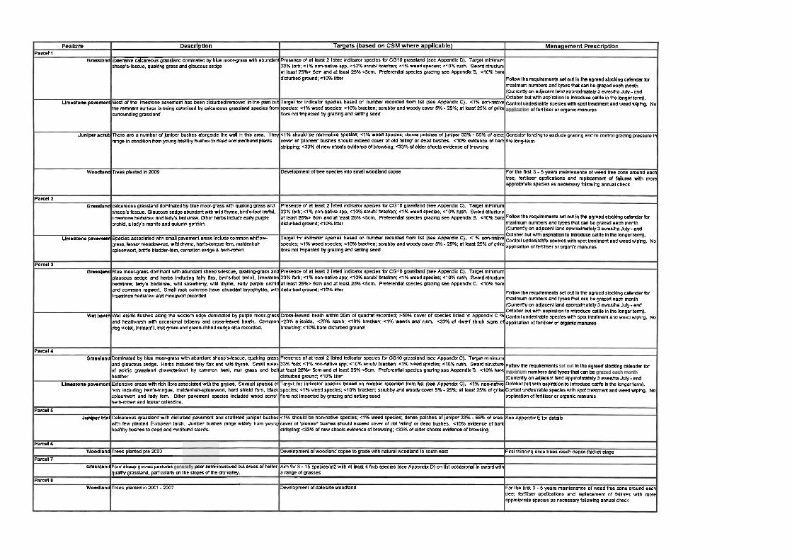
Fea tu re Parcel 1
Grassland
Llmestone pavement
Junlperscrub
Woodland
Parcel 2 Grassland
Llmestone pavement
Parcel 3 Grassland
Wet heath
Parcel 4 Grassland
Limestone pavcmem
Parcel 5 Junlpertrlal
Parcel 6 Woodland
Parcel 7 Grassland
Parcel 8 Woodland
Descr ip t ion
Exlensive calcareous grassland dominated by blue moor-grass with abundant sheep's-fescue, quaking grass and glaucous sedge
Most of the limestone pavement has been disturbedlremowd in the past but the remnant surface is being colonised by calcareous grassland species from sumunding grassland
There are a number of Juniper bushes alongside the wall in this area. They range in condition horn young healthy bushcsto dead and moribund plants
Trees planted in 2009
calcareous grassland dominated by blue moor-grass with quaking grass and sheep's fescue. Glaumus sedge abundant wlh wild thyme, bird'r-faot trefoil. limestone bedstraw and lady's bedstraw. Oiher herbs include early purple orchid, a lady's mantle and autumn gentian
Species associated mth small pavement areas include common whitlow- grass, lesser meadowrue. wild thyme, har?stongue fem, maidenhair spleenwan, bri!tle bladder-fem, carnation sedge 8 herb-robert
Blue moorgrass dominant wlh abundant sheep's-fescue, quaking-grass and glaucous Sedge and herbs including fairy lax, bird's-foot trefoil, limestone bedstraw. lady's bedstraw, wiid strawbeny, wild thyme, early purple orchid and Common ragwort. Small rock outcrops have abundant bryophges. with ilmestone bedstraw and moomvor! recorded
Wet acidic lushes along the westem edge dominated by purple mwr-grass and heathrush wi(h occasional bilbeny and crossleaved heath. Common dog violet, tormentit, mat grass and green-rlbbed sedge also recnrded.
Dominated by blue moor-grass with abundant sheep'sfescue, quaking grass and glaucous sedge. Herbs included fairy flax and wiid thyme. Small areas of acidic grassland characteked by common bent, mat grass and bell heather Extensive areas with rich flora associated with the grykes. Several species or fern including hart'stongue, maidenhair-spleenwar!, hard shield fern, black spleenwort and lady fem. Other pavement species included wood sorrel herb-robert and lesser celandine.
Calcareous grassland with disturbed pavement and scattered juniper bushes with few planted European larch. Juniper bushes range widely horn young heallhy bushes to dead and moribund stands.
Trees planted pre 2000
Four sheep grazed pastures ru.2 =.~~~~~rnproved but areas of better quality grassland, parlicularly on the slopes of the dry mlley.
Trees planted in 2001 - 2047
Targets (based on CSM w h e r e appl icab le)
Presence of at least 2 listed indicator species for CGlO grassland (See Appendix C). Target minimum 33% forb: -3% nonnative spp; 4 0 % scrub1 bracken; 4 % weed species: 4 0 % mrh. Sward structure at least 25%> 5cm and at least 25% c5cm. Preferential species grazing see Appendix B. <lo% bare disturbed ground: ~ 1 0 % litter
Target for indicator species based on number reWrded from list (See Appendix C). <I% non-native species: c l % weed specles: <I056 bracken: scrubby and woody cover 5% - 25%; at lean 25% of grike flora not Impacted by grazing and selling seed
4 % should be non-native species: cl% Weed species: dense patches of juniper 33% - 66% of area; uwer of 'pioneef bushes should exceed cover of old 'ailing' or dead bushes. 4 0 % evidence of baa stripping: ~ 3 3 % of new shoots evldence of browsing: <33% of older shoots evidence of browsing
Development of tree species into small woadland copse
Presence of at least 2 iisted indicator species for CGlO grassland (see Appendii C). Target minimum 33% forb; 4 % non-native spp: c10% scrubl bracken: 4 % weed species: 4 0 % rush. Sward structure at least 25%> 5cm and at ieast 25% <5cm. Preferential species grazing see Appendx B. ~ 1 0 % bare disturbed ground: <lo% imer
Target for indicator species based on number recorded horn llst (see Appendix C). <I% non-native species: 4 % weed species; 4 0 % bracken: scrubby and woody cover 5% - 25%: at least 25% of grike flora not impacted by grazing and selling seed
Presence of at least 2 i i e d indicator specles for CGlO grassland (see Appendix C). Target minimum 33% forb; c l % non-native spp: 4 0 % scrubl bracken: C1% weed specles; 410% rush. Sward structure at least 25% 5cm and at least 25% c5cm. Preferential species grazing see Appendix C. 4 0 % bare disturbed ground: elOK liner
Cross-leaved heath within 20m of quadrat recorded; >SO% cover of species listed in Appendix C % 220% ericoids. 420% scrub: clWb bracken: -4% weeds and rush. ~ 3 3 % of dwarf shrub signs of browsing: clO% bare disturbed ground
Presence of at lean 2 listed indicator species for CG10 grassland (see Appendix C). Target minimum 33% forb: 4 % non-native spp; 4 0 % scrubl bracken: 4 % weed species; 4 0 % rush. Sward structure at least 25%2 5cm and at least 25% <5cm. Preferential species grazing see Appendix B. ~ 1 0 % bare disturbed ground: clO% liter Target for indicator species based on number recorded horn iist (see Appendix C). c l % non-native species: 4 % weed species: c10% bracken: scrubby and woody cover 5% - 25%: at ieast 25% of grike flora not impacted by grazing and sewing seed
<I% should be non-natiw species; 4 % weed species; dense patches of juniper 33% - 66% of area: cover of 'pioneef bushes should exceed cover of old 'ailing' or dead bushes. ~ 1 0 % evidence of bark stripping; 6 3 % of new shoots evidence of brawsing; 433% of older shoots ewence of browsing
Development ofwoodiand copse to grade wlh natural woodland to south east
Aim for 8 - 15 specieslm2 wlh at least 4 forb species (see Appendix D) on iist occasional in sward with a range of grasses
Development of daleside woodland
Managemen t P resc r i p t i on
Follow the requirements set out In the agreed stocking calendar (or maximum numbers and types that can be grazed each month (Currently on adjacent land approximately 3 ewesha July - end October but with aspiration to introduce canie in the longerterm). control undesirable species spot treatment and weed wiping, No
offer!jliser or organic manures
Consider fencing10 exclude grezing andto control grazing pressure in the long-term
For the first 3 - 5 years maintenance of weed free zone around each tree: fertiliser applications and replacement of failures wlth more approipriate species as necessary following annual check
FollMV the requiremtnls set Mil In the agreed stocklng calendar for maximum numbers and types that can be grazed each month (Currently on adjacent land approximately 3 eweslha July - end October but with cattle iongerterm)'
~ ~ $ ~ ~ d , " , ? ~ . ~ ~ ~ ~ , " ~ ~ ~ r:A:::tmenl and Weed wiping' No
Fol lw the requirements set wt In the agreed stocking calendar for mm%num numbers and types that can be grazed each month (Cunenfly on adjacent land approximately 3 eweslha July- end October but wlh aspiration to introduce cattle in the longerterm). contrnl undeslrabie specieswnh spottreatment and weed wiping. No application offefiiiiser or
~ ~ l l ~ t h ~ raqu~menls in the agrKd stocking calendar (or numbers types can be
(Currently on adjacent land approximately 3 ewesma July- end October but with aspiration to introduce canle in the longer term). Control undesirable species with spot treatment and weed wiping. No application of fertiliser or organic manures
See Appendix E for details
Flrstthinning oncetrees reach dense thicket stage
For the first 3 - 5 years maintenance of weed free zone around each tree; ferlitiser applications and replacement of failures with mare apprnipriate species as necessary following annual check

kgc0M Horton in Ribblesdale Quarry Interim Habitat Management Plan
Figure I - Land Parcels and Statutory Designations
Hanson Aggregated49343429 Hanson 201 lU)BRP0004PRBPRB February 2016
Final 18