isprs activities on e-learning in photogrammetry, remote ...€¦ · isprs activities on e-learning...
TRANSCRIPT
Gerhard König, Mark Shortis and Christiane Katterfeld ISPRS activities on E-Learning in photogrammetry, remote sensing and GIS – status and Challenges Sharing Good Practices: E-learning in Surveying, Geo-information Sciences and Land Administration FIG International Workshop 2008 Enschede, The Netherlands, 11-13 June 2008
1/20
ISPRS activities on e-learning in photogrammetry, remote sensing and GIS – status and challenges
Gerhard KÖNIG, Germany, Mark SHORTIS, Australia and
Christiane KATTERFELD, Germany
Key words: ISPRS, e-learning, CATCON, quality assurance SUMMARY
This paper will review the status of computer aided teaching advances during the last decade, with a particular emphasis on photogrammetry and remote sensing. A range of examples will be presented, many of which will be drawn from the Computer Aided Teaching Contests (CATCON), sponsored by ISPRS Commission VI, Working Group 2, during 1996-2006. The consideration of these resources will include a commentary on the levels of adoption, an evaluation of quality of the material and the perceived effectiveness of computer aided teaching.
Gerhard König, Mark Shortis and Christiane Katterfeld ISPRS activities on E-Learning in photogrammetry, remote sensing and GIS – status and Challenges Sharing Good Practices: E-learning in Surveying, Geo-information Sciences and Land Administration FIG International Workshop 2008 Enschede, The Netherlands, 11-13 June 2008
2/20
ISPRS activities on E-Learning in photogrammetry, remote sensing and GIS – status and Challenges
Gerhard KÖNIG, Germany, Mark SHORTIS, Australia and
Christiane KATTERFELD, Germany 1. INTRODUCTION During the last two decades a number of factors have combined to encourage, and indeed force, the adoption of new teaching and learning methods in tertiary education. Not least of these has been the Internet-driven increase in the volume and complexity of the available information in any discipline. Simultaneously, there has been a rapid increase in the demand by employers and professional accreditation authorities for graduates with high levels of design, problem solving, teamwork, and communication skills. Of course these challenges were recognized by the scientific organizations and consequently the International Society for Photogrammetry and Remote Sensing (ISPRS) established the Working Group (WG) VI/2: Computer Assisted Teaching (CAT) in 1992 within the framework of the ISPRS Commission VI (Education and Outreach). Since 2004 WG VI/2 is renamed as E-Learning and is responsible for − Collection, analysis, dissemination and promotion of material, software and data
(hardcopy and/or softcopy) for e-learning including computer assisted teaching and distance learning.
− Investigation of the role of e-learning in modern education and training such as material, methodologies and tools.
− Assessment and evaluation of highly interactive multimedia material and the transformation of tertiary level courses in remote sensing, photogrammetry and SIS.
Since 1992, the WG has been organizing workshops, hands-on training, and seminars, issuing newsletters, disseminating software/data sets and many other activities. The results of these events are published in the corresponding proceedings or are accessible online (e.g. http://www.isprs.org/publications.html). 2. CATCON E-learning courses offered on the Internet are regarded as valuable contribution to education and training. Even participants at remote places are able study and communicate with their teachers and fellow-students which gives them a chance to participate in our "Information Society" where knowledge and creativity are the key factors. ISPRS decided to offer an incentive as encouragement to develop freely available material: in December 1995 ISPRS Commission VI proposed the plan to launch a competition promoting e-learning software development. CATCON was borne, the Computer Assisted Teaching CONtest organised by WG VI/2 (Cho, 1997; Koenig and Shortis, 2008). The primary
Gerhard König, Mark Shortis and Christiane Katterfeld ISPRS activities on E-Learning in photogrammetry, remote sensing and GIS – status and Challenges Sharing Good Practices: E-learning in Surveying, Geo-information Sciences and Land Administration FIG International Workshop 2008 Enschede, The Netherlands, 11-13 June 2008
3/20
objective of the contest is to promote the development and dissemination of multimedia products, educational information and simulation packages for computer assisted teaching. In general, material submitted by contestants is required to be non-commercial and provided free of charge for not-for-profit use. The assessment of the submissions by the contestants for each CATCON is based on peer review by the working group VI/2 Chair(s) and various ISPRS office bearers. Certificates and monetary prizes, supported by the ISPRS Foundation - Gold, Silver, and Bronze Award (2008: US$ 1,000; 700, and 500) - are awarded to the three submissions that are judged to be the most innovative and address the following criteria: − Ease and clarity of use − Sophistication of material − Relevance to education and training − Free availability − Free of hardware and software restrictions
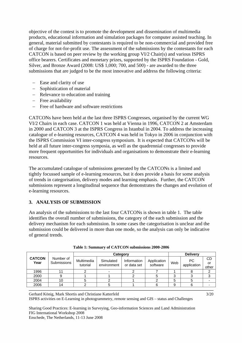
CATCONs have been held at the last three ISPRS Congresses, organised by the current WG VI/2 Chairs in each case. CATCON 1 was held at Vienna in 1996, CATCON 2 at Amsterdam in 2000 and CATCON 3 at the ISPRS Congress in Istanbul in 2004. To address the increasing catalogue of e-learning resources, CATCON 4 was held in Tokyo in 2006 in conjunction with the ISPRS Commission VI inter-congress symposium. It is expected that CATCONs will be held at all future inter-congress symposia, as well as the quadrennial congresses to provide more frequent opportunities for individuals and organisations to demonstrate their e-learning resources. The accumulated catalogue of submissions generated by the CATCONs is a limited and tightly focussed sample of e-learning resources, but it does provide a basis for some analysis of trends in categorisation, delivery modes and learning emphasis. Further, the CATCON submissions represent a longitudinal sequence that demonstrates the changes and evolution of e-learning resources. 3. ANALYSIS OF SUBMISSION An analysis of the submissions to the last four CATCONs is shown in table 1. The table identifies the overall number of submissions, the category of the each submission and the delivery mechanism for each submission. In some cases the categorisation is unclear and the submission could be delivered in more than one mode, so the analysis can only be indicative of general trends.
Table 1: Summary of CATCON submissions 2000-2006
Category Delivery CATCON
Year Number of
Submissions Multimedia tutorial
Simulated environment
Information or data set
Application software Web PC
application
CD or
other 1996 11 2 - 2 7 1 8 2 2000 9 1 1 2 5 3 3 3 2004 10 5 2 1 2 5 5 - 2006 14 2 5 1 6 9 6 -
Gerhard König, Mark Shortis and Christiane Katterfeld ISPRS activities on E-Learning in photogrammetry, remote sensing and GIS – status and Challenges Sharing Good Practices: E-learning in Surveying, Geo-information Sciences and Land Administration FIG International Workshop 2008 Enschede, The Netherlands, 11-13 June 2008
4/20
Two clear trends in the delivery of e-learning material are evident in the table. First, distribution on CD-ROM is no longer common and delivery via a web page or as a PC application is predominant. Second, delivery via an Internet web page is clearly increasing. The trends for the category of the e-learning material are less clear, although the number of multimedia tutorials and simulated environments, as compared with data sets or application software, is increasing. Whilst teaching and learning imperatives such as student-centered learning and integrated assessment have not been directly part of the judging criteria, many of the CATCON submissions were certainly framed in a context of education at tertiary level. One aspect of the categorisation which is not evident from the table is that it has been more common for multimedia tutorials and simulated environments to incorporate engaging, interactive student-centred environments that suitably guide learning. This is reinforced by increases in the number and sophistication of simulated environments over the ten years. In contrast, most application software is more straightforward and either provides little guidance at all, or includes a help system or case studies that are not well integrated into the e-learning material. Very few of the CATCON submissions have contained a component of assessment as part of the e-learning material. There have been instances of practice examples that provide formative assessment, especially within multimedia tutorials, but in general the e-learning material has concentrated on the delivery of learning rather than the assessment of the acquired capabilities of the learner. The engagement and assessment aspects of the CATCON submissions have not been documented, however the judging panels have very often remarked on these issues. 4. EXAMPLES OF E-LEARNING COURSES Around the word a variety of well-designed e-learning products exist. On the web-pages of Commission VI/2 links to the authors known websites are listed (Koenig and Shortis, 2008). A more detailed overview of relevant e-learning software is in preparation. In the following sections a range of best practice examples are introduced. 4.1 Canada: Canadian Centre of Remote Sensing Tutorials The e-learning products of the Canadian Centre of Remote Sensing (CCRS) are classics among the tutorials. CCRS provides several interactive training modules mainly focused on remote sensing. They cover − Digital Images and Digital Analysis Techniques − Fundamentals of Remote Sensing, an overview to remote sensing − Radar Polarimetry, introduction to the principle, technology and practical applications of
radar polarimetry. − Radar Remote Sensing, a comprehensive and unique set of radar remote sensing training
materials
− Radar and Stereoscopy touches on relevant aspects of stereoscopy and radar remote sensing, with special focus on the use of RADARSAT imagery
− RADARSAT-1 Stereo Advisor, demonstrates how SAR images are used for creation of a digital elevation model
− Satellite Data Reception, an animated tool explaining how data acquisition works − Image Interpretation Quiz, an interactive quiz to familiarise with interpretation technique − Watching over our Planet from Space, a tutorial especially for school-age children
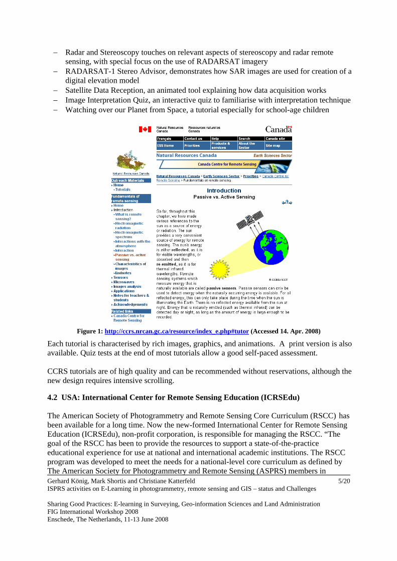
Figure 1: http://ccrs.nrcan.gc.ca/resource/index_e.php#tutor (Accessed 14. Apr. 2008)
Each tutorial is characterised by rich images, graphics, and animations. A print version is also available. Quiz tests at the end of most tutorials allow a good self-paced assessment. CCRS tutorials are of high quality and can be recommended without reservations, although the new design requires intensive scrolling. 4.2 USA: International Center for Remote Sensing Education (ICRSEdu) The American Society of Photogrammetry and Remote Sensing Core Curriculum (RSCC) has been available for a long time. Now the new-formed International Center for Remote Sensing Education (ICRSEdu), non-profit corporation, is responsible for managing the RSCC. “The goal of the RSCC has been to provide the resources to support a state-of-the-practice educational experience for use at national and international academic institutions. The RSCC program was developed to meet the needs for a national-level core curriculum as defined by The American Society for Photogrammetry and Remote Sensing (ASPRS) members in Gerhard König, Mark Shortis and Christiane Katterfeld ISPRS activities on E-Learning in photogrammetry, remote sensing and GIS – status and Challenges Sharing Good Practices: E-learning in Surveying, Geo-information Sciences and Land Administration FIG International Workshop 2008 Enschede, The Netherlands, 11-13 June 2008
5/20
cooperation with the National Center for Geographic Information and Analysis (NCGIA), National Aeronautic and Space Administration (NASA) and Earth Observation Satellite Company (EOSAT). This curriculum currently represents a collection of the highest quality resource materials available in this dynamic technological field for use at collegiate levels. RSCC was initiated under a NASA grant to form a consortium of experts from academia and industry. (http://www.icrsed.org/).
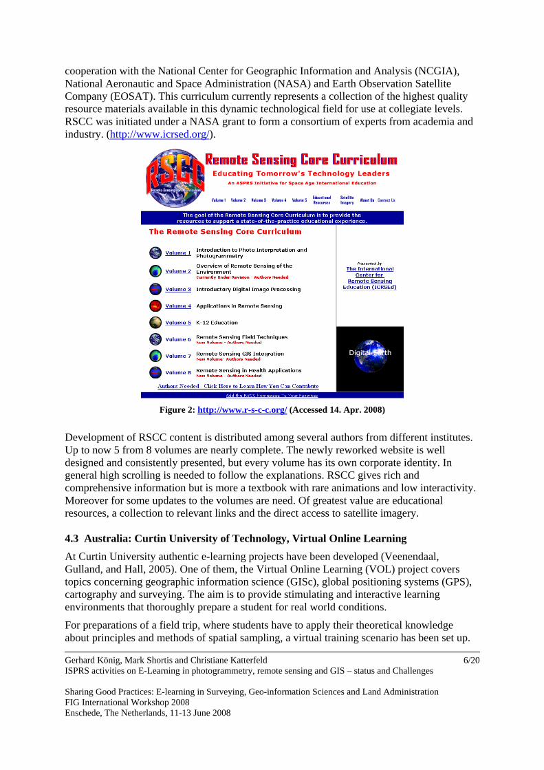
Figure 2: http://www.r-s-c-c.org/ (Accessed 14. Apr. 2008)
Development of RSCC content is distributed among several authors from different institutes. Up to now 5 from 8 volumes are nearly complete. The newly reworked website is well designed and consistently presented, but every volume has its own corporate identity. In general high scrolling is needed to follow the explanations. RSCC gives rich and comprehensive information but is more a textbook with rare animations and low interactivity. Moreover for some updates to the volumes are need. Of greatest value are educational resources, a collection to relevant links and the direct access to satellite imagery. 4.3 Australia: Curtin University of Technology, Virtual Online Learning At Curtin University authentic e-learning projects have been developed (Veenendaal, Gulland, and Hall, 2005). One of them, the Virtual Online Learning (VOL) project covers topics concerning geographic information science (GISc), global positioning systems (GPS), cartography and surveying. The aim is to provide stimulating and interactive learning environments that thoroughly prepare a student for real world conditions.
For preparations of a field trip, where students have to apply their theoretical knowledge about principles and methods of spatial sampling, a virtual training scenario has been set up.
Gerhard König, Mark Shortis and Christiane Katterfeld ISPRS activities on E-Learning in photogrammetry, remote sensing and GIS – status and Challenges Sharing Good Practices: E-learning in Surveying, Geo-information Sciences and Land Administration FIG International Workshop 2008 Enschede, The Netherlands, 11-13 June 2008
6/20
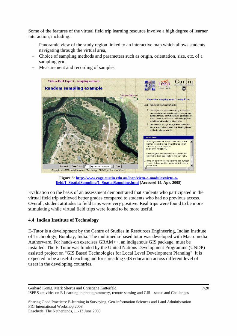
Some of the features of the virtual field trip learning resource involve a high degree of learner interaction, including:
− Panoramic view of the study region linked to an interactive map which allows students navigating through the virtual area,
− Choice of sampling methods and parameters such as origin, orientation, size, etc. of a sampling grid,
− Measurement and recording of samples.
Figure 3: http://www.cage.curtin.edu.au/leap/virtu-o-modules/virtu-o-
field/1_SpatialSampling/1_SpatialSampling.html (Accessed 14. Apr. 2008)
Evaluation on the basis of an assessment demonstrated that students who participated in the virtual field trip achieved better grades compared to students who had no previous access. Overall, student attitudes to field trips were very positive. Real trips were found to be more stimulating while virtual field trips were found to be more useful. 4.4 Indian Institute of Technology E-Tutor is a development by the Centre of Studies in Resources Engineering, Indian Institute of Technology, Bombay, India. The multimedia-based tutor was developed with Macromedia Authorware. For hands-on exercises GRAM++, an indigenous GIS package, must be installed. The E-Tutor was funded by the United Nations Development Programme (UNDP) assisted project on "GIS Based Technologies for Local Level Development Planning". It is expected to be a useful teaching aid for spreading GIS education across different level of users in the developing countries.
Gerhard König, Mark Shortis and Christiane Katterfeld ISPRS activities on E-Learning in photogrammetry, remote sensing and GIS – status and Challenges Sharing Good Practices: E-learning in Surveying, Geo-information Sciences and Land Administration FIG International Workshop 2008 Enschede, The Netherlands, 11-13 June 2008
7/20
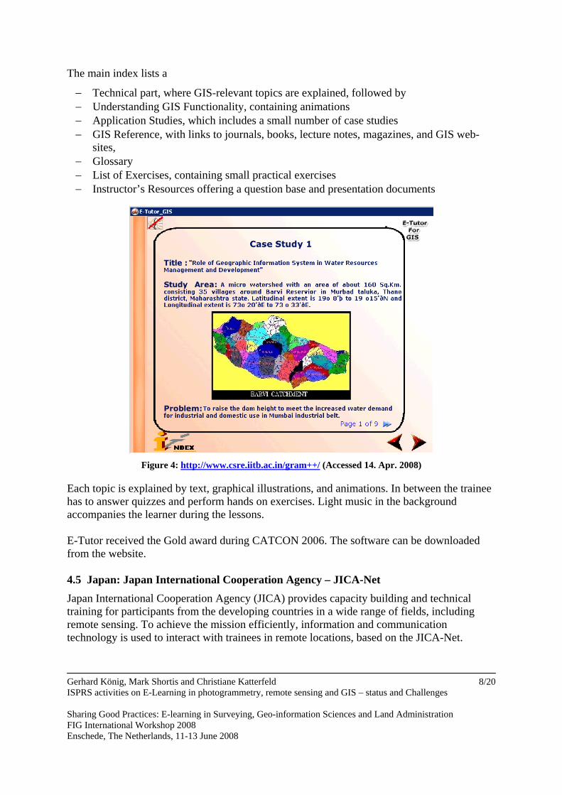
The main index lists a
− Technical part, where GIS-relevant topics are explained, followed by − Understanding GIS Functionality, containing animations − Application Studies, which includes a small number of case studies − GIS Reference, with links to journals, books, lecture notes, magazines, and GIS web-
sites, − Glossary − List of Exercises, containing small practical exercises − Instructor’s Resources offering a question base and presentation documents
Figure 4: http://www.csre.iitb.ac.in/gram++/ (Accessed 14. Apr. 2008)
Each topic is explained by text, graphical illustrations, and animations. In between the trainee has to answer quizzes and perform hands on exercises. Light music in the background accompanies the learner during the lessons. E-Tutor received the Gold award during CATCON 2006. The software can be downloaded from the website. 4.5 Japan: Japan International Cooperation Agency – JICA-Net
Japan International Cooperation Agency (JICA) provides capacity building and technical training for participants from the developing countries in a wide range of fields, including remote sensing. To achieve the mission efficiently, information and communication technology is used to interact with trainees in remote locations, based on the JICA-Net. Gerhard König, Mark Shortis and Christiane Katterfeld ISPRS activities on E-Learning in photogrammetry, remote sensing and GIS – status and Challenges Sharing Good Practices: E-learning in Surveying, Geo-information Sciences and Land Administration FIG International Workshop 2008 Enschede, The Netherlands, 11-13 June 2008
8/20
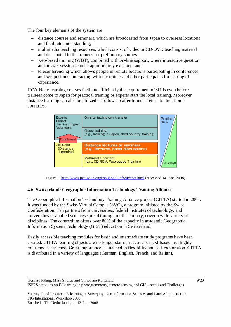
The four key elements of the system are
− distance courses and seminars, which are broadcasted from Japan to overseas locations and facilitate understanding,
− multimedia teaching resources, which consist of video or CD/DVD teaching material and distributed to the trainees for preliminary studies
− web-based training (WBT), combined with on-line support, where interactive question and answer sessions can be appropriately executed, and
− teleconferencing which allows people in remote locations participating in conferences and symposiums, interacting with the trainer and other participants for sharing of experience.
JICA-Net e-learning courses facilitate efficiently the acquirement of skills even before trainees come to Japan for practical training or experts start the local training. Moreover distance learning can also be utilized as follow-up after trainees return to their home countries.
Figure 5: http://www.jica.go.jp/english/global/info/jicanet.html (Accessed 14. Apr. 2008)
4.6 Switzerland: Geographic Information Technology Training Alliance The Geographic Information Technology Training Alliance project (GITTA) started in 2001. It was funded by the Swiss Virtual Campus (SVC), a program initiated by the Swiss Confederation. Ten partners from universities, federal institutes of technology, and universities of applied sciences spread throughout the country, cover a wide variety of disciplines. The consortium offers over 80% of the capacity in academic Geographic Information System Technology (GIST) education in Switzerland. Easily accessible teaching modules for basic and intermediate study programs have been created. GITTA learning objects are no longer static-, reactive- or text-based, but highly multimedia-enriched. Great importance is attached to flexibility and self-exploration. GITTA is distributed in a variety of languages (German, English, French, and Italian).
Gerhard König, Mark Shortis and Christiane Katterfeld ISPRS activities on E-Learning in photogrammetry, remote sensing and GIS – status and Challenges Sharing Good Practices: E-learning in Surveying, Geo-information Sciences and Land Administration FIG International Workshop 2008 Enschede, The Netherlands, 11-13 June 2008
9/20
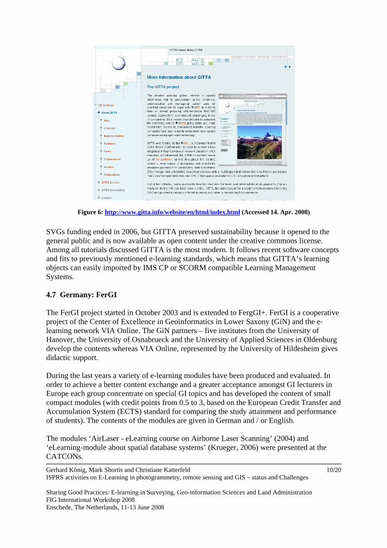
Figure 6: http://www.gitta.info/website/en/html/index.html (Accessed 14. Apr. 2008)
SVGs funding ended in 2006, but GITTA preserved sustainability because it opened to the general public and is now available as open content under the creative commons license. Among all tutorials discussed GITTA is the most modern. It follows recent software concepts and fits to previously mentioned e-learning standards, which means that GITTA’s learning objects can easily imported by IMS CP or SCORM compatible Learning Management Systems. 4.7 Germany: FerGI The FerGI project started in October 2003 and is extended to FergGI+. FerGI is a cooperative project of the Center of Excellence in Geoinformatics in Lower Saxony (GiN) and the e-learning network VIA Online. The GiN partners – five institutes from the University of Hanover, the University of Osnabrueck and the University of Applied Sciences in Oldenburg develop the contents whereas VIA Online, represented by the University of Hildesheim gives didactic support. During the last years a variety of e-learning modules have been produced and evaluated. In order to achieve a better content exchange and a greater acceptance amongst GI lecturers in Europe each group concentrate on special GI topics and has developed the content of small compact modules (with credit points from 0.5 to 3, based on the European Credit Transfer and Accumulation System (ECTS) standard for comparing the study attainment and performance of students). The contents of the modules are given in German and / or English. The modules ‘AirLaser - eLearning course on Airborne Laser Scanning’ (2004) and ‘eLearning-module about spatial database systems’ (Krueger, 2006) were presented at the CATCONs.
Gerhard König, Mark Shortis and Christiane Katterfeld ISPRS activities on E-Learning in photogrammetry, remote sensing and GIS – status and Challenges Sharing Good Practices: E-learning in Surveying, Geo-information Sciences and Land Administration FIG International Workshop 2008 Enschede, The Netherlands, 11-13 June 2008
10/20
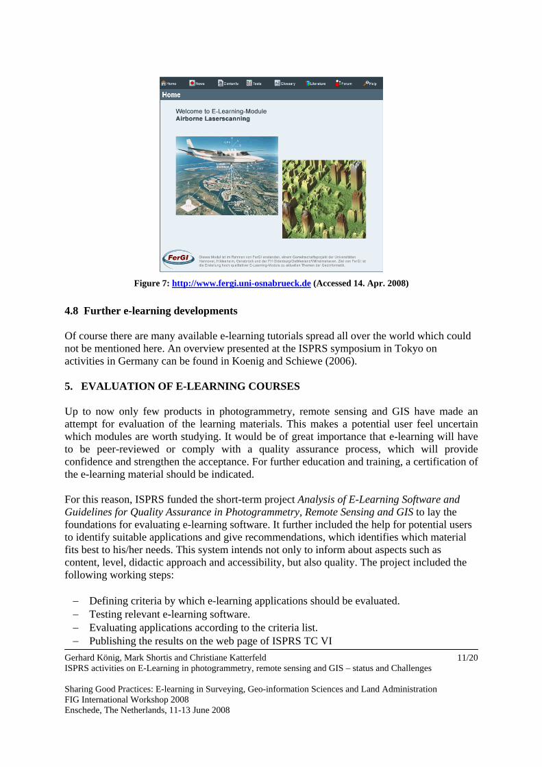
Figure 7: http://www.fergi.uni-osnabrueck.de (Accessed 14. Apr. 2008)
4.8 Further e-learning developments Of course there are many available e-learning tutorials spread all over the world which could not be mentioned here. An overview presented at the ISPRS symposium in Tokyo on activities in Germany can be found in Koenig and Schiewe (2006). 5. EVALUATION OF E-LEARNING COURSES Up to now only few products in photogrammetry, remote sensing and GIS have made an attempt for evaluation of the learning materials. This makes a potential user feel uncertain which modules are worth studying. It would be of great importance that e-learning will have to be peer-reviewed or comply with a quality assurance process, which will provide confidence and strengthen the acceptance. For further education and training, a certification of the e-learning material should be indicated. For this reason, ISPRS funded the short-term project Analysis of E-Learning Software and Guidelines for Quality Assurance in Photogrammetry, Remote Sensing and GIS to lay the foundations for evaluating e-learning software. It further included the help for potential users to identify suitable applications and give recommendations, which identifies which material fits best to his/her needs. This system intends not only to inform about aspects such as content, level, didactic approach and accessibility, but also quality. The project included the following working steps: − Defining criteria by which e-learning applications should be evaluated. − Testing relevant e-learning software. − Evaluating applications according to the criteria list. − Publishing the results on the web page of ISPRS TC VI
Gerhard König, Mark Shortis and Christiane Katterfeld ISPRS activities on E-Learning in photogrammetry, remote sensing and GIS – status and Challenges Sharing Good Practices: E-learning in Surveying, Geo-information Sciences and Land Administration FIG International Workshop 2008 Enschede, The Netherlands, 11-13 June 2008
11/20
Gerhard König, Mark Shortis and Christiane Katterfeld ISPRS activities on E-Learning in photogrammetry, remote sensing and GIS – status and Challenges Sharing Good Practices: E-learning in Surveying, Geo-information Sciences and Land Administration FIG International Workshop 2008 Enschede, The Netherlands, 11-13 June 2008
12/20
The results of the project will be delivered to ISPRS for evaluation by experts. It is suggested that Commission VI forms a board, to act as a “brains trust”, at XXI ISPRS Congress in Beijing. This board should define an objective process for the full accomplishment of step 3 (Evaluation of E-Learning-Software). 5.1 Defining quality criteria Quality is the most important factor determining acceptance of e-learning products. But developing high-quality material is a great challenge. It is nearly impossible to meet the demands of all parties involved having different perspectives on quality:
• from learners’ view the structure of the course should facilitate long-term learning results,
• teachers perspectives focus on the quality of content and emphasises that materials met their requirements; openness and interoperability are also main topic
• developers are interested in the quality of code which is a prerequisite for reuse making the e-learning modules profitable
• government interest aims at making education more effective with constant or even decreasing investigations
• business attract notice to a praxis oriented modern curriculum meeting the emerging demands of the employers
Moreover the term ‘quality’ is highly dependant on social background, regional provenance, and cultural imprint. Whilst in the USA the technical quality is a key, in Europe the didactical approach is in the spotlight. The choice of criteria used for the checklist applied in the ISPRS study is oriented at the Reference Quality Criteria Catalogues for E-Learning (QCC-eL) described in Berger & Rockmann (2006) as well as on the Framework for E-Learning Quality by Anderson & MacCormick (2006). The QCC-eL is part of a technical specification for open interfaces (the Public Available Specification (PAS) 1032-1 of the German Institute for Standardisation), and also annexed to the ISO Standard ISO/ IEC 19796-1. The criteria operationalise relevant ISO-standards for software and multimedia user interfaces (e.g. ISO 9241 – principles for dialogues between humans and IT systems; ISO 14915 – design principles for multimedia user interfaces and organisation of content), relevant laws and regulations (e.g. data protection laws, distance learning protection act, ordinance on barrier-free information technology), consolidated empirical findings from relevant scientific areas (Berger & Rockmann, 2006) and incorporate pedagogical/ didactic issues particularly. The Framework for E-Learning Quality by Anderson & MacCormick (2006) is an overarching framework. Its role is to provide a high-level overview of all relevant quality components developed within a British initiative to improve national E-Learning. The QCC-eL list and the Framework for E-Learning Quality were adapted by the authors of the ISPRS study and are listed in detail in Table 2.
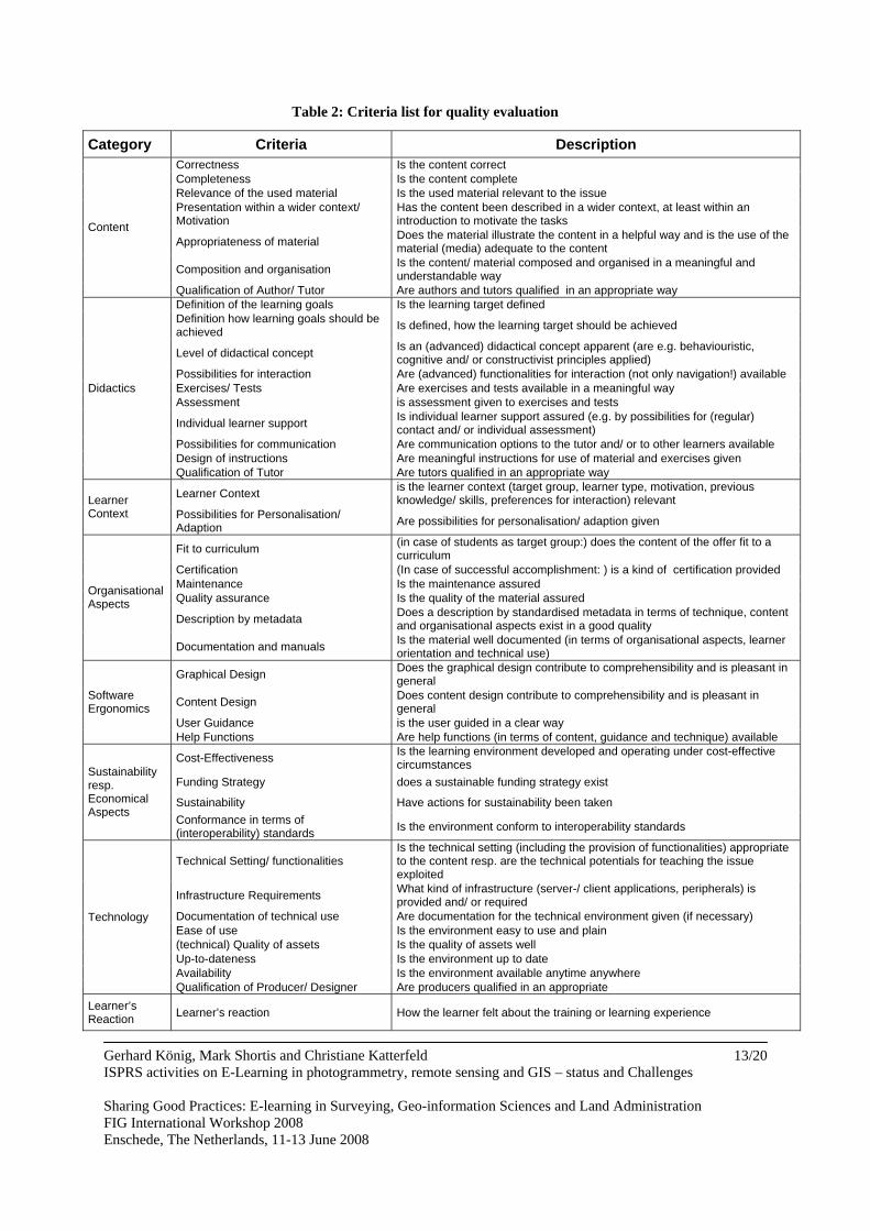
Table 2: Criteria list for quality evaluation
Category Criteria Description Correctness Is the content correct Completeness Is the content complete Relevance of the used material Is the used material relevant to the issue Presentation within a wider context/ Motivation
Has the content been described in a wider context, at least within an introduction to motivate the tasks
Appropriateness of material Does the material illustrate the content in a helpful way and is the use of the material (media) adequate to the content
Composition and organisation Is the content/ material composed and organised in a meaningful and understandable way
Content
Qualification of Author/ Tutor Are authors and tutors qualified in an appropriate way Definition of the learning goals Is the learning target defined Definition how learning goals should be achieved Is defined, how the learning target should be achieved
Level of didactical concept Is an (advanced) didactical concept apparent (are e.g. behaviouristic, cognitive and/ or constructivist principles applied)
Possibilities for interaction Are (advanced) functionalities for interaction (not only navigation!) available Exercises/ Tests Are exercises and tests available in a meaningful way Assessment is assessment given to exercises and tests
Individual learner support Is individual learner support assured (e.g. by possibilities for (regular) contact and/ or individual assessment)
Possibilities for communication Are communication options to the tutor and/ or to other learners available Design of instructions Are meaningful instructions for use of material and exercises given
Didactics
Qualification of Tutor Are tutors qualified in an appropriate way
Learner Context is the learner context (target group, learner type, motivation, previous knowledge/ skills, preferences for interaction) relevant Learner
Context Possibilities for Personalisation/ Adaption Are possibilities for personalisation/ adaption given
Fit to curriculum (in case of students as target group:) does the content of the offer fit to a curriculum
Certification (In case of successful accomplishment: ) is a kind of certification provided Maintenance Is the maintenance assured Quality assurance Is the quality of the material assured
Description by metadata Does a description by standardised metadata in terms of technique, content and organisational aspects exist in a good quality
Organisational Aspects
Documentation and manuals Is the material well documented (in terms of organisational aspects, learner orientation and technical use)
Graphical Design Does the graphical design contribute to comprehensibility and is pleasant in general
Content Design Does content design contribute to comprehensibility and is pleasant in general
User Guidance is the user guided in a clear way
Software Ergonomics
Help Functions Are help functions (in terms of content, guidance and technique) available
Cost-Effectiveness Is the learning environment developed and operating under cost-effective circumstances
Funding Strategy does a sustainable funding strategy exist
Sustainability Have actions for sustainability been taken
Sustainability resp. Economical Aspects
Conformance in terms of (interoperability) standards Is the environment conform to interoperability standards
Technical Setting/ functionalities Is the technical setting (including the provision of functionalities) appropriate to the content resp. are the technical potentials for teaching the issue exploited
Infrastructure Requirements What kind of infrastructure (server-/ client applications, peripherals) is provided and/ or required
Documentation of technical use Are documentation for the technical environment given (if necessary) Ease of use Is the environment easy to use and plain (technical) Quality of assets Is the quality of assets well Up-to-dateness Is the environment up to date Availability Is the environment available anytime anywhere
Technology
Qualification of Producer/ Designer Are producers qualified in an appropriate Learner’s Reaction Learner’s reaction How the learner felt about the training or learning experience
Gerhard König, Mark Shortis and Christiane Katterfeld ISPRS activities on E-Learning in photogrammetry, remote sensing and GIS – status and Challenges Sharing Good Practices: E-learning in Surveying, Geo-information Sciences and Land Administration FIG International Workshop 2008 Enschede, The Netherlands, 11-13 June 2008
13/20
Gerhard König, Mark Shortis and Christiane Katterfeld ISPRS activities on E-Learning in photogrammetry, remote sensing and GIS – status and Challenges Sharing Good Practices: E-learning in Surveying, Geo-information Sciences and Land Administration FIG International Workshop 2008 Enschede, The Netherlands, 11-13 June 2008
14/20
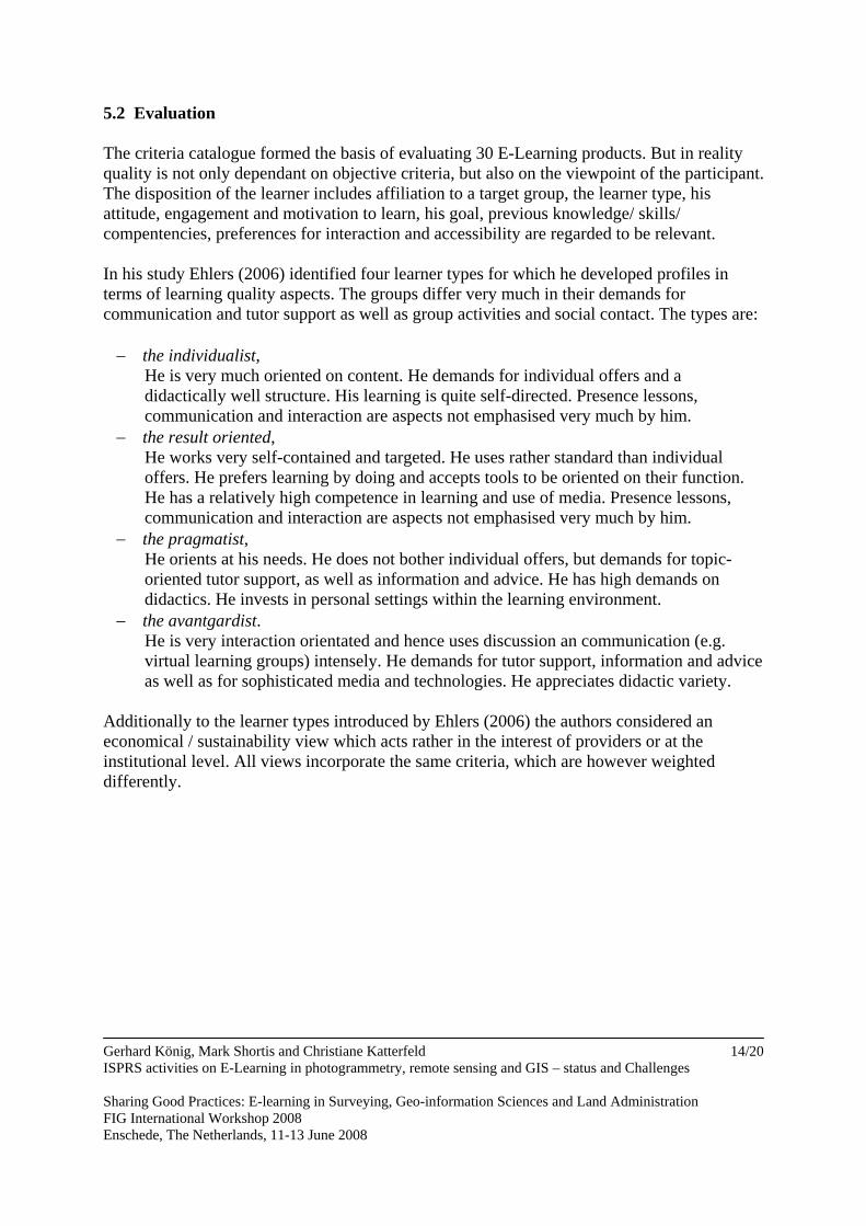
5.2 Evaluation The criteria catalogue formed the basis of evaluating 30 E-Learning products. But in reality quality is not only dependant on objective criteria, but also on the viewpoint of the participant. The disposition of the learner includes affiliation to a target group, the learner type, his attitude, engagement and motivation to learn, his goal, previous knowledge/ skills/ compentencies, preferences for interaction and accessibility are regarded to be relevant. In his study Ehlers (2006) identified four learner types for which he developed profiles in terms of learning quality aspects. The groups differ very much in their demands for communication and tutor support as well as group activities and social contact. The types are: − the individualist,
He is very much oriented on content. He demands for individual offers and a didactically well structure. His learning is quite self-directed. Presence lessons, communication and interaction are aspects not emphasised very much by him.
− the result oriented, He works very self-contained and targeted. He uses rather standard than individual offers. He prefers learning by doing and accepts tools to be oriented on their function. He has a relatively high competence in learning and use of media. Presence lessons, communication and interaction are aspects not emphasised very much by him.
− the pragmatist, He orients at his needs. He does not bother individual offers, but demands for topic-oriented tutor support, as well as information and advice. He has high demands on didactics. He invests in personal settings within the learning environment.
− the avantgardist. He is very interaction orientated and hence uses discussion an communication (e.g. virtual learning groups) intensely. He demands for tutor support, information and advice as well as for sophisticated media and technologies. He appreciates didactic variety.
Additionally to the learner types introduced by Ehlers (2006) the authors considered an economical / sustainability view which acts rather in the interest of providers or at the institutional level. All views incorporate the same criteria, which are however weighted differently.
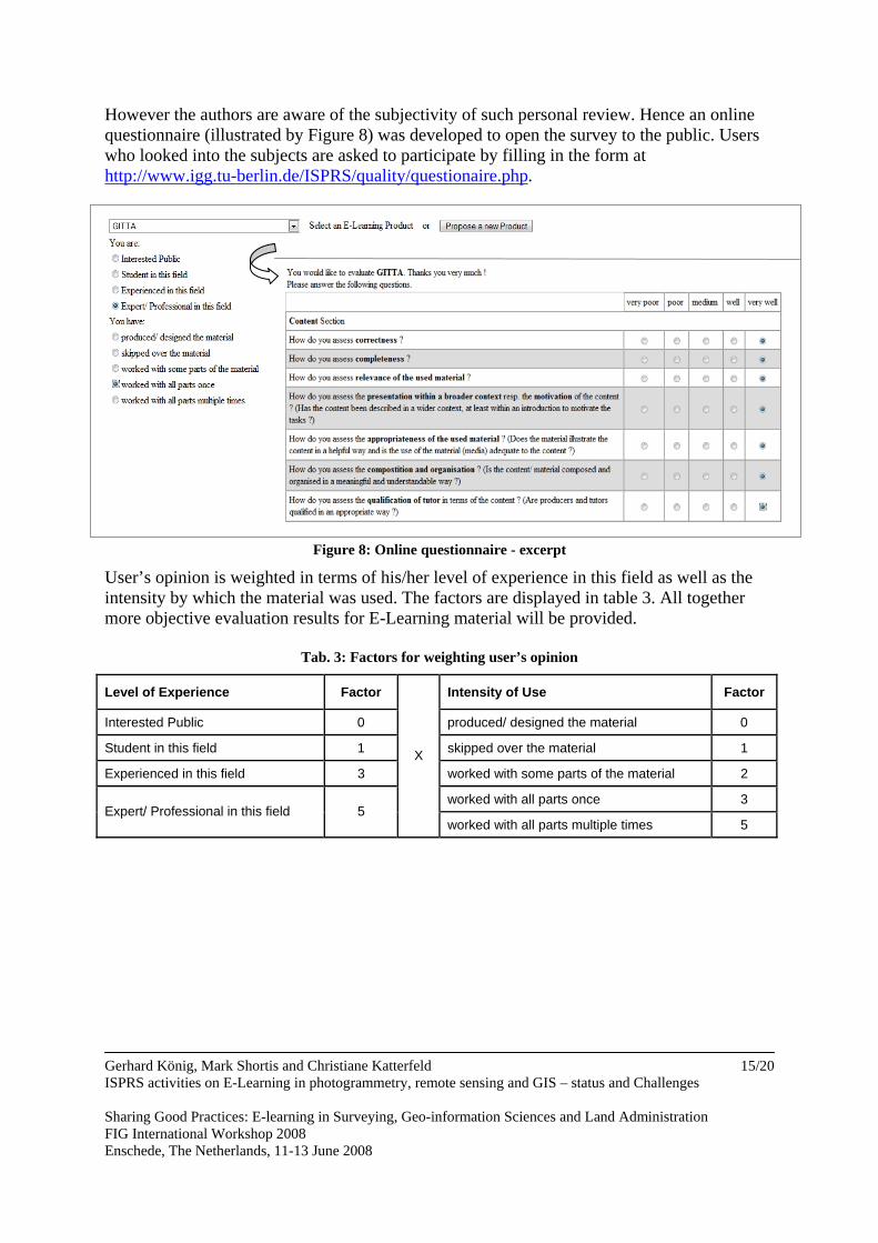
However the authors are aware of the subjectivity of such personal review. Hence an online questionnaire (illustrated by Figure 8) was developed to open the survey to the public. Users who looked into the subjects are asked to participate by filling in the form at http://www.igg.tu-berlin.de/ISPRS/quality/questionaire.php.
Figure 8: Online questionnaire - excerpt
User’s opinion is weighted in terms of his/her level of experience in this field as well as the intensity by which the material was used. The factors are displayed in table 3. All together more objective evaluation results for E-Learning material will be provided.
Tab. 3: Factors for weighting user’s opinion
Level of Experience Factor Intensity of Use Factor
Interested Public 0 produced/ designed the material 0
Student in this field 1 skipped over the material 1
Experienced in this field 3 worked with some parts of the material 2
worked with all parts once 3 Expert/ Professional in this field 5
X
worked with all parts multiple times 5
Gerhard König, Mark Shortis and Christiane Katterfeld ISPRS activities on E-Learning in photogrammetry, remote sensing and GIS – status and Challenges Sharing Good Practices: E-learning in Surveying, Geo-information Sciences and Land Administration FIG International Workshop 2008 Enschede, The Netherlands, 11-13 June 2008
15/20
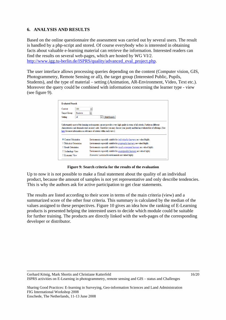
6. ANALYSIS AND RESULTS Based on the online questionnaire the assessment was carried out by several users. The result is handled by a php-script and stored. Of course everybody who is interested in obtaining facts about valuable e-learning material can retrieve the information. Interested readers can find the results on several web-pages, which are hosted by WG VI/2. http://www.igg.tu-berlin.de/ISPRS/quality/advanced_eval_project.php. The user interface allows processing queries depending on the content (Computer vision, GIS, Photogrammetry, Remote Sensing or all), the target group (Interested Public, Pupils, Students), and the type of material – setting (Animation, AR-Environment, Video, Text etc.). Moreover the query could be combined with information concerning the learner type - view (see figure 9).
Figure 9: Search criteria for the results of the evaluation
Up to now it is not possible to make a final statement about the quality of an individual product, because the amount of samples is not yet representative and only describe tendencies. This is why the authors ask for active participation to get clear statements. The results are listed according to their score in terms of the main criteria (view) and a summarized score of the other four criteria. This summary is calculated by the median of the values assigned to these perspectives. Figure 10 gives an idea how the ranking of E-Learning products is presented helping the interested users to decide which module could be suitable for further training. The products are directly linked with the web-pages of the corresponding developer or distributor.
Gerhard König, Mark Shortis and Christiane Katterfeld ISPRS activities on E-Learning in photogrammetry, remote sensing and GIS – status and Challenges Sharing Good Practices: E-learning in Surveying, Geo-information Sciences and Land Administration FIG International Workshop 2008 Enschede, The Netherlands, 11-13 June 2008
16/20
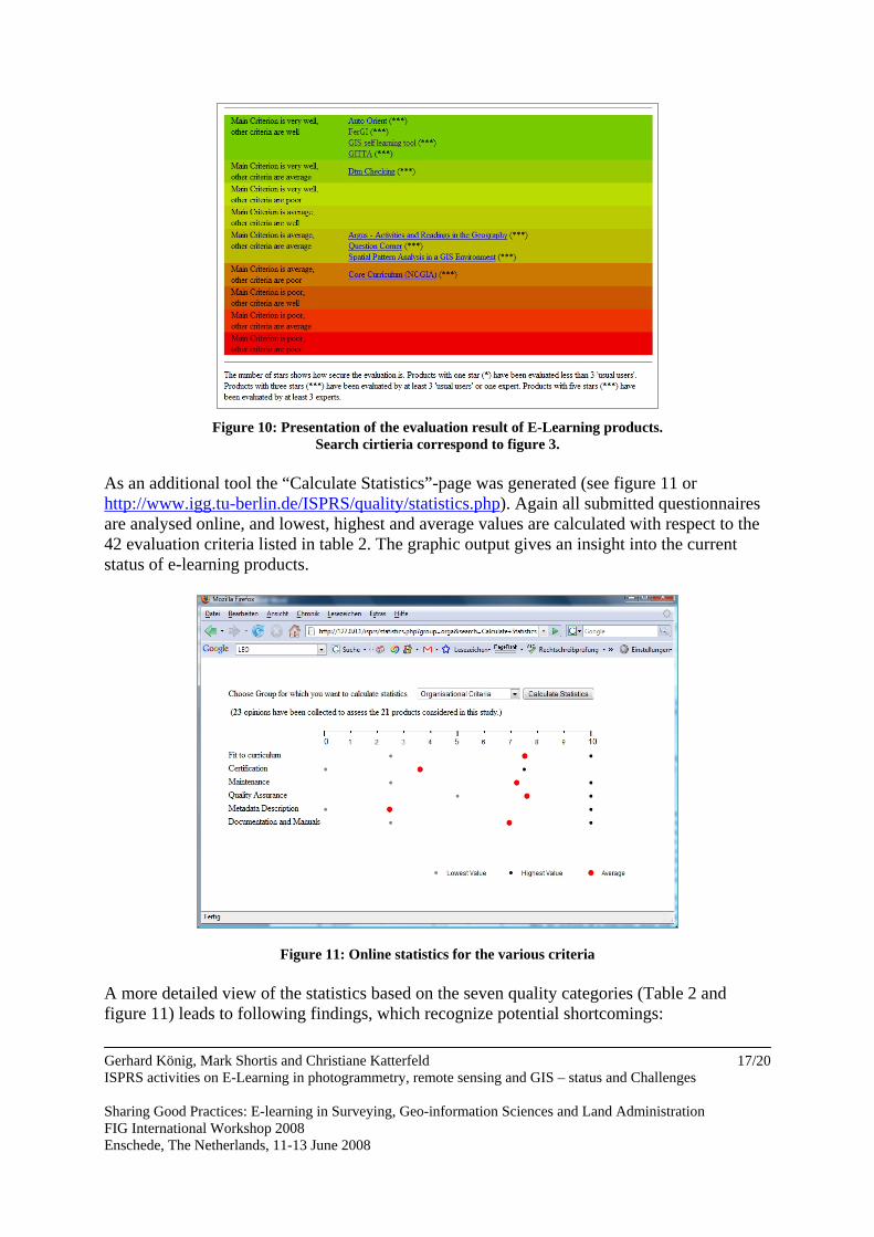
Figure 10: Presentation of the evaluation result of E-Learning products.
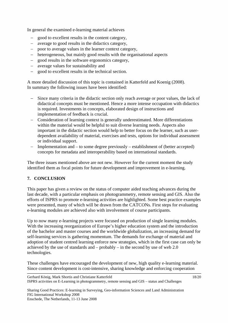
Search cirtieria correspond to figure 3. As an additional tool the “Calculate Statistics”-page was generated (see figure 11 or http://www.igg.tu-berlin.de/ISPRS/quality/statistics.php). Again all submitted questionnaires are analysed online, and lowest, highest and average values are calculated with respect to the 42 evaluation criteria listed in table 2. The graphic output gives an insight into the current status of e-learning products.
Figure 11: Online statistics for the various criteria A more detailed view of the statistics based on the seven quality categories (Table 2 and figure 11) leads to following findings, which recognize potential shortcomings: Gerhard König, Mark Shortis and Christiane Katterfeld ISPRS activities on E-Learning in photogrammetry, remote sensing and GIS – status and Challenges Sharing Good Practices: E-learning in Surveying, Geo-information Sciences and Land Administration FIG International Workshop 2008 Enschede, The Netherlands, 11-13 June 2008
17/20
Gerhard König, Mark Shortis and Christiane Katterfeld ISPRS activities on E-Learning in photogrammetry, remote sensing and GIS – status and Challenges Sharing Good Practices: E-learning in Surveying, Geo-information Sciences and Land Administration FIG International Workshop 2008 Enschede, The Netherlands, 11-13 June 2008
18/20
In general the examined e-learning material achieves
− good to excellent results in the content category, − average to good results in the didactics category, − poor to average values in the learner context category, − heterogeneous, but mainly good results with the organisational aspects − good results in the software ergonomics category, − average values for sustainability and − good to excellent results in the technical section.
A more detailed discussion of this topic is contained in Katterfeld and Koenig (2008). In summary the following issues have been identified: − Since many criteria in the didactic section only reach average or poor values, the lack of
didactical concepts must be mentioned. Hence a more intense occupation with didactics is required. Investments in concepts, elaborated design of instructions and implementation of feedback is crucial.
− Consideration of learning context is generally underestimated. More differentiations within the material would be helpful to suit diverse learning needs. Aspects also important in the didactic section would help to better focus on the learner, such as user-dependent availability of material, exercises and tests, options for individual assessment or individual support.
− Implementation and – to some degree previously – establishment of (better accepted) concepts for metadata and interoperability based on international standards.
The three issues mentioned above are not new. However for the current moment the study identified them as focal points for future development and improvement in e-learning. 7. CONCLUSION This paper has given a review on the status of computer aided teaching advances during the last decade, with a particular emphasis on photogrammetry, remote sensing and GIS. Also the efforts of ISPRS to promote e-learning activities are highlighted. Some best practice examples were presented, many of which will be drawn from the CATCONs. First steps for evaluating e-learning modules are achieved also with involvement of course participants. Up to now many e-learning projects were focused on production of single learning modules. With the increasing reorganization of Europe’s higher education system and the introduction of the bachelor and master courses and the worldwide globalization, an increasing demand for self-learning services is gathering momentum. The demands for exchange of material and adoption of student centred learning enforce new strategies, which in the first case can only be achieved by the use of standards and – probably – in the second by use of web 2.0 technologies. These challenges have encouraged the development of new, high quality e-learning material. Since content development is cost-intensive, sharing knowledge and enforcing cooperation
Gerhard König, Mark Shortis and Christiane Katterfeld ISPRS activities on E-Learning in photogrammetry, remote sensing and GIS – status and Challenges Sharing Good Practices: E-learning in Surveying, Geo-information Sciences and Land Administration FIG International Workshop 2008 Enschede, The Netherlands, 11-13 June 2008
19/20
between institutes, universities in national or international partnerships becomes more relevant. Adopting highly specialized module parts or using drawings, animations and visualisation of high quality will lead to improved e-learning material, but also gives the instructor the flexibility to arrange material which fits to their needs and the individual profile of the curriculum material. In this context the cooperation with other organizations – especially the neighbour organization FIG – is highly appreciated. REFERENCES Anderson, J. & R. McCormick, 2006. Pedagogic Quality – supporting the next UK
generation of e-learning. In: Ehlers, U.-D. & J.M. Pawlowski (Eds.) Handbook on Quality and Standardisation in E-Learning. Springer, Berlin/ Heidelberg New York.
Berger, T. & U. Rockmann, 2006. Quality of e-learning products. In: Ehlers, U.-D. & J.M.
Pawlowski (Eds.) Handbook on Quality and Standardisation in E-Learning. Springer, Berlin/ Heidelberg New York.
Cho, K., 1997. The first ISPRS software contest for computer-assisted teaching (CATCON).
ISPRS Journal of Photogrammetry and Remote Sensing, 52(6): 277-280. Ehlers, U.-D. 2006. Myths and realities in learner oriented e-learning quality. In: Ehlers, U.-
D. & J.M. Pawlowski (Eds.) Handbook on Quality and Standardisation in E-Learning. Springer, Berlin/ Heidelberg New York.
Höhle, J., 1997. Computer-assisted teaching and learning in photogrammetry. ISPRS Journal
of Photogrammetry and Remote Sensing, 52(6): 266-276. Koenig, G.; Schiewe, J. (2006): E-Learning courses for GIS and Remote Sensing in
Germany: Status and perspectives. International Archives of the Photogrammetry, Remote Sensing and Spatial Information Science, 36(6):.
Koenig, G. and Shortis, M. R., 2008. Computer aided teaching contest.
http://www.commission6.isprs.org/wg2/, accessed 9 April 2008. Krueger, A., Brinkhoff, T. and Grendus, B., 2006. Towards a sustainable e-learning solution
for GI-education. International Archives of the Photogrammetry, Remote Sensing and Spatial Information Science, 36(6): 71-75.
Shortis, M. R., 2003. A review of the program and effectiveness of “mainstreaming the
digital revolution” at the University of Melbourne. Proceedings, 14th Annual Conference for Australasian Association for Engineering Education, ISBN 1-9750861-0-3, pp 7-18.
Shortis, M. R., and Cartwright, W. E., 2002. Enhanced teaching and learning in spatial
science courses. International Archives of Photogrammetry, Remote Sensing and Spatial Information Sciences, 34(6): 25-34.
Gerhard König, Mark Shortis and Christiane Katterfeld ISPRS activities on E-Learning in photogrammetry, remote sensing and GIS – status and Challenges Sharing Good Practices: E-learning in Surveying, Geo-information Sciences and Land Administration FIG International Workshop 2008 Enschede, The Netherlands, 11-13 June 2008
20/20
Shortis, M. R., Leahy, F. J., Ogleby, C. L., Kealy, A. and Ellis, F. G., 2004. Web-based learning of spatial design and analysis concepts using simulations and visual feedback. Survey Review, 37(291): 344-359.
Veenendaal, B.; Gulland, E.-K.; Hall, D., 2005. Developing authentic and virtual e-learning
environments. International Archives of Photogrammetry, Remote Sensing and Spatial Information Sciences, 34(6)/W30: 55-60
BIOGRAPHICAL NOTES The three authors form the chair of ISPRS Commission VI/2 e-learning CONTACTS
Gerhard König Institute for Geodesy and Geoinformation Science – H12 Berlin University of Technology Straße des 17. Juni 135 10623 Berlin GERMANY Tel. +49 30 314 23338 Fax +49 30 314 21973 Email: [email protected] Web site: http://www.igg.tu-berlin.de/koenig Mark Shortis Science, Engineering and Technology Portfolio RMIT University GPO Box 2476V Melbourne 3001 AUSTRALIA Tel. +61 3 9925 9628 Fax +61 3 9925 9028 Email: [email protected] Web site: http://www.geomsoft.com/markss Christiane Katterfeld Institute of Cartography and Geoinformatics, University of Hanover, Germany Appelstraße 9a 30167 Hannover GERMANY Tel. +49 511 762 19369 Fax +49 511 762 2780 Email: [email protected] Web site: http://www.ikg.uni-hannover.de/mitarbeiter/katterfeld.html