issn 2277 – 3126 rni no. upeng/2011/37063 100 … · media decryption wireless encryption...
TRANSCRIPT

Vol. 3 Issue 5 sEpt – oct 2013
ISSN 2277 – 3126 rNI NO. UPENG/2011/37063 `100 US$ 10
secure
secure
identity
data
dataanalogue
securesecure
terrorism
terrorism
terrorism
threat
frequency
analogue
analoguecom
puter
computer
computer
computer
compu
ter
compu
ter
computercrime
bandwidth
attack
attack
crime
crime
crime
crime
crime
crimecrime
fibre
fibre
crime
crime
crime
crime
info
rmat
ion
info
rmat
ion
cryp
tose
curi
ty
iden
tity
iden
tity
decr
yption
med
iawir
eles
s encr
yption
band
wid
th
thre
at
attack
attackgroups
groups
groups
groups
groups
groups
groups
theft
theft
theft
theft
theft
theft
wireless
theft
firewall
wireless
signals
commanddetection
detection
detection
detection
detection
detection
detection
jammingtrackingdata
intruder
intruder
intruder
hacker
warfare
encryptiondeception
warfare jamming
illegal
identity
codi
ng
codi
ng
identity
warfare
warfare
warfare
warfare
warfare
warfare
warfare
theft
warfare
illegal
illegal
virus
virus
virus
virus
virus
virus
virus
virus
coding
coding
virus
virus
virus
virus
virus
warfare
networknetw
ork
netw
ork
network
network
network
network
network
netw
ork
netw
ork
network
network

© 2013 Intergraph Corporation. All rights reserved. Intergraph is part of Hexagon. Intergraph and the Intergraph logo are registered trademarks of Intergraph Corporation or its subsidiaries in the United States and in other countries. Image Copyright: Pammy1140 - Fotolia.com
actfastSmarter Decisions for Disaster ManagementIn a disaster, fast and accurate information is critical. Save lives, time, and resources using Intergraph® ERDAS IMAGINE® 2013. ERDAS IMAGINE gives you the power to turn data into confident, informed decisions. After all, this is when it counts.
geospatial.intergraph.com/imagine

Chairman MP Narayanan
Publisher Sanjay Kumar
Managing Editor Lt Gen (Dr) AKS Chandele (Retd)
Executive Editor Bhanu Rekha
Product Manager Harsha Vardhan Madiraju
Assistant Editor Aditi Bhan
Designed by Debjyoti Mukherjee
Circulation Manager Amit Shahi
Circulation Executive Vijay Kumar Singh
Owner, Publisher & Printer Sanjay Kumar
Printed at M. P. Printers, B - 220, Phase-II,
Noida - 201 301, Gautam Budh Nagar (UP) India
Publication Address A - 92, Sector - 52,
Gautam Budh Nagar, Noida, India
Editor Sanjay Kumar
Price `100, US$ 10
Geospatial Media and Communications Pvt. Ltd.
A - 145, Sector - 63, Noida, India
Tel + 91 120 4612500 Fax + 91 120 4612555/666
Geospatial Media and Communications Pvt.
Ltd. does not necessarily subscribe to the views
expressed in the publication. All views expressed
in this issue are those of the contributors. The
publication is not responsible for any loss to anyone
due to the information provided.
Theme Secure Communications
Insi
de
REGULAR SECTIONSEditorial................................................ 05
News..................................................... 06
Events................................................... 41
Image Intelligence .......................... 42
Guest ArticlesBridging the Gap 16Communications is quintessential requirement for the armed forces to realise their dream of becoming a net-centric force. A number of initiatives have been taken up by the forces in this regard. However, there is a need to speed up the process so that the gap between the strategic and the tactical level is bridged at the earliest
Invisible Battlefront 20Security of defence communication is a challenge for any armed force. In this article, the author talks about the importance of cloaking data transmissions in today’s electronic battlefield
The Future of Radios 24Cognitive Radio for military communications has been an intensive topic of research in recent years. Its main applications range from the utilisation of TV white spaces to interoperability among large communication systems in all layers.
Insi
de
Spotlight: Uttarakhand
ARTICLE: Preparedness is the key 32
The State of Uttarakhand witnessed a severe disaster due to heavy rainfall and landslides on 16-17 June 2013. Given this background, GeoIntelligence takes a look at how geospatial technology could help in mitigating and minimising the impact of unavoidable natural hazards the region is prone to and the lessons learnt from the disaster
INTERVIEW: Lt Gen Anil Chait 40
Interview 28
Inderjit Sial President & Managing Director, Textron India
Geoi
ntel
liGe
nce
se
pt -
oct 2
013
3

Your Personal Invitation To Join TheDefence and Intelligence Community
More international: 50+ countries in attendance
More networking: new structured networkingopportunities to meet the people who matter to you
Involvement from the USA, NATO and the EU:more briefs with programmes and requirements
More end-users: 100+ technology users attendingthe exhibition
DGI 2014 Will Give You Even More:
Strategies for Data, GeoInt and CyberSecurity in Defence & Intelligence
General Richard Barrons,CBE, Commander,Joint Forces Command,UK MOD
Colonel R Thurlow, GBRArmy, Section Head(Intel & EnvironmentalDisciplines), JISR Branch,C2, Deployablity &Sustainability, NATO
Captain RN Martin Jones,Head, Joint GeospatialIntelligence Branch,UK MOD
Jim R. HillDirector, GeospatialIntelligence Directorate,Marine CorpsIntelligence Activity,USA
Col. Mark BurrowsCommander, JAGO UKMOD
Vice Admiral Robert B.Murrett (retired), DeputyDirector, Institute for NationalSecurity and Counterterrorism(INSCT) Professor, PublicAdministration andInternational Affairs,Maxwell School ofCitizenship and PublicAffairs Syracuse University
Major General J.M.C.Rousseau, Chief DefenceIntelligence, CanadianForces
Captain RN Steve Malcolm,Hydrographer of the Navy,Director, UK HydrographicOffice
Grp Capt John Rolf, Director,Defence GeospatialIntelligence Fusion Centre(DGIFC), UK MOD
Air Commodore SeanCorbett, Deputy UK Military,Representative, Chief of Staffof the UK Delegation, NATO
Dr. (Lt Col) Michael L.Thomas, C4ISR SystemsEngineer, Communicationsand Networks Division,Naval Space and WarfareCenter (SPAWAR)Charleston
AVM Jon Rigby CBE,Director Cyber, Intelligenceand InformationIntegration, UK MOD
Maria Fernandez, Director,Australia Geospatial-Intelligence Organisation
Peter Loukes, Director,Intelligence Support,Netherlands MOD
PLUS: NGA hasconfirmed participationat DGI 2014!
Hear And Learn From The Thought-Leaders In The Community:
Register before September 13th. Save up to £1,300.
Go today to www.dgieurope.comto find out how the DGI conference can benefit you.
ncw.indd 26 9/6/2013 5:41:30 PM

Geoi
ntel
liGe
nce
Se
pt -
oct 2
013
5
Communication is the lifeblood of any organisation, civil or military, and to a large extent, the efficiency of an organisation depends on the quality of its communication system.
A communication system essentially comprises a data source, a transmitter, a medium (can be terrestrial, radio or satellite), a receiver and a destination. The requirements of a good communication system are reliability, efficieny (use of bandwidth) and security. Comprehensive security has to be end-to end security of data, networks and applications. To provide redundancy, a combination of media should be used.
Optical fibre is the most secure medium for carrying data since it does not radiate electromagnetic energy and cannot be intercepted unless physically tapped. Fibre can carry large bandwidth over long distances and therefore is very suitable for the ‘backbone’ in any network, but it cannot be used everywhere, particularly in mobile applications.
Wireless communications are generally preferred because of their flexibility, the devices are not hampered by wires and can be moved from place to place easily. Modern technology has made available to the user a host of handheld devices such as PDAs, smartphones, tablets etc., which can synchronise data between each other and also utilise network services. However, since they use Radio Frequencies
(RF), they are considerably more risk prone and vulnerable to attack than wired networks. Intruders are constantly on the prowl looking for vulnerabilities to gain access into the communication systems, and once they have, there is no limit to the damage they can cause. They can both eavesdrop on classified information as well as disrupt communications by launch of denial of service attacks, blocking bandwidth and inserting virus and malicious code.
Satellites are increasingly being used for communications, both commercial and defence. However, they are vulnerable to interference and jamming and should not be the primary mode, except where other media are not suitable, such as for communicating with mobile entities or for remote areas and inhospitable terrain. India has planned to have dedicated communication satellites for the armed forces, with GSAT-7 having recently been launched for the Navy.
Despite best efforts, it is not always possible to prevent communications from being intercepted, therefore the need to employ cryptology to protect data, so that even if intercepted, the adversary cannot make sense of it. Here again no system of encryption/ decryption is perfect, it is a technological battle and the code will be cracked sooner or later.
A military operation may last for a few hours, a few days or more, but the battle for communication security — thus information superiority — is a continuous one. While for a commercial organisation, poor communication security may result in financial loss, for the armed forces, it will spell the difference between success and failure.
Edit
oria
l Communication Security is a Battle-winning Factor
Lt Gen (Dr) AKS Chandele PVSM, AVSM (Retd) Managing Editor

Geoi
ntel
liGe
nce
se
pt -
oct 2
013
6
India Launches First ‘Military’ Satellite
India recently successfully launched GSAT-7 (reported to be the country’s first 'military' satellite) into the geosynchronous transfer orbit. It is believed that with this launch, Indian Navy will no longer depend on foreign satellites like Inmarsat for its communications. The satellite, which is equipped with communication transponders in Ultra High Frequency (UHF), S, C and Ku bands, is likely to improve the maritime communications among the Navy's warships.
NVIDIA Introduces GeoInt Accelerator
NVIDIA recently launched what it claims as world’s first Graphics Processing Unit (GPU) accelerated geospatial intelligence platform, NVIDIA GeoInt Accelerator. The platform offers tools that enable faster processing of high-resolution satellite imagery, facial recognition in surveillance video, combat mission planning using GIS data, and object recognition in video collected by drones. NVIDIA GeoInt Accelerator platform will include key applications such as:
• DigitalGlobe for processing more than 3 million square kilometer of
high-resolution imagery collected daily by satellites for current intelligence on points of interest.
• GeoWeb 3D for native 3D GIS fusion without pre-processing
• Imagus for real-time facial recognition from video surveillance
• IntuVision Panoptes for object detection and event-driven alerts by processing multiple real-time HD video streams
• LuciadLightspeed for situational awareness for mission planning by overlaying image, radar, sensor data for line-of-sight analysis
• NerVve Technologies for detecting objects in images and video streams
South Korea Launches SAR Satellite
South Korea recently launched its first radar imaging satellite KOMPSAT 5, according to reports. So far, the country had two EO satellites. These satellites with optical cameras are capable of seeing the ground during daytime
and in clear weather only. But with the launch of KOMPSAT 5, the country now has the capability of imaging at night and in all weather conditions. Its synthetic aperture radar can scan the Earth's surface with a resolution of 1 metre.
Advanced SPEED Software Released by US Marine Corps
The US Marine Corps has released a new, advanced version of software developed by Northrop Grumman Corporation for electromagnetic spectrum situational awareness and operations.
Using the Systems Planning, Engineering and Evaluation Device (SPEED), communications planners can plan, model and analyse radio and jammer effects in a defined electromagnetic spectrum environment to better understand where communications degradation or interoperability issues may occur. Version 11.1.1 adds 3D mapping and mission planning capabilities, including frequency-dependent rejection interference analysis, enhanced jammer modelling and effectiveness prediction.
Cour
tesy
: nvi
dian
ews.n
vidi
a.co
m

Geoi
ntel
liGe
nce
se
pt -
oct 2
013
7
Developed for the Marine Corps, SPEED is used by other services within the US Department of Defense and joint operations and other US federal agencies. SPEED has also been provided to a select few foreign nations through the Foreign Military Sales programme. It is a government off-the-shelf product available to US government agencies. Northrop Grumman also has a commercial variant of these capabilities available for licensed sale.
Contract to Support NETCENTS-2 Application Services
Raytheon Company was recently awarded a 7-year indefinite delivery/ indefinite quantity (IDIQ) contract from the US Air Force for Network-Centric Solutions-2 (NETCENTS-2) Application Services.
Raytheon is one of six awardees under the IDIQ that has a total combined ceiling for all awarded contracts of USD 960 million. Under the IDIQ contract, the company will compete for a wide range of information technology services, including sustainment, migration, integration, training, help desk support, testing and operational support for the Air Force. Other services include, but are not limited to, data processing, web-services support and service-oriented architecture constructs.
The NETCENTS-2 Application Services contract will be managed through the Raytheon IDIQ Service Center, ensuring efficiency and contract
optimisation by the entire company and its teammates.
Harris Corporation to Upgrade First Responder Communications
The United States Marine Corps has awarded Harris Corporation a contract to replace its existing radio systems throughout eastern region US Marine Corps bases and other locations. Harris received an initial USD 6 million order in the third quarter of the company's fiscal year 2013 to design and deploy radio systems at four bases in North Carolina and Georgia. The full contract has a potential value of more than USD 16 million and includes system design and deployment, equipment, managed services, maintenance and other options.
The new Harris system will leverage the latest standards-based digital technology and allow first responders to communicate and coordinate efforts more easily with neighbouring civilian agencies than the existing analogue-based solution. The new radio system is based upon Project 25 technology standards and Harris' VIDA network, which delivers powerful network management tools using a modern IP (Internet Protocol) architecture.
Logistics Contract for LITENING Targeting System Sustainment
Northrop Grumman Corporation has been awarded USD 173 million
performance-based logistics contract to provide support and sustainment services for the LITENING advanced targeting system.
Under the five-year agreement, Northrop Grumman will provide logistics support, technical support to the field, aircrew and maintenance training, depot repairs and other associated services. It will support the LITENING targeting systems operated by the Air Combat Command, Air Force Reserves, Air National Guard, Marine Corps and Marine Corps Reserves. It will also provide support services to the Italian and Spanish navies.
LITENING's forward-looking infrared, charged-coupled device, laser imaging sensors, advanced image processing and digital video output provide superior imagery, allowing aircrew to identify and engage targets under a wide range of battlefield conditions, said the company.
Raytheon Demonstrates 3DELRR Prototype
Raytheon Company successfully completed a customer demonstration of a new US Air Force expeditionary ground-based prototype radar. Designed to replace the decades old TPS-75 radar system, the Three-Dimensional Expeditionary Long-Range Radar (3DELRR) will help defend warfighters against emerging threats by detecting, identifying and tracking fixed- and rotary-wing

news
8
Geoi
ntel
liGe
nce
se
pt -
oct 2
013
aircraft, missiles and unmanned aircraft, said the company. The 3DELRR solution is a C-band Gallium Nitride (GaN)-based radar, and is able to ‘plug in’ to both the Air Force's current and future Command and Control node.
Falcon III Radio Certified by Joint Tactical Networking Center
Harris Corporation's Falcon III AN/PRC-152A multiband handheld radio has received Joint Tactical Radio System (JTRS) Certification from the Joint Tactical Networking Center. It is the second Harris Falcon III wideband radio to receive this important designation, following the AN/PRC-117G multiband manpack, said the company.
JTRS Certification means that the Falcon III AN/PRC-152A is approved and ready to operate as part of a DoD architecture for battlefield networking. JTRS Certification fosters development of tactical networking radios that are low-risk, secure and interoperable. To become JTRS certified, a tactical device must fulfill seven separate requirements. The radio was certified operating Soldier Radio Waveform software version 1.01.1C.
Harris has shipped more than 40,000 Falcon III AN/PRC-117G and AN/PRC-152A wideband networking radios to the United States military and more than 15 allied nations. The radios provide
enhanced situational awareness of the battlefield by connecting warfighters to the tactical Internet enabling applications such as streaming video, simultaneous voice and data feeds, collaborative chat, and connectivity to secure networks, said the company.
DigitalGlobe Adds ‘Daily Take’ to My DigitalGlobe
DigitalGlobe recently announced that users supported by the National Geospatial Intelligence Agency (NGA) can have immediate access to its current, high-resolution commercial satellite imagery.
The access is granted through NGA’s EnhancedView programme, My DigitalGlobe, at no cost to the organisation. My DigitalGlobe gives access to 200 million square kilometres of DigitalGlobe’s satellite imagery. It supports most of the daily collections, known as the ‘daily take’ from its satellite imagery constellations. The ‘daily take’ will add about 1.5 million square kilometres of new earth imagery every day.
Those supporting US government missions can use the My DigitalGlobe platform to quickly navigate their areas of responsibility, review available imagery for that location and integrate it into their workflow using tools like Google Earth and ArcGIS, said the company. The simple and intuitive user-interface allows end users to access and manage the information they need when and where they need it most, it added.
Micro-LTE UHF RFID Module From Trimble
Trimble recently announced the addition of the Micro-LTE to its ThingMagic Mercury 6e Series of embedded UHF RFID modules. The Micro-LTE joins the ThingMagic Micro to create a family of the smallest, 2-port, high-performance RFID modules in the market, said
the company. The Micro is designed for applications with medium to large tag populations, while the new Micro-LTE is optimised for small tag populations.
The Micro-LTE includes features like high data acquisition rates with every tag read and rapid adaptation to changing tag populations. Coupling these capabilities with read performance optimised for small tag populations makes the Micro-LTE ideal for use cases that require reading small numbers of tags rapidly and accurately, such as access control, consumables authentication, process control, and race timing, according to the company. The low power consumption of the Micro-LTE fits battery operated applications and wide RF output range (-5 dBm to +30 dBm) are key requirements for RFID enabled printers, tag commissioning stations, and point-of-sales readers.
The RF transmit levels and receive sensitivity of the Micro and Micro-LTE deliver competitive advantages, including the ability to read RFID tags at over twice the distance of alternative solutions, the ability to read smaller tags without forfeiting read distance, and the option for OEMs to incorporate smaller antennas into their products without sacrificing tag read performance. In addition, adjustable duty cycle settings of the Micro and Micro-LTE provide product-specific advantages such as extended battery life of handheld readers and other mobile devices.
NC4 Announces Release of NC4 Street Smart 2.0
NC4 has announced the release of NC4 Street Smart 2.0. The company hopes that the product will become a daily use, crime-fighting application which will arm police officers with critical, real-time crime data while patrolling the streets.
NC4 Street Smart uses the

9
Geoi
ntel
liGe
nce
se
pt -
oct 2
013
Raytheon's INTEROP-7000 Suite Links Land Mobile Radios to FirstNet
Raytheon Company demonstrated the integration of commercial smartphones and tablets with the INTEROP-7000 Suite at APCO International 2013 in Anaheim, California, recently. Developed using open standards, INTEROP-7000 enables police, fire and rescue professionals to use commercial smartphones and tablets integrated with existing communications equipment, such as land mobile radios, said the company.
Raytheon's INTEROP-7000 also positions public safety to become part of the First Responder Network Authority (FirstNet). FirstNet will provide the nationwide public safety broadband network.
According to the company, Twisted Pair Solutions' WAVE Mobile Communicator app — which turns any Android, Apple iOS,
Securing Your Communication
People looking for privacy can now communicate securely using their mobile phone without being bothered about it getting hacked, intercepted, or having their metadata tracked. Secure Phone Online (SPO) recently announced low cost privacy for voice, text messaging, e-mail, and attachments using smart phones and PCs. In addition to voice and data encryption, SPO implements a revolutionary server-less connection between phones removing traditional servers where voice and data can be tapped or captured by hackers, claims the company. Another capability of SPO is no call record (metadata) with the cellular provider of phone calls being made or received between devices. Using SPO, you are ‘invisible’ on the cellular network, it adds.
According to the company, with SPO's secure conference calling, secure team command and control using smartphones is now possible. As there are no servers that store text messages, e-mails, and attachments, the sender and the receiver have the only copies of the data. Brad Hutson, Inventor of SPO stated "This is a product and service that offers security for metadata and content. In addition, any attempt to tap the voice conversation or tap the exchange of data will immediately terminate the conversation or data exchange thereby rendering voice/ data capture impossible." SPO also works on PCs using a secure web browser providing PCs the same secure capabilities as mobile phones for voice and data. This allows clients to use a PC on WiFi or LAN connections to communicate securely with other PCs and mobile phones. The product and service works on all cellular carriers and ISPs (Internet Service Providers) worldwide.
technologies of Microsoft (Microsoft SharePoint 2013) and Esri. Leveraging SharePoint's collaboration capabilities, NC4 Street Smart creates the ability to quickly share crime-related information by visualising data points on maps, and aggregating and sharing relevant information through situation-based bulletins and secure blogs. Esri is providing the underlying mapping technology that allows for the easy display of all the crime data in intuitive map-based views.
Microsoft's platform allows NC4 Street Smart to quickly and easily surface historical crime data alongside real-time intelligence allowing crimes to be solved faster., said the company, adding that the visual tools, including mapping, enable officers to see in real-time, a breakdown of crimes and their locations as they are happening via a live operational map.
The new features of NC4 Street
Smart 2.0 include the following:
• Introduction of NC4's Crime Connector – it collects data about people, places, activities and assets and puts it in one place and gives that data to the end user. It identifies information in real-time that is relevant to solving cases.
• Full API allows partners to extend the solution to other platforms – NC4 Street Smart 2.0 was built using standard web technologies such as JSON while being integrated with SharePoint. As per the company, this allows its partners to extend the application without requiring them to learn a new technology platform.
• NC4 Street Smart 2.0 is designed to allow its partners to add data from a myriad of sources.
• Localisation by international partners — the interface is configurable which allows it to be readily usable for a wide range

of density moves management software from line cards to the hub slot, freeing valuable resources for revenue producing operations.
Based on the Ultra5 ZX2000 blade server platform, the ZX2040 features four QSFP 40G ports for external connections to the system, 8GB DDR3 ECC memory, onboard mSATA, Broadcom Trident Plus 480G switch fabric, Pigeon Point ShMM 700 for shelf management, and supports the Intel Atom processor C2000 with up to 8 cores at 2.4GHz and Intel QuickAssist Technology.
Geoi
ntel
liGe
nce
se
pt -
oct 2
013
10
news
ZNYX Networks Introduces the 40G Ethernet ZX2040 ATCA Hub Switch
ZNYX Networks announced the ZNYX ZX2040 AdvancedTCA (ATCA) hub switch with integrated shelf manager using the 8 core Intel Atom processor C2000. The ZNYX Ultra5 ZX2000 5U ATCA blade server platform now provides up to 480G on the backplane to fulfill the most demanding data plane applications. With the ZX2040 switch, the ZX2000 platform can be upgraded quickly and easily from a 10G fabric connection to a 40G solution.
ZNYX adopted Intel processors to take advantage of its available virtualisation technologies. The multi-core Intel Atom processor C2000 provides both management functionality for the switch silicon and additional virtual machine support for hosting chassis management and middleware functionality. The ZX2040 achieves an unprecedented level of platform integration empowering customers to run their applications directly on the ATCA switch. This new level
General Dynamics to Increase Security of .gov Networks
General Dynamics Information Technology, a business unit of General Dynamics, is one of 17 companies selected to provide cyber security services to the US Department of Homeland Security (DHS) and other government agencies, including state and local entities as well as the defence industrial base sector, through a blanket purchase agreement issued by the General Services Administration (GSA). The five-year Continuous Diagnostics and Mitigation (CDM) agreement has a potential value of USD 6 billion to all awardees if all options are exercised.
General Dynamics will provide DHS, federal, state, local and tribal governments with continuous monitoring tools, diagnosis and mitigation activities to strengthen the security of .gov networks, assess and combat cyber risks in real-time and support the launch of DHS’ CDM programme. Under it, DHS will centrally oversee the procurement of solutions to quickly identify and prioritise security issues, as well as empower technical managers to prioritise and mitigate risks.
GPS ‘Spoof’ Could Let Terrorists Hijack Ships
A radio navigation research team
BlackBerry and Windows Mobile smartphone into a multi-channel land mobile radio handset for secure, on-demand push to talk communication — has been integrated into the INTEROP-7000. This provides public safety with an additional method of secure communication that goes beyond the boundaries of its current land mobile radio network, it added.
from The University of Texas at Austin recently set out to discover whether they could subtly coerce a 213-foot yacht off its course, using a custom-made GPS device. Led by assistant professor Todd Humphreys of the Department of Aerospace Engineering and Engineering Mechanics at the Cockrell School of Engineering, the team was able to successfully spoof a USD 80 million private yacht using the world’s first openly acknowledged GPS spoofing device. Spoofing is a technique that creates false civil GPS signals to gain control of a vessel’s GPS receivers. The purpose of the experiment was to measure the difficulty of carrying out a spoofing attack at sea and to determine how easily sensors in the ship’s command room could identify the threat. The researchers hope their demonstration will shed light on the perils of navigation attacks, serving as evidence that spoofing is a serious threat to marine vessels and other forms of transportation.
Saab Receives Order for Multispectral Camouflage Systems
Saab has been awarded a contract for Multispectral Static Camouflage Nets from Canadian Department of National Defence (DND). Saab Barracuda’s advanced Camouflage technology products have been exported to more than 50 countries. The company claims that it offers a unique package of camouflage systems and force protection solutions with the purpose to decrease the enemy’s ability to detect and engage. These solutions protect camps, vehicles and personnel against hostile sensors and enemy target acquisition.
Next-gen CodeSEAL Protects Critical Algorithms
Microsemi Corporation has released a new version of its CodeSEAL defence-grade software protection platform, providing significant enhancements to the performance,

Geoi
ntel
liGe
nce
se
pt -
oct 2
013
11
security, and ease of tamper-prevention and reverse-engineering protection development.
According to the company, with the help of CodeSEAL, critical software algorithms can be protected against the most sophisticated attackers, significantly faster and more securely than previous generation solutions. CodeSEAL enhancements include:
• New software protection mechanisms to detect and react to the latest dynamic attacks;
• Enhanced issue/ error system providing immediate feedback for developers actively changing their unprotected software while developing a protection using the CodeSEAL protection development environment;
• Workflow enhancements to simplify protections for complex software with many source/ object files;
• Significantly decreased protection build times with enhancements to the protection insertion engine;
• Ease-of-use enhancements to the disassembly and source views.
CodeSEAL consists of a library of software protection mechanisms that can be inserted into desktop and embedded software applications using a sophisticated code insertion
engine. Through a simple, drag-and-drop interface, its users can quickly augment insecure applications with protection mechanisms that fortify deployed applications against software reverse engineering vulnerabilities, debugging, tampering and code-lifting attacks, said the company. Each CodeSEAL protection mechanism can be configured to address application-specific performance and security requirements.
ARES Security Acquires Majority Ownership of The Mariner Group
ARES Security Corporation and The Mariner Group recently announced that ARES Security has acquired a majority ownership interest in The Mariner Group, LLC.
ARES Security will incorporate Mariner's CommandBridge platform into its suite of risk management solutions to provide sensor integration and real-time command and control capabilities. The company will now offer its AVERT and BluTrain products, to identify and quantify threats for the purpose of building and training response plans as well as provide CommandBridge to integrate information from varied sensors into one common operating system for situational awareness and response management.
As a subsidiary of ARES Security,
Mariner will operate as a separate division under the Mariner name and will continue to deliver the situational awareness and response management solutions that are the hallmark of the company.
Technology to Enable Next-Generation JTAC Capabilities
Rockwell Collins has been selected by Raytheon to integrate a suite of advanced technologies for the Defense Advanced Research Projects Agency’s (DARPA) Persistent Close Air Support (PCAS) programme. As a teammate to Raytheon for the design and development phase of the programme, Rockwell Collins seeks to streamline CAS workflows and Joint Terminal Attack Controller (JTAC) human-machine interfaces,
GPS Source Awarded Contract for DAGR D3
GPS Source recently announced that it has received an indefinite-delivery/ indefinite-quantity, firm-fixed-price contract with a maximum value of USD 16,613,430 for the procurement of defence advanced GPS receiver distributed devices (D3). The Army Contracting Command, Aberdeen Proving Ground, Maryland, was the contracting activity (W15P7T-13-D-C116).
According to the company, GLI-FLO is a DAGR D3 that can replace the Position, Navigation and Timing (PNT) role currently required of the DAGR or other GB-GRAM devices inside a fixed vehicle platform. Designed as a single, secure access point to multiple devices requiring PNT data on a fixed vehicle platform, it saves space, weight and power (SWaP).
Cour
tesy
: prn
ewsw
ire.co
m

Providing Accurate Location of Long-Range Targets
BAE Systems will lead the development of an advanced technology that seeks to detect and identify targets at tactically significant ranges, providing accurate location of long-range targets for weapons engagement. This technology is intended to enable US ground forces to execute air-ground missions close to friendly forces, more quickly and accurately.
The new Integrated Targeting Device (ITD) will be designed as a lightweight, handheld day-and-night system that will support the Persistent Close Air Support (PCAS) programme. It will allow Joint Tactical Air Controllers (JTACs) on the ground to simultaneously visualise, select and employ weapons against multiple moving targets in a specified area, said the company. At the same time, the JTACs will be able to digitally task close air support assets to engage with enemy targets. The device will provide either GPS coordinates or laser guidance for targeting to enable faster mission implementation by the US ground forces, while reducing collateral damage and potential fratricide, added BAE Systems.
provide high bandwidth QNT radios, and integrate dismounted, next-generation head up displays, helmet mounted cueing systems, and advanced targeting and visualisation tools.
DARPA’s PCAS programme aims to enable ground forces and combat aircrews to jointly select and employ precision-guided weapons from a diverse set of airborne platforms. The programme seeks to leverage advances in computing and communications technologies to fundamentally increase CAS effectiveness, as well as improve the speed and survivability of ground forces engaged with enemy forces.
GPS III and OCX Satellite Early Orbit Operations Successfully Demonstrated
Lockheed Martin and Raytheon Company successfully completed the third of five planned launch and early orbit exercises to demonstrate the launch readiness of the world's most powerful and accurate Global Positioning System (GPS), the US Air Force's next generation GPS III satellite and Operational Control System (OCX).
Successful completion of Exercise
3, on August 1, was a key milestone demonstrating Raytheon's OCX software meets mission requirements and is on track to support the launch of the first GPS III satellite, currently being produced by Lockheed Martin. Two additional readiness exercises and six 24/7 launch rehearsals are planned prior to launch of the first GPS III satellite in 2015.
The Lockheed Martin-developed GPS III satellites and Raytheon's OCX are critical elements of the US Air Force's effort to modernise the GPS enterprise more affordably while improving capabilities to meet the evolving demands of military, commercial and civilian users worldwide.
SAIC to Provide Deep Ocean Acoustic Detection for TRAPS
Science Applications International Corporation (SAIC) recently announced that it was awarded a prime contract by the Defense Advanced Research Projects Agency (DARPA) to provide deep ocean acoustic detection for Transformational Reliable Acoustic Path Systems (TRAPS). The single-award cost-plus fixed-fee contract
has a 14-month base period of performance, one six-month option, and a total contract value of approximately USD 10 million if the option is exercised.
TRAPS is a fixed passive sonar node designed to achieve large-area coverage by exploiting advantages of operating from the deep seafloor. Under a previous contract, SAIC completed the initial TRAPS prototype design under the Deep Sea Operations Programme Phase 1B, part of the Distributed Agile Submarine Hunting programme, and continued validation of the underlying scientific approach through the further analysis of available Navy datasets. In Phase 2, SAIC completed a highly successful deep ocean acoustic data collection using the primary sensor intended for the TRAPS prototype that validated key foundational hypothesis for this approach, said the company. Under Phase 3 of the contract, SAIC will expand the number of prototype nodes to demonstrate a scalable distributed system prototype system to detect quiet submarines. According to the company, it will supply DARPA with a capability to use systems of configurable technology to achieve anti-submarine warfare surveillance. Ge
oint
elli
Genc
e s
ept -
oct 2
013
12
Courtesy:BAE Systems

Geoi
ntel
liGe
nce
se
pt -
oct 2
013
13
ASIA PACIFIC
Indonesian Army to work with Geospatial Information Agency
The Indonesian Army is reported to have joined hands with the Geospatial Information Agency (Badan Informasi Geospatial) for promoting the use of GIS and geospatial intelligence in the defence forces. The step is likely to help support and improve the defence force’s decision making capabilities.
Badan Informasi Geospatial will organise capacity building workshops for the army to improve its capability to respond in three key areas – border protection, disaster risk reduction and conflict resolution.
Northrop Grumman Australia Agrees to Acquire QDS
Northrop Grumman Australia Pty Limited, a subsidiary of Northrop Grumman Corporation, recently announced that it has signed a definitive agreement with Qantas Airways Limited to acquire Australia-based Qantas Defence Services Pty Limited (QDS). QDS provides integrated logistics, sustainment and modernisation support to Australian government and military customers. The acquisition is subject to various conditions and is expected to close in 2014. Terms of the transactions were not disclosed.
"QDS complements our current integrated logistics and modernisation efforts and advances our international strategy. We expect QDS will
provide an important platform for international growth in our key focus areas of unmanned, C4ISR, cyber, logistics and modernisation," said Wes Bush, Northrop Grumman chairman, CEO and President.
GPS-based Radio Systems in all Firefighting Vehicles
The Victorian State Government in Australia has decided to install GPS-based radio systems in all its firefighting vehicles, aircraft, incident contro centres, fire towers and work centres, according to reports. The government hopes to complete the project by 2014-15.
Department of Environment and Primary Industries (DEPI) has been given the responsibility to lead the project. The new information and communication systems are going to be compatible with existing systems of Country Fire Authority (CFA), Victoria State Emergency Services (SES) and other neighbouring states.
DEPI is expected to replace 2,000 systems in the first phase, and the remaining 4,000 systems are likely to be replaced before the next fire season. The project is expected to cost USD 22.4 million.
Next-gen IED Detection and Confirmation Technology Launched
Raytheon UK has launched its vehicle mounted system — a new Stand-Off Improvised Explosive Device (IED) Detection and Confirmation Technology, known as Soteria. The underlying technology has been developed in the UK alongside Laser Optical Engineering Ltd, a spin out company of Loughborough University.
According to the company, Soteria utilises innovative optical processing technology that gives the user an extremely high definition IED detection, confirmation and diagnosing capability, while exhibiting an extremely low false alarm rate. It, from a significant stand-off distance, determines the shape, size, orientation and exact location of hidden IEDs and associated components. In the manned vehicle configuration, Soteria can confirm and diagnose threats from a safe distance to ensure maximum protection of troops and vehicles, the company adds.
BAE Systems and Bayshore Networks Expand Strategic Partnership
BAE Systems and Bayshore Networks,Inc., announced an expansion of their partnership to provide cybersecurity solutions to defence, intelligence and critical infrastructure customers facing increasingly sophisticated adversaries and Advanced Persistent Threats (APT).
Under the agreement, BAE Systems will resell and distribute Bayshore’s SingleKey next-generation firewall for large enterprise and government defence networks, Bayshore SCADA Firewall for critical infrastructure environments, and Bayshore’s SingleView platform for real-time threat analytics and situational awareness. The agreement also enables customers to utilise BAE Systems’ 24X7 technical support infrastructure and to potentially leverage its intellectual property to reduce the risk of introducing APT malware into their networks.
Astrium-Thales Alenia Win Spy-satellite Contract
Astrium Satellites and Thales Alenia Space of France are reported to have received a contract from the United Arab Emirates Armed Forces for two-satellite Falcon Eye high-resolution

Geoi
ntel
liGe
nce
se
pt -
oct 2
013
14
news
optical reconnaissance system. The contract is said to be valued at about USD 1.1 billion, and includes construction of two satellites, their separate launches in 2017 and 2018, two ground facilities for satellite control and image reception, and training of personnel.
Lightweight Electronic Warfare Manpack System Launched
Chemring Technology Solutions (CTS) has expanded its award-winning RESOLVE Electronic Warfare (EW) range with a lightweight version of the RESOLVE manpack, EW system designed specifically for on-the-march missions. Weighing just 10 kilograms (22 pounds), RESOLVE lightweight manpack system fits into a standard daysack, delivering dismounted soldiers more flexible EW capabilities to exploit multiple communications systems.
According to the company, despite a significant reduction in size and weight, RESOLVE's domain leading EW capabilities have not been compromised, as it delivers immediate threat warning, electronic overwatch and single sensor location for up to eight hours from a single battery. The simple interface provides instant access to key functions to deliver immediate support in a variety of operational environments, including close-quarter, long-range patrol or stand-off missions. The lightweight system can be networked to other static or mobile systems.
Advanced Identification Systems From Cassidian
Cassidian has implemented a new capability of battlefield identification which allows combat aircraft and helicopters to reliably identify friendly forces in a pre-defined area before the use of weapons and thus avoiding casualties from friendly fire.
The company recently said that it has successfully tested the enhancement of equipment used in military missions to distinguish friendly forces from hostile, the so-called Identification Friend-or-Foe (IFF). This enhancement, called Reverse IFF (RIFF), allows an aircraft to locate friendly forces in a pre-defined ground area by emitting interrogation signals. Previously, aircraft only responded to enquiries sent from ground-based interrogators but had no technical means themselves to identify ground forces, said the company. "Our Reverse IFF solution is based on the latest NATO IFF standard, Mode 5, which cannot be intercepted by hostile forces due to our sophisticated encryption techniques linked to it," said Elmar Compans, Head of Cassidian Sensors and Electronic Warfare.
Mode 5 RIFF enables aircraft and helicopters to use Cassidian transponders for air-ground interrogations in addition to their current function responding to interrogations from ground stations. This way, airborne platforms receive a valuable new capability without substantial modifications in aircraft equipment, the company said.
BAE Systems Introduces Small Multispectral Sensors for UAVs
BAE Systems has introduced one of the smallest multispectral sensors available for unmanned systems — an innovation that it claims will help improve soldier situational awareness by reducing the time required to identify targets. On battlefield, soldiers need the ability to process, understand, and engage with their environment at any time, under any condition or circumstance. The company’s Digitally Fused Sensor System (DFSS) offers a combination of multiple capabilities in a single sensor so that soldiers can intuitively assess a scene using an unmanned vehicle in time-critical situations.
“With sensor fusion, soldiers don’t need to switch back and forth between the daytime camera and the infrared camera, then try to compare those images in their heads as they do with existing systems,” said Eric Hansen, Business Development Manager for ISR Solutions at BAE Systems. “Our new technology allows warfighters to quickly determine whether people or vehicles are hiding and if they present a threat.”
The DFSS system allows soldiers to see laser designator spots even in darkness, making it easier to coordinate and confirm target marking with UAVs. The shading and high-definition imagery provide depth to the scene, and rapid target acquisition is enabled when the system cues the operator to potential problem areas.
According to the company, by blending low-light and infrared images in a single display, fighting forces get a broad range of imaging options, including full daylight, deep shadows, dawn and dusk, illuminated night operations, and darkness. The unmanned aerial, ground, or underwater vehicle provides the picture via a sensor mounted to the vehicle. The system adjusts its own settings to each mission’s environmental conditions so operating forces don’t need to choose between an electro-optical or an infrared sensor before launching the unmanned vehicle. This is especially important as mission durations are becoming longer and new tactics and techniques of surveillance are being explored, said the company.
Cour
tesy
: BAE
Syst
ems

CLIENT BAE Systems GXP
DESCRIPTION GXP Xplorer 2011
PUBLICATION Geointelligence Magazine
ISSUE May/June 2013
CONTACT Rachel Snyder, (858) 675-2850, [email protected]
ART DIRECTOR Laetitia Santore, (858) 592-5383, [email protected]
BLEED .2” / 8.4’” x 11.4”
TRIM Full page / 8” x 11”
SAFETY .5” / 7” x 10”
FORMAT PDF/X1a
COLOR CMYK
baesystemsgxp_geointelligence-magazine_apr-2013.indd 1 4/19/2013 10:46:46 AM

Geoi
ntel
liGe
nce
se
pt -
oct 2
013
16
secure communications
Bridging the Gap<< Communications is quintessential requirement for the armed forces to realise their dream of becoming a net-centric force. A number of initiatives have been taken up by the forces in this regard. However, there is a need to speed up the process so that the gap between the strategic and the tactical level is bridged at the earliest >>
The Indian Armed forces have declared on several occasions their intent to
become a net-centric force in the foreseeable future. The intent is undeniably laudable, but its implementation would imply navigating through many an impediment. To have an effective net-centric force, it is necessary for the armed forces to buttress their information infrastructure both at the strategic and the tactical level. These levels are by no means disparate or exclusive, but cater for seamless information exchange.
A large number of endeavours are presently underway to build capability in this regard. Some of the projects that have been initiated are the Network for Spectrum (NFS); the Defence Communication Network (DCN); the Air Force Network (AFNET); the Army Switched Communication Network Phase 4 (ASCON Phase 4); the Tactical Communication System (TCS); the Battlefield Management System (BMS); and the Fighting Infantry Soldier As a System (FINSAS). AFNET has already been fielded by the Air Force. The others
are in different stages of a long-winded procurement process.
Strategic Communication
Strategic communication, even today, is reasonably well developed being sustained by the ASCON for the Army, the AFNET for the Air Force and terrestrial communication over hired media for the Navy. Some part of this information infrastructure has been augmented incrementally through projects funded out of revenue grants. To give a further fillip to the existing strategic

17
Geoi
ntel
liGe
nce
se
pt -
oct 2
013
infrastructure, two major projects are in the pipeline.
The Network for Spectrum
NFS was obtained by the defence services after protracted deliberations. The Network to be laid out by the Department of Telecommunication (DoT) was in lieu of some spectrum spared by the defence in accordance with the guidelines given out in the National Frequency Allocation Plan (NFAP), in the 1800 MHz band. A total of 25 MHz in 3G band and 20 MHz in 2G band was spared and, as a compensation of sorts, it was decided that the defence department would get a pan India dedicated network consisting of approximately 60,000 km of optical cable with geo-redundant data centers and communication nodes to cater for the needs of all three services. This was to be executed by BSNL under the aegis of DoT. The network would be fully secured with indigenous encryption equipment.
Though the project was to commence in August 2010 (in fact the first OFC tender was issued in April 2010), there have been inordinate delays due to perceptional differences between Ministry of Defence (MoD) and Ministry of Communications and IT (MOCIT) and cost over-runs. An amount in excess of Rs 10,000 crore has been sanctioned by the Cabinet Committee on Infrastructure for the purpose. A fresh tender for OFC was issued in November 2012. Once in place, the network is expected to significantly improve strategic communication of the three services.
Defence Communication Network
AT present, the three services operate over exclusive networks. Interoperability is achieved to a very limited extent through ad hoc measures, an arrangement far from satisfactory. While there has been perennial clamour by all the three services for inter-service synergy, the very fundamental aspect of providing
the basic wherewithal in terms of interoperable communication has often been glossed over. It would be a great fallacy to assume achievement of synergy if commanders at functional levels cannot even talk to each other and exchange requisite data required by the other service.
It was with the intent of providing this basic framework that DCN was conceived over a decade ago. The DCN is to be a tri-service strategic network, initially on a hired bandwidth, and migrated to the OFC being laid out as part of the NFS at a later stage. There would be a satellite overlay to cater for redundancy/ remote area locations and disaster recovery sites. It is to provide for voice, data and video services over IP to strategic elements of Army, Navy, Air Force, Headquarters (HQ) Integrated Defence Staff (IDS) and Interim National Command Post (INCP). There would be over 100 entities to cater for the requirement of the three services (Army, down to Corps Headquarters; Naval stations; Air bases; HQ IDS; INCP and Andaman Nicobar Command).
An organisation called Defense Communication Agency, to be staffed by all the three services, has been created under Directorate General of Signals to oversee the implementation of the project. The tri-service applications are to be developed by HQ IDS. The contract has, after prolonged delays, been awarded to HCL Info Systems, the agency involved in executing AFNET. It is expected that this network will help break free of the shackles of service-specific ownership communication networks as well as information. It will enable, inter-alia, uninterrupted and seamless flow of imagery and airborne, ground-based and ship-based sensor information to enable decision makers of the three services to take holistic, information-based strategic decisions. It is for this reason that the development of applications assumes utmost importance at this stage.
Tactical Communication
Tactical Communications for the Army is a cause for utmost concern. The problem, as it manifests today, can be attributed to several factors:-
» The gaping chasm between the strategic infrastructural development, which has proceeded at a fast pace absorbing commercial technologies and those existing at the tactical level.
» The geographical realities of deployment of our forces in extremely inhospitable terrain.
» The sheer number of troops deployed along the International Border, Line of Control, Line of Actual Control or for counter insurgency/ counter terrorist operations at any point of time.
» A near absence of R&D activities for tactical communication systems, being content with minor enhancements in the Army Radio Engineered Network (AREN), improvisation and minimal upgradation of VPS, Stars V and HB/ HX sets, which constitute the current radio inventory of the Indian Army. This is compounded by ambiguous and subjective references to Transfer of Technology (ToT) in the DPP.
» The need to conform to particular form factors. For example, in the context of our troops
<< at present, the three services operate over exclusive networks. interoperability is achieved to a very limited extent through ad hoc measures. this arrangement is far from satisfactory >>

18
Geoi
ntel
liGe
nce
se
pt -
oct 2
013
in mountainous areas, it is important to have light-weight, manpack or hand-held radio sets in abundant numbers.
» Inadequate thrust on satellite communication largely due to insufficient transponder space on our indigenous satellites.
» Multiplicity of directorates involved in decision making.
» An over-cautious establishment in the wake of allegations of malpractices.
» And inevitably, the long-winded procurement procedure. This has far greater impact on technological procurements with a high rate of obsolescence (if it takes five years on an average, an optimistic assessment, to procure a system; it would be obsolete by the time it is introduced into service).
There is a dire need to bridge this gap between the strategic and the tactical at the earliest. This can be achieved through the following:-
» Replacement of AREN with TCS at the earliest and expeditious progress on BMS and FINSAS.
» A relook at the entire radio philosophy for the Indian Army with an eye on contemporary/ futuristic technologies like Software Defined Radios, Mobile Ad-hoc Networks, broadband radio relays and so on.
» The entire radio philosophy needs to be formulated by DG Sigs with inputs from other Arms & Services. For example, for communication for FINSAS, inputs from DG Infantry would be required. Similarly for FICV, inputs from DG Mechanised Forces. This is extremely important to ensure interoperability and smooth flow of information across all echelons.
» Considering our geographical
realities, a positive thrust for acquisition of handheld, manpack satellite terminals and light-weight Satellite Terminals on the Move (SOTM) is a must. This is especially so for troops deployed in the mountainous terrains where line of sight problems exist. For achieving this, it is important to prioritise the availability of sufficient transponder space in requisite S, Ku and Ka bands on our indigenous satellites (this has suffered a setback in the wake of the Devas/ ISRO episode).
Project TCS
It needs to be stated upfront that Project TCS is not a panacea for all deficits in tactical communications. With a view to explain TCS, an examination of the topology of Army Radio Engineered Network (AREN) in brief would be in order. AREN was primarily meant for strike formations in plains as an area grid communication system with switches at nodes called Communication Centres (Comcens) interconnected through Radio Relay (Microwave) links forming a communication grid. The Formation HQ (called Entity) drew their connectivity to the grid, using radio relay, by ‘hooking’ on to one/ two of these maze of inter-connected Comcens. Normally, 17 Comcens were considered adequate to cater for requirements of a Strike Corps and approximately six for a Pivot Corps. The area coverage in terms of real estate was approximately 100X100 km. The number of entities corresponded to the number of Formation HQ to be connected. Limited number of entity status also existed to cater for unique requirements like an ad hoc Formation HQ or units on special missions.
Each Formation HQ was able to obtain 24/12/6 analogue channels for outward connectivity. There were some radio trunking systems similar to the concept of mobile cellular technology of today (a
pioneering effort of those times). The communication was over secure media using indigenous encryption. The plan AREN was conceived in early sixties and was fielded in late eighties. The AREN served the formations for over two decades. Due to the inability of the AREN system to support contemporary demands, Signals is increasingly resorting to improvisation to give the desired level of user satisfaction in terms of bandwidth requirements for passage of large amount of data. It is felt that the AREN system is not suitable in its present form to support field formations.
TCS was conceived in the early ‘90s to replace the existing Plan AREN System and is intended for utilisation in Strike/Pivot Corps from Corps HQ to Battalion HQ, while AREN was intended to provide communications down to Brigade HQ level only. It is larger in scope and aims at absorption of contemporary technology. The proposal for TCS, steered by the Corps of Signals, was the subject of considerable iteration between the MoD and the Service HQ. Eventually, it was decided in 2008 to progress the project as a ‘Make’ programme. An Integrated Project Management Team (IPMT) was constituted by the DG Acquisition and a feasibility study was ordered. The Defence Acquisition Council gave the go ahead in 2009. After obtaining the recommendations of the IPMT and the process of short-listing, the following agencies were selected — Bharat Electronics Limited (BEL); and a consortium of L&T, HCL Infosystems and Tata Power SED.
The general topology of AREN has been given out earlier with a view to acquaint the reader with a similar philosophy of deployment of TCS. In case of TCS, there would be Network Communication Nodes (NCN), Network Nodes (NN), and Network Sectorial Nodes (NSN). These nodes will be connected through high-capacity backhaul radio relay. The

19
Geoi
ntel
liGe
nce
se
pt -
oct 2
013
Lt Gen P Mohapatra (Retd) [email protected]
NSNs would go down to the level of battalion HQ. The salient features of TCS architecture would be:-
» A state-of-the-art meshed network consisting of mobile communication nodes to form a grid
» Plug and operate capability; integration with strategic networks
» Point to multi-point wireless access to users through field wireless systems
» Quick deployment and tear down capability
» Converged services of voice, video, data over Internet Protocol (IP)
» Bandwidth to meet all operational requirements
» Resilient, self- organising and adaptive network
» Efficient and robust network management system
» ECCM capability and network security
» Be able to support all tactical C3I elements in the tactical battle area.
We have seen that it has taken over two decades from the conceptualisation of the project to its present stage in our convoluted procurement procedure. There are yet a large number of stages to be crossed before the project manifests on ground. Each of these stages have some bit of ambiguity which would become more pronounced as we go along, especially as TCS is one of the first ‘Make’ programmes.
Successive stages can be briefly enumerated as follows:-
» Formulation of a Project Definition Document (PDD) by the
IPMT and promulgation of GSQRs. (ongoing)
» Assessment of capability of developing agencies and shortlisting of minimum two production agencies. (completed)
» Preparation of a Detailed Project Report (DPR) by the two nominated agencies.
» CFA approval.
» Design and development of the prototype.
» User trials and evaluation of the prototype.
» Solicitation of commercial offers.
» Contract negotiation.
» Award of contract.
» Project monitoring and review.
Although the steps enunciated are given in the DPP, a reiteration of the same has been felt necessary to gauge the dimensions of difficulties the project could encounter. Some of these, inter-alia, could be:-
» Assessment of capability in a complex system consisting of a large inventory of equipment, systems and sub-systems.
» In case the evaluation is based on each individual component of the prototype, would the RFP for commercial offers be given to both the production agencies? This would throw up issues related to integration.
» Size of the prototype. This is important as the funding for development by the MoD would be contingent on its size.
» Aspect of sharing of development cost between the MoD and the development agencies, though it is unlikely to be a serious contentious issue as the DPP
states this to be ‘normally’ in the ratio of 80/20 per cent.
» As this programme has started with only two production agencies being shortlisted, a resultant single vendor situation cannot be ruled out. In such a case, there is likely to be escalation in cost.
» As such a complex system would depend largely on Transfer of Technology (ToT), ambiguities in the DPP with regard to ToT and proprietary issues need to be resolved.
These problems are by no means insurmountable. It is for the DG Acquisition and the IPMT to be able to forecast impediments likely to be encountered and plan out strategy to overcome these.
Conclusion
In this era of transformation to a lean, mission oriented force, the power of networks has to be exploited to the maximum. It is for this reason that communications in both the strategic and the tactical domain have to progress with utmost urgency. While NFS and DCN would bolster strategic capabilities and inter-service synergy, there is a dire need to give an impetus especially to tactical communications for reducing the widening gap and empowering the cutting edge units and sub-units in the field.

Geoi
ntel
liGe
nce
se
pt -
oct 2
013
20
Secure communicationS
In the world of science fiction, cloaking devices are used to conceal warships and
weapons from enemy detection. In modern day electronic battlefield, information is the strategic asset concealed by cloaking technologies.
Throughout history — demonstrated vividly in the global war on terrorism — information transmitted between locations could expose vulnerabilities. With transmissions going on continuously, it is a struggle without beginning or an end.
Hence, information security is a core function of communication
products, from digital multi-mode radios to mobile ad-hoc networks.
The Four Pillars of COMSEC
COMSEC addresses four closely related, but distinctly different security areas.
• Crypto-security refers to cryptographic systems – the hardware and software used to encode and decode information. This generally consists of a set of algorithms and keys used to encode and/or decode information and the processing hardware to execute the algorithms.
• Emissions security refers to measures taken to deny unauthorised interceptions and analysis of compromising emanations from cryptographic equipment. This is generally accomplished by minimising electromagnetic emissions from the equipment.
• Physical security refers to measures taken to deny access to the cryptographic equipment to unauthorised individuals and is ultimately controlled by the end user.
• Transmission Security (TRANSEC)

21
Geoi
ntel
liGe
nce
se
pt -
oct 2
013
refers to measures taken to prevent an encoded message from being intercepted by an adversary. Even though the intercepted message would still be encoded, decoding the message would be virtually impossible for an adversary without an example of an encoded message.
The many forms of encryption
At the core of COMSEC is the concept of crypto security – the use of a cryptographic system consisting of hardware and software to encrypt data, thereby preventing adversary
from decrypting that data to the greatest extent possible.
Encryption is the act of translating a plain text message that can be understood by anyone into a cipher text message that can only be understood by an individual who knows how to decrypt it. The basic steps in the encryption process are as follows:
First, define an algorithm – a procedure or formula for translating plain text into cipher text. A simple example is a substitution algorithm, in which a different letter is substituted for each letter of a plain
text message to produce a cipher text. Here is a simple example of how it could work:
UNENCRYPTED MESSAGE: My dog is brown
SUBSTITUTION ALGORITHM: Replace each letter of the alphabet with the letter immediately following it.
ENCRYPTED MESSAGE: Nz eph jt cspxo
A similar simplistic approach can be used to transmit numeric messages, using a key. The algorithm is addition, and the numbers in the message are added to the numbers

22
Geoi
ntel
liGe
nce
se
pt -
oct 2
013
in a key. In this case, the key is a repeating numerical sequence. It would look like this:
UNENCRYPTED MESSAGE: 6 3 5 4 2 1 8 0 5
KEY: 1 2 3 1 2 3 1 2 3
ENCRYPTED MESSAGE: 7 5 8 5 4 4 9 2 8
Symmetric-key cryptography refers to encryption methods in which both the sender and receiver share the same key. Less commonly, their keys are different but related in an easily communicated way. The key management necessary is the chief disadvantage of symmetric ciphers. Ideally, each pair of communicating parties would share a different key, so that if one key is compromised, only one communication path would be compromised rather than the entire network.
The number of keys required in this type of scheme is equal to the square of the number of network members, and can easily become unmanageable.
One common way to solve this problem is an approached-based asymmetric key encryption. The key used to encrypt is different from the key used to decrypt.
The approach hinges on the fact that it is ‘computationally unfeasible’ to derive the private-key from the public-key, even though they are mathematically related. The public key used for encryption may be shared publicly without compromising the private key used for decryption. A message encrypted with a public-key can only be decrypted with a private-key.
Block ciphers such as the RSA Algorithm and the Advanced Encryption Standard (AES) took encryption in a new direction. Using a block of text and a key as inputs, they output a block of ciphertext of the same size.
Another approach is known as a stream cipher. Stream ciphers create an arbitrarily long stream of key material. It is combined with the plain text bit by bit or character by character, or using a hash function. The hash functions take a message of any length as input and ouput a short, fixed-length hash that can be used to create, for example, a digital signature.
In developing one type of encryption, we use Internet Protocol Security (IPSEC) in tunnel mode to communicate to the ground. IPSEC uses the public-key infrastructure (digital certificate) to authenticate with the RSA+SHA-1 algorithm, which ensures that we are communicating with the correct (authenticated) peer. Further, we use encryption algorithms to encrypt every message that goes from onboard to ground, implementing part of a module that encrypts the Internet Protocol (ipv4) packets transmitted to ground.
Even for adversary intercepts, during key exchange it will be computationally unfeasible to deduce the keys based on the messages. Once keys are exchanged, they will be used to do a symmetric encryption of the message using the AES 256 algorithm, after which it is computationally impossible to read the message even if it is intercepted.
In The Art of War, Sun Tzu said, “All warfare is based on deception.” That statement holds true for today’s electronic battlefield as well. One method we use to provide the element of deception is introducing proxy modules for filtering different protocols, which in turn protects the critical and safe area of the system. External unauthorised entities will have difficulty in identifying the critical and safe area. The critical and safe area is also protected by minimising the traffic from it to the outside world. A customised firewall allows only the required traffic to leave the system.
For software-based systems running on a device without a network connection, unauthorised access may occur without physical access. To prevent these kinds of intrusions, we ensure a strong access control framework at multiple levels. The firewall is customised to provide access control at the network layer.
Three Basic TRANSEC Approaches
TRANSEC refers to measures designed to protect transmissions from interception and exploitation by means other than cryptanalysis. While COMSEC usually provides end-to-end protection of a transmission, TRANSEC provides hop-by-hop link protection.
The basic approaches to TRANSEC are three: low probability of detection (LPD), low probability of interception (LPI) and traffic flow security (TFS).
LPD covers measures to hide or disguise electronic transmissions. A LPD signal could, for instance, be a low power encrypted signal transmitted on the same frequency as a high power unencrypted signal. To a typical listener, the encrypted signal would have the effect of reducing the desired signal-to-noise ratio of the unencrypted signal. While this may result in a degradation of signal quality,
<< at the core of comSec is the concept of crypto security – the use of a cryptographic system consisting of hardware and software to encrypt data, thereby preventing adversary from decrypting that data to the greatest extent possible >>

This approach also can serve to sustain a constant traffic flow so that there is no apparent change of activity on a circuit, making it impossible to determine when a circuit is in use and when it is not. A time-based algorithm is used to add fill bits to the data stream, a function sometimes referred to as a cover/ decover function.
Rockwell Collins employs all of these approaches and many others in developing technologies to protect transmitted data. After all, it is a constantly evolving landscape of measures and countermeasures, requiring intermittent changes in approach.
23
Geoi
ntel
liGe
nce
Se
pt -
oct 2
013
Alan C. Tribble Manager, Government Systems Marketing - Asia Pacific, Rockwell Collins [email protected]
unless the user knows that some of the additional ‘noise’ is actually a separate encoded signal, it may never be detected.
While the LPD signal aims to avoid detection, the LPI signal is only intended to avoid interception. If a signal is transmitted at a single known frequency, it would be easy for an adversary to determine the frequency of transmission and intercept it. An adversary who wants to prevent the transmission from reaching its intended destination could simply transmit a higher power signal at the same frequency as the original transmission.
ECCM: How to Defeat a Jammer
Techniques for jamming wireless transmissions are known as electronic counter measures (ECMs). ECMs reduces the desired signal-to-noise ratio, overwhelming the desired signal with noise to the point that the signal cannot be received by its intended source.
Measures intended to defeat a jammer are termed anti-jam (AJ) measures or electronic counter counter measures (ECCM). The simplest narrowband AJ technique is frequency hopping – moving the frequency of transmissions quickly and randomly. In order to jam a broad range of frequencies, an adversary would have to transmit a large amount of energy over the entire band.
The power required by a broadband jammer is often prohibitive, making narrowband jammers, which transmit over a smaller range of frequencies, the only practical approach. The adversary, not knowing the next transmission frequency, must listen to a broad range of frequencies to determine the frequency of transmission at any point in time. Then, the adversary must tune their narrow jammer to transmit on the same frequency. This process takes
time, allowing a small window of opportunity to transmit without the presence of noise.
Jammers which use this approach are called follower jammers. Knowing the power level and response time of the jammer defines the amount of time a frequency hopping system may dwell on a single frequency.
Frequency hopping rates are typically hundreds of hops per second for modern military systems. The random frequency hopping pattern can be controlled by an algorithm and key, as with crypto-security.
An alternative approach to defeating the narrowband jammer is to increase the bandwidth of the signal so that it is in essence transmitted on many frequencies. Since the narrowband jammer may defeat only a narrow frequency range, the frequencies outside of the range are successfully received. This approach is known as direct sequence spread spectrum (DSSS).
Finally, traffic flow security can be used to randomise data so that an adversary cannot tell which bits are real data and which are ‘fill’ data.

Geoi
ntel
liGe
nce
se
pt -
oct 2
013
24
TacTical communicaTions
Cognitive Radio (CR) systems obtain information about their environment and
adjust their operation accordingly to provide required services to end users. Regarding spectrum use, future wireless systems equipped with CR capabilities could dynamically access new frequency bands, and at the same time protect higher-priority users on the same bands from harmful interference[3]. For future mobile communication systems, CR techniques present a promising opportunity for cost-efficient access to spectrum bands to meet growing user demands. The emergence of CR techniques, especially in the terrestrial domain,
has recently played a significant role in wireless research.
The focus in CR research has remained strongly on terrestrial civilian networks, although activities such as Software and Cognitive Radio for European Defense (SCORED) addressed the same issue from the point of view of military communications. In addition to terrestrial applications such as utilising the unused frequencies, known as white spaces in between high-power TV-transmitters, CR has been proposed to other applications such as LTE to allow more efficient spectrum utilisation and frequency sharing between
terrestrial and satellite systems. Research has been carried out in this field and it has been found that the key issue is to either avoid or manage the interference between systems sharing the spectrum, which also applies to tactical communications. In fact, CRs, due to their inherent environment sensing and transmission adaptation capabilities, are perfect communication platforms to construct tactical communication systems.
Cognitive Radio
Future wireless communications will demand radio technologies
The Future of Radios<< Cognitive Radio for military communications has been an intensive topic of research in recent years. Its main applications range from the utilisation of unused frequencies to interoperability among large communication systems in all layers >>

25
Geoi
ntel
liGe
nce
se
pt -
oct 2
013
providing significantly higher capacity, bit rates and flexibility than existing systems. In addition, wireless access should cover the entire population, including rural and distant areas.
CR has been an active topic of research for some years now. CR technologies have been proposed to improve spectrum occupancy by exploiting the unused parts of the spectrum without interfering with primary users who have either higher priority or legacy rights[4], [3].
These radios are aware of their environment and the available resources. They learn from the environment and adapt to variations in the environment in real-time. In many cases, awareness of the environment equals awareness of the radio spectrum obtained through its own active measurements or from external sources such as public databases[1].
Spectrum awareness is not the only thing that can guide cognitive operation[2]. Time, space, and energy are other possible radio resources to be aware of and which guide operation. Relaying and various Multiple-Input and Multiple-Output (MIMO) methods can be used opportunistically to exploit spatial opportunities[2]. As an example, sensing combined with beamforming could give more accurate information about spectrum use in the vicinity.
In addition to being aware of surrounding environment and current situation, CRs also need mechanisms to utilise the information. Cognition can be applied in multiple layers starting from physical layer adaptation, including antennas, radio resource management on link layer controlling the spectrum deployment in time and frequency domains, and network functionality comprising routing, including selection of the used radio system. Figure 1 shows a general
cognitive cycle for characterising the operations of Cognitive Radio System (CRS). According to the definition, CRS has capabilities to obtain knowledge, adjust according to the knowledge and learn from the results. The definition is broad, and detailed techniques for creating the CRS functionalities have not yet been defined.
CR in Tactical Communications
Tactical communications networks are operated in a dynamically changing environment, where interference and sudden changes in the network configuration and radio parameters take place. However, with traditional Combat Net Radios (CNR), it is rather challenging to guarantee a specific performance level for users as the system parameters have to be fixed and agreed beforehand. Problems were first limited through well-performed frequency planning, and later the introduction of wideband radios featuring automatic frequency allocation solved many issues with co-site interference.
Since the introduction of voice transmission, the required information bandwidth has increased drastically. Today, the communication systems transfer images, video and data in addition to voice and data
messages between users, thus increasing the throughput and capacity requirements to a new level. The introduction of MIMO and multicarrier techniques has provided more throughput and system capacity but the spectral efficiency has become a problem as the systems require more bandwidth.
CR offers new possibilities to further enhance the performance of a modern tactical communication system by introducing methods and mechanisms to avoid interference and interception, improve system-wide spectral efficiency and allow more flexible resource utilisation. In addition to terrestrial wireless links, satellites, UAVs and wired connections are combined in a hybrid system (Figure 2).
In addition to industry-driven projects targeting common applications, research activities have been carried out to study the applicability of CR to military communications. As an example, Defense Advanced Research Projects Agency (DARPA) has launched several programmes related to CR in the United States. DARPA’s neXt Generation Program (XG) aims to develop theoretical solutions for dynamic control of the spectrum, technologies and subsystems that enable reallocation of the spectrum
Figure 1: The cognitive cycle
Information Processing
Sensing & Observing
Policies & Regulations
Learning & Decisions
Execution

26
Geoi
ntel
liGe
nce
se
pt -
oct 2
013
CR aims to introduce secondary usage of the spectrum resources without interfering with the primary usage of the licensed users. How does CR ensure this?
The secondary usage of the spectrum is one important application for CR. CR technologies can also be applied in many other ways to improve efficiency, throughput and coverage of the primary network. An example of another quite different CR scenario is extending the primary network coverage by providing satellite spots to support a terrestrial cellular network. However, the secondary usage is an important application especially from tactical communications applications point of view as the principles used in the secondary spectrum utilisation can also be applied to tactical communications, typically not to cause interference but to avoid it.
In the secondary spectrum utilisation scheme, the CR devices must know if the frequency they intend to use is occupied or is it free. Typically, the knowledge is based on frequency allocation information in databases provided by either authorities or companies managing the data in their servers. Then, power limits have been given and the CR devices are not authorised to exceed those limits.
Very low power devices may also deploy spectrum sensing or combined approach deploying both the database method and sensing. The problem with sensing is that a single receiver will never be able to detect the primary user with 100 per cent reliability. Thus, collaborative sensing where all the nodes of the network may provide information of the spectrum has been introduced. When the database information is not available, collaborative sensing
is the only way to reliably detect the primary network and it is therefore one of the key methods applicable to tactical communications applications.
Wireless communications in future will demand radio technologies providing significantly higher capacity, bit rates and flexibility than existing systems. In what way does CR fit the bill?
In order to provide new Internet-type multimedia services for the mobile users, much more bandwidth is needed. In the physical radio layer, MIMO techniques and the deployment of multicarrier air interface have improved the spectrum efficiency and data rates that can be provided to the users. Examples of systems utilising these technologies are LTE, WiMAX, WiFi, etc.
However, this is not enough as the number of mobile users is increasing exponentially. The fact is that more bandwidth must be allocated to the mobile systems in response to the increasing need. However, the only problem is that every single frequency applicable to mobile communications has already been allocated.
To improve the overall system capacity, in cellular systems, the solution so far has been to introduce smaller and smaller cells so that the spectrum can be re-used more efficiently. However, this increases the number of access points required, which increases the system cost and its maintenance cost. It also creates more overhead in the networks due to the control traffic required. Another way to improve the spectrum efficiency is to use advanced radio resource management (RRM) systems that allow the lowest possible frequency
re-use patterns to be deployed.
CR is foremost among technologies that targets to improve the spectrum utilisation, thus improving the overall spectrum efficiency of the communications system and enhances the instantaneous system throughput and overall capacity. CR technologies, for example, allow the unused frequencies to be deployed, not to mention the advanced interference management and avoidance, which also improves the system capacity.
You have been a part of numerous research projects being carried out by defence organisations to study the feasibility of CR in tactical environment. Can you tell us about them?
Currently, one of the leading activities which I would like to emphasise is the Finnish Defence Forces (FDF) Technology Programme 2013, in which one of the key technology areas addressed is a highly mobile ad hoc network based on CR. The Programme 2013 comprises three main activities: Protection, Command System and Situational Awareness. Each activity has been divided into two or more projects, which focusses on specific technology topics. The Command System activity consists of two projects: Wireless Air Interface (WAI) and Intelligent Networks (IN). The WAI project studies the air interface with a focus on methods that improve the LPD and LPI performance of the wireless systems. This comprises waveform development, antennas and as a special topic, the deployment of HF radio. The IN project then combines all this into a single wireless cognitive network and adds the security issues. The FDF Technology Programme started in 2013 and will be completed in 2016.
CR Improves Spectrum UtilisationinTerview: ari Hulkkonen, senior manager, elektrobit

27
Geoi
ntel
liGe
nce
Se
pt -
oct 2
013
and prototypes to demonstrate applicability to legacy and future military radio systems.
In Europe, EU-funded projects such as ARAGORN and SENDORA, activities funded by the European Space Agency (ESA) such as the ACROSS[5], and national projects and programmes such as TRIAL have developed CR solutions. In addition, the European Defence Agency (EDA) has launched its own projects to support the development of CR and its applicability to military communications. An example of such an activity is SCORED (Military Software-Defined Radio capabilities including applying Cognitive Radio-based Spectrum Management in the Security and Defence domains).
Elektrobit has participated in numerous of these projects and is currently developing technology and solutions that allow deployment of CR functionality in practical applications. Following years of active work on MIMO and multi-carrier technologies that provided a significant increase in the throughput of wireless links, CR is today one of the key technologies supporting the rapidly increasing requirements for system capacity. While spectrum resources are limited and bands have become more and
more crowded, there is a need for methods that allow more efficient utilisation of radio resources.
EB Tactical Wireless IP Network (TAC WIN)
EB TAC WIN is a complete solution to building a tactical communications mobile ad hoc network for vehicle and stationary applications. With TAC WIN, battle groups can create high-data-rate wireless IP networks as backbones to support C2 data transmission during operations. The flexibility to use the EB solution in different frequency bands and network topologies provide cost effectiveness, ease of use and efficiency in various tactical communication scenarios. The EB TAC WIN is built with these basic components: the tactical router and the radio head unit.
TAC WIN can be deployed as an independent network or as part of a larger operative network supporting a great variety of applications and physical equipment connected to the same flexible and dynamic mobile ad hoc network with high-speed connections comparable to commercial internet services.
TAC WIN provides flexible routing functionality and interfaces to
establish the connection between nodes and to other systems using either wireless or cable/ fibre communications. The wireless interface is provided by the router’s integrated SDR baseband section that allows various military or commercial waveforms to be run, depending on the customer’s requirements.
References
1 M. Höyhtyä, A. Hekkala, and A. Mämmelä, “Spectrum awareness: techniques and challenges for active spectrum sensing,” in Cognitive Wireless Networks, edited by F. Fitzek and M. Katz, pp. 353-372, Springer, 2007.
2 F. H. P Fitzek and M. Katz, editing, Cognitive Wireless Networks, Springer, 2007.
3 S. Haykin, “Cognitive radio: Brain-empowered wireless communications,” IEEE Journal on Selected Areas in Communications, vol. 25, pp. 201–220, February 2005.
4 J. Mitola III and G. Q. Maguire, Jr., “Cognitive radio: Making software radios more personal,” IEEE Personal Communications, vol. 6, pp. 13–18, Aug. 1999.
5 M. Höyhtyä, J. Kyröläinen, A. Hulkkonen, J. Ylitalo, and A. Roivainen, “Application of cognitive radio techniques to satellite communication,” in Proc. DySPAN, pp. 540¬–551, October 2012.
Ari Hulkkonen, senior manager, elektrobit With inputs from Reima Kettunen, Juha Ylitalo and Marko Höyhtyä
Figure 2: Cognitive Tactical Communication Network

InderjIt SIalPreSIdent & ManagIng dIrector
textron IndIa
IntervIew
“Textron Systems is Committed to Supporting Indian Security Agencies”<< It is not just helicopters, UAS or weapons that Textron Systems is offering to India. The company is combining its surveillance and intelligence-monitoring and analysis capabilities for end-to-end intelligence. Inderjit Sial, President and Managing Director, Textron India, tells us more... >>
How important is India as a market for textron Systems?
India, with its vast land and sea boundaries, diverse geography and vast population, needs an effective security environment for sustained economic growth. Government of India has undertaken the task of rapid modernisation of its defence as well as paramilitary forces. Textron Systems is committed to supporting the Indian military, paramilitary and central armed police forces with its best defence, internal security and aerospace solutions.
can you brief us about the activities and profile of textron Systems in India?
Textron India headquarted at Bangalore, is a wholly owned subsidiary of Textron Inc. It works closely on engineering and other business solutions with other Textron Systems businesses, as well as Textron’s Cessna and Bell Helicopter units. Textron India currently has a vast talent pool of more than 450 highly qualified engineers. In addition, Textron India has business development and sourcing teams located in Bangalore which support the various Textron business units in the country.Ge
oint
elli
Genc
e S
ept -
oct 2
013
28

As part of our sales activities, Textron Systems and RSI Softech are in dialogue with various Indian government agencies.
What are your offerings in the area of unmanned systems?
Textron’s AAI Unmanned Aircraft Systems operating unit has more than 35 years of experience designing, producing, testing, fielding and supporting unmanned systems throughout the world.
While a number of Textron Systems operating units are engaged in business in India, I would like to focus on the company’s Overwatch Geospatial Solutions (Overwatch) operating unit. Overwatch is an industry provider of highly sophisticated geospatial software applications and services. We have partnered with RSI Softech India, a Hyderabad company, to jointly sell and integrate a portfolio of geospatial solutions in India. RSI Softech is a leading integrator and supplier of geospatial intelligence solutions in India. For more than 15 years, the company has built a reputation of serving the Indian market with reliable, affordable solutions in the areas of security and intelligence, surveillance and reconnaissance.
You are in talks with central armed Police Forces and Ministry of Home affairs for several internal security requirements. What are the products that textron Systems has for the growing internal security market in India?
Textron Systems’ vast array of products includes Unmanned Aircraft Systems (UAS), unmanned surface vessels and sophisticated unmanned command-and-control systems, all of which are gaining broad interest globally. By combining the surveillance and multi-source data collection capabilities of these products (for information, video and imagery) with intelligence-monitoring, analysis and dissemination capabilities of Overwatch solutions, we ensure that our customers benefit from end-to-end intelligence capabilities which equip them with broad security capabilities.
In addition, our family of Unattended Ground Sensors (UGS) are a scalable, effective solution for both tactical and non-military applications covering a variety of terrains and targets. This includes the MicroObserver UGS system, which is our next-generation solution that provides situational awareness for perimeter defence, force protection and border security.
<< textron’s products include UAS, unmanned
surface vessels and sophisticated unmanned C2 systems, all of which
are gaining broad interest among customers whose
needs fall within the realm of protecting the
homeland >>
RemoteView 3D Pro extension showing a 3D terrain model of a threat dome associated with a known lethal explosive device
29
Geoi
ntel
liGe
nce
se
pt -
oct 2
013

AAI’s Aerosonde Small Unmanned Aircraft System is ideally suited for both land-based and shipboard operations in space-constrained environments. In fact, the Aerosonde can be deployed in its shipboard configuration with no ship alterations, and is an affordable and space-saving solution for our customers. The Aerosonde aircraft’s single electro-optic/ infrared payload delivers day-and-night, persistent intelligence, surveillance and reconnaissance, while its large payload size, weight and power can accommodate another payload of choice for multi-mission flexibility. It utilises AAI’s one-piece Launch and Recovery Trailer and the Expeditionary Ground Control Station for expeditionary land- and sea-based operations.
geospatial intelligence is one of the prime requirements of security forces around the world. You have a dedicated division in this regard — overwatch. can you tell us about the offerings of the division?
Our foremost UAS is the highly regarded Shadow Tactical UAS. Shadow systems have amassed more than 800,000 flight hours supporting operations in Iraq and Afghanistan. The Shadow system is in use by the US Army and Marine Corps, and is also the tactical UAS of choice for the Australian, Swedish and Italian armed forces. It is an outstanding tactical UAS with great operational capabilities.
Overwatch delivers multi-source intelligence (multi-INT), geospatial analysis and custom intelligence solutions which support military commands, intelligence agencies, national agencies and commercial services. Our solutions enable analysts to integrate and leverage multiple intelligence sources to improve situational understanding and deliver actionable intelligence in support of counter-terrorism, irregular warfare and civil applications such as ecosystem management and environmental planning.
Overwatch is at the forefront of technology innovation, providing advancements in the multi-source and geospatial intelligence fields. Among the many capabilities, our software solutions can provide the following:
» On-demand image processing
» Multi-terabyte image support
» Advanced 3D analysis and visualisation
» Customised, web-enabled workflow management
» Full motion video exploitation
» Collection and collaboration integration software
» Human terrain socio-cultural information software
» Multi-source intelligence fusion and predictive analysis
With so many companies claiming to offer tools for data fusion and analysis, how are your solutions different from others available in the market?
Overwatch works with customers and partners to understand all the factors that affect their intelligence and mission needs. We leverage our extensive base of multi-INT and geospatial domain expertise to
<< Overwatch solutions enable analysts to integrate and leverage multiple intelligence sources to improve situational understanding and deliver actionable intelligence in support of counter-terrorism, irregular warfare and civil applications such as ecosystem management and environmental planning >>
Medina Wireless Surveillance software showing geographically mapped call data and relationships among acquired data
Geoi
ntel
liGe
nce
se
pt -
oct 2
013
30

establish the requirements for the National Imagery Transmission Format Version 2.1 (NITF 2.1). Our geospatial solutions are certified by the US Joint Interoperability Test Command for NITF standard compliance. As underlying principles for development, these activities support the delivery of solutions that incorporate open, interoperable data models as opposed to proprietary data.
apart from rSI Softech with which you have recently announced your partnership, which other Indian companies have you joined hands with?
As mentioned previously, RSI Softech, with its roster of software and hardware solutions and exposure to Indian armed forces and central police organisations, is a valuable partner for Textron Systems and Overwatch. We do not have a relationship with any other entity in the Indian market at this time.
any particular major contracts that you are looking forward to and would like to talk about? What can we expect from textron Systems in the coming years?
Currently, there is an urgent need in India for a number of Textron products and solutions. There are many projects in India for which Textron products meet and even exceed the requirements.
RSI Softech and Textron Systems are working closely to localise the products and offerings for programmes which may support India’s National Intelligence Grid (NAT Grid), the Central Monitoring System of India (CMS), the Centre for Communication Security Research and Monitoring (CCSRM), Crime and Criminal Tracking Network and Systems (CCTNS), the National Counter Terrorism Centre (NCTC) and other defence and government agencies.
design solutions that break down barriers and deliver comprehensive, mission-focussed situational understanding.
We are also developing innovative new technologies that will provide continuing advancements in the intelligence field. Innovations such as cloud computing platform integration and delivery will extend our capabilities to include more rapid service configuration, adaptability, interoperability and collaboration.
We are no longer talking about collection of data but rather big data. How to derive actionable intelligence in real-time from the huge amount of data generated every day is a challenge facing security agencies around the world. How are you addressing this problem?
As the need for more timely and accurate information analysis expand, systems today must incorporate capabilities that enable an analyst to effectively ingest, correlate and integrate smart or self-aware multi-source data including imagery, video, sensor data and embedded metadata into their analysis and reasoning processes. These capabilities, in addition to understanding the user workflows, operational tempos and diversity of requirements, are incorporated into Overwatch’s solutions to drive how software and data are assembled to solve problems.
These solutions support a wide variety of geospatial analysis workflows. The ability to optimise analyst workflows enables analysts to be far more effective in accessing, displaying and analysing geospatial data in very tight timelines. For exhample, Overwatch’s GeoCatalog product enables geospatial analysis organisations to access and analyse large volumes of geospatial data stored locally, or to retrieve and access data that is archived
<< there are many projects in India for
which textron products meet and even exceed
requirements. rSI Softech and textron Systems
are working closely to localise the products and offerings for programmes which may support India’s
programmes like nAt Grid, Crime and Criminal
tracking network and Systems >>
and physically stored across a geographically dispersed enterprise. All of this helps optimise collected spatial data to support intelligence production needs and obviate the need for additional, and often redundant collection.
How do you overcome the challenge of interoperability/ common standards?
Overwatch is a member of the Open Geospatial Consortium (OGC), an international voluntary consensus standards organisation. Within the OCG, more than 400 commercial, governmental, non-profit and research organisations worldwide collaborate in a consensus process to encourage development and implementation of open standards for geospatial content and services. Our product development methodologies support prescribed standards outlined by the NATO Standardization Agreement (STANAG), which defines processes, procedures, terms and conditions for common military or technical procedures or equipment between the member countries of the alliance.
Additionally, Overwatch geospatial solutions meet the MIL-STD-2500C standards which
31
Geoi
ntel
liGe
nce
se
pt -
oct 2
013
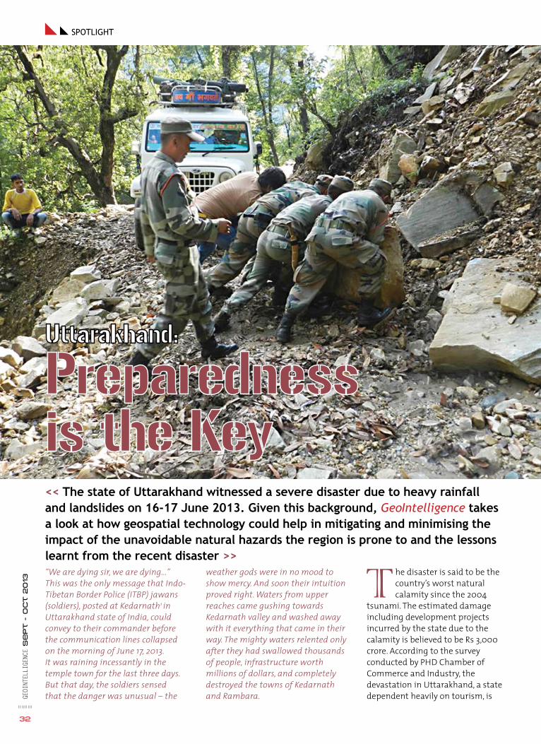
Geoi
ntel
liGe
nce
se
pt -
oct 2
013
32
spotlight
<< The state of Uttarakhand witnessed a severe disaster due to heavy rainfall and landslides on 16-17 June 2013. Given this background, GeoIntelligence takes a look at how geospatial technology could help in mitigating and minimising the impact of the unavoidable natural hazards the region is prone to and the lessons learnt from the recent disaster >>“We are dying sir, we are dying...” This was the only message that Indo-Tibetan Border Police (ITBP) jawans (soldiers), posted at Kedarnath1 in Uttarakhand state of India, could convey to their commander before the communication lines collapsed on the morning of June 17, 2013. It was raining incessantly in the temple town for the last three days. But that day, the soldiers sensed that the danger was unusual – the
weather gods were in no mood to show mercy. And soon their intuition proved right. Waters from upper reaches came gushing towards Kedarnath valley and washed away with it everything that came in their way. The mighty waters relented only after they had swallowed thousands of people, infrastructure worth millions of dollars, and completely destroyed the towns of Kedarnath and Rambara.
The disaster is said to be the country’s worst natural calamity since the 2004
tsunami. The estimated damage including development projects incurred by the state due to the calamity is believed to be Rs 3,000 crore. According to the survey conducted by PHD Chamber of Commerce and Industry, the devastation in Uttarakhand, a state dependent heavily on tourism, is

33
Geoi
ntel
liGe
nce
se
pt -
oct 2
013
expected to cause revenue loss of Rs 12,000 crore to the state’s tourism industry in the current fiscal, that is, about 11 per cent of Uttarakhand’s Gross State Domestic Product (GSDP).
While nature will continue to have its own way, the best that man can do is to learn to predict, prepare or mitigate natural hazards and devise ways to live in harmony with nature.
Natural Hazard Risk Management
Typically, natural hazard risk management plan involves the following:
» Risk assessment – analysis and evaluation of the type of risk, identification of location and its potential impact on the society
» Risk control – preventive and curative measures to be taken to reduce the impact of natural hazards
» Disaster and contingency planning – in case a disaster strikes, how should it be managed
» Disaster analysis and evaluation – post-disaster, assessment of damage (financial, infrastructure/ topographic) and the lessons learnt from the calamity
Risk Assessment
Risk assessment methodologies help planners identify the type of risks associated with a particular area – be it landslides, floods, earthquakes or fires. In order to better the understanding of the type of disasters that can hit an area, hazard mapping of the area is undertaken. The maps generally show risk zones as well as disaster impact zones. These could include landslide hazard maps, flood zone maps, seismic zone maps, forest fire risk maps, etc.
Only after the threats are identified and risk assessed,
Security forces carrying out the rescue act

34
Geoi
ntel
liGe
nce
se
pt -
oct 2
013
inteRview: Ari hulkkonen
can the administration plan any infrastructure, appropriate economic activity, settlement planning for the area.
the Uttarakhand scenario
The recent disaster in the state was caused by rains resulting in floods and landslides. Geological Survey of India (GSI), in its ‘Preliminary study Note on Natural Disaster at Uttarakhand,’ observed that very heavy and incessant rains from 15 to 17 June 2013 caused exceptionally high rise in the river discharges. “The rise in the river level was of the order of 5-7m where the valley was wide and 10–12m where the valley was narrow,” the report said, adding, “The gush of water running down from Kedarnath and Rambara areas brought mammoth sediment load which consisted of huge rock boulders with the longest diameter ranging from 3-10m. The enormous volume of water induced toe erosion along all the river valleys which in turn
triggered landslides at a number of places.” The National Institute of Disaster Management (NIDM), in its report on the Uttarakhand disaster, further elaborates the point, “The Alaknanda and its tributary Mandakini occupied their flood ways and started flowing along the old courses where human habitation had come up with passage of time (when the river had abandoned this course and shifted its path to the east side). Thus, the furious river destroyed the buildings and other infrastructure that came in its way.”
Experts say that with the present level of technology available within the country, it is not possible to predict the devastation of this magnitude. But was it really impossible to see that the state was sitting on a time-bomb, waiting to explode?
NIDM in its reports states, “Geologically, the rocks in this area are found highly deformed,
degraded and dissected by structural discontinuities and drainages. Seismo-tectonically, the area is traversed by several lineaments, faults and thrusts, which are considered to be geodynamically active. The area had suffered an earthquake on 29 March 1999 (M-6.8) which caused loosening of rock masses, ground cracks and landslides etc.” Talking about the Kedarnath Valley, Uttarakhand Space Application Centre (USAC) in its report about the recent disaster in Kedarnath Dham and Mandakini Valley, mentions, “The region is seismically and ecologically very sensitive and fragile and even small disturbances (natural or anthropogenic) trigger changes that rapidly assume the dimension of a disaster.”
It is unlikely that the government was unaware about the region’s vulnerably to natural hazards, given the fact that it had identified landslide, soil erosion and glacier recession as some
An aerial view of flood-ravaged Rudraprayag in Uttarakhand

35
Geoi
ntel
liGe
nce
Se
pt -
oct 2
013
of the major challenges before the administration in its report, State Action Plan on Climate Change, published in 2012. Also, its Disaster Mitigation and Management Centre at Dehradun (an autonomous institute under the aegis of state government’s Department of Disaster Management, it is responsible for formulating appropriate policies and strengthening the capabilities of both the administration and local population to cope up with all aspects of disaster management) carries out a number of studies to assess the disaster vulnerability of the state. For example, it has completed landslide and environmental risk assessment of Nainital and Mussoorie cities, vulnerability of the building stock of Mussoorie, Nainital, Bageshwar, Haridwar, Dehradun, Rudraprayag, Pauri, Srinagar and Joshimath have been assessed.
There are also several organisations which are carrying out extensive studies in hazard assessment and management, for example, GSI, Central Road Research Institute (CRRI), Wadia Institute of Himalayan Geology (WIHG), DRDO, IIT Roorkee, National Remote Sensing Centre (NRSC), etc. They share their reports and findings periodically with the government. But clearly in this case, adequate precautionary measures were absent and construction activity on the hills was unchecked.
Risk Control
There are various tools available for risk mitigation:
General observation: Nature has its own way of conveying threats. The need is to educate people about the possible cues that nature provides before any impending disaster. Some of the landslide warning signs to look for are – walls or stairs begin to pull away from the building; slowly developing, widening cracks start appearing on the ground or on the streets; water
breaks through the ground surface at new locations, etc. Similarly, the rising level of rivers due to continuous and relentless rains can be an indication of possible floods. Animals are said to be blessed with the capability to anticipate these dangers. The unusual anxiety and distress among cattle, dogs or other domestic animals can be a sign of an impending danger.
Restricting development: “Landuse planning is one of the most effective and economical ways to reduce losses by avoiding the hazard and minimising the risk,” says Dr Surya Parkash, in his book, Training Module on Comprehensive Landslides Risk Management. The author further says, “This is accomplished by removing or converting existing development or discouraging or regulating new development in unstable areas.”
Protecting existing structures: Relocation is not always possible and hence there is a need to strengthen the existing structures
against disasters. Slope-stabilisation methods are usually adopted for prevention against landslides.
Monitoring and warning systems: Early warning systems are being used by several countries for real-time automated monitoring of natural disasters. These include monitoring the movements, development of stresses, and pore pressures or hydrostatic pressures continuously and transmission
<< location intelligence is the most sought-after
information whenever a calamity strikes.
geospatial technology aids in search and relief
operations. it can also be used for mobilising
resources during disaster period >>
Uttarakhand
Rudraprayag
Worst Affected District of the State

of instrumental generated data at regular time intervals.2 For example, post tsunami 2004, the Indian government set up an Indian Tsunami Early Warning Centre (ITEWC) at Indian National Centre for Ocean Information Sciences (INCOIS - ESSO), Hyderabad. The centre is one of the best systems in the world today, and is not only serving as the primary source of tsunami advisories for India but also as the regional tsunami advisory service provider for the entire Indian Ocean region.
Did Uttarakhand government ignore all warnings?
Unplanned development work: Environmentalists blame the
unplanned and unabated development work, esp., hydel-power projects for the present crisis in the state. According to reports, 45 hydropower projects with a total capacity of more than 3,000 MW are operational in the state, and around 200 big and small projects are proposed or under way. In the Alaknanda-Bhagirathi basin alone, nearly 69 hydropower projects with a total capacity of about 9,000 MW are underway. The implementation of these projects is estimated to affect about 65 per cent of Alaknanda and 80 per cent of Bhagirathi river.
In its report on hydropower development, published in 2009, the Comptroller and Auditor
General (CAG) had pointed out the lack of measures being planned or designed in any hydel project being carried out in the state, to cope with the risk of flash floods. Voicing its concern over deforestation and the ongoing and proposed hydro-power projects, CAG had said that the projects are weakening the mountains.
IMD warning: India Meteorological Department (IMD) maintained that it did warn the state government about the heavy rainfall in the region 48 hours in advance. State Chief Minister (CM) Vijay Bahuguna is reported to have said that the forecasts were not actionable as the warning was not clear. “It only
36
Geoi
ntel
liGe
nce
se
pt -
oct 2
013
How India Carried Out One of the World’s Biggest and Quickest Search and Rescue Operations?
The Indian state of Uttarakhand recently witnessed one of its worst
natural disasters. The floods accompanied by landslides killed hundreds of people and injured thousands. “The magnitude of the disaster was so huge that in the first phase, we were not even sure about what had actually happened in the region – was it just flash floods or something more,” said Keshav Kumar, Deputy Commandant (Administration), National Disaster Response Force (NDRF). (NDRF is a disaster response agency under National Disaster Management Authority which is an apex national body for disaster management and is entrusted with the responsibility of laying down policies, plans and guidelines for disaster management.) NDRF had moved its teams to the state by June 17 itself but was unable to proceed to the devastated zones due to collapsed roads.
People were scattered and stranded all over the places –Pindari Glacier, Sunder Dunga Glacier in Kumaon
region, Arva Tal on Gangotri–Mana axis etc. The challenge for the rescuers was not only to identify areas where the survivors were but also to reach to them quickly, provide food and medication, evacuate them and take them to safer zones. And this had to be done in a weather which prevented safe flying and when there was absolutely no road connectivity. Several of the stranded people had also incurred injures due to the disaster, and required immediate medical aid. “Initially, there were too many hiccups. Rains weren’t stopping, the ground was fragile, roads were completely damaged and the telephone lines weren’t working. It was a challenge to operate in those conditions,” explains Comdt GS Chauhan, who was responsible for overseeing ITBP’s operation in the state. “In fact, the only way we could communicate with each other was with our HF sets, which require frequent charging but there was no electricity at that time. The jawans (soldiers) would call, provide us the necessary info and switch off their sets. Things, however, improved as the days progressed,” he added. Being stationed in the region, ITBP was the first ground responder to the calamity. Given the magnitude
of the disaster, it was impossible for the administration to operate without the help of Indian Armed Forces. Indian Air Force (IAF), Indian Army and in some cases, even Indian Navy, rendered their services to the SAR operations. Border Roads Organisation (BRO) which builds and maintains roads in mountainous regions, diverted its resources – both personnel and equipment from other projects - for clearing roads and rescuing the affected.
How was information about stranded people collected?
Information about the stranded people was collected through a number of sources, the chief among them being helplines. Phone numbers were flashed across the country and people were asked to contact on these numbers with information about the survivors or their whereabouts. As phone became the chief source of gathering location intelligence about survivors, the administration worked overtime to ensure restoration of telecommunication facilities. Also, the rescuers were provided with satellite phones for unperturbed services.

37
Geoi
ntel
liGe
nce
Se
pt -
oct 2
013
Helicopter recce and UAVs were also put into service to gain information about survivors.
The Government of Uttarakhand provided the latest information on rescue and relief measures in the state on its website www.uk.gov.in, while the Indian Army launched www.suryahopes.in. The website gave minute-to-minute update on army operations across the state, location wise data of people stranded at various places, list of rescued persons, helpline numbers, latest news about flood victims and provided links to Uttarakhand government website and Google sites giving information on flood affected people. Google had introduced an online Crisis Map for Uttarakhand which provided information on rescued people, roads closed and cleared areas, people stranded, relief camps, medical centres and so on. It had also launched its webapp, Person Finder, which helped people search and post information about missing people.
The jawans also physically screened several areas to rule out the presence of survivors in inaccessible areas.
The work ahead
Unlike others, BRO’s work does not end with the successful completion of SAR operation. It now faces the herculean task of rebuilding the roads and reconnecting the region with the rest of the country. The challenges are many. For example, the devastation has rendered several zones which hosted roads earlier unsafe, and so on. A massive road rehabilitation programme has been taken up by BRO in the entire state.
The disaster will be remembered in history not only for its extent of devastation but also for the manner in which the search and rescue operation were carried out. It was the efforts of all the agencies involved in the rescue mission - state government, Union Ministry of Home affairs, NDMA, BRO, ITBP, Indian Armed Forces, NDRF, and Union Ministry of Road & Surface Transport - that ensured speedy evacuation, both by air and land, of stranded pilgrims and citizens.
said there would be heavy rains and snowfall in the upper ridges,” he is reported to have said.
However, experts say that whenever an alert of heavy rainfall is issued, it does involve the possibility of cloudbursts. So the question is that despite IMD issuing a timely warning, why did the administration not swing into action? Possibly, because the administration is not well-versed with the terminology used in the warning. But can a person trained in disaster management afford to do so?
As per the Disaster Managment Act, every state is required to constitute its State Disaster
Management Authority (SDMA) headed by a CM and eight other members. The SDMA is responsible for taking preparedness measures and building response capacity as per their vulnerability to various measures. The CAG report 2013 on disaster preparedness in India found that even though the SDMA was constituted in October 2007, it had not formulated any rules, regulations, policies, and/or guidelines. The audit found that no plan was prepared in the state for early warning and the communication system was also inadequate. The CM is reported to have accepted the fact that the state doesn’t meet the norms prescribed by NDMA.
Disaster and Contingency planning
Since natural hazards are bound to occur, it is important to have contingency plans. What to do when a disaster strikes, how much area will it affect, what are the areas where casualties would be high/ people can get trapped, and which routes to be used for evacuation purposes? Geospatial technology is greatly used for obtaining these answers.
Location intelligence is the most sought-after information whenever a calamity strikes. The technology aids in search and relief operations. It can also be used for mobilising resources during disaster period.
Army personnel busy in rescue operations in Pindari glacier in Uttarakhand

post-disaster Analysis and evaluation
Post-disaster, preparing database related to relief and rehabilitation work, and assessing the damage village/ district wise are the major tasks before any government. Here too, geospatial technology plays an important role. “The technology can be used for damage assessment (settlement, road/ infrastructure/ industry, agriculture), topographical change, geomorphological change, land use change, glacier health, snow cover change (if any), river dynamics and drainage network change,” explains Dr P.K.Champati Ray, Head, Geosciences and Geohazards Department and Course Director, Natural Hazards and Disaster Risk Management (NHDRM), Indian Institute of Remote Sensing. He adds, “New vulnerable slope mapping, new landslide hazard zonation should be attempted now
with comprehensive risk assessment of areas where more than 10 lives or Rs 10 lakh are at risk, something similar to EMDAT guidelines.”
Uttarakhand scenario
The report released by USAC helped understand the real reason behind the floods and allayed stories wherein glacier melting was blamed for the disaster. The organisation has already carried out various analyses like optimal alternate route (track route and motor route) to reach the Kedarnath temple, rapid damage estimation of Mandakini valley, snow mapping and glacier retreat of Chorabari Glacier system, plan for control of debris flow and avalanche for Badrinath Dham, etc.
GSI has already carried out geoscientific studies in the affected areas of Uttarakhand. This study was important to help suggest/
delineate suitable and safe sites for relocation/ rehabilitation of 270 odd villages / human settlements that were worst affected by the disaster and to assist BRO, state PWD and or other central/ state agencies in identifying optimum alignment of roads which could be more stable and less prone to landslide hazards.
Lessons Learnt
Risk assessment a must: “Comprehensive risk assessment should be done for all critical areas, monitoring network including observatory and 24X7X365 communication network should be established,” said Dr Champati Ray, adding, “Investment in science and geoinformatics, both in terms of manpower and facility, is required. Regulatory framework and disaster management mechanism should be in place.”
38
Geoi
ntel
liGe
nce
se
pt -
oct 2
013
Image courtesy: USAC
Pre PostPre and post satellite image of Kedarnath valley

39
Geoi
ntel
liGe
nce
Se
pt -
oct 2
013
DISASTER IMPACT
• All 13 districts of Uttarakhand affected including 4200 villages
• More than one lakh people rescued
• About 600 people dead (the number is likely to increase as the debris is cleared)
• 4,473 people injured
• 5,526 people missing
• Estimated damage including development projects incurred is about Rs 3,000 crore
Communication: There is a need to ensure that warnings reach the locals who are likely to get affected by the disaster. In Uttarakhand, for example, despite the IMD issuing warnings well in advance, the government did not issue disaster warning until June 16. And despite that, the pilgrimage was not stopped till the bridges finally collapsed the next day.
Education and training: Education and awareness about natural hazards and risk mitigation should be a priority for all - decision makers and the public. The subject needs to be given precedence, for negligence will only result in another disaster.
Setting up early warning systems: The government doesn’t have to look far. The success of tsunami center at Hyderabad is a clear indication of how earning warning systems can help mitigate dangers.
Challenges
Insurance and financial assistance: Codes for construction based on the vulnerability assessment of an area needs not only be clearly defined but also locals need to be encouraged to follow them. This can be done but providing financial assistance to people who follow codes.
Inputs don’t match the requirements: This is one very common problem that experts
say exist with country’s disaster management plans, that is, agencies involved in disaster management rarely get the information they are looking for. Dr Champati Ray suggests, “There should be a comprehensive assessment of requirement and possible inputs to meet such requirement. It should be done before hand and necessary mock drill should be done to assess the requirement and inputs received.”
Sharing of information: While several organisations are involved in studies related to natural hazard management, there is a need to encourage them to share their work. This will prevent duplication of work and efforts. Also, during the disaster, coordination and information sharing is important as many organisations are involved in disaster control.
Making imagery available on time: Remote sensing imagery is the best way to understand the nature of disaster and its impact. This, if provided timely, can be a great aid to rescue workers. Dr M. M. Kimothi, Director, USAC, says, “Today, our country has satellite systems that provide information periodically on a daily basis as well as on the request of a particular region of the country. However, there are no such systems to provide information on hourly basis, which positively will be achieved soon by the agencies.”
Conclusion
The challenge before Uttarakhand today is to rebuild the state, restore the infrastructure and the economic activity, and restore the faith of locals and tourists in it. People do want development but not at the cost of losing their lives/ property. It is important for the state to maintain a healthy balance between development and environmental sustainability. As Lt Gen Anil Chait, Chief of Integrated Defence Staff, Indian Army, puts it, “Unless the mitigation strategies, preparedness are in place, and until there is coordination and cooperation between agencies to evolve a system to ensure that our people can be safe, things will not improve. We will continue to be reactive. And to deal with natural calamity, we have to be pre-emptive, pro-active. In other words, we have to be prepared.”
Prepared not only to deal with the disaster but also to sail through it, as the jawans of ITBP caught at Kedarnath did. Braving all odds, tired and exhausted, the jawans finally managed their way to their base camp. All six of them alive. The weather gods may have been brutally harsh to them, but it could not dampen their spirits. The undying human spirit didn’t let the physical fatigue come in the way of its ultimate instinct – that of the survival.
notes/ References
1: Kedarnath is located in the Himalaya at a height of 3,583 m (11,755 ft) above sea level in the Mandakini valley of Rudraprayag district, Uttarakhand. It is a very popular destination for Hindu pilgrims, being one of the four dhams in the state. The others being Gangotri, Yamunotri and Badrinath.
2. Training Module on Comprehensive Landslides Risk Management
Aditi BhanAsst Editor, [email protected]

nearly 8,500. We had to rely heavily on helicopter operations. Restoring basic amenities to people caught in the nature’s fury was our top priority.
For the benefit of flood-affected people, Indian Army launched a website, www.suryahopes.in. In what way was your initiative different from Uttarakhand Government’s website?
One must understand that the Army was among the first responders to this crisis. Hence, the information available to us was first hand and factual. The information put on the website brought about immense response on our helplines. We were able to connect people as we had boots on ground. The same information was also shared with the state government. But means for the information to travel were affected. The collection and collation of information therefore earnestly started in rear area where communications were surviving. Initially, it took time to fathom and craft out suitable apparatus to bring this information to people. We have
40
Geoi
ntel
liGe
nce
se
pt -
oct 2
013
Establishing contact with people who were stranded must have been a big problem, with all communication disrupted. What systems were put in place to ensure that no one is left behind?
Search and ability to locate was one of the biggest challenges faced by us. In this case, the initial canvas was as wide as 40,000 sq km which had to be reached and searched in the absence of information. Requirement was to grid the complete area, insert soldiers and establish control thereafter. It involved treading every trail and locating those who need help. The real challenge was to find the last survivors amongst the dead, the creeks, crevasses, nallahs and hills.
Weather was another factor which hampered the rescue missions. Meagre electrooptical and thermal means available for the SAR operations were impacted by the weather and rain. Time was at a premium and the requirement of troops was very large. The strength had to be enhanced from 5,000 to
learnt from this experience and would ensure that the next time the Armed Forces are involved in any such operations, the information sharing is effective and resilient.
Even with NDMA, providing aid to civil authority is something which the Army will have to plan for. Does the Army carry out any training in this regard? Is there a need for specialist equipment?
I think the disaster preparedness process is evolving. NDMA is the apex national body for disaster management. There is a need for joint training and we are moving forward in this direction. Disaster prone areas have been identified and specialist equipment as part of disaster brick is proposed to be placed forward for quick and effective response.
It is believed that there was a lack of coordination between various agencies. In retrospect, how could the situation have been handled better? What are your recommendations?
State administration in forward areas was affected on account of calamity, resources, warning systems and communications. Individual agencies had to move up proactively to provide timely relief. There is a need for one task force commander to coordinate all resources including Armed Forces, ITBP, NDRF and other agencies, preferably under the Army. There is thus a need for establishing Unified Operational Emergency Control Centre which could become command and control hub for all responders to regulate and provide single window coordination for rescue agencies to ensure that relief reaches timely to the affected people.
Lt Gen Anil Chait, the then GOC-in-C, Central Command, Indian Army, was overseeing the Search and Rescue operations in Uttarakhand. Lt Gen Chait took over as Chief of Integrated Defence Staff on July 1, 2013.
Lt GEN ANIL ChAIt
Keeping the Faith Alive
inteRview

Geoi
ntel
liGe
nce
se
pt -
oct 2
013
41
events
SEPTEMBER
Naval and Maritime EXPO 2013September 23-27, 2013Cochin Port TrustKerala, Indiawww.namexpo.in
NCT CBRNe AsiaSeptember 24-27, 2013 Kuala LumpurMalaysia www.ib-consultancy.com/events.html?view=event&id=41:nct-cbrne-asia-2013&evr_id=0
Expomil 2013September 26-29, 2013 Romexpo Exposition CenterBucharest, Romaniawww.expomil.ro/home
OCTOBER
GPEC Asia 2013October 2-4, 2013Putrajaya, Malaysiawww.gpecasia.com.my
Pacific 2013 October 7-9, 2013Sydney Convention and Exhibition Centre, Australiawww.pacific2013.com.au/index.html
GEOINT 2013 October 13-16, 2013Tampa Convention CenterTampa, Florida, USAgeoint2013.com
AUSA Annual Meeting &Exposition October 21–23, 2013 Walter E. Washington Convention CenterWashington DC, USAmyeventmarket.com/ausa12/future-ausa-events
Marine Week 2013October 22-25, 2013Bexco, BusanKoreawww.marineweek.org
CCExpoOctober 23-24, 2013HamburgGermanywww.ccexpo.de/en/home
Seoul International Aerospace & Defense ExpoOct 29–Nov 3, 2013 Republic of Koreawww.seoulairshow.com/eng/
NOVEMBER
Defense & Security 2013November 4-7, 2013 IMPACT Expo centerBangkok, Thailandwww.asiandefense.com
Global MilSatCom 2013November 5-7, 2013 London, UKwww.smi-online.co.uk/defence/uk/conference/global-milsatcom
Dubai Airshow 2013November 17-21, 2013 Dubai World Central (DWC)Jebel Ali, DubaiUnited Arab Emirateswww.dubaiairshow.aero
Milipol 2013November 19-23, 2013
Paris Nord VillepinteFrancehttp://en.milipol.com/
International Convention of Autonomous Unmanned Systems and Robotics (AUS&R)November 26-28, 2013Israelhttp://i-hls.com/2013/07/ausr2013/
DECEMBER
I/ITSEC 2013December 2-5, 2013Orlando, Florida, USAhttp://exhibits.iitsec.org/iitsec13/public /MainHall.aspx
Gulf Defense & Aerospace - Kuwait December 10-12, 2013Kuwait International FairKuwaitwww.gulfdefense.com
JANUARY
DGI 2014January 21-23, 2014QEII Conference CentreWestminster, LondonUnited Kingdomwww.wbresearch.com/dgieurope/home.aspx
FEBRUARY
International Armoured VehiclesFebruary 3-6, 2014FIVE, Farnborough, UKwww.internationalarmouredvehicles.com/
Defexpo India February 6-9, 2014Pragati Maidan, New Delhi Indiahttp://defexpoindia.in/#
Singapore Airshow 2014February 11-16, 2014Changi Exhibition CentreSingaporewww.singaporeairshow.com/#&panel1-3

Image Intelligence
Syria’s conflict going global?E ver since the conflict between Syria’s government
(headed by President Bashar Assad) and pro-reform demonstrators took a violent turn in 2011, the United
Nations (UN) has been under constant pressure from the US and its allies for launching military action against Syria. The latest provocation comes after footage emerged of a suspected chemical weapons attack in areas surrounding eastern Damascus. Hundreds of people are reported to have lost their lives in this attack, said to be the deadliest of the conflict so far. While rebels are blaming the Assad government for the assault, the latter has denied these allegations, describing it as a pre-planned attempt by the opposition to tarnish the government’s image. The world has reacted angrily to the news with US and its allies favouring a limited military strike against the government. Even as the world debates about its response to the use of chemical weapons, Russia has been successful in convincing Syria to place its chemical weapons under international control. Reports say that UN has confirmed receiving documents from Syria on joining the chemical weapons convention. Image Courtesy: DigitalGlobe; NBC News; flickr
Probable artillery impact craters in Anandan, a nearby town of Aleppo in Syria
Syria’s Furqlus weapons depot near the city of Homs. The depot is said to be one of thefive permanent locations where President Assad stores chemical weapons
42
Geoi
ntel
liGe
nce
se
pt -
oct 2
013

REGISTER NOW
GEOINT2013.COM
FREE FOR U.S. AND INTERNATIONAL MILITARY & GOVERNMENT
Brought to you by the United States Geospatial Intelligence Foundation
OCTOBER 13-16, 2013 • TAMPA CONVENTION CENTER • TAMPA, FLORIDA
The Largest Intelligence Event of the Year
CONFIRMED SPEAKERS INCLUDE
The Honorable James R. Clapper Jr.Director of National Intelligence (DNI)
Parag KhannaGlobal Strategist, World Traveler, and Author
Ms. Letitia A. LongDirector, National Geospatial- Intelligence Agency (NGA)
Robert ScobleAmerican Blogger, Technical Evangelist, and Author
ADM William H. McRaven, U.S. NavyCommander, U.S. Special Operations Command (USSOCOM)
Dr. David KilcullenAuthor and President & CEO, Caerus Associates
• Hear from leading government, military and technology speakers
• Network and share best practices with other geospatial technology & remote sensing professionals
• Discover hands-on the latest technology, solutions, and services from 200+ exhibitors in 200,000 square feet of exhibit space

Subscribe todaySubscribe todayGET YOUR DIGITAL EDITIONAVAILABLE ON http://goo.gl/ljcXwl
44.indd 1 9/16/2013 8:33:34 PM