issue the spring 2017 summit - wild apricot. some places are impossible to imagine with-out the...
TRANSCRIPT

W A U R I S A : T h e W a s h i n g t o n S t a t e C h a p t e r o f U R I S A
T h e A s s o c i a t i o n f o r G I S P r o f e s s i o n a l s W W W . W A U R I S A . O R G
The
Summit
Also In This Issue:
Trauma in a Pictorial Map 2
Finding Great Trails and Helpful Search & Rescue Applications
5
More is Better—ArcBruTile, a Basemap Add-in for ArcMap
16
Dr. Monica Stephens to Keynote #WAGIS17
17
ISSUE 44
SPRING 2017
N e w s F r o m a n d F o r t h e W a s h i n g t o n G I S C o m m u n i t y
S pring is here. Not sure if you can tell but that was said
with jubilation as we certainly endured a cold and wet
winter. In fact, the National Weather Service in Seattle
reported that it was the wettest winter in Seattle history. As we
begin the slow transition through spring towards summer,
once again the tulips in Skagit County have returned to greet
us along the way. Another annual springtime event that I look
forward to is the annual Washington GIS conference. It’s
shaping up to be one of the best years ever as a large number
of volunteers are busy putting on the final touches.
The Washington GIS conference is the capstone project for
Washington URISA and it takes a huge number contributors to
pull it all together. It has always an amazing forum by and for,
Washington GIS users and I hope you will join us again this
year. In keeping with last year’s conference, Tacoma will again
play host to the gathering. While we normally switch up
locations, we had such an overwhelming positive response to
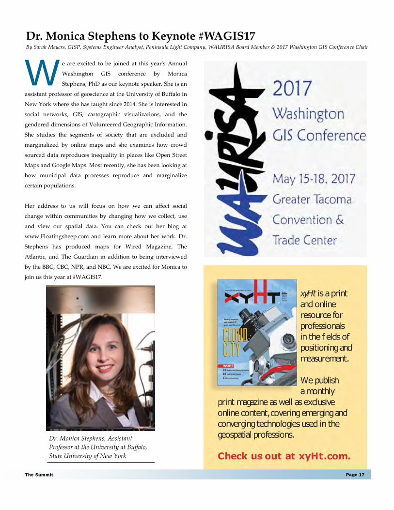
Washington GIS Conference 2017—President’s Message By: Joshua Greenberg, Senior GIS/Remote Sensing Analyst, Skagit County, WAURISA President
hosting last year it in
Tacoma, we decided to
give it another go for
2017. Despite hosting it
in the same location two
years in a row, this year
has some changes to look
forward to.
Some of the highlights
include two full days,
Monday and Tuesday, of
pre-conference workshops with five concurrent tracks. My
biggest complaint is that it is impossible to be in more than
one workshop at a time. In addition, this year will include a
URISA certified trainer flying out from Florida to offer a
popular asset management course as well as having both
(Continued on page 3)
Skagit Valley Tulips—Photo Credit: Joshua Greenberg
Page 2 Issue 44
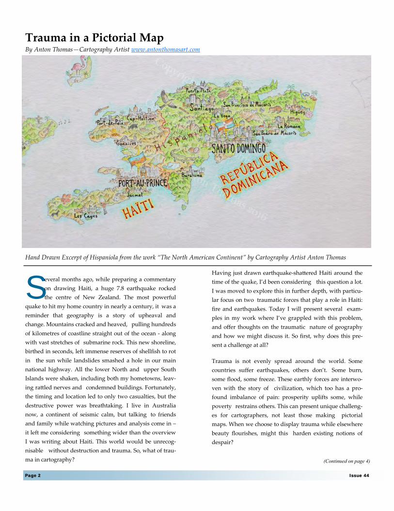
S everal months ago, while preparing a commentary
on drawing Haiti, a huge 7.8 earthquake rocked
the centre of New Zealand. The most powerful
quake to hit my home country in nearly a century, it was a
reminder that geography is a story of upheaval and
change. Mountains cracked and heaved, pulling hundreds
of kilometres of coastline straight out of the ocean - along
with vast stretches of submarine rock. This new shoreline,
birthed in seconds, left immense reserves of shellfish to rot
in the sun while landslides smashed a hole in our main
national highway. All the lower North and upper South
Islands were shaken, including both my hometowns, leav-
ing rattled nerves and condemned buildings. Fortunately,
the timing and location led to only two casualties, but the
destructive power was breathtaking. I live in Australia
now, a continent of seismic calm, but talking to friends
and family while watching pictures and analysis come in –
it left me considering something wider than the overview
I was writing about Haiti. This world would be unrecog-
nisable without destruction and trauma. So, what of trau-
ma in cartography?
Trauma in a Pictorial Map By Anton Thomas—Cartography Artist www.antonthomasart.com
Hand Drawn Excerpt of Hispaniola from the work “The North American Continent” by Cartography Artist Anton Thomas
Having just drawn earthquake-shattered Haiti around the
time of the quake, I’d been considering this question a lot.
I was moved to explore this in further depth, with particu-
lar focus on two traumatic forces that play a role in Haiti:
fire and earthquakes. Today I will present several exam-
ples in my work where I’ve grappled with this problem,
and offer thoughts on the traumatic nature of geography
and how we might discuss it. So first, why does this pre-
sent a challenge at all?
Trauma is not evenly spread around the world. Some
countries suffer earthquakes, others don’t. Some burn,
some flood, some freeze. These earthly forces are interwo-
ven with the story of civilization, which too has a pro-
found imbalance of pain: prosperity uplifts some, while
poverty restrains others. This can present unique challeng-
es for cartographers, not least those making pictorial
maps. When we choose to display trauma while elsewhere
beauty flourishes, might this harden existing notions of
despair?
(Continued on page 4)
Page 3 The Summit
professional trainers and colleagues offering a wide variety
of training opportunities. Other offerings include courses in
drones and UAV’s, working with linear referencing and
geodatabases, practical python, geosimulation and agent
based modelling, among other. Keeping with our goal of
serving the Washington GIS community, the workshops are
offered at prices that are hard to pass up. Workshops and
classes are offered ala carte, so you can sign up for half-day
sessions in any combination to fill two days as suits your
needs. Be sure to check out all the classes and schedules here:
https://wagis2017.sched.com/
After workshops Monday & Tuesday, the conference will
officially be kicked off Wednesday, May 17th by keynote
speaker Dr. Monica Stephens. Dr. Stephens’ research
integrates methodologies in GIS with social network analysis
(SNA) and Big Data. You can read more about her work and
her upcoming presentation later in this issue. An additional
perk this year is that presenters were able to register for the
conference at half price. This is a substantial increase in
reward over our past years and we hope demonstrates
WAURISA’s desire to reward members who actively
contribute.
Another highlight this year is that our ever popular social
(Continued from page 1)
Washington GIS 2017 Conference—President’s Message
UPCOMING SUMMIT
DEADLINES
Submit articles to The Summit for publication by:
Summer Issue Fall Issue
6/15/2017 9/15/2017 First Draft (optional)
6/22/2017 9/22/2017 Final Draft
will be at the Washington State History Museum. Conference
participants will be able to explore the exhibits after hours
while discussing their most pressing GIS issues over a drink.
In closing, this will be my last conference as WAURISA
President. My term comes to an end on the last day of the
conference. It is a bitter sweet time since I enjoyed working
with and meeting so many amazing GIS people from around
the state and beyond. I look forward to seeing you at the
conference as we share, celebrate and learn about all things
GIS. Thank you for the opportunity to serve as WAURISA
President and I look forward to continue working with all of
you into the future.
Sincerely,
Joshua Greenberg
Page 4 Issue 44
Focusing on the beauty of the world is compelling, not
merely because we want maps and art to be beautiful, but
because cartography is critical in how the world is viewed.
Acknowledging trauma can deepen shadows that already
depress places and people that deserve the dignity of beau-
ty. But life is not utopia. Rather than decorate the world,
I’d like to engage with it. First and foremost a cartographer
relies on data, and data has a way of encouraging complexi-
ty.
In creating pictorial maps, the temptation to focus solely on
idealistic content is strong. However, beauty is not a matter
of good or bad. Truth has a beauty that tells a more interest-
ing and relatable story than any utopia. Even in regions
with far more wealth than Haiti I have irritated locals (who
are justified in feeling this way) - by drawing smog-
belching factories, open-pit mines and grim oil refineries.
In parts of Mexico ravaged by cartels I’ve drawn assault
rifles and opium poppies. Prince William Sound in Alaska
has the sinking Exxon Valdez spilling oil through its wa-
ters. In Bhopal, India, I left the cityscape entirely without
colour to emphasise the toxic legacy of the Union Carbide
disaster. These are reminders of real pain, and I don’t
blame residents of such areas if they dislike my depiction.
No one wants their home defined by trauma.
After all, we connect with our land through much more
than a lens of despair and disaster. Yet we’re also unlikely
to view it as a sunny brochure of attractions and regional
(Continued from page 2)
iconography. Some places are impossible to imagine with-
out the changes brought on from recent trauma. Port-au-
Prince, Haiti is one of those places. To draw this shattered
city I settled on a method I used on my first major project:
South Asia/Australasia.
To draw this shattered city, I settled on a method I used back
in my first major project: South Asia/Australasia.
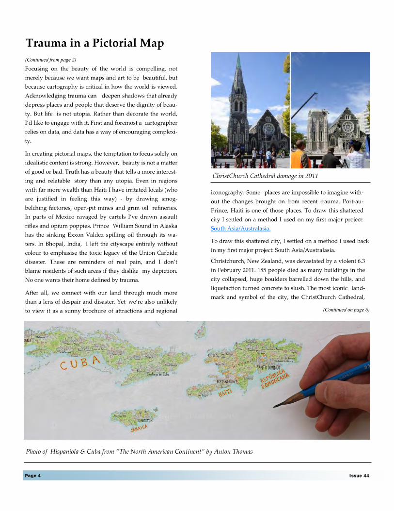
Christchurch, New Zealand, was devastated by a violent 6.3
in February 2011. 185 people died as many buildings in the
city collapsed, huge boulders barrelled down the hills, and
liquefaction turned concrete to slush. The most iconic land-
mark and symbol of the city, the ChristChurch Cathedral,
(Continued on page 6)
Trauma in a Pictorial Map
Photo of Hispaniola & Cuba from “The North American Continent” by Anton Thomas
ChristChurch Cathedral damage in 2011
Page 5 The Summit
Finding Great Trails and Helpful Search & Rescue Applications By: Miranda Brewer, GISP, GIS Specialist, King County Sheriff’s Office/RCECC
A s the saying goes, April showers bring May flowers.
The spring months bring something else too, a great
opportunity to go hiking! You’re less likely to en-
counter snow, and in many places, it’s still rainy enough to
keep the crowds away and the parking lot accessible. It’s also
long before wildland fire season. When it comes to ensuring a
successful hike, a little preparation can go a long way. I’m go-
ing to cover a few online resources to help you find a suitable
trail, how to stay safe while hiking, and how to be found should
an emergency occur
Washington State is home to many trails of various lengths and
levels of difficulty. In King County alone, there are 175 miles of
regional trails and 215 miles of backcountry trails. They are
available for viewing in TrailFinder, an easy to use mobile-
friendly app. Just click or tap on a trail to determine its length,
surface type, and which areas of the county it passes through.
Pair TrailFinder with the Washington Trails Association hike
finder map and you will have a good idea of what to expect on
most trails in the county.
(http://gismaps.kingcounty.gov/TrailFinder/)
While not quite as interactive, the National Parks Service has a
map of Olympic National Park that shows the major trails,
camp sites, and peaks (https://www.nps.gov/olym/
planyourvisit/maps.htm). This map is good for general plan-
ning purposes, but a more detailed topographic map is recom-
mended for hiking and are available from a variety of public
and private sources. The U.S. Department of Agriculture Forest
Service’s geodata clearinghouse offers a series of quadrangle
maps called FSTopo. These are freely available as geo-enabled
PDFs or GeoTiffs at https://data.fs.usda.gov/geodata/
rastergateway/states-regions/states.php. So whether you’re
looking to hike near Mt. St. Helens in the Gifford Pinchot Na-
tional Forest or head east of the Cascades to the Colville Nation-
al Forest, there is a good chance you will find the map you
need. Pair these with the Avenza Maps App on your
smartphone and you’ve got a backcountry GPS unit ready to
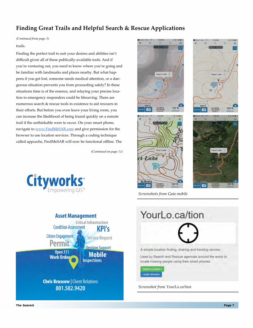
go! Another great resource for topographic maps is Gaia GPS.
This application isn’t free, but it might be worth the cost if
you’re an avid hiker and are looking for a reliable alternative to
paper maps or guidebooks. Download the area you are interest-
ed in prior to hitting the trail. You will find a wide variety of
detailed topographic and street maps. There are options for
track routing, navigation, access to way points, and more.
Google Maps also offers offline maps. You can download areas
and utilize them offline if you know you will be somewhere
where the Internet is sluggish or you do not have a data connec-
tion. Find more detailed instructions at https://
support.google.com/maps/answer/6291838. The quality for hik-
ing might be limited to how much data Google knows about the
(Continued on page 7)
Page 6 Issue 44
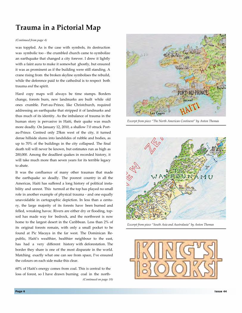
was toppled. As is the case with symbols, its destruction
was symbolic too - the crumbled church came to symbolize
an earthquake that changed a city forever. I drew it lightly
with a faint aura to make it somewhat ghostly, but ensured
it was as prominent as if the building were still standing. A
crane rising from the broken skyline symbolises the rebuild,
while the deference paid to the cathedral is to respect both
trauma and the spirit.
Hard copy maps will always be time stamps. Borders
change, forests burn, new landmarks are built while old
ones crumble. Port-au-Prince, like Christchurch, required
addressing an earthquake that stripped it of landmarks and
thus much of its identity. As the imbalance of trauma in the
human story is pervasive in Haiti, their quake was much
more deadly. On January 12, 2010, a shallow 7.0 struck Port-
au-Prince. Centred only 25km west of the city, it turned
dense hillside slums into landslides of rubble and bodies, as
up to 70% of the buildings in the city collapsed. The final
death toll will never be known, but estimates run as high as
200,000. Among the deadliest quakes in recorded history, it
will take much more than seven years for its terrible legacy
to abate.
It was the confluence of many other traumas that made
the earthquake so deadly. The poorest country in all the
Americas, Haiti has suffered a long history of political insta-
bility and unrest. This turmoil at the top has played no small
role in another example of physical trauma - and one equally
unavoidable in cartographic depiction. In less than a centu-
ry, the large majority of its forests have been burned and
felled, wreaking havoc. Rivers are either dry or flooding, top-
soil has made way for bedrock, and the northwest is now
home to the largest desert in the Caribbean. Less than 2% of
its original forests remain, with only a small pocket to be
found at Pic Macaya in the far west. The Dominican Re-
public, Haiti’s wealthier, healthier neighbour to the east,
has had a very different history with deforestation. The
border they share is one of the most disparate in the world.
Matching exactly what one can see from space, I’ve ensured
the colours on each side make this clear.
60% of Haiti's energy comes from coal. This is central to the
loss of forest, so I have drawn burning coal in the north-
(Continued from page 4)
(Continued on page 10)
Trauma in a Pictorial Map
Excerpt from piece “South Asia and Australasia” by Anton Thomas
Excerpt from piece “The North American Continent” by Anton Thomas
Page 7 The Summit
trails.
Finding the perfect trail to suit your desires and abilities isn’t
difficult given all of these publically-available tools. And if
you’re venturing out, you need to know where you’re going and
be familiar with landmarks and places nearby. But what hap-
pens if you get lost, someone needs medical attention, or a dan-
gerous situation prevents you from proceeding safely? In these
situations time is of the essence, and relaying your precise loca-
tion to emergency responders could be lifesaving. There are
numerous search & rescue tools in existence to aid rescuers in
their efforts. But before you even leave your living room, you
can increase the likelihood of being found quickly on a remote
trail if the unthinkable were to occur. On your smart phone,
navigate to www.FindMeSAR.com and give permission for the
browser to use location services. Through a coding technique
called appcache, FindMeSAR will now be functional offline. The
(Continued from page 5)
(Continued on page 11)
Finding Great Trails and Helpful Search & Rescue Applications
Screenshots from Gaia mobile
Screenshot from YourLo.ca/tion

Page 8 Issue 44
Partial completion of “The North American Continent” by Anton Thomas
west at the site of this largest Caribbean desert. Fire in
art evokes motion, and wherever phenomena are of a
fiery nature their inclusion can be highly effective in a
map. From erupting volcanoes to gas flares on oil refineries,
fire always makes for visceral content. Even satellite pictures
of the Earth at night tell us profound things about human
geography via a network of blazing lights.
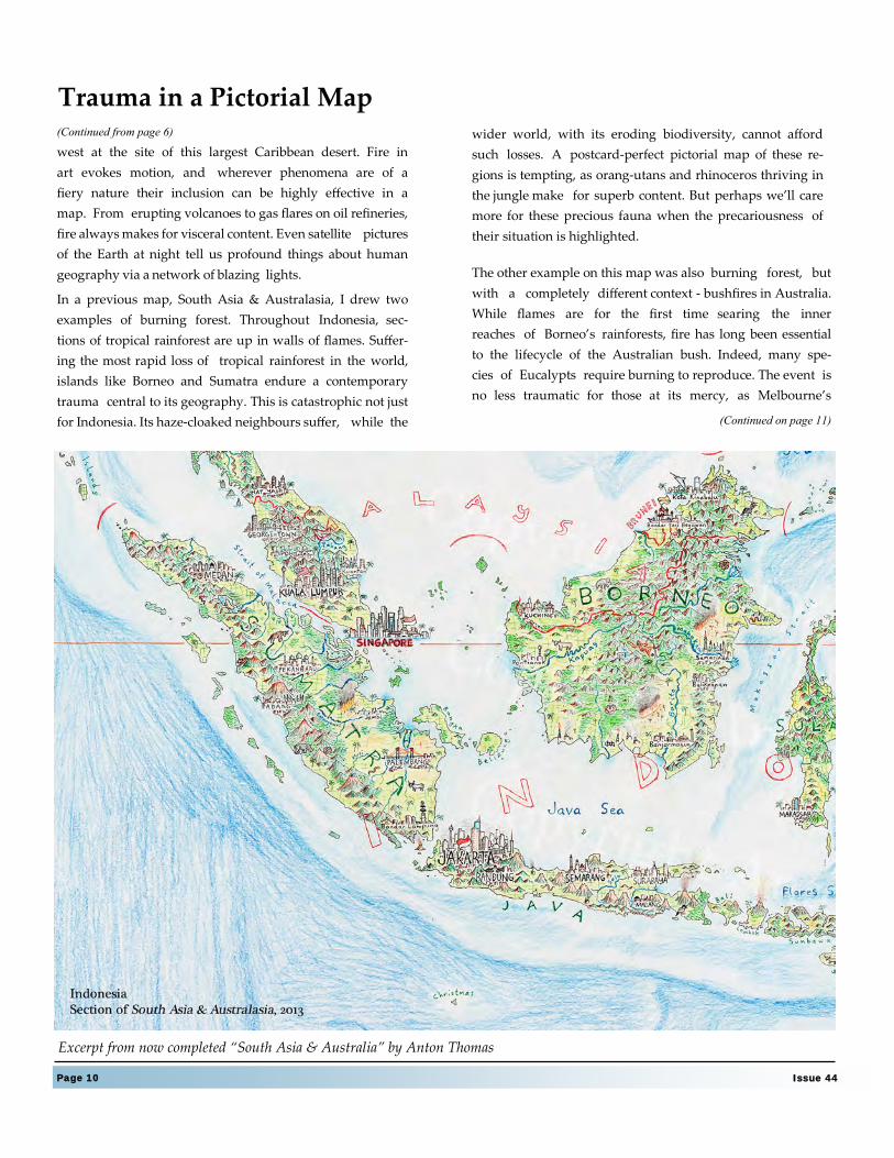
In a previous map, South Asia & Australasia, I drew two
examples of burning forest. Throughout Indonesia, sec-
tions of tropical rainforest are up in walls of flames. Suffer-
ing the most rapid loss of tropical rainforest in the world,
islands like Borneo and Sumatra endure a contemporary
trauma central to its geography. This is catastrophic not just
for Indonesia. Its haze-cloaked neighbours suffer, while the
(Continued from page 6)
Page 10 Issue 44
Trauma in a Pictorial Map
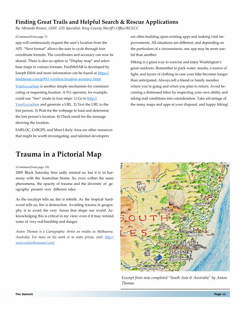
Excerpt from now completed “South Asia & Australia” by Anton Thomas
wider world, with its eroding biodiversity, cannot afford
such losses. A postcard-perfect pictorial map of these re-
gions is tempting, as orang-utans and rhinoceros thriving in
the jungle make for superb content. But perhaps we’ll care
more for these precious fauna when the precariousness of
their situation is highlighted.
The other example on this map was also burning forest, but
with a completely different context - bushfires in Australia.
While flames are for the first time searing the inner
reaches of Borneo’s rainforests, fire has long been essential
to the lifecycle of the Australian bush. Indeed, many spe-
cies of Eucalypts require burning to reproduce. The event is
no less traumatic for those at its mercy, as Melbourne’s
(Continued on page 11)
Page 11 The Summit
Finding Great Trails and Helpful Search & Rescue Applications By: Miranda Brewer, GISP, GIS Specialist, King County Sheriff’s Office/RCECC
app will continuously request the user’s location from the
API. “Next format” allows the user to cycle through four
coordinate formats. The coordinates and accuracy can now be
shared. There is also an option to “Display map” and select
base maps in various formats. FindMeSAR is developed by
Joseph Elfelt and more information can be found at https://
findmesar.com/p/911-wireless-location-accuracy.html.
YourLo.ca/tion is another simple mechanism for communi-
cating or requesting location. A 911 operator, for example,
could use “free” mode in four steps: 1) Go to http://
YourLo.ca/tion and generate a URL. 2) Text the URL to the
lost person. 3) Wait for the webpage to load and determine
the lost person’s location. 4) Check email for the message
showing the location.
SARLOC, CellGPS, and Most Likely Area are other resources
that might be worth investigating, and talented developers
(Continued from page 7) are often building upon existing apps and making vital im-
provements. All situations are different, and depending on
the particulars of a circumstance, one app may be more use-
ful than another.
Hiking is a great way to exercise and enjoy Washington’s
great outdoors. Remember to pack water, snacks, a source of
light, and layers of clothing in case your hike becomes longer
than anticipated. Always tell a friend or family member
where you’re going and when you plan to return. Avoid be-
coming a distressed hiker by respecting your own ability and
taking trail conditions into consideration. Take advantage of
the many maps and apps at your disposal, and happy hiking!
2009 Black Saturday fires sadly remind us, but it is in har-
mony with the Australian biome. So, even within the same
phenomena, the opacity of trauma and the diversity of ge-
ography present very different tales.
As the eucalypt tells us, fire is rebirth. As the tropical hard-
wood tells us, fire is destruction. Avoiding trauma in geogra-
phy is to avoid the very forces that shape our world. Ac-
knowledging this is critical in my view; even if it may remind
some of very real hardship and danger.
Anton Thomas is a Cartographic Artist an resides in Melbourne,
Australia. For more on his work or to order prints, visit: http://
www.antonthomasart.com/
(Continued from page 10)
Trauma in a Pictorial Map
Excerpt from now completed “South Asia & Australia” by Anton
Thomas

Page 13 The Summit
Esri's geographic information system (GIS) software gives you the power to think and plan geographically. GIS is used in more than 350,000 organizations world-
wide. It helps cities, governments, universities, and Fortune 500 companies save money, lives and our environment. Whether transporting ethanol or studying
landslides, these organizations use GIS to collect, manage, and analyze geographic
information, which helps them see relationships, patterns, and trends. They can then solve problems and make better decisions because they are looking at their data in a way that is quickly understood and easily shared.
Cityworks® - Empowering GIS® for Public Asset Management. Since 1986, Azteca Systems Inc. has been providing innovative GIS-centric management soft-ware to public agencies that own and care for infrastructure and property. Built
exclusively on Esri’s ArcGIS technology, Cityworks® is a powerful, scalable, and affordable platform for asset management, permitting, licensing and more. Time-tested and proven technology, Cityworks is Empowering GIS® at more than 500
user sites around the world.
Electronic Data Solutions® (Elecdata®) provides exceptional products and ser-
vices for spatially enabled field data collection and environmental monitoring solutions. Along with our specialization in mobilizing field crews, we also offer the necessary back office applications with professional GIS services for data
management and reporting by leveraging advances in web, cloud, and enterprise technologies. We can give you expert guidance on Trimble mapping and imaging systems, Esri GIS software, Laser Technology rangefinders, Juniper Systems field computers, and various water monitoring instrumentation. We have rental
equipment with a repair center for Trimble mapping hardware. Our professional services also include premium technical support, training, ArcGIS Online and Collector app services and UAS (Unmanned Aircraft Systems) products and
services. Visit us at www.elecdata.com
thanks the following sponsors
for their generous support:
The King County GIS Center provides quality service and exceptional value for our clients with one of the most capable GIS organization in the Pacific North-west. Unlike most consultants, our professional staff members are not merely
theoreticians, but practicing users of the types of GIS solutions government and business require. Why do we offer our services to outside customers? We have a long-term interest in the success of GIS throughout the region. We know that
our success depends on satisfied clients and we are committed to delivering quality GIS business solutions that provide value for our customers. Whether you need consulting, programming, data, mapping, or GIS training - -
Let KCGIS help you put GIS to work!
Page 14 Issue 44
The Urban Studies Program offers a Master of Science in Geospatial Technolo-gies degree. Admission is open during autumn quarter only and will be com-
prised of a 20 student cohort. The degree will provide advanced training in GIS, training students to use and apply geospatial hardware, software, and data in urban and environmental planning scenarios. It will also prepare students to
become leaders in the management and utilization of geospatial technologies within the job market -- public, private, and not-for-profit sectors. It will also offer training in the development and deployment of location-based mobile appli-
cations and management of web-based geospatial data. This program will main-tain a theoretical/critical focus on the application of these technologies to urban and environmental problem solving.
Pictometry integrations give GIS professionals the ability to apply highly accurate, real-world visual context to property-centric, land-based features within pro-
grams such as the Esri® ArcGIS solutions suite. Activities traditionally requiring field visits can be performed directly from a tablet, desktop or handheld device, utilizing the power of Pictometry images and solutions. Enjoy a seamless blend of
GIS and real-world visualization in a single, productive work-flow. www.pictometry.com
West Safety Services is North America’s leading provider of 9-1-1 technology solutions. Backed by over 36 years of world-class network engineering focused on the needs of public safety, West manages the entire emergency response
continuum through data management, reliable networks and a deep understand-ing of public and personal safety emergency response protocols. We continue to develop ground-breaking NG9-1-1 solutions. Our seamless, reliable, redundant,
end-to-end infrastructure enables responding agencies to locate, route, transport and deliver emergency communications to help save lives. West continues to break new ground, providing users of both traditional and emerging technology with high-quality, reliable access to 9-1-1.
At Latitude Geographics, we believe that geographic information over the web can empower people to make better decisions that affect their lives, society, and the world around us. We channel our energy into developing Geocortex soft-
ware and providing related services. We help hundreds of customers and part-ners around the world maximize their success with Esri web-based mapping technology. Esri is the world's leading GIS platform. Behind the scenes, we be-
lieve deeply in building a company which we can be proud of; a team that makes a difference and helps one another grow and develop.
Terra GIS provides expertise in Geographical Information Systems, consulting for social and environmental issues, and subjects related to sustainable development. Services include environmental research, field work and reporting, spatial analy-
sis, cartography, implementation of web mapping and information systems, and the creation of specialized tools related to conservation, natural resources man-agement, and public and social engagement issues.
Current and quality orthorectified, 15cm-30cm resolution imagery that meets
rigorous industry accuracy and quality standards through the use of the most sophisticated processing methodologies, to provide industry professionals with a product that can be used with confidence. Enhance your GIS experience and
make better decisions with the Hexagon Imagery Program.
Page 15 The Summit
Originally founded by King Ludwig I as a gift to Lola Montez, King’s Books was painstakingly moved to Tacoma on April 1, 2000. Since then, we have become the largest used and new independent bookstore in the Tacoma area. We are a
community-oriented bookstore with 5500 square feet and approximately 150,000 books. King’s Books is a proud member of the Stadium Business Dis-trict, the Pacific Northwest Bookseller’s Association (PNBA), and the American
Booksellers Association (ABA).
Founded over 30 years ago, Geoline Inc has long been the leading industry of advanced positioning solutions in the Pacific Northwest. We provide instru-ments, tools, supplies, software, and solutions for all your Geospatial needs.
With showrooms in the surrounding areas of both Seattle and Portland, remote employees in Eastern Washington and Boise Idaho, as well as a Partner dealer in Medford Oregon, our well trained staff is prepared to assist you in any Sales,
Service, Rental, Training, or Support needs. Geoline Inc is the only authorized Trimble Reseller of all Trimble Geospatial products in the territory of Washing-ton, Oregon, and Idaho. Our objective is always to provide you with the best solution to meet your needs.
WAURISA NEEDS YOU! VOLUNTEER OPPORTUNITIES WITH:
Marketing & Membership Committees
Articles submissions to The Summit
Volunteering with the 2017 Washington GIS conference in
Tacoma may 15-18th, 2017
For more information, please contact:
,

Page 16 Issue 44
A rcBruTile is a tiling basemap add-in for ArcMap that
brings together a variety of basemaps not found in
the default ArcMap choices. From the ArcBruTile
GitHub page, “ArcBruTile also solves the projections problem:
all tiles are transformed on the fly to the desired projection if
needed. ArcBruTile makes it very easy to combine data with
different projections.” Having used it myself now for over a
year, I can personally attest that this statement is true and
correct, and that it’s extremely easy to both install and use. It
taps into webmap services that are often more responsive, and
in some instances, more useful than the default options
presented to you in the default ESRI basemap options. You
won’t get a piece of cartographic brilliance with ArcBruTile,
but you will definitely get information you can use to enhance
your maps. It’s not a tool to create a great print product, but it
is a great tool to pull up numerous basemap styles from some
of the most popular tiling services to generate ideas and
content for your own more cartographically advanced
projects. It also supports the Stamen Design watercolor
basemap. I would consider installing it just to get that with a
few clicks.
What ArcBruTile may lack, namely higher resolution tiles
(which is of no fault of its own) it more than makes up with its
ease of use. You can find ArcBruTile release 8.0 on GitHub for
use with ArcMap versions 10.1-10.5. The latest release
supports numerous basemap services including but not
limited to: Baidu, Bing, CartoDB, Mapbox, OpenStreeMap,
OpenWeatherMap, Stamen and others. I reached ArcBruTile
developer Bert Temme in the Netherlends via Google
Hangouts to hear about the inspiration for the add-in.
Bert began his career at ESRI in the Netherlands, and after
eight years moved onto work for the Dutch company Geodan
where he found himself working with BruTile, a C# open
source library for accessing tile services. This was back in the
bad old days of ArcMap 9.3 which didn’t natively support
web basemap services, and Bert had the idea of combing the
BruTile library with ArcMap’s capabilities. As Bert told me,
“ArcMap was always missing one piece, you’d add a
shapefile, but you needed references, especially to determine
whether or not there were projection issues.” Thus the
project was born.
Bert opened his effort up to the world by posting the project
on Codeplex, and eventually moved it over to GitHub. Bert
started the project by offering OpenStreetMap, but after a
few years of tweaks and feedback by contributors,
ArcBruTile began to grow, adding support for an increasing
number of basemap services. When asked why he chose to
keep his project open source, Bert responded he was open to
exploring and wanted to see peoples reaction. When asked
for advice to those considering a similar project, he cheerfully
replied, ”Go ahead and do it! Just try, it’s fun to develop and
see it grow. Don’t be afraid of programming, to make
mistakes.” Certainly good advice for anyone embarking on a
project, regardless of your level of experience.
Map services are being added over time, and recently Bert
was contacted by the New York City Maps Department.
Their map services are currently in soft-launch but should be
available to for use in ArcBruTile soon. If you or your
organization is interested in adding your services to the add-
in, you can contact Bert via twitter @berttemme for more
information.
For more details or to download ArcBruTile, visit https://
github.com/ArcBruTile/ArcBruTile/. Currently, Bert is a R&D
Engineer at Geodan. Thanks to Bert for taking the time to speak
with us.
More is Better—ArcBruTile, a Basemap Add-in for ArcMap By: Jacob Tully, GIS Coordinator, Swinomish Indian Tribal Community, The Summit Editor & WAURISA Board Member
The ArcBruTile version 0.8 Toolbar in ArcMap
Screenshot of Stamen Design watercolor
basemap in ArcMap
Page 17 The Summit
W e are excited to be joined at this year's Annual
Washington GIS conference by Monica
Stephens, PhD as our keynote speaker. She is an
assistant professor of geoscience at the University of Buffalo in
New York where she has taught since 2014. She is interested in
social networks, GIS, cartographic visualizations, and the
gendered dimensions of Volunteered Geographic Information.
She studies the segments of society that are excluded and
marginalized by online maps and she examines how crowd
sourced data reproduces inequality in places like Open Street
Maps and Google Maps. Most recently, she has been looking at
how municipal data processes reproduce and marginalize
certain populations.
Her address to us will focus on how we can affect social
change within communities by changing how we collect, use
and view our spatial data. You can check out her blog at
www.Floatingsheep.com and learn more about her work. Dr.
Stephens has produced maps for Wired Magazine, The
Atlantic, and The Guardian in addition to being interviewed
by the BBC, CBC, NPR, and NBC. We are excited for Monica to
join us this year at #WAGIS17.
Dr. Monica Stephens to Keynote #WAGIS17 By Sarah Meyers, GISP, Systems Engineer Analyst, Peninsula Light Company, WAURISA Board Member & 2017 Washington GIS Conference Chair
Dr. Monica Stephens, Assistant
Professor at the University at Buffalo,
State University of New York

Page 19 The Summit
GIS User Groups in Washington
ACSM – Washington State Section
www.wss-acsm.org
Cascadia Users of Geospatial Open Source
groups.google.com/group/cugos
Contact Karsten Venneman
Central Puget Sound GIS User Group
Join Listserve here
Central Washington GIS User Group
https://www.linkedin.com/groups?home=&gid=8252704
Meets the 2nd Wednesday of each month.
Contact Amanda Taub
Cowlitz-Wahkiakum GIS User Group
Meets the first Wednesday of each month at 3:00 pm at the
Cowlitz County Administration Building, general meeting room
(GMR-3rd flr), 207 North 4th Ave, Kelso WA (unless other loca-
tion is announced).
Contact David Wallis
King County GIS User Group
www.kingcounty.gov/operations/GIS/UserGroups.aspx
Meets 1st Wednesday every other month at 11:00am at the
KCGIS Center, 201 S. Jackson Street, Seattle WA, Conf Room
7044/7045.
Northwest Washington GIS User Group
www.wwu.edu/huxley/spatial/nwwgis/nwwgis_mtgs.htm
Southeast Washington/Northwest Oregon GIS User Group
http://gisgroup.wordpress.com
Washington Geographic Information Council (WAGIC)
geography.wa.gov/wagic
Join Listserve here
Washington Hazus Users Group
http://www.usehazus.com/wahug
Contact Kelly Stone
WAURISA
1402 Auburn Way North
PBN 158
Auburn WA 98002
WAURISA Contacts
Board of Directors 2016-2017
Joshua Greenberg President
Ian Von Essen Vice President
Sarah Myers Secretary
Don Burdick Treasurer
Heather Glock Past President
Board Members At-Large
Cort Daniel
Jacob Tully
Joy Paulus
David Wallis
Kerri O’Conner
Anna Yost
WAURISA Committee Leads
Anna Yost Community Engagement
Sarah Meyers Conference Lead
Don Burdick Finance
Vacant Marketing
Heather Glock Membership
Ian Von Essen Nominating
Joshua Greenberg Professional Development
Cort Daniel Technology
The Summit
Jacob Tully Editor-in-Chief
Greg Babinski Editorial Board
The Summit is the newsletter of WAURISA. To encourage the
discussion of issues and ideas of importance to the Washington
GIS community, we welcome letters to the editor or opinion
essays. Letters should be a maximum of 100 words and essays
should be limited to 500 words.
Chief Editor: Jacob Tully
Editorial Board: Jacob Tully & Greg Babinski
For subscriptions, content, comments, or suggestions, email: