issues in vehicle navigation and information systems
TRANSCRIPT

ISSUES IN VEHICLE NAVIGATION ANDINFORMATION SYSTEMS
by
Scott M. Freundschuh, Michael D. Gould, and David M. MarkNCGIA, Department of Geography, State University of New York at Buffalo
National Center for Geographic Information and Analysis
Technical Report 89-15

1989 by The Institute of Electrical and Electronic Engineers, Inc.
Reproduced by the authors under a condition of the copyright assignment document.

Preface
This report highlights a trio of research papers presented at the First Vehicle Navigation and Information System Conference(VNIS ’89), in Toronto, Canada on September 11-13, 1989. The conference was sponsored by the IEEE Vehicular TechnologySociety, the Ontario Ministry of Transportation, and Transport Canada. A major goal of the conference, according to GeneralChairman Rye Case, was to “encourage interaction between the diverse communities which have an interest in vehicle navigationaids". Together for two days in one hotel were cellular phone vendors, automotive engineers, cartographers, GIS specialists, andhighway administrators among others, providing a unique opportunity for interdisciplinary exchange of ideas regarding vehiclenavigation systems. The conference consisted of fifteen paper sessions, including Programs and Policy, System and TechnologyEvaluation, Driver Response to Real-time Traffic Information, Digital Maps and Geographic Information Systems, TrafficManagement Applications, and Human Factors. The papers reproduced here are intended to assist others in the study of humannavigation, navigation systems, or spatial cognition in general. Their content is essentially the same as in the conference proceedings,although a few minor changes and corrections have been made, and the papers have been re-formatted and re-paginated.
The first paper, by Scott M. Freundschuh, is a reaction to a paper first presented at the Annual Meeting of the Association ofAmerican Geographers in 1987 by Barbara Petchenik titled "A Road Not Taken", and later published in the American Cartographer in1989. In Petchenik's paper, she asserted that vehicle navigation aids were being developed without concern for supporting theoreticalmodels of how humans perform way-finding in an automobile, therefore, resulting in navigation systems that people cannot or will notuse. Freundschuh asserts that supporting theoretical models do exist and that VNA developers must adopt a interdisciplinary approachto 'discover' these foundations. This paper reviews, in part, current research in spatial knowledge acquisition in computer science,psychology, and geography, and how these models can enhance VNA development. In addition, current research in cognitivepsychology and environmental behavior concerning the presentation form of driving instructions to drivers of automobiles isdiscussed. The purpose of reviewing this varied research is to express the point that the development of effective VNAs is not aproblem solvable by only one discipline, but is rather a multi-discipline endeavor.
The second paper, by Michael D. Gould, considers the role of individual differences, an important yet controversial topic incognitive psychology, in strategies for the provision of navigation assistance to drivers. Gould asserts that the population of drivers onthis planet is not homogeneous, though the designers of vehicle navigation aids (VNAs) appear to assume so. Individuals differ intheir level of spatial knowledge as well as in several cognitive abilities. This may mean that the optimal method of navigationinformation presentation (map display, verbal directions, speech output) will differ for individuals as well. It is suggested that the nextgeneration of VNAs be designed to allow flexible, multi-modal presentation of navigation information, to better serve the majority ofdrivers no matter what their individual preferences or abilities.
The third paper, by David M. Mark, proposes a theoretical model of the vehicle navigation system in its most generalizedform. Systems represented by this model include five principal components or functions: geographic database; location of vehicle anddestination; route planning; instruction generation; and vehicle control. The model suggests that these tasks may be performed by themind of the driver, by the minds of other humans (either in the car or connected by cellular phone or other means), and by variouscomputers and analog devices both in the car and elsewhere. Situations as varied as a driver travelling to work, a person studying amap to produce written directions for another to use later, or an autonomous (robot) vehicle, all can be conceptualized using thismodel. Research can focus on which tasks to assign to people, and which to machines; on how best to perform each task (and "best"must be evaluated within a context of individual difference, discussed in Gould's paper); and how the components of the system canand should communicate.
Acknowledgements
This report and the papers included in it represent parts of Research Initiative #2, "Languages of Spatial Relations", of theNational Center for Geographic Information and Analysis, supported by a grant from the National Science Foundation (SES-88-10917). Support by NSF is gratefully acknowledged. Many people (too many to name individually) associated with Initiative #2 havecontributed to these ideas, and we thank them for their input. Additional information for current and potential researchers may befound in by NCGIA Technical Paper 89-10, a 34-page bibliography on these topics that was assembled as part of Research Initiative#2. Researchers who would like to contribute to a second edition of that bibliography (to be published in late summer 1990) areinvited to contact the authors.

DOES "ANYBODY" REALLY WANT (OR NEED) VEHICLENAVIGATION AIDS?
SCOTT M. FREUNDSCHUHNational Center for Geographic Information and Analysis
Department of GeographyState University of New York at Buffalo
Buffalo, New York 14260
Abstract Petchenik has criticized geographers for ignoring the task of driving in an automobile as a "rich and fertile research topic".She asserts that though VNAs can be developed, people may not feel the need for them. This paper puts forth the notion thatdevelopers of VNAs should not persist in using an intradisciplinary approach to solving an interdisciplinary problem. It isdemonstrated that research in differing disciplines can be intertwined, and that theories and models can often be "borrowed". In manycases, research findings in one discipline do support research findings in other disciplines. It is also demonstrated that thoughinterdisciplinary results can be supporting, caution should be taken when interpreting these results. This paper reviews, in part, currentresearch in spatial knowledge acquisition in computer science, psychology, and geography, and how these models can enhance VNAdevelopment. In addition, current research in cognitive psychology and environmental behavior concerning the presentation form ofdriving instructions to drivers of automobiles is discussed. The purpose of reviewing this varied research is to express the point thatthe development of effective VNAs is not a problem solvable by only one discipline, but rather a multi-discipline endeavor.
1. Introduction
In a paper presented at the 1987 AAG meetings in Portland Oregon, Barbara Bartz Petchenik criticized geographers, by andlarge, for ignoring the task of driving an automobile as a "rich and fertile research topic" (1987). Petchenik asserted that because ofthis neglect, "electronic devices to facilitate way-finding in automobiles are being devised by technicians in the absence of supportingtheoretical/conceptual insights into this most basic geographic behavior" (1987, p. 1). Petchenik continues by stating, "before plungingahead on technological frontiers, we should consider assessing our current location on the frontiers of knowledge. What istechnologically feasible may have no relevance whatever to human needs and characteristics as they are brought to bear on the task ofway-finding in an automobile" (1989, p. 49). The key issue that Petchenik brings forward is that though "it may turn out thatcomprehensive, logical electronic navigation assistance systems can be built, .... people [may not] find becoming lost or disoriented asufficiently serious problem to pay for what is likely to be expensive technology" (1989, p. 49).
These criticisms, though insightful and timely, may be a bit overstated. I agree that there is a need to know how humansperform the task of way-finding in an automobile. It would prove fruitless to develop VNAs that do not fulfill the needs of theintended users. What I do not agree with is the contention that no supporting theoretical/conceptual models exist upon which VNAresearch can rely. The problem is not so much that the theoretical models do not exist, it is that developers of VNAs have not lookedin the right places.
There has been much published research in geography (Golledge, 1988; Mark and McGranaghan, 1986), psychology (Piagetand Inhelder, 1956; Siegel and White, 1975; Thorndyke and Hayes-Roth, 1982; Tolman, 1948; Trowbridge, 1913), computer science(Kuipers, 1978, 1983b), cognitive science and environmental behavior studies (Streeter et al, 1985) that is concerned with how peopleacquire spatial knowledge. Though this large body of literature is rich in information as to how humans acquire and operationalizeinformation about their environment, it has remained relatively untapped by VNA developers. An exception to this neglect of thespatial knowledge literature is Mark and McGranaghan (1986). They reviewed Kuipers’ (1978) theory of spatial knowledgeacquisition and termed it "a powerful model for cognitive representation of spatial knowledge" (p. 2). In this review, the authors statethat Kuipers’ model suggests that verbal navigation instructions may be more effective than a map display as a VNA. Clearly, Mark’sand McGranaghan’s implication indicates that the body of spatial knowledge literature may have much to offer VNA development.For the purpose of arriving at a common understanding, it would be beneficial to briefly review models of spatial knowledge.
2. Spatial Knowledge
Models of spatial knowledge, for the most part, suggest that humans possess at least two kinds of spatial knowledge:procedural and survey knowledge. There is disagreement between these models as to how many kinds of spatial knowledge exist.Some suggest only two kinds, while others more commonly purport three, possibly more. To further complicate this domain, theterminology used to label these different kinds of spatial knowledge vary from model to model: Trowbridge (1913) uses ego-centricand domi- centric knowledge; Tolman (1943) uses strip map and comprehensive map knowledge; Piaget and Inhelder (1956) usetopological, projective, and Euclidean knowledge; Shemyakin (1962) uses route and survey knowledge; Siegel and White (1975) uselandmark, route, and configurational knowledge; Kuipers (1978, 1983b) uses sensorimotor, topological, and metrical knowledge;Thomdyke and Hayes-Roth (1982) use procedural and survey knowledge; Golledge (1988) uses declarative, procedural, and
configurational knowledge; Stem and Leiser (1988) use landmark, route, and survey knowledge; Freundschuh (this paper) useslandmark, procedural, network, and map-like knowledge (see figure 1). It is interesting to note that though these knowledge typenames vary between models, the definitions of the spatial knowledge types across models are very similar.
The first type or level of spatial knowledge will be referred to in this paper as procedural knowledge. According toThorndyke and Hayes-Roth (1982), procedural knowledge, at a very minimum, contains a step by step description of the route fromthe origin to the destination, an indication of the points at which direction is changed along the route, and what action is performed atthese points of change. Kuipers (1978) called these points of change and the accompanying action view-action (V -> A) pairs.Procedural knowledge is acquired most directly from direct navigation experience, but can also be acquired from written drivingdirections and from route planning using maps. This type of spatial information can be likened to a linear representation of geographicspace.
The second type of spatial knowledge will be referred to as network knowledge. According to Kuipers (1978), networkknowledge (Kuipers refers to this as topological knowledge) consists of "knowledge of non-metrical properties of the environment,such as containment, connectivity, and order" (1983b, p. 1). At this level, topology is correct, but distance and direction estimates arenot. This type of spatial information can be thought of as a two-dimensional representation of geographic space, but angles anddistances are highly distorted.
The third type of spatial knowledge will be referred to as map-like knowledge. According to Thorndyke and Hayes-Roth(1982), map-like knowledge (Thorndyke and Hayes-Roth refer to this as survey knowledge) is spatial information that is extractedmost directly from maps. Map-like knowledge is the "bird’s eye view" of the world presented on maps, and enables the "ability tomanipulate magnitudes such as distance, direction, and relative position" (1983B, P. 1). Map-like knowledge can be thought of as ageometrically correct two-dimensional representation of space.
These three types of spatial knowledge, procedural, network, and map-like, may be a strong indication of the kinds of spatialinformation utilized by drivers for automobile navigation. From this, it would seem beneficial for developers of VNAs to address thefollowing questions: 1) Which types of spatial knowledge do drivers rely upon for navigation? 2) Do individual drivers rely on onlyone type of spatial knowledge for navigation, or a combination of them? 3) Is the utilization of any one level of spatial knowledge forautomobile navigation situation specific? (i.e., procedural knowledge in new environments -vs.- map-like knowledge in familiarenvironments?) 4) Do different drivers utilize the same type of spatial knowledge in similar driving situations, or do strategies vary?
The answers to these questions would not only identify the types of spatial knowledge used for automobile navigation, butcould help in the determination of the ’best form’ of presentation of navigational cues to the driver. Mark and McGranaghan "claimthat it is useful to classify various forms of spatial information [i.e., written directions, sketch maps, and maps] for [automobile]navigation [based upon these three types of spatial knowledge]" (1986, P. 4). From this they make three assertions. First of all, verbaldirections, which are sequential in presentation form, convey information at the procedural level. Secondly, hand-drawn directions,complete with distorted angles and distances, convey spatial information parallel to network knowledge. Thirdly, road maps, and otherplanimetrically correct maps, convey spatial information of the map-like type (1986, P. 4). If these assertions are correct, it is possibleto conclude that the ’best form’ of presentation of the navigation cues can be determined by identifying the type of spatial knowledgeused to drive.
3. Presentation of Navigation Cues
Streeter et al (1985) have explored the question of ’what is the best way to present directions to drivers of automobiles?Should the cues be graphic or verbal?’ They conducted an experiment which compared driver performance in an unfamiliarenvironment for drivers using: 1) a state road map, 2) a customized road map, 3) both a customized road map and tape recordedinstructions, and 4) tape recorded instructions only. The tape recorded instructions allowed the driver to either play the nextinstruction, or to repeat the last instruction. Driver performance was based upon a combination of travel time, number of errors, andthe distance traveled.
They found that drivers using the tape recorded instructions made the least amount of errors, drove fewer miles, and reachedthe destination in the least amount of time. From best to worst, the performance utilizing the four types of navigation cues were: 1) thetaped instructions, 2) both the taped instructions and the customized road map, 3) the customized road map and 4) the controlcondition, i.e., the road map. These results appear to confirm Mark's and McGranaghan's implication drawn from Kuipers' spatialknowledge model that "the provision of navigation information at the procedural level [verbal instructions] should be easier toassimilate than would be graphic [map-like knowledge] instructions" (1986, P. 5).
One may ask, "is this an accurate assumption?" Is it because humans use procedural knowledge, which is a sequential type offormat of spatial knowledge, that drivers are better able to navigate using verbal directions, which is a sequential list of drivinginstructions? Or should we look for other factors which can help to explain why drivers perform better using verbal instructions?
Brooks (1968) performed a series of experiments whose results may shed light on this question. In these experiments,subjects scanned several imagined diagrams. In one of the experiments, subjects were to scan around an imagined block letter F (seefigure 2a). Subjects were instructed to start at the lower left comer of the letter, and in a clockwise direction, categorize each comer as
a point that is either in the extreme top or bottom of the imagined letter, or in between. Each subject was to respond yes if the pointwas in the extreme top or bottom, no if the point was in between. The subjects made their yes-no responses in three different ways: 1)spoke yes or no; 2) tapped with the left hand for yes, the right hand for no; 3) pointed to successive Y’s and N’s on a sheet of paper(see figure 2b).
Brooks’ (1968) results indicated that subjects took much longer in the pointing condition than in the other two conditions(28.2 seconds for pointing, 14.1 seconds for tapping, and 13.8 seconds for vocal). Brooks concluded, as have subsequentexperimenters replicating Brooks’ experiment (1976), that these results are due to interference between similar cognitive tasks. Inpsychology, it is believed that spatial and verbal tasks are entirely different cognitive tasks. It is more difficult, and in some instancesimpossible, to perform like cognitive tasks simultaneously than it is to perform different cognitive tasks simultaneously. Subsequently,the subjects in Brooks’ experiment found it difficult to scan an imagined image, and to point at the sheet of paper with Y’s and N’s atthe same time. These two tasks are spatial tasks, therefore, are very difficult to perform concurrently.
Brooks’ results may indicate that one of the reasons that drivers navigate more effectively with taped recorded instructionsthan with a map may be due to interference of similar cognitive tasks. Most would agree that navigating in an automobile is a spatialtask, that extracting navigation information from a map is also a spatial task, and that following tape recorded instructions is a verbaltask.
According to Brooks’ results, a driver of a car would be a more effective (i.e., better) navigator when relying upon taperecorded directions for navigation than when relying on a map. There would be less interference between the spatial cognitive tasks ofdriving and listening to directions, than between driving and reading a road map, therefore, better navigation performance.
4. Conclusions and Suggestions
The purpose of this paper is to express the point that the development of effective vehicle navigation aids is not a problemsolvable by a single discipline. Rather, VNA development is an engineering issue, a geography issue, a psychology issue, a cognitivescience issue, etc. Clearly, ignoring the fact that VNA development is an interdisciplinary problem will encourage the production ofvehicle navigation aids that are less than optimal, resulting in VNAs that people cannot or will not use.
The National Center for Geographic Information and Analysis (NCGIA) is currently exploring way finding and directiongiving issues within Research Initiative #2 titled Languages of Spatial Relations (1989). In addition to spatial knowledge issues, theNCGIA is interested in direction giving (generation) and receiving (processing) issues. Some research topics that have been identifiedconcern human generated directions as well as automated (computer generated) directions. Specific questions that have been raisedare:
1) What constitutes "the best" or "the most appropriate" (i.e., good) directions?2) What does the giver of directions need to know, or be aware of, in order to give "good" directions?3) How do directions vary with the change in size of the area being navigated? (i.e., as one gets closer to the
destination, how does the information content of the directions change?), We referred to this as "fine tuning" of thedirections.
4) Are navigation cues different for navigation during the day vs. navigation at night? Do directions vary for (1)walking, (2) mass transit, and (3) driving?
5) How does the content of directions change with the travelers familiarity of a place?
This small sample of research questions indicates that the approach of the NCGIA to this issue of way finding is primarilycognitive. In other words, what do humans require to both give and understand driving directions? The center is beginning torecognize the highly complex nature of these issues and has involved researchers from other disciplines such as psychology, computerscience, linguistics, engineering, cognitive science, as well as geography. To quote Petchenik, "there still is a research road that is richin theoretical views and practical implications" (1987, p.10). We can only hope that someday that "road" will be paved.
Acknowledgements
This paper is a contribution to Research Initiative #2: "Languages of Spatial Relations", of the National Center forGeographic Information and Analysis (NSF grant SES-88-10917); support by NSF is gratefully acknowledged. David Mark andMichael Gould provided useful criticism during the writing of this paper.

References
Baddeley, A. D., 1976. The Psychology of Memory. New York: Basic Books.
Brooks, L. R., 1968. Spatial and verbal components of the act of recall. Canadian Journal of Psychology, Vol. 22, pp. 349-368.
Golledge, R. G., 1988. Integrating Spatial Knowledge, paper presented at the International Geographic Union Conference in Sydney,Australia, August.
Kuipers, B., 1978. Modeling spatial knowledge, Cognitive Science, 2, pp. 129-153.
Kuipers, B., 1983b. Modeling human knowledge of routes: Partial knowledge and individual variation. Proceedings of the NationalConference on Artificial Intelligence, AAAI 1983 Conference.
Mark, D. M. and McGranaghan, M., 1986. Effective provision of navigation assistance to drivers: A cognitive science approach.Proceedings of the Conference Auto-Carto London, London, England, September 14-19, pp. 399-408.
Mark, D. M, Frank, A. U., Egenhofer, M. J., Freundschuh, S. M., McGranaghan, M. and White, R. M., 1989. Languages of SpatialRelations, NCGIA Technical Paper 89-2, May.
Petchenik, B. B., 1987. The Road Not Taken. Paper presented at the Annual Meeting of the Association of American Geographers,Portland, Oregon.
Petchenik, B. B., 1989. The road not taken. The American Cartographer, Vol. 16, No. 2, pp. 47-50.
Piaget, J. and Inhelder, B., 1956. The Child’s Conception of Space. London: Routledge and Kegan Paul, 490 pp.
Shernyakin, F. N., 1962. Orientation in space. In B. G. Ananyev et al (Eds.), Psychological Sciences in the USSR (Vol. 1, Report No.62-11083). Washington, DC: Office of the Technical Services.
Siegel, A. W. and White, S. H., 1975. The development of spatial representations of large-scale environments. In Advances in ChildDevelopment and Behavior, Vol. 10, New York: Academic Press.
Stem, E. and Leiser, D., 1988. Levels of spatial knowledge and urban travel modeling. Geographical Analysis, Vol. 20, No. 2, pp.140-155.
Streeter, L., Vitello, and Wonsiewicz,.S. A., 1985. How to tell people where to go: Comparing navigation aids. Interantional Journalfor Man/Machines Studies, vol. 22, pp. 549-562.
Thorndyke, P. W. and Hayes-Roth, B., 1982. Differences in spatial knowledge acquired from maps and navigation. CognitivePsychology, vol. 14, pp. 560-589.
Tolman, 1948. Cognitive maps in rats and men. Psychological Review, vol. 55, pp. 189-208.
Trowbridge, C. C., 1913. On fundamental methods of orientation and imaginary maps. Science, vol. 38, pp. 888-897.

THE PROVISION OF USABLE NAVIGATION ASSISTANCE:CONSIDERING INDIVIDUAL COGNITIVE ABILITY
MICHAEL D. GOULDNational Center for Geographic Information and Analysis
Department of GeographyState University of New York at Buffalo
Buffalo, New York 14260
Abstract The design of vehicle navigation aids (VNA) has tended to emphasize hardware innovations and software which isoptimized to this hardware. User interfaces to VNAs generally adopt a single mode of presentation of navigation information. Thisassumes a homogeneous user community and ignores individual ability regarding a driver’s level of spatial cognition, attention, andother problem-solving issues. The next generation of VNAs should be designed by devoting more attention to the manner in whichpeople structure, recall, and utilize spatial information naturally. Literature on spatial knowledge, individual differences and humansubject categorization is reviewed. Recommendations for the design of future VNA user interfaces, to provide more usable navigationassistance to individual drivers, are made.
1. Introduction
The act of navigation is of interest to geographers because it involves the real-time assimilation of spatial information.Cartographers have a special interest due to the common reliance on maps for navigation assistance. Navigation is also of interest tocognitive scientists, because it requires the coordination of a great many cognitive activities and because the interplay of theseactivities is not fully understood (Couclelis, 1988; Mark and Frank, 1989; Mark and McGranaghan, 1986). The recent popularity ofcomputerized navigation assistance again broadens the spectrum of interest in navigation. Now, specialists in the design of geographicinformation systems (GIS), cellular telephone systems, and laser-optical storage devices, alongside automotive engineers worldwide,are beginning to devote attention to the technical aspects of in-car navigation.
The past decade has seen a revitalization of research in and development of vehicle navigation aids (VNAs). This is primarilydue to the availability of more powerful yet less expensive microprocessors and to the expectant in-car use of CD-ROM or optical diskstorage. Systems which were conceived in the 1970s but which were left unimplemented due to hardware inadequacies are nowtechnologically feasible and economically cost-effective to produce. Most major automobile manufacturers are in the process ofdeveloping such systems, with releases expected in the early 1990s; see French (1986,1989) and Boyce (1988) for a review of thesesystems.
This recent R&D effort has concentrated on issues such as the incorporation of spatial (map) data alongside auxiliary touristicinformation, for what Cooke (1985) calls “electronic yellowpages", and to methods of updating navigation databases via radiobroadcast. More common issues, such as position determination and navigation information presentation, are addressed in nearly allvehicle navigation publications.
Recently, positional accuracy problems have been comprehensively addressed through the integration of both (local) deadreckoning and (global) satellite reception methods (French, 1989). No such integrated approach to the presentation of navigationinformation has been proposed, however. Instead, single, independent presentation methods are suggested, each assumed to bemanageable by all users. This paper suggests that sufficient literature on individual differences in human-computer interaction warnsagainst this assumption of a homogeneous user community.
2. Spatial Knowledge
Models of spatial knowledge acquisition have been discussed by several geographers (Couclelis, 1988; Downs and Stea,1977; Freundschuh, 1989; Golledge, 1988; Mark and McGranaghan, 1986; Peuquet, 1988) and cognitive scientists (Kuipers, 1978;Olson and Bialystok, 1983; Streeter et al, 1985; Thorndyke and Hayes-Roth, 1980; Thomdyke and Goldin, 1983; Trowbridge, 1913;Weitzman, 1979). Therefore, only a short review, linked to models of vehicle navigation aid design, is presented here.
There are three, relatively well-accepted levels of spatial knowledge and its acquisition. These levels are defined differentlyby nearly every author but are here landmark, route, and survey, after Stem and Leiser (1988), illustrated in Figure 1.
Landmark knowledge is defined by the collection of objects within a person's conception of an area-- in a sense, a database.This may include objects such as buildings, parks, streets, and other salient features of the environment. Spatial relationships betweenthese objects are incomplete or nonexistent at the landmark level.
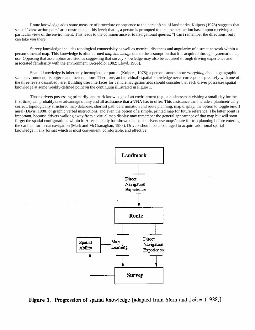
Route knowledge adds some measure of procedure or sequence to the person’s set of landmarks. Kuipers (1978) suggests thatsets of "view-action pairs" are constructed at this level; that is, a person is prompted to take the next action based upon receiving aparticular view of the environment. This leads to the common answer to navigational queries: "I can’t remember the directions, but Ican take you there."
Survey knowledge includes topological connectivity as well as metrical distances and angularity of a street network within aperson’s mental map. This knowledge is often termed map knowledge due to the assumption that it is acquired through systematic mapuse. Opposing that assumption are studies suggesting that survey knowledge may also be acquired through driving experience andassociated familiarity with the environment (Acredolo, 1982; Lloyd, 1988).
Spatial knowledge is inherently incomplete, or partial (Kuipers, 1978); a person cannot know everything about a geographic-scale environment, its objects and their relations. Therefore, an individual’s spatial knowledge never corresponds precisely with one ofthe three levels described here. Building user interfaces for vehicle navigation aids should consider that each driver possesses spatialknowledge at some weakly-defined point on the continuum illustrated in Figure 1.
Those drivers possessing primarily landmark knowledge of an environment (e.g., a businessman visiting a small city for thefirst time) can probably take advantage of any and all assistance that a VNA has to offer. This assistance can include a planimetricallycorrect, topologically structured map database, shortest path determination and route planning, map display, the option to toggle on/offaural (Davis, 1988) or graphic verbal instructions, and even the option of a simple, printed map for future reference. The latter point isimportant, because drivers walking away from a virtual map display may remember the general appearance of that map but will soonforget the spatial configurations within it. A recent study has shown that some drivers use maps’ more for trip planning before enteringthe car than for in-car navigation (Mark and McGranaghan, 1988). Drivers should be encouraged to acquire additional spatialknowledge in any format which is most convenient, comfortable, and effective.
Drivers possessing a level of spatial knowledge classified as route knowledge (e.g., a person new to an area who typicallyuses only a few, ’proven safe’ paths to get around) can benefit from a VNA which directly supports procedural navigation. The drivermight also opt to explore street map-based configurations of the environment as well. Here a dilemma surfaces: are VNAs to becomeprostheses to maximize performance at one level of spatial knowledge, or learning tools used to reach a ’higher’ knowledge level?Altruistic versus marketing (customer satisfaction) goals must be considered.
We may expect, intuitively, that drivers possessing survey level spatial knowledge may perform best when assisted by aVNA which presents both virtual map display and shortest path results. However, we must not overestimate the spatial-cognitiveability of these drivers nor underestimate their desire to explore other navigation modes. The VNA user interface should be based onthe driver’s primary knowledge level (here, survey) but with secondary and even tertiary levels of assistance to fall back upon. Evendrivers with highly-developed survey knowledge of an environment (e.g., taxi drivers with several years of experience) may choose tooperate in a procedural mode, to generate a complex shortest path description of a multi-stop shopping trip for example.
Though perhaps idealistic, the idea of coordinating multiple levels of navigation assistance within a single system is nearingan era of practicality. Just as the recent crop of fast, inexpensive microprocessors has served to catalyze the implementation of today’sVNAs, a new generation of reduced instruction set chips (RISC), parallel processors, and high-speed random access storage deviceswill do the same for the VNA of 1995. In the meantime, as they wait patiently for technological breakthroughs, researchers should bealtering their mindsets and focusing upon the user, rather than upon what the hardware is currently able to allow in a VNA. The needto focus upon the mode by which people structure space and on how they later recall and utilize that information is central to thedesign of an optimal vehicle navigation system.
3. Individual Cognitive Ability
In search of cognitive factors which affect the manner in which people structure space, it is important to remember thatcognitive activities appear to be fundamentally focused on problem-solving (Anderson, 1985). That in mind, this paper considers adriver’s level of spatial knowledge to be one of several independent factors used to explain navigation problem-solving behavior.Several other independent factors (variables) are discussed below.
Several researchers have explained individual differences in spatial cognition as being essentially a manifestation offamiliarity with the environment. Beck and Wood (1976) have suggested that people who travel extensively naturally have betteraccumulated information regarding probable layouts of cities. A person who is familiar with Spanish cities can assume a priori that anunknown city in Spain will have a central plaza with a church adjacent to it. Acredolo (1982) also stresses experiential factors ascontributing to some people’s ability to ’feel their way’ through unknown environments. But how can spatial cognition, or simply’sense of direction’ be measured? Kozlowski and Bryant (1977) have shown that people who rate themselves as having a good sense ofdirection proved so in field testing, those with self-rated bad sense of direction proving to be bad as well. The use of driver surveyscan be an easy and effective way of supporting field-testing results.
Individual differences in attention to driving cues may also be an important factor affecting navigation ability. Fielddependence, the inability of a subject to recognize individual patterns or objects from within a complex scene, has been suggested tobe contributory to some automobile accidents (Goodenough, 1976). Key objects such as ’hazardous road’ signs are often missed byfield-dependent drivers. It is possible that field dependence affects map reading ability and recognition of key landmarks as well,though it has yet to be demonstrated. During driving, the addition of stress may be a significant contributor to field-dependence andrelated poor decision-making.
This individualist viewpoint, based on the idea that people behave differently and sometimes unexpectantly in similarsituations, is often ignored by system user interface designers. Egan (1988) addresses the lack concern:
"Many computer-based systems seem to have evolved without much sensitivity to the capabilities of any user,let alone the range of capabilities of different possible users. When behavioral scientists raise concerns about usercapabilities, even they often have little to say about designing for differences among users ... they usually selectnarrowly defined user samples to minimize ’experimental error’ when comparing the mean performance ofdifferent systems" (p. 543).
4. Psychometric Studies
There are many cognitive tasks (perhaps an infinite number) which we carry out relatively unconsciously. These includeneuro-physiological tasks such as seeing and perceiving as well as complex tasks such as maneuvering an automobile through traffic.User interface designers should pay attention to recent cognitive psychology literature regarding differences in cognitive taskperformance. Psychometric research has identified a variety of basic cognitive abilities assumed to be components of skill in more
complex cognitive tasks (Thorndyke and Goldin, 1983). Based on such research, it was suggested that cognitive abilities might, forconvenience, be divided into three levels: basic, complex, and a fuzzy, mid-level class existing somewhere between (Gould, 1989).
Experimental studies offer specific support of linkage between cognitive levels. Thorndyke and Goldin (1983), for example,found that indictors of cognitive mapping skill could be gained "based upon pencil-and-paper tests of basic spatial abilities"(Thorndyke and Goldin, 1983, 208). In another study, Stasz and Thorndyke (1980) found that the single best predictor of theirdefinition of map-learning was the Building Memory Test taken from the Educational Testing Service (1976) kit. The BuildingMemory Test requires the subject to recall the positions of building icons (i.e., town hall, fire station) on a previously shown, stylizedstreet map.
Sholl and Egeth (1980) tested 49 ROTC students at Baltimore area colleges, in search of cognitive correlates of map readingability. Note that map reading is here considered distinctly from map learning. They found, surprisingly, that visual-spatial ability wasnot a strong predictor of map reading ability. Another surprise was that general mathematical and verbal ability were strong predictors.These latter two studies seem to indicate that map reading and map learning have separate cognitive bases.
Wetherell (1979) studied short-term memory for verbal and graphic route information. He tested drivers on a closed-circuitroad course. Drivers were asked to study, while in the car and stationary, either a map of a path through the course or writtendirections of the path. The navigation aids were then taken away and the drivers were asked to negotiate the path from memory. Thosedrivers who had memorized verbal directions made fewer mistakes, whether driving from the beginning of the course to the end orvice versa (forward/backward recall). Interestingly, when the drivers were blindfolded and stationary within the car, they were able torecite the directions of the path with even fewer errors than when driving the path. These findings illustrate masking, or memoryinterference (Brooks, 1968), which is marked by the poor ability of most people to execute spatial and non-spatial recall taskssimultaneously.
5. Driver Categorization?
Egan (1988) suggests developing a set of user prototypes as an approach to accommodating user differences in computerizedsystems: "...users may be classified as one of the prototypes, allowing system designers to interact with users according to theirclassification" (p.560). Following this methodology, and given that the linkage between cognitive levels (mentioned above) is reliable,researchers may then categorize drivers by navigation ability depending on the results of basic cognitive tests. It was previouslysuggested that these tests may be automated as a software toolkit and that results would be useful not in comparison to previouslydesigned "paper and pencil" tests but as measures of computer-based performance (Gould, 1989). A goal of driver categorization is toprovide individual drivers with optimal navigation aid, including computerized way-finding systems and also better direction-giving.
Field testing of the computer-based tests, in its most rigorous sense, would involve driving vehicles through actual urbanenvironments. This is often impractical due to liability insurance issues but has been done in at least one study (Streeter et al, 1985).Other, less natural testing environs such as closed circuit courses (Wetherell, 1979) have been substituted with some success. Somecombination of the two methods will be necessary to provide robust validation of navigation-category assignments.
6. Design of Future Systems
The next generation of vehicle navigation aids will surely take advantage of several new hardware innovations, which havebeen discussed and anticipated at least as far back as Cooke’s discussion of VNAs (Cooke, 1985). VNA software will, accordingly,take advantage of this new hardware. But will the next generation of software take better advantage of the human mind than doescurrent software? Freundschuh [this Technical Paper] discusses the multidisciplinary research effort which must be perpetuated inorder to provide for multiplicative rather than fractional improvement in VNA effectiveness. Much of this research effort must becentered upon the human aspect of the human-computer interaction equation. This requires greater attention to cognitive psychology,other cognitive sciences, proper statistical methodology (Carroll, 1978), and to increased involvement of the user within the designprocess. Iterative design and testing procedures have been shown to lead more quickly to systems that are both usable and appreciatedby the general user community (Egan, 1988).
Attention to multi-modal direction- giving and navigation assistance will lead to systems which are no longer functionalcompromises for large sections of the user population. Davis and Trobaugh (1987) report on a system which utilizes a topological mapdatabase (augmented DIME) to provide aural route descriptions over a cellular telephone. Such a system, linked to in-car display ofthe map database, has enormous potential for satisfying a majority of drivers possessing various levels of spatial knowledge.Furthermore, vehicle navigation and information systems (VNIS), which add auxiliary graphic and text data to the VNA architecture,will offer the ability to traverse large series of maps and perhaps aerial photographs using optical storage devices. Given a sufficientsupply of remotely sensed images of urban areas, simulated tours may become commonplace directly supporting route knowledge.
These two prospects for future VNA design, attention to the cognitive base of navigation and the provision of multi-modaluser interface, are suggested within the context of individual differences and the need to provide individual drivers with usablenavigation assistance. It is important to remember that usability is a measure most meaningful when judged by the users themselves.
Acknowledgements
This paper is a contribution to Research Initiative #2: "Languages of Spatial Relations", of the National Center forGeographic Information and Analysis (NSF grant SES-88-10917). The National Science Foundation is gratefully acknowledged.David Mark and Scott Freundschuh provided useful criticism during the writing of this paper.
References
Acredolo, L.P., 1982. The role of familiarity. In R. Cohen (Ed.), New Directions for Child Development: Children’s Conceptions ofSpatial Relationships, no. 15. San Francisco: Jossey-Bass.
Anderson, J. R., 1985. Cognitive Psychology and Its Implications, 2nd Edition. New York: W. H. Freeman and Co., 472 pp.Beck, R. J. and Wood, D., 1976. Cognitive transformation of information from urban geographical fields to mental maps. Environment
and Behavior, vol. 8, pp. 199-238.
Boyce, D.E., 1988. Route guidance systems for improving urban travel and location choices. Transportation Research A, vol. 22A, no.4, pp. 275-28 1.
Brooks, L. R., 1968. Spatial and verbal components of the act of recall. Canadian Journal of Psychology, vol. 22, no. 5, pp. 349-367.
Carroll, J. B., 1978. How shall we study individual differences in cognitive abilities?: Methodological and theoretical perspectives.Intelligence, vol. 2, pp. 87-115.
Cooke, D., 1985. Vehicle navigation appliances. Proceedings, 7th International Symposium on Computer-Assisted Cartography.
Couclelis, H., 1988. The truth seekers: Geographers in search of the human world. In R. Golledge, H. Couclelis, and P. Gould (Eds.),A Ground for Common Search. Santa Barbara: The Santa Barbara Geographical Press, pp. 148-155.
Davis, J.R., 1988. A voice interface to a direction giving program, Speech Research Group Technical Memo 2. The, MediaLaboratory, Mass. Institute of Technology, January 1988.
Davis, J.R. and T.F. Trobaugh, 1987. Direction assistance, Speech Research Group Technical Memo 1. The Media Laboratory, Mass.Institute of Technology, December 1987.
Downs, R. and Stea, D., 1977. Maps in Minds. New York: Harper and Row.
Egan, D. E., 1988. Individual differences in human-computer interaction. In M. Helander (Ed.), Handbook of Human-ComputerInteraction. North Holland: Elsevier Science Publishers.
Ekstrom, R. B., French, J. W., and H. H. Harman, 1976. Manual for Kit of Factor-referenced Cognitive Tests. Princeton: EducationalTesting Service.
French, R.L., 1987. Automobile navigation in the past, present, and future. Proceedings, 8th International Symposium on Computer-Assisted Cartography, pp. 542-551.
French, R.L., 1989. Cars that know where they’re going. The Futurist, pp. 29-36, May-June 1989.
Freundschuh, S., 1989. Can Survey (map view) Knowledge be Acquired from Procedural Knowledge? Presented at the AnnualMeeting of the Association of American Geographers, Baltimore, Maryland.
Gollege, R., 1988. Integrating Spatial Knowledge. Presented at 3rd IGU International Symposium of Spatial Data Handling, Sydney,Australia.
Goodenough, D.R., 1976. A review of individual differences in field dependence as a factor in auto safety. Human Factors, 18(l), pp.53-62.

Gould, M.D., 1989. A Toolbox for Navigation Research. Presented at the Annual Meeting of the Association of AmericanGeographers, Baltimore, Maryland.
Kozlowski, L.T. and K.J. Bryant, 1977. Sense of direction, spatial orientation, and cognitive maps. Journal of ExperimentalPsychology: Human Perception and Performance, vol. 3, no. 4, pp. 590-598.
Kuipers, B., 1978. Modeling spatial knowledge. Cognitive Science, vol. 2, pp. 129-153.
Lloyd, R., 1988. Cognitive maps: Encoding and decoding information. Annals of the Association of American Geographers, vol. 79,no. 1, pp. 101-124.
Mark, D. M., and Frank, A., 1989. Concepts of space and spatial language. Proceedings, 9th International Symposium on Computer-Assisted Cartography, Baltimore, Maryland, pp. 538-556.
Mark, D. M., and McGranaghan, M., 1986. Effective provision of navigation assistance to drivers: A cognitive science approach.Proceedings, AutoCarto London Conference, vol. 2, pp. 399-408.
Mark, D. M. and McGranaghan, M., 1988. Map use and map alternatives: An experiment in intra-urban navigation. The CanadianGeographer, vol. 32, pp. 69-75.
Olson, D. R., and Bialystok, E., 1983. Spatial Cognition: The Structure and Development of Mental Representations of SpatialRelations. New Jersey: Lawrence Erlbaum Associates.
Peuquet, D. J., 1988. Representations of geographic space: Toward a conceptual synthesis. Annals of the Association of AmericanGeographers, vol. 78, no. 3, pp. 375-394.
Pick, H. L., and Lockman, J. J., 1983. Map reading and spatial cognition. In Pick and Acredolo (Eds.), Spatial Orientation. New York:Plenum Press, pp. 219-224.
Sholl, M. J., and Egeth, H. E., 1980. Cognitive Correlates of Map Reading Ability. Department of Psychology, The Johns HopkinsUniversity, Baltimore, Maryland.
Sedgwick, H. A., 1982. Visual modes of spatial orientation. In M. Potegal (Ed.), Spatial Abilities: Development and PhysiologicalFoundations. New York: Academic Press, pp. 3-28.
Simutis, Z. M., and Barsam, H. F., 1983. Terrain visualization and map reading. In Pick and Acredolo (Eds.), Spatial Orientation.New York: Plenum Press, pp. 161-192.
Stasz, C., and Thorndyke, P. W., 1980. The Influence of Spatial-visual Ability and Study Procedures on Map-learning Skill. TechnicalReport N-1501-ONR, Santa Monica: Rand Corporation.
Stem, E. and D. Leiser, 1988. Levels of spatial knowledge and urban travel modeling. Geographical Analysis, vol. 20, no. 2, pp. 140-155.
Streeter, L. A., and Vitello, D., 1986. A profile of driver’s map reading abilities. Human Factors, vol. 28, pp. 233-239.
Streeter, L.A., Vitello, D. and S.A. Wonsiewicz, 1985. How to tell people where to go: comparing navigational aids. InternationalJournal of Man/Machine Systems, vol. 22, no. 5, pp. 549-562.
Thomdyke, P. A. and Goldin, S. E., 1983. Spatial learning and reasoning skill. In Pick and Acredolo (Eds.) Spatial Orientation. NewYork: Plenum Press, pp. 195-215.
Thorndyke, P. A. and Hayes-Roth, B., 1982. Differences in spatial knowledge acquired from maps and navigation. CognitivePsychology, vol. 14, pp. 560-589.
Trowbridge, C.C., 1913. Fundamental methods of orientation and imaginary maps. Science, vol. 38, pp. 888-897.

Weitzman, D. 0., 1979. Individual Differences in Geographic Orientation and Spatial Memory Representation. Presented at theAnnual Meeting of the American Psychological Association.
Wetherell, A., 1979. Short-term memory for verbal and graphic route information. Proceedings: Human Factors Society, 23rd AnnualMeeting, pp. 464-468.
A CONCEPTUAL MODEL FOR VEHICLE NAVIGATION SYSTEMS
DAVID M. MARKNational Center for Geographic Information and Analysis
Department of GeographyState University of New York at Buffalo
Buffalo, New York, 14260 U.S.A.
Abstract In formal English, the term "navigate" is associated with ships, and more recently, with aircraft. However, morerecently, the term "vehicle navigation" has been applied to land vehicles as well. Support of human navigation has long been a vitalfunction of maps. Recent technological developments have led to new forms of navigation aids, not all of which include maps.Cognitive science studies the workings of the mind, and provides a useful theoretical basis for examining the navigation process andits relation to spatial learning. This in turn provides a conceptual framework for an evaluation of maps and map-alternatives for roadnavigation. This paper defines a number of terms and concepts related to vehicle navigation, and presents a model which can be usedin designing and evaluating components of the navigation system.
1. Introduction
In formal English, the term navigate normally is associated with determining courses for ships, and more recently, foraircraft. However, the processes of position-finding, route-planning, and route-following on land are similar in many ways to those inthe aforementioned, less constrained environments, and more recently, the term vehicle navigation has been applied to way- findingfor automobiles, trucks, or other land vehicles (Cooke, 1985; see also the title of this Conference). Support of human navigation haslong been a vital function of maps (Head, 1984; Petchenik, 1989). However, recent technological developments have led to new formsof navigation aids (Mark, Gould, and McGranaghan, 1987; McGranaghan, Mark, and Gould, 1987), and not all of these include maps.Cognitive science studies the workings of the mind, and represents a useful basis for examining the navigation process and its relationto spatial learning (Kuipers, 1978, 1983a, 1983b; Mark, 1987; Mark and McGranaghan, 1986). This in turn provides a conceptualframework for an evaluation of maps and map-alternatives for road navigation (Mark and McGranaghan, 1988).
The chief purpose of this paper is to present a conceptual model for vehicle navigation systems, and show how it relates tothe cognitive processes that go on during vehicle navigation and driving. The paper also presents a model which can be used indesigning and evaluating components of the navigation system.
2. Cognitive Science, Way-finding, and Navigation
Cognitive science represents an amalgam of the explanatory side of artificial intelligence with the cognitive sides ofpsychology, linguistics, anthropology, geography, and related fields. It has been called "The Mind’s New Science" (Gardner, 1985).Human geography has a long tradition of concern for spatial cognition, and for the ways in which mental representations ofgeographic space influence spatial behavior. Recently, research on these topics has become the main theme of Research Initiative 2,"Languages of Spatial Relations", of the U.S. National Center for Geographic Information and Analysis (NCGIA) (Mark, 1988, 1989;Mark and Frank, 1989; Mark and others, 1989). In general, implementation of cognitively-sound models of geographic space shouldlead to improved Geographic Information Systems (GIS) interfaces, spatial query languages, and spatial inference. Vehicle navigationsystems represent a particularly’ fruitful field for research combining cognitive science, geography, and information technology, andhas been identified as an important element in the research agenda of the NCGIA (Mark, 1989).
2.1 Acquisition of Geographic Knowledge: Theory
In a cognitive science framework, Benjamin Kuipers (1978, 1983a, 1983b) has developed a formal model of the process bywhich people learn a large- scale (geographic space). This models incorporates some aspects of the theories of Kevin Lynch (1960)and Piaget and Inhelder (1956), and is similar to models of spatial knowledge acquisition proposed and discussed by Downs and Stea(1977) and by Thorndyke and his co-workers (Goldin and Thorndyke, 1982; Thorndyke and Hayes-Roth, 1982).
In Kuipers’ TOUR model, as a person moves through such space, that person observes views and performs actions. A view isdefined as the total of all sensory experiences, at a point and oriented in a particular direction; for most individuals and situations, aview is dominated by visual inputs. A route can be characterized as a set of view-action pairs, denoted (V->A); if the (V->A) pairs inthe collection are stored in the mind (long-term memory), then the route can be retraced at a later time. In fact, as one navigates in anurban street network, the action associated with many views is simply "continue"; thus (V->continue) pairs may be omitted, and only(V->A) pairs associated with turns or other significant actions are stored.
One might think that the set of (V->A) pairs must be ordered in order to be useful; however, as pointed out by Kuipers, ifviews are unique, such order is unnecessary--after an action is performed, the environment provides the next view. On the other hand,if the next view after an action is remembered (i.e., either as an ordered list of (V->A) pairs, or as a set of (V->A)->V’ triples), thenroutes can be re-created in the mind, and described to others. That people often store only (V->A) pairs is indicated by the notuncommon statement: "I can’t tell you how to get there, but I can take you there." Spatial knowledge consisting only of routeinformation (view-action pairs or view -action-view triples) may be termed procedural knowledge of geographic space (Mark andMcGranaghan, 1986; Thorndyke and Hayes-Roth, 1982). This is essentially a stimulus-response model of navigation. Proceduralknowledge may predominate for people in habitual situations and probably predominates for most other animals.
Often, people recognize that the same view occurs as an element of different routes. These common views are used inKuipers’ model to construct places, consisting of ordered circuits of views at a point. Knowledge of which places are connected towhich others is termed topological knowledge (Kuipers, 1978, 1983a, 1983b). At this level of spatial knowledge, people often knowon which sides of major linear features other features lie; with topological knowledge of large-scale space, individuals often can plannew routes between places.
Eventually, individuals may construct geometrical models of space in their minds. Such models locate places in a cartesiancoordinate system; routes include distances between places, angles of intersections, etc. People with geometrical knowledge can pointnorth, or point in the same direction that is "out their front door" when at home. However, experimental research by Thorndyke andHayes-Roth (1982) suggests that people may be able to build reasonably accurate geometrical models of large-scale space morerapidly from maps than they can from real-world experience. They stated: "With moderate exposure, map learning is superior forjudgements of relative location and straight-line distances among objects. Learning from navigation is superior for orienting oneselfwith respect to unseen objects and estimating route descriptions." (Thorndyke and Hayes-Roth, 1982, p. 560). They also found thatwith extensive exposure to the environment, the superiority of map-learners for the tasks mentioned above vanished. This differencebetween map-based learning and experiential learning probably applies to spatial learning of a city street network as well, at least forcities which do not have a rectangular grid of streets (Mark and McGranaghan, 1986). A recent study by Lloyd (1989) appears toconfirm this conjecture, which will be tested more directly in experimental research by Scott Freundschuh at Buffalo.
2.2 Components of Vehicle Navigation Systems
Navigation is here defined as any activity in which an organism or machine controls movement through large-scale(geographic) space to a specific destination (goal). This paper focuses on navigation by people, although the model in principle shouldapply to other animals, and to autonomous vehicles. Acts of navigation include a combination of cognitive processes and sensorimotoractions; a significant part of the navigation activity occurs in the mind. Human navigation activities are not restricted to drivers andpilots: automobiles passengers often are involved in navigation activities (when they provide information or advice to drivers),whereas passengers on commercial aircraft or on busses rarely are so involved. The Vehicle Navigation System (VNS) is hereindefined to include all minds, machines, objects, and devices involved in navigation. Components of the system may include (1) themind of the driver of the vehicle; (2) the minds of any other persons who participate in navigation activities during travel (usuallypassengers, but possibly individuals not in the vehicle, but in contact with the driver remotely); and (3) any Vehicle Navigation Aids(VNAs), that is, devices or materials used by any of the participants during navigation, and which contribute to or influence thenavigation activity.
Recently, McGranaghan, Mark, and Gould (1987) discussed components of vehicle navigation aids. Two of these wereexplicitly identified by Donald Cooke (1985, p. 108) as required properties of what he termed "Vehicle Navigation Appliances":
1) "[they) must be able to locate the vehicle on the ground" [location -keeping function]; and2) "[they] must be able to display the location in a familiar and useful form" [output/communication function].
McGranaghan, Mark, and Gould (1987) broadened these definitions, stating that the location function can be performed byany component of the VNS, including the human mind(s). Secondly, the term "display" should be interpreted to include provision ofnavigation assistance in either verbal, symbolic, or pictorial (map) form, to be perceived either aurally or visually.
Marvin White has highlighted a third critical VNA component:
3) the geographic database and associated storage device (data-base function);
To these, McGranaghan, Mark, and Gould (1987) added two other functions:
4) planning of a route from the current location to the destination (route-planning function); and5) determining a set of driving instructions for actually traversing the route (instruction-generation function).

3. Vehicle Navigation-aid Systems
3.1 Paper Road Maps
Even if a general and all-inclusive definition of ’map’ proves to be elusive (Vasiliev and others, 1989), a road map or roadatlas represents a prototypical map. In fact, it probably represents the first type of map encountered by most North American children.There is no need to describe this ubiquitous graphic depiction of streets, roads, and highways, and paper road-maps are an effectivenavigation aid for many (but almost certainly not all) drivers. However, as will be discussed below, effective VN systems can bedesigned which do not include maps; thus the future role of the road map in vehicle navigation must be assessed in light of recenttechnological advances.
3.2 Procedural Directions
In essence, a step in procedural directions has just two elements: what to do next, and when to do it (Mark and McGranaghan,1986). Such directions can be transmitted to the drivers through the use of words, of signals/symbols, or in graphic form, the last eitheras icons or as map elements. Furthermore, verbal or symbolic directions can be presented either visually or aurally. As producers ofgraphic maps, academic cartographers may fail to appreciate the potential utility (and power) of procedural directions. However, mostdrivers probably have had the experience of driving in an unfamiliar area with a passenger who has good local knowledge; that suchexperiences usually result in efficient navigation demonstrates that verbal-procedural navigation instructions can be an extremelyeffective form of navigation aid. Even in our home areas, we often give people rides to places to which we have never driven. In suchcircumstances, most drivers are very willing to accept verbal (vocal) directions given in real-time, as needed, during the trip. In fact,they commonly accept such directions unquestioningly. Although some people may wish to see a map before or after a trip, in order toplace the path taken and the new location into a geometric framework ("in order to see where they have been," or "where they are"),such map access is not essential to the navigation process. In fact, it seems that many people would prefer to avoid maps as much aspossible.
A prominent geographer, speaking as an automobile driver, has suggested that an in-car computer system giving verbal(vocal) directions would not be very desirable or effective, because the computer could not be trusted to give good, or even correct,directions; interestingly, the same person would trust that same computer to draw a map on a CRT in the car. However, the "localexpert navigator" phenomenon clearly demonstrates that real-time verbal (vocal) instructions given during travel can be a veryeffective navigation aid. In fact, is difficult to imagine a method that would be more effective (other than computer- controlledsteering).
4. Some Examples
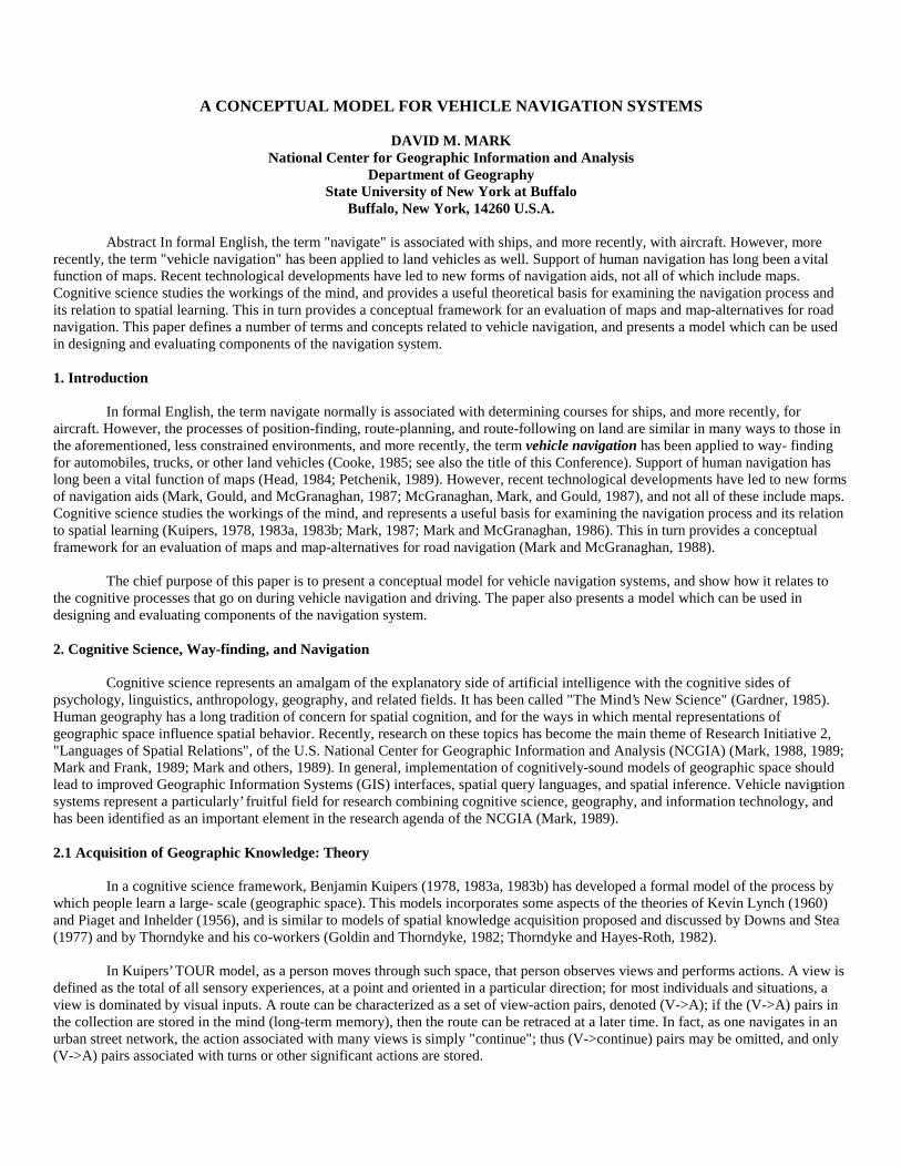
The following diagrams illustrate the way in which various VNS functions are performed by different components of theVehicle Navigation System. All driving areas are assumed to be unfamiliar to the drivers, except where noted to the contrary.
First, let us examine car navigation using the traditional paper road map from the perspective of the model of the VNSdeveloped above (see Figure 1). The printed map performs both function 2 (display) and function 3 (data- base); the mind of the driveror navigator performs functions 1 (location), 4 (route-planning), and 5 (instruction-generation).

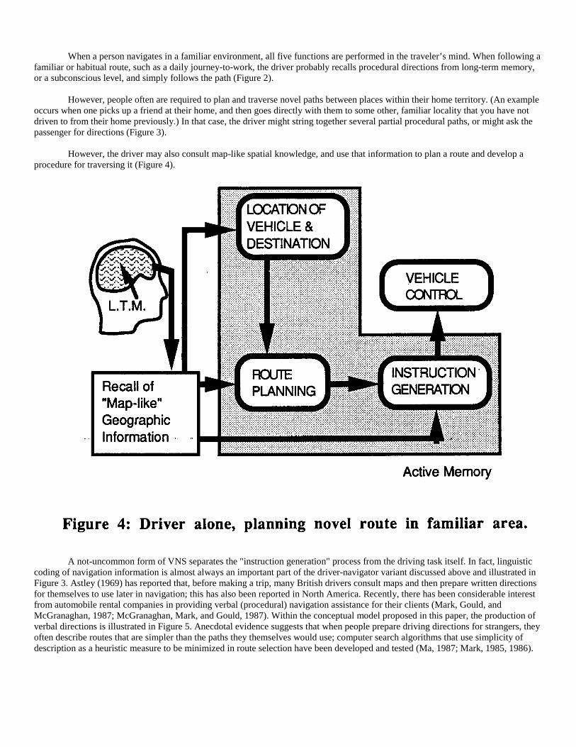
When a person navigates in a familiar environment, all five functions are performed in the traveler’s mind. When following afamiliar or habitual route, such as a daily journey-to-work, the driver probably recalls procedural directions from long-term memory,or a subconscious level, and simply follows the path (Figure 2).
However, people often are required to plan and traverse novel paths between places within their home territory. (An exampleoccurs when one picks up a friend at their home, and then goes directly with them to some other, familiar locality that you have notdriven to from their home previously.) In that case, the driver might string together several partial procedural paths, or might ask thepassenger for directions (Figure 3).
However, the driver may also consult map-like spatial knowledge, and use that information to plan a route and develop aprocedure for traversing it (Figure 4).
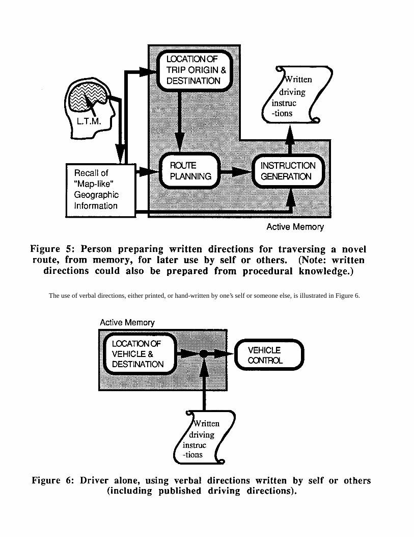
A not-uncommon form of VNS separates the "instruction generation" process from the driving task itself. In fact, linguisticcoding of navigation information is almost always an important part of the driver-navigator variant discussed above and illustrated inFigure 3. Astley (1969) has reported that, before making a trip, many British drivers consult maps and then prepare written directionsfor themselves to use later in navigation; this has also been reported in North America. Recently, there has been considerable interestfrom automobile rental companies in providing verbal (procedural) navigation assistance for their clients (Mark, Gould, andMcGranaghan, 1987; McGranaghan, Mark, and Gould, 1987). Within the conceptual model proposed in this paper, the production ofverbal directions is illustrated in Figure 5. Anecdotal evidence suggests that when people prepare driving directions for strangers, theyoften describe routes that are simpler than the paths they themselves would use; computer search algorithms that use simplicity ofdescription as a heuristic measure to be minimized in route selection have been developed and tested (Ma, 1987; Mark, 1985, 1986).
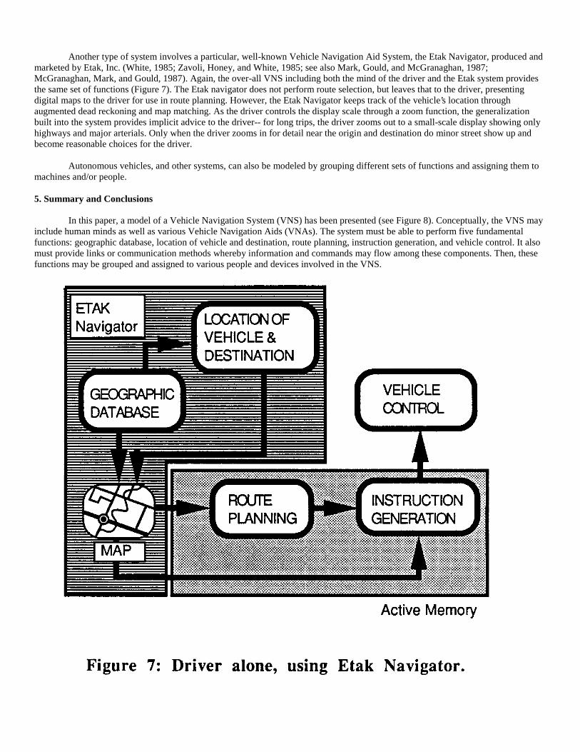
The use of verbal directions, either printed, or hand-written by one’s self or someone else, is illustrated in Figure 6.
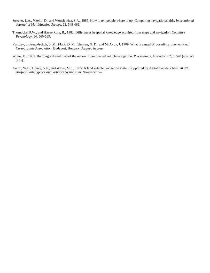
Another type of system involves a particular, well-known Vehicle Navigation Aid System, the Etak Navigator, produced andmarketed by Etak, Inc. (White, 1985; Zavoli, Honey, and White, 1985; see also Mark, Gould, and McGranaghan, 1987;McGranaghan, Mark, and Gould, 1987). Again, the over-all VNS including both the mind of the driver and the Etak system providesthe same set of functions (Figure 7). The Etak navigator does not perform route selection, but leaves that to the driver, presentingdigital maps to the driver for use in route planning. However, the Etak Navigator keeps track of the vehicle’s location throughaugmented dead reckoning and map matching. As the driver controls the display scale through a zoom function, the generalizationbuilt into the system provides implicit advice to the driver-- for long trips, the driver zooms out to a small-scale display showing onlyhighways and major arterials. Only when the driver zooms in for detail near the origin and destination do minor street show up andbecome reasonable choices for the driver.
Autonomous vehicles, and other systems, can also be modeled by grouping different sets of functions and assigning them tomachines and/or people.
5. Summary and Conclusions
In this paper, a model of a Vehicle Navigation System (VNS) has been presented (see Figure 8). Conceptually, the VNS mayinclude human minds as well as various Vehicle Navigation Aids (VNAs). The system must be able to perform five fundamentalfunctions: geographic database, location of vehicle and destination, route planning, instruction generation, and vehicle control. It alsomust provide links or communication methods whereby information and commands may flow among these components. Then, thesefunctions may be grouped and assigned to various people and devices involved in the VNS.

Adoption of this model allows researchers to focus more clearly on particular components of the system and on theassociated research questions. How should the database represent, store, and retrieve geographic information? How should thevehicle’s location be determined? What objective functions and what algorithms or methods should be used for route selection? Howcan good driving instructions be produced from topological and/or geometric descriptions of routes? How should VNAs communicatewith the driver? (Contrasts between verbal (aural) presentation and graphic map presentation have been studied by Streeter and her co-workers (Streeter and Vitello, 1986; Streete, Vitello, and Wonsiewicz, 1985), but much more work is needed. How should driverpreferences be traded off against driver performance?) And, perhaps most importantly, which functions should be performed by theminds of the people in the car, which should be assigned to on-board or remote computers, and which should be left to analog devicessuch as maps? And how do vehicle types, geographic regional characteristics, and individual and cross-cultural and cross-linguisticdifferences between drivers influence design criteria for optimal or even adequate Vehicle Navigation Systems? Clearly, there areenough research problems here to challenge engineers, cognitive scientists, geographers, and others for some time to come!
Acknowledgments
This paper represents part of Research Initiative 2, "Languages of Spatial Relations", of the National Center for GeographicInformation and Analysis, supported by a grant from the National Science Foundation (SES-88-10917); support by NSF is gratefullyacknowledged. By electronic mail, the author can be reached at geodmm @ ubvms.cc.buffalo.edu or geodmm @ ubvms.bitnet.
References
Astley, R. W., 1969. A note on the requirements of road map users. The Cartographic Journal, 6: 130.
Cooke, D. F., 1985. Vehicle navigation appliances. Proceedings, Seventh International Symposium on Computer-AssistedCartography (Auto-Carto 7), pp. 108-115.
Downs, R.M., and Stea, D., 1977. Maps in Minds. New York: Harper & Row Publishers.
Gardner, H., 1985. The Mind’s New Science: A History of the Cognitive Revolution. New York: Basic Books, Inc.

Goldin, S. E., and Thorndyke, P. W., 1982. Simulating Navigation for Spatial Knowledge Acquisition. Human Factors, 24: 457-471.
Head, C. G., 1984. The map as natural language: a paradigm for understanding. Cartographica, 21: 1-32.
Kuipers, B., 1978. Modeling spatial knowledge. Cognitive Science, 2: 129- 153.
Kuipers, B., 1983a. The cognitive map: Could it have been any other way? In Pick, H. L., Jr., and Acredolo, L. P. (Eds.), SpatialOrientation: Theory, Research, and Application. New York, NY: Plenum Press, pp. 345-359.
Kuipers, B., 1983b. Modeling human knowledge of routes: Partial knowledge and individual variation. Proceedings, AAAI 1983Conference, The National Conference on Artificial Intelligence, pp. 1-4.
Lloyd, R., 1989. Cognitive maps: Encoding and decoding information. Annals of the Association for American Geographers, 79, 101-124.
Lynch, K., 1960. The Image of the City. Cambridge, Massachusetts: MIT Press.
Ma, P., 1987. An algorithm to generate verbal instructions for vehicle navigation using a geographic database. The East LakesGeographer, 22: 44-60.
Mark, D. M., 1985. Finding simple routes: ’Ease of description’ as an objective function in automated route selection. Proceedings,Second Conference on Artificial Intelligence Applications (IEEE), Miami Beach, December 11-13, pp 577-581.
Mark, D. M., 1986. Automated route selection for navigation. IEEE Aerospace and Electronic Systems Magazine, 1: 2-5.
Mark, D. M., 1987. On giving and receiving directions: Cartographic and cognitive issues. Proceedings, Eighth InternationalSymposium on Computer-Assisted Cartography (Auto-Carto 8), Baltimore, Maryland, pp. 562-571.
Mark, D. M., 1988. Cognitive and Linguistic Aspects of Geographic Space: Report on a Workshop. Santa Barbara, CA: NationalCenter for Geographic Information and Analysis.
Mark, D. M., 1989. Languages of Spatial Relations: Researchable Questions and NCGIA Research Agenda. Santa Barbara, CA:National Center for Geographic Information and Analysis, Report 89-2A.
Mark, D. M. and Frank, A. U., 1989. Concepts of space and spatial language. Proceedings, Ninth International Symposium onComputer-Assisted Cartography (Auto-Carto 9), Baltimore, Maryland, pp. 538-556.
Mark, D. M., Frank, A. U., Egenhofer, M. J., Freundschuh, S. M., McGranaghan, M., and White, R. M., 1989. Languages of SpatialRelations: Initiative Two Specialist Meeting Report. Santa Barbara, CA: National Center for Geographic Information and Analysis,Report 89-2.
Mark, D. M., Gould, M. D., and McGranaghan, M., 1987. Computerized navigation assistance for drivers. The ProfessionalGeographer, 39, 215-220.
Mark, D. M., and McGranaghan, M., 1986. Effective provision of navigation assistance for drivers: A cognitive science approach.Proceedings, Auto-Carto London, London, England, September 14-19, 2: 399-408.
Mark, D. M., and McGranaghan, M., 1988. Map use and map alternatives: An experiment in intraurban navigation. The CanadianGeographer, 32, 69-75.
McGranaghan, M., Mark, D. M., and Gould, M. D., 1987. Automated provision of navigation assistance to drivers. The AmericanCartographer, 14, 121-138.
Petchenik, B. B., 1989. The road not taken. The American Cartographer, 16: 47-50.
Piaget, J., and Inhelder, B., 1956. The Child’s Conception of Space. London: Routledge & Kegan Paul.
Streeter, L.A., and Vitello, D. 1986. A profile of drivers’ map- reading abilities. Human Factors, 28: 223-239.
Streeter, L.A., Vitello, D., and Wonsiewicz, S.A., 1985. How to tell people where to go: Comparing navigational aids. InternationalJournal of Man/Machine Studies, 22, 549-462.
Thorndyke, P.W., and Hayes-Roth, B., 1982. Differences in spatial knowledge acquired from maps and navigation. CognitivePsychology, 14, 560-589.
Vasiliev, I., Freundschuh, S. M., Mark, D. M., Theisen, G. D., and McAvoy, J. 1989. What is a map? Proceedings, InternationalCartographic Association, Budapest, Hungary, August, in press.
White, M., 1985. Building a digital map of the nation for automated vehicle navigation. Proceedings, Auto-Carto 7, p. 570 (abstractonly).
Zavoli, W.B., Honey, S.K., and White, M.S., 1985. A land vehicle navigation system supported by digital map data base. ADPAArtificial Intelligence and Robotics Symposium, November 6-7.