it infrastructure for bim and gis – 3d data, semantics ... · •works with oracle spatial and...
TRANSCRIPT


Copyright © 2017 Oracle and/or its affiliates. All rights reserved. |
“IT Infrastructure for BIM and GIS – 3D Data, Semantics, and Workflows”
Hans Viehmann Product Manager EMEA ORACLE Corporation November 23, 2017 @SpatialHannes
2

Copyright © 2017 Oracle and/or its affiliates. All rights reserved. |
Safe Harbor Statement
The following is intended to outline our general product direction. It is intended for information purposes only, and may not be incorporated into any contract. It is not a commitment to deliver any material, code, or functionality, and should not be relied upon in making purchasing decisions. The development, release, and timing of any features or functionality described for Oracle’s products remains at the sole discretion of Oracle.
3

Copyright © 2017 Oracle and/or its affiliates. All rights reserved. |
Major challenges of infrastructure projects IT perspective
• Creating a Single-Source-of-Truth for BIM and GIS
–Managing all kinds of spatial and non-spatial data
– Providing metadata for search
• Integrating spatial data into business processes – Supporting entire asset management lifecycle
– Automated workflows between servers, rather than spatial data in silos
• Interoperability on data-, process- and application-level
–Making use of valuable geospatial data wherever needed
– Delivering consistent information across domains (semantic interoperability)
7

Copyright © 2017 Oracle and/or its affiliates. All rights reserved. |
Managing data in BIM projects Typical issues today
• Different kinds of data are held in files or speciality data stores
– Need different skill sets for each specialized system
–Making integrated analysis difficult
• Support for new datatypes is required – LiDAR data collection growing particularly rapidly
• Finding the appropriate dataset is challenging
–Metadata are either incomplete or not accessible/searchable
• Datasets are semantically inconsistent
– Identical terms do not necessarily mean the same thing
8

Copyright © 2017 Oracle and/or its affiliates. All rights reserved. |
Solution approach: Data integration Combining all kinds of geospatial data, metadata and attribute data
• Integrated storage allows joint analysis
–Without moving potentially large datasets between systems
– Including metadata for efficient search
• Database offers semantic technologies for further analysis
• Using a single system simplifies application development significantly – Same development paradigm and toolset
• Operational benefits, especially when used in the cloud
– Consistent platform for administration
– Comprehensive security mechanisms
9

Copyright © 2017 Oracle and/or its affiliates. All rights reserved. |
Data integration requires spatially-enabled database Ideally supporting semantic integration through RDF
10
Oracle Spatial and Graph
“Points” “Lines” “Polygons”
Rasters
Topologies
3D f1
f2 n1 n2
e1
e2 e3
e4
Network Graphs RDF Semantic Graphs
“Points”
Web Services (OGC)
SPARQL End Point
Geocoding, Routing
Inferencing

Copyright © 2017 Oracle and/or its affiliates. All rights reserved. |
Case Study: ÖBB-Infrastruktur AG, R&D Implemented by IQsoft, Austria
• Optimized railway planning, construction and maintenance
• Integrated LiDAR, raster and vector data management
• Storing and processing >8 billion points of objects along railway tracks
• Enables LiDAR data to be viewed with existing infrastructure vector data
• Comprehensive metadata management through CSW standard
• Data delivery through OGC WebServices
11
“[This technology…] is indispensable to process geospatial data with high efficiency at low cost” Dr. Michaela Haberler-Weber ÖBB-Infrastruktur AG, R&D
Scre
ensh
ot
cou
rtes
y o
f: IQ
soft
, Au
stri
a

Copyright © 2017 Oracle and/or its affiliates. All rights reserved. |
Spatial Data Types are not enough Using the data requires object model • Modeling required for any kind of analysis beyond visualization
– Associating objects with geometry, topology, semantics, appearance, ...
• CityGML is established standard for urban infrastructure
– Information model to represent relevant 3D urban objects
– Defining classes and relations for these objects
– XML-based format to exchange and store data (GML3-based application schema)
– Standardized by OGC, currently in version 2.0.0
– Can be used to derive logical data model in databases
12

Copyright © 2017 Oracle and/or its affiliates. All rights reserved. |
3DCityDB implements CityGML Open source data model - www.3dcitydb.org
• Semantically rich, hierarchically structured model
• Five different Levels of Detail (LODs), including textures and facades
• Representation of generic and prototypical 3D objects
• Free, also recursive aggregation of geo objects
• Complex digital terrain models (DTMs)
• Management of large aerial photographs using SDO_GEORASTER objects
• Version and history management
• Matching/merging of building features
• Works with Oracle Spatial and Graph 10gR2, 11g and 12c
13

Copyright © 2017 Oracle and/or its affiliates. All rights reserved. |
Case study: City of Berlin – 3D City Model Implemented by TU Berlin
• 3D vector and raster data in 3DCityDB
• Data model based on CityGML
• 560000 buildings, reconstructed from 2D cadastre and LiDAR data
• Textures extracted from oblique aerial photography
Images courtesy of: TU Berlin, Institute for Geodesy and Geoinformation

Copyright © 2017 Oracle and/or its affiliates. All rights reserved. |
Integrating spatial data into business processes Typical issues today
• GIS systems disconnected from business systems
– Dedicated, specialized systems
– High training cost
– Costly operations and maintenance
• Manual effort in delivering location-related information
– Labour intensive, time consuming, error prone
– Not scalable for large infrastructure projects
• Not making use of the full value of geospatial information
15

Copyright © 2017 Oracle and/or its affiliates. All rights reserved. |
Solution approach: Service-oriented Architectures With spatial data seamlessly integrated
• Implementing automated workflows across systems
– Including the GIS System(s)
– Loose coupling allowing simple transition to cloud computing
• Making use of standard IT development paradigm – Structured SOA approach, resulting in reduced cost through reuse
– Using graphical design tools for rapid application development
• Operational benefits
– Integrated administration and Business Activity Monitoring
– Comprehensive security mechanisms
16
Copyright © 2017 Oracle and/or its affiliates. All rights reserved. |
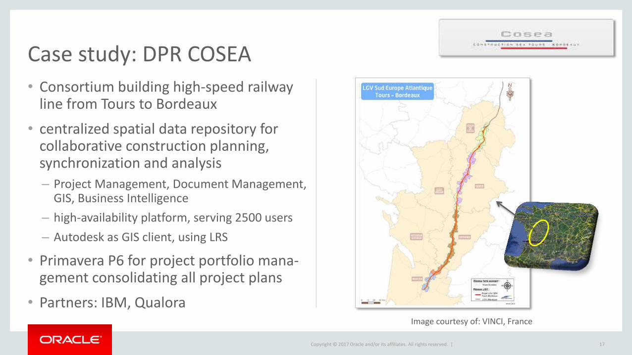
Case study: DPR COSEA
• Consortium building high-speed railway line from Tours to Bordeaux
• centralized spatial data repository for collaborative construction planning, synchronization and analysis
– Project Management, Document Management, GIS, Business Intelligence
– high-availability platform, serving 2500 users
– Autodesk as GIS client, using LRS
• Primavera P6 for project portfolio mana-gement consolidating all project plans
• Partners: IBM, Qualora
17
Image courtesy of: VINCI, France

Copyright © 2017 Oracle and/or its affiliates. All rights reserved. |
Interoperability Typical issues today
• More than one GIS or mapping component in the organization
– Need to share data online
• Adding more components to the infrastructure
– Specific tools for various purposes
– Integrating maps into business applications
• Demand to integrate maps and data from cloud-based services
–making use of available datasources
• Identical terms in different systems don‘t necessarily mean the same thing
– Leading to incorrect or inconsistent results
18

Copyright © 2017 Oracle and/or its affiliates. All rights reserved. |
Solution approach: Open standards on all levels OGC standards for Geospatial data
• Using open standards at database level
–OGC Simple Features specification, ISO SQL/MM
– Allowing data access from many tools and components through SQL
– Conversion to and from GML, KML (or GeoJSON as OGC candidate standard)
– Supporting semantic queries using GeoSPARQL
• Using OGC Webservices standards
–WMS to provide maps, WMTS to provide map tiles (both available through MapViewer)
–WFS and WFS-T to retrieve or manipulate data (available as part of Spatial and Graph license)
19

Copyright © 2017 Oracle and/or its affiliates. All rights reserved. |
Oracle 12c Spatial and Graph
Open and Interoperable spatial database

Copyright © 2017 Oracle and/or its affiliates. All rights reserved. |
Open Source Tools integrated with Oracle Spatial and Graph

Copyright © 2017 Oracle and/or its affiliates. All rights reserved. |
Case Study: Crossrail, UK Spatial Data Warehouse, Bentley and Esri clients
• Large Engineering & Construction project in UK
• 21 km twin tunnel under City of London, 90 km of new railway line
• Visualization and Analysis, incl. 3D data management
• Oracle Spatial and Graph as „single source of truth“
– Database for 300+ staff and contractors as well as the public
– Serving Bentley Map, Geo Web Publisher, ESRI ArcMap
– 500+ layers of information, 45.000.000+ records
– integrated security
• using London Survey Grid for accuracy Image courtesy of: Crossrail, UK

Copyright © 2017 Oracle and/or its affiliates. All rights reserved. |
Semantic technologies Using linked data concepts to associate data with meaning
• Automated integration of data from different sources
– Creating a semantic layer across silo‘d systems
– Using well-defined vocabularies and ontologies
– Based on W3C standards including the Resource Description Framework (RDF), the Web Ontology Language (OWL), SPARQL, RDB2RDF, ...
– Allowing consistent query, reporting and analysis
• Enabling inferencing to gain new knowledge
– Derive new information or verify consistency
• Functionality in Oracle database since Oracle 10gR2 – Triple store, inferencing engine, SPARQL/GeoSPARQL support, RDB2RDF support, ...
23

Copyright © 2017 Oracle and/or its affiliates. All rights reserved. |
Summary IT Infrastructure for BIM and GIS
• Create a Single-Source-of-Truth for BIM and GIS
– Vector data in 2D and 3D, raster imagery, point cloud data
– Including metadata catalog for search
• Integrate spatial data into business processes – Supporting entire asset management lifecycle
– Automated workflows across systems (eg. work orders, invoices, ...)
• Ensure interoperability on data-, process- and application-level
– Technical interoperability to supply more than one solution with geospatial data
– Semantic interoperability by using a common Vocabulary/Ontology
25

Copyright © 2017 Oracle and/or its affiliates. All rights reserved. |
More resources
• Further information on oracle.com
–www.oracle.com/goto/spatial
• Blogs
– https://blogs.oracle.com/oraclespatial
• Developer forums on OTN – https://community.oracle.com/community/database/oracle-database-options/spatial
• LinkedIn community
– „Oracle Spatial and Graph“ group
• Google+ community
– „Oracle Spatial and Graph SIG“
26

Copyright © 2017 Oracle and/or its affiliates. All rights reserved. | 27
