iucn evaluation of nominations of natural and mixed...
TRANSCRIPT

EVALUATIONS IUCN: (WHC-99/CONF.204 INF/8)
IUCN Evaluation of Nominations of
Natural and Mixed Properties to the
World Heritage List
Report to the Twenty-third ordinary session of the Bureau of theWorld Heritage Committee, Paris, France
5-10 July 1999
The IUCN and ICOMOS evaluations are made available to members of the Bureau and the World Heritage
Committee. A small number of additional copies are also available from the secretariat. Thank you.
MAY 1999

Convention Concerning the Protection of the World Cultural and Natural Heritage
IUCN Evaluation of Nominations of
Natural and Mixed Properties to the
World Heritage List
Bureau of the World Heritage CommitteeTwenty-third ordinary session5-10 July 1999 - Paris, France
Prepared byIUCN – The World Conservation Union
1196 Gland, Switzerland
1 May 1999

Cover photograph: Saint Paul Subterranean River National Park (Philippines)

World Heritage Bureau 1999 - Introduction i
Table of Contents
Page
I. INTRODUCTION............................................................................................................iii
II. TECHNICAL EVALUATION REPORTS ....................................................................1
1. Península Valdés (Argentina) ........................................................................................................3
2. Brazilian Discovery Coast (Brazil) ..............................................................................................13
3. Paranapiacaba-Upper Ribeira Group of Protected Natural Areas and NotableLandscapes (Brazil)......................................................................................................................21
4. Estuarine Lagoon Complex of Iguape-Cananeia-Paraguana (Brazil) ..........................................29
5. Area de Conservacion Guanacaste (Costa Rica) .........................................................................37
6. System of Marine Terraces of Cabo Cruz and Maisi (Cuba) ......................................................49
7. Alejandro de Humboldt National Park (Cuba) ............................................................................61
8. Lorentz National Park (Indonesia)...............................................................................................71
9. Parco Nazionale Del Gran Paradiso (Italy)..................................................................................87
10. Saint Paul Subterranean River National Park (Philippines) ........................................................96
11. The Laurisilva of Madeira (Portugal) ........................................................................................106
12. Western Caucasus (Russian Federation)....................................................................................116
13. Greater St. Lucia Wetland Park (South Africa).........................................................................118
14. The High Coast (Sweden)..........................................................................................................126
15. Phong Nha Cave (Vietnam) .......................................................................................................128
16. Miguasha National Park (Canada) .............................................................................................144
17. Belovezhskaya Pushcha/Bialowieza Forest - Extension (Belarus / Poland) ............................148
18. The Greater Blue Mountains Area (Australia) ..........................................................................152
19. Mount Wuyi (China)..................................................................................................................164
20. Isole Eolie (Aeolian Islands) (Italy)...........................................................................................174
21. Renaissance Bastioned fort and historic intramural complex of Dalt Vila; andPhoenician-Punic cemetery of Puig des Molins; and Listed Phoenician archaeologicaldeposit of Sa Caleta (8th century BC). (Spain)..........................................................................182
22. Uvs Nuur Basin (Mongolia / Russian Federation)............................................................................194
III. COMMENTS ON CULTURAL NOMINATIONS....................................................196
1. Area Arqueológica y Natural Alto Río Pinturas (Argentina) ....................................................198
2. Viñales Valley (Cuba)..........................................................................................................................200

ii World Heritage Bureau 1999 - Introduction

World Heritage Bureau 1999 - Introduction iii
THE WORLD HERITAGE CONVENTION
IUCN TECHNICAL EVALUATION REPORTS
1 May 1999
1. INTRODUCTION
This Technical Evaluation Report of natural sites nominated for inclusion on the World Heritage Listhas been conducted by the Programme on Protected Areas (PPA) of IUCN – The World ConservationUnion. PPA co-ordinates IUCN's input to the World Heritage Convention. It also co-ordinatesactivities of IUCN’s World Commission on Protected Areas (WCPA) which is the world's leadingexpert network of protected area managers and specialists. 1999 is the first year in which the PPA hasbeen directly responsible for World Heritage.
1999 has been an extremely challenging year for IUCN, with the number of site files reviewedincreasing from 8 in 1998 to 24 in 1999; the largest number in the history of the World HeritageConvention. This has meant a large increase in the volume of work associated with technical reviews.Resources have been stretched to the utmost but IUCN has strived to fulfil its responsibilities in aprofessional and efficient manner. In carrying out its function under the World Heritage ConventionIUCN has been guided by four principles:
(i) The need to ensure the highest standards of quality control and institutional memory in relationto technical evaluation, monitoring and other associated activities;
(ii) The need to increase the use of specialist networks of IUCN, especially WCPA, but also otherrelevant IUCN Commissions and specialist networks;
(iii) The need to work in support of the UNESCO World Heritage Centre and States Parties toexamine how IUCN can creatively and effectively support the World Heritage Convention andindividual sites as “flag ships” for biodiversity conservation; and
(iv) The need to increase the level of effective partnership between IUCN and the World HeritageCentre, ICOMOS and ICCROM.
There has been a change in the approach to technical evaluations in 1999. This year members of theexpert network of WCPA have carried out the majority of missions. This has allowed for theinvolvement of regional natural heritage experts and has broadened the capacity of IUCN with regardto its work under the World Heritage Convention. Reports from the field missions were thencomprehensively reviewed by a working session of the IUCN World Heritage Operational Panel atIUCN Headquarters. PPA then prepared the final Technical Reviews which are outlined in thisdocument.
IUCN also has placed emphasis on providing input and support to ICOMOS in relation to culturallandscapes and other cultural nominations which have important natural values. IUCN recognisesthat nature and culture are strongly linked and that many natural World Heritage sites have importantcultural values.
The WCPA membership network now totals over 1300 protected area managers and specialists from120 countries. This network has provided much of the basis for conducting the IUCN TechnicalReviews. In addition, the Protected Areas Programme has been able to call on experts from IUCN's
iv World Heritage Bureau 1999 - Introduction
other five Commissions (Environmental Law, Education and Communication, EcosystemManagement, and Environmental, Economic and Social Policy), from other specialist officers in theIUCN Secretariat, and from scientific contacts in universities and other international agencies. Thishighlights the considerable “added value” from investing in the use of the extensive networks ofIUCN and partner institutions.
2. FORMAT
This Technical Evaluation report presents a concise summary of the nomination, a comparison withother similar sites, a review of management and integrity issues and concludes with the assessment ofthe applicability of the criteria, and a clear recommendation to the World Heritage Bureau.Standardised data sheets, prepared for each nomination by the World Conservation Monitoring Centre(WCMC), are available in a separate document.
3. SITES REVIEWED
Twenty-four site files were reviewed by IUCN in 1999. These comprised:
• Seventeen (17) natural sites nominations (including one deferred site for which additionalinformation had been received and one extension of an existing World Heritage Site);
• Five (5) mixed sites (including one deferred site for which additional information had beenreceived); and
• Input to one (1) cultural landscape and one (1) cultural site which has important natural values.
Of the files reviewed it was not possible to review five (5) sites for presentation to the July Bureaumeeting due to climatic reasons. In each case the delayed evaluation date was at the request of theState Party. These five (5) sites will be included in the full evaluation report to the 1999 NovemberBureau meeting
The specific files reviewed by IUCN are as follows:
IdentificationNumber
Name of Property State Party
A. Nominations of natural properties to the World Heritage List
A. 1 New nominations
937 Península Valdés Argentina892 Brazilian Discovery Coast Brazil893 "Paranapiacaba" - Upper Ribeira Group of
Protected Natural Areas and Notable LandscapesBrazil
894 Estuarine Lagoon Complex of Iguape - Cananéia -Paranaguá
Brazil
828 Area de Conservacion Guanacaste Costa Rica889 System of Marine Terraces of Cabo Cruz and
MaisiCuba
839 Rev Alejandro de Humboldt National Park Cuba955 Lorentz National Park Indonesia909 Parco Nazionale Del Gran Paradiso Italy652 Rev St. Paul Subterranean River National Park Philippines934 The Laurisilva of Madeira Portugal900 Western Caucasus Russian Federation

World Heritage Bureau 1999 - Introduction v
914 Greater St. Lucia Wetland Park South Africa898 The High Coast Sweden951 Phong Nha Cave Viet Nam
A.2. Deferred nominations for which additional information has been received
686 Rev Miguasha National Park Canada
A.3. Extension of properties inscribed on the World Heritage List
33-627 Bis Belovezhskaya Pushcha/Bialowieza Forest –Extension
Belarus / Poland
B. Nomination of mixed properties to the World Heritage List
B. 1 New nominations
917 The Greater Blue Mountains Area Australia911 Mount Wuyi China908 Isole Eolie (Aeolian Islands) Italy417 Rev Renaissance bastioned fort and historic intramural
complex of Dalt Vila; and Phoenician-Puniccemetery of Puig des Molins; and ListedPhoenician archaeological deposit of Sa Caleta(8th century BC).
Spain
B. 2 Deferred nominations for which additional information has been received
769 Rev Uvs Nuur Basin Mongolia / RussianFederation
C. Nominations of cultural properties to the World Heritage List
C.1 New nominations
936 Area Arqueológica y Natural Alto Río Pinturas -Santa Cruz
Argentina
840 Rev Viñales Valley Cuba
4. REVIEW PROCESS
In carrying out the Technical Review, IUCN is guided by the Operational Guidelines, which requestsIUCN "to be as strict as possible" in evaluating new nominations. The evaluation process (shown inFigure 1) involves five steps:
1. Data Assembly. A standardised data sheet is compiled on the site, using the protected areadatabase at the World Conservation Monitoring Centre;
2. External Review. The nomination is sent to experts knowledgeable about the site, primarilyconsisting of members of IUCN specialist commissions and networks and contacts from theregion (approx. 150 outside reviewers provided input in relation to the sites reviewed in 1999);
3. Field Inspection. Missions are sent to evaluate the site on the ground and to discuss thenomination with relevant authorities;

vi World Heritage Bureau 1999 - Introduction
4. IUCN World Heritage Operational Panel Review. The IUCN World Heritage OperationalPanel intensively reviews all field inspection reports and associated background material andagree a final text and recommendation for each nomination; and
5. Final Recommendations. After the World Heritage Bureau has reviewed the evaluations,clarifications are often sought. Changes based on the Bureau's recommendations and on anyfurther information from State Parties will be incorporated into the final IUCN evaluationreport which is sent to the World Heritage Centre eight weeks prior to the 1999 NovemberBureau and Committee meeting.
In the evaluations, use of the Biogeographic Province concept is used for comparison of nominationswith other similar sites. This method makes comparisons of natural sites more objective and providesa practical means of assessing similarity. At the same time, World Heritage Sites are expected tocontain special features, habitats and faunistic or floristic peculiarities that can also be compared on abroader biome basis.
It is stressed that the Biogeographical Province concept is used as a basis for comparison only anddoes not imply that World Heritage Sites are to be selected on this criteria. World Heritage Sites areseen as the most universally outstanding areas and their selection is not made on the basis ofbiogeographic representativeness.
Finally, it is noted that the evaluation process is aided by the publication of some 20 referencevolumes on the world's protected areas published by IUCN, UNEP, WCMC and several otherpublishers. These include (1) Reviews of Protected Area Systems in Oceania, Africa, and Asia; (2)the four volume directory of Protected Areas of the World; (3) the three volume directory of CoralReefs of the World; (4) the six volume Conservation Atlas series; (5) The four volume “A GlobalRepresentative System of Marine Protected Areas; and (6) Centres of Plant Diversity. Thesedocuments together provide system-wide overviews which allow comparison of the conservationimportance of protected areas throughout the world.
As in previous years, this report is a group product to which a vast number of people havecontributed. Acknowledgements for advice received are due to the external evaluators and reviewersand numerous IUCN staff at Headquarters and in the field. Many others contributed inputs during siteinspections. This support is acknowledged with deep gratitude.
This report presents the official position of IUCN.

World Heritage Bureau 1999 - Introduction vii
ExternalReviewers
Programme on Protected Areas
World Heritage OperationalPanel
Figure 1
IUCN REPORT TO WORLD HERITAGE BUREAU AND COMMITTEE
WorldHeritageCentre
FieldReview WCMC
Local NGOsGovernment
Officials

World Heritage Bureau 1999 - Introduction viii

1
TECHNICAL EVALUATION REPORTS
A. Nominations of Natural Properties to the World Heritage List
A.1. New nominations

2

Península Valdés (Argentina) 3
WORLD HERITAGE NOMINATION - IUCN TECHNICAL EVALUATION
PENÍNSULA VALDÉS (ARGENTINA)
1. DOCUMENTATION
i) IUCN/WCMC Data Sheet (11 references).
ii) Additional Literature Consulted: Davis, S. ed. 1997. Centres of Plant Diversity. Vol.3. IUCN/WWF, pp 549-542; Kelleher, Bleakley & Wells. ed. 1995. A GlobalRepresentative System of Marine Protected Areas. Vol. 2. IUCN/ WB/GBRMPA, pp76-83; Stattersfield, Crosby, et al. 1998. Endemic Bird Areas of the World: Prioritiesfor Biodiversity Conservation. Birdlife Conservation Series No. 7, pp 256-258; Reeves& Leatherwood. 1994. Dolphins, Porpoises and Whales – Action Plan for theConservation of Cetaceans. IUCN/SSC Cetacean Specialist Group, pp 26-30; Bubas.1996. Orcas de la Península Valdés. 13 p; Conway, R. & K. Payne. 1976. Patagonia:A wild shore where two worlds meet. National Geographic. 3/1976, pp 290-322; Erize.1966. Sea Mammals of Patagonia. Animals. Vol. 8. No. 18, 4/1966, pp 479-481;CPPS/PNUMA. 1992. Plan de Acción para la Conservación de los MamíferosMarinos en el Pacífico Sudeste. Informes y Estudios del Programa de Mares Regionalesdel PNUMA (UNEP), pp 110-155; Administración de Parques Nacionales de laArgentina. 1998. Las Areas Naturales Protegidas de la Argentina. APN/IUCN/FAO,65 p; Leitch. 1990. South America's National Parks: A Visitor's Guide. TheMountaineers, pp 73-89.
iii) Consultations: 5 external reviewers, National Parks Administration of Argentina,National Secretary for Tourism, National Commission of Co-operation with UNESCO,Patagonia Natural Foundation, Direction of Conservation and Tourism of the ChubutProvince, EcoValdés Foundation, Superintendent of Península Valdés, National Centrefor Patagonia, Association of Landowners of Península Valdés, Association of ArtisanFishermen, University of Patagonia, representative of Puerto Pirámides community,Whale watching tour operators, landowners
iv) Field Visit: January 1999. Pedro Rosabal
2. SUMMARY OF NATURAL VALUES
Peninsula Valdés is located in the Argentinean province of Chubut. It is a 4,000km2 promontory,protruding 100km eastwards into the South Atlantic Ocean. The 400km shoreline includes a series ofgulfs, rocky cliffs (some over 100m), shallow bays and lagoons with extensive mudflats, sandy andpebble beaches, coastal sand dunes, and small islands. The coastal zone of the peninsula is dynamic,including shifting coastal lagoons and an active sand dunes system with some dunes over 30m high.The Ameghino Isthmus, which links the peninsula to the rest of South America, has an average widthof only 11km; the Golfo San José lies to its north and the Golfo Nuevo to its south. Effectively thisgives the area an island quality. While the predominant vegetation is Patagonian desert steppe, 18different communities can be found, representing a high diversity in such a small area. The number ofcommunities represented in the area demonstrate its importance from the phyto-geographic point ofview, considering that in the whole Patagonian region 28 communities have been described. Some130 plant species from 41 families have been reported, with 38 species endemic to Argentina.

4 Península Valdés (Argentina)
Peninsula Valdés has important faunal values. A population of southern right whales uses theprotected waters of Nuevo and San José gulfs as mating and calving areas from April to June. Recentsurveys indicate that the population of southern right whales has been growing at an estimated annualrate of 7.1% and every year over 1,500 whales visit the Peninsula. The southern elephant seal forms amating and calving colony on Punta Norte, reaching peak numbers of over 1,000 individuals. This isthe most northern colony of the species and the only one in the world reported to be on the increase.The nominated site is also very important as a breeding point for the southern sea lion.
In addition to the above, 33 other species of marine mammals are found in the area including a stablepopulation of orcas. Favoured by the coastal geomorphology of Peninsula Valdés, these orcas havedeveloped a particular and spectacular approach to hunting: they chase young or adult sea lions orelephant seals into the shallow surf, in the process often stranding themselves on the beach; they thengrab the prey in their jaws. This is a unique hunting strategy for orcas.
Terrestrial mammals are abundant, with 33 species being reported. Large herds of guanaco can beseen throughout the peninsula. Other species present include the mara, an Argentinean endemic, andthe red fox, both endangered in other parts of the country.
Peninsula Valdés has a high diversity of birds. There are 181 species of birds, of which 66 aremigratory species, including the Antarctic pigeon, which is considered Vulnerable. The wetlands ofthe peninsula, some associated with inter-tidal mudflats and coastal lagoons, are important stagingsites for migratory shorebirds and have been identified as a potential Ramsar site for the variety ofmigratory species that can be found in this area. The Magellanic penguin is the most numerous withalmost 40,000 active nests distributed among five different colonies.
3. COMPARISON WITH OTHER AREAS
Peninsula Valdés has many unique geographical and biological features. The nominated site isrepresentative of the Udvardy Patagonia Desert Biogeographical Province, where there is currently nonatural World Heritage site. It is also representative of one of WWF's Global 200 Ecoregions(Patagonian desert plains) which is considered to be of outstanding biological diversity, while itsconservation status is considered vulnerable - so the area has high priority for conservation. The siteis also representative of the Patagonian Centre of Plant Diversity and has an importantbiogeographical value as an "island" of the Patagonian desert region within the Patagonian Shrub-steppe. There are only two other protected areas in Argentina within the Patagonian desertbiogeographical province: Talampaya National Park and Laguna de los Pozuelos, but both areas arefar inland and do not compare to Peninsula Valdés.
In relation to the global network of World Heritage sites, there are 40 natural sites with coastal andmarine components, most of them in tropical and sub-tropical regions. In view of the geographiclocation of Peninsula Valdés, below 42° South, it is appropriate to compare it with World Heritagenatural sites that protect southern ocean and sub-Antarctic environments. This limits the comparisonto few sites: New Zealand Sub-Antarctic Islands (New Zealand), Te Wahipounamu (New Zealand),Tasmanian Wilderness (Australia), and Los Glaciares (Argentina).
However there are important differences in the landscapes and biodiversity protected by some of theabove mentioned sites. The Tasmanian Wilderness protects temperate rain forests in Australia. LosGlacieres National Park includes extensive ice fields and fresh water lakes of high hydrologicalimportance and outstanding beauty. Te Wahipounamu contains New Zealand's highest mountains,longest glaciers and important examples of ancient flora and fauna of Gondwanaland.The New Zealand Sub-Antarctic Islands World Heritage natural site was inscribed partially for theprotection of the southern right whale with a stable population. According to recent reports on thestatus of this species, its total population is now about 7,000 individuals and is still heavily depleted

Península Valdés (Argentina) 5
from whaling. The southern right whale population of Valdés is around 38% of the total SouthernHemisphere population. While 120 bird species are reported for New Zealand Sub-Antarctic Islands,181 species are reported for Peninsula Valdés, 66 of them migratory species. The peninsula characterof Valdés means that a number of species of terrestrial mammals occur which are representative of thecontinent of South America – this obviously has no parallel in the case of the New Zealand Sub-Antarctic Islands.
The Whale Sanctuary of El Vizcaino (Mexico) also contains a combination of desert and coastalfeatures, and also offers protection for whales and other marine life. However El Vizcaino protects akey site of Baja California for grey whales, thus its comparison with Peninsula Valdés is very limited.Other World Heritage sites with important whale populations are Fraser Island and Shark Bay, inAustralia, and Glacier Bay Alaska. However none of these provides equivalent protection to southernright whales, and they lack the impressive seal, sea lion and orca populations.
4. INTEGRITY
The pressures on Peninsula Valdés are relatively light. The total number of people living in the areaare 220, with 56 private farms and 8,000 sheep. There are 100,000 visitors annually (80% from withinArgentina). However, the following stand out as potential or existing issues:
♦ conflict with sheep farming which competes for grazing with the lamas and is associated with theshooting of foxes. With the current decline in the prosperity of sheep farming, some farmers areturning to tourism as an income substitute, which would ease pressures associated with sheepfarming;
♦ tourist pressures on marine mammals, either at sea or on beaches, though it is reported that most ofthe whale watching enterprises are responsibly operated. These pressures are likely to grow,particularly if the site is inscribed as a World Heritage site, and should be addressed in a morestrategic way, ideally through a tourism management plan;
♦ potential threats of pollution from Puerto Madryn (a town on the south west side of Golfo Nuevoand outside the nominated World Heritage site); and
♦ potential threats of marine pollution from passing oil tankers. To counter this, there should beeffective anti-pollution contingency planning in place in the area of the peninsula.
Official protection of Peninsula Valdés has a long history, but has only recently been undertaken in astrategic and integrated way. In 1967, the first Provincial Reservations were created on Isla de losPajaros (in the Golfo San José) and Punta Nortes by the Provincial Government of Chubut, aiming toprotect the wildlife and scenic values of these two key areas in the peninsula. In 1974, the MarinePark of San José Gulf was created and the law for the Conservation of the Tourism Patrimony wassanctioned: this regulates tourism development in Peninsula Valdés. In 1983, Peninsula Valdés wasdeclared a Natural Reservation for Integrated Tourism Development, which ensures that any tourismdevelopment takes place within ecological limits. In relation to the conservation of the southern right whale, an Argentinean National Law declares thisspecies to be a “Natural Monument”. This legislation was reinforced in 1985 with specificregulations to plan and control whale watching and observation of other marine mammals. In 1995, astrict reserve area (Category Ia, IUCN) was created in Golfo Nuevo to strengthen the protection of thesouthern right whale. In all, there are now six wildlife reserves within Peninsula Valdés which together should help ensurethe protection of key sites on the peninsula and in the immediate surrounding waters. However thereis a need to enhance the management of the peninsula and surrounding seas as a whole, in anintegrated manner. It is also desirable to involve all landowners and cover all land use practices,

6 Península Valdés (Argentina)
particularly sheep farming and tourist-based activities. These requirements were considered in thepreparation of a management plan (The Integrated Collaborative Management Plan) which re-definedthe peninsula as a Managed Resource Protected Area, following the definition of such an area underIUCN protected area management category VI. Provincial Law has endorsed this management plan,which establishes the zonation and management regulations for the entire area. Under this plan, theProvincial Tourism Authority will be responsible for the protection of the area, but decisions will beagreed with representatives of all stakeholders. The new management plan also expands theboundaries of this area, extending the limits in the Isthmus of Ameghino to incorporate new coastalareas. The area protected in Golfo Nuevo has been also expanded to provide additional protection tothe southern right whale. In addition a buffer zone of five nautical miles has been established aroundthe peninsula, thus expanding its previous marine component. There is also a buffer zone to the west,of varying width but protecting the isthmus from development pressures from that quarter. Theseareas coincide with the nominated site. Since the 1970's, there has been a corps of Wildlife Guards in the peninsula controlling activitieswhich might affect wildlife. Local police and the National Coast Guards support enforcement. Newprovincial legislation allows for the reinvestment of part of the revenue from tourism activities tomanage this area. This provides additional resources to supplement those allocated by the Provincialgovernment, and the National and Provincial Tourism Authorities. As a result, in 1998 the number ofwildlife guards increased by 30%. Also equipment for communications and patrols, includingvehicles and boats for marine patrols, has been renewed. These now number five new terrestrialvehicles and two new boats. Three visitor centres exist in the peninsula and are now undergoingrenewal. Management of the site includes a research component, addressing different natural features (climate,geomorphology, soils, vegetation and flora, wildlife). Research programmes have been implementedthrough the National Centre for Patagonia, Smithsonian Institution, and a number of ArgentineanUniversities. 5. ADDITIONAL COMMENTS None. 6. APPLICATION OF WORLD HERITAGE NATURAL CRITERIA Peninsula Valdés has been nominated under all four World Heritage natural criteria. In respect ofcriteria (ii), (ii) and (iii) IUCN considers that there is inadequate evidence to support the case that thesite is of outstanding universal value. However, it is certainly of regional importance in relation to:the aeolian and marine processes that generally shaped the peninsula during the Miocene period andaesthetic quality. Criterion (iv): Biodiversity and threatened species. Peninsula Valdés contains very important and significant natural habitats for the in-situ conservationof several threatened species of outstanding universal value, and specifically its globally importantconcentration of breeding southern right whales, which is an endangered species. It is important toobecause of the breeding populations of southern elephant seals and southern sea lions. The area alsoexhibits an exceptional example of adaptation of hunting techniques by the orca to the local coastalconditions. IUCN considers that this site meets criterion (iv).7. RECOMMENDATION
That the Bureau recommend to the Committee that Peninsula Valdés be inscribed on the WorldHeritage list under criterion (iv). The Bureau may wish to commend the government of the Province

Península Valdés (Argentina) 7
of Chubut for promoting the preparation of an Integrated Collaborative Management Plan for this site,and should encourage its further implementation.
The inscription of the site on the World Heritage list provides an opportunity to reinforce measures toensure the future integrity of the site. IUCN therefore also recommends that the World HeritageCommittee should suggest that the State Party, along with responsible regional and local bodies (andnotably the Province of Chubut) should: ♦ ensure that effective controls are in place over any possible pollution threat from the town of
Puerto Madryn to the waters of Golfo Nuevo,
♦ support the efforts of the relevant authorities to secure the equipment needed to respond quicklyto any oil hazard from passing shipping so as to protect the marine conservation values of the area;
♦ produce a tourism management plan as an integral element of the overall management plan;
♦ encourage implementation of the Integrated Collaborative Management Plan, and in particular toensure that farmers and other private owners of land can play a full part in the development ofenvironmentally responsible tourism; and
♦ work at the international level to ensure that the marine mammals concerned are protectedthroughout their range. This may require the State Party to draw the nomination of PeninsulaValdés as a World Heritage site to the attention of such international fora as the InternationalWhaling Commission and the Convention on Antarctic Marine Living Resources.

8 Península Valdés (Argentina)

10 Península Valdés (Argentina)

Península Valdés (Argentina) 11

12 Península Valdés (Argentina)

Discovery Coast Atlantic Forests (Brazil) 13
WORLD HERITAGE NOMINATION - IUCN TECHNICAL EVALUATION
BRAZILIAN DISCOVERY COAST (BRAZIL)
NOTE BY IUCN
1. This evaluation has been undertaken by IUCN of the original nomination submitted by the Stateparty in 1998, in accordance with the Operational Guidelines for the implementation of the WorldHeritage Convention. This evaluation is based on a field inspection in March 1999 and review ofthe original nomination by expert reviewers.
2. Subsequently the State Party sent a revised nomination to the World Heritage Centre in April1999.
3. It was not possible for IUCN to carry out an evaluation of the revised nomination in time for the1999 July Bureau Meeting.
4. IUCN thus recommends that this evaluation of the original nomination be considered by the 1999July Bureau Meeting and that it be referred back to the State Party. Further review of the revisednomination will be undertaken by IUCN and a consolidated report presented to the 1999November Bureau Meeting. If it is considered necessary to have another field mission thenadditional funds should be provided by the Centre to IUCN as this cost was not included in theoriginal budget .
1. DOCUMENTATION
i) IUCN/WCMC Data sheets (No references).
ii) Additional literature consulted: Bibby et al, 1992. Putting Biodiversity on the Map.Priority Areas for Global Conservation. Cambridge, UK; Biodiversity SupportProgram, Conservation International et al, 1995. A Regional Analysis of GeographicPriorities for Biodiversity Conservation in Latin America and the Caribbean.Washington, DC; Duellman, WE (ed), 1979. The South American Herpetofauna: ItsOrigin, Evolution, and Dispersal. Univ Kansas Museum Natural History Monogram 7;Fundacao SOS Mata Atlantica and Instituto Nacional de Pesquisas Espacias, 1993. Atlasda Evolucao dos remanescentes florestias e ecossistemas assaciados do Domino daMata Atlantica no periodo 1985 - 1990; IUCN Tropic Forest Program/ConservationMonitoring Centre, 1998. Brazil, Atlantic Coastal Forests: Conservation of BiologicalDiversity and Forest Ecosystems; Davis, S.D. et. al. Centres of Plant Diversity. Vol.3. IUCN; Prance, 1987. Biogeography of neotropical plants. In Biogeography andQuaternary History in Tropical America. Whitmore and Prance, eds. pp 46-65. Oxford:Clarendon Press.
iii) Consultations: 5 external reviewers, Local parks staff; staff of IBAMA Brazil; localNGOs; staff at Veracruz station; C Maretti, IUCN-CMAP-Brazil and Forest Foundation;local and State Government representatives.
iv) Field visit: March 1999. Warren Nicholls.

14 Discovery Coast Atlantic Forests (Brazil)
2. SUMMARY OF NATURAL VALUES
The Atlantic forests of the Brazilian Discovery Coast are located in the States of Sao Paulo andParaná in Brazil. The nomination consists of 1,223,557ha of Atlantic forest and associated coastalwetlands ranging from sea level to Monte Pascoal at an altitude of 536m. The nominated area consistsof 25 protected areas ranging over 300km and a separate buffer zone.
Of the total nominated site, over 80% is federally owned and has National Park status. The otherprotected areas are privately owned but managed totally for conservation and research and providefull protection for the forests and their heritage values. The buffer zone is mostly privately owned andused primarily for pastoral activities and crop plantations (including exotic species like eucalyptus).
Atlantic forests are the world's richest rainforests in terms of biodiversity and they are restricted to theBrazilian coastal region. Of the original Atlantic forest, less than 8% still survives. The remainingareas of original Atlantic forests in the buffer zones are protected by Federal legislation andcontribute important corridors for wildlife preservation.
The Atlantic forests have exceptional biodiversity. Partially isolated since the Ice Age, the forestshave evolved into a complex ecosystem with exceptionally high endemism (70% of the tree species,85% of the primates and 39% of the mammals) and are considered to be among the World's richestforests for tree species per hectare. It also is the region in Brazil with the greatest number ofendangered and threatened species. Brazil's Atlantic forests are perhaps the most endangered forestecosystem on earth and have been given the highest priority for biodiversity conservation on earth(Bibby et. al. 1992, Biodiversity Support Program 1995).
The Atlantic forests comprise separate centres of endemism with the SE and NE biomes eachcontaining a distinct species. They deserve to be considered separately in light of differing pastdeforestation practices. In the NE region, only 0.4% of the original Bahian Atlantic forests remainintact; an additional 3.1% exists but, in fragments smaller than 400ha. This nomination comprisesthose protected areas that contain Atlantic forest from this NE region and which are in an intact, ornear intact, condition and with appropriate and effective management arrangements in place.
3. COMPARISON WITH OTHER AREAS
There are currently no natural World Heritage sites in this Udvardy Biogeographic Province. Thereare already 24 Tropical Forest Protected Areas on the World Heritage List. However the nominationdocument does not provide adequate information to allow an adequate assessment on how this sitecompares with those sites already on the list. However, it has to be noted that the Atlantic forests havelong been considered a distinct neo-tropical forest type (Mori, 1989; Lynch, 1979). In recent surveysof the biota of South American tropical forests, the Atlantic forest region of Brazil is also widelyconsidered to comprise one or more distinct areas of endemism and it has been identified as animportant Centre of Plant Diversity.
4. INTEGRITY
While an important feature of this nomination is the large forest area proposed this is also one of itsmain problems, due to the difficulties of having integrated management to ensure that the protectedareas are effectively managed and complement each other in relation to their conservation objectives.In addition, the territory that links the existing protected areas is subject to different land use practicesand this poses threats to the integrity of the existing protected areas.

Discovery Coast Atlantic Forests (Brazil) 15
4.1. Boundaries
The nomination did not include a comprehensive map that could allow an assessment of theboundaries. During the field mission, problems were detected in relation to this issue due to the highfragmentation of the core areas proposed as part of the nominated site, which in fact generates internalboundaries between the core areas (25 protected areas) and the territory between them. Theboundaries of the nominated site include activities of high potential threats to long-term integrity,including mining.
4.2. Resident Human Population
The nomination did not includes data on the existing human population in the nominated site.However, during the field mission, it was noted that there are several local communities living in thebuffer zone, including small farmers, fishermen and indigenous peoples. A number of small villagesand towns are also to be found within the nominated site. Pressures from local people to use naturalresources within protected areas is an increasing threat and has been recognised in the nomination.
4.3. Legal Status
All protected areas included in this nomination have been declared either by the Federal Government(in the case of National Parks) or by the States of Sao Paulo and Paraná. The nominated site isincluded in the Atlantic Forest Domain and its occupation and use is regulated by a Federal Decree(Protection of the Atlantic Forest), which includes provision for land-use planning. However there islittle evidence of the implementation of this decree on land-use practices to reduce the pressures onthe protected areas.
4.4. Management Issues
For the twenty-five protected areas proposed in the nomination, twenty-one have a management planand for the other 4 the management plan is in the process of preparation. All these areas have somelevel of staff and infrastructure for the protection of natural values existing within those areas, but it isnot adequate to cope with increasing pressures from local people and other activities such as theincreasing level of visitation. In addition 8 different institutions are involved in the management ofthe natural resources within the nominated site and no mechanism is in place to coordinatemanagement of the entire nominated site.
5. ADDITIONAL COMMENTS
None
6. APPLICATION OF WORLD HERITAGE NATURAL CRITERIA
The nominated site has been proposed under all four natural World Heritage criteria, however thenomination does not provide enough information to justify their application. During the field missionit was noted that this site could potentially meet criteria (iv).
7. RECOMMENDATION
That the Bureau recommend to the World Heritage Committee that the nomination be referred to theState Party. The World Heritage Centre have informed IUCN that a revised nomination has beensubmitted by the State Party. Further review of this revised nomination will be undertaken by IUCNand a consolidated report presented to the 1999 November Bureau Meeting.

16 Discovery Coast Atlantic Forests (Brazil)

Discovery Coast Atlantic Forests (Brazil) 17

18 Discovery Coast Atlantic Forests (Brazil)

Discovery Coast Atlantic Forests (Brazil) 19

20 Discovery Coast Atlantic Forests (Brazil)

Paranapiacaba-Upper Ribeira Group of Protected Natural Areas and Notable Landscapes (Brazil) 21
WORLD HERITAGE NOMINATION - IUCN TECHNICAL EVALUATION
PARANAPIACABA-UPPER RIBEIRA GROUP OF PROTECTED NATURAL AREASAND NOTABLE LANDSCAPES (BRAZIL)
NOTE BY IUCN
1. This evaluation has been undertaken by IUCN of the original nomination submitted by the Stateparty in 1998, in accordance with the Operational Guidelines for the implementation of theWorld Heritage Convention. Expert reviewers base this evaluation on a field inspection inMarch 1999 and review of the original nomination.
2. Subsequently the State Party sent a revised nomination to the World Heritage Centre in April1999.
3. It was not possible for IUCN to carry out an evaluation of the revised nomination in time forthe 1999 July Bureau Meeting.
4. IUCN thus recommends that this evaluation of the original nomination be considered by the1999 July Bureau Meeting and that it be referred back to the State Party. Further review of therevised nomination will be undertaken by IUCN and a consolidated report presented to the1999 November Bureau Meeting. If it is considered necessary to have another field missionthen the Centre should provide additional funds to IUCN, as this was not originally budgetedfor.
1. DOCUMENTATION
i) IUCN/WCMC Data sheet: (No references)
ii) Additional literature consulted: Bibby et al, 1992. Putting Biodiversity on the Map.Priority Areas for Global Conservation. Cambridge, UK; Biodiversity SupportProgram, Conservation International et al, 1995. A Regional Analysis of GeographicPriorities for Biodiversity Conservation in Latin America and the Caribbean.Washington, DC; Brown, KS, 1987. In Biogeography and Quaternary History inTropical America, pp 175-96. Whitmore and Prance, eds. Oxford: Clarendon Press;Duellman, WE (ed), 1979. The South American Herpetofauna: Its Origin, Evolution,and Dispersal. Univ Kansas Museum Natural History Monogram 7; Fundacao SOSMata Atlantica and Instituto Nacional de Pesquisas Espacias (INPE) and InstitutoSocioambiental, 1998. Atlas da Evolucao dos remanescentes florestias e ecossistemasassaciados do Domino da Mata Atlantica no periodo 1990 – 1995; IUCN TropicalForest Program/World Conservation Monitoring Centre, 1998. Brazil, Atlantic CoastalForests: Conservation of Biological Diversity and Forest Ecosystems; IUCN, 1996.Centres of Plant Diversity and Endemism, Vol. 3.; Lynch, JD. 1979. UniversityKansas Museum Natural History Monogram 7. pp 189-215; Mori, SA. 1989. Eastern,Extra-Amazonian Brazil, in Floristic Inventory of Tropical Countries: The Status ofPlant Systematics, Collections and Vegetation. The New York Botanical Garden, NewYork; Padua, Maria Thereza Jorge, 1998. The Atlantic Forest in Brazil; Prance.

22 Paranapiacaba-Upper Ribeira Group of Protected Natural Areas and Notable Landscapes (Brazil)
iii) Consultations: 5 reviewers; local parks staff; staff of IBAMA Brazil; local NGOs;IUCN-CMAP-Brazil and Forest Foundation; local and State Government representatives;the Governor and Secretary of the State of Paraná and external reviewers.
iv) Field visit: March 1999, Warren Nicholls.
2. SUMMARY OF NATURAL VALUES
The nominated site is located in the State of Sao Paulo, Brazil. The area nominated is 408,267ha;comprising five protected areas that form the core zone of 122,709ha and a buffer zone of 285,558ha.The site is part of the Atlantic forest and associated coastal wetlands ranging from sea level to analtitude of 1,400m.
Atlantic forests are the world's richest rainforest in terms of biodiversity and they are restricted to theBrazilian coastal region. Partially isolated since the Ice Age (Pleistocene), the forests have evolvedinto a complex ecosystem with exceptionally high endemism (70% of the tree species, 85% of theprimates and 39% of the mammals) and are considered to be among the World's richest forests for treespecies per hectare. The nominated site contains rain forest developed over a complex karsticlandscape. This area includes the largest concentration of caves known in Brazil, over 300, many ofthem still unexplored. Almost all caves that have been studied contain archaeological andpaleontological values as well.
There are five vegetation types and the forest is considered as the best preserved of the Atlantic Forestbiome, including 187 species of plants in 65 families. It contains the entire habitat of the muriqui, thelargest primate of the Americas. It also contains probably the best-preserved habitat for the anta, thelargest terrestrial herbivorous mammals of the Neotropics, and for the onca pintada, all these threespecies are threatened with extinction. The nominated site has a high diversity of birds, with over 350species. It s important to note that the Atlantic Forest is considered as an important Endemic BirdArea of the World, considered as one that requires urgent priority for conservation.
3. COMPARISON WITH OTHER AREAS
There are currently no natural World Heritage sites in this Udvardy Biogeographic Province. Thereare already 24 Tropical Forest Protected Areas on the World Heritage List. However the nominationdocument does not provide enough information to allow an adequate assessment on how this sitecompares with those already on the list. However, it is to be noted the Atlantic forests have long beenconsidered a distinct Neotropical forest type (Mori, 1989; Lynch, 1979). In recent surveys of thebiota of South American tropical forests, the Atlantic forest region of Brazil is also widely consideredto comprise one or more distinct areas of endemism and it have been identified as an important Centreof Plant Diversity.
In relation to the karst features existing in the nominated site it is noted that most existing WorldHeritage sites also contain important karst components, such as the Skocjan Caves (Slovenia); Cavesof the Aggtelek Karst/Slovak Karst (Hungary/Slovakia); Plitvice Lakes National Park (Croatia);Canadian Rocky Mountain Parks and Nahanni National Park (Canada); Mammoth Cave National Parkand Grand Canyon National Park (USA); Te Wahipounamu (New Zealand); East Rennell (SolomonIslands); Huanglong and Jiuzhaigou Valley (China); Ha Long Bay (Vietnam); and TasmanianWilderness and Fossil Mammal Sites (Australia). These are other karst areas under consideration byIUCN in 1999. These include Phong Nha Caves in Vietnam; Alejandro de Humbolt National Parkand the System of Marine Terraces of Cabo Cruz and Maisi, both in Cuba and St Paul SubterraneanRiver National Park in the Philippines. However the nomination document does not provide enoughinformation to allow an adequate assessment on how this site compares with those already on the listor proposed for inscription that contains karst features.

Paranapiacaba-Upper Ribeira Group of Protected Natural Areas and Notable Landscapes (Brazil) 23
4. INTEGRITY
The five protected areas which form the core zone of the nominated site have management plansalready under implementation. However, there is no reference on mechanisms to co-ordinatemanagement activities between these protected areas and between them and land use practices takingplace in the buffer zone. There are over ten Federal and State Institutions involved in the managementof the nominated site, but the nomination document does not offer information on any mechanism forco-ordination. In addition there are several conservation projects implemented by a number ofinternational NGOs (TNC, CI, and WWF) which also seem to lack adequate co-ordination betweenthem. There are references on a bioregional planning initiative for this area but it is not clear how thisidea has been implemented.
On the other hand, the existing protected areas are under increasing pressures from local communities.The population density of the nominated site is 9.49 inhabitants/km² and is rapidly growing at a rateof 3% per year. There are 23 small towns and villages within the nominated site. Local populationsare characterised by extreme poverty and are thus dependant on natural resources for survival. Thefield mission reported significant levels of deforestation of mountain ridges and slopes, which is alsoimpacting the wetlands and coastal waters by increasing sedimentation.
Ecotourism is seen as an important alternative for local communities and is rapidly growing. Whileall the existing protected areas have some facilities for visitors, the nomination document recognisesthat they cannot cope with rapidly increasing levels of visitation. There is no integrated visitormanagement plan for the entire area, nor a strategy to regulate the development of this activity.
5. ADDITIONAL COMMENTS
None.
6. APPLICATION OF WORLD HERITAGE NATURAL CRITERIA
The nominated site has been proposed under all four natural World Heritage criteria, however thenomination does not provide enough information to justify their application. During the field missionit was noted that this site could potentially meet criteria (iv).
7. RECOMMENDATION
That the Bureau recommends to the World Heritage Committee that the nomination be referred to theState Party. The World Heritage Centre has informed IUCN that the State Party has submitted arevised nomination. Further review of this revised nomination will be undertaken by IUCN and aconsolidated report presented to the 1999 November Bureau Meeting.

24 Paranapiacaba-Upper Ribeira Group of Protected Natural Areas and Notable Landscapes (Brazil)

Paranapiacaba-Upper Ribeira Group of Protected Natural Areas and Notable Landscapes (Brazil) 25

26 Paranapiacaba-Upper Ribeira Group of Protected Natural Areas and Notable Landscapes (Brazil)

Paranapiacaba-Upper Ribeira Group of Protected Natural Areas and Notable Landscapes (Brazil) 27

28 Paranapiacaba-Upper Ribeira Group of Protected Natural Areas and Notable Landscapes (Brazil)

Estuarine Lagoon Complex of Iguape-Cananeia-Paraguana (Brazil) 29
WORLD HERITAGE NOMINATION - IUCN TECHNICAL EVALUATION
ESTUARINE LAGOON COMPLEX OF IGUAPE-CANANEIA-PARAGUANA(BRAZIL)
NOTE BY IUCN
1. This evaluation has been undertaken by IUCN of the original nomination submitted by the Stateparty in 1998, in accordance with the Operational Guidelines for the implementation of the WorldHeritage Convention. This evaluation is based on a field inspection in March 1999 and review ofthe original nomination by expert reviewers.
2. Subsequently the State Party sent a revised nomination to the World Heritage Centre in April1999.
3. It was not possible for IUCN to carry out an evaluation of the revised nomination in time for the1999 July Bureau Meeting.
4. IUCN thus recommends that this evaluation of the original nomination be considered by the 1999July Bureau Meeting and that it be referred back to the State Party. Further review of the revisednomination will be undertaken by IUCN and a consolidated report presented to the 1999November Bureau Meeting. If it is considered necessary to have another field mission then theCentre should provide additional funds to IUCN, as this was not originally budgeted for.
1. DOCUMENTATION
i) IUCN/WCMC Data sheets: (No references)
ii) Additional literature consulted: Bibby et al, 1992. Putting Biodiversity on the Map.Priority Areas for Global Conservation. Cambridge, UK; Biodiversity SupportProgram, Conservation International et al, 1995. A Regional Analysis of GeographicPriorities for Biodiversity Conservation in Latin America and the Caribbean.Washington, DC; Duellman, WE (ed), 1979. The South American Herpetofauna: ItsOrigin, Evolution, and Dispersal. Univ Kansas Museum Natural History Monogram 7;Fundacao SOS Mata Atlantica and Instituto Nacional de Pesquisas Espacias, 1993. Atlasda Evolucao dos remanescentes florestias e ecossistemas assaciados do Domino daMata Atlantica no periodo 1985 - 1990; IUCN Tropical Forest Program/WorldConservation Monitoring Centre, 1998. Brazil, Atlantic Coastal Forests: Conservationof Biological Diversity and Forest Ecosystems; Davis, S.D. et. al. Centres of PlantDiversity. Vol. 3. IUCN; Prance, 1987. Biogeography of Neotropical plants. InBiogeography and Quaternary History in Tropical America. Whitmore and Prance, eds.pp 46-65. Oxford: Clarendon Press.
iii) Consultations: 5 external reviewers; local parks staff; staff of IBAMA Brasil; localNGOs; staff at Veracruz station; C Maretti, IUCN-CMAP-Brasil and Forest Foundation;local and State Government representatives.
ii) Field visit: March 1999. Warren Nicholls.

30 Estuarine Lagoon Complex of Iguape-Cananeia-Paraguana (Brazil)
2. SUMMARY OF NATURAL VALUES
The nominated site is located in the States of Paraná and Sao Paulo in Southeast (SE) Brazil. It isincluded in the so-called “Atlantic Forest”of Brazil, as one of the most threatened ecosystems of theworld. The nomination consists of 835,026ha of coastal areas and wetlands, from which 294,497harepresent the core zone formed by 20 different protected areas and 540,529ha of buffer zone.
The region of Cananéia, the centre of the Estuarine Lagoon Complex, is the result of the encounter ofthe mountain range with the overflow plains of the Iguape River with the coastal complex formed by anumber of lagoons. The coastal area is protected from the ocean by an archipelago along theshoreline. All these elements contribute to the existence of a diverse landscape that includes isolatedmountains, salt and brackish waters, beaches, sand dunes, shoals, mangrove forest and rocky cliffcoast.
Landscape diversity contributes to a rich biodiversity. Both the flora and fauna are extremely diverse.The flora is represented by 215 species in 88 families. This includes 59 species considered asVulnerable, 70 Endangered, 18 Critically Endangered and 13 Rare species. In relation to the faunathere are 260 species of mammals, 620 bird species and 143 species of reptiles. Among the rare andthreatened species are the woolly spider monkey, Southern muriqui, Southern Brown Howlingmonkey, four species of Tamarin, the Ocelot, Jacutinga, Harpy eagle and the Brasilian red-tailedparrot.
Of the original Atlantic forest, less than 8% still survives. The nominated site includes the largestremaining areas of original lowland Atlantic forests. The Atlantic forests have exceptionalbiodiversity. Partially isolated since the Ice Age (Pleistocene), the forests have evolved into acomplex ecosystem with high endemism (70% of the tree species, 85% of the primates and 39% of themammals) and are considered to be among the World's richest forests for tree species per hectare.
3. COMPARISON WITH OTHER AREAS
There are currently no natural World Heritage Sites in this Udvardy Biogeographic Province. Thereare currently 42 sites on the World Heritage list with major wetland values and 40 others that containsecondary wetland values. 40 existing World Heritage natural sites have a coastal and marinecomponent.
A number of World Heritage sites have higher biodiversity values, such as Everglades National Park(USA) and Lake Malawi National Park (Malawi). Also the Greater St. Lucia Wetland Park proposedthis year by South Africa for inscription in the World Heritage List has higher records of flora andfauna diversity, including 147 threatened species of fauna. Greater St. Lucia also has a diverselandscape and has an important marine component, including the southernmost extension of coral reefin Africa. Even in Brazil biodiversity values are much higher in areas like Pantanal.
However, it is noted that in relation to forest conservation the Atlantic forests have long beenconsidered a distinct neo-tropical forest type and one of the ten most endangered forest ecosystems onEarth and have been given the highest priority for biodiversity conservation (BSP, 1995). Despite itsimportance for forest conservation the nomination does not properly address this issue, making itdifficult to assess its global significance and how it ranks in comparison with other natural WorldHeritage sites.
4. INTEGRITY
Twenty legally established protected areas under different management categories and ownershipform the core areas of this nomination. The nomination did not provide details on how many of the

Estuarine Lagoon Complex of Iguape-Cananeia-Paraguana (Brazil) 31
protected areas have management plans and this requires further clarification. There is also noreference to mechanisms to coordinate management activities between these protected areas and alsobetween them and land use activities taking place in the buffer zone. There are references on abioregional planning initiative for this area but it is not clear how far this idea has been implemented.
On the other hand the existing protected areas are under increasing pressures from local communities.The field mission reported significant levels of deforestation of mountain ridges and slopes, which isalso impacting on wetlands and coastal waters by increasing levels of sedimentation. Traditionalfisheries are being increasingly threatened by the development of shrimp farms that can destroy partof the coastal wetlands. Levels of visitation and tourism are rapidly increasing but there is no visitormanagement plan for the nominated area.
5. ADDITIONAL COMMENTS
None.
6. APPLICATION OF WORLD HERITAGE NATURAL CRITERIA
The nominated site has been proposed under all four criteria for Natural World Heritage sites,however the nomination does not provide enough information to support them. During the fieldmission there was evidence that this site could potentially meet criteria (iv).
7. RECOMMENDATION
That the Bureau recommends to the World Heritage Committee that the nomination be referred to theState Party. The World Heritage Centre has informed IUCN that the State Party has submitted arevised nomination. Further review of this revised nomination will be undertaken by IUCN and aconsolidated report presented to the 1999 November Bureau Meeting.

32 Estuarine Lagoon Complex of Iguape-Cananeia-Paraguana (Brazil)

Estuarine Lagoon Complex of Iguape-Cananeia-Paraguana (Brazil) 33

34 Estuarine Lagoon Complex of Iguape-Cananeia-Paraguana (Brazil)

Estuarine Lagoon Complex of Iguape-Cananeia-Paraguana (Brazil) 35

36 Estuarine Lagoon Complex of Iguape-Cananeia-Paraguana (Brazil)

Guanacaste Conservation Area (Costa Rica) 37
WORLD HERITAGE NOMINATION - IUCN TECHNICAL EVALUATION
AREA DE CONSERVACION GUANACASTE (COSTA RICA)
1. DOCUMENTATION
i) IUCN/WCMC Datasheet: not available as at 8 April 1999.
ii) Additional Literature Consulted: Cordoba, R. et.al. 1998. Inventario de loshumedales de Costa Rica. UICN-MINAE. San José, Costa Rica. 380 p; Janzen, D.1983. Costa Rican Natural History. University of Chicago Press. Chicago. 816 p;Janzen, D. 1986. Guanacaste National Park: tropical ecological and culturalrestoration. Editorial UNED. Costa Rica. 103 p; Janzen, D. 1995. Neotropicalrestoration biology. Vida Silvestre Neotropical. Vol. 4(1). pp. 3-9; Janzen, D. 1998a.Gardenification of wildland nature and the human footprint. Science. Vol. 279. pp. 1312-1313; Janzen, D. 1998b. Conservation analysis of the Santa Elena property,Peninsula Santa Elena, northwestern Costa Rica. Philadelphia, USA. 129 p; Jiménez,G. 1998. Proyecto manejo y tratamiento natural de cascaras de naranja. Area deConservación Guanacaste. Guanacaste, Costa Rica. 25 p; Molina, Maria de losAngeles. 1995. Inducción del proceso de restauración del Bosque Seco Tropical enel Area de Conservación Guanacaste. ACG, MINAE. Guanacaste, Costa Rica. 16 p;Morales, D. et al. 1997. Informe técnico: Proyecto de Restauración del Bosque en elCorredor Biológico Rincón-Cacao. ACG, MINAE. Liberia, Costa Rica. 25 p; Thorsell,J. et al. 1997. A global overview of wetland and marine protected areas on theWorld Heritage List. IUCN. 63 p; Thorsell, J. 1997. A global overview of forestedprotected areas on the World Heritage List. IUCN. 58 p.
ii) Consultations: High level Costa Rica government officials; almost 40 persons in andnear GCA; other local resource user group/local community representatives; and visitingscientists.
iv) Field Visit: February 1999. Craig MacFarland and Juan Carlos Godoy.
2. SUMMARY OF NATURAL VALUES
The nominated site (GCA) comprises 88,000 terrestrial hectares (ha) and approximately 43,000 ha ofmarine area. The entire area extends from 19 km (12 miles) out in the Pacific Ocean to the coast ofnorth-western Costa Rica and then inland through lowland Pacific dry tropical forests, up into themountains to over 2000 meters elevation (montane humid and cloud forests), then down on theAtlantic/Caribbean side into the upper portions of lowland rain forests. The GCA is located between100 and 110 North latitude and 850 and 860 West longitude in Costa Rica’s most northern and westernprovince.
The GCA is a complex of almost entirely contiguous protected areas forming a single larger protectedarea, as follows (see Figure 1):

38 Guanacaste Conservation Area (Costa Rica)
♦ Santa Rosa National Park (terrestrial) 4,558ha
♦ Rincon de la Vieja National Park 14,084ha
♦ Guanacaste National Park 37,365ha
♦ Junquillal Wildlife Refuge 439ha
♦ Horizontes Forestry Experiment Station 7,317ha
♦ Marine Area (part of Santa Rosa National Park) approximately 43,000ha
Approximately 60% of all species present in Costa Rica are found in the GCA, or from a global pointof view approximately 2.4% of all the biological diversity (species level) of the planet. In addition,the GCA’s fauna and flora are characterised by a major intercontinental convergence of species withtheir origins in the Nearctic and Neotropical Realms. Many species in the GCA range as far north asthe region of Mazatlan and Tampico in Mexico and others as far south as Brazil and Bolivia. Currentestimates are that the GCA contains approximately 230,000 species (not including bacteria andviruses).
Three elements are fundamental determinants of the great biological richness of the GCA:
♦ The most intact inshore Pacific marine ecosystem between the Panama Canal Zone and Mexico,with major nutrient-rich upwelling currents, causing high productivity in the surface layers;
♦ The only remaining significant area of Central American to northern Mexican (Mesoamerican)Pacific dry tropical forest, i.e. a complete dry forest ecosystem;
♦ A major altitudinal transect (relatively wide in almost all of its length) of 105 km, including 8 LifeZones (sensu Holdridge), within which there is a continuous band from mangroves on the Pacificcoast, Mesoamerican Pacific dry tropical forest, humid montane tropical forest, cloud forest, andfinally on the Caribbean/Atlantic slope tropical rain forest. This transect includes complete riverbasins from their origin to the Pacific Ocean.
The marine area includes various near shore islands and islets (mostly uninhabited), open oceanmarine zones, beaches, rocky coasts, and approximately 20 km. of sea turtle nesting beaches. Morespecific surface habitats include coral reefs, rocky reefs, sandy bottoms, rock fields, deep water, algalbeds and upwelling currents. The GCA possesses, among other marine features, a beach (Nancite) of1.7 km length, where thousands of Olive Ridley sea turtles nest simultaneously in major waves, called“arrivals”, or “arribadas” in Spanish. This is one of the few protected arribada beach for this speciesin all of Mexico and Central America. Also, the GCA contains two nesting beaches of the highlythreatened Leather Back sea turtle.
The GCA contains 37 wetland areas, among which are included major ones for Central America suchas Puerto Soley, Cuajiniquil, Santa Elena, Potrero Grande, Nancite and Playa Naranjo mangrovecomplexes; Limbo Lagoon; Iguanito Estuary; and, Rincon de la Vieja Volcano Lagoon (freshwater inthis last case). Its mangrove forests contain eight species of mangroves and are exceptionally intact.
The GCA’s dry tropical forest, totalling approximately 60,000 ha, is a complex mosaic of old growthpatches and regenerating areas varying up to 400 years in age. It is characterised by an annualaverage total precipitation of 800 - 2,800 mm, and because of a well-defined dry season with a virtualtotal absence of rainfall from mid-December to mid-May. Because of this dry season, hot and withstrong winds, climax conditions are a dry deciduous tropical forest, with at least 20 recognisedvegetative associations. This dry forest consists of the only large stands (old growth plus

Guanacaste Conservation Area (Costa Rica) 39
regenerating) of pristine and semi-pristine old-growth lowland dry forest on the Pacific coast of CostaRica. It is the only fully protected complete dry forest ecosystem in Mesoamerica.
The GCA contains important and apparently healthy populations of many of Central America’s mosttypical vertebrates, with a grand total of 940 known vertebrate species. It is estimated to possess morethan 50,000 species of fungi, 12,000 species of nematodes, 20,000 species of Coleoptera (beetles),and 13,000 species of Hymenoptera (ants, bees, wasps and relatives). The intact altitudinal transectcontained within the GCA protects an entire elevational and east-west seasonal migratory route fromthe Pacific coast to 2000 meters above sea level, from dry forest to cloud forest and down to Atlanticrain forest, which is critical for the range and life histories of many species of animals.
The geological diversity is also of interest. It has 24,000 ha of a serpentine barren (periodyte) on theSanta Elena Peninsula, which has existed for more than 85 million years above sea level (Jurassic -Eocene). It has pyroclastic areas in Santa Rosa NP (Miocene) and Pleistocene volcanic complexes inthe region of the Orosi and Cacao volcanoes (Guanacaste NP).
3. COMPARISON WITH OTHER AREAS
In summary the GCA can best be compared with other similar areas at worldwide, Neotropical andMesoamerican (Central America and southern Mexico) levels, as follows:
♦ The sample of dry tropical forest protected in the GCA is the second largest in the world, afterKakadu NP in north-eastern Australia;
♦ The GCA contains a complete dry forest ecosystem. Tropical dry forest is the most severelythreatened of all the major tropical habitat types, with less than 0.02% remaining of the tropicaldry forest that once constituted more than half of the woody vegetation of the planet’s tropicalregions. The GCA is the only conserved dry forest in the Neotropics large and contiguous enoughto sustain its full complement of species indefinitely; The GCA would be the only World HeritageSite in the Neotropical Realm which protects dry tropical forest;
♦ Its 60,000 ha of dry tropical forest is the largest and by far the best protected of such forests in theAmericas (the coastal and near inland dry and semi-dry tropical coastal and scrub thorn forests ofnorthern Peru and southern Ecuador are fundamentally a different complex than typical drytropical forests of Central America, plus they have been severely deforested, grazed and/orotherwise disturbed over almost all their extension);
♦ All the other protected areas including dry tropical forests of the Central American to northernMexican type in the region are far smaller in size (circa 5,000 ha and smaller), scattered widelyand with no biological corridors connecting them, and subject to much greater edge effects;
♦ The GCA is the only protected area in all of Central America and southern Mexico which includesa continuous transect from Pacific marine areas, to dry tropical forest, and then with altitudinalvariation, a variety of adjacent forests onwards almost to the Caribbean coast (humid forests, cloudforests and wet lowland tropical forests). This 105 km long transect is the only one in the regionthat contains such a broad range of contiguous habitats, with sufficient elevational and climaticdiversity to include the ranges of a wide variety of types of seasonally migrating species;
♦ This complete altitudinal transect will become even more critical as global warming impacts reachCentral America. The heating and drying of the dry forest ecosystem, i.e. a human-generated“desertification” of the western part of the GCA, will mean that a cooler and wetter area (refugia)will be needed to which the dry forest complex of species can retreat in order to survive. The vastmajority of protected areas in the tropics do not have such altitudinal gradients and almost

40 Guanacaste Conservation Area (Costa Rica)
certainly will lose many of their ecosystems and complexes of species under current climatechange scenarios;
♦ There are currently two marine World Heritage Sites in the Neotropical Realm (the Belize Barrier-Reef Reserve System and Cocos Island National Park in Costa Rica). The GCA would addsignificantly to these areas. In addition, the sea turtle nesting beaches in the GCA are consideredof global significance; and the marine zone of the GCA is the most pristine of all the continentalcoastal marine areas of the Central American and Mesoamerican Pacific region.
The GCA is internationally significant and it represents the only remaining possibility of protectingand conserving a large-sized and ecologically complete dry tropical forest ecosystem (and incontiguous association with its nearby coastal marine and humid montane, cloud and wet lowlandAtlantic/Caribbean rain forests) left in the Americas.
4. INTEGRITY
The GCA has the greatest amount of its area in government ownership within Costa Rica. It is notedthat some portions of Guanacaste National Park are curretnly owned by the Costa Rican NationalParks Foundation and this is currently being passed to the government. In other words, almost 100%of the terrestrial and all the marine area of the existing, decreed protected areas which make up theGCA are in government ownership.
The one major area (> 15,000 ha) still in private hands, which should be added to the GCA sometimeover the next 1-2 years, is the Santa Elena Property. This contains unique geological features and ahighly conserved dwarf tropical dry forest, which will add significant conservation value to the GCA.The case is now being mediated through an international legal civil process and it appears that it willbe resolved favourably.
The borders of the GCA are well-defined, protected and in virtually all areas relationships withbordering land owners are good, or at least civil and peaceful. Moreover the current strategy calls forthe current 88,000 ha of terrestrial habitat and 43,000 ha of marine zone in the GCA to be graduallyexpanded to approximately 110,000 ha of contiguous land and 50,000 ha of marine areas. The majoraddition will be the Santa Elena Property, but negotiations for the Del Oro (1,500 ha at present, to begreatly enlarged) and Rincon Rainforests (6,000 ha) areas (see Fig. 1) are well advanced.
In general the GCA has widespread and solid local support from its neighbours and the public ingeneral in Guanacaste Province. That in large part is due to the extensive efforts of the GCA toincorporate local leadership into the process of GCA management. A Local Committee wasestablished 10 years ago with a 5-6 representatives of major local social and economic interests asmembers, along with the GCA’s leadership. It mainly acts at advisory level, but does take part inmajor budget allocations decisions for the overall program. Under the new Biodiversity Law in CostaRica and other legislation, the Conservation Areas will be required to promote and establish RegionalCommittees for essentially this same purpose. The GCA will be gradually converting its already well-functioning Local Committee into the Regional Committee. Support also comes from the fact that theGCA is reaching some 2,500 school children in all of the primary schools and several high schoolssurrounding its borders, with its basic biological/ecological literacy campaigns (Biological EducationProgram). Moreover, the GCA itself, the extensive biological inventory programs within the area andmany visiting scientists which use its five biological research stations, have been providing newsources of employment for a nationally already marginalized region, which also is suffering theeffects of a major economic downturn over the past 1.5 decades (due to general collapse of the cattleindustry).
In terms of its economic sustainability, the GCA is in far better condition than the majority ofprotected areas in the developing world. This is due to the strategy and activities of the GCA

Guanacaste Conservation Area (Costa Rica) 41
leadership and its advisors. Its core budget is mostly covered by interest produced from investment ofa US$ 12 million endowment (trust fund), supplemented by user fees for environmental and otherservices. It also obtains additional funds for specific projects from international and national sources.This guaranteed income allows the GCA to project at least several years ahead when making plansand strategic decisions as well as effectively plan its annual program of activities. The GCA isactively pursuing alternative revenue generation strategies. It is suggested that the GCA leadershipand relevant authorities prepare a revised financial strategy for the next 15-20 year period. If needed,outside specialist advice should be sought.
There appear to be three potential conflicts for future biodiversity and natural resources conservationin the GCA, which have been recognised by the GCA administration and strategies are beingdeveloped.
(1) Ecotourism
Ecotourism, if planned and managed properly, could become a main economic force in the GCA andits surrounding rural and semi-urban region. Ecotourism is already growing in the region, but most ofit is resort beach oriented and the main economic investments and flows are to companies outside ofGuanacaste (and partly foreign in many cases). The much smaller part of it is nature tourism to wildareas and for wildlife viewing, and with only very limited local benefits so far, although that isgrowing slowly. The GCA has begun to promote and facilitate such development and activities withlocal communities and interest groups through a series of initial contacts, technical meetings andworkshops. However, most of its efforts have still been within its protected areas borders,representing a reactive rather than a proactive process. Instead of always trying to “catch up” tocommercial development interests (as in the vast majority of Latin American protected areas) theGCA could explore proactively a process of participatory evaluation, design, planning anddevelopment of the type of nature-oriented tourism it really wants to offer within the GCA. This alsowould provide for helping local communities and resource user groups to participate in the entireprocess, setting realistic goals and gradually developing alternative and supplemental sources of workand income. Relevant experience from elsewhere should also be sought and applied as necessary.
(2) Marine Area Use
Harvests of traditional products (snapper mainly, sometimes crabs and other species) by localfisherman are showing decreases in sizes of individual animals and increases in effort required for thesame catch. Moreover, outside fishing interests (mainly shrimpers for Punta Arenas, Costa Rica) arecausing damage by use of small-mesh nets and resulting capture of a vast array of species which aresimply dumped. Conflicts between outside fishing interests and local fishermen are growing. TheGCA has established good relations with local fishermen and has started a program of appliedresearch and participation with them. However, these are complex social-economic-ecologicalproblems and trends, without easy prescribed formulas for solution; they are cutting edge. Therecommendation is to share information with and study examples of other attempts to deal withsimilar trends and problems in other areas of the world, in order to get additional input for thedevelopment of a comprehensive strategy and process for management of the Marine Area. Onesuggestion is to explore staff and information exchanges with the Galapagos National Park/MarineReserve, as well as seek advice from specialists and additional training for GCA marine area staff.
(3) Agro-landscape
Use of the land in areas around the GCA protected areas is gradually evolving, due to economicmarket forces mainly. Large scale extensive cattle ranching is being replaced by smaller scale cattleranching, large to medium scale tree crops (e.g. citrus juice production) and other forms ofagriculture. However, local communities and resource user groups, i.e. some of the main neighboursof the GCA, are still not receiving much technical aid to improve their land and resources use,

42 Guanacaste Conservation Area (Costa Rica)
because the Ministry of Agriculture and others responsible for such are virtually absent in Guanacasteprovince. The GCA has good relations with those neighbours and is employing some of them invarious GCA programs. Likewise, the GCA is creating some new technology through its forestrywork in the Horizontes Forestry Experiment Station. The recommendation is that the GCA becomemore actively involved in promotion and facilitation of innovative approaches to new land andresource use alternatives in the agro-landscape, where such involvement will result in clear benefitsfor the values of the GCA, through ensuring compatible land and resource uses around the GCA area.
5. ADDITIONAL COMMENTS
In general, management of the GCA appears to be very effective. The limited staff is well-distributedthroughout the area, patrolling interaction with neighbours through educational programs andmanagement of facilities and programs for visitors are all extensive. Management is guided by anannual detailed Management Plan (referred to as an Operations Plan). This is a very necessary, well-organised and conducted process. However, there is a need for a longer-term plan, as well as adetailed zoning scheme and process for regular evaluation and revision as conditions change and/orknowledge increases.
The recommendation for approaching both the needs for improved planning and monitoring, whichare totally interrelated, is the following: establish a process of regular, medium-term planning,implementation and monitoring, using a method such as Limits of Acceptable Change, or theRecreational Opportunity Spectrum (ROS).
Finally, there are two other issues:
♦ That the GCA could be considered to be so well financed, compared to the rest of the conservationareas in SINAC, that it needs no more financial support. This is, of course, not true at all. If otherareas have financial problems those will be solved by improving their management capacity andfunding support, not by reducing the GCA’s management capacities and funding; and
♦ That there is a potential risk that designation as a Conservation Area may be translated as meaningthat much of the effort must be focused on the agroscape around and between the Protected Areaswhich make up the GCA, rather than on management and protection of those areas themselves. Itis essential to clarify that the primary functions of the conservation areas is conservation ofbiodiversity for perpetuity. The emphasis in the surrounding agroscapes should be to stabilise andimprove biodiversity/resources/land uses, in order to decrease pressure on the protected areas andpromote peaceful coexistence, not development per se.
6. APPLICATION OF WORLD HERITAGE NATURAL CRITERIA
The nomination in this case complies well with the four criteria established by the World HeritageInternational Committee because:
Criterion (i): Earth’s history and geological features
It contains significant ongoing geological processes and major stages of the earth’s historyrepresented by the formations of the Santa Elena Peninsula, the Santa Rosa Plateau (Tableland), andits Quaternary volcanoes, including the thermal features of Rincon de la Vieja volcano. Criterion (ii): Ecological processes
It demonstrates significant, major biological and ecological processes in both its terrestrial andmarine-coastal environments, as exemplified by: a) evolution, succession and restoration of PacificTropical Dry Forest; b) altitudinal migration and other interactive biogeographic and ecological

Guanacaste Conservation Area (Costa Rica) 43
processes along its dry forest - montane humid forest - cloud forest - lowland Caribbean rain foresttransect; and, c) the major upwelling and development of coral colonies and reefs in regions longconsidered to not have either (marine area near the coast of the Murcielago sector of Santa Rosa NP); Criterion (iii): Superlative natural phenomena, scenic beauty
It has significant areas of exceptional scenic beauty such as Cacao Volcano with its lush cloudforests, the rocky coasts of the Murcielago sector of Santa Rosa NP, and large areas of dry forest withtheir incredible displays of bright flowering trees at certain seasons of the year; and
Criterion (iv): Biodiversity and threatened species
It contains important natural habitats for in-situ conservation of biological diversity, including boththe best dry forest habitats and communities in Central America to northern Mexico and key habitatfor notable threatened or rare animal species such as the Saltwater Crocodile, False Vampire Bat,Olive Ridley Sea Turtle, Leatherback Sea Turtle, Jaguar, Jabiru Stork, Mangrove Vireo, MangroveHummingbird, and threatened or rare plant species such as Mahogany, Guyacan Real (LignumVitae), five species each of rare cacti and rare bromeliads.
7. RECOMMENDATION
That the Bureau recommend to the Committee that the Guanacaste Conservation Area be inscribedon the World Heritage list under criteria (ii) and (iv).
The Bureau may wish to commend the Costa Rican authorities for submitting such a well- andthoroughly-presented nomination and for the overall excellent strategy prepared and well-executed forexpanding and consolidating the GCA and its management. At the same time that the Bureau maywish to recommend the following:
♦ the GCA authorities place attention on the several issues raised above in relation to: a) reviewingthe long-term financial strategy for guaranteeing further consolidation and long-term managementof the protected area; b) refining the planning, zoning and monitoring process for management ofthe GCA; c) improving marine biodiversity and resources protection and management; d)improving nature tourism development and management in and around the GCA for the benefit ofthe protected area and local communities/resource user groups e) promoting and facilitatingimproved agro-landscape management;
♦ that via legislation, policies, government financial appropriations, international efforts and anyother possible means the Costa Rican Government authorities thoroughly support the GCA’sefforts to: a) expand its ensured sustainable financing base and broaden its sources of internationaland national financial and technical support; b) guarantee the consolidation and recuperation of theGCA’s contiguous complex of protected areas and biological corridors to ensure its ecologicalintegrity and true protection of its biodiversity; c) promote and facilitate more harmonious landand resource uses in the interstitial areas lying between and around the GCA protected areas(terrestrial and marine); and
♦ both the central government authorities and the GCA continue and intensify their efforts toincorporate the lands known as the “Santa Elena Property” into the GCA as soon as possible.

44 Guanacaste Conservation Area (Costa Rica)

Guanacaste Conservation Area (Costa Rica) 45

46 Guanacaste Conservation Area (Costa Rica)

Guanacaste Conservation Area (Costa Rica) 47

48 Guanacaste Conservation Area (Costa Rica)

System of Marine Terraces of Cabo Cruz and Maisi (Cuba) 49
WORLD HERITAGE NOMINATION - IUCN TECHNICAL EVALUATION
SYSTEM OF MARINE TERRACES OF CABO CRUZ AND MAISI (CUBA)
1. DOCUMENTATION
i) IUCN/WCMC Datasheet (6 references).
ii) Additional Literature Consulted: Anon. 1998. Proyecto Decreto Ley de AreasProtegidas (Cuba); Centro Nacional de Areas Protegidas/Agencia de Medio Ambiente,Ministerio de Ciencia, Tecnologia y Medio Ambiente. 1999. Plan de manejo-ReservaEcologica Maisi/Elemento Natural Destacado Caleta, Cuba. Havana: Agencia deMedio Ambiente, CITMA; Gaceta Oficial de la Republica de Cuba. 1997. Ley No. 81 delMedio Ambiente. July 11, 1997; Ministerio de Agricultura de Cuba. 1986. ParqueNacional Desembarco del Granma. Plan de Manejo. La Habana; Thorsell, J. & T.Sigaty. 1997. A global overview of forest protected areas on the World HeritageList . IUCN; Thorsell, J., R. Ferster-Levy & T. Sigaty. 1997. A global overview ofwetland and marine protected areas on the World Heritage List. IUCN.
iii) Consultations: 7 external reviewers; Senior officials of the National Council forCultural Patrimony; the National Protected Area Centre, Ministry of Science,Technology, and Environment (CITMA); and officials of the NPAC/CITMA CentralOffice. Provincial level officials and field staff.
iv) Field Visit: February 1999. Jim Barborak.
2. SUMMARY OF NATURAL VALUES
The System of Marine Terraces of Cabo Cruz and Maisi (SMTCCM) comprises 48,076ha ofterrestrial and marine protected areas on the south-eastern and south-western corners of the Republicof Cuba. The nominated area is made up of the following three protected areas and their surroundingterrestrial buffer zone:
♦ Desembarco del Granma National Park (DGNP); 32,576ha
♦ Maisi Ecological Reserve (MER); 8,466ha
♦ Caleta Outstanding Natural Element (CONE); and 7,034ha
♦ Buffer zone. 17,793ha
SMTCCM is located within the mountainous massifs of western Cuba and comprises a series ofelevated limestone marine terraces extending from 460m above sea level to 180m below. Thenominated area lies within a tectonically active zone between the Caribbean and North Americanplates. The nominated area is considered one of the driest in Cuba with annual precipitation ofbetween 300 and 500mm. The annual average temperature is 26o C.
According to still incomplete data 512 flora species have been recorded within the area with 60%endemism. The nominated area is considered one of the most important centres of floral endemismwithin Cuba. Fauna records include 13 mammals (13% endemism), 110 birds (22% endemism), 44

50 System of Marine Terraces of Cabo Cruz and Maisi (Cuba)
reptiles (90.9% endemism), and seven amphibians (87.5% endemism). Although invertebrate recordsare patchy SMTCCM provides habitat for four of the six species of painted Polymita snails anendemic genus of mollusc considered one of the most beautifully coloured in the world.
The area of Cabo Cruz, within the Desembarco del Granma National Park (DGNP), is alsocharacterised by a system of coral formations in very clear water including deep front reefs and coralcrests. Associated fauna includes four species of marine chelonians and colonies of queen conch.
DGNP contains physical features, the system of elevated ancient reef terraces and associatedbiological formations, are of outstanding scientific and conservation value and which contain uniqueecosystems and globally significant levels of endemism. Specific features in this area include:
♦ globally significant uplifted marine terraces that range from a depth of 180m to 400m above sealevel. The terraces which were formed by tectonic uplift, global climate change and sea levelfluctuations are well conserved;
♦ globally significant levels of endemism, particularly in groups like Polymita snails, reptiles andamphibians;
♦ outstanding pristine scenic vistas from land and sea with cliffs up to 100m high;
♦ unique xerophytic coastal ecosystems on uplifted marine terraces;
♦ deep front reefs and coral crests in extremely clear waters on old submarine terraces;
♦ karst features including caves, canyons, and sinkholes (up to 77m deep);
♦ sizeable areas of intact tropical island forest with considerable altitudinal diversity stretching fromaltitudes of a few hundred meters to sea level; and
♦ important cultural values associated with nationally important historical events and archaeologicalsites.
The remainder of the nomination comprises the Maisi Ecological Reserve (MER), and the CaletaOutstanding Natural Element (CONE) and the surrounding buffer zone. These areas share manyfeatures with DGNP, and possess more and higher terraces and high levels of endemism, however, thelevel of human intervention on the CONE, MER terraces and buffer zone is much greater. MERcontains a small part of the overall Maisi formation and some ecosystems and geomorphologicphenomena not found at DGNP. The MER terraces are less visually attractive than those of DGNP .
3. COMPARISON WITH OTHER AREAS
At present there is only one natural heritage property from the insular Caribbean listed on the WorldHeritage List: the Morne Trois Pitons National Park in Dominica. That site (6,857ha), whilepossessing important volcanic features not shared by DGNP, is smaller, with much lower total speciesdiversity or total numbers or percent of endemic species. While Morne Trois Pitons has higher peaksat 1,200m, the altitudinal diversity of DGNP, which stretches from coastal waters to a few hundredmeters, is similar. Morne Trois Pitons is extremely wet (rainfall over 7,000mm per year), but lacksthe climatic variation found in the Alejandro de Humboldt National Park World Heritage nominationor offshore coral reefs found on ancient marine terraces. The reef-derived karst at DGNP is totallydistinct from the volcanic rocks at Morne Trois Pitons. For these reasons, DGNP comparesfavourably on biological terms with the only natural World Heritage Site in the insular Caribbean, andwith other potential World Heritage Sites that might be nominated for their terrestrial biodiversityfrom anywhere in that same region, except for nearby Humboldt National Park.

System of Marine Terraces of Cabo Cruz and Maisi (Cuba) 51
The site compares favourably in terms of total diversity or endemism with the recently inscribed(1997) Cocos Island World Heritage Site in Costa Rica, and with the Galapagos Islands, whichalthough located in the Pacific Ocean, are the only other comparable World Heritage Sites in tropicalAmerica located on islands. Both Cocos and Galapagos have outstanding marine resources andevolutionary, ecological and geologic features that make them unique and globally significant;however, neither has the levels of biodiversity or endemism of DGNP. The reefs of DGNP are muchsmaller and less diverse than those of the Belize Barrier Reef and Sian Kaan World Heritage Sites inBelize and Mexico. However, the marine component of the DGNP is not the major focus of theSMTCCM nomination, and the unique aspect of the DGNP reefs, like its terrestrial ecosystems, isthat they are growing on a system of ancient reef terraces.
The caves are not comparable in size or known dimensions to those of World Heritage Sites likeMammoth Cave or Carlsbad Caverns in the United States. However, the karst phenomena found inthe park are important based on their associated flora and fauna, their archaeological importance, andalso for the diversity of karst phenomena, including giant sinks, cliffs, dolines, canyons and caves.
In summary, the DGNP component of the nomination is considered to possess globally significantexamples of limestone marine terraces and high levels of endemic flora and fauna.
4. INTEGRITY
It is not considered that MER or the CONE share the same combination of values and integrity as isfound in DGNP. Whilst these areas share many features with DGNP, the level of human interventionon the CONE terraces and the upper terraces of the MER area is far greater. In addition CONE lacksany national protected area legislation and MER lacks legislation protecting its marine resources.While MER contains some ecosystems and geomorphologic phenomena not found at DGNP, MERhas no on-site management. The lack of in-situ management or personnel, the small size of the twoareas, and a less consolidated legal status also contribute to reduced World Heritage potential for theMER - CONE reserve complex. The focus of this report is thus on the DGNP, which, it is felt, haspotential with regard to outstanding universal value and meets conditions of integrity.
4.1. Boundaries
Whilst DGNP contains most key and interrelated natural elements present in the region it requiresextension of its marine and coastal limit to fully protect reefs on marine terraces near Cabo Cruz. Atthe opposite extreme of the southern boundary, near Pilon, there are small islands, reefs, andmangroves that should also be included within the park. However, even without these changes inlimits, at this time DGNP has sufficient size, altitudinal and climatic diversity and ecological elementsnecessary for the long-term conservation of the park’s terrestrial ecosystems and in-shore marineecosystems and their biological diversity, including endemic and migratory species. The currentlegislative framework for the park is adequate but should be improved to include currently excludedmarine ecosystems.
4.2 Management Plan
DGNP has an old master plan and an updated management plan is being finalised that provides, ingeneral, an acceptable level of detail. It requires strengthening in the area of internal zoning, marineand coastal limits, financial strategies, and planning for public use in the face of probable increases incoastal tourism to the park.

52 System of Marine Terraces of Cabo Cruz and Maisi (Cuba)
4.3. Staffing and Budget
DGNP has a well-trained and motivated staff, one of the largest of any protected area in the greaterCaribbean (nearly 200 staff members, including 16 professionals). Like all conservation areas thepark's operational budget could be greater, however, the location nearby of major existing andplanned tourism development sites increases potential for at least modest levels of self-financingthrough visitor fees.
4.4. Invasive Species
Exotic species, while less of a problem than in other smaller islands, are nevertheless present and newintroductions could have unknown consequences for native flora and fauna. Several aggressiveintroduced thorny trees make natural regeneration of forest cover difficult without inducedreforestation; for this reason the park has an active nursery and reforestation program.
4.5. Visitation
Tourism, while currently extremely limited, has potential for significant growth at Pilon as new hotelrooms at nearby beaches are built, posing special challenges to the park staff, who up to now have nothad to deal with significant visitor management issues.
4.6. Human Use
Ongoing environmental education and outreach programs with the limited local rural population in thearea appear to be succeeding. There appears to be little pressure from landowners or cooperativesringing the park to encroach on forested areas and the surrounding agroforestry systems are among themost environmentally benign land uses in the tropics. Rural population density is low and growthrates are minimal. While logging took place some decades ago in more accessible parts of the park, ithas been eliminated since the park was established. Fishing near the Boca del Toro canyon mouthand by residents of Cabo Cruz undoubtedly has some impact on coastal and reef fisheries but this isundetermined at present. However, uncontrolled fisheries and effluent from nearby towns and sugarmills could threaten the reefs, which already appear over-fished.
5. ADDITIONAL COMMENTS
The area also possesses interesting contemporary cultural values as it includes the nationallyimportant site of Fidel Castro’s “desembarco” in 1956 where he and a group of 82 revolutionarieslanded after sailing from Mexico. At the site there is a replica of his boat (the Granma, which givesthe park its name).
6. APPLICATION OF WORLD HERITAGE NATURAL CRITERIA
Criterion (i): Earth's history and geological features
The uplifted marine terraces of DGNP, and the ongoing development of karst topography and featureson them, represent a globally significant example of geomorphologic and physiographic features andongoing geological processes. IUCN considers that DGNP clearly meets criterion (i).
Criterion (ii): Ecological processes
While the park is an important regional example of the evolution and development of species andecosystems on recently uplifted marine terraces and resultant karst, it is not considered to have theuniversal or truly exceptional value to meet criterion (ii).Criterion (iii): Superlative natural phenomena, scenic beauty

System of Marine Terraces of Cabo Cruz and Maisi (Cuba) 53
DGNP contains superlative natural phenomena and areas of exceptional natural beauty and aestheticimportance. These include the spectacular stair-step terraces and cliffs and the ecosystems that haveevolved on them, which even to the untrained eye are visually extremely attractive. They also includewhat are perhaps some of the most pristine and impressive coastal cliffs bordering the WesternAtlantic between the Canadian Maritimes and southern South America. IUCN considers that DGNPmeets criterion (iii).
Criterion (iv): Biodiversity and threatened species
DGNP contains important natural habitats for in-situ conservation, including many threatened andendemic species, which are of regional importance. However, it is not considered to attain the globalimportance necessary to meet criterion (iv).
7. RECOMMENDATION
That the Bureau , noting that the Desembarco del Granma National Park is considered to meet naturalcriteria (i) and (iii), refer the nomination back to the State Party seeking their concurrence to theadjusted boundaries, including the need for a marine extension, and inviting them to update therelevant information and detailed maps focussing on the Desembarco del Granma National Park.

54 System of Marine Terraces of Cabo Cruz and Maisi (Cuba)

System of Marine Terraces of Cabo Cruz and Maisi (Cuba) 55

56 System of Marine Terraces of Cabo Cruz and Maisi (Cuba)

System of Marine Terraces of Cabo Cruz and Maisi (Cuba) 57

58 System of Marine Terraces of Cabo Cruz and Maisi (Cuba)

System of Marine Terraces of Cabo Cruz and Maisi (Cuba) 59

60 System of Marine Terraces of Cabo Cruz and Maisi (Cuba)

Alejandro de Humboldt National Park (Cuba) 61
WORLD HERITAGE NOMINATION - IUCN TECHNICAL EVALUATION
ALEJANDRO DE HUMBOLDT NATIONAL PARK (CUBA)
1. DOCUMENTATION
i) IUCN/WCMC Datasheet: (6 references).
ii) Additional Literature Consulted: Centro Nacional de Areas Protegidas/Agencia deMedio Ambiente, Ministerio de Ciencia, Tecnologia y Medio Ambiente. 1999. Plan demanejo—Parque Nacional Alejandro de Humboldt, Cuba; Thorsell, J. & T. Sigaty.1997. A global overview of forest protected areas on the World Heritage List.IUCN; World Conservation Monitoring Centre. 1998. Operational Guidelines for theImplementation of the World Heritage Convention. Unesco. Paris; Gaceta Oficial dela Republica de Cuba. 1997. Ley No. 81 del Medio Ambiente. July 11, 1997; Anon. n.d.Parque Nacional Alejandro de Humboldt; Anon. 1998. Proyecto Decreto Ley deAreas Protegidas (Cuba); Borhidi. 1985. The phytogeographic characteristics andevolution of the flora of Cuba. Academy of Science of Hungary.
iii) Consultations: 7 external reviewers; senior officials of the National Council forCultural Patrimony and the National Protected Area Center, Ministry of Science,Technology, and Environment (SITMA), provincial level authorities and field staff.
iv) Field Visit: February 1999. James R. Barborak.
2. SUMMARY OF NATURAL VALUES
Alejandro de Humboldt National Park (AHNP) has been recently established and is located in thenorth-eastern part of Cuba, covering most of the central part of the Saqua-Baracpa Mountain Range.It comprises 66,700ha of land and 2,641ha of marine area. It contains unique ecosystems whichcontain high levels of endemism and total numbers of endemic species. Specific features include:
♦ AHNP constitutes the most important strictly protected area in Cuba (a combination of IUCNCategory Ia within a Category II area);
♦ Basic and ultra-basic igneous rocks from the Cretaceous period are predominant, with an importantmanifestation of pseudo-karst. This area includes the oldest evolutionary massifs in the Caribbean;
♦ AHNP has 905 endemic flora species, almost 30% of all endemics reported for Cuba. Of this totalfigure, 343 species live exclusively in this area;
♦ Faunal values are high. Forests in AHNP are important refuges for many endemic, resident andmigratory bird species, including five species considered as Threatened. In the marine componentof the Park, there is a significant colony of Caribbean manatees, considered vulnerable toextinction in the wider Caribbean. There are also 45 species of reptiles, two endemic molluscs andnine freshwater shrimp species, all of them endemic of Cuba; and

62 Alejandro de Humboldt National Park (Cuba)
♦ AHNP is one of the most remote and unexplored areas in the Caribbean region. Biodiversityinventories recently carried out in the Park reported three new species of reptiles, two new speciesof amphibians, 17 new species of arachnids and three new species of crustaceans.
3. COMPARISON WITH OTHER AREAS
The Cuban Archipelago represents a biogeographical province of its own, not yet represented in theWorld Heritage List. At present there is only one natural heritage property from the insular Caribbeanlisted on the World Heritage List: the Morne Trois Pitons National Park in Dominica. That site(6,857ha), while possessing important volcanic features not shared by AHNP, is much smaller, withmuch lower total species diversity, and fewer endemic species. While both sites have peak heights ofabout 1,200 meters, the altitudinal diversity of AHNP, which stretches from coastal waters and reefsto peaks of 1,175 meters, is greater than that of Morne Trois Pitons (500-1,220).
Morne Trois Pitons is extremely wet (rainfall over 7,000 mm per year), but lacks the climaticvariation found in AHNP, and also lacks the serpentine formations which have given rise to theexceptionally high levels of endemism found at the Cuban site. For these reasons, AHNP can be saidto compare very favourably on biological terms with Morne Trois Pitons, and with other potentialWorld Heritage Sites that might be nominated for their terrestrial biodiversity from anywhere in theinsular Caribbean.
AHNP also compares favourably with Cocos Island National Park (Costa Rica), and with theGalapagos Islands, which although located in the Pacific Ocean, are the only other comparable insularWorld Heritage Sites in tropical America. Both Cocos and Galapagos have outstanding marineresources and evolutionary, ecological and geologic features that make them unique and globallysignificant; however, neither has the levels of endemism found in AHNP.
On a global level, AHNP and the surrounding Biosphere Reserve have more floral diversity than allbut two large tropical islands—Hispaniola and New Caledonia. Nearby Hispaniola has no protectedecosystems that can rival the altitudinal and ecological diversity, total size, or integrity of AHNP, andNew Caledonia lacks AHNP’s faunal diversity. The park has more floral diversity than many of theworld’s largest and most floristically diverse islands, such as Jamaica, Hawaii and Fiji. It surpassesmany continental endemism hotspots around the world, such as those in Tanzania and the Ivory Coast,in terms of the number of endemic plant species.
Reptilian endemism levels are also comparable to, or exceed, those in such noted centres as south-western Australia, the eastern Himalayas, the Malaysian peninsula, and the California floristicprovince. In addition, the site’s integrity is better than many tropical islands since introduced specieshave difficulty colonising its azonal plant formations on serpentine and peridotite rocks than is thecase in many tropical island ecosystems.
In relation to geological-geomorphological features, it is important to note that pseudokarst inserpentines or related ultrabasic rocks is an unusual phenomenon. However, it is incorrect to state, asthe nomination does, that this occurrence in Cuba can be considered representative of pseudokarst -the term encompasses an immense variety of land forms in a wide range of lithologies. Those inquartzite and sandstone, for example, in Venezuela and Zimbabwe, are considered more extensive andmuch more spectacular, and the latter pseudokarst is already inscribed on the World Heritage List aspart of Mosi-oa-Tunya / Victoria Falls WHS (Zambia / Zimbabwe).

Alejandro de Humboldt National Park (Cuba) 63
4. INTEGRITY
4.1. Boundaries
The AHNP has been established by linking two existing Nature Reserves and one Wildlife Refuge.The AHNP was then transferred as an administrative unit to the Ministry of Science, Technology andEnvironment. However, the forest between these core areas and from there to the sea still belongs tothe Ministry of Agriculture, and even under a protective category of forests, does not meet theobjectives of an IUCN Protected Area Category II (National Park). Boundaries are currently underrevision as the basis to transfer the whole area to the Ministry of Science, Technology andEnvironment.
Once pending changes in the park boundary are approved, AHNP will contain most key andinterrelated natural elements present in the region. At that time it will have sufficient size, altitudinaland climatic diversity and ecological elements necessary for the long-term conservation of the park’secosystems and their biological diversity, including endemic and migratory species. When expanded,it will contain ecosystems ranging from below sea level to some of the highest peaks in eastern Cuba.
4.2. Management plan
The site has a draft management plan that provides, in general, an acceptable level of detail.However, it requires strengthening in the area of internal zoning, financial strategies, and tourismplanning, in the face of probable increases future tourism pressures.
4.3. Staffing and Budget
AHNP has a large, well-trained and motivated staff, but it has an inadequate operational budget.However, the location of AHNP near major existing and planned tourism development sites increasesits potential for at least modest levels of self-financing through visitor fees.
While the economic crisis in Cuba has seriously affected the protected area agency’s capabilities, atAHNP the number of field staff (60), their level of training and their esprit de corps are trulyexceptional. Working with extremely limited financial resources, using local materials andappropriate technology, they have made important strides towards consolidating park management ina brief period of time.
4.4. Legislation
The current legislative framework for the park is inadequate. The declaration of Cudullas del ToaMountain Range as a Biosphere Reserve by UNESCO in 1987 is not a legally binding declaration andhas not been supported by National Law. Moreover, AHNP has been declared by the authorities ofGuantanamo Province but has not been endorsed or ratified by National legislation. The declarationof this National Park by the National authorities is essential to link the existing care areas and toincrease the size and altitude diversity of the park. It is also essential for the transfer of managementresponsibilities to the Ministry of Science, Technology and Environment.
4.5. Mining
There are important threats to the integrity of the AHNP. To the north of the park is one of the mostimportant comprehensive open-cast mining regions in Cuba. Although the area allocated for futuremining is primarily forested at present, economic necessity, and particularly the boom that mighteventually take place if the investment climate changes, might pose important threats to the park. Asmall deep mine that was "grandfathered" in when the park was created, and the nearby town ofMelba, form an important pincer deep inside the park periphery and require special controls. The two

64 Alejandro de Humboldt National Park (Cuba)
main core zones of the park are still separated, although the area between them is intact, governmentowned, and part of the larger surrounding Biosphere Reserve.
4.6. Agriculture
Until pending legislation is passed, the park limit does not yet reach the coast at Taco Bay. Evenwhen it does, a sizeable area paralleling the main coastal road through the coastal extremity of thepark is subjected to agricultural land uses, cutting through the coast-to-mountain corridor andaffecting the views from the more accessible coastal edge of the park.
Agroforestry systems (shade coffee and cacao) found in the buffer zone are among the mostenvironmentally benign land uses in the tropics. The fact that the park forms part of a much largerbiosphere reserve and special watershed management region ensures landscape level planning andmanagement and protection for core biodiversity values.
4.7. Alien species
Exotic species, while less of a problem than in other smaller islands, are nevertheless present and newintroductions could have unknown consequences for native flora and fauna.
4.8. Local Population
Rural population density is low and growth rates are minimal. Ongoing environmental education andoutreach programs appear thus to be succeeding. There seems to be little pressure from privatelandowners or cooperatives ringing the park to encroach on forested areas.
4.9. Visitation
Tourism, while currently extremely limited, should increase at Taco Bay as thousands of new hotelrooms at nearby beaches and towns are built, posing special challenges to the park staff, who up tonow have not had to deal with visitor management issues.
4.10. Other Issues
The severe economic crisis in Cuba could bring other threats and challenges to park management,including staff reductions, greater levels of poaching and encroachment by neighbouringcommunities, pressure to expand mining and timber cutting in the park, etc.
Hurricanes are a naturally occurring threat to the park, but it has survived millions of years of theircumulative impacts and many species are adapted to hurricane impacts. At this time, little can be saidabout threats posed by climate change, but the altitudinal, climatic, and ecological variability withinthe park should enhance its ability to withstand such impacts better than many other protected areasthat lack its size or internal variability.
5. ADDITIONAL COMMENTS
None.
6. APPLICATION OF WORLD HERITAGE NATURAL CRITERIA
AHNP has been nominated under all four World Heritage natural criteria. IUCN recommends that itscase for inscription strongly rests on the following two:Criterion (ii): Ecological processes

Alejandro de Humboldt National Park (Cuba) 65
The size, altitudinal diversity, complex lithologies, and landform diversity of AHNP have resulted in arange of ecosystems and species unmatched in the Insular Caribbean. It was a Miocene-Pleistocenerefuge site, particularly in the glacial eras, for the Caribbean biota. The fresh water rivers that flowoff the peaks of the park are some of the largest in the insular Caribbean and because of this have highfreshwater biological diversity. Because of the serpentine, peridotite, karst and pseudokarst geologyof the region, AHNP is an excellent example of ongoing processes in the evolution of species andcommunities on underlying rocks that pose special challenges to plant survival. IUCN considers thatAHNP meets criterion (ii).
Criterion (iv): Biodiversity and threatened species
AHNP contains the most important and significant natural habitats for in-situ conservation ofterrestrial biological diversity in the entire insular Caribbean. It contains 16 of 28 plant formationsdefined for Cuba, the largest island in the Caribbean, which is a unique biogeographic province. It isone of the most important sites for conservation of endemic flora in the entire Western Hemisphere –nearly 70% of the 1,302 spermatophytes already described, of an estimated total of 1,800-2,000, areendemic to the park. AHNP is one of the most biologically diverse terrestrial tropical ecosystems inan island setting anywhere on earth. Endemism rates for vertebrates and invertebrates found in thepark are also very high. Many of these are threatened because of their small range. Because of theiruniqueness and the fact that they represent unique evolutionary processes, they are of outstandinguniversal value from the point of view of science and conservation. IUCN considers that AHNPmeets criterion (iv).
7. RECOMMENDATION
That the Bureau note that the Alejandro de Humboldt National Park is considered to meet naturalcriteria (ii) and (iv) but that the nomination be deferred pending approval of the law expanding thepark and approval of an expanded boundary which links the currently isolated core zones as, until thislaw and this boundary is in place, the integrity of the site cannot be guaranteed.
The Bureau may also wish to commend the State Party for its efforts for the protection of this site.

66 Alejandro de Humboldt National Park (Cuba)

Alejandro de Humboldt National Park (Cuba) 67

68 Alejandro de Humboldt National Park (Cuba)

Alejandro de Humboldt National Park (Cuba) 69

70 Alejandro de Humboldt National Park (Cuba)

Lorentz National Park (Indonesia) 71
WORLD HERITAGE NOMINATION - IUCN TECHNICAL EVALUATION
LORENTZ NATIONAL PARK (INDONESIA)
1. DOCUMENTATION
i) IUCN/WCMC Data Sheet (10 references) ii) Additional Literature Consulted: Conservation International. 1997. Irian Jaya
Biodiversity Conservation Priority Setting Workshop. Map.; Davis, S.D. et. al. 1995.Centres of Plant Diversity. Vol. 7. IUCN; P.T. Freeport Indonesia 1998. BiodiversitySurveys – Compilation Report. 702p.; Mealey, G.A. 1996. Grasberg. Freeport;Deutsche Forst Consult. 1992. Preparation Report on Lorentz. Asian Development Bank.
iii) Consultations: 8 external reviewers, Provincial Government officials, church and
military representatives, WWF, local NGO’s, Freeport Mine representatives. iv) Field Visit: February 1999. Jim Thorsell, Peter Hitchcock, Jeff Sayer.
2. SUMMARY OF NATURAL VALUES Lorentz National Park (LNP) stretches for over 150km from the equatorial glaciers of New Guinea’sCentral Cordillera, the highest mountains in South East Asia, to the south coast bordering the ArafuraSea. It is the largest protected area in Southeast Asia (2.5 mil. ha.), extending from sea-level up to4,884m at the summit of Puncak Jaya (also known as Mt Carstensz), the highest mountain in NewGuinea and Indonesia. There are 3km² of ice in the summit region, one of only three regions in theworld where glaciers are to be found in equatorial latitudes. The park which includes part of theSudirman Range, has a large number of streams and rivers which have cut deep valleys in themountains and foothills as they drain south to the coastal plain. Here they form extensive areas ofswamps with numerous permanent and seasonal lakes. A marine component extends into the ArafuraSea to the 10 m depth boundary. At the meeting point of two colliding continental plates, the area hasa complex geology. In the north, moraines overlie an extremely rugged karst limestone topography;the Central Cordillera mountains are folded and metamorphosed oceanic sediments of Cretaceous(100 million years BP) and Eocene (40 million years BP) origin. Alluvial deposits cover the southerncoastal plain. Extensive fossils of ice age plants and animals are found in four highland caves. Climateis humid tropical with rainfall of 5000mm/year recorded at the higher elevations. All the main natural land systems found in Irian Jaya occur within Lorentz National Park. Some 34vegetation types and 29 “land systems” have been identified. The coastal plain has extensive areas ofwetlands, including mangroves along the coast, tidal and freshwater swamp and riparian forests,sedgelands, Pandanus and sago palm formations, and permanently and seasonally flooded peatswamp forests. Lowland rain forest, the richest community, occurs up to 1,000m. Lower montane rainforest, which is less rich in tree species than lowland alluvial and hill forests, occurs between 1,000mand 3,000m. An abrupt change in vegetation occurs at 3,000m. Tree ferns, bogs, grasslands and heathvegetation predominate, until at 4000 m the alpine zone is reached. Some 123 mammals have been recorded from the reserve, representing 80% of the total mammalianfauna of Irian Jaya. The swamplands are home to two species of crocodile, both of which arethreatened: the estuarine crocodile (Endangered) and the New Guinea crocodile (Vulnerable). The

72 Lorentz National Park (Indonesia)
avifauna is likewise extremely rich, with 411 species recorded, including at least 20 species endemicto Irian Jaya. Notable species include 2 species of cassowary, 4 megapodes, 30 parrots, 20 birds-of-paradise and 6 species of bowerbirds. LNP has been inhabited for more than 25,000 years. A total of 6,300 people from 8 tribes live insidethe park. Some are agriculturalists cultivating bananas, taro and sweet potatoes. Others also raise pigswith hunting providing additional protein. Subsistence use by the coastal tribes is focused on sagopalms and fish. The Freeport gold/copper mine is adjacent to the northwest boundary of the park. 3. COMPARISON WITH OTHER AREAS The island of New Guinea (of which Irian Jaya makes up almost half) is home to the mostphysiographically and biotically diverse assemblages in the Australo-Pacific region. Some 60-90% ofthe flora is endemic and the island has the highest mammalian diversity in the Oceanian Realm. Allthe main environments of Irian Jaya are represented in LNP including 29 “land systems” and 34vegetation types that extend from the coastal plain through lowland rain forest, montane rain forest,conifer forest, heath, grassland and the alpine zone. The range of altitudinal, life zone and temperaturevariation in LNP is probably the greatest of any protected area in the world (with the possibleexception of Santa Marta/Tayrona in Colombia). LNP is in the Papuan Biogeographical Province which has in it one existing natural World Heritagesite – East Rennell in the Solomon Islands. East Rennell is a small raised coral atoll and has nogeographic or species similarities with Lorentz which is part of a continental island and is amountainous area with an icefield. Indonesia has an extensive protected area system consisting of 105 IUCN Category I and II areastotalling 15 mil. ha. Irian Jaya, however, is in a different Biogeographic Realm (Oceania) from therest of Indonesia (Indomalayan Realm). Wallace’s Line (as modified by Huxley) separates the twoand splits the predominantly Oriental biota of Asia and the Australasian biota to the south. As Table 1indicates, Irian Jaya is the richest biogeographical region of Indonesia with the highest level ofendemism in the country. LNP is by far the largest protected area in Indonesia and indeed of all theregion, with the next closest areas only reaching half its size. For comparative scale, LNP is 25%larger than Kakadu National Park (Australia). Table 1 - Comparative biotic richness and endemism in the biogeographical regions of Indonesia
Island
Resident Bird Spp.
% Bird
Endemism
Mammalspp.
Richness
%Mammalendemism
Reptilespp.
richness
% Reptile
endemism
Relativeplant spp.richness
% Plant
endemism Sumatra 465 2 194 10 217 11 820 11 Java 362 7 133 12 173 8 630 5 Borneo 420 6 201 48 254 24 900 33 Sulawesi 289 32 114 60 117 26 520 7 LesserSunda
242 30 41 12 77 22 150 3
Maluku 210 33 69 17 98 18 380 6 Irian 602 52 125 58 223 35 1030 55 In Irian Jaya itself, there are 47 protected areas (not including 8 recreation parks). Several other veryimportant sites exist (for example the Arfak Mountains and the Mamberamo-Foja National Park), butthese are smaller, have less diversity, are not as varied altitudinally and do not provide the “mountainsto the sea” spectrum of habitats that are found in LNP. The geology and geomorphology of LNP is also distinctive. Its main mountain range is at the collisionpoint on the leading edge of the Australian tectonic plate and the Pacific plate. While there is graphic

Lorentz National Park (Indonesia) 73
evidence of the plate collision along the length of New Guinea, nowhere is it better expressed thanwithin LNP. Although the mountains of Lorentz are located on the Australian plate, there are nomountains of age or genesis on the adjacent Australian continent which is mainly an ancienttectonically stable surface. LNP is also one of three areas where equatorial glaciers are still found – the others being in easternAfrica and in the Andes. All these tropical glaciers are in retreat but LNP retains vestigial glaciers aswell as classic evidence of past glaciation such as glacial lakes and moraines. Mount Kinabalu onBorneo illustrates evidence of past glaciation as well but glaciers are no longer found there and itlacks the cordilleran physiography of Irian Jaya which causes greater snow accumulation. In conclusion, LNP is distinctive in the region and in the world for its biogeographically strategicposition between Asia, Australia and the Pacific, its geological history at the junction of two tectonicplates, its exceptionally rich biodiversity, its large size and its steep “mountains to the sea” gradientwhich is unmatched anywhere on the planet. 4. INTEGRITY One of the outstanding features of LNP is its large size (2.5 mil. ha.) making it a globally significantlarge tract of intact tropical forest. Only one road enters the park and that is on the north-east edge toLake Habbema. An additional aspect of the integrity of the site is that it protects a whole sequence ofriver catchments from their source in the mountains to the Arafura Sea. Despite its large size, LNPstill faces a number of threats and a number of management issues need to be addressed if itsstewardship is to be assured. These relate to boundaries, development pressures, human residents andmanagement constraints. 4.1. Boundaries Protection of the Lorentz area dates back to 1919 when the colonial government gazetted a 300,000nature reserve around the main peaks. Boundaries and legal status changed several times before thecurrent national park was established in 1997 encompassing 2.5 mil. ha. Boundary details are stillbeing negotiated with a small section of community land near Wamena soon to be excised. The main boundary issue is on the western side where LNP borders the Freeport mine “Contract ofWork” (COW) area. A series of straight lines which delineate the COW have no regard for thetopography and, although there is no drainage from the mine into the LNP, it certainly can be seenfrom vantage points in the park. Although all mining activity has been excluded from the park, thelimit of the Grasberg mine lease extends to within several hundred metres of the summit of MountJaya. It is unlikely that mining will take place any closer than it already does to the park (exceptunderground). Freeport, however, could take full advantage of their surface rights to mine or placeinfrastructure right up to the boundary. The agreed western boundary buffer zone, however, shouldassist in minimising further conflicts. Another boundary issue is in the southern foothills in the east where a pre-existing petroleumexploration lease extends into the park and forestry concessions have been excluded. Similarly, thehuman settlements in the Illaya and Beoga on the northern boundary have been excluded from LNPand result in the convoluted shape. The integrity of the marine boundary to the 10 m depth mark isdependent on awareness and law enforcement. In sum, the boundaries of LNP are a realistic compromise between existing land uses and humanpopulation distribution. There are no major features of the system lacking and, apart from minoradjustments, boundaries are ready for final proclamation. 4.2. Resident human population

74 Lorentz National Park (Indonesia)
The 2.5 mil. ha. of LNP’s pristine forests are occasionally interrupted by small settlements ofindigenous peoples several of which are serviced by missionary airstrips. These small settlements(some 50 in all) are accessible by foot-trails and their impact is limited to cultivation on steep slopes,removal of forests for subsistence uses, and fishing. Some 8 tribal groups with a total of 6,300 people(one estimate gives 10,000) are involved. The greatest portion of the park is uninhabited though partlyvisited by local subsistence hunters and gatherers. Health, nutrition, security, land tenure, education,and loss of traditional customs are issues being faced by these park residents.
Given the number of indigenous people living in the park and in proximity to it, it is essential thatpark management work in partnership with them. The various tribal groups have much to offer incontributing to the management of the park and the park could bring significant benefits to them inreturn. WWF have undertaken some excellent work with the local communities here and the AsianDevelopment Bank (1992) has also studied what types of projects are needed to address communityissues. The process of preparing the management plan for LNP has also involved representatives fromthe different stakeholders and this involvement needs to be encouraged and further expanded.
4.3. Development pressures
Threats to LNP come from mining activity, petroleum exploration, proposed road construction andillegal logging. Adjacent to the western boundary of the site, P.T. Freeport Indonesia (PTFI) has beenproducing huge volumes of copper ore and gold since it began operation in 1972. In 1997, the minegenerated sales of 1.2 billion pounds of copper and 1.9 million ounces of gold making it one of thelargest and most profitable mines in the world. Current reserves within the mining lease are estimatedto last another 40 years. Opencast mining has created a number of social and environmental problemsincluding displacement of the indigenous Amungme people, river pollution, oil spillages, forestclearance and construction of support services for the 14,000-strong workforce.
A part of the mining area was once inside the Lorentz reserve but in 1997 when the LNP was createdthe new boundary excised the portion affected. Nevertheless, the Suridman range is highlymineralised and mining exploration concessions exist all around the western and northern borders ofLNP (see map). Mining exploration concessions formerly within the LNP have been withdrawn andnational park legislation does not allow new mining in parks. PTFI has stated that it supports theWorld Heritage site nomination and also that they do not intend to expand their activities inside thepark (a formal letter on this has been requested). It is also noteworthy that one of the four governmentministers to sign the World Heritage nomination was the Minister of Mines and Energy.
Despite the progress in the re-drawing of the boundaries to exclude the mine, the current intention notto expand into the park and the considerable effort that PTFI has put into environmental restorationand research over the past 5 years, IUCN remains concerned over the influence on the park of such adominant neighbour. In this regard, the 9 point list of actions (Table 2) given in Freeport’sBiodiversity Survey Report (1998, p.575) form a strong basis for cooperation. IUCN is also aware thata Trust Fund to support the management of LNP (and to which Freeport would contribute) is nowbeing established. The Bureau may consider it essential for the future integrity of the site to encourageboth the Government of Indonesia and PTFI to implement these actions which will establish aneffective management regime for the LNP and enhance the well-being of local indigenous residents.
The second threat from proposed development comes from oil exploration permits which predate thenational park inside the east boundary. In this case, IUCN was informed that investors in theCONOCO oil company’s proposed US$40 million investment which would have been inside LNP hadbeen voluntarily withdrawn and that no further activity on this lease will take place. Negotiations withCONOCO to forfeit lease areas in the park have resulted in agreement. Exploration will, however,proceed outside the LNP and once again cooperation between private interests and the Government of
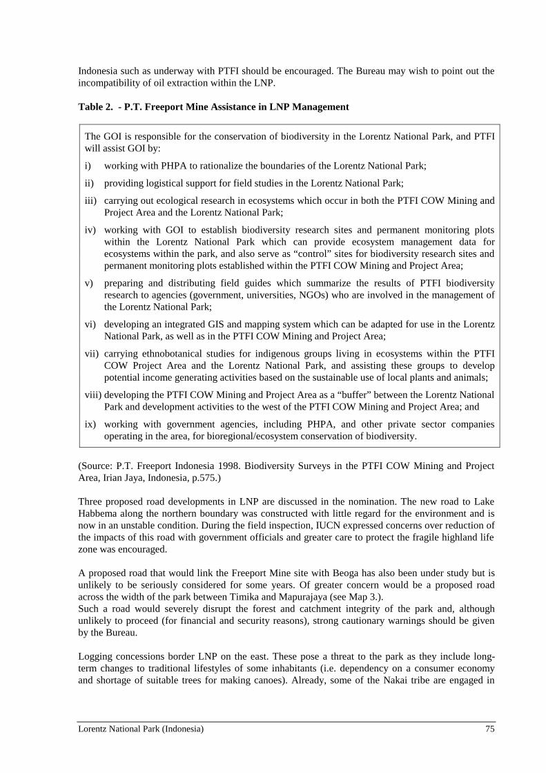
Lorentz National Park (Indonesia) 75
Indonesia such as underway with PTFI should be encouraged. The Bureau may wish to point out theincompatibility of oil extraction within the LNP.
Table 2. - P.T. Freeport Mine Assistance in LNP Management
The GOI is responsible for the conservation of biodiversity in the Lorentz National Park, and PTFIwill assist GOI by:
i) working with PHPA to rationalize the boundaries of the Lorentz National Park;
ii) providing logistical support for field studies in the Lorentz National Park;
iii) carrying out ecological research in ecosystems which occur in both the PTFI COW Mining andProject Area and the Lorentz National Park;
iv) working with GOI to establish biodiversity research sites and permanent monitoring plotswithin the Lorentz National Park which can provide ecosystem management data forecosystems within the park, and also serve as “control” sites for biodiversity research sites andpermanent monitoring plots established within the PTFI COW Mining and Project Area;
v) preparing and distributing field guides which summarize the results of PTFI biodiversityresearch to agencies (government, universities, NGOs) who are involved in the management ofthe Lorentz National Park;
vi) developing an integrated GIS and mapping system which can be adapted for use in the LorentzNational Park, as well as in the PTFI COW Mining and Project Area;
vii) carrying ethnobotanical studies for indigenous groups living in ecosystems within the PTFICOW Project Area and the Lorentz National Park, and assisting these groups to developpotential income generating activities based on the sustainable use of local plants and animals;
viii) developing the PTFI COW Mining and Project Area as a “buffer” between the Lorentz NationalPark and development activities to the west of the PTFI COW Mining and Project Area; and
ix) working with government agencies, including PHPA, and other private sector companiesoperating in the area, for bioregional/ecosystem conservation of biodiversity.
(Source: P.T. Freeport Indonesia 1998. Biodiversity Surveys in the PTFI COW Mining and ProjectArea, Irian Jaya, Indonesia, p.575.)
Three proposed road developments in LNP are discussed in the nomination. The new road to LakeHabbema along the northern boundary was constructed with little regard for the environment and isnow in an unstable condition. During the field inspection, IUCN expressed concerns over reduction ofthe impacts of this road with government officials and greater care to protect the fragile highland lifezone was encouraged.
A proposed road that would link the Freeport Mine site with Beoga has also been under study but isunlikely to be seriously considered for some years. Of greater concern would be a proposed roadacross the width of the park between Timika and Mapurajaya (see Map 3.).Such a road would severely disrupt the forest and catchment integrity of the park and, althoughunlikely to proceed (for financial and security reasons), strong cautionary warnings should be givenby the Bureau.
Logging concessions border LNP on the east. These pose a threat to the park as they include long-term changes to traditional lifestyles of some inhabitants (i.e. dependency on a consumer economyand shortage of suitable trees for making canoes). Already, some of the Nakai tribe are engaged in

76 Lorentz National Park (Indonesia)
logging activities, some of them illegal. There is currently no management presence by the ForestryDepartment in this region.
The final issue affecting integrity is the need for a more adequate management regime to be put inplace. The LNP does not have a headquarters, a resident Director or a management plan. It does havea person nominally responsible based in Jayapura and forest department rangers based in severallocations nearby but all these people have other responsibilities. A beginning has been made towardspreparing a management plan by bringing together a meeting of stakeholders but work has notprogressed since then. LNP has been largely supported to date by WWF-Indonesia with funds fromthe German and US Governments. The Government of Indonesia is intending to establish a localheadquarters and staff early next year but a capital budget to support site management has not yetbeen estimated.
A particular requirement will be for the managers of LNP to make a concerted effort to build apartnership with the local people both within and outside the park. Close liaison through the TribalCouncils, a cooperative management approach and the establishment of staff community liaisonpositions are three suggested actions. A commitment to strengthening local managerial capacity isanother high priority task.
The availability of resources for management of LNP is seen as the main issue facing the park infuture. There are proposals to establish a special foundation to independently raise funds for the park.PTFI has indicated an interest in participating in such a project as has CONOCO. The regional officesof UNESCO and WWF are both acting to facilitate the setting up of a “Friends of Lorentz” followingthe model of the Friends of Kutai National Park in Kalimantan. Completion and adoption of amanagement plan thus becomes ever more important as a means of demonstrating the commitment ofthe park authorities and establishing funding priorities.
Another proposal discussed during the field inspection is the establishment of a partnership betweenLNP and the Wet Tropics World Heritage Area in tropical Australia. Preliminary inquiries of bothagencies suggests a positive interest. Such a pairing of these two large tropical rainforest areas couldbe particularly beneficial to Lorentz in the short term and eventually should be mutually beneficial.
In conclusion, all the above issues will require a concentrated effort in the years ahead. Although LNPhas been affected by human activity along its periphery, its size and rugged terrain have helpedmaintain it in a relatively pristine state to date. With various regional pressures now mounting andwith social concerns with local residents in need of attention, the Government of Indonesia and itspartners in LNP need to take a proactive stance. The initial management planning process now needsstrong follow-up to prepare a programme of action.
5. ADDITIONAL COMMENTS The field inspection found strong levels of support for the nomination from many sectors. Inparticular, it is apparent that there is a good level of support for the nomination in the indigenouscommunities which were consulted. Notwithstanding, it is apparent that there is still a significantlevel of concern about protection of their traditional rights and questions about how the Governmentmight impact on their lives. Indigenous groups voiced the need for greater efforts by all levels ofGovernment in building trust with the local people. This needs to be addressed by a communicationprogramme by the park managers and others, including regular community liaison and information.
The official positions presented by Central and Provincial government agencies were highlysupportive of the nomination and future management of LNP as a World Heritage area. The fact thatthe nomination was signed by the President and three senior ministers was taken as a strong sign ofcommitment from the Government of Indonesia. This provides a timely opportunity to press for thiscommitment to be translated into more adequate management.
Lorentz National Park (Indonesia) 77
The non-government environmental and community welfare organisations, including the church,indicated strong support for the nomination. The Dani Tribal Council indicated support but alsoshowed some concern about possible restrictions on access to resources in their traditional lands.Again, they expressed the need for better relations with government agencies.
PTFI also indicated their strong support for the nomination. The company is already actively involvedin sponsoring social development programmes with the local indigenous programme and showsinterest in a more direct role in helping the park.
6. APPLICATION OF WORLD HERITAGE NATURAL CRITERIA All assessments conducted on the biological priorities of protected areas in Asia/Pacific by FAO,UNEP, IUCN, ADB, Conservation International, WWF as well as the Government of Indonesia, rankLNP at the top. With its size, variety of habitats and the combination of numerous additional naturalvalues, LNP is a clear candidate for inscription on the World Heritage List on the basis of thefollowing three criteria: Criterion (i): Earth’s history and geological features
The geology and geomorphology of LNP provides extraordinarily graphic evidence of major elementsof the earth’s evolution. The main mountain range is the direct product of the collision of the leadingedge of the Australian tectonic plate with the Pacific plate. Massive marine sediments, comprisingmainly limestone and sandstone, have been rapidly uplifted to produce a major cordillera, albeit ofvery recent origin. The uplift is on-going.
Whilst the graphic evidence of the plate collision is evident along the length of the island of NewGuinea, there is no doubt that Lorentz represents the most outstanding example, containing as it doesthe highest points on the mountains and the only remaining glaciers on the island. Furthermore, it isthe only intact mountains-to-sea transect on the island which has been incorporated in a protectedarea.
LNP also graphically illustrates a remarkable response to the last glacial and the post-glacial period.The main range shows all the classic evidence of glaciation, including glacial lakes and moraines.Furthermore, Lorentz retains vestigial direct evidence of the last glacial with 4 or 5 small remnantglaciers, all retreating rapidly. None of the two other tropical glacier fields in the world exhibit thefeatures of Lorentz. Indeed, there appears to be no better example of the combined effect of collisionof tectonic plates with the secondary major sculpting by glacial (glaciation) and post-glacial events(shoreline accretion). Analogues of this do extend across much of the southern side of the island ofNew Guinea but only Lorentz retains its glaciers and is in a protected area.
In response to global warming, as the glaciation of the mountains was receding, the sea level wasrising. Almost the whole of the southern lowlands of Lorentz National Park post-date the last glacialas the massive amounts of debris eroded from the mountains, including the products of glaciation,contributed to rapid accretion of the southern coastline. Most of the southern lowlands are inundatedduring high tide, both in the estuarine and freshwater zones, attesting to their very recent origin.
LNP thus meets Criterion (i) in representing a major stage of the earth’s history, in particular themountain building associated with collision of tectonic plates, overlaid with the impact of glacial andpost-glacial events, including the rise of sea level in response to global warming. Furthermore, there isan abundance of known fossil sites in the nominated area which provide a major resource recordingthe evolution of life on the island of New Guinea. Some of the fossils and fossil sites are ofinternational significance, including many now extinct New Guinea endemic species, such as theProtemnodon hopei, a large extinct member of the kangaroo family.

78 Lorentz National Park (Indonesia)
Criterion (ii): Ecological processes
The geophysical processes at work in LNP (mountain building and tectonic plate collision andaccretion of erosional materials in the lowlands) along with high rainfall have led to coincidentdevelopment of significant on-going ecological processes. LNP’s climatic gradient represents themost complete climatic gradient for the island of New Guinea, indeed for the whole of the Australiantectonic plate, from nival zones and glaciers to lowland equatorial with an equally extreme range ofplants and animal species and communities. LNP is the only protected area in the world whichincorporates a continuous, intact transect from snow cap to tropical marine environment, includingextensive lowland wetlands. The combination of these two geophysical processes, mountain buildingand coastal accretion, has created climatic and salinity gradients along which ecological processeshave sieved the regional biota in an outstandingly graphic way.
The rapid and expansive growth of the lowlands from the many parallel rivers flowing from themountains, means that the altitudinal change over much of the lowlands is minimal and is mostly at orbelow high-tide level, even in freshwater areas. The result is that tidal influence in LNP extends wellinto the freshwater areas towards the base of the mountains. The biota of the lowlands have thereforebeen sieved into a complex array of species. These occur along a salinity gradient, from mangrovecommunities in the lower estuaries, giving way upstream to nipa palm and sago palm forests which inturn give way to open freshwater swamps, freshwater swamp forest and peat forests further upstream.
The mountain building process has provided temperate refuges in the tropics for ancient Gondwanaspecies of plants during climatic warming since the last ice age. For example, LNP’s Nothofagusbeech forests are well represented, although their closest relatives are otherwise confined to the cooltemperate regions of south-eastern Australia, New Zealand and the southern Andes.
The refugial effect or local genetic evolution, or both, are manifest as local endemic species orrestricted range species. Although research to date has been limited, it is apparent for example, that anumber of mammal species, including some newly discovered species such as the Dingiso treekangaroo, have evolved to utilise the specialised habitats of the sub-alpine and upper montaneclimatic zones. The mammal fauna of the mountains is distinguished by the predominance ofmarsupials and monotremes indicating a Gondwanan origin, the Asian origin placentals being limitedto rodents and bats.
LNP provides evidence of a highly developed endemism in both plants and animals, at least for thehigher altitudes of the mountains. This is what would be expected in a region combining on-goinguplift and climatic warming.
LNP thus also meets criterion (ii) as an outstanding example of on-going ecological and biologicalprocesses in the development of terrestrial, freshwater, coastal and marine systems and communitiesof plants and animals.
Criterion (iv): Biodiversity and threatened species
Biological research in LNP to date has been very restricted and relatively little is known about thespecies composition of the area. However, research undertaken by Freeport and others in specificlocalities has been extrapolated to some extent across altitudinal zones of the LNP and confirm thatthe park supports the highest biodiversity of species in the region. The greater part of the case formeeting criterion (iv) is based on detailed information available for several montane, sub-alpine andalpine areas on the main range. Here a high level of local endemism is apparent, including manynewly discovered species.
Lorentz National Park (Indonesia) 79
Much of the rich biota of LNP is new to science and some of special interest to science. For example,the newly described tree kangaroo is of special interest given the hypothesis that it has entered on anevolutionary reversal, re-evolving from an arboreal species to a mainly ground dwelling animal. LNPcontains substantial portions of two Endemic Bird Areas with a total of 45 restricted range birds and 9endemic bird species. Two of the restricted range bird species, Archbold’s bower bird, andMacGregors Bird of Paradise are considered rare and vulnerable.
LNP, however, is a not just the habitat for many rare, endemic and restricted range species. Given thelarge size and exceptional natural integrity, it is an especially important habitat for these species andtheir on-going evolution. Given the population and development pressures that are starting to build inIrian Jaya, LNP will become increasingly important for long term conservation of the species alreadyrecorded and the many that remain to be discovered.
It is clear that LNP contains “the most important and significant natural habitats for in-situconservation of biological diversity, including those habitats that contain threatened species ofuniversal value from the point of view of science or conservation”. LNP thus meets Criterion (iv).Furthermore, given the limited knowledge on the park, it is possible to predict that further researchwill reinforce the fact that LNP is a globally important protected area for the conservation of a richbiodiversity, including many local endemic and rare species.
Criterion (iii): Superlative natural phenomena, scenic beauty
The case for this criterion has not been convincingly made in the nomination. Although there aremany scenic features in LNP such as waterfalls and the glaciers on Puncak Jaya, these features aresecondary in importance to the park’s main values under criteria (i), (ii) and (iv). Conditions of Integrity The LNP nomination meets all related Conditions of Integrity except (v) which notes that a nominatedsite “should have a management plan”. Inasmuch as the planning process has commenced with astakeholders workshop in 1997, the plan has at least been initiated. The Bureau may wish to note thatthe Government of Indonesia intends to give priority attention to completing the plan and tostrengthening the management presence in the coming year. 7. RECOMMENDATION
That the Bureau recommend to the Committee that the Lorentz National Park be inscribed on theWorld Heritage List under natural criteria (i), (ii) and (iv). The Bureau may wish to inform theIndonesian authorities of concern over a number of aspects dealing with management of the site asdiscussed above. In particular, these are:
♦ the priority need to continue the process of management planning for the park with fullinvolvement of the local stakeholders;
♦ encouragement for the proposed establishment of a Foundation which would assist in themanagement of the park;
♦ possible twinning arrangement with the Wet Tropics World Heritage site in Australia;
♦ appointment of a Park Director and support staff (as planned for 2000);
♦ the concern over development projects that would affect the park, for example the proposedTimika/Mapurajaya road and any expansion of mining activity towards the park boundary so as notto conflict with LNP’s nomination as a World Heritage Site.

80 Lorentz National Park (Indonesia)
The Bureau may wish also to commend the Government of Indonesia for acting to ensure that theformer existing mining and petroleum exploration leases in the park were withdrawn. Finally, theBureau may wish to recommend that a monitoring mission be undertaken to gauge progress threeyears after inscription.

Lorentz National Park (Indonesia) 81

82 Lorentz National Park (Indonesia)

Lorentz National Park (Indonesia) 83

84 Lorentz National Park (Indonesia)

Lorentz National Park (Indonesia) 85

86 Lorentz National Park (Indonesia)

Gran Paradiso National Park (Italy) 87
WORLD HERITAGE NOMINATION - IUCN TECHNICAL EVALUATION
PARCO NAZIONALE DEL GRAN PARADISO (ITALY)
Note by IUCN:
1. This evaluation has been undertaken by IUCN on the basis of the original nomination submittedby the State Party in 1998, in accordance with the Operational Guidelines for the Implementationof The World Heritage Convention. This evaluation is based on a field inspection carried out inMarch 1999 and review of the original nomination by expert reviewers.
2. Subsequently, a revised nomination was sent by the State Party to IUCN and this was received on9th April, 1999.
3. It was not possible for IUCN to carry out an evaluation of the revised nomination for the 1999July Bureau meeting.
1. DOCUMENTATION
i) WCMC Data Sheet: (4 references).
ii) Additional Literature Consulted: Index Seminum, 1998-1999. Description of AlpineBotanical Garden “Paradisia”. Grand Paradiso National Park, Plant list for garden; TheBirds of Gran Paradiso – F. Framarin, Gran Paradiso National Park 1996; Proceedings,2nd World Conference on Mountain Ungulates. ed. V. Peracino, several articles on ibex,Grand Paradiso National Park, 1998; Project Otter, Grand Paradiso. V. Peracino, GranParadiso National Park, Ibex Jour. Mountain Ecology, 1996é Ibex; Special Issue ofJour. Mountain Ecology on Ibex, 1993; Delle parte della Lince, ed. V. Peracino, GrandParadiso National Park, 1995; Il Parco Nazionale del Gran Paradiso! 1992: 70 Anni diStoria, di Cultura e di Ricerca Scientifica ed. B. Bassano et al. Grand Paradiso NationalPark, 1992; Le Parc National du Grand Paradis. R. Gambino et P. Saccod. Revue deGéographie Alpine, LXXIII, 1985; I. Parchi del Piedmonte, T. Bognati et al. EdizioniL’Arciere, Cuneo, 1998; Spatial interactions between wild ruminants (Alpine Ibex andChamois) and cattle on high altitude grassland. B. Bassano et al. Atti: InternationalConference on the Sustainable Uses of Biological Resources, Budapest, pp 26-29, 1996;Gran Paradiso. B. Bassano, et al, Editori Il Risveglio, Torino, 1992; Checklist de laFaune, Gran Paradiso National Park, unpublished; Large predators in the Alps: The falland rise of man’s competitors, - U. Breitenmoser, Biological Conservation 83 (3): 279-287, 1998.
iii) Consultations: 2 external reviewers, Ministry for Cultural Property and Environment,Rome; University of Turin; Director of Regional Nature Parks in Piedmonte; localofficials from Autonomous Region Vallée d’Aoste, park staff.
iv) Field Visit: March 1999. Lawrence Hamilton.

88 Gran Paradiso National Park (Italy)
2. SUMMARY OF NATURAL VALUES
Parco Nazionale Del Gran Paradiso (PNGP) (70,318ha) was established in 1922, building on anucleus of a Royal Hunting Preserve set up in 1856. This mountain park contains Gran Paradisopeak, at 4,061m, the highest mountain in Italy. There are several glaciers, glacial cirques and theevidence of past glacial history. Slopes are very steep and the penetrating valleys are narrow, thusallowing only limited alpine grassland and forest. Larch, spruce and fir forest covers about 20% ofthe nominated area. The vegetation contains some Mediterranean elements, and several rare andthreatened species occur. The build-up of wild ungulate populations and the return of species which were extirpated,particularly predators, is possibly the greatest natural value of the PNGP. Ibex were eliminated fromthe Alps, except for a small population in PNGP. This population has now increased and fluctuatesbetween 4,000 and 5,000 individuals. Through cooperation across the French border with VanoiseNational Park, seasonal migration of ibex has been assured. The Chamois now number over 8,000and red and roe deer occur at lower elevations. It is now recognised that there is a need for greaterpredation in PNGP than can be provided by its resident golden eagles, owls, fox, martens and weasels,and so the park management has been considering the reintroduction of bearded vulture, lynx andwolf. In the past few years the “re-wilding” of the area has permitted the natural recolonisation bybearded vulture and lynx, and it is suspected that the wolf has also found its way back to this area as ithas elsewhere in the Apennines and the Alps.
3. COMPARISON WITH OTHER AREAS
The nominated area is located within the Udvardy Central European Highlands BiogeographicalProvince. Though no World Heritage sites exist in this Province two nominations are currently inpreparation for the Mont Blanc area and the Aletsch Glacier region.
The Alps with a length of about 1,100km in west-east direction and an average breadth of about200km, represent one of the most extensive mountain ranges in Europe. The range can be roughlysub-divided into the Western Alps, the Eastern Alps and the Southern Alps. The nominated PNGP islocated within the High Alps,. or the inner zone of the range, which stretch from the Western Alps tothe Eastern Alps and are dominated by crystalline rocks and schist.
At present, 13 national parks are found within the Alps. In the Western Alps there are four nationalparks, three of which (Les Ecrins, Vanoise and PNGP) cover the crystalline zone of the High Alps andone (Mercantour) covers part of the crystalline zone as well as the calcareous and schist zones. In theEastern Alps there are five national parks three of which (Swiss, Stelvio, Hohe Tauern) are part of theinner zone of metamorphic rocks while two (Berchtesgaden and Kalkalpen) are part of the outer zoneof calcareous rocks. In the Southern Alps there are three national parks one of which (Val Grande) isdominated by metamorphic rocks (schist) while two (Dolomiti Bellunesi and Triglav) are dominatedby calcareous rocks.
From the aesthetic and geological point of view, the most impressive parks of the western High Alpspart are Dauphiné (in Les Ecrins National Park), Mont Blanc and Berner Hochalpen. Floral diversityand endemism are highest in the calcareous massifs of the Western and Southern Alps. Fivebiodiversity "hot spots" have been identified: the Maritime and Ligurian Alps (Mercantour, ArgenteraNature Park), the Bergamo and Trentino Alps (Adamello-Brenta Nature Park) and the Julian Alps(Triglav).
From a faunistical point of view, the PNGP is well known for saving ibex from extinction within theAlps. However, ibex is no longer considered a threatened species but has become widespreadthroughout the Alps. Ibex can be found within and outside many reserves (for example, SwissNational Park, Stelvio National Park, Berchtesgaden National Park, Hohe Tauern National Park,

Gran Paradiso National Park (Italy) 89
Allgäuer Alpen, Oberbayerische Alpen). In general, the species list of PNGP includes some rareanimals, such as the pygmy owl, capercaillie and golden eagle, but these species occur over the wholemountain range. Important populations, for example, the last autochthonous brown bear populationwithin the Alps, occur in other reserves. In conclusion, PNGP is representative of the Alps but has noparticularly unique features. It is secondary in importance to other areas of the Alps in terms ofscenery, glaciation and biological values.
4. INTEGRITY
4.1. Legislation
The legislative underpinning for PNGP is adequate and is covered by various pieces of legislation anddecrees. These are augmented by the 1991 national law on protected areas in Italy. This law providescriteria for protected areas activities relating to conservation, management, restoration, educationaland scientific research. It provides for state intervention in national parks, and allows park zoning.PNGP is using this law to control agriculture, and restore buildings and infrastructure. 4.2. Management Plan At present, a 1983 park zoning plan is being followed; this constitutes a de facto Management Plan,however, it has not been officially adopted and approved by the two Provinces and the parkcommunes. More detailed planning is currently underway which should result in a formal PNGPManagement Plan. There are urban council plans and a territorial landscape plan for the Valdotaineportion of the area. Subsidies are provided to maintain the traditional architectural character of houseswithin the park, such as the stone slates for roofs. 4.3. Transfrontier Cooperation A cooperative agreement and twinning with the Vanoise National Park (France), which abuts PNGPto the south-east, provides greater integrity, and supports joint programmes on ibex. These twonational parks, plus the adjacent Nature Reserve of Val d’Isère, form one of the largest contiguousblocks of protected area in Western Europe.
4.4. Land Ownership Land ownership is a potential threat to the integrity of the Park, with only five percent of the park areaactually under PNGP ownership (the original hunting reserve). There has, however, been a significantchange in public thinking and increasing value placed upon PNGP, including awareness of the need tocomply with regulations and guidelines. The 1991 national law on protected areas provides a strongtool which should help ensure PNGP’s integrity despite a complex pattern of land ownership. 4.5. Staffing The staff of 56 rangers are well-trained. They are mainly involved in management and monitoring offauna; including the control of poaching and loose dogs. 4.6. Visitation There are roughly 300 park guides and they receive some training. All solid waste is removed fromthe park, and litter is well controlled. Water quality is periodically monitored in the streams. Siximpressive interpretation centres (with a seventh planned) are strategically placed and help to projectto the public the park’s mission to conserve nature. 4.7. Human Use

90 Gran Paradiso National Park (Italy)
Some forestry takes place under the direction of the Forestry Department on communal and privatelands, but it is limited, partly due to the steep slopes and the need for avalanche protection. About20% of the park is covered in forest or shrubland, with much of it too steep for forest harvesting.Only 0.8% of the land is in urban or cultivated zones. Some 8,000 persons live in the various villagesin the periphery of the park; 300 more live in the protected zone. Upper alpine pastures which aresmall in extent (about 20% of PNGP) are lightly grazed in summer. The park is essentially an IUCNProtected Area Category V with an interior, high elevation Category II zone.
5. ADDITIONAL COMMENTS
Problems were experienced with the completeness of the nomination document and the authoritiessent a revised nomination document to IUCN which was received on 9 April, 1999. However, theIUCN evaluation of PNGP was carried out on the basis of the nomination sent to IUCN by the WorldHeritage Centre in 1998.
6. APPLICATION OF WORLD HERITAGE NATURAL CRITERIA
The nomination only briefly deals with geophysical criteria, biological value and cultural heritage.
Criterion (i): Earth’s history and geological features
The geophysical case and field inspection for criterion (i) is not compelling. Criterion (iii): Superlative natural phenomena, scenic beauty The case for criterion (iii) is not adequately made. Though PNGP is an area of great natural beautyand aesthetic importance, it cannot be considered outstanding even on the level of the European Alps. Criterion (iv): Biodiversity and threatened species While some justification for inscription is made on the grounds of three rare plant species, a richmammal complement (36 species) and more that 100 bird species, the biodiversity is not ofoutstanding universal value as documented, thus not meeting criterion (iv). Criterion (ii): Ecological processes The most compelling reason for inscription is for criterion (ii), but this has not been properlyaddressed in the nomination.
7. RECOMMENDATION
That the Bureau recommend that the Committee note that Parco Nazionale Del Gran Paradiso alonedoes not meet World Heritage natural criteria.
The Bureau is invited to note that World Heritage nominations are currently in preparation for theMont Blanc area and the Aletsch Glacier. The Bureau is also invited to note an initiative led by theWorld Heritage Centre to convene a regional workshop to consider the potential of the Alps region inrelation to the World Heritage Convention. IUCN considers that the PNGP should be considered asone element of a broader World Heritage Alps nomination.

Gran Paradiso National Park (Italy) 91

92 Gran Paradiso National Park (Italy)

Gran Paradiso National Park (Italy) 93

94 Gran Paradiso National Park (Italy)

Gran Paradiso National Park (Italy) 95
96 Saint Paul Subterranean River National Park (Philippines)
WORLD HERITAGE NOMINATION - IUCN TECHNICAL EVALUATION
SAINT PAUL SUBTERRANEAN RIVER NATIONAL PARK (PHILIPPINES)
1. DOCUMENTATION
i) IUCN/WCMC Data Sheet: (4 references).
ii) Additional Literature Consulted: Middleton, J. & T. Waltham. 1986. TheUnderground Atlas. 239 p; Olsen, D.M. and E. Dinerstein. 1998. The Global 200: ARepresentation Approach to Conserving the Earths Distinctive Ecoregions. WWF-US; Protected Area Management Board, Palawan. 1996. Saint Paul SubterraneanNational Park Management Plan, 1996; IUCN. 1996. Red List of ThreatenedAnimals; Davis S. et al. eds. 1995. Centres of Plant Diversity, IUCN/WWF; IUCN.1997. A Global Overview of Forest Protected Areas on the World Heritage List.IUCN; Villalon, A. 1999. Profile of National Parks in the Philippines. ProtectedAreas and Wildlife Bureau, Department of Environment and Natural Resources. QuezonCity. 174 p; Republic of the Philippines. 1991. An Act Providing for theEstablishment and Management of National Integrated Protected Areas Systems.
iii) Consultations: 5 External reviewers, relevant officials from government and nongovernment organisation in Philippines.
iv) Field Visit: J. Thorsell, January 1993; D. Sheppard and H. Friederich, February 1999.
2. SUMMARY OF NATURAL VALUES
The nominated site, the Saint Paul Subterranean River National Park (SPSRNP), is located in theSaint Paul Mountain Range. It is 81km north-west of Puerto Princesa, the capital of Palawanprovince. Palawan itself is 490km south-west of Manila (see Map 1). The SPSRNP lies within thejurisdiction of the government of the city of Puerto Princesa. The nominated site is a revision of anearlier one deferred in 1993, due to questions about inadequate size. The 1993 IUCN TechnicalEvaluation noted that, while the site was suitable for World Heritage listing, the area was too small toadequately protect its underground river watershed and to ensure the long-term viability of itssignificant biodiversity. The original 1993 nomination, of 5,753ha was thus revised, and an expandednomination of 38,753ha was put forward for consideration by the World Heritage Committee in 1998.This expansion added a 33,000ha buffer zone (hereafter called the buffer zone) to the original 1993core nomination area, which represents the boundaries of the Saint Paul Subterranean National Park,and includes a marine extension (hereafter called the core zone). The boundaries of the nominationare shown in Map 2.
SPSRNP consists of various landforms, the most impressive of which is the karst mountain landscapeof the Saint Paul Mountain Range. The topography varies from flat plains to rolling hinterlands andhills to mountain peaks. More that 90% of the park comprises sharp, karst limestone ridges aroundMount St. Paul which is itself part of a series of rounded, limestone peaks aligned on a north-southaxis, along the western coast of Palawan. The area’s natural values are significant, and have beenpreviously assessed by IUCN as meeting World Heritage natural criteria (iii) and (iv). quality. Thefocus of the area is a spectacular karst landscape containing an 8.2km long subterranean river, one ofthe most unique of its type in the world. The underground river includes many speleotherms, and

Saint Paul Subterranean River National Park (Philippines) 97
several large chambers exist, up to 120 meters in width and 60 meters in height. The limestonemountain has extensive karst features, both surface karst (pinnacles, shafts, dolines and limestonecliffs), as well as an extensive underground river system. A distinguishing feature of the river is thefact that it emerges directly into the sea, and that the lower portion of the river is brackish and subjectto tidal influences. The underground river (the Cabayugan River) arises approximately 2km south-west of Mount Saint Paul at an altitude of 100m, and flows underground for almost its entire length toan outflow into St. Paul’s Bay. All rivers and associated tributaries are within the SPSRNPnomination, which is important in relation to catchment impacts on the water quality of theCabayugan River.
Three forest formations are present: lowland, karst and limestone. Approximately two-thirds of thenomination is forested, dominated by hardwood species. The karst forest is restricted to small pocketswhere soils have developed. In the coastal area, mangroves, mossy forest, sea grass beds and coralreefs are also found. The significance of forest biodiversity within the nomination is discussed inSection 3 of this report. The Alugan Bay component of the SPSRNP has been noted by a number ofreviewers as having national significance for its mangrove forest. The faunal diversity in theSPSRNP is moderate, especially with respect to invertebrates. Endemic mammals include thePalawan tree shrew, Palawan porcupine and Palawan stink badger. Dugong have been recorded in themarine component of the park. Monitor lizard and marine turtles are also present. The PalawanPeacock Pheasant has also been recorded in the SPSRNP (recognised as an internationally threatenedspecies). The subterranean fauna has not been studied in detail, but comprises fish, prawns, snakesand insects. The tunnel and chambers of the subterranean river are home to abundant populations ofswiftlets and bats. Eight species of bats are also found in the cave, and cave swiftlets nest on some ofthe underground boulder piles. Further studies are required to determine the extent and diversity ofthe underground fauna.
3. COMPARISON WITH OTHER AREAS
St. Paul Underground River has similar geomorphological qualities as some other limestone areas inSouth and Southeast Asia, notably Gunung Mulu National Park in Sarawak, Phong Nha NatureReserve and Ha Long Bay in Vietnam, Lorentz National Park in Irian Jaya and Gomantong in EastMalaysia.
The vast majority of existing World Heritage karst sites are in temperate regions. Within the tropicalkarst region the following comparisons can be made. Ha Long Bay in northern Vietnam containssignificant karst topography and caves, in a spectacular coastal setting. This site was not nominatedon the basis of these values but the potential World Heritage significance of karst values within thesite has recently been reviewed. The caves in Ha Long Bay are mostly small in comparison to the St.Paul Subterranean River, but they do have ancillary value as they provide key evidence of changingsea levels on the Sunda Shelf. In Thailand, the Thungyai-Huai Kha Khaeng Wildlife Sanctuariescontains significant areas of lowland riverine forest and other forest types more typical of stronglyseasonal tropical climates. This property includes low-relief limestone terrain with some caves, andkarst wetlands.
The major feature of the nominated area is the 8 km underground river. There are many undergroundrivers in other karst regions around the world. For example, the Clearwater Cave and the 37 kmMelinan River in Sarawak’s Gunung Mulu National Park have arguably more significant undergroundrivers. Within the Philippines a 9 km river cave exists at Callao on Luzon. The underground river inSt. Paul is not as dramatic as similar features found in existing World Heritage sites in Slovenia’sSkocjanske Jama, Kentucky’s Mammoth Cave or the Canadian Rockies Castleguard and MaligneRiver Caves.
One feature that distinguishes St. Paul, however, is that the underground river flows directly into thesea amidst a tropical coastal setting. The underground river flowing into the sea, and the associated

98 Saint Paul Subterranean River National Park (Philippines)
tidal influence, makes this a unique feature. One reviewer also noted that St. Paul warrants specialconsideration simply because it is one of the few such rivers which the general public can easilyexperience and appreciate.
There is one other World Heritage site in the Palawan Biogeographic Province: the Tubbataha ReefMarine Park. However, this protects different values from those identified for St. Paul. Palawan is animportant biogeographic province, with a rich biota drawn from both Malaysian and Pacific sources.Palawan is distinct from the rest of the Philippine archipelago as it lies on the Sunda Shelf and hasderived most of its fauna from Borneo during recent geological times.
The biodiversity within this site is considered significant. The Palawan Moist Forest, which isrepresented within the nomination, is noted in WWF’s Global 200 report as having the richest treeflora of Asia, with high levels of regional and local endemism. The Palawan Moist Forest also has thelargest and richest examples of limestone forests in Asia. The St. Paul National Park is also noted, ina recent global overview of forested protected areas on the World Heritage List (IUCN, 1997), as aforested protected area which may merit consideration for World Heritage nomination. This wasreinforced in an expert consultative meeting on World Heritage Forests, which was held in Sumatra inDecember, 1998. This meeting considered St Pauls to be a tropical forest site of high biodiversityvalue, with high World Heritage potential. The conservation significance of this forest at theinternational level is heightened when considered in the context of the high levels of past and currentdeforestation in the Philippines and in the region. For example, the Environmental Legal AssistanceCentre (ELAC) of Puerto Princesa notes that: “in 1903, there were more than 21 million hectares offorest in the Philippines, or more than half of the country’s total area. Today, less than 6 millionhectares of forest are left. In 1994, there were only 800,000 hectares of old growth forest left”.Palawan has, in fact, been described as “the last best hope” for forest conservation in the Philippines.The role and maintenance of St. Paul takes on a special urgency in this perspective.
The marine component of the property is a small but important feature of the nomination and themangrove swamp, adjacent to the limestone hills, adds to the what is a spectacular natural setting.
In conclusion, SPSRNP has a number of features that combine to distinguish it from other areas.These include:
♦ The underground river flowing directly into the sea amidst a tropical forest setting, with itsassociated tidal influence;
♦ The forests within the nomination which are amongst the most significant in Asia, beingrepresentative of Palawan Moist Forest, and which have been identified in a number of expertreviews as having World Heritage potential; and
♦ The fact that this is the most important sites for conservation in the Palawan BiogeographicProvince.
♦ The coverage of a complete “mountains to the sea ecosystem”, within the nomination

Saint Paul Subterranean River National Park (Philippines) 99
4. INTEGRITY
4.1. Boundaries
The nomination document notes that: “Designating the original 5,753 hectares of Park area as thecore area, to assure its protection, an additional buffer zone area of approximately 33,000 hectareswas added to the Park”. This area is shown in Figure 2 and, as noted, covers the boundaries of sixBarangays (Barangay is an administrative boundary for local purposes). The nomination alsoincludes freehold land.
There are two relevant points which were reinforced by the 1999 field inspection. First, the reasonfor the deferral of the original nomination was to ensure adequate protection of the catchment of theunderground river, and thus ensure protection of the natural values, particularly those related to waterquality and quantity of the underground river. This river and its tributaries are all within theBarangay Cabayugan. This is thus the critical area for protecting any potential World Heritage valuesin the nomination. The adjoining Barangay Marufinas also has important biodiversity values,particularly for forest conservation. The natural values of the other Barangays, while still important,are less significant in the context of potential World Heritage, as these areas are not essential for theprotection of the catchment values of the subterranean river, and are less important for biodiversityconservation. IUCN thus considers that the boundaries of the nomination should be confined to thecore area of the park and to the two immediately adjacent Barangays (Cabayugan and Marufinas).The total size would thus be approximately 20,000ha, rather than the current nomination of 38,753ha.Any revised nomination boundary should exclude freehold land.
It should be noted also that Ulugan Bay, while considered by IUCN to not be of World Heritagestatus, is very important for mangrove conservation, at a national level. This significance should berecognised, possibly through designation as a Ramsar site, if agreed by the State Party.
Second, the nomination notes that consultation with key stakeholders within the nominated areaoccurred in December, 1997. However, the field inspection noted a lack of clear agreement byrelevant Barangays to the inclusion of lands within the nominated area as World Heritage. On thesegrounds, it is thus recommended by IUCN that the nomination be referred back to the Philippinesauthorities for amendment of boundaries to include only the area which has been noted above as mostimportant for the protection of the catchment of the underground river and for biodiversityconservation. Also, IUCN recommends that the proposed World Heritage nomination boundary beagreed upon by the two Barangays and this should be confirmed in writing when the revisednomination boundary is submitted to the World Heritage Centre.
4.2. Legal Status The previous IUCN review recommended deferral until a legal definition of boundaries is available.Clear legal protection of natural values is essential before the area could be considered for WorldHeritage listing. This is not the case yet, and IUCN therefore notes this as an addition point justifyingreferral back to the State Party. IUCN also notes that the legal owner of the Park is the City Government of Puerto Princesa, by virtueof the Memorandum of Agreement (MOA) for Devolution, between the City Government and theNational Government. Under this MOA, the City Mayor is the authority with full responsibility overthe property and all management decisions for the Park are made by the Mayor in consultation withthe Protected Areas Management Board (PAMB). This agreement means that the area is protected ata local rather than a national level. This arrangement appears to have worked effectively to date,largely reflecting strong support at the local political level, particularly from the City Mayor. If thisarea is inscribed as a World Heritage site, IUCN considers it important that the status of natural

100 Saint Paul Subterranean River National Park (Philippines)
values is monitored effectively over time, to ensure that these values are not compromised by anychange in local management perspectives which may occur in the future. 4.3. Management Management can be considered at two levels: the core zone and the buffer zones. Management of thecore zone (comprising the Park) is currently very effective, reflecting strong local political support aswell as reasonable funding and staffing levels. Funds raised from tourists visiting the site areincreasing and earnings are deposited into a trust fund, with expenditures from the proceeds allocatedfor park management purposes. St. Paul is the only National Park in the Philippines that earns anincome from fees in this way. Staffing levels are adequate but more training in park planning andmanagement is required. Current park management builds on the foundation of earlier work,particularly that started when the park became the subject of an internationally financed Debt-for-Nature Swap Programme in 1989, through WWF – The World Wide Fund for Nature. There is a management plan for the Park which sets out relevant objectives and programmes to ensureeffective management of the Park. The plan provides for zonation within the park boundaries. IUCNconsiders the management plan for the park to be a professional document, but more resources arerequired in order to fully implement the plan. Management of the buffer zone is covered by management guidelines which seek to regulate activitiesto minimise impact on the core zone. These guidelines are presently being prepared by the PAMBwith the assistance of the European Council-Palawan Tropical Forestry Programme (EC-PTFPP),which aims to establish sustainable protective measures for the agricultural land within the bufferzone. It further aims to introduce protective measures that conserve natural resources and improve thequality of life of the area’s residents. IUCN considers that the existing management plans for the corezone and the management guidelines for the buffer zone should be consolidated and harmonised, inorder to effectively protect the catchment of the underground river. It is noted that suchharmonisation is underway at present and this is to be commended. 4.4. Threats
There are several threats to the core zone of the SPSRNP from activities in the adjacent catchmentarea. The main threats are from forest clearing and agricultural activities. Tourism in the area, if notcarefully planned and implemented, also has great potential to adversely impact on the natural valuesof the core zone. At present, tourism is at low level although it is increasing. Tourism managementobjectives for the Park are set out in the management plan and these appear relevant and effective. Itis important that a tourism development strategy be developed for the entire nomination, (core andbuffer zone) which enhances visitor appreciation of nature while protecting natural values. Waterquality in the underground river is invariably affected by upstream agricultural activities in thecatchment area. Evidence of these activities was witnessed by the IUCN mission team in 1999.There is need for the previously mentioned management guidelines to cover issues such as removal ofpollution inputs to the river.
5. ADDITIONAL COMMENTS
5.1. Regional Integration The nominated area demonstrates the importance of integrated regional planning, if core WorldHeritage values are to be protected. It is noted that all of Palawan is covered by an IntegratedConservation and Development Plan. Within the nomination, the Palawan Forestry ProtectionProgramme is currently addressing many of the issues mentioned above, within the buffer zone.

Saint Paul Subterranean River National Park (Philippines) 101
5.2. Cultural Heritage St. Paul Cave was known to local people since ancient times, in their thoughts it was inhabited by aspirit that prevented them from entering the cave. The park’s territory and surroundings are theancestral lands of the Batak and Tagbanua communities. The needs of the local communities arebeing considered through the preparation of the previously mentioned management guidelines. 5.3. Ulugan Bay
This area is located within the nominated area, and it comprises mangrove forests in variousconservation states. It has been estimated that 15% of the mangroves in the Philippines are in UluganBay. Possible threats to Ulugan Bay from a proposal to establish a Naval base were also noted by theIUCN mission. This area is considered nationally significant and IUCN considers that it may besuitable as a Ramsar site. This should be considered by the State Party.
6. APPLICATION OF WORLD HERITAGE NATURAL CRITERIA
The SPSRNP is nominated under three natural criteria. The previous IUCN evaluation report in 1993noted that the site: “meets two natural criteria: criterion (iii) as a site with a spectacular karstlandscape including its underground river and caves, and criterion (iv) with its habitat for many rareand endemic species.” This evaluation report reinforces the 1993 evaluation and notes the followingin relation to the three natural criteria under which the SPSRNP was nominated.
Criterion (ii): Ecological processes
The SPSRNP provides examples of important on-going ecological processes. IUCN considers thisimportance to be of regional rather than international significance and considers that this nominatedsite does not meet natural criterion (ii).
Criterion (iii): Superlative natural phenomena, scenic beauty
The Saint Paul Mountain Range features a spectacular limestone karst landscape. The undergroundriver, flowing into the sea, and its associated tidal influence, make this a significant naturalphenomena. IUCN considers that the nominated site meets criterion (iii).
Criterion (iv): Biodiversity and threatened species
The nominated area represents a significant habitat for biodiversity conservation. The SPSRNPcontains a full mountain to the sea ecosystem and protects the most significant forest area within thePalawan Biogeographic Province. IUCN considers the nominated area meets natural criteria (iv).
7. RECOMMENDATION
That the Bureau note the Saint Paul Subterranean River National Park site is considered by IUCN tomeet natural criterion (iii) and (iv). However, IUCN recommends that the nomination be referredback to the state party for amendment and legal definition of boundaries so that they include the areamost important for the protection of the catchment of the underground river and for biodiversityconservation, as outlined in Section 4.1 of this report. IUCN also recommends that the revisedboundary be agreed upon by the two Barangays, and that this be verified by the State Party.

102 Saint Paul Subterranean River National Park (Philippines)

Saint Paul Subterranean River National Park (Philippines) 103

104 Saint Paul Subterranean River National Park (Philippines)

Saint Paul Subterranean River National Park (Philippines) 105

106 The Laurisilva of Madeira (Portugal)
WORLD HERITAGE NOMINATION - IUCN TECHNICAL EVALUATION
THE LAURISILVA OF MADEIRA (PORTUGAL)
1. DOCUMENTATION
i) IUCN/WCMC Data Sheet: (10 references).
ii) Additional Literature Consulted: United Nations List of National Parks and ProtectedAreas. 1985; Heywood. 1994. Centres of Plant Diversity. Vol. 1. IUCN/WWF; TheEuropean Committee for Conservation of Bryophytes. ed. 1995. Red Data Book ofEuropean Bryophytes; Thorsell, J. & T. Sigaty. 1997. A global overview of forestprotected areas on the World Heritage List. IUCN; Santos, A. 1990. EvergreenForests in the Macaronesian region. (Council of Europe); Synge, H. 1991. WhichOceanic Islands merit World Heritage Status? A short feasibility study for IUCN.
iii) Consultations: 8 external reviewers, Government officials in Lisbon, Madeira andCanary Islands and members of IUCN-SSC Macaronesian Island Plants Specialist Group.
iv) Field Visit: February 1999, Hugh Synge.
2. SUMMARY OF NATURAL VALUES
The nominated site, The Laurisilva of Madeira (LM), consists of approximately 15,000ha within the27,000ha Madeira Nature Reserve. The nominated site conserves primary laurel forest or "laurisilva",a vegetation type that is now confined to the Azores, Madeira and the Canary Islands. The laurisilvaon Madeira is the largest area of laurel forest surviving (see comparisons, next section) and is in verygood condition, with around 90% believed to be primary forest.
The laurel forest has great ecological value, playing an important role in maintaining the ecologicalbalance of the island. It provides ecological services to the island by protecting the micro-climate andmaintaining water supplies by collecting and retaining water.
The forest completely covers a series of very steep, V-shaped valleys leading from the plateau andeast-west ridge in the centre of the island to the north coast. Ancient trees in the valley bottoms,waterfalls and cliffs provide the visitor with an experience not found elsewhere in Europe, and morereminiscent of an African montane forest than a part of Europe. At the higher altitudes, arborescentplants in normally herbaceous genera such as sow-thistle cling to steep cliffs, again reminiscent of theAfrican mountains, and in the valley bottom giant ferns abound.
LM is notable for its biological diversity with:
♦ At least 66 vascular plant species endemic to Madeira occurring in the site;
♦ Of its large bryophyte flora, 13 liverwort species and 20 moss species are listed as rare orthreatened on a European scale; and

The Laurisilva of Madeira (Portugal) 107
♦ Endemic animals including a species of pigeon (The Madeiran Long-toed Pigeon, which eats thelaurel fruits); a lizard species; two species of bats; and endemic subspecies of chaffinch andfirecrest.
3. COMPARISON WITH OTHER AREAS
Fossil evidence shows that laurisilva once covered much of Southern Europe in the Tertiary era, 15-40 million years ago, and what is now seen in Madeira is the largest surviving relict of a virtuallyextinct flora of great interest. As climate change brought about its demise on continental Europe, theocean- moderated climate of the island groups of the Azores, Madeira and Canary Islands maintainedrelicts of this previously widespread forest type.
While there are other areas of evergreen forest influenced by coastal fog, such as on the westernseaboard of North America and temperate South America, all have completely different biota. Theforest of LM is similar in structure, but not in species, to the montane forest of East Africa.
The relict laurisilva areas are in the Macaronesian Islands Biogeographic Province and, as stated by areviewer, "The Macaronesian forests are unique in their phytogeographical history and in the relictand endemic species they contain." The main comparison is therefore with the other areas of laurelforest in the Azores and Canaries:
The laurel forest in the Azores (Portugal) is less rich in species than that of Madeira and the Canaries,and is reported to be rather degraded.
The Canary Islands (Spain) contain laurel forest on the central and western islands, with the mostsignificant being on La Gomera, where the laurel forest is protected in the Garajonay National Park of3,948ha of which 70% is laurel forest. This was inscribed on the World Heritage List in 1986. Theevaluation report for Garajonay reports that that park contains over half of the Canarian laurel forest.The key comparison therefore is between the Madeiran laurisilva and Garajonay National Park.There are differences:
The laurisilva in LM is much larger: covering some 15,000ha as opposed to just c 3,000ha in theGarajonay site. The topography is different: the Madeiran forest is on steep V-sided valleys runningfrom the central ridge and plateau to the north coast, from 1,400m to sea-level. Garajonay is aneroded volcanic plateau with a central crater and gently sloping escarpments, the park being at 600-1,492m. The Madeiran forest is in general more luxuriant than the Canarian forest, being taller,wetter and cooler. In the lower areas there are large ancient Ocotea trees of up to 40m high, a featurenot present in the Canary Islands where the forest is much lower and more shrubby in nature.
Although the four dominant species of trees are the same in both LM and Garajonay, most of the restof the flora is different. The Madeiran forest has numerous rare and endemic species, especially ofbryophytes, ferns and flowering plants. It also has a very rich invertebrate fauna which is only justbeginning to be uncovered.
The biological value of LM is recognised by its designation as a Special Area of Conservation (SAC)under the EU Habitats Directive, specifically for the conservation of a priority habitat type and 38named threatened plants and animals. Few other sites in Europe have so many listed species. It isalso one of the Centres of Plant Diversity identified in a global WWF/IUCN project and is givenspecial emphasis as an area of high bryophyte diversity in the Red Data Book of EuropeanBryophytes.
When the Spanish nomination of Garajonay National Park was evaluated by IUCN in 1986 it wasseen as "the singularly most unique protected area in all of Spain for the international significance ofits endemic flora... and as the only major remnant of a once common ecosystem.” The 1985 United

108 The Laurisilva of Madeira (Portugal)
Nations List of National Parks and Protected Areas confirmed this view in relation to Macaronesianforests. Garajonay was inscribed on the World Heritage List under two criteria as "an outstandingexample of biological evolution of the laurel forest ecosystem" and as a site with "habitats of rare andendemic plant species..."
It is significant that the 1985 UN List did not record any protected areas on Madeira. This reflectsthat, in the 1970s, the Canarian laurel forest was well known and publicised but little information wasavailable on the Madeiran forest. It was in the mid 1980s that the Madeiran laurel forest was deemedso important for plant conservation, that it was chosen as the site for one of the 20 or so field projectsdeveloped around the world in the IUCN/WWF Joint Plants Conservation Programme. Conservationactivity for the LM dates from the 1990s, following among other things an IUCN study funded by theInternational Dendrology Society and a field visit by WWF in 1990.
An IUCN study in 1991 on which oceanic islands merit World Heritage status, it was noted thatislands have in general been neglected in conservation yet contain floras of extreme importance andvery high numbers of threatened species: one in three of all threatened plants occurs on islands.
When oceanic islands were ranked in terms of the number of endemic plant species, Madeira placedat number twenty. However, many of those ranked above it are very much larger, such as NewCaledonia and Jamaica while others, such as Mauritius, have floras degraded by invasive introducedspecies. In fact, the Madeiran laurisilva is much the largest extent of laurel forest surviving in theworld, with a unique suite of plants and animals. It would be hard to think of any plant-rich oceanicisland of similar size as Madeira that has such a high proportion (close to 90%) of its natural forestintact.
4. INTEGRITY
The boundaries of the proposed World Heritage site include the primary laurisilva that remains onMadeira. There was an exhaustive field study of the laurisilva from 1992 to 1995. The members ofthe team that implemented the study now form the core staff of the Nature Park.
The site contains no habitation, no buildings (except the occasional tiny hut for those who maintainthe levadas - see section 5.) and no cultivated land.
The LM is all primary forest except for the two easterly portions (roughly 10% of the whole),believed to have been cut some 40-50 years ago but which are now recovering well. The main forestis believed never to have been felled or cut and includes some massive old trees, believed to be over800 years old, before the island was settled. Goats and sheep, which caused some damage in the past,have now been eliminated from the park, but stray animals are occasionally found there.
4.1. Legislation
LM is protected under a range of designations. It is one of the first accepted SACs under the HabitatsDirective of the European Union. This directive has the force of law in EU Member States obligingPortugal to protect the area so that both "Madeiran laurel forest" and 38 species of rare and threatenedplants and animals remain at, or are restored to, "favourable conservation status". Member Statessuch as Portugal, may receive substantial grants from the EU LIFE fund to enable them to meet thisobligation but if they fail the European Commission has the power to take them to the European Courtof Justice. The site is also a Biogenetic Reserve of the Council of Europe.
Conservation functions are devolved to the Autonomous Regional Government of Madeira, which iselected by the island people. Under Madeiran law, the proposed WH site is gazetted partly as a StrictReserve ("Reserva Integral") and partly as a Partial Reserve, about half in each. Strict Reservecorresponds with IUCN Category Ia, as no access is permitted except for conservation purposes.

The Laurisilva of Madeira (Portugal) 109
Partial Reserve corresponds with IUCN Category II, since ecosystem protection is the main objective;visitor access is allowed and some very small cutting of the common tree heather in the higher zonesis also permitted for local people, who use it to fence their terraces; this use is declining and appearsto do no harm to the forest.
4.2. Boundaries
The whole site is enclosed within the Madeira Nature Park, which was established around 1990 as alarge Category V site. However, the emphasis of management is almost entirely on the laurisilva,which is managed as Category I and II. Indeed, Park boundaries were drawn widely, including manyareas of regrowth and introduced Eucalyptus on the southern slopes of the island. A redrawing of theboundaries of the Nature Park is under way to exclude much of this area from the Nature Park but thiswill have no negative effect on the site nominated. The authorities also plan to upgrade the protectionfor the Nature Park at the same time.
4.3. Adjacent area
No integrity problems are foreseen from areas surrounding the nominated site. Higher altitude areasare grassland and juniper managed for conservation and there appears no future threat from exoticspecies as pressure grows for any future plantation forestry to use native species. However,compatible management of these areas will be important for LM.
4.4. Agriculture
Below the laurel forest, in areas where the forest does not end in steep sea cliffs, are traditionalagricultural terraces. The extent of these is shrinking as young people leave the villages to work inhotels on the south coast and laurel forest is starting to reclaim part of the area. One danger is ofinvasive species from these terraces but under a project funded by the EU LIFE-Nature Fund, a teamis removing all tubers of the ornamental ginger from the terraces. This is a precautionary measure toprevent invasion of the laurisilva.
4.5. Access
The site is presently bisected by two roads running north south. One which cuts through Ribeiro Friois an old route and serves a Forest Station with a botanic garden of endemic species. The other roadto a large excluded area south of Sao Vicente is being replaced by a tunnel that will mean vehicles donot enter the proposed World Heritage site. Along the western part of the north coast, where theproposed site reaches the coast, the coast road forms the boundary of the site, mostly cut intoprecipitous cliffs. There are a few tracks through the forest used for access to the forest and tomaintain the levadas (see section 5) but not for tourist access.
4.6. Visitation
Visitation does not seem high, despite the growth of tourism on Madeira, which now has 18,000tourist beds, scheduled to rise to a ceiling of 24,000. Facilities for visitors to the laurel forest are fewand clearly this is a subject to which management will need to give priority. With the sheer cliffsbeside narrow levadas, great care will need to be taken both to protect the forest and to provide forvisitor safety, as pressure for access mounts. World Heritage status may encourage more visitors butshould also help safeguard the site against the temptation of building inappropriate facilities forvisitors.
In conclusion, the proposed site is well protected and all threats, except visitor pressure, seem to bediminishing not increasing. The Nature Park administration has done a good job in building up theprotection of the site in a short time, through a complex set of overlapping designations, national and

110 The Laurisilva of Madeira (Portugal)
international, and by work on the ground. Thanks to the 1992-5 survey, they have a remarkableknowledge of the site on the ground. The challenge is now to consider more closely the issues ofinterpretation, which appears lacking, and visitor access.
The LM is considered to meet the conditions of integrity.
5. ADDITIONAL COMMENTS
The settlers of Madeira constructed levadas, water channels through the forest that follow thecontours clinging to the cliffs and steep-sided valleys. Typically 80-150 cm wide and constructed ofstone or more latterly concrete, they carry water from the forest to hydropower stations and to thetowns of the south, where they provide essential drinking water and irrigation supplies. To getthrough the central ridge, tunnels as long as 5km were constructed. Besides the levadas, including inthe tunnels, are paths typically 1-2m wide, which allow access to the otherwise almost impenetrableforest. There is much interest in Madeira in nominating the levadas for cultural status on the WorldHeritage list, but they are not on the indicative list for Portugal. As far as nature conservation isconcerned, they are a benefit, since they allow access to the forest on relatively flat paths and coveronly an infinitesimal area of land. None has been built for 50 years, but the present ones are carefullymaintained.
6. APPLICATION OF WORLD HERITAGE NATURAL CRITERIA
The site is nominated under all four natural criteria.
Criterion (i): Earth’s history and geological features Criterion (ii): Ecological processes
IUCN does not consider that the geology of the nominated site meets criterion (i).
Criterion (ii): Ecological processes
In parallel with the Garajonay National Park (Spain), LM is an outstanding relict of a previouslywidespread laurel forest type. LM is considered to fulfil criterion (ii).
Criterion (iii): Superlative natural phenomena, scenic beauty
Although the site is attractive, in IUCN’s assessment, it does not qualify under criterion (iii).
Criterion (iv): Biodiversity and threatened species
The greatest natural value of the laurisilva is its biological diversity. Nearly all its plants and animalsare unique to the laurel forest. The Madeiran laurisilva is not only larger but has differencesbiologically from laurel forest elsewhere. It therefore meets current Criterion (iv) as containing "themost important and significant natural habitats for in-situ conservation of biological diversity."
Along with the existing Garajonay site, LM would give excellent coverage of laurel forests on theWorld Heritage List. However, the fundamental similarities between the two sites located in the sameAtlantic region suggest the logic of the relevant States Parties being encouraged to consider seekinginscription of the Laurel forest of Madeira along with the Garajonay National Park as an internationalWorld Heritage site representing the once widespread laurel forest ecosystem.
7. RECOMMENDATION
That the Bureau recommend to the Committee that the Laurel Forest of Madeira be inscribed on theWorld Heritage List under natural criteria (ii) and (iv).

The Laurisilva of Madeira (Portugal) 111
The Bureau may also wish to compliment the State Party on the protection afforded to the forest in aprotected area less than 10 years old and the commitment shown by the Autonomous RegionalGovernment. At the same time, the Bureau may wish to draw attention to the potential for enhancedinterpretation of the area and for compatible forestry practices outside the site.
Finally, the Bureau may also wish to encourage the Portuguese authorities to discuss with the Spanishauthorities the possibility of their jointly proposing Garajonay National Park World Heritage site andthe Laurel Forest of Madeira as a single World Heritage site representing laurel forest.

112 The Laurisilva of Madeira (Portugal)

The Laurisilva of Madeira (Portugal) 113

114 The Laurisilva of Madeira (Portugal)

The Laurisilva of Madeira (Portugal) 115

116 Western Caucasus (Russian Federation)
WORLD HERITAGE NOMINATION - IUCN TECHNICAL EVALUATION
WESTERN CAUCASUS (RUSSIAN FEDERATION)
Regrettably, an IUCN Technical Evaluation Report of this nomination is not available for the JulyBureau meeting. The State Party requested that a field mission be delayed for climatic reasons. TheIUCN evaluation mission will take place in June 1999 and a report will be prepared for the Novembermeeting of the Bureau.
IUCN. May 1, 1999.

The Laurisilva of Madeira (Portugal) 117

118 Greater St. Lucia Wetland Park (South Africa)
WORLD HERITAGE NOMINATION - IUCN TECHNICAL EVALUATION
GREATER ST. LUCIA WETLAND PARK (SOUTH AFRICA)
1. DOCUMENTATION
i) IUCN/WCMC Datasheet: (no references)
ii) Additional Literature Consulted: Lubombo Spatial Development Initiative. n.d. 44p.;Bird, E.C. 1968. Coasts. MIT Press; Heydorn A.E.F. 1989. The Conservation Status ofSouthern African Estuaries, in Huntley, B.J. Biotic Diversity in Southern Africa.O.U.P.; Hockey P. and C.D. Buxton. 1989. Conserving Biotic Diversity on SouthernAfrica’s Coastline in. ibid; Hughes, R.H. and J.S. Hughes. 1992. A Directory of AfricanWetlands. IUCN/UNEP/WCMC; Begg, G. 1978. The Estuaries of Natal. Town andCountry Planning Commission. Natal. 657p.; Sheppard C. and S. Wells. 1988. CoralReefs of the World. Vol.2. IUCN/UNEP; MacKinnon, J. & K. 1986. Review of theP.A. System in the Afrotropical Realm. IUCN/UNEP; Stuart S. et al. 1990.Biodiversity in Sub-saharan Africa. IUCN. 242p.; Ramsar Convention. 1992. St. LuciaSystem. Monitoring Procedure Report 28; Ramsar Bureau. Various dates. InformationSheets on Ramsar Wetlands in South Africa; Davis S. ed. Centres of Plant Diversity.Vol1. IUCN/WWF; Taylor, R.H. 1993. Proceedings of the Workshop on WaterRequirements for St. Lucia. Dept. Environmental Affairs, 83p.; Kyle, R. 1999. Factsheeton Resource Utilisation in Kosi Bay. KZDNC. 12p.
iii) Consultations: Federal and Provincial Park Agency representatives
iv) Field Visit: January 1999. Jim Thorsell.
2. SUMMARY OF NATURAL VALUES
The Greater St. Lucia Wetland Park (GSL) is located along the north-eastern coast of Kwazulu-NatalProvince in South Africa. The park system extends from the Mozambique border for almost 220kmsouth to Cape St. Lucia. Width of the land portion of the coastal strip varies from 1 km to 24km. Amarine reserve component 5km wide extends 155km along the length of the coast. The GSL consistsof 13 separate but contiguous conservation units totalling 239,566ha. The area has a subtropicalclimate affected along the coast by the Agulhas oceanic current. A number of river systems flow intothe park and have their catchments outside GSL in the Lubombo Mountains. A rich source of marinefossils occur in upper cretaceous sediments that help explain the Gondwana relationships of the site.Five ecosystems are found in GSL:
♦ the marine ecosystem characterised by a warm sea, the southernmost extension of coral reefs inAfrica, submarine canyons and long sandy beaches;
♦ the coastal dune system consisting of linear dunes up to 183 m in height, sub-tropical forests,grassy plains and wetlands;
♦ lake systems consisting of 2 estuarine-linked lakes (St. Lucia and Kosi) and 4 large freshwaterlakes;

Greater St. Lucia Wetland Park (South Africa) 119
♦ the Mkuze and Mfolozi swamps with swamp forest, extensive reeds and papyrus wetlands; and
♦ the inland western shores with ancient shoreline terraces and dry savanna woodland. Apart from the variety that each of these ecosystems provide to the GSL, the many ecological linkagesbetween them have been a major attraction for research on the geomorphological and biologicalprocesses that occur there. Four RAMSAR sites are included in the GSL. Associated with this high environmental heterogeneity is a remarkable diversity of natural biota. Thisis reinforced by the transitional location of GSL between the tropical and subtropical African biotaand its setting within the Maputuland Centre of Endemism. The flora of GSL is diverse with 734genera and 44 endemics recorded within its mosaic of forest/grassland/wetland and marine vegetation.The marine component is rich in species as well with 53 corals, 812 molluscs and 991 reef fishes.GSL provides home to 50 species of amphibians, 109 species of reptiles, including several that areendemic or threatened. It is also the principal southern African breeding ground of the loggerheadand leatherback turtles. Birdlife is especially diverse with 521 species and the park is a majorbreeding area and refuge for migratory waterfowl and waders. GSL is also known for 97 terrestrialmammal species and 32 marine mammals including dolphins and whales. Threatened species foundin GSL (as listed under the CITES Convention) total 147. 3. COMPARISON WITH OTHER AREAS There are currently 42 sites on the World Heritage list with major wetland values and 40 others thatcontain secondary wetland values. 40 existing World Heritage natural sites have a coastal and marinecomponent. In Africa, the only World Heritage site comparable to GSL is the Banc d’Arguin inMauritania which contains sandy marine and estuarine waters but does not have freshwater habitats orcoral reefs. The same is true of the Arabian Oryx Sanctuary in Oman as well as the Shark Bay site inAustralia, El Vizcaino in Mexico and, to a lesser extent, Donaña in Spain. None of these have thesame terrestrial species complement as St. Lucia which among others has megaherbivores such asrhino and hippo and predators such as leopard. GSL has some similarities with the Fraser IslandWorld Heritage site in Australia which has significant coastal sand dune features as well as diversemarine life including turtles, dolphins, whales and abundant fish and marine invertebrates. GSL,however, is distinct terrestrially with its range of saline and freshwater wetlands, estuaries,floodplains and savanna. Within southern Africa, the St. Lucia system extends into Mozambique as far as the Inhaca Peninsulawith swamps, freshwater lakes and coastal lagoons. (The nomination documentation notes that,recognising its transfrontier nature, an extension of the site is being discussed with the Mozambicanauthorities.) There are other freshwater lagoons and estuaries further north along the Mozambiquecoast (e.g. Inharrime R.) but these do not have the range of natural values of GSL and are notadequately protected. Other important coastal wetlands in the region are found at Walvis Bay, CapeCross and Sandwich Harbour in Namibia but these are arid systems without the range of ecosystemsand biota as found in GSL. Within the South African Woodland/Savanna Biogeographical Province there are 389 protected areas,many of large size such as Kruger, Hwange and the Okavango complex. All of these sites are inlandand do not include the significant coastal features of GSL. Finally, along the South African coast itself, there are almost 50 coastal conservation areas (see map),one of which (Cape Peninsula National Park) is being considered for World Heritage nomination.GSL, however, is very distinctive from all of these in that it is the largest estuarine system in Africa,the most diverse and the only area with coral reefs and with such a high number of threatened species.
Distribution of coastal conservation areas between the Orange River and Kosi Bay.

120 Greater St. Lucia Wetland Park (South Africa)
(Reserve names, sizes and conservation status are detailed in Table 1 in Hockey andBuxton, 1989.)
4. INTEGRITY The area has a history of conservation management dating back to 1895 when the first reserves werecreated by the Zululand Government. The major threat to the area was a sand mining proposal whichwas resolved by the South African Cabinet in 1996. After lengthy public debate the decision wasmade to not approve titanium mining anywhere in GSL and to nominate the area for World Heritagestatus. The following issues relating to integrity of GSL, however, remain. 4.1. Protection of catchment area and regional development All estuaries exist in a state of dynamic equilibrium and are places of constant interaction betweenhumans and sea. As experience in other World Heritage wetlands has shown, human-induced changesin upstream catchments can have significant effects. Changes that have affected the GSL includeupstream water abstraction, agricultural practices and road construction. These issues were addressedin a 1992 Workshop on Water Requirements for Lake St. Lucia and will be an on-going concern asdevelopment in the catchment area continues. Recognising the economic, social and environmental linkages in the region around the GSL, theGovernment of South Africa, Mozambique and Swaziland have initiated the Lubombo SpatialDevelopment Initiative (LSDI). This exercise in tri-lateral regional planning will provide anothermechanism for addressing GSL’s catchment issues. The GSL World Heritage nomination is thus seenin a larger context of integrated development and a regional plan and Environmental ManagementFramework are now being prepared. 4.2. Management Structure

Greater St. Lucia Wetland Park (South Africa) 121
Recognising the need for integration of the GSL with the LSDI and the complexity of managing the13 component units of the nomination, the national and provincial levels of government areestablishing a statutory authority for the Greater St. Lucia region. This Authority will provide amechanism to consolidate the various conservation units under a single legal designation.Importantly, the Authority will assign management to the Kwazulu-Natal Nature ConservationService which IUCN recognises as one of the world’s most effective protected area managementagencies. 4.3. Land Claims Much of the land in the GSL is under negotiation as part of the work of the Commission onRestitution of Land Rights. Settlement of the land claims are expected to be announced soon. It isexpected that these settlements will be compatible with protecting the conservation status of the areabut could possibly result in boundary changes in the peripheral and buffer areas. The Bureau shouldnote that its decision on this nomination should not prejudice the land claim negotiation process. 4.4. Resource Harvesting and Local Community Issues Parts of the GSL are managed to allow controlled extraction of some natural resources (i.e. IUCNProtected Area Category IV). This is an important source of revenue and subsistence by people whoare neighbours of the park for these resources are difficult to obtain outside the park. For example,commercial fish off-take from Lake St. Lucia is about 14,000 tons per year. In the Kosi lake systemuse is even more intense with monitoring reports for 1997 indicating that a wide range of products areharvested. An average daily number of 488 local people use the area and gather products totalling 1.6mil. Rand in annual value. Close monitoring suggests that most of this use was legal and sustainableand most of it is for subsistence purposes. Other products harvested is ncema grass and reeds. Some1500 people per day are allowed to collect this for a two-week period each June. Other permits toindividuals of local tribal groups also allow to harvest marine invertebrates and thatch. Wild-laidcrocodile eggs are also collected on a controlled basis. All of the above human uses of GSL are subject to intensive management, research and monitoring.They are also confined to about a third of the total area while the remainder is free from extractiveuses. With some 100,000 people in 48 tribal groups surrounding the GSL, the communityconservation programmes in place are key to minimising conflicts and maximising benefits. In thisregard, some funds to assist in community conservation have come from WWF but budget allocationsfrom the Province need to ensure GSL management is adequately supported. 4.5. Restoration of degraded habitats Like most protected areas, GSL has some problems with exotic species, including some plantationforests. Many actions are underway to control this problem but, once again, continued support fromgovernment is required. Active intervention to dredge the St. Lucia estuary is also an on-goingmanagement expense. 4.6. Boundary changes As the nomination notes, there is action underway to establish a transfrontier site with neighbouringMozambique as well as extend the marine reserve to align with the terrestrial component for the fulllength of the GSL. Both these initiatives are commendable and would benefit conservation of thearea. Further additions as a result of the land claim negotiations may also arise in future. The Bureaushould take note of these possible extensions. 5. ADDITIONAL COMMENTS

122 Greater St. Lucia Wetland Park (South Africa)
None. 6. APPLICATION OF WORLD HERITAGE NATURAL CRITERIA The Greater St. Lucia Wetland Park has been nominated under all 4 World Heritage natural criteria.IUCN recommends that its case for inscription strongly rests on the following 3: Criterion (ii): Ecological Processes The combination of fluvial, marine and aeolian processes initiated in the early Pleistocene in the GSLhave resulted in a variety of landforms and continues to the present day. The park’s transitionalgeographic location between sub-tropical and tropical Africa as well as its coastal setting has resultedin exceptional species diversity. Past speciation events in the Maputuland Centre of Endemism arealso on-going and contribute another element to the diversity and interplay of evolutionary processesat work in the GSL. In the marine component of the site, the sediments being transported by theAgulhas current are trapped by submarine canyons on the continental shelf allowing for remarkablyclear waters for the development of coral reefs. The interplay of this environmental heterogeneity isfurther complicated by major floods and coastal storms, events which are regularly experienced in theGSL. The site is also of sufficient size and retains most of the key elements that are essential forlong-term functioning of the ecosystem. Criterion (iii): Superlative Natural Phenomena and Scenic Beauty
The GSL is geographically diverse with superlative scenic vistas along its 220 km-long coast. Fromthe clear waters of the Indian Ocean, wide undeveloped sandy beaches, forested dune cordon andmosaic of wetlands, grasslands, forests, lakes and savanna, the park contains exceptional aestheticqualities. Three natural phenomena are also judged outstanding. One is the shifting salinity stateswithin St. Lucia which are linked to wet and dry climatic cycles. The lake responds accordingly withshifts from low to hyper-saline states. A second natural phenomena of note is the spectacle of largenumbers of nesting turtles on the beaches of GSL and the migration of whales, dolphins and whale-sharks off-shore. Finally, the huge numbers of waterfowl and large breeding colonies of pelicans,storks, herons and terns are impressive and add life to the wild natural landscape of the area. Criterion (iv): Biodiversity and Threatened Species The five ecosystems found in the GSL provide habitat for a significant diversity of African biota. Thespecies lists for the GSL are the most lengthy in the region and population sizes for most of them areviable. There are also 48 species present that are listed as threatened internationally and 147 on theCITES list. The GSL is clearly a critical habitat for a range of species from Africa’s marine, wetlandand savanna environments. The nomination does not make a convincing case for its inscription under criterion (i) – Earth’sHistory and Geological Features. Certainly there are abundant invertebrate fossils found in themarine sedimentary deposits but this is by no means a rarity. The heterogeneous landforms are boundup more with the ecological processes which are the dominating natural features of the site. 7. RECOMMENDATION

Greater St. Lucia Wetland Park (South Africa) 123
That the Bureau recommend to the Committee that the Greater St. Lucia Wetland Park be inscribedon the World Heritage list under natural criteria (ii), (iii) and (iv). The Bureau should commend theGovernment of South Africa on 3 issues: ♦ for the democratic process it went through that led to the Cabinet decision to ban sand mining in
the area and to subsequently nominate the area for World Heritage;
♦ the long history of conservation in the area and the very professional work of the Kwazlulu-NatalNature Conservation Service in maintaining the site;
♦ the launch of the Lubombo Spatial Development Initiative which the neighbouring countries ofSwaziland and Mozambique which provides the regional conservation and developmentframework for the GSL and which will further strengthen community conservation work in thearea.
The Bureau should also make note of the possible extensions of the GSL including a possible futuretransfrontier site with Mozambique. It should also urge the completion of the land claim negotiationsand confirm that World Heritage site designation should not prejudice this process.

124 Greater St. Lucia Wetland Park (South Africa)

Greater St. Lucia Wetland Park (South Africa) 125

126 The High Coast (Sweden)
WORLD HERITAGE NOMINATION - IUCN TECHNICAL EVALUATION
THE HIGH COAST (SWEDEN)
Regrettably, an IUCN Technical Evaluation Report of this nomination is not available for the JulyBureau meeting. The State Party requested that a field mission be delayed for climatic reasons. Theevaluation mission took place in June and a report is in preparation for the November meeting of theBureau.

The High Coast (Sweden) 127

128 The Phong Nha Caves (Vietnam)
WORLD HERITAGE NOMINATION - IUCN TECHNICAL EVALUATION
PHONG NHA CAVE (VIETNAM)
1. DOCUMENTATION
i) IUCN/WCMC Data Sheet (13 references).
ii) Additional Literature Consulted : Deharveng, L. 1999. Phong Nha Cave Biodiversity.Unpublished Report. 3p; Government of the Socialist Republic of Vietnam and GlobalEnvironment Facility. 1994. Biodiversity Action Plan for Vietnam. Hanoi; Dillon,T.C. & Wikramanayake, E.D. 1997. A Forum for Trans-boundary Conservation inCambodia, Laos and Vietnam. WWF, Hanoi and Washington. Project VIE/91/G31-1994; Limbert, H. 1992. The caves of Phong Nha and Hang Toi, Quang Binh Province,Vietnam. The International Cave. Vol. 2. pp 4-9; Limbert, H. 1992. Vietnam 1992,Return to the river caves of Quang Binh. The International Caver. Vol. 5. pp 19-25;Limbert, H. 1994. Vietnam 1994. The 1994 British/Vietnamese SpeleologicalExpedition Report. Privately published; Limbert, H. 1994. Vietnam: A Caver’s Paradise.The International Caver. Vol. 12. pp 3-9; Limbert, H. 1997. Vietnam ’97. TheInternational Caver. Vol. 20. pp 11-18; WWF, LINC. 1998. Linking Hin Namno andPhong Nha through Parallel Conservation. WWF Indochina Programme. Hanoi;Nguyen Quang My & Vu Van Phai. n.d. Cavern Tourism in Vietnam; Pham Khang.1985. The development of karst landscapes in Vietnam. Acta Geologica Polonica. 35 (3-4). pp 305-319; Nguyen Van Thang. ed. 1997. Danh gia hien trang moi truong khubao ton thien Phong Nha nam 1996-1997; Multiple Authors. 1997. Report of Fieldsurveys on biodiversity in Phong Nha - Ke Bang Forest. Mimeo Report. Hanoi. 84 p;Quang Binh Peoples Committee. 1998. Investment Project: Establishment NationalPark Phong Nha-Ke Bang, Quang Binh. Mimeo report; Timmins, R.J., Do Tuoc &Trinh Viet Cuong. in prep. A preliminary assessment of the conservation importanceand conservation priorities of the Phing Nha - Ke Bang proposed national park,Quang Binh Province, Vietnam. Draft Report only, to be published by Flora and FaunaInternational. Hanoi; Vermeulen, J. & T. Whitten. eds. in prep. Impacts of industrialuse of limestone resources on biodiversity and cultural heritage (in East Asia). DraftReport only of the joint World Bank-IUCN project, together with various backgroundpapers; Watson, J. et al. 1997. Guidelines for Cave and Karst Protection. IUCN.
iii) Consultations: 5 external reviewers. Staff of: CNRS, France; Gunung Mulu Caves,Malaysia; WWF Vietnam; University of Sydney; Nottingham Technological University;and the Geological Society of Australia. Individual speleologists and historians. Seniorofficials of the Department of Conservation and Museology (DOCAM), Vietnam. Parkstaff and senior officials form: Quang Binh Provincial People’s Committee; Departmentof Science, Technology and Environment; Phong Nha / Ke Bang Program; Phong NhaForest Protection Division; Relics and Landscape Management Board within Departmentof Culture and Information; Provincial International Relations Department; and theDepartment of Science, Technology and Environment.
iv) Field Visit: January-February 1999. Elery Hamilton-Smith, and Hans Friederich.
2. SUMMARY OF NATURAL VALUES

The Phong Nha Caves (Vietnam) 129
The Phong Nha Nature Reserve (PNNR) is situated on the edge of the Phong Nha/Ke Bang Karstplateau in Central Vietnam. It is only part of the total plateau, which extends to and adjoins the HinNamno karst of Laos. Phong Nha contains many caves, 17 of which have been explored and mappedby members of the British Cave Research Association, in conjunction with the University of Hanoi.Many caves are large and spectacular, and together they total (to date) some 65km. in length.However, investigation has so far been limited to mapping the extent of the caves, which in itself is amajor undertaking.
The karst landscape of (PNNR) is an extremely complex and ancient one, with high geodiversity andsome geomorphic features of considerable significance.
The reserve is largely covered by tropical forest, and although this was severely damaged by fireduring the war, it is recovering rapidly and is now in a healthy state. It has a high level of biodiversityand endemic species. Data also indicates a high level of faunal diversity. The nominationdocumentation reports that:
♦ there are currently 735 vascular plants recorded in 413 genera and 140 families;
♦ preliminary faunal surveys have identified 461 vertebrate species, comprising 65 species ofmammals, 260 bird species, 53 reptile species, 22 amphibians and 61 freshwater fish.
In summary, it must be emphasised that knowledge of the Phong Nha area is remarkably limited, andthis has constrained both the preparation of the nomination document and the IUCN evaluation.
3. COMPARISON WITH OTHER AREAS
3.1. Karst Areas and Geodiversity
Attention to date on karst features has concentrated upon the caves, but the surface features, and inparticular a large polje (a flat floored area surrounded on all sides by steep limestone hills), areconsidered to be of greater importance.
Most existing World Heritage sites containing karst are in temperate regions and include SkocjanCaves (Slovenia); Caves of the Aggtelek Karst/Slovak Karst (Hungary/Slovakia); Plitvice LakesNational Park (Croatia); Canadian Rocky Mountain Parks and Nahanni National Park (Canada);Mammoth Cave National Park and Grand Canyon National Park (USA); Te Wahipounamu (NewZealand); East Rennell (Solomon Islands); Huanglong and Jiuzhaigou Valley (China); TasmanianWilderness and Fossil Mammal Sites (Australia).
None of these can be justly compared with Phong Nha as they have vastly dissimilar geologic,geomorphic, climatic and biotic conditions. It is interesting that the surface topography of Phong Nhais not unlike that of Skocjanske (source of the term karst, and generally seen as the classical karst site)but the geologic structure and processes are vastly different. Ha Long Bay in Vietnam is anoutstanding example of partly submerged towerkarst, and is totally different from Phong Nha. Theseare other karst areas under consideration by IUCN in 1999. These include the Alejandro do HumboltNational Park and the System of Marine Terraces of Cabo Cruz and Maisi, both in Cuba. Neither aredirectly comparable with Phong Nha. These two occur within an island ecosystem and do not havethe complexity and diversity of karst geomorphology.
Turning to the karsts of the wet tropics in the South-east Asian region, one can much more justlymake comparisons. Many of these areas, like Phong Nha, are located within large and spectacularlimestone plateaux, and the caves have often only been recognised and explored in recent years.However, many have been the subject of considerable scientific research, and have been proven to be

130 The Phong Nha Caves (Vietnam)
significant on a wide range of criteria. Three areas are currently in the process of consideration forWorld Heritage status:
♦ In East Malaysia, the Gunung Mulu Caves have National Park Status, have river systems whichdwarf those of Phong Nha, and have the world’s largest cave chambers and passages;
♦ St. Paul Subterranean Park on Palawan in the Philippines; and
♦ The Massive Baliem River karst of the Lorentz National Park of West Irian.
Other Asian karst areas of note include: ♦ Many regions of China, particularly in the South, and including the remarkable tower karst of
Guangxi, have immense and complex karst systems;
♦ Niah Caves of East Malaysia with their great biodiversity and palaeontological/ archaeologicalsignificance;
♦ Gomantong, also in East Malaysia, with its truly significant geomorphic character, including cavepassages of over 200m. in height and a remarkable biodiversity;
♦ Many karst areas of Indonesia, including the famous Gunong Sewu of Java – one of the archetypaltropical karst landforms;
♦ Neighbouring Papua New Guinea, which is at a very early stage of environmental management,has extensive cave systems and underground rivers such as those of Atea Kanada, Mamo Kanada,Selminum Tem and the Nakanai mountains of New Britain;
♦ Finally, many of Thailand’s National Parks contain cave systems. There are some thousands ofidentified and documented caves, many of which are immense in size, very often richly andbeautifully decorated, and many with well-researched biodiversity and important archaeologicalsites; and
♦ Major areas of largely unexplored karst in Laos.
However, all of these are less complex, and many of them probably younger, karst systems than thoseof Phong Nha. In brief, although the nomination document emphasises the extent to which the cavesof Phong Nha are large and striking, they are in themselves no more and sometimes much less so thanmany other sites throughout SE Asia. On broader criteria which take into account the totality of thekarst system, Phong Nha must be seen as possibly one of the most significant karst sites in south-eastAsia. As in virtually all aspects of the site, there is a great lack of knowledge or previous research, sothe significance of the site can only be fully identified and supported when the Nature Reserve isresearched as thoroughly as many others have been.
3.2. Forest Biodiversity
There are two other forest protected areas in South-east Asia which have World Heritage Status: theThungyai-Huai Kha Kheng Wildlife Sanctuaries in Thailand (Tropical Dry Forest) and the UjungKulon National Park in Indonesia (Tropical Moist Forest). The 3.5 million ha Lorentz National Parkhas been nominated as World Heritage this year. This is the largest protected area in South-east Asiaand includes one of the largest expanses of tropical forest in South-east Asia. The forest biodiversityvalues of Phong Nha, on its own, does not compare favourably with these existing and proposed sites.However, if the nominated area were linked with the Hin Namno karst ecosystem of Lao PDR, thenthis would constitute an area of high significance for forest biodiversity conservation. Adjoining

The Phong Nha Caves (Vietnam) 131
forests in Lao PDR have been identified as priority areas for conservation and protect forestecosystems, which exhibit high levels of species endemism. Such a trans-boundary protected areasystem would constitute the largest surviving area of karst forest in South-east Asia. It is thusrecommended that such an expansion should be considered by the State Party in conjunction with thegovernment of the Lao PDR.
4. INTEGRITY
PNNR was established in 1986. By 1991, the reserve area had been expanded to the current total of41,132ha, and a management plan has been approved for the reserve. The research summary of theplan, although adequate, highlights the lack of information on natural values within the nominationsite.
The management board of the Reserve, responsible for protection of forest resources and biodiversitywas set up in 1994. Cave conservation and the provision of a tourism service are the responsibility ofthe Phong Nha Historical Relic and Landscape Board. A total of 26 staff are engaged in managementand protection of the reserve. The 1999 IUCN review mission noted a high standard of cavemanagement and a dedicated and committed staff working in the reserve.
However, there are some major problems in relation to site integrity:
♦ Although considerable progress has been made in protection of the surface environment, therugged nature of the country, difficulty of control, low income of many local families and relativeshortage of resources for control purposes mean that wildlife poaching and illegal timber gatheringwill be extremely difficult to eliminate. Staff are making great efforts to progressively make theprotection as strict as possible but this remains a challenging issue;
♦ IUCN is particularly concerned that road #20 traverses the site and provides ready access to coreareas. It is also used for the movement of cattle and other domesticated animals, and so, in variousways, it seriously threatens the integrity of the site. Further, these is a proposal to upgrade this roadand IUCN strongly suggests that an alternative route be found which by-passes the nature reserve;and
♦ The watershed is not included in the nomination, and as the integrity of any karst area is dependentupon quality and quantity of the water input, this is a matter of concern. More widely, the currentboundary appears to be an arbitrary one, and needs to be reviewed, to ensure it can moreeffectively protect natural values.
5. ADDITIONAL COMMENTS The nomination names the site as Phong Nha Caves. However, the nomination document deals withthe Phong Nha Nature Reserve as a whole, and it is clear that this is the intended site, It also givesspecial attention to biodiversity of the surface environment, which may well prove to be far moresignificant than the caves. Accordingly, we recommend that the nomenclature of the site be amendedat an early stage to ensure consistency. The IUCN mission noted the lack of research and knowledge of the PNNR. Topographic mapping wasinadequate and significant errors were noted in the available maps. All published information on thearea and the nomination itself described a relatively young karst system, with a single-generation cavedevelopment and a corresponding simple overall geology and biology. However, the IUCN missiondiscovered that the area contains a very complex and ancient karst system. In addition, there are largeoutcrops of sandstone, laterite and shale, which have a significant impact on both the landscapes andthe flora and fauna of the area. Detailed geological maps were not available.

132 The Phong Nha Caves (Vietnam)
One indication of the problem is that the work in progress by Timmins et al. is the first to survey theimportant bat populations. Further species were still being located on a virtually daily basis right up tothe end of the field work phase, suggesting that many species remain to be found. More importantly,many of the species which have been identified are considered to be extremely rare and little known. 6. APPLICATION OF WORLD HERITAGE NATURAL CRITERIA Each of the four criteria are dealt with in turn below: Criterion (i): Earth’s history and geological features The nomination lists this as one of the criteria for inscription, but no real evidence was presented tosupport this. On inspection, it is now clear that the simple description of the area provided in thenomination document is an over-simplification; the evolution of the landscape and caves has beenboth discontinuous and complex. Unlike other karst areas in Vietnam, which generally consist oftower karst, Phong Nha is probably best described as part of a larger dissected plateau, which alsoencompasses the Ke Bang and Hin Namno karsts. Most importantly, the limestone is not itselfcontinuous, but demonstrates complex interbedding with shales and sandstones. This, together withthe capping of schists and apparent granites which has probably been thrust over the limestones and isnow eroded to a remnant outcrop, has led to a particularly distinctive topography. The caves alone demonstrate discrete episodic sequences of events, leaving behind various levels offossil passages, some of them very high, and one of these in fact being near the summit of the plateau;formerly buried and now uncovered palaeokarst (karst from previous, perhaps very ancient, periods ofsolution); evidence of major changes in the routes of underground rivers; changes in the solutionalregime; deposition and later re-solution of giant speleothems and unusual features such as sub-aerialstromatolites (speleothems which are shaped by interaction between blue-green algae and thedeposition of calcite). In particular, the location and form of the caves suggests that they might owemuch of their size and morphology to some as yet undetermined implications of the schists andgranites which overlay the limestone and if so, this is an unusual feature in itself. There are also bothre-sorted and layered schist-derived sands and granitic gravels in the caves. On the surface, there is a striking series of landscapes, ranging from deeply dissected ranges andplateaux to an immense polje (a flat-floored and enclosed valley) This may be either a solutional ortectonic landform, but in the context of what is known about the geological history of the region, thissuggests the karst system is an old and relatively mature one. There is evidence of at least one periodof hydrothermal activity in the evolution of the karst. The plateau is probably one of the finest andmost distinctive examples of a complex karst landform in SE Asia and, as already noted, has more incommon with the Skocjan karst of Slovenia than with most other Asian karst landscapes. Thus, there is, in brief, a large and unexpected amount of evidence of earth’s history. Without furtherresearch, the significance of the site to science cannot be properly assessed. However, it is potentiallya site of very great importance for increasing our understanding of the geologic, geomorphic and geo-chronological history of the region. This is the highest priority for further research. IUCN considersthis site has potential to meet criterion (i), however the potential value for World Heritage would begreater under criterion (i) if the nominated area was linked with the Hin Namno karst reserve in LaoPDR. Criterion (ii): Ecological processes The nomination document does not justify inscription under this criterion but given that the area is notwell researched it is not possible to argue for inscription under this criterion at present.
Criterion (iii): Superlative natural phenomena, scenic beauty

The Phong Nha Caves (Vietnam) 133
Phong Nha is certainly a very large and spectacular cave system and is clearly of great significance atthe national level. However, some of the claims made about size in the nomination are not accurate,and even if they were, size alone would not merit inscription. As noted above, even at the regionallevel, and given present knowledge, Phong Nha does not rival other caves in the region in terms ofsize or other significant characteristics. But on turning to the site as a whole, the Nature Reserve is a superlative and distinctive example ofmature karst. IUCN cannot identify other precisely comparable sites in the South-east Asian region.Taking the striking surface topography of the dissected plateau, the springs and rivers, the steadilydeveloping quality of the forest and the striking beauty of the caves, all of which is based in thegeomorphic and geological complexity of the site, it is a site of regional significance. IUCN considersthat the nominated area does not have the necessary superlative features to warrant inscription undercriterion (iii). Criterion (iv): Biodiversity and threatened species The nomination includes examples of the now rare tall lowland forest, which has almost disappearedfrom other countries in the region. Although knowledge of the area is still limited, the number of identified species, in itself, iscomparable with other South-east Asian rain forest, and in fact, better researched areas show evenmuch greater diversity. However, more recent data made available (Timmins et al, in prep.) dealsmuch more fully with the fauna and its status, particularly in relation to mammals and birds. It vividlydemonstrates the impact of continuing and more intensive research. One problem is that this reportincluded the Ke Bang area, and there are some difficulties in comparability - but bats and many of thelarger mammals do not respect human boundary lines, and so many of the reported species probablydo occur in Phong Nha. The currently known extent of endangered, or threatened species is detailed inthe Table below.
Listed in nominationdocument
Further species listed by
Timmins et al
Total species
Mammals (excl.bats)
26
4
30
Bats - 11 11 Birds 12 10 22 Reptiles andAmphibians
11
-
11
Table 1 - Species listed in the Red Books as vulnerable, rare, threatened orendangered, or otherwise very rare (hence recognised as data deficient)
Thus, the nominated area (and neighbouring lands) continue to support at least 73 important species,several of which are endemic to the limestone massif of which Phong Nha is part. In particular, itincludes the total world population of François’ Langur. However, the Nature Reserve is too small toprovide adequately for protection of biodiversity, particularly of larger species such as the tiger, andso the moves to establish the larger Phong Nha/Ke Bang National Park must be seen as an urgentrequirement. Similarly, the proposed trans-boundary integration with Hin Namno karst reserve ofLaos, which will cover the whole of the Limestone plateau, is vital and urgent. IUCN considers that the nominated area does not by itself meet World Heritage criterion (iv).However, if the area were to include the larger Phong Nha/Ke Bang National Park then this revisedarea would have strong potential for World Heritage under criterion (iv). The further addition of the
134 The Phong Nha Caves (Vietnam)
Hin Namno Karst reserve, and other significant areas, in Lao PDR would also considerably enhancethe status of this area as World Heritage. 7. RECOMMENDATION IUCN considers that the nominated area has potential value as a World Heritage site under criterion(i) and criterion (iv) on the condition that it was expanded to include the larger Phong Nha/Ke BangNational Park with an associated fully integrated management structure. It is thus recommended thatthe site be deferred, pending review of the possibility of expanding the boundaries of the site asproposed. It is also strongly recommended that there be discussions with the Lao PDR State Partywith a view to further expanding the boundaries of the site, at a later stage, to include the Hin NamnoKarst reserve of Lao PDR and any other relevant areas.

The Phong Nha Caves (Vietnam) 135

136 The Phong Nha Caves (Vietnam)

The Phong Nha Caves (Vietnam) 137

138 The Phong Nha Caves (Vietnam)

The Phong Nha Caves (Vietnam) 139

140 The Phong Nha Caves (Vietnam)

The Phong Nha Caves (Vietnam) 141
142
A.2. Deferred Nominations for which additional
Information has been received

143

144 Miguasha National Park (Canada)
WORLD HERITAGE NOMINATION - IUCN TECHNICAL EVALUATION
MIGUASHA NATIONAL PARK (CANADA)
Regrettably, an IUCN Technical Evaluation Report of this nomination is not available for the JulyBureau meeting. The State Party requested that a field mission be delayed for climatic reasons. TheIUCN evaluation mission will take place in May 1999 and a report will be prepared for the Novembermeeting of the Bureau.
IUCN. May 1, 1999.

Miguasha National Park (Canada) 145

146
A.3. Extension of Properties Inscribed on the
World Heritage List

147

148 Belovezhskaya Pushcha/Bialowieza Forest - Extension (Belarus / Poland)
WORLD HERITAGE NOMINATION - IUCN TECHNICAL EVALUATION
BELOVEZHSKAYA PUSHCHA/BIALOWIEZA FOREST - EXTENSION(BELARUS / POLAND)
Regrettably, an IUCN Technical Evaluation Report of this nomination is not available for the JulyBureau meeting. The State Party requested that a field mission be delayed for climatic reasons. TheIUCN evaluation mission will take place in April 1999 and a report will be prepared for theNovember meeting of the Bureau.
IUCN. May 1, 1999.

Belovezhskaya Pushcha/Bialowieza Forest - Extension (Belarus / Poland) 149

150
B. Nomination of Mixed Properties to the World Heritage List
B.1. New Nominations

151

152 The Greater Blue Mountains Area (Australia)
WORLD HERITAGE NOMINATION - IUCN TECHNICAL EVALUATION
THE GREATER BLUE MOUNTAINS AREA (AUSTRALIA)
1. DOCUMENTATION
i) IUCN/WCMC Datasheets: (7 references)
ii) Additional Literature Consulted: Williams J.E. and J. Woinarski. 1997. EucalyptEcology. C.U.P.; Keith, D.A. et al. 1999. Vascular Flora of Wetlands – East ForestRegion, NSW. In press; MacKey. B.G. et al. 1997. The Role of Wilderness in NatureConservation. ANU Report to Environment Australia. 87p.; DEST. 1994. Australia’sBiodiversity. Biodiversity Unit Paper No.2. 87p.; Davis, S.D. et al. 1995. Centres ofPlant Diversity. Vol.2. IUCN/WWF; Woinarski, J. and R. Braithwaite. 1990.Conservation Foci for Australian Birds and Mammals. Search 21(2); Braithwaite, R.1990. Australia’s Unique Biota. J. Biogeog. 17; Westoby, M. 1988. ComparingAustralian Ecosystems to Those Elsewhere. Bioscience 38 (8); Kirkpatrick, J.B. 1994.The International Significance of the Natural Values of the Australian Alps. Report toAALC. 86p.; Good, R. 1989. The Scientific Significance of the Australian Alps.Fenner Conference Proceedings; City of Blue Mountains. 1997. Submission to Ministerof Transport and Regional Development on Second Major Airport, Sydney; TotalEnvironment Centre and Colong Foundation. 1998. Submission to Environment Australiaon Proposed Badgerys Creek Airport; P.P.K. Consultants. 1997. Second Sydney AirportProposal. Draft Environmental Impact Statement. Department of Transport; Thorsell, J.and T. Sigaty. 1997. A Global Overview of Forest Protected Areas on the World HeritageList. IUCN; Commonwealth of Australia. 1998. Record of the World Heritage ExpertPanel. Regional Forest Agreement Process. 101p.
iii) Consultations: State and Commonwealth Agency representatives, City of BlueMountains staff, local NGO’s.
iv) Field Visit: February 1999. Jim Thorsell, Les Clark and Kevin Jones (ICOMOS).
2. SUMMARY OF NATURAL VALUES
The Greater Blue Mountains Area (GBM) nomination consists of 1.03 million hectares of mostlyforested landscape on a sandstone plateau 60-180 km inland from central Sydney, New South Wales.The nomination is submitted on both natural and cultural criteria. It comprises 8 protected areas intwo blocks separated by a transportation and urban development corridor. The GBM are not“mountains” in the conventional sense but are a deeply incised sandstone plateau rising from less than100m to 1,300m elevation with basaltic outcrops on the higher ridges. Despite the small size of therivers in the GBM, deep gorges have been formed where underlying shales have been eroded fasterthan the sandstones. 300m high cliffs, slot canyons and waterfalls are notable physical features. Thereis also a limestone belt that contains various karst features including a cave system. The climate iswarm temperate with rainfall of up to 1,400mm with occasional snowfall. The GBM are thought tohave acted as a refugia through climatic oscillations during recent geological history enabling thesurvival of a broad spectrum of biota.
A diverse range of 70 plant communities occur depending on the variety of substrates, altitudinal

The Greater Blue Mountains Area (Australia) 153
gradients and slope. The GBM contains a wide and balanced representation of eucalypt habitats fromwet and dry sclerophyll, mallee heathlands, as well as localised swamps, wetlands, and grassland. 90eucalypt taxa (13% of the global total) occur in the GBM, 12 of which are considered endemic to theSydney sandstone region. Representation of all 4 groups of eucalypts occur. Some rainforest occurson high basalt outcrops and as admixtures in fertile valleys and gullies. Principal components ofrainforest include families with warm temperate affinities and many species reach their southernmostlimit in the GBM. There is also a high level of endemism with 114 endemic taxa found in the area aswell as 120 nationally rare and threatened plant taxa. GBM hosts several evolutionary relic species(Wollemia, Microstrobos, Acrophyllum) which have persisted in highly restricted microsites. At least7 plant species are considered extinct.
The GBM hosts a representative spectrum of Australian fauna made up of 52 native and 13 exoticspecies. The former include grey kangaroo, red-necked wallaby, wallaro, wombat and koala. Theavifauna is varied with 265 native species and 10 exotics with a particularly high diversity ofhoneyeaters (25 species). In addition, there are 60 species of reptiles, 30 species of frog and a diversebut poorly known invertebrate fauna.
3. COMPARISON WITH OTHER AREAS
As is often noted, Australia is a continent on its own with many unique ecosystem processes andunique flora and fauna. The infertility of the soil and the climatic variability in Australia are the mostextreme of all the continents and, after a long period of relative isolation, have resulted in a highlycharacteristic biota. Intra-continental comparisons are thus difficult and the discussions below areprimarily made with other sites within Australia.
There are currently 65 sites on the World Heritage List with universally significant forest values. Fiveof these are found in Australia including 3 in the same Biogeographical Province (Eastern SclerophyllOpen Forest) as the GBM. These are the Wet Tropics of Queensland (partly) (894,420 ha), CentralEastern Rainforest Reserves (366,455 ha) and Fraser Island (166,283 ha). (The forest values of thelatter were considered secondary to the geophysical features but its forests were also considered aspart of its basis for meeting criterion (iii)). All the above three existing sites as well as Kakadu andSouthwest Tasmania contain extensive sclerophyll communities although not with the variety foundin the GBM. (It would be useful to have a dendogram to show the overlap and relationships among thefloral groups but this is not available.)
From the northern part of the GBM it is possible to see in the distance the southernmost unit in theexisting Central Eastern Rainforest Reserves (CERRA) World Heritage site. This site, though muchsmaller in size, contains 70+ species of eucalypts, which, on a unit area basis is 300% higher than theGBM (90 species). Species diversity, however, is not the only measure of what constitutesrepresentation of the eucalypt ecosystem. CERRA, for instance, (as well as the Wet Tropics) displaysa far greater diversity of interaction between rainforest and eucalypt communities which is a processof considerable ecological interest. Likewise, the GBM has a more diverse representation of plant life-history responses to fire. Thus, despite their proximity, there are many distinctions between therainforest-dominated CERRA site which follows the Great Dividing Range and the eucalypt-dominated GBM area found in the Sydney Sandstone region (the Hunter Valley being thebiogeographical break).
There are broader similarities with the Alps area to the south of the GBM which have also beensuggested for World Heritage nomination (see Kirkpatrick, 1994 and Good, 1989). The GBMnomination does not discuss comparisons in any length with the Alps protected area complex but eacharea has its particular merits and there would be a substantial overlap in the rationale for nomination.(The Australian Vice-Chair of IUCN’s World Commission on Protected Areas has, in fact, suggestedthat the two areas be linked and considered as a cluster nomination. Another reviewer, however, has

154 The Greater Blue Mountains Area (Australia)
noted that the Alps has integrity problems which could preclude its inscription.) Other reviewers alsoreferred to the importance of eucalypt forests in south-west Australia.
The GBM nomination makes several references to the Commonwealth of Australia’s Report of aWorld Heritage Expert Panel (1998) which undertook a comparative assessment of forests in threeStates as part of the Regional Forest Agreement Process. This report adopted a thematic context (7overall themes and 15 sub-themes) in identifying forest areas in the three States that “warrant furtherinvestigation as possible best global expressions of each sub-theme”. IUCN considers such areductionist approach useful at a State and National level but its findings on such a detailed list ofsub-themes may not necessarily apply at the global level.
The findings of the Panel’s report vis-à-vis the relevant natural sub-themes for the GBM nominationwere as follows:
♦ Sub-theme: Passive continental margins: The GBM “are not amongst the best global expressionsof the sub-theme” (p.14).
♦ Sub-theme: Refugia, Relicts: no sites in NSW, including the GBM (apart from examples alreadyincluded in the CERRA site) warrant further investigation as a best global example.
♦ Sub-theme: Rainforest: “the Panel concluded that the Blue Mountains are not of major significancein representing the sub-theme of rainforest. The rainforest patch containing the Wollemi Pine wasnoted, but the Panel considered that it does not warrant further investigation in its own right…”(p.33-34).
♦ Sub-theme: Scleromorphy: “While recognising the importance of the expression of scleromorphyin the area, the Panel concluded that the Blue Mountains does not warrant further investigation asa globally-significant representation of the sub-theme.” (p.38).
♦ Sub-theme: Eucalyptus-dominated vegetation: the Panel noted that 3 existing World Heritage sitesall have eucalypt values and suggested possible additions to each of them to provide bettercoverage. It also noted that 2 major peaks of eucalypt species richness – one centred on the BlueMountains area and a second in the Coff’s Harbour to Border Ranges area (geographic areas of theCERRA site). It also identified 3 other areas (including the “sea to the Alps” transect) that warrantfurther investigation. It also concluded that “… a best global representation of Eucalypt-dominatedvegetation in Australia … would necessarily be based on a series of areas” (p.40). The GBM isthus one of 8 forests in 3 States that warrant further investigation under this sub-theme (Table 8).
Finally, the Panel noted that, although the natural values of the Blue Mountains did not warrantfurther investigation as globally-significant for 4 out of the above 5 sub-themes, the GBM have manyimportant associative values that could contribute to the nomination if it was shown to be the bestglobal expression of another theme.
The statement in the nomination that the GBM “constitutes one of the world’s most importantsignificant habitats for the in situ conservation of threatened plant species” was challenged by severalreviewers, especially in the absence of comparative data. It is known that the adjacent and muchsmaller CERRA site has 170+ rare and threatened plant species compared with 120+ for the GBM andthe Wet Tropics would have even more. Another question raised was the claim in the GBMnomination that it was “the centre of diversity of eucalypts…” (p.22) and that more comparative dataon levels of endemism was needed. It is noted, for instance, in Williams and Woinarski (1997 p.105), that the Darling Botanical District in south-western Australia has more eucalypt taxa (101) thanthe central-eastern region (of which GBM is a part) (84), and has many more endemics (31) thanGBM (13).

The Greater Blue Mountains Area (Australia) 155
The nomination document and the report of the expert Panel do not provide a comparative analysis ofthe values of the GBM under natural criterion (iii) – natural beauty. Certainly the GBM landscape isoutstanding at the national level. Most reviewers felt, however, that there are many other areas inAustralia that contain more striking sandstone landforms (e.g. Kimberly, Bungle-Bungles, CarnarvonGorge) and others that have a greater aesthetic impact (e.g. Uluru, Kakadu, Southwest Tasmania). It isrecalled that the CERRA World Heritage site also has equally high scenic values but these wereconsidered secondary to its biological values and it was not inscribed on the basis of criterion (iii).The nomination also makes a claim to the aesthetic importance of the GBM being so close to a largecity but this city/park proximity phenomenon is found in many other places (e.g. Capetown, Nairobi,Vancouver, Miami).
In summary, there are a number of claims in the nomination that may have been overstated whenadditional comparative data are considered and these need to be refined and clarified before the casefor inscription can be answered. It is also clear that the GBM is not the only area that has importanteucalypt forest values and that 5 existing World Heritage properties as well as 2 other sites also havetheir own (and in some cases more convincing) distinctive qualities. The major distinction of theGBM is that it contains the highest number of eucalypt taxa (13% of global total) and that it has thewidest and most balanced representation. It is also acknowledged as a Gondwana refugia andcontains one of the largest tracts of old growth eucalypt forest. These forests display a particularlydiverse fire history. The remaining natural values are considered secondary to other sites butsupportive of the area in an additive fashion.
4. INTEGRITY
There are three aspects relating to integrity that relate to the GBM nomination. These are the effectsof previous land uses; boundary issues; and threats.
4.1. Previous Land Uses
The statement in the nomination (p. 180) that “The GBM area is close to pristine” and that most if itis “unmodified by European settlement” needs to be qualified. A number of uses have had substantialcumulative impact on the nominated area in the past (though most have now been phased out) Theseare:
♦ Water storage dam. The Warragamba dam, which created lake Burragorang, supplies 70% ofSydney’s water requirements. A substantial area of the GBM valley bottom forest was lost whenthe dam was constructed. Although the reservoir itself has been excluded from the nominatedarea, part of its catchment area extends into the Nattai, Blue Mountains and Kanangra Boyd areasof the GBM.
♦ Cattle grazing, particularly in Kanangra and Nattai National Parks and to a lesser extent inWollemi and Yengo. Now mostly removed but grazing by feral cattle and horses still occurs.
♦ Logging, has occurred in a few localities in the nominated area, especially in key mountainhabitats in Kanangra Boyd National Park.
♦ Coal mining, formerly occurred in parts of Blue Mountains National Park (several major featuresare the result of cliff collapses). One of the popular visitor attractions is a relic of coal mining –the Scenic Railway at Katoomba. Much of this mining was long ago (late 19th and early 20th
century) and is now regarded as a part of the cultural heritage of the area. Nevertheless, the coalmining did impact on the catchments of both the Nepean and Grose catchments of the nominatedarea.

156 The Greater Blue Mountains Area (Australia)
♦ Military activities . Much of Wollemi National Park was a military exercise area prior to itsreservation. Whilst much of the military exercises were low key and confined to the moreaccessible areas, there remains evidence of impacts including tracks, an airstrip, many unfilledtrenches and old campsites with rubbish.
♦ Oil shale mining. Although the past oil shale mining in the Wolgan and Newnes valleys are notedin the context of the cultural heritage, no mention is made of the massive impacts of theseoperations on the natural environment. Some of the areas now presented as pristine forest werecompletely stripped of forest for pit props and fuel, all of which has been photographicallyrecorded.
♦ Clearing. Many valley sites and some plateau sites have been subjected to clearing and roadingsince the commencement of colonisation. Some have completely regrown and others remainevident. Extensive areas in the Nattai were cleared before farmers were moved out to protect thewater catchment. Even in some of the more remote parts of the Wollemi, small clearings remain,often associated with small patches of volcanic soils.
♦ Fire Policy. A major change in the fire regime in the GBM has occurred since Europeansettlement. Although the fire history is not well understood, there have been a number of speciesshifts that have altered the natural functioning of the GBM ecosystem.
On the positive side, all of the above impacts are being reduced by active management and thelandscape is recovering. In presenting the case for the GBM , however, these previous uses were notclearly identified.
4.2. Boundary Issues
Although the nominated area is of sufficient size to protect the biota and ecosystem processes, it doeshave several boundary anomalies that reduce the effectiveness of its 1 mil ha. size. First, the map ofthe area reveals an extraordinarily convoluted boundary, particularly in the north and east. This isexplained by historical patterns of clearing and private land ownership that preceded establishment ofthe parks. Aside from the complexity in managing an area with such a high boundary/area ratio, theseprivate lands represent relatively little threat (e.g. source of runoff, introduced species and wildfires)to the GBM. The New South Wales Government also has guidelines for controlling developments inadjoining lands which address this issue.
Of greater concern is the central corridor occupied by the City of the Blue Mountains and a nationaltransport artery that splits the nominated area in two (the GBM not a “contiguous” unit as stated in thenomination {p. 121}). All of this corridor is upslope from the nominated area and poses a number ofthreats to the site as will be discussed below.
A second issue with boundaries is the existence in the GBM of 155 inholdings totalling 75,000ha. Inlight of potential concerns over the existence of enclaves, IUCN requested supplementary informationon the specific location, uses and threats in these private inholdings. This additional informationnoted that the landuse on half of the inholdings is cattle grazing on native vegetation. Other usesmade of the inholdings are for rural residences and selective logging. Although there is one mininglease within one inholding and coal does exist in others, mining is not economic and is not permittedwithin the external boundaries of the GBM. It is also the policy of the NPWS to acquire inholdingsthat have conservation significance as funds are available. Sydney Water has also acquired 13enclaves for catchment protection. Nevertheless, inholdings within the site are substantial in numberand size and, although, not presenting any great current threat, have the potential of becomingproblems in the future.
The Greater Blue Mountains Area (Australia) 157
4.3. Threats
As for any protected area, the GBM have an array of management issues to face. The nominationdocument (section 5) provides a good overview of all but one of these (see below) and how they arebeing met. During the field mission IUCN was impressed with the overall standard of management,commitment and cooperation with the City of Blue Mountains. As the City is a critically importantinterface between the GBM and major urban development, such cooperation is essential. Particularlycommendable initiatives were the Bioindicators Survey, Bush Care Programme, the trail system, theIntroduced Species Management Plan and the State Government’s sewerage transfer scheme whichhas diverted discharge into the nominated area from the City. Control of stormwater runoff, however,has just began with only about 10% of the $150 mil required now allocated. With a major cityrunning along a rocky ridge above the nominated area runoff into the Grose and Nepean rivers willalways be a problem and will always detract from the integrity of the site.
One threat not mentioned in the nomination is the proposal for a new international airport at BadgerysCreek 10 km from the eastern boundary of the GBM. IUCN has reviewed relevant portions of thedraft Environmental Impact Statement as well as copies of submissions against the proposal byconservation and community groups. The proposed airport would maximise use of airspace over theBlue Mountains area resulting in aircraft noise levels of 70 to 80 decibels. Such flights would also bevisually intrusive and adversely affect the natural quiet and ambience of this part of the GBM. Theairport would also increase air pollution through vehicle traffic to the site and airborne fuel emissionsand fuel dumping. As noted in the submission by the City of Blue Mountains, the World Heritagenomination of the GBM “… would be unacceptably compromised by the adverse impact… caused byaircraft flights over the Blue Mountains”. Other local governments and the State Government alsooppose the project. A decision by the Commonwealth Government on construction of the new airportis expected to be announced in mid-1999.
5. ADDITIONAL COMMENTS
IUCN conducted the field inspection of the GBM jointly with ICOMOS. Strong linkages between thecultural and natural values of the area clearly do exist. On the question of the conservation history ofthe area, IUCN concurs with the report of the ICOMOS representative that this is of national ratherthan international value.
6. APPLICATION OF WORLD HERITAGE NATURAL CRITERIA
The GBM was nominated as a mixed site including natural criteria (ii), (iii) and (iv). The nominationnotes that “..the crux of the case for its World Heritage listing could be said to lie in the outstandinguniversal significance of eucalypt-dominated vegetation, of which it represents the best singleexample…”. The first question that arises then is – is there some way in which eucalypt –dominatedvegetation is universally important in the sense that this judgement could be applied to other taxa, forexample the acacias, grevilleas, banksias, quercus?
Certainly the eucalypts are a remarkable group of plants with many distinctive ecological traits. Theyhave evolved in isolation on a fragment of Gondwana and represent a major component of globalbiodiversity. Eucalypts illustrate the importance of edaphic factors in community evolution and theunique structure of their canopies creates an environment without parallel in other taxa. Eucalypts areconsidered typically “Australian” but they also occur naturally in Indonesia, Papua New Guinea andthe Philippines.
Several reviewers felt that to base a nomination, however, on the universal significance of one taxa ofplants is a somewhat narrow focus and could lead to a precedent for many others. Also the questionwas raised of whether the GBM, with only 90 or 13% of 700 known eucalypt taxa, was sufficient onits own to demonstrate the traits of the genus. IUCN suggests that it may be more realistic to view the

158 The Greater Blue Mountains Area (Australia)
GBM nomination as an ecosystem that is dominated by eucalypt taxa (though it also has a substantialacacia element) but that has a mix of other natural and cultural values that combine to make the GBMthe special landscape that it is.
Apart from this general question, of focus on one taxa, IUCN came to the conclusion that the case forWorld Heritage inscription of the GBM under natural criteria has not been demonstrated. Thisconclusion is partly based on (1) several claims in the nomination that require qualification; (2) thediscussion in section 3 above on the comparison of the GBM with other sites; and (3) the findings ofthe World Heritage Expert Panel which did not suggest a clear basis for the GBM as being sufficienton its own. In more detail:
♦ There were shown to be 5 existing World Heritage sites in Australia that all had significanteucalypt and sclerophyll features along with various other outstanding natural values. Althoughthe GBM is one of 2 peaks of eucalypt diversity, there is considerable overlap with existing sitesand the nomination did not demonstrate that, on its own, this focus was sufficient to meet the testof outstanding universal value.
♦ The World Heritage Expert Panel recognised 4 other areas in 3 states that had globally importanteucalypt values. Two of these – the Australian Alps and the GBM – were presented as equivalentto two other existing World Heritage sites (Kakadu and Southwest Tasmania) in terms of theirimportance in representing the sub-theme of eucalyptus-dominated vegetation. The Panel thenwent on to suggest that a series of areas would be required to constitute a globally-significantexpression of the eucalypt vegetation sub-theme. Based on the recommendations of the WorldHeritage Expert Panel Report, it is concluded that the GBM on its own is not sufficient to meetWorld Heritage criteria (ii) and (iv) and that a serial nomination might be worth considering.
♦ Although the Panel noted the importance of the GBM for 4 other sub-themes (for example thesignificance of the Wollemi pine as a relict species), it did not rate the area as warranting furtherinvestigation on the global significance for any of these. IUCN would concur with this and alsoadds caution on taking such an additive approach where a collection of secondary values iscombined to build a case for inscription.
In conclusion, IUCN has found this a difficult nomination to assess. The GBM have many importantheritage features, and the protected areas within them are well managed. The arguments, moreover,are finely balanced, but IUCN’s judgement is that the nomination in its present form does not meetthe criteria for World Heritage status. The GBM are clearly significant at the national level but a clearand convincing case for their importance at the global level has not been made. Whether a serialnomination consisting of the GBM and one or more other areas, as suggested by the Panel and anumber of reviewers could be made is a question worthy of further study by the Australian authorities.Part of the revised nomination would also need to take into account issues dealing with the Conditionsof Integrity including the 156 inholdings in the site and the threats from the proposed new airport.
Finally, IUCN supports the conclusions of the State/Commonwealth Expert Panel that there ispotential in a serial nomination to cover eucalypt systems in Australia, in which the GBM area couldbe a key component, along perhaps with parts of the Australian Alps and the south-western corner ofWestern Australia. Indeed IUCN notes that there is a useful precedent in the Australian FossilMammal site in which distantly separate sites form part of one nomination.
7. RECOMMENDATION
That the Bureau recommend deferral of the present nomination, and invite the Australian authoritiesto consider the possibility of a serial nomination to cover the full range of values of the eucalypt
The Greater Blue Mountains Area (Australia) 159
ecosystem, along lines indicated in the Expert Panel report. It should also note that impacts, such asthose associated with inholdings and the proposed Badgerys Creek airport, could compromise theintegrity of the GBM area.

160 The Greater Blue Mountains Area (Australia)

The Greater Blue Mountains Area (Australia) 161

162 The Greater Blue Mountains Area (Australia)

The Greater Blue Mountains Area (Australia) 163

164 Mount Wuyi (China)
WORLD HERITAGE NOMINATION -- IUCN TECHNICAL EVALUATION
MOUNT WUYI (CHINA)
1. DOCUMENTATION
i) IUCN/WCMC Data Sheet (4 References).
ii) Additional Literature Consulted: State Environmental Protection Administration.1998. China’s Biodiversity: a country study. Beijing; Hideo Tagawa and MitsuruHotta. ed. 1997. Co-existence of the World Humid Evergreen Forest Ecosystemsand People. in Tropics 6(4); Chen Changdu. 1999. On the position of WuyishanMountain in the biodiversity conservation of China. Peking University, 3/1999.
iii) Consultations: 4 external reviewers, Peking University, Beijing, local scientific andcultural experts of Fujian Province.
iv) Field visit: March-April, 1999. Les F. Molloy.
2. SUMMARY OF NATURAL VALUES
Mount Wuyi lies along the north-western boundary of Fujian Province (with Jiangxi Province) insouth-eastern China. They form the watershed between tributaries of the lower Yangtze Kiang to thenorth, and the Min River system of Fujian to the south. Mount Wuyi is heavily forested, with steepslopes and deep gorges. The range is the highest in south-east China and is sometimes referred to as“The Roof of Eastern China”. The highest peak, Mt. Huanggang, is 2,158m and there are more than110 other peaks higher than 1,000m.
Mount Wuyi lies along latitudes 27-28o N and, because they are only 250km from the East China Sea,they have a warm, wet and foggy climate subject to the monsoonal influence. The annualprecipitation varies little throughout the site, ranging from 2,200mm in the SW to 3,200mm in the NEaround Mt. Huanggang. Although Mount Wuyi lies within the subtropical climatic zone, snow can liefor up to one month in winter in the mountain meadowlands above 1,800m.
The site nominated covers an area of just under 100,000ha, consisting of four sectors (the first threebeing contiguous, see map):
♦ A western Biodiversity Protection Area (63,575ha);
♦ A central Ecological Protection Area around the middle gorges of the Nine-Bend Stream;
♦ An eastern Scenic Protection Area (both natural and cultural) around the spectacular lower gorgeof Nine-Bend Stream. (Zones 2 & 3 together total 36,400 ha); and
♦ A separate area of 48 ha, about 15km to the south-east, protecting the remains of the ancient city ofthe MinYue people who were assimilated into the Han empire.
In addition, there is a buffer zone of 27,888ha around the entire site.

Mount Wuyi (China) 165
The spectacular landforms in the eastern scenic area around the Nine-Bend stream gorge are isolated,sheer-sided monoliths of the local red sandstone. They dominate the skyline for a tortuous 10kmsection of the river (which has high water quality), standing 200-400m above the riverbed. Thelandscape has been formed by water cutting down through rectangular jointing in the sandstone, andperiodic gravity collapse of huge blocks. It is a geomorphology which contains a lot of overhangs andcaves, hence their use by the ancient Min and Yue people for burials in suspended ‘boat coffins’.
The rocks of the western peaks are more volcanic or plutonic, with peaks above 1,500m consisting ofhard tuffaceous lavas, rhyolite and granite. This area is bisected by a pronounced north-east/south-west fault, which is followed by the headwaters of Nine-Bend Stream. Access to this virtuallyuninhabited core biodiversity zone is difficult and is strictly controlled. A former military road givesfour wheel drive access to Mt Huanggang and there are a small number of walking tracks. Otherwisethe core area of nearly 60,000ha of the biodiversity protection zone is unmodified – probably thelargest intact wilderness in southeast China.
Mount Wuyi has long been recognised as a centre of biodiversity in China. Since the famous Englishbotanist R. Fortune visited Mount Wuyi to collect specimens in 1845, the mountains have attracteddozens of scientists from within China, Europe and the USA. Type specimens number close to 1,000and most were collected from the Guadun and Dazhulan localities within the heart of the core area;most of these are now held in international museums, in London, Berlin, New York and Honolulu.The original Nature Reserve was designated in April 1979, then recognised as a key national NatureReserve by the Chinese State Council in July 1979, and accepted as a MAB Biosphere Reserve byUNESCO in 1987. According to the recently-published, national strategic document, “China’sBiodiversity: a country study”, it is considered to be one of the 11 critical regions for biodiversityconservation in China – and the only one in south-eastern China. Its importance stems from itsgeographic location and climate, making it a mid-subtropical mixing zone between the temperatebiotas to the north and the tropical to the south. Mount Wuyi is characterised by high species richnessand many endemic species.
Within the western core lies the largest (30,000 ha), intact mid-subtropical pristine forest in China.Five broad altitudinal vegetation belts are recognised, from evergreen broadleaf forest on red soils at350m, to mountain meadow grassland (on mountain meadow soils) at 1,700-2,100m. However, thesecan be further broken down into 53 discrete plant associations. A total of 3,728 different plantspecies have been found, of which 2,888 are higher plants – including 282 fern species (85 genera),25 gymnosperm species (18 genera) and 2,222 angiosperms (812 genera). The richest plantbiodiversity is in the evergreen broadleaf forest type. The diversity of bamboo forest associations(14) and the number of orchids (78 species in 32 genera) are also noteworthy features. Within thisflora there are 48 recognised plants endemic to Mount Wuyi, most of them ferns and bamboo.
Because of the wide variety of geological and geomorphological niches, microclimates, and the lackof any significant impact of the Pleistocene glaciations, Mount Wuyi has become a refuge for ancientand relic plants which are very rare elsewhere in China. The foremost is the endemic maidenhair tree,(the only member of its family), as well as many other rare gymnosperms and notable angiosperms.In addition, the importance of Mount Wuyi as a plant refuge is indicated by the large number offamilies present which contain only one (or very few) members, and the presence of a number ofancient families such as the Magnoliaceae, Illiciaceae, Lardizabalaceae, and Schisandraceae.
Mount Wuyi is even more famous for its fauna. To date 475 vertebrate animal species have beenidentified, including 71 mammals, 256 birds, 73 reptiles, 40 fishes, and 35 amphibians. Of thesevertebrates, 49 are endemic to China, including the near-extinct Chinese tiger. Other rare animals arethe clouded leopard, and three vertebrates endemic to Mount Wuyi – the ‘horned toad’ and anotheramphibian, and the bird David’s Parrotbill. Mount Wuyi is also an important site for migratory birdsand over 100 are protected under the Sino-Japanese and Sino-Australian agreements. A total of 143

166 Mount Wuyi (China)
species are under some form of State protection order (with 11 under 1st class protection) and 46 arelisted under CITES.
The region is also renowned for its insect fauna, with 4,560 species identified to date. Estimates ofthe total number of insect species range from 10,000 to 20,000. In particular, Mount Wuyi isacknowledged as having an internationally outstanding amphibian, reptile and insect fauna.
3. COMPARISON WITH OTHER NATURAL AREAS
The nomination considers Mount Wuyi to be the best example of a tract of humid subtropical forest inChina. Arguably, the most extensive remaining humid subtropical forests in the world are in southernChina, between latitude 30o N and the Tropic of Cancer. Comparisons are difficult with other parts ofthe world because of climatic and floristic differences. At these latitudes (24-30o N) throughout mostof the Northern Hemisphere, the prevailing biomes are deserts and high mountains. Comparablehumid subtropical climatic environments (and the potential for subtropical evergreen broadleafforests) can only be found in Florida, the foothills of the Himalaya and northern Myanmar, and theislands of Taiwan and southern Japan. Generally, these forests, on the mid-altitude slopes, are alldominated by trees from the Fagaceae, Lauraceae, Theaceae, Magnoliaceae, Elaeocarpaceae, andHamamelidaceae, etc, while at higher altitudes this merges into a distinctive ‘cloud forest’ ofEricaceae and conifers of the Pinaceae, Taxodiaceae, Taxaceae and Cupressaceae families.
Within China, there are three other forested natural sites on the World Heritage list – Huangshan,Wulingyuan (now locally referred to as ‘Zhangjiajie’ after the name change of the locality) and MtEmei – all lying within this broad subtropical climatic zone of the Palaearctic Realm. Wulingyuansite was only listed on scenic grounds but both Huangshan and Mt Emei qualified because of theirbiodiversity values [criterion (iv)]. Like Mount Wuyi, Huangshan and Mt Emei sites have a widealtitudinal range of vegetation; Huangshan is lower, while Mt Emei is nearly 1,000m higher than MtHuanggang in Mount Wuyi. In terms of Udvardy Biogeographical Provinces, both Wulingyuan andHuangshan lie withing the Oriental Deciduous Forest and Mt Emei spans both the OrientalDeciduous Forest and Chinese Subtropical Forest. Mount Wuyi, however, is on the border betweenboth the Chinese Subtropical Forest and the South Chinese Rainforest. Mount Wuyi, therefore, hasmany of the biogeographic features of the Indomalayan Realm – it is warmer, wetter and has moretropical elements in its biota.
A comparison of the biodiversity of the three sites – Mount Wuyi, Huangshan and Mt Emei –indicates the pre-eminence of Mount Wuyi. Both Mount Wuyi and Mt Emei have an outstandingnumber of different plant species (3,600-3,700), each about 250% more than Huangshan. But it is inthe number and variety of animals that Mount Wuyi stands out above the other two sites. The table inFigure 1 below shows that Mount Wuyi and Mt Emei have similar numbers of species of birds andamphibians, but Mount Wuyi has less fish, more mammals and more than twice the number of reptilespecies. The insect fauna of Mount Wuyi far surpasses that of Mt Emei in number (and variety) ofspecies.
The WCMC protected area data base lists nearly 200 other protected areas within the South ChineseRainforest and Chinese Subtropical Forest biogeographic provinces. Eight of them (in addition toMount Wuyi) are larger than 55,000 ha. but none of these are considered to have the biodiversityvalues of Mount Wuyi.

Mount Wuyi (China) 167
World Heritage
(natural) site
Area
(ha)
Total
vertebrates
Mammals Birds Reptiles Amphib-
ians
Fish Insects
Mount Wuyi 99,975 475 71 256 73 35 40 4,560
Mount Emeiand Leshan
15,400 434 51 256 34 33 60 c.1,000
MountHuangshan
15,400 300 48 170 38 20 24 n.r.
Yakushima
(Japan)
10,747 n.r. 16 150 15 8 n.r. 1,900
n.r. = not reported
Figure 1. Numbers of animal species, comparing Mount Wuyi with otherEast Asian World Heritage sites
The only other comparable East Asian site on the World Heritage list is the island of Yakushima at30o N in southern Japan, within the Japanese Evergreen Forest biogeographic province. Yakushimahas just as wide an altitudinal range of forest (sea level to almost 2,000m) but the site is much smallerand does not have the robust shape of Mount Wuyi. However, Yakushima is a much wetter site (up to10,000mm around the summits) and it has more of a warm temperate character (as opposed tosubtropical). Yakushima is listed under criteria (ii) and (iii), but not criterion (iv); reference to Fig.1illustrates that Yakushima has much lower total biodiversity (as befits a small island) although thereare many other outstanding features to its flora.
4. INTEGRITY
One of the strengths of the nomination is its high level of ecological and landscape integrity (and on-going scientific research), and its long history of management as a protected area.
The positive integrity features are as follows:
♦ large size (c.100,000 ha) with a diverse range of peak and valley landforms. [Fig. 1 shows the largesize of Mount Wuyi relative to the limited size of the comparable existing World Heritage sites];
♦ the protected area lies within one provincal administration (Fujian);
♦ the site has an effective buffer zone;
♦ there are few inhabitants in the core zone (60,000 ha); the 22,700 inhabitants in Mount Wuyi arescattered through 14 villages primarily in the ‘ecological protection’ and ‘scenic & culturalprotection’ planning zones;
♦ the site has had a strict protective status since 1979, but prior to that provincial and centralgovernments had issued protective edicts over the area for more than 1,000 years. The first edictbanning forest-felling and fishing was made in the year 748 AD of the Tang Dynasty. In addition,13 of the 450 historic rock inscriptions along the lower gorge of the Nine-Bend River exhortvisitors and occupants to protect Nature; and

168 Mount Wuyi (China)
♦ a history of comprehensive management planning, beginning with the 1986 master plan for thescenic and historic areas, followed by the 1995 protection plan for the Chengcun Han Dynastycity, and in February 1998 the management plan for the nature reserve (biodiversity protectionzone), produced with the support of the Global Environment Facility (GEF).
5. ADDITIONAL COMMENTS
5.1. Biosphere Reserve
The Biosphere Reserve status of the ‘biodiversity protection’ sector of the site for the past 12 yearshas meant that a great deal of scientific information has been able to be assembled for the nomination.On-going research is being assisted with finance from the GEF. There is a scientific museum atSangang village in the heart of the protection zone, where the MAB research work is outlined and acomprehensive range of specimens are displayed to illustrate Mount Wuyi’s biodiversity.
5.2. Visitor issues
Mount Wuyi is very fortunate in that it does not yet (and may not) suffer the acute pressures ofvisitors now afflicting many natural sites in China, such as Taishan, Wulingyuan and Jiuzhaigou.Nevertheless, visitor numbers have increased to around 700,000 per annum. Of these, 300,000annually raft down the Nine-Bend River gorge and another 120,000 visit the ‘Thread of Sky’ cavesclose by in the scenic zone. Visitor access to the biodiversity protection core (beyond Sangangvillage) is strictly controlled.
The rafting operation is very professionally controlled through a booking system and strictenvironmental codes. Up to 1,000 visitors daily are carried through the 10km stretch of the river, inraft relays, without congestion, noise, or water/air pollution.
There is no hotel accommodation within the site and it is the intention of site management to keep allsuch infrastructure in the ‘tourist service area’ outside.
5.3. Cultural landscape
IUCN’s comments on the site as a potential cultural landscape have been submitted to ICOMOS.
6. APPLICATION OF WORLD HERITAGE CRITERIA
Mount Wuyi site is nominated under criteria (ii), (iii) and (iv). Most of the documentation in thenomination document relates to the latter two criteria.
Criterion (ii): Ecological processes
There is evidence of species differentiation but, considering the fact that Mount Wuyi escaped therejuvenating effects of the last glaciation, it is surprising that there is not more evidence presented ofon-going biological evolution. IUCN considers that the site does not meet criterion (ii).
Criterion (iii): Superlative natural phenomena, scenic beauty
The case for criterion (iii) is also strong with respect to the features in the eastern scenic zone, especially theriverine landscape of Nine-Bend Stream (lower gorge). Rugged rock monoliths are a feature of other naturalsites, such as Wulingyuan and Huangshan, but Mount Wuyi is exceptional in its juxtaposition of smooth rockcliffs with clear, deep water. The ancient cliff tracks are an important dimension of the site, allowing the visitor

Mount Wuyi (China) 169
to get a ‘birds-eye-view’ of the river that they are travelling down. IUCN considers that the site meets criterion(iii).
Criterion (iv): Biodiversity and threatened species
The biodiversity case made out for listing under criterion (iv) is the strongest. In essence (notwithstanding Mt Emei), Mount Wuyi is the first natural Chinese site to be nominated on itsbiodiversity values, as much as its scenic values. The evidence points to Mount Wuyi being theoutstanding biodiversity conservation site in south-east China and one of the outstanding subtropicalforests in the world. Its floral importance is twofold:
♦ it is the largest, most representative example of a largely-intact forest encompassing the diversityof the Chinese Subtropical Forest and the South Chinese Rainforest; and
♦ it is a refuge for a large number of ancient, relict species, many of them endemic to China. Manyof these plants are now very rare elsewhere in China.
Furthermore, in comparison with other Chinese (and East Asian) sites, its fauna show greater diversityin numbers of species and especially in the number and nature of its reptiles, amphibians and insects.IUCN considers that the site meets criterion (iv).
7. RECOMMENDATION
That the Bureau recommend to the Committee that the Mount Wuyi site be inscribed under naturalcriteria (iv) and (iii).
The Bureau may wish to commend the State Party on the quality of their nomination, itsdocumentation and supporting illustrations and briefings.

170 Mount Wuyi (China)

Mount Wuyi (China) 171

172 Mount Wuyi (China)

Mount Wuyi (China) 173

174 Isole Eolie (Aeolian Islands) (Italy)
WORLD HERITAGE NOMINATION - IUCN TECHNICAL EVALUATION
ISOLE EOLIE (AEOLIAN ISLANDS) (ITALY)
1. DOCUMENTATION
i) IUCN/WCMC Datasheets:
ii) Additional Literature Consulted: P. Lo Cassio ed. E. Navarra. 1997. GuidaNaturalistica alle Isole Eolie., L’Epos, Palermo; L. Brea e M. Cavalier. 1991. IsoleEolie: Vulcanologia, Archeologia. Milano, Oreste Rogusi; Anon. 1994. Confirmedbreeding of the storm petrel in the Aeolian Islands (Italy), Naturalista Sicil. S. IV, XVIII(1-2): pp 179-180; C. Corti et al. 1997. Amphibians and reptiles of the circumsicilianislands: new data and some considerations. Boll. Mus. Reg. Sci. Nat. Torino 15 (1). pp179-211; N. Calanchi et al. 1996. Guida Excursionistico Vulcanologica delle IsoleEolie. Centro Studi e Ricerche de Storia e Problemi Eoliani; F. Pratesi e F. Tassi. 1974.Guida Alla Natura della Sicilia, WWF, Milan.
iii) Consultations: 5 external reviewers, officials of the Ministry of Cultural Property andEnvironment (Rome), Cultural Property and Environment (Province of Messina); Mayorsof Lipari, Sindaco, Sant Marina di Silina, Sendaco, and Malfa; provincial levelmanagement staff; specialists in vulcanology and biology; field staff.
iv) Field Visit: February-March 1999. Lawrence Hamilton, Ray Bondin (ICOMOS).
2. SUMMARY OF NATURAL VALUES The Isole Eolie (Aeolian Islands) (IE) are located less than 40kms off the northern coast of Sicily. Theentirety of the seven islands in the group (Lipari, Vulcano, Salina, Stromboli, Filicudi, Alicudi andPanarea) have been nominated. The nomination includes seaside resorts and homes, villages, schools,
solid waste sites and a pumice mine. The total area of the EI is 1,216km2. The islands range in size
from Panarea which is 34km2 to Lipari which is 376km2. The islands' volcanic landforms represent classic features in the continuing study of volcanologyworldwide. With their scientific study from at least the 18th Century, the islands have provided two ofthe types of eruptions (Vulcanian and Strombolian) to vulcanology and geology textbooks and so havefeatured prominently in the education of all geoscientists for over 200 years. They continue to providea rich field for volcanological studies of on-going geological processes in the development oflandforms. The nomination material does not provide information on the biota. However, it was noted on theevaluation mission that floral and faunal recovery seem to be occurring following past land-use,including terracing for wheat and olive cultivation. Some rare and endemic plants, lizards and insectsare returning to the islands. Bird colonies are increasing also, now that hunting has been largelycontrolled. The cultural properties of the nomination, mainly buildings, have been evaluated separately byICOMOS. However, in the proposed nature reserves there is considerable evidence of ancient landuse, particularly stone-walled terraces, many of which were maintained until the depopulation of the

Isole Eolie (Aeolian Islands) (Italy) 175
islands during the late 19th and early 20th centuries. 3. COMPARISON WITH OTHER AREAS There are at least 22 island or portions of islands now inscribed on the World Heritage list. There areseveral active or dormant volcanoes located in World Heritage sites such as Sangay National Park,Virunga National Park, Kilimanjaro National Park, Tongariro National Park, Hawaii VolcanoesNational Park, Galapagos Islands, Morne Trois Pitons National Park, Kamchatka Volcanoes, MountKenya National Park/Natural Forest, and Heard and McDonald Islands. Heard and McDonald arevolcanic islands, as is Hawaii Volcanoes, and the Galapagos are a volcanic archipelago of islands verymuch like EI. However, the EI gave their name to two recognised types of eruptions and are amongthe earliest ever studied and documented. There are other existing World Heritage sites in the Udvardy Mediterranean SclerophyllBiogeographic Province: Mount Athos (Greece), Meteora (Greece), Ichkeul National Park (Tunisia),Doñana National Park (Spain), and Cape Girolata, Cape Porto, Scandola Nature Reserve and the PianaCalanches in Corsica (France). The maquis vegetation biome, within this biogeographic province, andassociated fauna, are not well represented in the World Heritage List. On the EI the release of largeareas from anthropogenic pressure (except low-level grazing) has permitted native vegetation andsome native fauna to return, however, these elements do not provide a solid case to differentiate thissite from other volcanic sites already on the World Heritage list. 4. INTEGRITY No management plans exist for natural areas on the islands. However, there is a general regulatoryplan for the four local communes (Lipari, Santa Marina Salina, Malfa and Leni – the latter three all onthe island of Salina). This plan is science-based, detailed, and if implemented, would control furtherhaphazard development. However, there are questions about the plan’s implementation in view of thepressing local need for a year-round economic base, particularly through tourism. The regional plandocument shows proposed Nature Reserves (Zones A) and Buffer Zones (Zones B) for each island. The planned reserves are mainly the upper volcanic cones and the steep lands plunging to the sea. Thefield evaluation noted that almost all reserves (Zone A) were free from modern human structures anduses, except for grazing, and some park structures in the existing Reserve of Mount Felci and Porri onSalina. In general, these areas are free from human disturbance due to either volcanic risk or verysteep, rough slopes. Zone B areas show some development problems. For example, "modern” urbantype housing already occurs within the areas proposed as B Zones. While most of the delineated Nature Reserves and Buffer Zones are only planned, Reserva Naturale“La Montagne delli Felci e dei Porri” on Salina is a statutory reserve, created by the Region ofPalermo in 1984. This reserve consists of the upper reaches of two volcanic hills covering roughly278ha. The area has a protection staff consisting of a chief ranger, four regular rangers and twosuperintendents at head office in Palermo. Unfortunately Felci had been planted with alien treespecies, such as pine and eucalyptus, seriously affecting the recovery of native species. The small islands of Alicudi (278ha.), Panarea (154ha.), Filicudi (562ha.) and Stromboli (718ha.), plustheir islets, have been designated Nature Reserves under Regional law, however, there are no reservestaff on any of them and no administration on Alicudi or Filicudi. Vulcano and Lipari do not apparently have any legally defined reserves. On both, there is a substantialamount of urban and suburban development in the proposed B Zone, and some also in the proposed AZone.

176 Isole Eolie (Aeolian Islands) (Italy)
Even if urban areas and other incompatible areas were removed from the nominated area, concernswould still remain regarding the integrity of EI. Issues of fragmentation, convoluted boundaries, andpoor perimeter/area ratios would impact on natural values and the capacity for effective management. 5. ADDITIONAL COMMENTS
The evaluation of this nomination has highlighted a number of deficiencies in the nominationdocumentation. Furthermore, IUCN has been made aware of the intention of the Italian authorities tosubmit new documentation dealing with revised boundaries for the nomination. Pending the receipt ofthis additional information IUCN is not in a position to adequately assess the nomination. Marine reserves are not mentioned in any of the documentation notwithstanding the islands beingstrongly oriented to coastal tourism, and the presence of coral reefs. 6. APPLICATION OF WORLD HERITAGE NATURAL CRITERIA Criterion (i): Earth’s history and geological features The merit of the nomination rests upon EI being an outstanding record of volcanic island building anddestruction, the ongoing volcanic phenomenon, and the influence that vulcanism has had on the cultureand peoples of these islands. Moreover, their activity and influence is in evidence today, with theactive volcano of Stromboli and the continuing threat of Vulcan (and Vulcanello). The seven islandsare in a volcanic arc or archipelago, much like the Hawaiian Islands. They offer in relatively smallgeographic space a model on a small scale of the story of volcanoes. They are well studied andmonitored and have international significance in the study of volcanology. IUNC considers that the EI have the potential to meet the condition for Criterion (i), however, thenomination of entire islands presents problems , as discussed elsewhere. Criterion (ii): Ecological processes The nomination does not directly address this criterion. It is noted that EI has a long history of landuse, and subsequent abandonment, which has lead to an on-going processes of maquis recovery. IUCNconsiders that the EI does not meet this criteria. Criterion (iii): Superlative natural phenomena, scenic beauty The nomination does not directly address this criterion, though the still-active vulcanism, especially inStromboli, is an interesting natural phenomenon. Though the juxtaposition of volcanic topographyand seascape is very scenic, unsightly “modern” development, including visible solid waste dumps,mining activity, housing, small businesses, and infrastructure, spoils this panorama in many areas. Allof these developments are part of the nominated area, and some are located in the proposed bufferzones. IUCN considers that the EI does not meet this criteria. Criterion (iv): Biodiversity and threatened species Mediterranean climatic areas of the world are regionally important for their high plant diversity, highnumber of rare taxa, and high endemism. The Mediterranean basin suffers from prolonged humanimpact, and consequently many species of both flora and fauna are rare or threatened. The EInomination, however, does not refer to biological diversity at all. IUCN considers that the EI does notmeet this criteria.

Isole Eolie (Aeolian Islands) (Italy) 177
7. RECOMMENDATION
That the Bureau note that this site is considered to have the potential to meet criterion (i) but, in thelight of the intention of the State Party to submit revised information, the nomination be referred backto the State Party to provide this information and to address the exclusion of the modern human useareas, and to propose more sharply defined boundaries for the Nature Reserves and Buffer Zones(Zones A and B).

178 Isole Eolie (Aeolian Islands) (Italy)

Isole Eolie (Aeolian Islands) (Italy) 179

180 Isole Eolie (Aeolian Islands) (Italy)

Isole Eolie (Aeolian Islands) (Italy) 181

182 Renaissance Bastioned Fort and Historic Intramural Complex of Dalt Vila; and Phoenician-Punic Cemeteryof Puig Des Molins; and Listed Phoenician Archaeological Deposit of Sa Caleta (8th Century Bc) (Spain)
WORLD HERITAGE NOMINATION - IUCN TECHNICAL EVALUATION
RENAISSANCE BASTIONED FORT AND HISTORIC INTRAMURAL COMPLEXOF DALT VILA; AND PHOENICIAN-PUNIC CEMETERY OF PUIG DES MOLINS;AND LISTED PHOENICIAN ARCHAEOLOGICAL DEPOSIT OF SA CALETA (8TH
CENTURY BC). (SPAIN)
1. DOCUMENTATION
i) IUCN/WCMC Datasheets:
i) Additional Literature Consulted: Heywood. 1994. Centres of Plant Diversity.WWF/IUCN, pp 50-51; Kelleher, Bleakley & Wells. 1995. A Global RepresentativeSystem of Marine Protected Areas. Vol. 1. GBRMPA, WB and IUCN, pp 89-103;Aritio et al. 1993. Parques Nacionales de España. Incafo, pp 150-162; IUCN andRAC/SPA (UNEP). 1989. Livre Rouge des Vegetaux, Peuplements, et PaysagesMarins Menaces de Mediterranee. Faculte des Sciences de Luminy. France, pp 83-107; Sherman, Alexander and Gold. 1993. Large Marine Ecosystems. AAAS, pp 137-146; Gomez-Campo. 1996. Libro Rojo de Especies Vegetales Amenazadas de Españae Islas Baleares. ICONA, pp 647-667; Margalef. 1995. Key Environments: WesternMediterranean. Pergamon Press, pp 175-193; San Félix. 1997. Guía Submarina deIbiza y Formentera. Ayuntamiento de Ibiza, 120 p; Ballesteros et al. 1987.Invertebrados Alguícolas Marinos de las Islas Pitusas. Consell Insular D’ Eivissa IFormentera, 96 p.
ii) Consultations: 2 external reviewers, officials of Ibiza and Formentera MunicipalGovernment; ecologists, fishers, divers and nature reserve personnel.
iii) Field Visit: February 1999, Pedro Rosabal.
2. SUMMARY OF NATURAL VALUES
The Ibiza site (nominated under both natural and cultural criteria) is located in the Balearic Islands,Western Mediterranean. The terrestrial component of the nomination includes the coastal lagoonsand saltworks areas (Las Salinas) on the islands of Ibiza and Formentera as well as the small islandsof Freus (Penjats, Espardell and Espalmador). The marine component includes the open sea betweenthese islands up to limit of the isobar of 40m depth (see Map). This represents a total area of11,231ha, including 2,667ha of land and 8,564ha of marine component.
The marine component is characterised by the presence of dense and very well preserved prairies ofoceanic Posidonia (seagrass) and coral reefs. The other important ecosystems included are related tothe saltworks areas (Las Salinas de Ibiza y Forementera) which were included in the List of Wetlandsof International Importance (Ramsar Convention) in 1993 for their importance for migratory birds.
Oceanic Posidonia is an important endemic species only found in the Mediterranean basin. In itsclimax stage and under exceptional conditions of transparency and unpolluted waters, this speciesgenerates coastal reef that offers protection to coastal areas from storms. In this area, particularly

Renaissance Bastioned Fort and Historic Intramural Complex of Dalt Vila; and Phoenician-Punic Cemetery 183of Puig Des Molins; and Listed Phoenician Archaeological Deposit of Sa Caleta (8th Century Bc) (Spain)
around the Island of Formentera, the coastal reefs are four metres high, the highest reef reportedworld-wide of this origin (San Félix, 1998).
The prairies of Posidonia also have high importance as a hatchery for a variety of marine fish. Thisfunction is particularly important to the maintenance of fish stock thus being an essential element forsustainable fisheries. This ecosystem has a high biological productivity. One hectare of oceanicPosidonia produces 21 ton/year of biomass, similar to the productivity of a tropical forest (22ton/year/ha).
This particular seagrass community is increasingly under threat across the Mediterranean Sea mainlydue to increasing levels of pollution. Consequently, oceanic Posidonia communities are included as apriority ecosystem for protection under the Habitat 2000 Directive (92/43/ECC) and under Annex IVof the Berne Convention. According to UNEP this is a highly threatened ecosystem in theMediterranean Basin (UNEP 1989). Also, the prairie of Posidonia existing in the nominated site hasbeen defined as the best preserved of the entire Mediterranean basin.
Other important marine values present in the nominated site are:
♦ Presence of the most diverse community of Cladocora caespitosa, supporting 220 species, thehighest record for a marine community in the Mediterranean basin;
♦ The area offers protection to three globally endangered species, including the Monk Seal and to 5marine species considered by IUCN in a Vulnerable state of conservation (IUCN, 1996);
♦ An important community of Ecteinascidia turbinata, a marine species with recognised value toprevent and combat different types of cancer; and
♦ A number of underwater caves that offer important elements to assess the geological andgeomorphological evolution of the islands.
In relation to the values existing in the terrestrial component of the nominated site it is important tonote:
♦ There are 11 species of strictly endemic plants;
♦ There are 7 Rare species of plants and 8 considered in a Vulnerable state of conservation (IUCN,1996);
♦ The area contains well-preserved examples of Juniperus sp. forest, which was the typical coastalforest of the Mediterranean region but now only remains in a few sites. In the Island ofEspalmador there is probably one of the few relict samples for the entire Mediterranean;
♦ 205 different species of birds have been reported in this area, particularly in the coastal lagoonsand saltworks (Las Salinas) of which 171 are migratory species; and
♦ There are 56 species of invertebrates, 11 species of terrestrial reptiles, and 5 species of mammalsreported from this area, all of them endemic to Ibiza and Formentera.
3. COMPARISON WITH OTHER AREAS
There are currently 42 sites on the World Heritage list with major wetland values and 40 others thatcontain a coastal and marine component. They include 20 Island World Heritage sites. However, mostof the sites have been inscribed for their exceptional and extensive coral reefs formations, such as theGreat Barrier Reef (Australia) and the Belize Barrier Reef (Belize). Other world heritage sites include

184 Renaissance Bastioned Fort and Historic Intramural Complex of Dalt Vila; and Phoenician-Punic Cemeteryof Puig Des Molins; and Listed Phoenician Archaeological Deposit of Sa Caleta (8th Century Bc) (Spain)
other types of seagrass beds, but most of them formed by Thalassia sp or Halimeda sp communities,thus biologically these are not comparable to the Posidonia prairies.
The Mediterranean Sea is a unique Marine Biogeographic Region and within it the WesternMediterranean is a distinct Biogeographic Zone (IUCN, 1995). In the Mediterranean basin there isonly one other site that could be compared to Ibiza -- Capes Girolata and Porto and Scandola NatureReserve, France. However, this site was included in the World Heritage list mainly for its dramaticgeological landforms. Its marine component includes prairies of Posidonia but the proposed site inIbiza (8,564ha) is double the size of the area represented in the French site (4,950ha). In addition, thePosidonia prairies of Ibiza are considered as the best preserved in the Mediterranean basin.Moreover, both the marine and terrestrial diversity is greater in Ibiza.
The nominated site offers protection to the Monk seal. It could be used as a reference for comparisonwith the Banc d’ Arguin National Park World Heritage site (Mauritania). However this site isrepresentative of a different Marine Biogeograhical Region (Western Africa). The marine componentin Banc d’ Arguin only includes shallow coastal waters little more than 5m, that present seagrass bedsconsisting of Zostera sp., Cymodocea sp., and Halodule sp., which form a different ecosystem to thatof Posidonia sp. In the nominated site the marine component extends to the isobar of 40m, providinga broader sample of marine life at different depths. It also has a more diverse geomorphologyincluding a number of underwater caves.
4. INTEGRITY
National Law 26 of 1995, which established the Nature Reserve of Ibiza and Formentera, protects thissite. The site has also received international recognition by the Ramsar Convention and by theHabitat 2000 Directive (92/43/EC). Following the process of devolving power and responsibilities tolocal authorities in Spain, the Council of the Balearic Islands is negotiating with the nationalgovernment over the jurisdiction and control of this Nature Reserve, which is presently under thecontrol of the National Ministry of the Environment. It is expected that the State Court will devolvethis responsibility to the Council of the Balearic Islands, but this would not imply a diminution in itslegal protected area status. The World Heritage Centre and IUCN have received a letter from theCouncil of the Balearic Islands stressing its intention to give full protection to the area.
A management plan exists for the area and it is being implemented. There are two administrativecentres for the protection and management of this reserve, one in the Island of Ibiza, that serves as theheadquarters, and a second one on the island of Formentera. There are 10 permanent staff working inthe area with 4 vehicles for terrestrial patrol and one boat for marine patrol. However control on theuse of the reserve is also supported by the local police and the National Coast Guards, the latterplaying a key role in the marine and coastal areas. Volunteers (mainly members of local ecologicalgroups and students) assist in management, particularly in summer where extra support is need toclean up beaches and coastal areas due to the high number of visitors.
Twelve projects are currently being implemented in the Reserve. They include the construction of aVisitor Centre in Ibiza and a project dedicated to coastal zone protection. The total annual budget forconservation and management is around 4 million USD, mostly from the National Ministry of theEnvironment. There are on-going agreements with the University of Valencia, the University ofMadrid and with the Ecological Group of Balearic Islands (GOB) to continue monitoring and researchactivities in the reserve. Rangers and technical staff in the reserve receive systematic training inmanagement practices and biological monitoring as part of these agreements. There is also a strongcommitment to conservation among the local fishers, who recognise the importance of protecting thisarea to ensure the long-term sustainability of traditional fisheries. Commercial fisheries are notallowed in the reserve and Coast Guards have acted to prevent violation of this regulation.During the field mission, it was reported that a new submarine pipeline to discharge waters from atreatment plant in the urban areas of Ibiza was under consideration. There have been several local

Renaissance Bastioned Fort and Historic Intramural Complex of Dalt Vila; and Phoenician-Punic Cemetery 185of Puig Des Molins; and Listed Phoenician Archaeological Deposit of Sa Caleta (8th Century Bc) (Spain)
objections to this plan. During a meeting to discuss this proposal it became clear that an EIA is underpreparation and that several alternatives are under consideration. The government of Ibiza made clearthat will not proceed with this proposal if the EIA indicates potential adverse environmental impacts.IUCN considers that the location of any proposed pipeline should not impact on the natural values ofthe proposed site.
5. ADDITIONAL COMMENTS
As indicated, this site is part of a Mixed Natural and Cultural Site nomination, which includes theancient town of Ibiza and its fortress system. There are close linkages here between the cultural andnatural environment evident in:
♦ Strong local culture and traditions relate to the sea, being the marine environment an indivisiblepart of the landscape;
♦ Presence of more than 10 underwater archaeological sites related to the Late Bronze Age that helpto understand old trade and interactions in the Western Mediterranean (Sherrat 1993). Most ofthese archaeological sites are from adequately researched;
♦ In the Island of Formentera the local population is still applying traditional land use patterns thathave been in place for the last 300 years. This has created a living cultural landscape that takesvisitors to the island back to the Middle Ages, and
♦ The quality of the salt produced in the saltworks of Ibiza and Formentera (Las Salinas) depends onthe quality of the coastal waters which , in turn, depend to a great extent on the ecologicalfunctions of the Posidonia prairies. Local people fully understand this and it is the basis of theirconcern for the protection of the marine environment.
Also in the Balearic Islands is the Archipelago de Cabrera National Park, consisting of 9,715 ha ofterrestrial and marine areas. It has some limited seagrass prairies but has other coral features and fishspecies that complement and extend the marine values in the Ibiza nomination. There could be thepotential to consider an extended World Heritage site, encompassing the current nomination plusCabrera in a site that would be more representative of the whole variety of marine ecosystems of theWestern Mediterranean.
6. APPLICATION OF WORLD HERITAGE NATURAL CRITERIA
It is not clear from the nomination dossier under which criteria this site has been nominated. IUCNsuggests that the State Party consider the case for inscription on the following two criteria:
Criteria (ii): outstanding examples representing significant on-going ecological and biologicalprocesses
In the nominated site the direct influence of the Posidonia prairies in the dynamics and evolution ofthe coastal zone of the islands can be observed extremely well and it is thus an excellent example ofthe interaction between the marine and coastal ecosystems. Accumulation and decomposition ofPosidonia have led to the development of all the sandy beaches existing in the site and this is an on-going process essential for the replenishment and growth of the existing beaches. At the same time,the protective function of Posidonia coastal reefs against storms is remarkably evident in the islandsincluded in the nominated site. The regulatory functions of Posidonia prairies, particularly inretaining sediments and oxygenating coastal waters, is recognised as a key factor to ensure the highquality of the salt produced in Ibiza and Formentera.

186 Renaissance Bastioned Fort and Historic Intramural Complex of Dalt Vila; and Phoenician-Punic Cemeteryof Puig Des Molins; and Listed Phoenician Archaeological Deposit of Sa Caleta (8th Century Bc) (Spain)
Criteria (iv): contain the most important and significant natural habitats for in-situconservation of biological diversity
The well-preserved Posidonia prairies in this site contain and support a diversity of marine life. Thisecosystem, and its related biodiversity, is highly threatened in most parts of the Mediterranean. Oneassessment indicates that this ecosystem will completely disappear from the coast of France by 2010.Thus, conservation of Posidonia prairies has been identified as a priority under the Habitats Directiveof the European Union. The nominated site has been also identified as a priority area to achieve aGlobal Representative System of Marine Protected Areas. The site contains a diverse community ofCladocora caespitosa, supporting 220 species, the highest recorded for a marine community in theMediterranean Biogeographic Region. It also contains an important community of genetic value(Ecteinascidia turbinata) for pharmaceutical purpose. In addition, the area is of importance for theconservation of the Monk Seal. The terrestrial component of the nominated site also supports adiversity of plant and animal species, most of them endemic to these islands.
7. RECOMMENDATION
That the Bureau notes that the State Party did not identify which natural criteria the site might qualifyunder but IUCN suggests that natural criteria (ii) and (iv) might be relevant. But to satisfy theconditions of integrity, the State Party should provide clear evidence on the continuation of the NatureReserve’s legal status under Autonomic Law as well as evidence of continued financing after the areais transferred. The Bureau is recommended to defer this nomination until this evidence is receivedand further clarification of pipeline plans are provided.
The Bureau may also wish to invite the State Party, to consider the nomination of the Archipelago ofCabrera with the possibility of it forming, with the Ibiza site, a combined site representing almost thewhole spectrum of marine ecosystems of the Western Mediterranean.
World Heritage Bureau 1999 – Addendum
IUCN ADDENDUM:
The mixed nomination from Spain (page 183) entitled “Renaissance Bastioned Fort andHistoric Intramural Complex of Dalt Vila; and Phoenician-Punic Cemetery of Puig DesMolins; and Listed Phoenician Archaeological Deposit of Sa Caleta (8th Century BC)” onpage 183 of this report should be entitled “Ibiza, biodiversity and culture”.

Renaissance Bastioned Fort and Historic Intramural Complex of Dalt Vila; and Phoenician-Punic Cemetery 187of Puig Des Molins; and Listed Phoenician Archaeological Deposit of Sa Caleta (8th Century Bc) (Spain)

188 Renaissance Bastioned Fort and Historic Intramural Complex of Dalt Vila; and Phoenician-Punic Cemeteryof Puig Des Molins; and Listed Phoenician Archaeological Deposit of Sa Caleta (8th Century Bc) (Spain)

Renaissance Bastioned Fort and Historic Intramural Complex of Dalt Vila; and Phoenician-Punic Cemetery 189of Puig Des Molins; and Listed Phoenician Archaeological Deposit of Sa Caleta (8th Century Bc) (Spain)

190 Renaissance Bastioned Fort and Historic Intramural Complex of Dalt Vila; and Phoenician-Punic Cemeteryof Puig Des Molins; and Listed Phoenician Archaeological Deposit of Sa Caleta (8th Century Bc) (Spain)

Renaissance Bastioned Fort and Historic Intramural Complex of Dalt Vila; and Phoenician-Punic Cemetery 191of Puig Des Molins; and Listed Phoenician Archaeological Deposit of Sa Caleta (8th Century Bc) (Spain)

192
B.2. Deferred Nominations for Which Additional InformationHas Been Received

193

194 Uvs Nuur Basin (Mongolia / Russian Federation)
WORLD HERITAGE NOMINATION - IUCN TECHNICAL EVALUATION
UVS NUUR BASIN (MONGOLIA / RUSSIAN FEDERATION)
Regrettably, an IUCN Technical Evaluation Report of this nomination is not available for the JulyBureau meeting. The State Party requested that a field mission be delayed for climatic reasons. TheIUCN evaluation mission will take place in June 1999 and a report will be prepared for the Novembermeeting of the Bureau.
IUCN. May 1, 1999.

Uvs Nuur Basin (Mongolia / Russian Federation) 195

196
COMMENTS ON CULTURAL NOMINATIONS
C. Nominations of Cultural Properties to the
World Heritage List
C.1. New Nominations

197

198 Alto Rio Pinturas (Argentina)
WORLD HERITAGE CULTURAL NOMINATION - IUCN COMMENTS
AREA ARQUEOLÓGICA Y NATURAL ALTO RÍO PINTURAS (ARGENTINA)
To Note: This site was included in the initial list prepared by the World Heritage Centre as a MixedProperty. The nomination received from the State Party placed attention on both the natural andcultural values of this site, reinforcing the arguments for a mixed site. Accordingly a joint mission byIUCN and ICOMOS experts was organised and implemented with support from the State Party. Itwas only after the mission that IUCN and ICOMOS received clarification from the Centre noting thatthis nomination should considered only as a Cultural Site. However IUCN considered that commentson the natural values present in this area would help ICOMOS in preparing its report andrecommendation on this nomination.
Field Mission:
January 1999. Pedro Rosabal (IUCN), Francisco Erize (Argentinean Administration of NationalParks), and Roy Querejazu Lewis (ICOMOS).
Consultations:
In addition to the field mission during which national and provincial officials, landowners, andrangers working in the area were consulted, IUCN has also consulted with three reviewers.
IUCN assessment:
While the nomination does not properly address the natural values existing in the area IUCNconsiders that is important to note the following:
♦ The nominated site is representative of the Udvardy’s Patagonian Desert Biogeographic Province,which is also considered by WWF as an area of outstanding biological diversity. There are twoother protected areas within this biogeographic province (Talampaya National Park and Laguna delos Pozuelos). However more additional information is required to assess how the natural valuespresent in the nominated site compares with these other protected areas;
♦ The nominated site offers protection to 103 species of flora representing 37 families. From thetotal number of species, 63% are endemic of Patagonia, 8% are strictly endemic of the SouthernPatagonia and 5% are local endemic of Santa Cruz province. This is an important valueconsidering that the nominated site is located within an important Global Centre of Plant Diversity(WWF & IUCN, 1997);
♦ An important element to consider is the strong relationship between the wildlife and the culturalvalues occurring in the nominated site. Almost all species represented in the paintings of Cueva delas Manos can be observed in the surrounding natural areas. Large herds of guanaco (Lamaguanicoe), a prominent species reflected in the paintings, due to its important for the sustainablelivelihood of the first hunter-gatherer groups who inhabited this area, can still be seen in the area.Also a good population of choiques (Pterocnemia pennata), another emblematic specie in thepaintings, is also present in the area. This represents a strong on-going relation between cultureand nature in this site;

Alto Rio Pinturas (Argentina) 199
♦ In addition to the above species, there has been reported 3 species of amphibians, 18 reptiles, 45birds and 18 mammals, including species of high priority for conservation such as puma (Felisconcolor), condor (Vultur gryphus) and chinchillón (Lagidium sp);
♦ The most relevant natural value of the nominated site is its scenery related to the Pinturas Rivercanyon. While this canyon does not rank high in comparison with other natural sites included inthe World Heritage List, it is certainly an unusual geomorphologic feature in the monotonouslandscape that characterises Patagonia. The canyon, of about 200m depth, with its vertical wallsoffers remarkable scenery to visitors. The canyon, and its past role in the hunting strategies of thehunter-gatherer groups, has also been also immortalised in the paintings of Cueva de las Manos.Thus the protection of this natural environment should be seen as an integral element of theprotection and management of this nominated site.
Management issues:
IUCN would like to note that, while the existing legal and management framework seem to besufficient for the protection of the nominated site, during the field mission it was noted that it was notadequate to effectively protect the natural environment and its associated values. The overalllandscape and its associated flora and fauna should be considered as an integral element to understandthe environmental context which supported an important population of hunter-gatherer groups thatinhabited this area for thousand of years. During the field mission the desirability of expanding theboundaries of the nominated site was discussed so as to include its broader natural environment tooffer additional protection to important species of flora and fauna, as well as to the Pinturas RiverCanyon. The need to prepare a comprehensive management plan was also discussed, not only toprotect cultural values but the natural values as well. This is an important issue considering that thereare only two other protected areas offering protection to the huge Biogeographic Region of Patagonia.
Recently IUCN has received information noting that the Provincial Government of Santa Cruz hasreinforced the legal status of a broader area, by declaring it as a Provincial Priority Area of Culturaland Natural Heritage (emphasis added) in March 1999. This new declaration includes the nominatedsite (declared as a National Historic Monument in 1993) plus expands the boundaries to offer betterprotection to the surrounding landscape and its associated flora and fauna. The ProvincialGovernment is in the process to declare this bigger area as a Provincial Reserve. This would allow thepreparation of a comprehensive management plan that would aim to enhance the protection of thenatural and cultural values existing in this area.
IUCN summary:
At present (April 19, 1999) IUCN does not know the ICOMOS recommendation in relation to thissite. As indicated, this is an important site for its scenery and biodiversity values. IUCN considerthat the natural values present in the nominated site should be seen as an integral element for theprotection and understanding of the cultural values, for which the site has been nominated forinclusion in the World Heritage List. If the site if considered by ICOMOS to have the requisitequalities of a cultural site for inclusion in the World Heritage List, IUCN considers that there is aneed to significantly strengthen management aspects to ensure the effective protection of the site.Future management should also encourage effective input from natural resource specialists to ensurethat protection of values are maintained or enhanced. IUCN would also like to recognise the interestand commitment of the Provincial Government of Santa Cruz for its actions which oriented toenhance the protected status of this area by broadening its objectives and boundaries, to include theprotection of the broader landscape and associated natural values.

200 Viñales Valley (Cuba)
WORLD HERITAGE CULTURAL NOMINATION - IUCN COMMENTS
VIÑALES VALLEY (CUBA)
Field Mission: While the IUCN and ICOMOS experts were in Cuba over the same period, because ofother commitments it was not possible to undertake a joint inspection. While they had somediscussions in Havana, IUCN is not currently aware of the position ICOMOS is taking on thisnomination.
IUCN role : Essentially this is to contribute to ICOMOS comments on aspects of para. 38 of theOperational Guidelines particularly relating to the extent to which "the existence of traditional formsof land-use supports biological diversity…" and responding to the statement in the OperationalGuidelines that "The protection of traditional cultural landscapes is therefore helpful in maintainingbiological diversity."
Consultations: In addition to a field mission by Jim Barborak in 1999 during which national andlocal officials were consulted, IUCN has also consulted with six reviewers.
IUCN assessment: IUCN considers that the area does not possess any significant biological diversityvalues in terms of Para. 38. The area has for centuries been a centre of tobacco production withtechniques ranging from traditional cropping mechanisms to modern high-tech tobacco growing. Inthe course of this long history of cultivation, there have been no significant side benefits forbiodiversity conservation.
As an IUCN commentator reported "At Vinales, it is the combination of valley agriculture with thestunning backdrop of the vertically sided karst hills that is memorable" rather than biodiversity values.Nevertheless, the valley's forests do support 17 endemic species and this does add a valuablebiodiversity component to the site.
Commenting on the area's tower karst landscape, an IUCN reviewer pointed out that there are manylocations in the world with similar karst landforms such as Ha Long Bay WH site (Vietnam) and thaton these grounds the site would not measure up as an example of a karst landscape of worldsignificance.
The 1996 IUCN Technical Evaluation tabled when the WH Bureau decided in 1997 that the VinalesValley did not meet the criteria for a natural site summarised a range of natural values including floratypical of western Cuba and wildlife and birds and an extensive cave system as well as someammonite fossils. As indicated, the Bureau did not consider these values merited inscription of thesite for its natural values.
Management issues: In addition, IUCN notes the absence of a strong, unified, institutionalframework for managing visual aspects and land use in the valley. For example, while a national parkhas been proposed for the valley, it had not been gazetted at the time of the field mission and, in anycase, its proposed boundaries differ for the boundaries of the site as nominated. By comparison, thearea of Old Havana has a very effective zoning and building supervision agency with taxing powerswhich has provided both the teeth and the funds needed to tackle the restoration of the outstandingcultural values in that World Heritage site.

Viñales Valley (Cuba) 201
IUCN Summary: As indicated, this is a visually exciting place and, should ICOMOS decide torecommend inscription under Cultural criteria, then there are some natural values which would becomplementary to the cultural values of the site such as the tower karst and cave system as well as thevalley's forest ecosystem with a high level of endemism. However, as has already been determined bythe WH Bureau in 1987, the valley is not considered to meet the Natural criteria for a WH inscription.However, if the site is considered by ICOMOS to have the requisite qualities of a cultural landscape,IUCN considers that there is a need to significantly strengthen management aspects to ensure thatthose qualities are maintained and negative aspects are remedied under both an appropriate legalstatus and an effective management regime. Future management should also encourage effective inputfrom natural resource specialists to ensure the valley's natural values are maintained or enhanced.
Cc54/rnh/1999 Evaluations/c) Tech Eval Reports (English)/1a – Bureau Rep May 99.doc