iv. protecting and managing the natural · pdf fileprotecting and managing the natural...
TRANSCRIPT

IV. PROTECTING AND MANAGING THE NATURAL RESOURCE BASE OF ECONOMIC AND SOCIAL DEVELOPMENT
Action items in the Plan of Implementation (A/CONF.199/20, Resolution 2)
Space-related initiatives and programmes that could support the implementation of the action
Para. Action item
Relevant space applications
Agencies / institution(s) involved
Initiatives/Programmes
Web-site(s) for further information
- Water management - ESA Funded projects by Verbundplan GmbH, Austrian Research Centers and IMGI – Innsbruck (Austria)
Study Report on “International treaties, agreements and programmes relevant to non-scientific application of satellite based hydrological data”
BRGM, CLS, AETS, Ministry of Research and New Technologies (France)
RESSOURCE: Project to use space telecommunications for water data collection
JAXA, GISTDA and LAPAN
Asia-Pacific Pilot Project
ASI COSMO-SkyMed Programme for monitoring and managing coastlines and marine and inland waters, including ice monitoring. The Programme is to start operating in 2007 and reach full capacity in 2008.
Global Information and Early Warning System (GIEWS), which uses the Advanced Real Time Environmental Monitoring Information System (ARTEMIS)
http://www.fao.org/giews/english/index.htm, http://geoweb.fao.org
FAO
Southern African Development Community (SADC) Regional Remote Sensing Unit with the use of ARTEMIS
http://metart.fao.org, http://www.sadc.int/
FAO, UNEP AFRICOVER/Land Cover Mapping; Global Land Cover Network (GLCN) Initiative
www.africover.org
ESCAP Regional Space Applications Programme for Sustainable Development in Asia and the Pacific (RESAP)
http://www.unescap.org/icstd/ SPACE/resap/resap_main.asp
WMO Hydrology and Water Resources Programme http://www.wmo.ch/web/homs/1stpage.html
25(c) Promote priority action by Governments, with the support of all stakeholders, in water management and capacity-building at the national level and, where appropriate, at the regional level, and promote and provide new and additional financial resources and innovative technologies to implement chapter 18 of Agenda 21
RS and GIS for water resources assessment and water management
UNESCO Space Hydrology International Partnership (SHIP) in cooperation with European Space Agency’s TIGER project
http://www.unesco.org/water
2
Action items in the Plan of Implementation (A/CONF.199/20, Resolution 2)
Space-related initiatives and programmes that could support the implementation of the action
Para. Action item
Relevant space applications
Agencies / institution(s) involved
Initiatives/Programmes
Web-site(s) for further information
Cross-cutting project “Application of Remote Sensing for Integrated Management of Ecosystems and Water Resources in Africa”
http://ioc.unesco.org/goos/africa/cross-cutting.htm
SUPARCO/WAPDA, Irrigation Deptt., Government of Pakistan
SRS applications program for water resources and collaboration with other organizations.
ASI COSMO-SkyMed Programme for monitoring and managing coastlines and marine and inland waters, including ice monitoring. The Programme is to start operating in 2007 and reach full capacity in 2008.
FAO, UNEP AFRICOVER/Land Cover Mapping; Global Land Cover Network (GLCN) Initiative
www.africover.org
Cross-cutting project “Application of Remote Sensing for Integrated Management of Ecosystems and Water Resources in Africa”
http://ioc.unesco.org/goos/africa/cross-cutting.htm
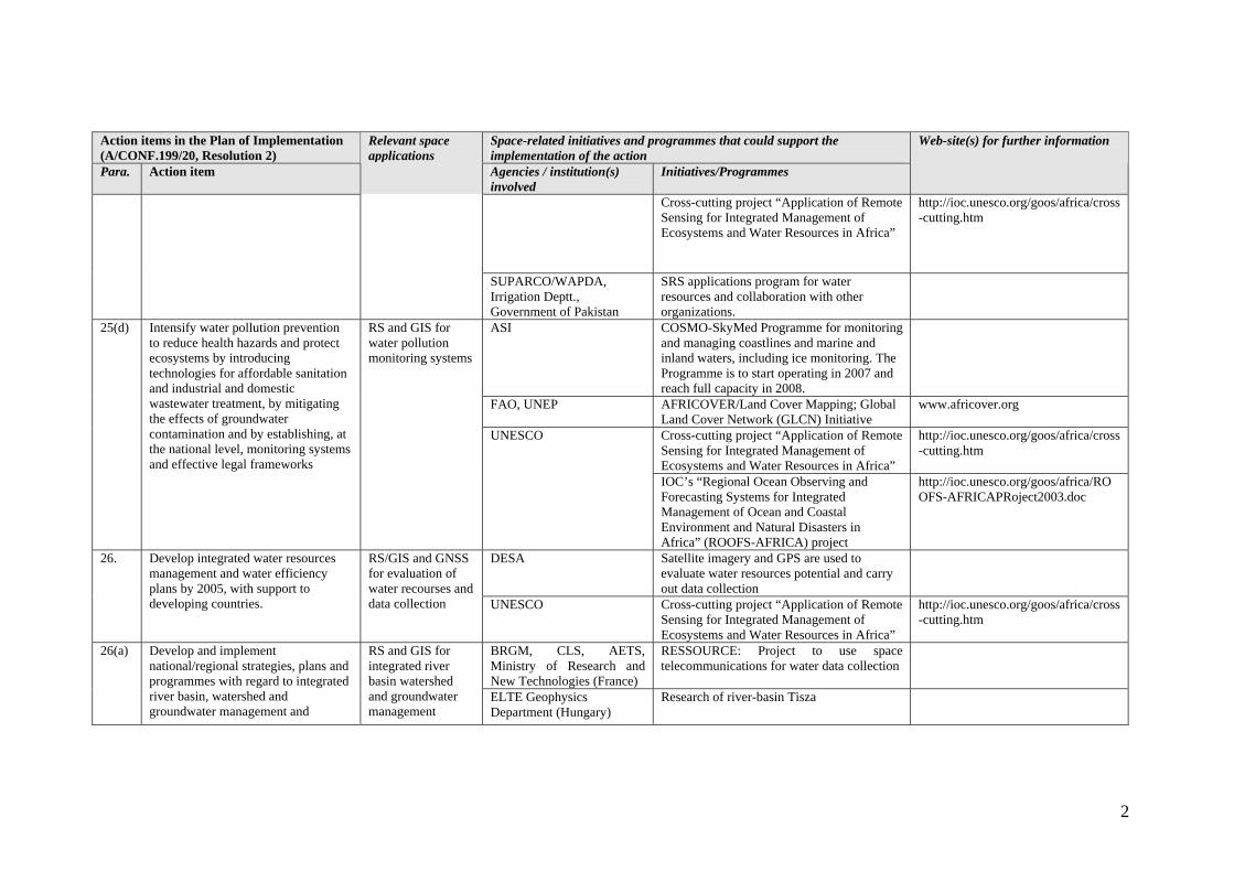
25(d) Intensify water pollution prevention to reduce health hazards and protect ecosystems by introducing technologies for affordable sanitation and industrial and domestic wastewater treatment, by mitigating the effects of groundwater contamination and by establishing, at the national level, monitoring systems and effective legal frameworks
RS and GIS for water pollution monitoring systems
UNESCO
IOC’s “Regional Ocean Observing and Forecasting Systems for Integrated Management of Ocean and Coastal Environment and Natural Disasters in Africa” (ROOFS-AFRICA) project
http://ioc.unesco.org/goos/africa/ROOFS-AFRICAPRoject2003.doc
DESA Satellite imagery and GPS are used to evaluate water resources potential and carry out data collection
26. Develop integrated water resources management and water efficiency plans by 2005, with support to developing countries.
RS/GIS and GNSS for evaluation of water recourses and data collection UNESCO Cross-cutting project “Application of Remote
Sensing for Integrated Management of Ecosystems and Water Resources in Africa”
http://ioc.unesco.org/goos/africa/cross-cutting.htm
BRGM, CLS, AETS, Ministry of Research and New Technologies (France)
RESSOURCE: Project to use space telecommunications for water data collection
26(a)
Develop and implement national/regional strategies, plans and programmes with regard to integrated river basin, watershed and groundwater management and
RS and GIS for integrated river basin watershed and groundwater management
ELTE Geophysics Department (Hungary)
Research of river-basin Tisza

3
Action items in the Plan of Implementation (A/CONF.199/20, Resolution 2)
Space-related initiatives and programmes that could support the implementation of the action
Para. Action item
Relevant space applications
Agencies / institution(s) involved
Initiatives/Programmes
Web-site(s) for further information
ASI COSMO-SkyMed Programme for monitoring and managing coastlines and marine and inland waters, including ice monitoring. The Programme is to start operating in 2007 and reach full capacity in 2008.
FAO, UNEP AFRICOVER/Land Cover Mapping; Global Land Cover Network (GLCN) Initiative
www.africover.org
Space Hydrology International Partnership (SHIP) in cooperation with European Space Agency’s TIGER project
http://www.unesco.org/water UNESCO
Cross-cutting project “Application of Remote Sensing for Integrated Management of Ecosystems and Water Resources in Africa”
http://ioc.unesco.org/goos/africa/cross-cutting.htm
introduce measures to improve the efficiency of water infrastructure to reduce losses and increase recycling of water
SUPARCO/WAPDA Snow Cover Estimation and runoff Assessment in INDUS river Basin Using SRS/GIS data.
BRGM, CLS, AETS, Ministry of Research and New Technologies (France)
RESSOURCE: Project to use space telecommunications for water data collection
ASI COSMO-SkyMed Programme for monitoring and managing coastlines and marine and inland waters, including ice monitoring. The Programme is to start operating in 2007 and reach full capacity in 2008.
FAO, UNEP AFRICOVER/Land Cover Mapping; Global Land Cover Network (GLCN) Initiative
www.africover.org
Space Hydrology International Partnership (SHIP) in cooperation with European Space Agency’s TIGER project
http://www.unesco.org/water
26(b) Employ the full range of policy instruments, including regulation, monitoring, voluntary measures, market and information-based tools, land-use management and cost recovery of water services, without cost recovery objectives becoming a barrier to access to safe water by poor people, and adopt an integrated water basin approach
RS and GIS for monitoring and information gathering for decision-making
UNESCO
Cross-cutting project “Application of Remote Sensing for Integrated Management of Ecosystems and Water Resources in Africa”
http://ioc.unesco.org/goos/africa/cross-cutting.htm

4
Action items in the Plan of Implementation (A/CONF.199/20, Resolution 2)
Space-related initiatives and programmes that could support the implementation of the action
Para. Action item
Relevant space applications
Agencies / institution(s) involved
Initiatives/Programmes
Web-site(s) for further information
EADS, Astrium, Alcatel Space, MétéoFrance, Cemagref, BRGM, SPOT Image, SCOT, MSI, Sertit Irit, IMFT, Ministry of Research and New Technologies (France)
PACTES project: flood prediction and prevention using space technology
ASI COSMO-SkyMed Programme for monitoring and managing coastlines and marine and inland waters, including ice monitoring. The Programme is to start operating in 2007 and reach full capacity in 2008.
Global Information and Early Warning System (GIEWS), which uses the Advanced Real Time Environmental Monitoring Information System (ARTEMIS)
http://www.fao.org/giews/english/index.htm, http://geoweb.fao.org
FAO
Southern African Development Community (SADC) Regional Remote Sensing Unit with the use of ARTEMIS
http://metart.fao.org, www.sadc.int
FAO, UNEP AFRICOVER/Land Cover Mapping; Global Land Cover Network (GLCN) Initiative
www.africover.org
ESCAP Regional Space Applications Programme for Sustainable Development in Asia and the Pacific (RESAP)
http://www.unescap.org/icstd/ SPACE/resap/resap_main.asp
Hydrology and Water Resources Programme http://www.wmo.ch/web/wcp/wcp-home.html
WMO
Natural Disaster Prebention and Mitigation Programme
OOSA, UNOPS Serving the UN with satellite imagery and value adding products through International Charter “Space and Major Disasters”
www.unosat.org, www.disasterscharter.org
26(d) Develop programmes for mitigating the effects of extreme water-related events
RS and GIS for preventing and mitigating effects of extreme water-related events
UNOPS Global Mapping Grant Facility www.unosat.org
5
Action items in the Plan of Implementation (A/CONF.199/20, Resolution 2)
Space-related initiatives and programmes that could support the implementation of the action
Para. Action item
Relevant space applications
Agencies / institution(s) involved
Initiatives/Programmes
Web-site(s) for further information
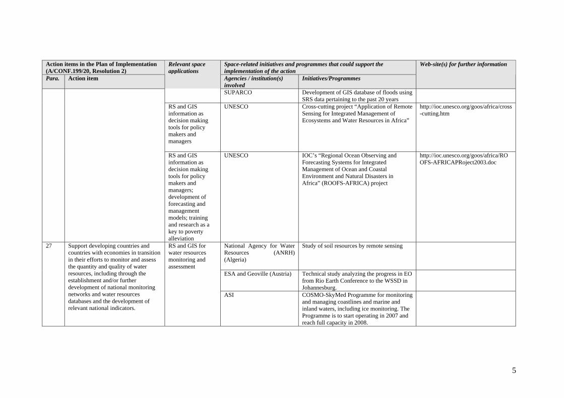
SUPARCO Development of GIS database of floods using SRS data pertaining to the past 20 years
RS and GIS information as decision making tools for policy makers and managers
UNESCO Cross-cutting project “Application of Remote Sensing for Integrated Management of Ecosystems and Water Resources in Africa”
http://ioc.unesco.org/goos/africa/cross-cutting.htm
RS and GIS information as decision making tools for policy makers and managers; development of forecasting and management models; training and research as a key to poverty alleviation
UNESCO IOC’s “Regional Ocean Observing and Forecasting Systems for Integrated Management of Ocean and Coastal Environment and Natural Disasters in Africa” (ROOFS-AFRICA) project
http://ioc.unesco.org/goos/africa/ROOFS-AFRICAPRoject2003.doc
National Agency for Water Resources (ANRH) (Algeria)
Study of soil resources by remote sensing
ESA and Geoville (Austria) Technical study analyzing the progress in EO from Rio Earth Conference to the WSSD in Johannesburg.
27 Support developing countries and countries with economies in transition in their efforts to monitor and assess the quantity and quality of water resources, including through the establishment and/or further development of national monitoring networks and water resources databases and the development of relevant national indicators.
RS and GIS for water resources monitoring and assessment
ASI COSMO-SkyMed Programme for monitoring and managing coastlines and marine and inland waters, including ice monitoring. The Programme is to start operating in 2007 and reach full capacity in 2008.

6
Action items in the Plan of Implementation (A/CONF.199/20, Resolution 2)
Space-related initiatives and programmes that could support the implementation of the action
Para. Action item
Relevant space applications
Agencies / institution(s) involved
Initiatives/Programmes
Web-site(s) for further information
Global Information and Early Warning System (GIEWS), which uses the Advanced Real Time Environmental Monitoring Information System (ARTEMIS)
http://www.fao.org/giews/english/index.htm, http://geoweb.fao.org
FAO
Southern African Development Community (SADC) Regional Remote Sensing Unit with the use of ARTEMIS
http://metart.fao.org, http://www.sadc.int/
FAO, UNEP AFRICOVER/Land Cover Mapping; Global Land Cover Network (GLCN) Initiative
www.africover.org
WMO Hydrology and Water Resources Programme http://www.wmo.ch/web/wcp/wcp-home.html
Space Hydrology International Partnership (SHIP) in cooperation with European Space Agency’s TIGER project
http://www.unesco.org/water
Cross-cutting project “Application of Remote Sensing for Integrated Management of Ecosystems and Water Resources in Africa”
http://ioc.unesco.org/goos/africa/cross-cutting.htm
UNESCO
IOC’s “Regional Ocean Observing and Forecasting Systems for Integrated Management of Ocean and Coastal Environment and Natural Disasters in Africa” (ROOFS-AFRICA) project
http://ioc.unesco.org/goos/africa/ROOFS-AFRICAPRoject2003.doc
Australia’s Department of the Environment and Heritage (DEH)
Various initiatives that use Earth observing remote sensing and GIS data analysis
http://www.deh.gov.au/
CNES - ISRO Mégha-Tropique project for water studies
28. Improve water resource management and scientific understanding of the water cycle through cooperation in joint observation and research, and for this purpose encourage and promote knowledge-sharing and provide capacity-building and the transfer of technology, as mutually agreed,
RS and GIS for water resource management and scientific understanding of the water cycle
CNES – ESA – CDPI (France)
Surface Meteorological Observation System (SMOS) for global observation of land surface humidity and ocean salinity. Climate forecasting

7
Action items in the Plan of Implementation (A/CONF.199/20, Resolution 2)
Space-related initiatives and programmes that could support the implementation of the action
Para. Action item
Relevant space applications
Agencies / institution(s) involved
Initiatives/Programmes
Web-site(s) for further information
ASI COSMO-SkyMed Programme for monitoring and managing coastlines and marine and inland waters, including ice monitoring. The Programme is to start operating in 2007 and reach full capacity in 2008.
Global Information and Early Warning System (GIEWS), which uses the Advanced Real Time Environmental Monitoring Information System (ARTEMIS)
http://www.fao.org/giews/english/index.htm, http://geoweb.fao.org
FAO
Southern African Development Community (SADC) Regional Remote Sensing Unit with the use of ARTEMIS
http://metart.fao.org, http://www.sadc.int/
FAO, UNEP AFRICOVER/Land Cover Mapping; Global Land Cover Network (GLCN) Initiative
www.africover.org
ESCAP Regional Space Applications Programme for Sustainable Development in Asia and the Pacific (RESAP)
http://www.unescap.org/icstd/ SPACE/resap/resap_main.asp
Hydrology and Water Resources Programme http://www.wmo.ch/web/homs/hwrpframes.html
WMO
WMO Space Programme http://www.wmo.ch/index-en.html Cross-cutting project “Application of Remote Sensing for Integrated Management of Ecosystems and Water Resources in Africa”
http://ioc.unesco.org/goos/africa/cross-cutting.htm
including remote-sensing and satellite technologies, particularly to developing countries and countries with economies in transition.
UNESCO
IOC’s “Regional Ocean Observing and Forecasting Systems for Integrated Management of Ocean and Coastal Environment and Natural Disasters in Africa” (ROOFS-AFRICA) project
http://ioc.unesco.org/goos/africa/ROOFS-AFRICA.htm
- Coastal area management - 30(b) Promote the implementation of
chapter 17 of Agenda 21, which provides the programme of action for
RS and GIS for integrated management of
Ministry for Regional Planning and the Environment (Algeria)
Mapping of development indicators by remote sensing. Blue Plan
8
Action items in the Plan of Implementation (A/CONF.199/20, Resolution 2)
Space-related initiatives and programmes that could support the implementation of the action
Para. Action item
Relevant space applications
Agencies / institution(s) involved
Initiatives/Programmes
Web-site(s) for further information
CLS, IRD, Thales, SODENA, Ministry of Research and New Technologies (France)
Integrated fish stock resource management aid service (SEAGERH)
CLS (France) Argos beacon applications ASI COSMO-SkyMed Programme for monitoring
and managing coastlines and marine and inland waters, including ice monitoring. The Programme is to start operating in 2007 and reach full capacity in 2008.
SUPARCO, Forest Deptt. Govt. of Pakistan
SRS applications Program for oceanographic studies including development of coastal areas, etc.
ESCAP Regional Space Applications Programme for Sustainable Development in Asia and the Pacific (RESAP)
http://www.unescap.org/icstd/ SPACE/resap/resap_main.asp
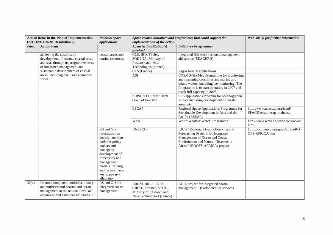
coastal areas and marine resources
WMO World Weather Watch Programme http://www.wmo.ch/web/www/www.html
achieving the sustainable development of oceans, coastal areas and seas through its programme areas of integrated management and sustainable development of coastal areas, including exclusive economic zones
RS and GIS information as decision making tools for policy makers and managers; development of forecasting and management models; training and research as a key to poverty alleviation
UNESCO IOC’s “Regional Ocean Observing and Forecasting Systems for Integrated Management of Ocean and Coastal Environment and Natural Disasters in Africa” (ROOFS-AFRICA) project
http://ioc.unesco.org/goos/africa/ROOFS-AFRICA.htm
30(e) Promote integrated, multidisciplinary and multisectoral coastal and ocean management at the national level and encourage and assist coastal States in
RS and GIS for integrated coastal management
BRGM, BRLI, CNES, CIRAD, Ifremer, SCOT, Ministry of Research and New Technologies (France)
AGIL project for integrated coastal management. Development of services

9
Action items in the Plan of Implementation (A/CONF.199/20, Resolution 2)
Space-related initiatives and programmes that could support the implementation of the action
Para. Action item
Relevant space applications
Agencies / institution(s) involved
Initiatives/Programmes
Web-site(s) for further information
ASI COSMO-SkyMed Programme for monitoring and managing coastlines and marine and inland waters, including ice monitoring. The Programme is to start operating in 2007 and reach full capacity in 2008.
SUPARCO, NGOs, Forest Deptt. Govt. of Pakistan.
Use of SRS data and GIS for monitoring and managing coastal resources
ESCAP Regional Space Application Programme for Sustainable Development in Asia and the Pacific (RESAP)
http://www.unescap.org/icstd/ SPACE/resap/resap_main.asp
developing ocean policies and mechanisms on integrated coastal management
RS and GIS information as decision making tools for policy makers and managers; development of forecasting and management models; training and research as a key to poverty alleviation
UNESCO IOC’s “Regional Ocean Observing and Forecasting Systems for Integrated Management of Ocean and Coastal Environment and Natural Disasters in Africa” (ROOFS-AFRICA) project
http://ioc.unesco.org/goos/africa/ROOFS-AFRICA.htm
SPOT Image, IRD, Ifremer, Ministry of Research and New Technologies (France)
IBIS for tracking of vessels
ESA/EU Galileo and satellite navigation applications
31(d) Urgently develop and implement national and, where appropriate, regional plans of action, to put into effect the international plans of action of the Food and Agriculture
RS and GIS information as decision making tools for policy makers and CLS Data collection with Argos beacons

10
Action items in the Plan of Implementation (A/CONF.199/20, Resolution 2)
Space-related initiatives and programmes that could support the implementation of the action
Para. Action item
Relevant space applications
Agencies / institution(s) involved
Initiatives/Programmes
Web-site(s) for further information
ASI COSMO-SkyMed Programme for monitoring and managing coastlines and marine and inland waters, including ice monitoring. The Programme is to start operating in 2007 and reach full capacity in 2008.
Organization of the United Nations, in particular the International Plan of Action for the Management of Fishing Capacity1 by 2005 and the International Plan of Action to Prevent, Deter and Eliminate Illegal, Unreported and Unregulated Fishing by 2004. Establish effective monitoring, reporting and enforcement, and control of fishing vessels, including by flag States, to further the International Plan of Action to Prevent, Deter and Eliminate Illegal, Unreported and Unregulated Fishing
managers; development of forecasting and management models; training and research as a key to poverty alleviation
UNESCO IOC’s “Regional Ocean Observing and Forecasting Systems for Integrated Management of Ocean and Coastal Environment and Natural Disasters in Africa” (ROOFS-AFRICA) project
http://ioc.unesco.org/goos/africa/ROOFS-AFRICA.htm
35 Governments, taking into account their national circumstances, are encouraged, recalling paragraph 8 of resolution GC (44)/RES/17 of the General Conference of the International Atomic Energy Agency, and taking into account the very
Work of the Scientific and Technical Subcommittee of COPUOS in the use of nuclear sources in outer space
ASI COSMO-SkyMed Programme for monitoring and managing coastlines and marine and inland waters, including ice monitoring. The programme can also be used for intelligence applications for strategic purposes.The Programme is to start operating in 2007 and reach full capacity in 2008.
1 Rome, Food and Agriculture Organization of the United Nations, 1999.

11
Action items in the Plan of Implementation (A/CONF.199/20, Resolution 2)
Space-related initiatives and programmes that could support the implementation of the action
Para. Action item
Relevant space applications
Agencies / institution(s) involved
Initiatives/Programmes
Web-site(s) for further information
serious potential for environment and human health impacts of radioactive wastes, to make efforts to examine and further improve measures and internationally agreed regulations regarding safety, while stressing the importance of having effective liability mechanisms in place, relevant to international maritime transportation and other transboundary movement of radioactive material, radioactive waste and spent fuel, including, inter alia, arrangements for prior notification and consultations done in accordance with relevant international instruments
ESA and Geoville (Austria) Technical study analyzing the progress in EO from Rio Earth Conference to the WSSD in Johannesburg.
ESA and Geoville (Austria) Project in support for the Water Framework Directive and the Soil Protection Initiative
36. World Summit on Sustainable Development – Plan of Implementation – specific references to Earth Observation
Study on Earth Observation Applications for Sustainable Development
ASI COSMO-SkyMed Programme for scientific applications. The Programme is to start operating in 2007 and reach full capacity in 2008.
TOPEX-Poseidon for altimetric measurements (ocean circulation, etc.)
CNES - NASA
Jason-1 for global altimetric measurements of the oceans, following TOPEX-Poseidon. General meteorology and climate understanding.
36(a) Increase scientific and technical collaboration, including integrated assessment at the global and regional levels, including the appropriate transfer of marine science and marine technologies and techniques for the conservation and management of living and non-living marine resources and expanding ocean-
RS to monitor ocean
CNES – MétéoFrance - IRD - SHOM
MERCATOR for ocean simulation on the basis of satellite observation; climate forecasting

12
Action items in the Plan of Implementation (A/CONF.199/20, Resolution 2)
Space-related initiatives and programmes that could support the implementation of the action
Para. Action item
Relevant space applications
Agencies / institution(s) involved
Initiatives/Programmes
Web-site(s) for further information
CNES-ESA-CDPI (France) Surface Meteorological Observation System (SMOS) for global observation of land surface humidity and ocean salinity; climate forecasting
CNES – CNRS – IRD – IPEV – Ifremer –MétéoFrance - SHOM
France’s participation in the Global Ocean Observing System (GOOS) using CORIOLIS and MERCATOR
ASI COSMO-SkyMed Programme for monitoring and managing coastlines and marine and inland waters, including ice monitoring. The Programme can also be used for ecological monitoring. The Programme is to start operating in 2007 and reach full capacity in 2008.
ESCAP Regional Space Application Programme for Sustainable Development in Asia and the Pacific (RESAP)
http://www.unescap.org/icstd/ SPACE/resap/resap_main.asp
WMO Applications of Meteorology Programme http://www.wmo.ch/web/aom/aom.html
UNESCO IOC’s Global Ocean Observing System (GOOS) Regional Alliances
http://ioc.unesco.org/iocweb/index.php
observing capabilities for the timely prediction and assessment of the state of marine environment
UNESCO, WMO, UNEP Intergovernmental Oceanographic Commission’s (IOC) Global Ocean Observing System (GOOS) Regional Alliances including those for Africa, Black Sea, Mediterranean, Caribbean, Indian Ocean, Pacific Islands, North-East and South-East Asia, South-East Pacific
Thales, SODENA, IRD, CLS, Ministry of Research and New Technologies (France)
SEAGERH project 36(c) Build capacity in marine science, information and management, through, inter alia, promoting the use of environmental impact assessments and environmental evaluation and
RS for marine management
CLS Data collection using Argos beacons

13
Action items in the Plan of Implementation (A/CONF.199/20, Resolution 2)
Space-related initiatives and programmes that could support the implementation of the action
Para. Action item
Relevant space applications
Agencies / institution(s) involved
Initiatives/Programmes
Web-site(s) for further information
BRGM – BRLI – CNES – CIRAD – Ifremer - SCOT (France)
AGIL project for integrated coastal management
ASI COSMO-SkyMed Programme for monitoring and managing coastlines and marine and inland waters, including ice monitoring. The Programme can also be used for scientific applications. The Programme is to start operating in 2007 and reach full capacity in 2008.
ESCAP Regional Space Applications Programme for Sustainable Development (RESAP)
http://www.unescap.org/icstd/ SPACE/resap/resap_main.asp
Intergovernmental Oceanographic Commission’s (IOC) Ocean Data and Information (ODIN) for Africa, the Caribbean and South America
http://ioc.unesco.org/iocweb/index.php
reporting techniques, for projects or activities that are potentially harmful to the coastal and marine environments and their living and non-living resources
UNESCO
IOC’s “Regional Ocean Observing and Forecasting Systems for Integrated Management of Ocean and Coastal Environment and Natural Disasters in Africa” (ROOFS-AFRICA) project
http://ioc.unesco.org/goos/africa/ROOFS-AFRICA.htm
CNES-CNRS-IRD-IPEV-Ifremer-MétéoFrance-SHOM
France’s participation in the GOOS project with CORIOLIS and MERCATOR
WMO Applications of Meteorology Programme http://www.wmo.ch/web/aom/aom.html
36(d) Strengthen the ability of the Intergovernmental Oceanographic Commission of the United Nations Educational, Scientific and Cultural Organization, the Food and Agriculture Organization of the United Nations and other relevant international and regional and subregional organizations to build national and local capacity in marine science and the sustainable management of oceans and their
RS for marine science and sustainable management of oceans and their resources
UNESCO All Intergovernmental Oceanographic Commission’s (IOC) programmes, including the Integrated Coastal Area Management (ICAM), Global Observing System (GOS) and International Oceanographic Data and Information Exchange (IODE) programmes, with the use RS data
http://ioc.unesco.org/iocweb/index.php

14
Action items in the Plan of Implementation (A/CONF.199/20, Resolution 2)
Space-related initiatives and programmes that could support the implementation of the action
Para. Action item
Relevant space applications
Agencies / institution(s) involved
Initiatives/Programmes
Web-site(s) for further information
resources SUPARCO, NGOs
Monitoring Coastal ecosystem and marine envt. through SRS technology.
- Disaster management - BMVIT – Austrian Federal Ministry for Transport, Innovation and Technology
Disaster Management – Elaboration of an Austrian Action plan for the implementation of the International Charter for Space and Natural Disasters
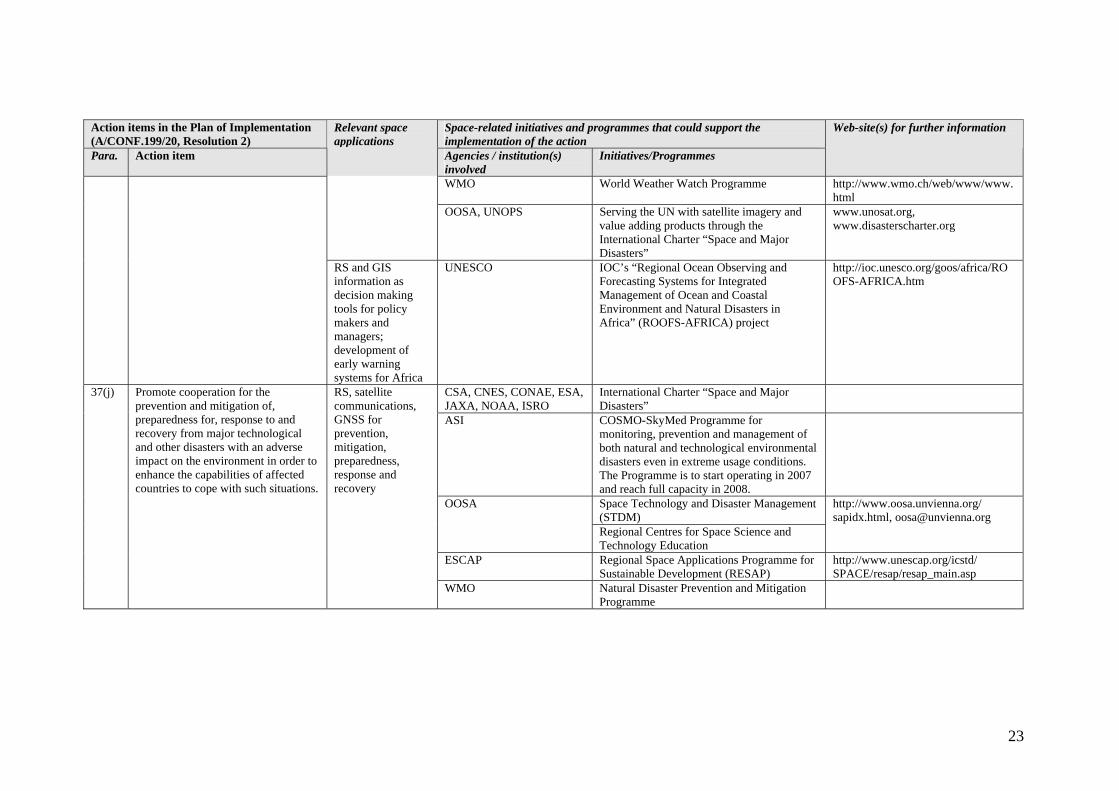
CSA, CNES, CONAE, ESA, JAXA, NOAA, ISRO
International Charter “Space and Major Disasters”
EADS Astrium, CS-SI, CEREN, CNES, FDC, MétéoFrance, PONT Intervention, SCOT, French Ministry of Research and New Technologies (France)
PARAFEU to combat forest fires
EADS Astrium, Alcatel Space, MétéoFrance, Cemagref, BRGM, SPOT Image, SCOT, MSI, Sertit Irit, IMFT, Ministry of Research and New Technologies (France)
PACTES: flood prediction and prevention using space technology
37(b) Support the establishment of effective regional, subregional and national strategies and scientific and technical institutional support for disaster management
RS and GIS, satellite communications, GNSS for disaster management
ASI COSMO-SkyMed Programme for monitoring, prevention and management of both natural and technological environmental disasters even in extreme usage conditions. The Programme is to start operating in 2007 and reach full capacity in 2008.
15
Action items in the Plan of Implementation (A/CONF.199/20, Resolution 2)
Space-related initiatives and programmes that could support the implementation of the action
Para. Action item
Relevant space applications
Agencies / institution(s) involved
Initiatives/Programmes
Web-site(s) for further information
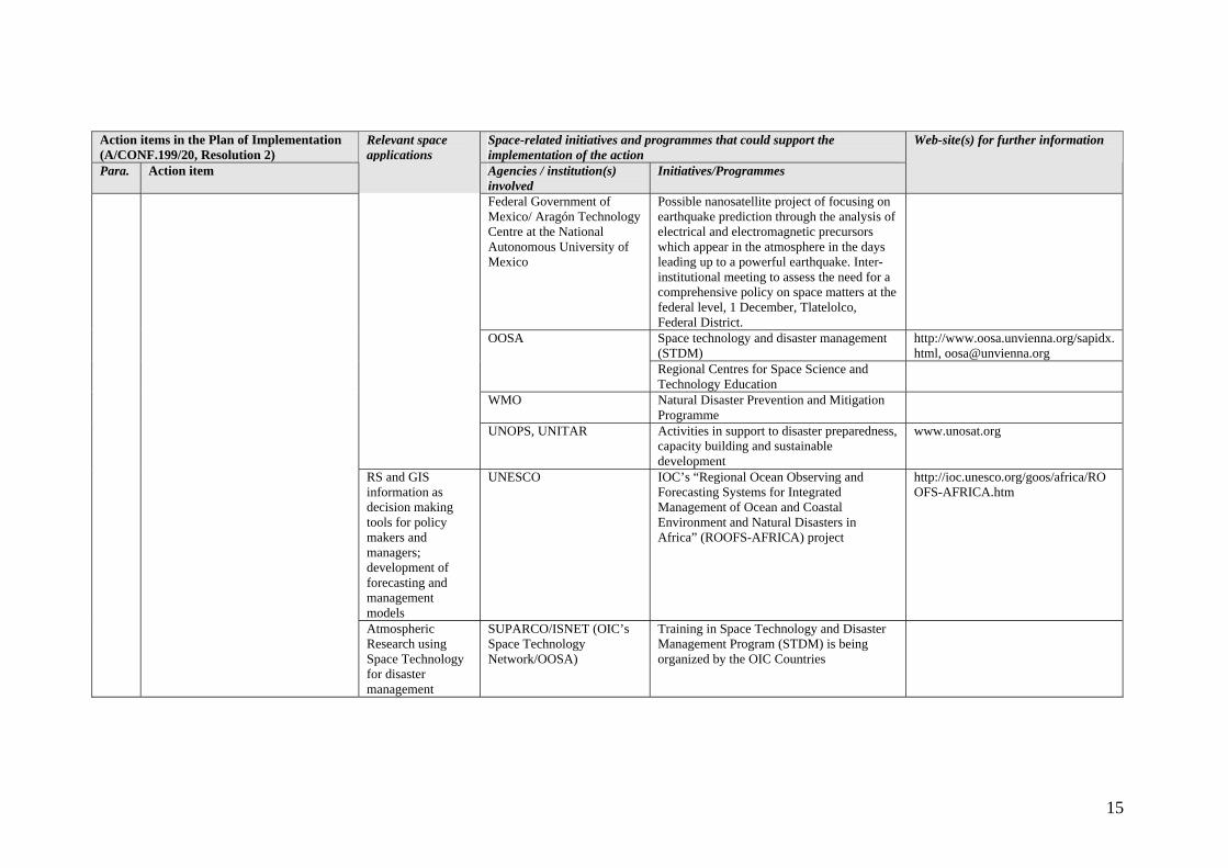
Federal Government of Mexico/ Aragón Technology Centre at the National Autonomous University of Mexico
Possible nanosatellite project of focusing on earthquake prediction through the analysis of electrical and electromagnetic precursors which appear in the atmosphere in the days leading up to a powerful earthquake. Inter-institutional meeting to assess the need for a comprehensive policy on space matters at the federal level, 1 December, Tlatelolco, Federal District.
Space technology and disaster management (STDM)
http://www.oosa.unvienna.org/sapidx.html, [email protected]
OOSA
Regional Centres for Space Science and Technology Education
WMO Natural Disaster Prevention and Mitigation Programme
UNOPS, UNITAR Activities in support to disaster preparedness, capacity building and sustainable development
www.unosat.org
RS and GIS information as decision making tools for policy makers and managers; development of forecasting and management models
UNESCO IOC’s “Regional Ocean Observing and Forecasting Systems for Integrated Management of Ocean and Coastal Environment and Natural Disasters in Africa” (ROOFS-AFRICA) project
http://ioc.unesco.org/goos/africa/ROOFS-AFRICA.htm
Atmospheric Research using Space Technology for disaster management
SUPARCO/ISNET (OIC’s Space Technology Network/OOSA)
Training in Space Technology and Disaster Management Program (STDM) is being organized by the OIC Countries

16
Action items in the Plan of Implementation (A/CONF.199/20, Resolution 2)
Space-related initiatives and programmes that could support the implementation of the action
Para. Action item
Relevant space applications
Agencies / institution(s) involved
Initiatives/Programmes
Web-site(s) for further information
CNES – ESA – NASA – LPCE – CETP – MPG
DEMETER (Detection of Electro-Magnetic Emissions Transmitted from Earthquake Regions)
CNES-CNRS, supported by IRMB and WRC
PICARD for determining solar forcing influence on Earth climate
ELTE Geophysics Department (Hungary)
Satellite data processing
ASI COSMO-SkyMed Programme for scientific applications. The Programme is to start operating in 2007 and reach full capacity in 2008.
Federal Government of Mexico/ Aragón Technology Centre at the National Autonomous University of Mexico
Possible nanosatellite project of focusing on earthquake prediction through the analysis of electrical and electromagnetic precursors which appear in the atmosphere in the days leading up to a powerful earthquake. Inter-institutional meeting to assess the need for a comprehensive policy on space matters at the federal level, 1 December, Tlatelolco, Federal District.
Space Technology and Disaster Management (STDM)
OOSA
Regional Centres for Space Science and Technology Education
http://www.oosa.unvienna.org/sapidx.html [email protected]
ESCAP Regional Space Applications Programme for Sustainable Development in Asia and the Pacific (RESAP)
World Weather Watch Programme http://www.wmo.ch/web/www/www.html
WMO
WMO Space Programme http://www.wmo.ch/ hinsman/satsun.html
37(c) Strengthen the institutional capacities of countries and promote international joint observation and research, through improved surface-based monitoring and increased use of satellite data, dissemination of technical and scientific knowledge, and the provision of assistance to vulnerable countries
RS and GIS for joint observation and research
UNOPS, UNITAR Activities in support to disaster preparedness, capacity building and sustainable development
www.unosat.org

17
Action items in the Plan of Implementation (A/CONF.199/20, Resolution 2)
Space-related initiatives and programmes that could support the implementation of the action
Para. Action item
Relevant space applications
Agencies / institution(s) involved
Initiatives/Programmes
Web-site(s) for further information
RS and GIS information as decision making tools for policy makers and managers; development of forecasting and management models; training and research as a key to poverty alleviation
UNESCO IOC’s “Regional Ocean Observing and Forecasting Systems for Integrated Management of Ocean and Coastal Environment and Natural Disasters in Africa” (ROOFS-AFRICA) project
http://ioc.unesco.org/goos/africa/ROOFS-AFRICA.htm
RS and GIS information as decision making tools for policy makers and managers; development of forecasting and management models
UNESCO Cross-cutting project “Application of Remote Sensing for Integrated Management of Ecosystems and Water Resources in Africa”
http://ioc.unesco.org/goos/africa/cross-cutting.htm
Atmospheric Research using Space Technology for Post Disaster Management
SUPARCO/ISNET (OIC’s Space Technology Network/OOSA)
Institutional capabilities of Islamic countries is being strengthened using Space Technology and Disaster Management Program (STDM)

18
Action items in the Plan of Implementation (A/CONF.199/20, Resolution 2)
Space-related initiatives and programmes that could support the implementation of the action
Para. Action item
Relevant space applications
Agencies / institution(s) involved
Initiatives/Programmes
Web-site(s) for further information
Alcatel Space Industries (ASPI), Astrium, MétéoFrance, Cemagref, BRGM, SPOT Image, SCOT, MSI, Sertit Irit, IMFT, Ministry of Research and New Technologies (France)
PACTES
ELTE Geophysics Department (Hungary)
Research of river-basin Tisza
ASI COSMO-SkyMed Programme for monitoring, prevention and management of both natural and technological environmental disasters even in extreme usage conditions. The Programme is to start operating in 2007 and reach full capacity in 2008.
Space Technology and Disaster Management (STDM)
OOSA
Regional Centres for Space Science and Technology Education
http://www.oosa.unvienna.org/sapidx.html [email protected]
ESCAP Regional Space Applications Programme for Sustainable Development (RESAP)
http://www.unescap.org/icstd/ SPACE/resap/resap_main.asp
Hydrology and Water Resources Programme http://www.wmo.ch/web/homs/ 1stpage.html
WMO
Natural Disaster Prevention and Mitigation Programme
37(d) Reduce the risks of flooding and drought in vulnerable countries by, inter alia, promoting wetland and watershed protection and restoration, improved land-use planning, improving and applying more widely techniques and methodologies for assessing the potential adverse effects of climate change on wetlands and, as appropriate, assisting countries that are particularly vulnerable to those effects
RS and GIS for improved land use planning
UNOPS, UNITAR Activities in support to disaster preparedness, capacity building and sustainable development
www.unosat.org

19
Action items in the Plan of Implementation (A/CONF.199/20, Resolution 2)
Space-related initiatives and programmes that could support the implementation of the action
Para. Action item
Relevant space applications
Agencies / institution(s) involved
Initiatives/Programmes
Web-site(s) for further information
RS and GIS information as decision making tools for policy makers and managers; development of forecasting and management models
UNESCO IOC’s “Regional Ocean Observing and Forecasting Systems for Integrated Management of Ocean and Coastal Environment and Natural Disasters in Africa” (ROOFS-AFRICA) project
http://ioc.unesco.org/goos/africa/ROOFS-AFRICA.htm
Atmospheric Research using Space Technology for disaster management
Pakistan Meteorological Deptt., WAPDA
Under Space Technology and Disaster Management Program (STDM), Early Warning of these phenomena are conducted.
TOPEX-Poseidon and the DORIS instrument for altimetric measurements (ocean circulation, etc.)
CNES - NASA
Jason-1 and the DORIS instrument for global altimetric measurements of the oceans, following TOPEX-Poseidon. General meteorology and climate understanding
CNES – MétéoFrance - IRD -SHOM
MERCATOR for ocean simulation on the basis of satellite observation for climate forecasting
CNES - CNRS, supported by IRMB and WRC
PICARD to determine solar forcing influence on Earth climate
37(e) Improve techniques and methodologies for assessing the effects of climate change, and encourage the continuing assessment of those adverse effects by the Intergovernmental Panel on Climate Change
RS for assessment of the effects of climate change
CNES PARASOL to determine influence of radiative impact of clouds and aerosols on climate change

20
Action items in the Plan of Implementation (A/CONF.199/20, Resolution 2)
Space-related initiatives and programmes that could support the implementation of the action
Para. Action item
Relevant space applications
Agencies / institution(s) involved
Initiatives/Programmes
Web-site(s) for further information
CNES - NASA Cloud-Aerosol Lidar and Infrared Pathfinder Satellite (CALIPSO) study on radiative impact of clouds and aerosols on understanding of climate systems and global change
CNES – ESA – CDPI SMOS for global observation of land surface humidity and ocean salinity; climate forecasting
CNES - CLS SALP production, archiving and distribution of TOPEX-Poseidon, Jason, DORIS and ENVISAT mission products
CNES, the Belgian, Swedish and Italian space stations and the European Commission
VEGETATION instrument for crop and continental biosphere observation
CNES for DORIS and ESA for the ENVISAT satellite
DORIS instrument on ENVISAT
ASI COSMO-SkyMed Programme for monitoring, prevention and management of both natural and technological environmental disasters even in extreme usage conditions. The programme can also perform monitoring of ice and ecology. The Programme is to start operating in 2007 and reach full capacity in 2008.
Space Technology and Disaster Management (STDM)
OOSA
Regional Centres for Space Science and Technology Education
http://www.oosa.unvienna.org/sapidx.html [email protected]
WMO World Climate Programme http://www.wmo.ch/web/wcp/ wcp_prog.htm

21
Action items in the Plan of Implementation (A/CONF.199/20, Resolution 2)
Space-related initiatives and programmes that could support the implementation of the action
Para. Action item
Relevant space applications
Agencies / institution(s) involved
Initiatives/Programmes
Web-site(s) for further information
RS and GIS information as decision making tools for policy makers and managers; development of forecasting and management models
UNESCO IOC’s “Regional Ocean Observing and Forecasting Systems for Integrated Management of Ocean and Coastal Environment and Natural Disasters in Africa” (ROOFS-AFRICA) project
http://ioc.unesco.org/goos/africa/ROOFS-AFRICA.htm
Atmospheric Research for assessment of the effects of climate change
SUPARCO, Pakistan Meteorological Deptt.
Global Monitoring of various Atmospheric parameters are regularly monitored under Space Technology and Disaster Management Programme (STDM)
CSA, CNES, CONAE, ESA, JAXA, NOAA, ISRO
International Charter “Space and Major Disasters”
Hungarian Meteorological Service
Flood forecasting and management
ASI COSMO-SkyMed Programme for monitoring, prevention and management of both natural and technological environmental disasters even in extreme usage conditions. The Programme is to start operating in 2007 and reach full capacity in 2008.
Global Information and Early Warning System (GIEWS), which uses the Advanced Real Time Environmental Monitoring Information System (ARTEMIS)
http://www.fao.org/giews/english/index.htm, http://geoweb.fao.org
FAO
Southern African Development Community (SADC) Regional Remote Sensing Unit with the use of ARTEMIS
http://metart.fao.org, www.sadc.int
37(h) Develop and strengthen early warning systems and information networks in disaster management, consistent with the International Strategy for Disaster Reduction
RS and satellite communications for early warning
OOSA Space Technology and Disaster Management (STDM)
http://www.oosa.unvienna.org/sapidx.html

22
Action items in the Plan of Implementation (A/CONF.199/20, Resolution 2)
Space-related initiatives and programmes that could support the implementation of the action
Para. Action item
Relevant space applications
Agencies / institution(s) involved
Initiatives/Programmes
Web-site(s) for further information
Regional Centres for Space Science and Technology Education
ESCAP Regional Space Applications Programme for Sustainable Development (RESAP)
http://www.unescap.org/icstd/ SPACE/resap/resap_main.asp
WMO Natural Disaster Prevention and Mitigation Programme
RS and GIS information as decision making tools for policy makers and managers; development of forecasting and management models
UNESCO IOC’s “Regional Ocean Observing and Forecasting Systems for Integrated Management of Ocean and Coastal Environment and Natural Disasters in Africa” (ROOFS-AFRICA) project
http://ioc.unesco.org/goos/africa/ROOFS-AFRICA.htm
Atmospheric Research/Monitoring for Early Warning.
SUPARCO/OOSA/WMO Early Warning on a predicted disaster is publicized through SUPARCO’s Web Site, and Media.
CSA, CNES, CONAE, ESA, JAXA, NOAA, ISRO
International Charter “Space and Major Disasters”
ASI COSMO-SkyMed Programme for monitoring, prevention and management of both natural and technological environmental disasters even in extreme usage conditions. The Programme is to start operating in 2007 and reach full capacity in 2008.
Space Technology and Disaster Management (STDM)
OOSA
Regional Centres for Space Science and Technology Education
http://www.oosa.unvienna.org/ sapidx.html [email protected]
37(i) Develop and strengthen capacity at all levels to collect and disseminate scientific and technical information, including the improvement of early warning systems for predicting extreme weather events, especially El Niño/La Niña, through the provision of assistance to institutions devoted to addressing such events, including the International Centre for the Study of the El Niño phenomenon
RS, GNSS and satellite communications for early warning
ESCAP Regional Space Applications Programme for Sustainable Development (RESAP)
http://www.unescap.org/icstd/ SPACE/resap/resap_main.asp
23
Action items in the Plan of Implementation (A/CONF.199/20, Resolution 2)
Space-related initiatives and programmes that could support the implementation of the action
Para. Action item
Relevant space applications
Agencies / institution(s) involved
Initiatives/Programmes
Web-site(s) for further information
WMO World Weather Watch Programme http://www.wmo.ch/web/www/www.html
OOSA, UNOPS Serving the UN with satellite imagery and value adding products through the International Charter “Space and Major Disasters”
www.unosat.org, www.disasterscharter.org
RS and GIS information as decision making tools for policy makers and managers; development of early warning systems for Africa
UNESCO IOC’s “Regional Ocean Observing and Forecasting Systems for Integrated Management of Ocean and Coastal Environment and Natural Disasters in Africa” (ROOFS-AFRICA) project
http://ioc.unesco.org/goos/africa/ROOFS-AFRICA.htm
CSA, CNES, CONAE, ESA, JAXA, NOAA, ISRO
International Charter “Space and Major Disasters”
ASI COSMO-SkyMed Programme for monitoring, prevention and management of both natural and technological environmental disasters even in extreme usage conditions. The Programme is to start operating in 2007 and reach full capacity in 2008.
Space Technology and Disaster Management (STDM)
OOSA
Regional Centres for Space Science and Technology Education
http://www.oosa.unvienna.org/ sapidx.html, [email protected]
ESCAP Regional Space Applications Programme for Sustainable Development (RESAP)
http://www.unescap.org/icstd/ SPACE/resap/resap_main.asp
37(j) Promote cooperation for the prevention and mitigation of, preparedness for, response to and recovery from major technological and other disasters with an adverse impact on the environment in order to enhance the capabilities of affected countries to cope with such situations.
RS, satellite communications, GNSS for prevention, mitigation, preparedness, response and recovery
WMO Natural Disaster Prevention and Mitigation Programme

24
Action items in the Plan of Implementation (A/CONF.199/20, Resolution 2)
Space-related initiatives and programmes that could support the implementation of the action
Para. Action item
Relevant space applications
Agencies / institution(s) involved
Initiatives/Programmes
Web-site(s) for further information
Atmospheric Research using Space Technology for disaster management
SUPARCO/ISNET (OIC’s Space Technology Network) OOSA
The stake holders from regional countries are trained on the subject under a collaboration program
- Climate change - CNES – CNRS - INSU ETHER database on atmospheric chemistry CNES – CLS – MétéoFrance – SHOM - CERFACS
AVISO ocean, altimetry and climate database
CNES – MétéoFrance – IRD - SHOM
MERCATOR for ocean simulation on the basis of satellite observation; climate forecasting
Hungarian Meteorological Service
Research of climate change (NOAA data)
ASI COSMO-SkyMed Programme for ecological monitoring. The Programme is to start operating in 2007 and reach full capacity in 2008.
FAO, UNEP AFRICOVER/Land Cover Mapping; Global Land Cover Network (GLCN) Initiative
www.africover.org
WMO World Climate Programme http://www.wmo.ch/web/ wcp/wcp_prog.htm
Earth observation (EO) satellites and satellite communications for exchange of scientific data and information
SUPARCO, Ministry of Environment
Preparation of inventory of green house gases as per the guidelines available in IPCC. Land /atmosphere studies using MODIS / ENVISAT data.
38(d) Build and enhance scientific and technological capabilities, inter alia, through continuing support to the Intergovernmental Panel on Climate Change for the exchange of scientific data and information especially in developing countries
RS and GIS information as decision making tools for policy makers and managers; development of early warning systems for Africa
UNESCO IOC’s “Regional Ocean Observing and Forecasting Systems for Integrated Management of Ocean and Coastal Environment and Natural Disasters in Africa” (ROOFS-AFRICA) project
http://ioc.unesco.org/goos/africa/ROOFS-AFRICA.htm

25
Action items in the Plan of Implementation (A/CONF.199/20, Resolution 2)
Space-related initiatives and programmes that could support the implementation of the action
Para. Action item
Relevant space applications
Agencies / institution(s) involved
Initiatives/Programmes
Web-site(s) for further information
CNES – ESA - CDPI SMOS for global observation of surface humidity of land and salinity of oceans; climate forecasting
CNES – ESA – NASA – LPCE – CETP – MPG
DEMETER for measuring geophysical parameters of the terrestrial ionosphere affecting earthquakes or volcanic activity
CNES – NASA CALIPSO study of radiative impact of clouds and aerosols on understanding of climate systems and global change
CNES – ISRO Megha-Tropiques for study of atmospheric water cycle in the intertropical band
CNES – EUMETSAT Infrared atmospheric sounding interferometer (IASI) instrument of the METOP satellites for spectral analysis of the atmosphere and its chemical composition
ESA - Alcatel Space – Ifremer – MétéoFrance - MERCATOR-Ocean - CLS and DNV – NERSC – GTD – Starlab – NCMR – ESYS - SOS
Global Monitoring for Environment and Security (GMES) and Real Time Ocean Services for Environment and Security (ROSES) project
CNES-SPOT Image, supported by Belgium and Sweden
SPOT satellites
Alcatel Space - ESA Medium Resolution Imaging Spectrometer (MERIS) instrument on ENVISAT for study of biosphere
38(g) Promote the systematic observation of the Earth’s atmosphere, land and oceans by improving monitoring stations, increasing the use of satellites and appropriate integration of these observations to produce high-quality data that could be disseminated for the use of all countries, in particular developing countries
EO satellites for systematic observation of Earth’s atmosphere, land and oceans
CNES - NASA TOPEX-Poseidon for altimetric measurements (ocean circulation etc.)

26
Action items in the Plan of Implementation (A/CONF.199/20, Resolution 2)
Space-related initiatives and programmes that could support the implementation of the action
Para. Action item
Relevant space applications
Agencies / institution(s) involved
Initiatives/Programmes
Web-site(s) for further information
Jason-1 for global altimetric measurements of the oceans, following TOPEX-Poseidon. General meteorology and climate understanding
CNES – ASI – INTA - BNRS
Optical and radar federated Earth observation (ORFEO) system
CNES - CNRS supported by WRC and IRMB
PICARD to determine solar forcing influence on Earth climate
CNES PARASOL to determine influence of radiative impact of clouds and aerosols on climate change
Hungarian Meteorological Service
Agricultural surface physical parameters research
JAXA Advanced Land Observing Satellite (ALOS) ASI COSMO-SkyMed Programme for ecological
monitoring. The Programme is to start operating in 2007 and reach full capacity in 2008.
SUPARCO SGS and its upgrading for high-quality EO data.
ESCAP Regional Space Applications Programme for Sustainable Development in Asia and the Pacific (RESAP)
http://www.unescap.org/icstd/ SPACE/resap/resap_main.asp
FAO, UNEP AFRICOVER/Land Cover Mapping; Global Land Cover Network (GLCN) Initiative
www.africover.org
World Weather Watch Programme http://www.wmo.ch/web/ www/www.html
WMO
WMO Space Programme http://www.wmo.ch/hinsman/ satsun.html
UNESCO, WMO, UNEP IOC - the Global Ocean Observing System (GOOS)
http://ioc.unesco.org/iocweb/index.php

27
Action items in the Plan of Implementation (A/CONF.199/20, Resolution 2)
Space-related initiatives and programmes that could support the implementation of the action
Para. Action item
Relevant space applications
Agencies / institution(s) involved
Initiatives/Programmes
Web-site(s) for further information
Algerian Space Agency, SSTL
Disaster Monitoring Constellation Consortium DMC
ESA - EU GMES European concept Spot Image SPOT series satellites ASI – CNES – INTA - SNSB
ORFEO project
Hungarian Meteorological Service
Agricultural surface physical parameters research
ASI COSMO-SkyMed Programme for ecological monitoring. The Programme is to start operating in 2007 and reach full capacity in 2008.
SUPARCO SRS/GIS applications program in different discipline areas.
FAO, UNEP AFRICOVER/Land Cover Mapping; Global Land Cover Network (GLCN) Initiative
www.africover.org
World Weather Watch Programme http://www.wmo.ch/web/ www/www.html
WMO
WMO Space Programme http://www.wmo.ch/hinsman/satsun.html
UNESCO IOC’s regional programme in the Caribbean (IOCARIBE), Western Pacific (WESTPAC)
http://ioc.unesco.org/iocweb/index.php
38(h) Enhance the implementation of national, regional and international strategies to monitor the Earth’s atmosphere, land and oceans, including, as appropriate, strategies for integrated global observations, inter alia, with the cooperation of relevant international organizations, especially the specialized agencies, in cooperation with the United Nations Framework Convention on Climate Change
EO satellites for integrated global observations
UNESCO, WMO, UNEP GOOS Regional Alliances, including those for Africa, Black Sea, Mediterranean, Caribbean, Indian ocean, Pacific Islands, North-East and South-East Asia, South-East Pacific
http://ioc.unesco.org/iocweb/index.php
CNES - MétéoFrance and French laboratories
PARASOL project to measure the radiative impact of aerosols on Earth
39(a) Strengthen capacities of developing countries and countries with economies in transition to measure, reduce and assess the impacts of air pollution, including health impacts, and provide financial and technical support for these activities
RS for measurement of air pollution ACRI – ST – IPSL –
MétéoFrance – LOA - Ministry of Research and New Technologies (France)
Ultraviolet Forecasting Operational Service (UFOS) for exploitation of stratospheric ozone measurements, cloud cover and atmospheric aerosol content, by ENVISAT (MERIS and Global Ozone Monitoring by Occultation of Stars (GOMOS))

28
Action items in the Plan of Implementation (A/CONF.199/20, Resolution 2)
Space-related initiatives and programmes that could support the implementation of the action
Para. Action item
Relevant space applications
Agencies / institution(s) involved
Initiatives/Programmes
Web-site(s) for further information
ASI COSMO-SkyMed Programme for ecological monitoring. The Programme is to start operating in 2007 and reach full capacity in 2008.
SUPARCO Air pollution monitoring using ground based equipment is regularly conducted (ESA & ENVISAT Data are helpful in such monitoring).
WMO Atmospheric Research and Environment Programme
http://www.wmo.ch/web/arep/arep-home.html
French, Belgian and Swedish space agencies and laboratories
Odin atmospheric mission to investigate atmospheric chemistry
ASI COSMO-SkyMed Programme for ecological monitoring. The Programme is to start operating in 2007 and reach full capacity in 2008.
SUPARCO, Ministry of Envt.
Monitoring trend of ozone in the Asian region using TOMS / GOME data
Atmospheric Research and Environment Programme
http://www.wmo.ch/web/arep/arep-home.html
39(c) Further support the effective regime for the protection of the ozone layer established in the Vienna Convention for the Protection of the Ozone Layer and the Montreal Protocol, including its compliance mechanism
EO satellites for monitoring ozone layer and verifying compliance with the Montreal Protocol
WMO
WMO Space Programme http://www.wmo.ch/hinsman/satsun.html
- Agriculture - MétéoFrance – CETP – GEOSYS – AFEID
CITRAM irrigation advisory project. Irrigation management, soil water determination
40(b) Develop and implement integrated land management and water-use plans that are based on sustainable use of renewable resources and on integrated assessments of socio-economic and environmental potentials and
RS and GIS for management of land and water resources INRA – CNRM –
MétéoFrance – Astrium – SCOT
APOGEE project for land use planning assistance at regional level

29
Action items in the Plan of Implementation (A/CONF.199/20, Resolution 2)
Space-related initiatives and programmes that could support the implementation of the action
Para. Action item
Relevant space applications
Agencies / institution(s) involved
Initiatives/Programmes
Web-site(s) for further information
CIRAD – IGN - ministries of the environment of the relevant countries, Ministry of Research and New Technologies (France)
SHERPA hydrological and environmental monitoring project for Central America
ITCF – GEOSYS – Ministry of Research and New Technologies (France)
SADAISI project, access by farmers to satellite images directly from the Internet
CIRAD – AMIS – Spot Image
SUCRETTE project: sugar cane teledetection monitoring system
Animation and graphic portfolio manager (AGPM) Technique – INRA – GEOSYS - Vivadour, Ministry of Research and New Technologies (France)
AGROCOM project for optimum maize cultivation
ESA - EU Applications of the Galileo European satellite navigation system for precision agriculture
ASI COSMO-SkyMed Programme for monitoring and managing forestry and agriculture. The Programme is to start operating in 2007 and reach full capacity in 2008.
SUPARCO SRS Applications program
ESCAP Regional Space Applications Programme for Sustainable Development (RESAP)
http://www.unescap.org/icstd/ SPACE/resap/resap_main.asp
FAO, UNEP AFRICOVER/Land Cover Mapping; Global Land Cover Network (GLCN) Initiative
www.africover.org
AsiaCover www.asiacover.org FAO AgrometShell (AMS)
FAO, WFP, UNEP GeoNetwork www.fao.org/geonetwork
strengthen the capacity of Governments, local authorities and communities to monitor and manage the quantity and quality of land and water resources
WMO Applications of Meteorology Programme http://www.wmo.ch/web/aom/aom.html

30
Action items in the Plan of Implementation (A/CONF.199/20, Resolution 2)
Space-related initiatives and programmes that could support the implementation of the action
Para. Action item
Relevant space applications
Agencies / institution(s) involved
Initiatives/Programmes
Web-site(s) for further information
FAO, UNESCO, UNEP, WMO
Global Terrestrial Observing System (GTOS) www.fao.org/gtos
UNOPS, UNITAR Activities in support to land and water management, capacity building and sustainable development
www.unosat.org
GIS for integrated information management
16 UN organs, coordinated by WHO
Second Administrative Level Boundaries data set (SALB)
http://www3.who.int/whosis/gis/salb/salb_home.htm
RS and GIS information as decision making tools for policy makers and managers; development of forecasting and management models; training and research as a key to poverty alleviation
UNESCO Cross-cutting project “Application of Remote Sensing for Integrated Management of Ecosystems and Water Resources in Africa”
http://ioc.unesco.org/goos/africa/cross-cutting.htm
BRGM, CLS, AETS, Ministry of Research and New Technologies (France)
RESSOURCE: Project to provide space telecommunications support for water data collection
ASI COSMO-SkyMed Programme for monitoring and managing coastlines and marine and inland waters, including ice monitoring. The Programme is to start operating in 2007 and reach full capacity in 2008.
SUPARCO SRS/GIS based monitoring for conservation and preservation of fresh water resources.
40(c) Increase understanding of the sustainable use, protection and management of water resources to advance long-term sustainability of freshwater, coastal and marine environments
RS and GIS for water resources management
ESCAP Regional Space Applications Programme for Sustainable Development in Asia and the Pacific (RESAP)
http://www.unescap.org/icstd/ SPACE/resap/resap_main.asp

31
Action items in the Plan of Implementation (A/CONF.199/20, Resolution 2)
Space-related initiatives and programmes that could support the implementation of the action
Para. Action item
Relevant space applications
Agencies / institution(s) involved
Initiatives/Programmes
Web-site(s) for further information
FAO, UNEP AFRICOVER/Land Cover Mapping; Global Land Cover Network (GLCN) Initiative
www.africover.org
FAO AsiaCover www.asiacover.org FAO, WFP, UNEP Geonetwork www.fao.org/geonetwork FAO, UNESCO, UNEP, WMO
Global Terrestrial Observing System (GTOS) www.fao.org/gtos
IOC’s uses of ocean based RS data to improve forecasts of rainfall in coastal areas; World Water Assessment Programme (WWAP)
http://ioc.unesco.org/iocweb/index.php
Cross-cutting project “Application of Remote Sensing for Integrated Management of Ecosystems and Water Resources in Africa”
http://ioc.unesco.org/goos/africa/cross-cutting.htm
UNESCO
World Water Assessment Programme (WWAP)
http://www.unesco.org/water/ wwap/index.shtml
BRGM, CLS, AETS, Ministry of Research and New Technologies (France)
RESSOURCE: Project to provide space telecommunications support for water data collection
ASI COSMO-SkyMed Programme for monitoring and managing forestry and agriculture. The Programme is to start operating in 2007 and reach full capacity in 2008.
SUPARCO SRS Applications program for natural resource monitoring
ESCAP Regional Space Applications Programme for Sustainable Development (RESAP)
http://www.unescap.org/icstd/ SPACE/resap/resap_main.asp
FAO, UNEP AFRICOVER/Land Cover Mapping; Global Land Cover Network (GLCN) Initiative
www.africover.org
AsiaCover www.asiacover.org FAO AgrometShell (AMS)
FAO, WFP, UNEP GeoNetwork www.fao.org/geonetwork
40(d) Promote programmes to enhance in a sustainable manner the productivity of land and the efficient use of water resources in agriculture, forestry, wetlands, artisanal fisheries and aquaculture, especially through indigenous and local community-based approaches
RS and GIS to manage the use of water resources
FAO, UNESCO, UNEP, WMO
Global Terrestrial Observing System (GTOS) www.fao.org/gtos
32
Action items in the Plan of Implementation (A/CONF.199/20, Resolution 2)
Space-related initiatives and programmes that could support the implementation of the action
Para. Action item
Relevant space applications
Agencies / institution(s) involved
Initiatives/Programmes
Web-site(s) for further information
IOC’s uses of ocean based RS data to improve forecasts of rainfall in coastal areas; World Water Assessment Programme (WWAP)
http://ioc.unesco.org/iocweb/index.php
UNESCO World Water Assessment Programme (WWAP)
http://www.unesco.org/ water/wwap/index.shtml
GIS for integrated information management
16 UN organs, coordinated by WHO
Second Administrative Level Boundaries data set (SALB)
http://www3.who.int/whosis/gis/salb/salb_home.htm
BRGM, CLS, AETS, Ministry of Research and New Technologies (France)
RESSOURCE: Project to provide space telecommunications support for water data collection
ASI COSMO-SkyMed Programme for monitoring and managing forestry and agriculture. The Programme is to start operating in 2007 and reach full capacity in 2008.
SUPARCO, IUCN SRS/GIS based pilot projects and country-wide applications of the current status of the inland and entire region.
ESCAP Regional Space Applications Programme for Sustainable Development (RESAP)
http://www.unescap.org/icstd/ SPACE/resap/resap_main.asp
FAO, UNEP AFRICOVER/Land Cover Mapping; Global Land Cover Network (GLCN) Initiative
www.africover.org
FAO AsiaCover www.asiacover.org FAO, WFP, UNEP GeoNetwork www.fao.org/geonetwork FAO, UNESCO, UNEP, WMO
Global Terrestrial Observing System (GTOS) www.fao.org/gtos
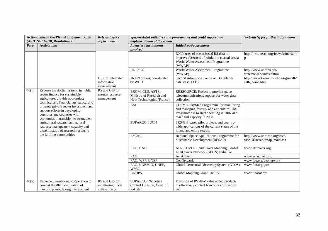
40(j) Reverse the declining trend in public sector finance for sustainable agriculture, provide appropriate technical and financial assistance, and promote private sector investment and support efforts in developing countries and countries with economies in transition to strengthen agricultural research and natural resource management capacity and dissemination of research results to the farming communities
RS and GIS for natural resource management
UNOPS
Global Mapping Grant Facility www.unosat.org
40(n) Enhance international cooperation to combat the illicit cultivation of narcotic plants, taking into account
RS and GIS for monitoring illicit cultivation of
SUPARCO/ Narcotics Control Division, Govt. of Pakistan
Provision of RS data/ value added products to effectively control Narcotics Cultivation etc.

33
Action items in the Plan of Implementation (A/CONF.199/20, Resolution 2)
Space-related initiatives and programmes that could support the implementation of the action
Para. Action item
Relevant space applications
Agencies / institution(s) involved
Initiatives/Programmes
Web-site(s) for further information
their negative social, economic and environmental impacts
narcotic plants FAO, UNESCO, UNEP, WMO
Global Terrestrial Observing System (GTOS)
www.fao.org/gtos
- Desertification - SPOT Image SPOT satellite vegetation instrument ASI – CNES – INTA - SNSB
ORFEO project
ASI COSMO-SkyMed Programme for ecological monitoring. The Programme is to start operating in 2007 and reach full capacity in 2008.
SUPARCO Monitoring desertification using RS data Technical Cooperation Programme http://www.wmo.ch/web/tco/
TCOHome.html WMO
WMO Space Programme http://www.wmo.ch/hinsman/ satsun.html
41(a) Mobilize adequate and predictable financial resources, transfer of technologies and capacity-building at all levels
EO satellites for monitoring desertification
FAO, UNESCO, UNEP, WMO
Global Terrestrial Observing System (GTOS) www.fao.org/gtos
SPOT Image SPOT satellite vegetation instrument ASI – CNES – INTA - SNSB
ORFEO project
ASI COSMO-SkyMed Programme for ecological monitoring. The Programme is to start operating in 2007 and reach full capacity in 2008.
41(b) Formulate national action programmes to ensure timely and effective implementation of the Convention and its related projects, with the support of the international community, including through decentralized projects at the local level
EO satellites for monitoring desertification
WMO WMO Space Programme http://www.wmo.ch/hinsman /satsun.html
EADS – Geomatics – Cemagref – CESBIO – ONF - Media France, Ministry of Research and New Technologies (France)
METIS project on forest management and control
41(d) Integrate measures to prevent and combat desertification as well as to mitigate the effects of drought through relevant policies and programmes, such as land, water and forest management, agriculture, rural development, early warning systems,
RS and GIS for land, water and forest management, early warning systems, environment monitoring and Hungarian Meteorological
Service Surface parameters – climate change modeling (ALADIN – HU)

34
Action items in the Plan of Implementation (A/CONF.199/20, Resolution 2)
Space-related initiatives and programmes that could support the implementation of the action
Para. Action item
Relevant space applications
Agencies / institution(s) involved
Initiatives/Programmes
Web-site(s) for further information
ASI COSMO-SkyMed Programme for ecological monitoring, monitoring and managing coastlines and marine and inland waters, including ice monitoring, and for monitoring and managing forestry and agriculture. The Programme is to start operating in 2007 and reach full capacity in 2008.
SUPARCO RS Application Program ESCAP Regional Space Applications Programme for
Sustainable Development (RESAP) http://www.unescap.org/icstd/ SPACE/resap/resap_main.asp
Hydrology and Water Resources Management Programme
http://www.wmo.ch/web/homs/ 1stpage.html
WMO
WMO Space Programme http://www.wmo.ch/hinsman/ satsun.html
FAO, WFP, UNEP GeoNetwork www.fao.org/geonetwork
assessment
UNESCO World Water Assessment Programme (WWAP)
http://www.unesco.org/water/ wwap/index.shtml
environment, energy, natural resources, health and education, and poverty eradication and sustainable development strategies
RS and GIS information as decision making tools for policy makers and managers; development of forecasting and management models; training and research as a key to poverty alleviation
UNESCO Cross-cutting project “Application of Remote Sensing for Integrated Management of Ecosystems and Water Resources in Africa”
http://ioc.unesco.org/goos/africa/cross-cutting.htm
41(e) Provide affordable local access to EO satellites and SPOT Image, Eutelsat SPOT satellite, Eutelsat fleet

35
Action items in the Plan of Implementation (A/CONF.199/20, Resolution 2)
Space-related initiatives and programmes that could support the implementation of the action
Para. Action item
Relevant space applications
Agencies / institution(s) involved
Initiatives/Programmes
Web-site(s) for further information
ASI COSMO-SkyMed Programme for ecological monitoring. The Programme is to start operating in 2007 and reach full capacity in 2008.
ESCAP Regional Space Applications Programme for Sustainable Development (RESAP)
http://www.unescap.org/icstd/ SPACE/resap/resap_main.asp
World Weather Watch Programme http://www.wmo.ch/web/ www/www.html
WMO
WMO Space Programme http://www.wmo.ch/hinsman/ satsun.html
information to improve monitoring and early warning related to desertification and drought
satellite communications to improve monitoring and early warning
FAO, WFP, UNEP
GeoNetwork www.fao.org/geonetwork
ASI COSMO-SkyMed Programme for ecological monitoring. The Programme is to start operating in 2007 and reach full capacity in 2008.
41(g) Improve the sustainability of grassland resources through strengthening management and law enforcement and providing financial and technical support by the international community to developing countries
RS for the management of grassland resources
ESCAP Regional Space Applications Programme for Sustainable Development (RESAP)
http://www.unescap.org/icstd/ SPACE/resap/resap_main.asp
- Mountain ecosystems - ASA and Austrian Federal Ministry for Transport, Innovation and Technology funded projects: JR, GEOSPACE, ENVEO (Austria)
“Management of Natural Resources in Alpine Regions by Advanced Remote Sensing Techniques”, Project within the framework of the Austrian Space Application Programme
42(b) Implement programmes to address, where appropriate, deforestation, erosion, land degradation, loss of biodiversity, disruption of water flows and retreat of glaciers
RS for monitoring deforestation, erosion, land degradation, loss of biodiversity, etc.
EADS – Geomatics – Cemagref – CESBIO –ONF - Media France, French Ministry of Research and New Technologies (France)
METIS project on forest management and control

36
Action items in the Plan of Implementation (A/CONF.199/20, Resolution 2)
Space-related initiatives and programmes that could support the implementation of the action
Para. Action item
Relevant space applications
Agencies / institution(s) involved
Initiatives/Programmes
Web-site(s) for further information
ASI COSMO-SkyMed Programme for ecological monitoring, monitoring and managing coastlines and marine and inland waters, including ice monitoring, and for monitoring and managing forestry and agriculture. The Programme is to start operating in 2007 and reach full capacity in 2008.
ESCAP Regional Space Applications Programme for Sustainable Development in Asia and the Pacific (RESAP)
http://www.unescap.org/icstd/ SPACE/resap/resap_main.asp
WMO WMO Space Programme http://www.wmo.ch/hinsman/ satsun.html
Man and Biosphere (MAB) programme and its Biosphere Reserve Integrated Monitoring (BRIM) initiative
http://www.unesco.org/mab/ index.htm
Programme for Community Multimedia Centre
http://portal.unesco.org/ ci/ev.php?URL_ID=1263& URL_DO=DO_TOPIC& URL_SECTION=201& reload=1075742490
UNESCO
Cross-cutting project “Application of Remote Sensing for Integrated Management of Ecosystems and Water Resources in Africa”
http://ioc.unesco.org/goos/africa/cross-cutting.htm
Programme for Community Multimedia Centers
42(d) Implement programmes to promote diversification and traditional mountain economies, sustainable livelihoods and small-scale production systems, including specific training programmes and better access to national and international markets, communications and transport planning, taking into account the particular sensitivity of mountains
Satellite communications for better access to markets
UNESCO
Man and Biosphere (MAB) programme and its Biosphere Reserve Integrated Monitoring (BRIM) initiative
- Biodiversity-

37
Action items in the Plan of Implementation (A/CONF.199/20, Resolution 2)
Space-related initiatives and programmes that could support the implementation of the action
Para. Action item
Relevant space applications
Agencies / institution(s) involved
Initiatives/Programmes
Web-site(s) for further information
CLS Data collection using Argos beacons ASI COSMO-SkyMed Programme for ecological
monitoring. The Programme is to start operating in 2007 and reach full capacity in 2008.
SUPARCO, WWF Conservation of precious wetland resources in the country through the integration of SRS/GIS databases.
Man and Biosphere (MAB) programme and its Biosphere Reserve Integrated Monitoring (BRIM) initiative
http://www.unesco.org/mab/ index.htm
RS and GIS for monitoring biodiversity at World Heritage sites
UNESCO
Use of space technology for monitoring World Heritage sites
http://whc.unesco.org/nwhc/ pages/home/pages/homepage.htm
44(f) Promote concrete international support and partnership for the conservation and sustainable use of biodiversity, including in ecosystems, at World Heritage sites and for the protection of endangered species, in particular through the appropriate channelling of financial resources and technology to developing countries and countries with economies in transition;
RS and GIS information as decision making tools for policy makers and managers; development of forecasting and management models; training and research as a key to poverty alleviation
UNESCO Cross-cutting project “Application of Remote Sensing for Integrated Management of Ecosystems and Water Resources in Africa”
http://ioc.unesco.org/goos/africa/cross-cutting.htm
- Forest management - “Testing of Novel Earth Observation Systems for Supporting Quality Control Activities required by the Kyoto-Protocol”
45(f) Create and strengthen partnerships and international cooperation to facilitate the provision of increased financial resources, the transfer of environmentally sound technologies, trade, capacity-building, forest law
RS and GIS for integrated land and resource management
ASA, Austrian Federal Ministry for Transport, Innovation and Technology and European Space Agency (ESA) funded projects: GEOVILLE, ARCS and TU
Acquisition of LULUCF3-Parameters (Land Use, Land Use Change and Forestry – LULUCF)

38
Action items in the Plan of Implementation (A/CONF.199/20, Resolution 2)
Space-related initiatives and programmes that could support the implementation of the action
Para. Action item
Relevant space applications
Agencies / institution(s) involved
Initiatives/Programmes
Web-site(s) for further information
Project within the framework of the Austrian Space Application Programme
Wien – IPF (Austria)
A GeoVille led Kyoto project focusing on LULUCF project activities funded by ESA-ESRIN
EADS – Geomatics – Cemagref – CESBIO – ONF - Media France, Ministry of Research and New Technologies (France)
METIS project on forest management and control
ASI COSMO-SkyMed Programme for monitoring and managing forestry and agriculture. The Programme is to start operating in 2007 and reach full capacity in 2008.
SUPARCO, Forestry department, Govt. of Pakistan
Detailed Forest Cover Mapping of Pakistan using High Resolution SPOT XS Data
FAO, WFP, UNEP GeoNetwork www.fao.org/geonetwork Man and Biosphere (MAB) programme and its Biosphere Reserve Integrated Monitoring (BRIM) initiative
UNESCO
Cross-cutting project “Application of Remote Sensing for Integrated Management of Ecosystems and Water Resources in Africa”
http://ioc.unesco.org/goos/africa/cross-cutting.htm
enforcement and governance at all levels and integrated land and resource management to implement sustainable forest management, including the proposals for action of the Intergovernmental Panel on Forests/Intergovernmental Forum on Forests
GIS for integrated information management
16 UN organs, coordinated by WHO
Second Administrative Level Boundaries data set (SALB)
http://www3.who.int/whosis/gis/salb/salb_home.htm
- Mining - 46(c) Foster sustainable mining practices
through the provision of financial, technical and capacity-building
RS for detection and management of minerals
SUPARCO, Geological Survey of Pakistan
Provision of relevant SRS data and consultation to government agencies.
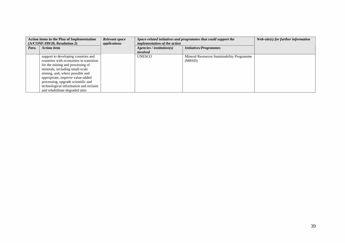
39
Action items in the Plan of Implementation (A/CONF.199/20, Resolution 2)
Space-related initiatives and programmes that could support the implementation of the action
Para. Action item
Relevant space applications
Agencies / institution(s) involved
Initiatives/Programmes
Web-site(s) for further information
support to developing countries and countries with economies in transition for the mining and processing of minerals, including small-scale mining, and, where possible and appropriate, improve value-added processing, upgrade scientific and technological information and reclaim and rehabilitate degraded sites
UNESCO Mineral Resources Sustainability Programme (MRSD)