iv.g land use - department of city planning land... · 130 since the ccnsp requires that the...
TRANSCRIPT

City of Los Angeles New Century Plan State Clearinghouse No. 2006061096 March 2008
Page 380
PRELIMINARY WORKING DRAFT – Work in Progress
IV. ENVIRONMENTAL IMPACT ANALYSIS G. LAND USE
1. INTRODUCTION
This section provides an analysis of the consistency of the proposed project with land use regulations that guide development of the project site and also evaluates the relationship of the project with surrounding land uses.
2. ENVIRONMENTAL SETTING
a. Existing Conditions and Background
The project site is located within the West Los Angeles community of the City of Los Angeles, approximately 8.5 miles west of downtown Los Angeles and 6 miles northeast of the Pacific Ocean. As described in Section II, Project Description, of this Draft EIR, the approximately 22-acre project site consists of the existing Westfield Century City Shopping Center addressed as 10250 Santa Monica Boulevard, and two adjacent properties: a 13-story office building located at 1801 Avenue of the Stars and a five-story office building located at 1930 Century Park West. The project site is bounded to the north by Santa Monica Boulevard (a heavily traveled corridor that traverses the City), Avenue of the Stars to the east, Constellation Boulevard to the south, and Century Park West to the west.124 The area is served by three major arterials, Santa Monica Boulevard, Olympic Boulevard and Pico Boulevard, and has nearby access to the San Diego Freeway (I-405) and the Santa Monica Freeway (I-10).
The site lies within the commercial core of Century City, a highly urbanized area generally characterized by mid- to high-rise office buildings, hotels, entertainment, retail, and residential uses. This dense regional center physically contrasts with surrounding development, which consists primarily of low-rise commercial and residential uses.
124 The site is actually located on a northwest-southeast axis, with Santa Monica Boulevard to the northwest.
Directions have been simplified for ease of reference.

IV.G. Land Use
City of Los Angeles New Century Plan State Clearinghouse No. 2006061096 March 2008
Page 381
PRELIMINARY WORKING DRAFT – Work in Progress
(1) Project Site
The Westfield Century City Shopping Center was developed in the mid-1960s. The center provides a variety of uses, including numerous retail stores, a grocery store, restaurants, and a multi-screen cinema. The shopping center has expanded and been upgraded over the years, with various approvals to expand shopping center uses and allow specific conditional uses. In 1988, the City granted a Conditional Use Permit (CUP) authorizing the sale and dispensing of alcoholic beverages for consumption on the shopping center premises, in conjunction with 18 restaurants, cafes and delicatessens.125 As part of this CUP, Conditions of Approval were specified and agreed to by the shopping center. More recently in 2001, a Plan Approval was granted to expand the shopping center by 71,700 square feet, with modified parking access.126 Although approved for a 71,700 square foot expansion, the actual project represented a net addition of only 63,075 square feet, aside from relocation of the existing AMC theater (which included 90,578 square feet and no increase in the number of theater seats) as acknowledged by the City in a covenant and agreement recorded in 2004.127 These improvements have been completed and include a relocated 15-screen state-of-the-art cinema adjacent to Macy’s in the southwestern portion of the site (which opened in December 2005). Westfield’s improvements have also included a new alfresco-style retail/dining terrace located north of the new cinema (which opened in November 2005), which added 1,308 square feet of space to the second floor food court area, as acknowledged by the City in another covenant and agreement recorded in 2005.128 Westfield has also expanded and renovated the Gelson’s grocery store and added a new luxury retail area along Century Park West, most of which was completed in December 2006. In addition, access improvements along Santa Monica Boulevard have also been recently completed. With these recently completed improvements, Westfield Century City Shopping Center includes an estimated 742,815 square feet of retail and restaurant uses, as well as 90,578 square feet of cinema uses with 3,074 seats. In addition, approximately 2,630 parking spaces are provided within the site within two semi-subterranean levels below the shopping center uses.129 The heights of the existing structures within the shopping center range from one story to four stories (approximately 16 to 73 feet above the shopping center plaza, which ranges from 7 to 11 feet above the adjacent street grade).130
125 City of Los Angeles Case No. CF 88-0469, approved May 6, 1988. 126 City of Los Angeles Case No. ZA 2001-1375(CUB)(SPR), approved August 14, 2001. 127 Master Covenant and Agreement No. 04-1418128. 128 Master Covenant and Agreement No. 05-1826827. 129 The 2,630 parking spaces within the shopping center provide 295 more parking spaces than required by the City
of Los Angeles. 130 Since the CCNSP requires that the heights of structures within the C2-1VL portion of the shopping center be
measured from plaza level, the heights of other existing buildings within the shopping center have also been measured from plaza level to maintain consistency.
IV.G. Land Use
City of Los Angeles New Century Plan State Clearinghouse No. 2006061096 March 2008
Page 382
PRELIMINARY WORKING DRAFT – Work in Progress
The layout of Westfield Century City Shopping Center has an open-air character, with aisles of retail bays surrounding two three-story department stores, arranged around a grid system of outdoor pedestrian walkways. The new theater building has a multi-story glass façade that overlooks a small outdoor plaza below, and the adjacent second floor outdoor dining terrace adds to the outdoor pedestrian-friendly quality of the center. The walkways through the shopping center connect to a broader pedestrian system through Century City, specifically connecting to a pedestrian bridge (discussed below) that spans Avenue of the Stars, as well as to an at-grade walkway south of the project site.
The remainder of the project site consists of the two adjacent properties at 1801 Avenue of the Stars and 1930 Century Park West. The 1801 Avenue of the Stars property, located on the southwest corner of Santa Monica Boulevard and Avenue of the Stars, currently consists of approximately 298,718 square feet of office uses within a 13-story building, with 607 parking spaces in four subterranean levels. A pedestrian bridge across Avenue of the Stars connects to this property. The property at 1930 Century Park West, located on the northeast corner of Century Park West and Constellation Boulevard, includes a building comprised of approximately 62,246 square feet of office uses within five stories. Below this building is a two level subterranean parking garage that together with a small surface parking lot provides 161 parking spaces. Additional discussion regarding the development and history of these buildings and Century City as a whole is provided in Section IV.C, Historic Resources.
(2) Surrounding Uses
Land uses in the project area include a variety of primarily mid- and high-rise office, hotel, entertainment, hospital, and residential uses, as shown in Figure 47 on page 383. Within the same city block as the project site along Avenue of the Stars are a 20-story office building at 1901 Avenue of the Stars and the 39-story SunAmerica office building and associated parking structure at 1999 Avenue of the Stars.
To the north of the project site across Santa Monica Boulevard are commercial and multi-family uses as well as the Los Angeles Country Club. Single-family residential uses are located further to the north of these uses.
Uses directly south of the project site include the 19-story Century Plaza Hotel and the 36-story MGM building. In addition, a new approximately 480-foot high building with 147 condominium units has been approved to replace the recently demolished 30-story St. Regis Hotel located just south of the Century Plaza Hotel. In addition, this block includes the Century Woods Condominium complex, located at the northeast corner of Century Park West and Olympic Boulevard. Further to the south across Olympic Boulevard are the 39-story Fox Plaza office building, the Park Hyatt Hotel, and 20th Century Fox Studio.

����������
�����
���� �����
���� ���� ���
���������
������
�������
��
������ �! "� � ���
��� � �����
� ���������
�#� ����
������� ���"���
��# ����$��%&�
��� ��� ��' ���
����(��)���
��� ��*���������� ��+
������� ���,����,�$%�%�$�
���,�$%�%�$���,�� &������&�%��
!�-���
!�-���,%��
������
���� ���
� �
������
�� �����
� �
.///�0���� �1 (� �����
�%�*�2!�$%����%,���%�
�%�*�2!�$%����%,���%�
��$$
��&%�
��$$��&%�
���%2!�$%�
���%,���%�
34//�0���� �1 (� �����
35/3�0���� �1 (� �����
35//�0���� �1 (� �����
3//67����� ���%&�
34/3������� ��8
����
3/393 ��������%����$,�$%�%�$�
:�))��0�,;
��
��$$
��&%�
��$$
��&%�
���%2!�$%�
���%,���%�
��������������������� ���
�
��������
���������� ��������������
����������
���������������������������������������������������������������
��!���"������#���#"������#
���������# ���

IV.G. Land Use
City of Los Angeles New Century Plan State Clearinghouse No. 2006061096 March 2008
Page 384
PRELIMINARY WORKING DRAFT – Work in Progress
To the southeast of the project site at 2000 Avenue of the Stars is a 15-story, approximately 790,000 square foot mixed-use office building that has recently been completed. In addition, the two 44-story Century Plaza Towers are located on the same block fronting Century Park East. At approximately 849 feet above mean sea level (amsl), the Century Plaza Towers are the tallest structures in the project vicinity.
Across Avenue of the Stars to the east are a 13-story office building at 1800 Avenue of the Stars, a 28-story office building at 1900 Avenue of the Stars, and a two-story commercial building at 1950 Avenue of the Stars. Also within that block on Constellation Boulevard are a small building located at 10131 Constellation Boulevard, an office complex with twin 23-story structures known as Watt Plaza, a 27-story office building at 10076 Santa Monica Boulevard, a 27-story office building 1801 Century Park East, and associated surface and structured parking lots. The buildings located at 10131 Constellation Boulevard and 1950 Avenue of the Stars are proposed for demolition and replacement with 483 condominium units housed in two 47-story (570-foot) towers and a 12-story (135-foot) building, which have been approved by the City.131
To the west of the project site are multi-family and single-family residential uses. These uses are separated from the site by Century Park West and a fence with mature landscaping that runs along the western portion of Century Park West in the vicinity of the site.
Other residential uses in the area include high-density multi-family residential uses further south of the project site near Olympic Boulevard. As shown in Figure 47, these residential uses include the Century Wood Condominiums, the Park Plaza Condominiums, the Century Hill Condominiums, and the Century Park East Condominiums. The Century Towers, two 28-story residential towers, are also located further to the south of the site at the northeast corner of Avenue of the Stars and Pico Boulevard. The jurisdictional boundary between the City of Los Angeles and Beverly Hills is located east of Century Park East and forms the eastern boundary of Century City. Beverly Hills High School is located adjacent to the jurisdictional boundary, with a residential neighborhood located east of the school. Low-rise commercial uses are located to the north of the High School along Santa Monica Boulevard. To the south of the High School and south of Olympic Boulevard are multi-family residences and Roxbury Recreation Center.
Public improvements to Santa Monica Boulevard have also recently been completed in the project area. The Santa Monica Boulevard Transit Parkway Project, consisting of the reconfiguration of Santa Monica Boulevard between I-405 and the Beverly Hills city limit (near Wilshire Boulevard), has merged Santa Monica Boulevard and Little Santa Monica (the parallel roadway to the immediate south), resulting in three travel lanes in each direction and neighborhood access roads along the north and south of the main roadway. This project has also 131 City of Los Angeles Case No. ENV-2004-6269-EIR.

IV.G. Land Use
City of Los Angeles New Century Plan State Clearinghouse No. 2006061096 March 2008
Page 385
PRELIMINARY WORKING DRAFT – Work in Progress
provided High Occupancy Vehicle (HOV) on-ramps to I-405 northbound and southbound, as well as traffic signal, median, street lighting, landscaping, bicycle lane, and public transportation improvements.
b. Regulatory Framework
(1) Local Plans and Applicable Policies
(a) City of Los Angeles General Plan
The General Plan of the City of Los Angeles is a policy document originally adopted in 1974 that serves as a comprehensive, long-term plan for future development. The General Plan sets forth goals, objectives and programs to guide land use policies and to meet the existing and future needs of the community, while integrating a range of State-mandated elements including Land Use, Transportation, Noise, Safety, Housing, and Open Space/Conservation. Two major components of the General Plan are the Citywide General Plan Framework Element and the Land Use Element, which is comprised of 35 local area plans known as Community Plans that guide land use at the local level. Relative to the project site, the General Plan includes the West Los Angeles Community Plan (Community Plan), which guides land use at the community level, and the Century City North Specific Plan (CCNSP), which contains site-specific land use constraints for new development. These documents are discussed further below.
(i) The Framework Element of the General Plan
The Framework Element of the General Plan (General Plan Framework), adopted in December 1996 and readopted in August 2001, presents a strategy for long-term growth that sets a context to guide amendments of the City's Community Plans, zoning ordinances, and other pertinent programs. The General Plan Framework defines Citywide policies for land use, housing, urban form and neighborhood design, open space and conservation, economic development, transportation, infrastructure and public services. General Plan Framework land use policies are further guided at the community level through the Community Plans and Specific Plans.
The General Plan Framework Land Use Chapter designates Districts (i.e., Neighborhood Districts, Community Centers, Regional Centers, Downtown Centers, and Mixed-Use Boulevards) throughout the City and provides policies applicable to each District to support the vitality of the City’s residential neighborhoods and commercial centers. Century City is designated as a Regional Center under the General Plan Framework and, as such, is designated
IV.G. Land Use
City of Los Angeles New Century Plan State Clearinghouse No. 2006061096 March 2008
Page 386
PRELIMINARY WORKING DRAFT – Work in Progress
as a high-density area and a focal point of regional commerce, identity, and activity.132 Table 3-1 of the Framework lists the following as typical uses within a Regional Center:
• Corporate and professional offices, retail commercial (including malls), personal services, eating and drinking establishments, telecommunications centers, entertainment, major cultural facilities, hotels, and similar uses;
• Mixed use structures integrating housing with commercial uses;
• Multi-family housing (independent of commercial);
• Major transit hub;
• Inclusion of small parks and other community-oriented activity facilities.
The density of Regional Centers also supports the development of a comprehensive and inter-connected network of public transit and services. In addition, the General Plan Framework's Land Use Chapter encourages retention of the City's stable residential neighborhoods and proposes incentives to encourage the location of future growth in neighborhood districts, commercial and mixed use centers, along boulevards, industrial districts, and in proximity to transportation corridors and transit stations. The General Plan Framework Housing Chapter seeks to contribute to stable, safe, and livable neighborhoods and improve access to jobs and neighborhood services.
The Urban Form and Neighborhood Design Chapter of the General Plan Framework establishes the goals of creating: a livable city for existing and future residents; a city that is attractive to future investment; and a city of interconnected, diverse neighborhoods that builds on the strength of those neighborhoods and functions at both the neighborhood and Citywide scales.133 The General Plan Framework does not directly address the design of individual neighborhoods or communities, but embodies general neighborhood design and implementation programs that guide local planning efforts and lay a foundation for the updating of community plans. With respect to neighborhood design, the Urban Form and Neighborhood Design Chapter encourages growth in areas that have a sufficient base of both commercial and residential development to support transit service.
132 The Citywide General Plan Framework, Los Angeles City Planning Department, Figure 3-3, Long Range Land
Use Diagram: West/Coastal Los Angeles, re-adopted by the City Council on August 8, 2001. 133 “Urban form” refers to the general pattern of building heights and development intensity and the structural
elements that define the City physically, such as natural features, transportation corridors, activity centers, and focal elements. “Neighborhood design” refers to the physical character of neighborhoods and communities within the City.

IV.G. Land Use
City of Los Angeles New Century Plan State Clearinghouse No. 2006061096 March 2008
Page 387
PRELIMINARY WORKING DRAFT – Work in Progress
The Open Space and Conservation Chapter of the General Plan Framework calls for the use of open space to enhance community and neighborhood character. The policies of this chapter recognize that there are communities where open space and recreation resources are currently in short supply, and therefore suggests that vacated railroad lines, drainage channels, planned transit routes and utility rights-of-way, or pedestrian-oriented streets and small parks, where feasible, might serve as important resources for serving the open space and recreation needs of residents.
The Economic Development Chapter of the Framework seeks to provide physical locations necessary to attract continued economic development and investment to targeted districts and centers. Goals, objectives, and policies focus on retaining commercial uses, particularly within walking distance of residential areas, and promoting business opportunities in areas where growth can be accommodated without encroaching on residential neighborhoods.
The Transportation Chapter of the General Plan Framework includes proposals for major improvements to enhance the movement of goods and to provide greater access to major intermodal facilities. The Transportation Chapter acknowledges that the quality of life for every citizen is affected by the ability to access work opportunities and essential services, affecting the City’s economy, as well as the living environment of its citizens.134 The Transportation Chapter stresses that transportation investment and policies will need to follow a strategic plan, including capitalizing on currently committed infrastructure and adoption of land use policies to better utilize committed infrastructure. The Transportation Chapter of the General Plan Framework is implemented through the Transportation Element of the General Plan.
Applicable policies and a consistency analysis of the project with each of the General Plan Framework chapters are provided in Table 22 on page 406 in the impact analysis below.
(ii) Transportation Element of the General Plan
The Transportation Element of the General Plan, adopted September 8, 1999, presents a guide to the further development of a Citywide transportation system and the efficient movement of people and goods. The Transportation Element addresses motorized and non-motorized transportation, including highways, scenic highways, rail transit, goods movement systems, pedestrian priority street segments, and bikeways. The Transportation Element sets forth street designations and related standards, as well as selection and performance standard criteria for each designation. The City of Los Angeles Bicycle Plan is a component of the Transportation Element. Under the Bicycle Plan, Santa Monica Boulevard and Avenue of the Stars are
134 The Citywide General Plan Framework, Los Angeles City Planning Department, re-adopted by the City Council
on August 8, 2001, page 8-2.

IV.G. Land Use
City of Los Angeles New Century Plan State Clearinghouse No. 2006061096 March 2008
Page 388
PRELIMINARY WORKING DRAFT – Work in Progress
designated as Class II bicycle routes in the Westside Geographical Area (Map B2). The bikeway on Santa Monica Boulevard is planned to tie into a Class I bikeway at Sepulveda Boulevard. The Avenue of the Stars bikeway ties into a Class I bikeway south of Century City, via Motor Avenue.
(iii) West Los Angeles Community Plan
The land use policies and standards of the General Plan Elements and the General Plan Framework are implemented at the local level through the community planning process (i.e., the Community Plan). Pursuant to state law, the Community Plan is consistent with the other elements and components of the General Plan. The intent of the Community Plan is to promote an arrangement of land uses, circulation, and services that will encourage and contribute to the economic, social and physical health, safety, welfare, and convenience of the people who live in the community. Development on the project site is subject to the West Los Angeles Community Plan, last updated on July 27, 1999. The Community Plan sets forth goals, objectives, policies, and programs to meet the needs of the West Los Angeles community through the year 2010. As shown in Figure 48 on page 389, the Community Plan designates the entire project site and much of the surrounding portions of Century City for Regional Commercial uses.
The primary issues addressed in the Community Plan that pertain to commercial uses deal with land use compatibility concerns such as visual cohesiveness and continuity along commercial frontages, architectural quality, visual identity, signage, landscaping, streetscape improvements, and compatibility with surrounding development in terms of building height, scale, and architecture. The Community Plan also encourages pedestrian- and neighborhood-friendly commercial development, with convenient access, sufficient parking, and appropriate scale. Opportunities for development that support the Community Plan’s goals are also identified and include: implementation of the CCNSP (discussed below), which regulates land use as well as vehicular traffic in the project area; the Santa Monica Boulevard Transit Parkway Project (discussed above) which is currently underway and will help improve the visual character of the area; and the potential for mixed use development designed to promote pedestrian activity, reduce traffic congestion, and increase economic viability.
Community Plan issues that address residential development include: (1) the need to protect low-density residential uses from encroachment from spillover traffic or commercial off-street parking; (2) usable open space and recreational facilities in multiple-family housing; (3) a lack of transition in scale, density, and character between commercial and industrial uses and single- and multi-family areas; and (4) the need to coordinate new development with the availability of public infrastructure.135 Local characteristics supporting these aims include the
135 West Los Angeles Community Plan, Los Angeles City Planning Department, updated July 27, 1999, pages I-2
and I-3.

����������
����������
�������
����� �����������������������������������������
�
�������
���������������������
����������������������
��������������

IV.G. Land Use
City of Los Angeles New Century Plan State Clearinghouse No. 2006061096 March 2008
Page 390
PRELIMINARY WORKING DRAFT – Work in Progress
area’s social and economic diversity; unique architectural characteristics; proximity of cultural and intellectual institutions such as museums, theaters, and educational facilities, as well as recreational amenities; proximity to Los Angeles International Airport; access to major freeways and employment centers in downtown Los Angeles and Century City; and the potential for mixed use development along Santa Monica, Wilshire, and Sawtelle Boulevards.
The West Los Angeles Community Plan also describes transportation as a significant land use issue, citing as problems acute traffic congestion on major roadways; insufficient vehicular links between residential areas and commercial, retail, and recreational facilities; inadequate alternative modes of transportation; and spillover parking from commercial areas into residential areas. The West Los Angeles Transportation Improvement and Mitigation Specific Plan (discussed further below) is described as a transportation-related Specific Plan that serves to mitigate the impact of new development on the circulation system through transportation impact fees and project phasing. Transportation opportunities also described in the Community Plan include improved and expanded bicycle lanes, implementation of project-specific traffic mitigation measures, and the Santa Monica Boulevard Transit Parkway Project.
The Community Plan sets forth goals and objectives to maintain the community’s distinctive character by preserving and enhancing the area’s positive characteristics and maximizing development opportunities around future transit systems while minimizing adverse impacts. The goals, objectives, and policies that apply to designated commercial properties, such as the project site, as well as residential uses, which are also proposed under the project, are provided below in Table 24 on page 416 within the Project Impact Analysis.
Chapter V (Urban Design) of the Community Plan addresses community design and landscaping in public spaces and rights-of-way. Design standards are established to ensure that visual continuity is maintained along commercial streetscapes, pedestrian and economic activity is promoted through good design, and that quality of life and neighborhood identity are enhanced through architectural design. Relative to commercial uses, the design standards focus on orienting structures toward main commercial streets; avoiding pedestrian/vehicular conflicts; promoting pedestrian-scaled development with sufficient articulation to provide visual interest; screening equipment from public view; integrating parking structure design with building design; buffering residential uses from parking structures; and providing sufficient lighting for safety while minimizing light spillover. The residential design standards similarly address visual character and landscaping, as well as open space. Finally, landscaping guidelines are provided for streetscapes, public spaces, and rights-of-way. Specific improvements are recommended and pertain to visual entryways, streetscape design, street trees, street furniture, street lighting, sidewalks, signage, and public open spaces and plazas.

IV.G. Land Use
City of Los Angeles New Century Plan State Clearinghouse No. 2006061096 March 2008
Page 391
PRELIMINARY WORKING DRAFT – Work in Progress
While the Community Plan does not mandate mixed-use projects, it encourages mixed use in commercially designated areas that have the potential for such uses.136 The intent of mixed-use development is to provide housing in proximity to jobs and services, to reduce vehicular trips, congestion, and air pollution, to provide for rental housing, and to stimulate pedestrian-oriented areas. The Community Plan states that the mixed-use concept could accommodate separate commercial and residential structures in the same block.137
(iv) Century City North Specific Plan
The project site also lies within the Century City North Specific Plan area, as shown in Figure 49 on page 392. Adopted in November 1981, the CCNSP was designed to guide development and redevelopment in the area and to ensure adequate transportation and other public facilities for the high-intensity center of Century City, while addressing compatibility with nearby low-density residential areas. The CCNSP establishes a phasing strategy, consisting of two development phases, to assure orderly development and provide adequate infrastructure with build-out of the existing zoning for the area. The CCNSP limits development in Century City through the assignment of development rights called Cumulative Automobile Trip Generation Potential (CATGP) Trips to parcels within the CCNSP.138 139 The first phase of the CCNSP (Phase I) allowed development until projects had used a certain number of development rights or CATGP Trips and required specific street dedications and roadway improvements on Avenue of the Stars, Century Park East, Century Park West, Constellation Boulevard, Pico Boulevard, and Santa Monica Boulevard. The CCNSP’s second phase of development began when building permits had been issued for projects generating 15,225.606 CATGP Trips and when all public improvements set forth in the CCNSP Ordinance were completed. Pursuant to City of Los Angeles Case No. CF 98-0672, all Phase I improvements have been completed and the CCNSP is now acting in its second phase.
Projects developed during Phase II are limited to three sources of CATGP Trips. First, a project may use the original Phase I CATGP Trips assigned by the City to parcels in 1981. Second, a project may use Replacement CATGP Trips generated when uses on a parcel are changed or buildings on that parcel are demolished, since a change of use or demolition of these 136 West Los Angeles Community Plan, Los Angeles City Planning Department, updated July 27, 1999, page III-6. 137 Ibid. 138 Cumulative Automobile Trip Generation Potential (CATGP) is defined as “the cumulative total daily Trips
generated by all Projects on commercially zoned lots within the Specific Plan Area for which building permits are issued subsequent to November 15, 1981,” based on CATGP Trip generation factors specified within the Specific Plan. (Century City North Specific Plan, Section 2, page 2.)
139 CATGP Trips are defined as a “unit of real property development rights pursuant to this Specific Plan and means a calculation of daily arrivals at and daily departures from a building or structure by motor vehicles of four or more wheels. The number of Trips generated by any Project or existing building or structure shall be calculated utilizing the table set forth in the definition of Cumulative Automobile Trip Generation Potential.” (Century City North Specific Plan, Section 2, page 5.)

����������
��������������������� ��������������
����� ���������������������������������������������� ��!"#$%&$
�
����������
���������'�����������

IV.G. Land Use
City of Los Angeles New Century Plan State Clearinghouse No. 2006061096 March 2008
Page 393
PRELIMINARY WORKING DRAFT – Work in Progress
buildings frees the parcel for replacement development.140 Third, a project may have CATGP Trips transferred to the project site from another parcel within the Century City North Specific Plan. A limited number of CATGP Trips may also be transferred from the Century City South Specific Plan area to lots within the Century City North Specific Plan area. In order for a transfer of CATGP Trips to occur, the Director of City Planning must certify in writing that the transfer conforms to the provisions of the CCNSP.141
Section 7 of the CCNSP, entitled Shopping Center, applies specifically to the Westfield Century City property. The CCNSP prohibits fast food restaurants on-site, stipulates that retail commercial development may include incidental office space, details a CATGP Trip rate and limitations for CATGP Trips transferred from the shopping center to another lot for retail commercial uses. The CCNSP also specifies that the first 3,516.059 CATGP Trips resulting from building demolition on-site must be used for retail commercial uses (unless a specific City Council resolution is obtained). Based on the City’s August 1, 2007 Trip Allocation Chart, 278.605 CATGP Trips remain available within the shopping center, and 1,259.706 CATGP Replacement Trips are available on the 1930 Century Park West parcel. In addition, the City has acknowledged, through recorded covenants, that demolition of the existing development on the 1801 Avenue of the Stars and 1930 Century Park West parcels would result in an additional 4,182.052 and 871.451 CATGP Replacement Trips, respectively.142
Section 7 of the CCNSP also indicates that building heights within the C2-1VL-0 zone of the shopping center (i.e., the area along Century Park West) are limited to 45 feet as measured from the plaza level.143 Finally, this section specifies that 15,000 square feet of improved leasable floor area be made available for public use by the property owner. This requirement has been satisfied. Additionally, the commercially zoned properties within the CCNSP area are divided into “Core” and “Buffer” Areas, as shown in Figure 50 on page 394. The majority of the project site is located within the Core Area, which allows for a floor area ratio (FAR) of 6 to 1, while the western portion of the site (along Century Park West) is located within the Buffer Area and is subject to a FAR of 4.5 to 1.
As shown in Figure 49, the Century City North Specific Plan area includes a system of pedestrian walkways and crossings that collectively comprise a pedestrian corridor. The existing walkways through the shopping center link to this broader pedestrian system, specifically
140 CCNSP Sections 3.C.3 and 3.C.4 141 CCNSP Section 5. 142 Master Covenant and Agreement 20070696928; Master Covenant and Agreement 20070696886. 143 As discussed more fully in Section II. Project Description, the project is requesting an amendment to the CCNSP
which would expand the definition of “Shopping Center” to include 1801 Avenue of the Stars and 1930 Century Park West, and measure the heights of all structures located within the Shopping Center from the plaza level.

����������
����������������� ����������������������������������������������
����� ���������������������������������������������� ��!"#$%&$'
�
����������
���������(�����������

IV.G. Land Use
City of Los Angeles New Century Plan State Clearinghouse No. 2006061096 March 2008
Page 395
PRELIMINARY WORKING DRAFT – Work in Progress
connecting to a pedestrian bridge that spans Avenue of the Stars. The shopping center also connects to an at-grade walkway south of the project site via a pedestrian crosswalk at the southeast corner of the existing Macy’s building. Per Section 10 of the CCNSP, the project would be required to dedicate and maintain the pedestrian walkway through the site so as not to impede the designated pedestrian corridor. A list of design standards for the corridor is also specified; applicable standards are addressed in Section IV.A., Aesthetics/Visual Resources, of this Draft EIR.
As discussed in more detail below, since the proposed project falls within Phase II of the CCNSP, it would be required to obtain a Project Permit. Approval of a Project Permit requires written findings by the City Planning Commission, which are listed in Table 25 on page 423 within the project impact analysis.
(v) West Los Angeles Transportation Improvement and Mitigation Specific Plan
The project site is also located within the boundaries of the West Los Angeles Transportation Improvement and Mitigation Specific Plan (West LA TIMP), adopted March 8, 1997. The West LA TIMP is the transportation Specific Plan for a broad area between the Hollywood Hills to the north, the City of Santa Monica boundary to the west, the City of Culver City boundary to the south, and the City of Beverly Hills boundary to the east. The West LA TIMP is intended to regulate the phased development of land uses, insofar as the transportation infrastructure can accommodate such uses, and promote the development of coordinated and comprehensive transportation plans and programs with other jurisdictions and public agencies. The West LA TIMP is intended to provide a mechanism to fund specific transportation improvements that would mitigate transportation impacts generated by new development. A Transportation Impact Assessment (TIA) process and fee has been established for new development on any lot in the R3 or less restrictive zone. However, the West LA TIMP exempts multi-family projects from the TIA fee. The plan ensures that the public transportation facilities that will be constructed with these funds will significantly benefit the contributor.
Projects subject to this Specific Plan must also execute a Covenant with the City to implement a transportation demand management program satisfactory to the Department of Transportation which is substantially in conformance with the requirements outlined in the West LA TIMP. This requirement is intended to promote or increase work-related ridesharing and transit use as well as bicycling to reduce peak hour vehicle trips. The plan also is intended to promote area wide transit enhancement through additional transit lines, shuttles, transit centers and facilities which expedite transit flow. Finally, the plan promotes neighborhood protection programs to minimize intrusion of commuter traffic through residential neighborhoods. Refer to Section IV.J, Traffic and Circulation, of this Draft EIR for a more detailed discussion of the West LA TIMP.

IV.G. Land Use
City of Los Angeles New Century Plan State Clearinghouse No. 2006061096 March 2008
Page 396
PRELIMINARY WORKING DRAFT – Work in Progress
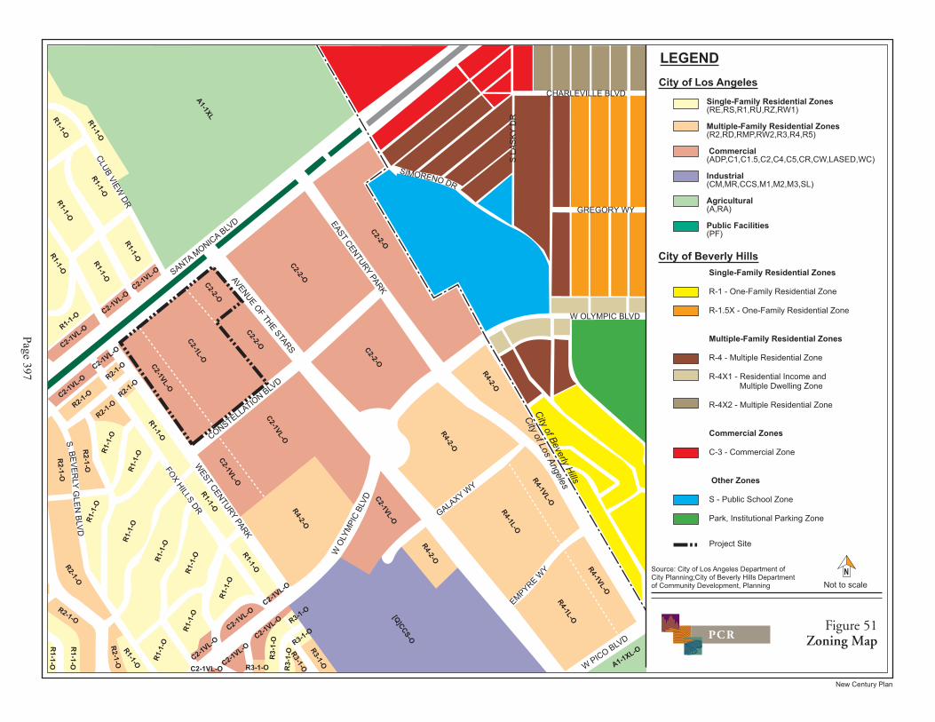
(2) Los Angeles Municipal Code (LAMC)
The City of Los Angeles Planning and Zoning Code (Chapter 1 of the LAMC) regulates development through land use designations and development standards. As shown in Figure 51 on page 397, the site encompasses three zoning designations as follows: C2-2-O along Avenue of the Stars (i.e., the 1801 Avenue of the Stars building); C2-1L-O extending from Santa Monica Boulevard to Constellation Boulevard through the center of the site (i.e., the majority of the existing shopping center); and C2-1VL-O along Century Park West (i.e., the western portion of the shopping center and the 1930 Century Park West building). The C2 portions of these designations indicate that the site is zoned for commercial uses (multi-family residential uses are also permitted within this zone). The second part of these zoning designations indicates the height districts that the site is located in. Three height districts apply to the project site: Height District No. 2 allows for unlimited building height and stories; Limited Height District No. 1 (1L) restricts building heights to a maximum of 75 feet and 6 stories; and Very Limited Height District No. 1 (1VL) restricts building heights to a maximum of 45 feet and three stories.144 Additionally, the third part of these zoning designations indicates that the project site is within a supplemental Oil Drilling District (O) as discussed below.
As detailed in LAMC Section 12.14.A, a wide range of commercial uses are permitted within the C2 zone, including various types of retail shops, grocery stores, restaurants and cafés, theaters, business and professional offices, entertainment uses, and parking facilities, as well as signage. High density multiple-family development is also permitted in the C2 zone, in compliance with the area, density, parking and related requirements of the R4 (Multiple Dwelling) zone. The sale and dispensing of alcoholic beverages is also permitted, pursuant to a Conditional Use Permit (CUP). In 1988, the City granted a CUP authorizing the sale and dispensing of alcoholic beverages for consumption on the shopping center premises, in conjunction with 18 restaurants, cafes, and delicatessens.145 To date, 15 of the 18 establishments have been utilized. In addition, the shopping center has a deemed-to-be approved CUP for off-site sales of alcohol for Gelson's Market.
Commercial uses within the C2 zone do not require front, side or rear yards, nor minimum lot areas. However, buildings or portions of buildings within the C2 zone that are used for residential purposes are subject to the side and rear yard requirements of the R4 zone, or a minimum side yard of five feet (in most instances) and minimum rear yard of 15 feet, as well as the R4 minimum lot area requirement of 5,000 square feet. Loading space requirements are specified in LAMC Section 12.21 C.6. 144 Section 12.21.2 of the City of Los Angeles Municipal Code. In addition, Section 7 of the CCNSP provides that
heights of structures which are located in the C2-1VL portion of the existing shopping center shall be measured from the plaza level.
145 City of Los Angeles Case No. CF 88-0469, approved May 6, 1988.
����������
����
���������������
����������������
�������������������
���
���
��
���
����������������
�����������
���������
���������
��������
���������� �
�������� �
�������������
����������
������������ ���������������
�������������� !���"�#��$�� �%&��
���'(������������ !���"�#��$�� �%&��
�������������� ���������������
��)����* $�+ ����"�#��$�� �%&��
��)�������"�#��$�� ���,&�����#�* $�+ �� -� ��.�%&��
��)�/����* $�+ ����"�#��$�� �%&��
�������������
�0���&���1,�� �%&��
������������
�����*2 �,��,3&& �%&��
��145���"$�$*$�&�� ���14��.�%&��
��
������
�
�'
��
��
���
���
��
�������������
����
�����������������
���
��
��
� �
������������ ���������������6��5��5��5��5�%5���7
�������������� ���������������6�/5� 5���5��/5�05�)5�(7
��������6� �5�5�'(5/5)5(5�5�5���� 5�7
���������6�5��5�5��5�/5�05��7
�����������6�5��7
����������������6��7
�����������������
�
!"!�#
�&$�$&�",� �
�&*1,�8��$!�&9��&"���.� �"� �+�1$���$�&9�$!�� �����.:�$!�&9��;�1 !��� "� �+�1$���$&9�&��*��$!� �;� &+���$5�� �����.
������$� ����������
������$�%�&�����'����
�1&<�,$���$�
��������
��-���$*1!�� ��
�(�() �*�*��
�*�( ��
�*�*��
�*�(+ ��
�*�(+ ��
�*�*���*�*��
�*�*��
�*�(+ ��
,�*��
�*�(+ ��
,�*��
,�*��
,�*��
,�( ��
,�( ��
,�(+ ��
,�(+ ��
-./�����
�(�()
��
0�(��
0�(��
�*�(+
���*�(+
��
�*�(+ ��
(�(��
0�(��
0�(��
�*�(+
��
�*�(+
��
0�(��
0�(��
�*�(+ ��
(�(��
(�(��
(�(��
(�(��
(�(��
(�(��
(�(��
(�(��
(�(��
(�(�� (�(��
(�(��
*�(��
*�(��
*�(��
*�(��
*�(��
(�(��
(�(��
�*�(+
��
*�(��
*�(��
(�(��
(�(��
(�(��
(�(��
(�(��
(�(��
(�(��
(�(��
�*�(+
��
�*�(+
���*�(+
��
�*�(+
��
*�(��
*�(��
0�(��

IV.G. Land Use
City of Los Angeles New Century Plan State Clearinghouse No. 2006061096 March 2008
Page 398
PRELIMINARY WORKING DRAFT – Work in Progress
As mentioned above, the project site is designated as being in a supplemental Oil Drilling District, defined in the Zoning Code as a district where oil drilling and/or production associated with oil or gas wells or other hydrocarbon substances is permitted. While the project site is located within the boundaries of the Beverly Hills Oil Field, no active or closed oil wells exist on-site. Given the history of oil production in the area, the project site is also located in a designated Methane Zone.146 Please see Section IV.E, Hazards and Hazardous Materials, for further discussion regarding this issue.
As shown in Figure 51, the properties surrounding the project site to the east and south are similarly zoned C2 (encompassing Height Districts 1, 1VL, and 2), allowing for the same range of uses and building heights/densities as the project site. The residential properties west of the site are zoned R1 (One-Family), R2 (Two-Family), and R3 (Multiple Dwelling), whereas the residential uses located within the Regional Center area of Century City (further south of the project site) are zoned R4. The commercial uses along Santa Monica Boulevard to the north of the project site are generally zoned C2. In addition, the Los Angeles Country Club north of the site is zoned A1 (Agriculture), corresponding to the open space use of the golf course. Further to the north is a single-family residential neighborhood in the R1 zone. As indicated previously, the jurisdictional boundary with the City of Beverly Hills is located a few blocks east of the project site. Immediately east of the City line, Beverly Hills High School is zoned S (Public School) zone, with R4 and R1.5 residential uses further to the east.
(3) Regional Plans and Applicable Policies
Regional land use plans that encompass the project area include the Southern California Association of Governments’ (SCAG) Regional Comprehensive Plan Guide (RCPG), which addresses regional development and forecasts growth for cities under its jurisdiction; and the Los Angeles County Congestion Management Plan (CMP), administered by the Metropolitan Transport Authority (MTA), which regulates regional traffic issues. In addition, the South Coast Air Quality Management District (SCAQMD) administers the Air Quality Management Plan (AQMP), which addresses attainment of State and federal ambient air quality standards throughout the South Coast Air Basin.
(a) SCAG Regional Comprehensive Plan and Guide, Regional Transportation Plan, and Growth Vision Report
SCAG is a joint powers agency with responsibilities pertaining to regional issues. SCAG’s responsibilities include preparation of the RCPG in conjunction with its constituent
146 Zoning information per Zone Information & Map Access System (ZIMAS), http://zimas.lacity.org, accessed
March 2007.

IV.G. Land Use
City of Los Angeles New Century Plan State Clearinghouse No. 2006061096 March 2008
Page 399
PRELIMINARY WORKING DRAFT – Work in Progress
members and other regional planning agencies. The RCPG is intended to serve as a framework for decision-making with respect to regional growth that is anticipated through the year 2015 and beyond, including growth management and regional mobility. In addition, the RCPG proposes a voluntary strategy for local governments to use in addressing issues related to future growth and in assessing the potential impacts of proposed development projects within the regional context. For planning purposes, the SCAG region has been divided into 14 subregions. The project site is located within the Los Angeles City subregion.
The RCPG includes five core chapters, Growth Management, Regional Mobility, Air Quality, Water Quality, and Hazardous Waste Management. Ancillary chapters within the RCPG including Economy, Housing, Human Resources and Services, Finance, Open Space and Conservation, Water Resources, Energy, and Integrated Waste Management, reflect other regional plans but do not contain actions or policies required of local governments. Adopted policies related to land use are contained primarily in the Growth Management chapter of the RCPG. The purpose of the Growth Management chapter is to present forecasts that establish the socio-economic parameters for the development of the Regional Mobility and Air Quality chapters of the RCPG and to address issues related to growth and land consumption. These parameters encourage local land use actions that could ultimately lead to the development of an urban form that will help minimize development costs, protect natural resources, and enhance the quality of life in the region. The Growth Management policies that relate to the proposed project are discussed in the analysis of impacts below.
DESTINATION 2030 is the 2004 Regional Transportation Plan (RTP) for the six-county region in southern California including Los Angeles, Orange, San Bernardino, Riverside, Ventura and Imperial. The RTP is a multi-modal Plan representing SCAG’s vision for a better transportation system, integrated with the best possible growth pattern for the region over the RTP horizon of 2030. The RTP provides the basic policy and program framework for long-term investment in the vast regional transportation system in a coordinated, cooperative and continuous manner. Transportation investments in the SCAG Region that receive State or federal transportation funds must be consistent with the RTP and must be included in the Regional Transportation Improvement Program (RTIP) when ready for funding. The RTP goals that relate to the proposed project are discussed in the analysis of impacts below.
In an effort to maintain the region’s prosperity, continue to expand its economy, house its residents affordably, and protect its environmental setting as a whole, SCAG has collaborated with interdependent sub-regions, counties, cities, communities and neighborhoods in a process referred to by SCAG as Southern California Compass, which resulted in the development of a shared Growth Vision for Imperial, Los Angeles, Orange, Riverside, San Bernardino and Ventura Counties. SCAG began Compass in 2002, spearheaded by the Growth Visioning Subcommittee, which consists of civic leaders from throughout the region. The shared regional
IV.G. Land Use
City of Los Angeles New Century Plan State Clearinghouse No. 2006061096 March 2008
Page 400
PRELIMINARY WORKING DRAFT – Work in Progress
vision sought to address issues such as congestion and housing availability, which may threaten the region’s livability.
The underlying goal of the growth visioning effort is to make the SCAG region a better place to live, work, and play for all residents regardless of race, ethnicity or income. To organize the strategies for improving the quality of life in the SCAG region, a series of principles was established by the Growth Vision Subcommittee. These goals are contained in the Growth Vision Report. The four principles are intended to promote and maximize regional mobility, livability, prosperity and sustainability. Decisions regarding growth, transportation, land use and economic development should support and be guided by these principles. Specific policy and planning strategies also are provided as a way to achieve each of the principles. The project’s consistency with the Growth Vision goals is discussed in the analysis of impacts below.
In addition, the Compass Blueprint 2% Strategy provides guidance for how and where SCAG can implement the Growth Vision for Southern California’s future. It calls for modest changes to current land use and transportation trends on only 2% of the land area of the region. As indicated on the 2% Strategy Opportunity Areas map for the City of Los Angeles – Central, the project site is not located within a Compass 2% Strategy Opportunity Area.
(b) SCAQMD Air Quality Management Plan (AQMP)
The SCAQMD was established in 1977 pursuant to the Lewis-Presley Air Quality Management Act. The SCAQMD is responsible for bringing air quality in the South Coast Air Basin (Basin) into conformity with federal and State air pollution standards. The SCAQMD is also responsible for monitoring ambient air pollution levels throughout the Basin and for developing and implementing attainment strategies to ensure that future emissions will be within federal and State standards. The SCAQMD’s AQMP, last amended in 2007, presents strategies for achieving the air quality planning goals set forth in the Federal and California Clean Air Acts (CAA), including a comprehensive list of pollution control measures aimed at reducing emissions. Further discussion of the AQMP can be found in Section IV.B, Air Quality, of this Draft EIR.
(c) MTA Congestion Management Program (CMP)
The Los Angeles County Metropolitan Transportation Authority administers the CMP, a State-mandated program designed to provide comprehensive long-range traffic planning on a regional basis. The CMP, revised in 2004, includes a hierarchy of highways and roadways with minimum level of service standards, transit standards, a trip reduction and travel demand management element, a program to analyze the impacts of local land use decisions on the regional transportation system, a seven-year capital improvement program, and a county-wide

IV.G. Land Use
City of Los Angeles New Century Plan State Clearinghouse No. 2006061096 March 2008
Page 401
PRELIMINARY WORKING DRAFT – Work in Progress
computer model used to evaluate traffic congestion and recommend relief strategies and actions. CMP guidelines specify that those freeway segments to which a project could add 150 or more trips in each direction during the peak hours be evaluated. The guidelines also require evaluation of designated CMP roadway intersections to which a project could add 50 or more trips during either peak hour. The CMP is discussed further in Section IV.J, Traffic and Circulation, of this Draft EIR.
3. ENVIRONMENTAL IMPACTS
a. Methodology
The analysis of potential land use impacts considers consistency of the project with adopted plans, policies, and ordinances that regulate land use on the project site, as well as the compatibility of proposed uses with surrounding land uses. The determination of consistency with applicable land use policies and ordinances is based upon a review of the previously identified planning documents that regulate land use or guide land use decisions pertaining to the project site. CEQA Guidelines Section 15125(d) requires that an EIR discuss inconsistencies with applicable plans that the decision-makers should address. Evaluations are made as to whether a project is inconsistent with such plans. Projects are considered consistent with General Plan provisions and general SCAG policies if they are compatible with the general intent of the plans and would not preclude the attainment of their primary goals.
The intent of the compatibility analysis is to determine whether the project would be compatible in relation to use, size, intensity, density, scale, and other physical and operational factors. The analysis is also intended to determine whether existing neighborhoods, communities, or land uses would be disrupted, divided, or isolated by the project and to consider the duration of any disruptions. The compatibility analysis is based on aerial photography, land use maps, and field surveys in which surrounding uses were identified and characterized. As such, the analysis addresses general land use relationships and urban form, based on a comparison of land use relationships in the project area under existing conditions at the time of the Notice of Preparation (NOP) to the conditions that would occur with project implementation.
b. Threshold of Significance
The following factors affecting a determination of potential significance will be applied to the proposed project and are set forth in the City of L.A. CEQA Thresholds Guide (2006) for consideration on a case-by-case basis:

IV.G. Land Use
City of Los Angeles New Century Plan State Clearinghouse No. 2006061096 March 2008
Page 402
PRELIMINARY WORKING DRAFT – Work in Progress
(1) Land Use Consistency
• Whether the proposal is inconsistent with the adopted land use/density designation in the Community Plan, redevelopment plan, or specific plan for the site; and
• Whether the proposal is inconsistent with the General Plan or adopted environmental goals or policies contained in other applicable plans.
Based on the factors presented above, the project would be considered to have a significant land use consistency impact if it was found to be in substantial conflict with either the adopted Community Plan, Specific Plans, or with the whole of relevant environmental policies in other applicable plans.
(2) Land Use Compatibility
• The extent of the area that would be impacted, the nature and degree of impacts, and the types of land uses within that area;
• The extent to which existing neighborhoods, communities, or land uses would be disrupted, divided, or isolated, and the duration of the disruptions; and
• The number, degree, and type of secondary impacts to surrounding land uses that could result from implementation of the proposed project.
Based on the factors presented above, the project would be considered to have a significant land use compatibility impact if it would substantially and adversely change the existing relationships between numerous land uses or properties in a neighborhood or community or have the long-term effect of adversely altering a neighborhood or community through ongoing disruption, division, or isolation.
c. Project Design Features
As described in detail in Section II., Project Description, as part of the project, existing buildings and outdoor areas within the northern, central, and eastern portions of the shopping center would be reconfigured or renovated to provide for new retail and restaurant spaces up to 75 feet in height above the plaza level (which is 7 to 11 feet above the adjacent street grade), as well as landscaping, open space amenities, new office uses, and parking areas. In addition, the project would replace the existing office building to the east of the existing shopping center at 1801 Avenue of the Stars with a residential development located above new shopping center uses and subterranean parking. This new building would have a maximum height of 579 feet above the plaza level of the shopping center (or 587 feet above grade). The existing office building at

IV.G. Land Use
City of Los Angeles New Century Plan State Clearinghouse No. 2006061096 March 2008
Page 403
PRELIMINARY WORKING DRAFT – Work in Progress
1930 Century Park West would be replaced with a new five-story parking facility (plus a rooftop parking level), with two existing subterranean parking levels below. As shown in Table 22 on page 404, when accounting for the existing commercial uses to be removed, the proposed project would result in a net increase of approximately 104,440 square feet of commercial uses as well as 262 luxury residential units.
As previously mentioned, the project would require a Specific Plan Amendment to the CCNSP to modify the definition of the Westfield Century City Shopping Center site to include the two adjacent properties, namely 1801 Avenue of the Stars and 1930 Century Park West. This amendment would identify the shopping center as a unified development site and facilitate proposed development of these three parcels as an integrated retail, entertainment, office, and residential development and ensure design and land use consistency. The Specific Plan Amendment would clarify that the heights of all buildings within the redefined shopping center site (including 1801 Avenue of the Stars and 1930 Century Park West) are measured from the plaza elevation, would allow floor area, density, and CATGP Trips to be shared within the site, and would clarify that the site is not subject to the City’s commercial corner ordinance. In addition, the CCNSP would be amended to acknowledge that there should be no limit on the number of stories within the shopping center’s Very Limited Height District No. 1 (1VL) (which would include 1930 Century Park West) so long as the 45 foot height limitation is not exceeded.
The Applicant also seeks a new CUP to replace the 1988 CUP approval, in order to clarify that the CUP would apply to the proposed expanded shopping center site.147 The Applicant seeks to increase the number of establishments serving alcohol relative to the 1988 approval from 18 allowable on-site establishments to 26. Additional project approvals include a Zoning Administrator Determination to allow shared use parking among the office, retail, restaurant, and theater uses in the shopping center portion of the site. A parking analysis for the project is provided in Section IV.J, Traffic and Circulation, of this Draft EIR, which supports approval of shared use parking. In addition, the project would be subject to Project Permit Compliance Review in accordance with the CCNSP, Site Plan Review and Major Project Review Findings. A Vesting Tentative Tract Map to subdivide the property is also proposed.
147 In 1988, the City granted a CUP authorizing the sale and dispensing of alcoholic beverages for consumption on
the shopping center premises, in conjunction with 18 restaurants, cafes, and delicatessens. In addition, the shopping center has a deemed-to-be approved CUP for off-site sales of alcohol for Gelson's Market and prior to 1988.

IV.G. Land Use
City of Los Angeles New Century Plan State Clearinghouse No. 2006061096 March 2008
Page 404
PRELIMINARY WORKING DRAFT – Work in Progress
d. Analysis of Project Impacts
(1) Consistency with Local Plans and Applicable Policies
As discussed above, project development would be subject to numerous local land use plans as well as applicable development standards set forth in the City’s Municipal Code. The project’s consistency with the requirements and policies of the Los Angeles General Plan Framework, Transportation Element of the General Plan, West Los Angeles Community Plan,
Table 22
Existing and Proposed Floor Area at Project Site a
Land Use Existing
Floor Area b Proposed Removal
Proposed New Floor Area
Net New Floor Area Total Floor Area
COMMERICAL USES 10250 Santa Monica Blvd
Retail/Restaurant 742,815 459,055 817,936 358,881 1,101,696 Cinema 90,578
[3,074 seats]c 0 – – 90,578
[3,074 seats] Office 0 0 106,523 106,523 106,523
1930 Century Park West
Office 62,246 62,246 0 (62,246) 0 1801 Avenue of the Stars
Retail 0 0 Included Above d Included Above d Included Above d Office 298,718 298,718 0 (298,718) 0
Total Commercial 1,194,357 820,019 924,459 104,440 1,298,797
RESIDENTIAL USES 1801 Avenue of the Stars Total Residential
0 0 945,000 e [up to 262 units]
945,000 e [up to 262 units]
945,000 e [up to 262 units]
a Floor area calculations refer to floor area as defined in the Century City North Specific Plan. All units are in square feet
unless otherwise indicated. b Existing floor area includes previously entitled floor area that was recently completed or is currently under construction at
the shopping center (including 63,075 net new square feet of shopping center uses plus replacement of 3,074 cinema seats within a new state-of-the-art facility).
c There are currently 3,074 seats within the cinema, which is less than the 3,085 seats that existed prior to the 2005 relocation of the cinema.
d The 1801 Avenue of the Stars retail floor area, which comprises approximately 194,300 square feet, is included in the 10250 Santa Monica Blvd (shopping center) retail floor area in order to provide clarity in the table with regard to the overall net new retail floor area that would result from implementation of the project..
e The residential square footage is approximate. Source: Westfield, LLC, 2007.

IV.G. Land Use
City of Los Angeles New Century Plan State Clearinghouse No. 2006061096 March 2008
Page 405
PRELIMINARY WORKING DRAFT – Work in Progress
Century City North Specific Plan, and LAMC is addressed below. Project consistency with the West Los Angeles Transportation Improvement and Mitigation Specific Plan is discussed in Section IV.J, Traffic and Circulation, of this Draft EIR.
(a) General Plan Framework
The project’s consistency with the General Plan Framework’s Land Use, Housing, Urban Form and Neighborhood Design, Open Space and Conservation, Economic Development, and Transportation Chapters is analyzed in Table 23 on page 406. As demonstrated therein, the project would be substantially consistent with the goals, objectives and policies of the General Plan Framework. To summarize, the project would be consistent with the site’s Regional Center designation in terms of land use, density and design, and based on its contribution to the existing diversity of uses in Century City by providing new retail, restaurant, entertainment, office, and residential uses, along with open air and pedestrian amenities. The project would also increase the vitality of the Century City area by enhancing the aesthetic appeal of the shopping center. The project site is well served by existing infrastructure, transit, and pedestrian amenities, and by promoting pedestrian activity, project development would facilitate a reduction of vehicle trips. The project would also help meet General Plan Framework housing goals by locating housing within a high activity area. Since the project would be consistent with the applicable goals and policies of the General Plan Framework, land use impacts relative to this plan would be less than significant.
(b) Transportation Element of the General Plan
The project would also be consistent with the Transportation Element Bicycle Plan. The project would not impede the use of Santa Monica Boulevard or Avenue of the Stars as Class II Bikeways. Almost all cyclists originate from residential areas since bike paths are used for commuting to a place of employment or school, or for recreational purposes. The project would support the Transportation Element Bikeway Plan, by locating residential uses within an urban center and in close proximity to existing non-motor transportation systems. As such, the impact of the project relative to the Bikeway Plan would be less than significant.
(c) West Los Angeles Community Plan
As discussed previously, the Community Plan designates the entire project site for Regional Commercial uses. Continued operation of the shopping center, including the proposed expansion of related shopping center uses and associated parking, would be consistent with this land use designation. In addition, as shown in Figure 48, various residential zones correspond to the Regional Commercial designation, thus the proposed residential uses would also be consistent with the site’s Community Plan designation. Relative to the general issues addressed

IV.G. Land Use
City of Los Angeles New Century Plan State Clearinghouse No. 2006061096 March 2008
Page 406
PRELIMINARY WORKING DRAFT – Work in Progress
Table 23
Consistency of Proposed Project with Applicable Policies of the General Plan Framework
Goal/Objective/Policy Analysis of Project Consistency
Land Use Chapter Objective 3.1: Accommodate a diversity of uses that support the needs of the City’s existing and future residents, businesses, and visitors.
Consistent. The project would accommodate a diversity of uses in Century City by providing new retail, restaurant, office, and residential uses, along with open air and pedestrian amenities. These new uses would serve the needs of the City’s existing and future residents and businesses.
Policy 3.1.1: Identify areas on the Land Use Diagram and the Community Plans sufficient for the development of a diversity of uses that serve the needs of existing and future residents (housing, employment, retail, entertainment, cultural/institutional, educational, health, services, recreation, and similar uses), provide job opportunities, and support visitors and tourism.
Consistent. Westfield Century City Shopping Center is identified as a Regional Center on the General Plan Framework’s Land Use Diagram. As discussed above, development of the proposed mix of uses would expand the land use diversity within this Regional Center and serve the needs of existing and future residents. The project would provide 262 new residential dwelling units and office space in immediate proximity to the expanded retail and restaurant uses within the shopping center. The project is expected to generate significant new economic activity in Los Angeles and enhance the shopping center's status as a premier retail, entertainment and economic center in Los Angeles. The project would also increase the vitality of the Century City area through enhancing the aesthetic appeal of the shopping center. Specifically, the project would renovate existing areas within the shopping center and provide for additional landscaping, open space amenities, and gathering places.
Policy 3.1.3: Identify areas for the establishment of new open space opportunities to serve the needs of existing and future residents. These opportunities may include a citywide linear network of parklands and trails, neighborhood parks, and urban open spaces.
Consistent. The project would include approximately 46,000 square feet of common open space and a private balcony within individual units for the proposed residential uses. The project would create new open spaces on the first level of the shopping center, as well as walkways and terraces above the first-level promenade. In addition, the project would provide a pedestrian network that would be consistent with that specified in the CCNSP.
Policy 3.1.4: Accommodate new development in accordance with land use and density provisions of the General Plan Framework Long-Range Land Use Diagram.
Consistent. The project would be consistent with the General Plan Framework Long-Range Land Use Diagram, which identifies the project site as a Regional Center targeted for high-density growth and economic development. The Framework also states that development of Regional Center sites integrating housing with commercial uses is encouraged in concert with supporting services, open space, and amenities. The proposed density is within the allowable density for the site, with approval of the requested CCNSP amendment to expand the definition of “shopping center” to include 1801 Avenue of the Stars and 1930 Century Park West, and treat all three properties as a unified site.
Policy 3.1.7: Allow for development in accordance with the policies, standards, and programs of specific plans in areas in which they have been adopted.
Consistent. The approximately 22-acre site is located within the CCNSP area. The properties comprising the project site are zoned C2-1VL-O, C2-1L-O, and C2-2-O. The surrounding properties located within the CCNSP are also zoned C2-2-O and C2-lVL-O, allowing for the same range of uses and building heights as the project site. Per LAMC Section 12.14, the C2 zoning designation allows for a variety of office, retail and

IV.G. Land Use
Table 23 (Continued)
Consistency of Proposed Project with Applicable Policies of the General Plan Framework
City of Los Angeles New Century Plan State Clearinghouse No. 2006061096 March 2008
Page 407
PRELIMINARY WORKING DRAFT – Work in Progress
Goal/Objective/Policy Analysis of Project Consistency residential uses. Specifically, residential uses within a C2 zone can occur pursuant to the provisions applicable to the R4 (multi-family) zone.
The project site includes three height designations including Height District 2, Height District 1L and Height District 1VL. Height District No. 2 allows for unlimited building height. The "1L" designation allows a maximum height of 75 feet and 6 stories and the "1VL" allows a maximum height of 45 feet and 3 stories. Under the CCNSP, the areas zoned C2-2-O and C2-1L-0 are in the Core Area and permitted a FAR of 6:1, and the area zoned C2-1VL-O is in the Buffer Area and permitted a FAR of 4.5:1. As analyzed below, project development would comply with these limitations with approval of the requested CCNSP amendment to treat the project as a unified site that can share density.
As addressed in the analysis below (refer specifically to Table 25 on page 423 the project would be consistent with the goals and objectives of the CCNSP. The project would serve to increase the vitality of the area through the integration of residential units in a multi-use Regional Center and revitalize the shopping center, by providing more open space, improved common areas, and new retail stores and restaurants.
The project site is also located within the boundaries of the West LA TIMP. Discussion of the West LA TIMP is provided in Section IV.J, Traffic and Circulation, of this Draft EIR.
Objective 3.2: To provide for the spatial distribution of development that promotes an improved quality of life by facilitating a reduction of vehicle trips, vehicle miles traveled, and air pollution.
Consistent. The project site is located within Century City, a high density area featuring a mix of land uses, including residential, retail, restaurants, entertainment, banking and other commercial offices and services. As discussed above, development of the proposed mix of uses would expand the land use diversity within the area and serve the needs of existing and future residents. The location of the proposed residential units within close proximity to places of employment, services, and other facilities would provide opportunities for the use of alternative modes of transportation. Alternative transportation modes within Century City include pedestrian paths, the Santa Monica Boulevard and the Avenue of the Stars components of the West Side Bicycle Plan, and dedicated bus lanes in the Santa Monica Transit Parkway. The convenient location of such services and the existing and proposed mix of uses would promote an improved quality of life by facilitating a reduction in vehicle trips and miles traveled.
Policy 3.2.2: Establish, through the Framework Long-Range Land Use Diagram, community plans, and other implementing tools, patterns and types of development that improve the integration of housing with commercial uses and the integration of public services and various densities of residential development within neighborhoods at
Consistent. Westfield Century City Shopping Center is identified as a Regional Center on the General Plan Framework’s Land Use Diagram. As discussed above, development of the proposed mix of uses would expand the land use diversity within this Regional Center and serve the needs of existing and future residents. The project would provide 262 new residential dwelling units and office space in immediate proximity to the expanded retail and restaurant uses within the shopping center. The project is expected to generate significant new economic

IV.G. Land Use
Table 23 (Continued)
Consistency of Proposed Project with Applicable Policies of the General Plan Framework
City of Los Angeles New Century Plan State Clearinghouse No. 2006061096 March 2008
Page 408
PRELIMINARY WORKING DRAFT – Work in Progress
Goal/Objective/Policy Analysis of Project Consistency appropriate locations. activity in Los Angeles and enhance the shopping center's status as a
premier retail, entertainment and economic center in Los Angeles. The project would also increase the vitality of the Century City area through enhancing the aesthetic appeal of the shopping center. Specifically, the project would renovate existing areas within the shopping center and provide for additional landscaping, open space amenities, and gathering places.
Policy 3.2.3: Provide for the development of land use patterns that emphasize pedestrian/bicycle access and use in appropriate locations.
Consistent. The design of the project would emphasize pedestrian connections, as addressed below in the analysis of project consistency with the CCNSP. The project would include a continuous pedestrian route throughout the shopping center and would connect to the existing pedestrian bridge over Avenue of the Stars to the east. The project would allow for improved pedestrian access to the stores, creating a more open shopping environment for patrons as well as providing new outdoor spaces to gather. The project also includes 262 new residential units adjacent to the shopping center, thus facilitating pedestrian access to local shopping, dining, and entertainment opportunities for project residents and visitors. Additionally, alternative modes of transportation within Century City that would be available to project residents would include the Santa Monica Boulevard and Avenue of the Stars components of the West Side Bicycle Plan and dedicated bus lanes in the Santa Monica Transit Parkway.
Policy 3.2.4: Provide for the siting and design of new development that maintains the prevailing scale and character of the City's stable residential neighborhoods and enhance the character of commercial and industrial districts.
Consistent. The project would enhance and improve the aesthetic appeal of and future commercial opportunities within the shopping center and surrounding area, while respecting the character of the neighboring community. The project would provide for expanded gathering places, new retail shops and restaurants which would increase economic activity in Century City and provide an attractive regional commercial center for future residents and visitors. The project would also be consistent with the density and height standards set forth by the CCNSP, with approval of the requested CCNSP amendment.
Additionally, the project would be consistent in terms of scale with existing uses. Retail building heights at the shopping center would continue to be substantially lower than most of the mid- to high-rise buildings on surrounding properties. Furthermore, the project’s design would utilize unique massing techniques to promote a feeling of openness. In addition, the height of the residential building would be comparable with other existing and approved high-rise buildings within the project vicinity.
The nearest single-family neighborhoods are located west of Century Park West, east of Century Park East (in the City of Beverly Hills), and to the northwest across Santa Monica Boulevard. The project would be buffered from all of these areas by intervening development and roadways. Given the distance of the proposed residential building from nearby single-family neighborhoods and the presence of numerous mid-
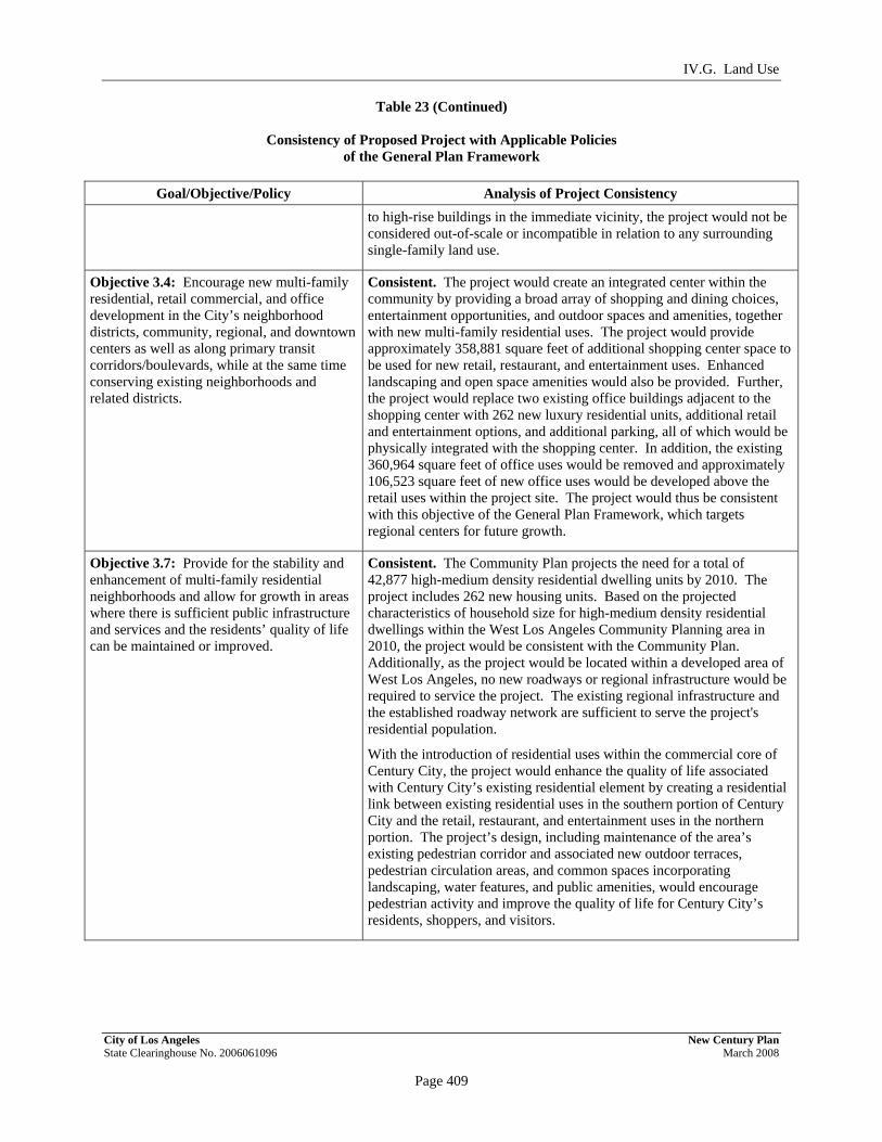
IV.G. Land Use
Table 23 (Continued)
Consistency of Proposed Project with Applicable Policies of the General Plan Framework
City of Los Angeles New Century Plan State Clearinghouse No. 2006061096 March 2008
Page 409
PRELIMINARY WORKING DRAFT – Work in Progress
Goal/Objective/Policy Analysis of Project Consistency to high-rise buildings in the immediate vicinity, the project would not be considered out-of-scale or incompatible in relation to any surrounding single-family land use.
Objective 3.4: Encourage new multi-family residential, retail commercial, and office development in the City’s neighborhood districts, community, regional, and downtown centers as well as along primary transit corridors/boulevards, while at the same time conserving existing neighborhoods and related districts.
Consistent. The project would create an integrated center within the community by providing a broad array of shopping and dining choices, entertainment opportunities, and outdoor spaces and amenities, together with new multi-family residential uses. The project would provide approximately 358,881 square feet of additional shopping center space to be used for new retail, restaurant, and entertainment uses. Enhanced landscaping and open space amenities would also be provided. Further, the project would replace two existing office buildings adjacent to the shopping center with 262 new luxury residential units, additional retail and entertainment options, and additional parking, all of which would be physically integrated with the shopping center. In addition, the existing 360,964 square feet of office uses would be removed and approximately 106,523 square feet of new office uses would be developed above the retail uses within the project site. The project would thus be consistent with this objective of the General Plan Framework, which targets regional centers for future growth.
Objective 3.7: Provide for the stability and enhancement of multi-family residential neighborhoods and allow for growth in areas where there is sufficient public infrastructure and services and the residents’ quality of life can be maintained or improved.
Consistent. The Community Plan projects the need for a total of 42,877 high-medium density residential dwelling units by 2010. The project includes 262 new housing units. Based on the projected characteristics of household size for high-medium density residential dwellings within the West Los Angeles Community Planning area in 2010, the project would be consistent with the Community Plan. Additionally, as the project would be located within a developed area of West Los Angeles, no new roadways or regional infrastructure would be required to service the project. The existing regional infrastructure and the established roadway network are sufficient to serve the project's residential population.
With the introduction of residential uses within the commercial core of Century City, the project would enhance the quality of life associated with Century City’s existing residential element by creating a residential link between existing residential uses in the southern portion of Century City and the retail, restaurant, and entertainment uses in the northern portion. The project’s design, including maintenance of the area’s existing pedestrian corridor and associated new outdoor terraces, pedestrian circulation areas, and common spaces incorporating landscaping, water features, and public amenities, would encourage pedestrian activity and improve the quality of life for Century City’s residents, shoppers, and visitors.

IV.G. Land Use
Table 23 (Continued)
Consistency of Proposed Project with Applicable Policies of the General Plan Framework
City of Los Angeles New Century Plan State Clearinghouse No. 2006061096 March 2008
Page 410
PRELIMINARY WORKING DRAFT – Work in Progress
Goal/Objective/Policy Analysis of Project Consistency Policy 3.8.3: Encourage the owners of existing commercial shopping centers that contain chain grocery and drug stores to include additional uses, such as restaurants, entertainment, childcare facilities, public meeting rooms, recreation, cultural facilities, and public open spaces, which enhance neighborhood activity.
Consistent. Although this policy applies specifically to Neighborhood Districts, and the project site is located within a designated Regional Center, the project consists of an existing shopping center that presently contains a grocery store serving the local residential community. Included within the shopping center and proposed as part of the project are a variety of retail uses, restaurant uses, and pedestrian amenities, including outdoor plazas, gathering spaces, landscaping, and water features. In addition, recent improvements to the shopping center included a Family Lounge which provides play facilities, nursing stations, and baby changing stations.
Goal 3F: Mixed use centers that provide jobs, entertainment, culture, and serve the region.
Consistent. The project would provide space for new retail, restaurant and office uses within the shopping center and surrounding area, thereby facilitating new job opportunities in the Century City Regional Center. The project also provides for renovation and expansion of the current retail facilities available within the shopping center that would foster job creation in the area.
Objective 3.10: Reinforce existing, and encourage development of new, regional centers that accommodate a broad range of uses that serve, provide job opportunities, and are accessible to the region, are compatible with adjacent land uses, and are developed to enhance urban lifestyles.
Consistent. The project reinforces the Century City Regional Center by providing new commercial and residential uses. The project would improve retail options at the shopping center, which is an existing center of commercial and entertainment activity in Century City. As discussed throughout this section, the project would be compatible with adjacent uses. The project is bounded on the north by commercial and multi-family uses and the Los Angeles Country Club. High-rise office buildings, hotels and parking structures, including the 36-story MGM building and 19-story Century Plaza Hotel, are located to the south of the site. The project is bounded on the west by single-family residential uses, located across Century Park West. Mid-rise and high-rise office buildings, including the 39-story SunAmerica building, are located to the east of the project site. Residents and visitors of the project would have easy access to all of the adjacent business, employment, entertainment, and lodging uses, as well as those within the shopping center itself. The project would also incorporate an architectural design that complements the existing character of the shopping center and surrounding area.
Goal 3L: Districts that promote pedestrian activity and provide a quality experience for the City’s residents.
Consistent. The proposed project would enhance pedestrian activity within the project site through the provision of new outdoor promenades and plazas that would connect with the existing pedestrian paths within the vicinity including the pedestrian paths specified by the CCNSP. In addition, the project would enhance landscaping in the area, particularly along Santa Monica Boulevard as well as provide a quality environment to live, work and entertain.
Objective 3.16: Accommodate land uses, locate and design buildings, and implement streetscape amenities that enhance pedestrian activity.
Consistent. The project proposes open space areas within the shopping center and new residential development. As discussed above, the project’s design, including maintenance of the area’s existing pedestrian corridor and associated new outdoor terraces, gathering spaces,

IV.G. Land Use
Table 23 (Continued)
Consistency of Proposed Project with Applicable Policies of the General Plan Framework
City of Los Angeles New Century Plan State Clearinghouse No. 2006061096 March 2008
Page 411
PRELIMINARY WORKING DRAFT – Work in Progress
Goal/Objective/Policy Analysis of Project Consistency pedestrian circulation areas, and common spaces incorporating landscaping, water features, and public amenities, would encourage pedestrian activity.
Housing Chapter Policy 4.1.1: Provide sufficient land use and density to accommodate an adequate supply of housing units by type and cost within each City sub-region to meet the twenty-year projections of housing needs.
Consistent. The project includes 262 residential units, in addition to new retail and restaurant uses, office space, and related amenities. As discussed throughout this analysis, this mix of uses and the proposed density is fully consistent with the zoning, General Plan, and Specific Plan designations for the property.
The 2010 projected population increase in the West Los Angeles sub-region is approximately 10,509 new residents, of which approximately 62 percent (6,516 persons) are expected to reside in multi-family units. Approximately 6,806 new high-medium density residential units, in addition to other housing, are needed to meet the 2010 projected population. The project would contribute to the multi-family housing goals for the West Los Angeles area by providing approximately 4.2 percent of the projected high-medium density residential development.
Objective 4.2: Encourage the location of new multi-family housing development to occur in proximity to transit stations, along some transit corridors, and within some high activity areas with adequate transitions and buffers between higher density development and surrounding lower density residential neighborhoods.
Consistent. The project will situate 262 housing units within an area that is well served by existing transit facilities. The project site is adjacent to the Santa Monica Boulevard transit corridor and within close proximity to three major roadways, including Avenue of the Stars, Santa Monica Boulevard, and Olympic Boulevard, as well as a new transit plaza located on Constellation Boulevard. Century City is a high activity center with adequate transitions and buffers between it and the surrounding lower density residential neighborhoods. The proposed high-density multi-family development would be buffered from lower density residential areas by existing intervening uses and Century Park West. Specifically, the proposed multi-family residential uses would be located within the northeastern portion of the site with intervening shopping center buildings located between the new higher density residential uses and the low-density residential uses to the west of Century Park West In addition, the location of high-density housing in a commercial area increases housing within the community while preserving the lower density residential neighborhoods.
Urban Form and Neighborhood Design Chapter Goal 5A: A livable City for existing and future residents and one that is attractive to future investment. A City of interconnected, diverse neighborhoods that builds on the strengths of those neighborhoods and functions at both the neighborhood and Citywide scales.
Consistent. The project represents an investment in high quality commercial development and urban housing. By locating multi-family residential units in close proximity to jobs, transit, shops and restaurants, the project will enhance the quality of life for residents, workers and visitors to the area. The Century City area is characterized by a range of housing types, including single-family, mid-size and high-rise apartments and condominiums, and large-scale commercial development. The project would be consistent with these uses. Additionally, development of new retail stores and common areas within the shopping center would

IV.G. Land Use
Table 23 (Continued)
Consistency of Proposed Project with Applicable Policies of the General Plan Framework
City of Los Angeles New Century Plan State Clearinghouse No. 2006061096 March 2008
Page 412
PRELIMINARY WORKING DRAFT – Work in Progress
Goal/Objective/Policy Analysis of Project Consistency increase attractive shopping and entertainment options for the community and provide an important opportunity for continued investment in the Century City Regional Center and surrounding area.
Objective 5.2: Encourage future development in centers and in nodes along corridors that are served by transit and are already functioning as centers for the surrounding neighborhoods, the community, or the region.
Consistent. Century City is designated as a Regional Center, containing high-rise buildings, mid-rise and high-rise apartments and condominiums, and large-scale commercial development. Century City’s businesses, hotel, entertainment, restaurants, and retail services are a regional draw to the surrounding community and broader area. Century City is also adjacent to major arterials and the Santa Monica Transit Parkway, which provide public and non-motorized transportation options and regional linkage. The project proposes to develop areas already designated as centers of residential and commercial activity in Century City and enhance those areas as an integrated center of activity for Century City and West Los Angeles.
Policy 5.2.1: Designate centers and districts in locations where activity is already concentrated and/or where good transit service is, or will be provided.
Consistent. The project is located in Century City, which is designated and currently functions as a Regional Center. Public transit is provided along various major arterials serving Century City, as well as throughout the internal street circulation system. The project site is located within a high-density, high-rise center and is surrounded by office and commercial buildings in a dense urban landscape. The project further develops the Westfield Century City Shopping Center, which is a regional shopping center containing various department stores, a food market, and numerous retail and entertainment uses.
Policy 5.2.2: Encourage the development of centers, districts, and selected corridor/boulevard nodes such that the land uses, scale, and built form allowed and/or encouraged within these areas allow them to function as centers and support transit use, both in daytime and nighttime.
Consistent. As discussed throughout this analysis, the project would be consistent with the existing uses, scale, and built form of Century City and would support the designation of this area as a Regional Center. The project would also provide a new residential base to support the existing retail, restaurant, entertainment, and office uses within the Regional Center. With a greater balance of office and residential uses within the locale, daytime and nighttime activity would be enhanced. Additionally, the integration of 262 new residential units with the shopping center would reduce vehicle trips for new residents and encourage pedestrian activity related to shopping and entertainment. The project incorporates several pedestrian-oriented design elements, including open air and common areas within the shopping center, thereby encouraging pedestrian activity and enhancing pedestrian access.
Objective 5.8: Reinforce or encourage the establishment of a strong pedestrian orientation in designated neighborhood districts, community centers, and pedestrian-oriented subareas within regional centers, so that these districts and centers can serve as a focus of activity for the surrounding community and a focus for investment in the community.
Consistent. The project includes the expansion of open air areas and walkways in the shopping center, thereby reinforcing its current pedestrian orientation. More specifically, the project would maintain the area’s existing pedestrian corridor, connect to the existing pedestrian bridge across Avenue of the Stars, and introduce new outdoor terraces, pedestrian circulation areas, and common spaces incorporating landscaping, water features, and public amenities, all of which would encourage pedestrian activity. The project would create an integrated center within the community by providing a broad array of shopping and dining choices, entertainment opportunities, and outdoor spaces and

IV.G. Land Use
Table 23 (Continued)
Consistency of Proposed Project with Applicable Policies of the General Plan Framework
City of Los Angeles New Century Plan State Clearinghouse No. 2006061096 March 2008
Page 413
PRELIMINARY WORKING DRAFT – Work in Progress
Goal/Objective/Policy Analysis of Project Consistency amenities, thus enhancing continued investment opportunities in both the shopping center and Century City.
Objective 5.9: Encourage proper design and effective use of the built environment to help increase personal safety at all times of the day.
Consistent. The project has been designed such that outdoor gathering and recreation areas within the project site are visible by project residents, visitors and/or employees. In addition, the residential areas of the site would be secured during nighttime hours and 24-hour security would be provided at the site.
Open Space and Conservation Chapter Policy 6.4.8: Maximize the use of existing public open space resources at the neighborhood scale and seek new opportunities for private development to enhance the open space resources of the neighborhoods.
a. Encourage the development of public plazas, forested streets, farmers markets, residential commons, rooftop spaces, and other places that function like open space in urbanized areas of the City with deficiencies of natural open space, especially in targeted growth areas.
Consistent. Century City is a designated Regional Center that is a targeted growth area. The project would include open space area within the residential development and shopping center, including additional common areas and pedestrian connections throughout the shopping center. The residential component of the project would comply with the open space requirements of the Zoning Code. Specifically, residential amenities would be provided, including on-site recreational facilities and other features such as rooftop gardens.
Economic Development Goal 7B: A City with land appropriately and sufficiently designated to sustain a robust commercial and industrial base.
Consistent. The project would expand and revitalize Westfield Century City Shopping Center, thereby facilitating further diversification of retail and entertainment options and providing an attractive market for new investment opportunities within Century City.
Objective 7.2: Establish a balance of land uses that provides for commercial and industrial development which meets the needs of local residents, sustains economic growth, and assures maximum feasible environmental quality.
Consistent. The project would provide for the simultaneous development of 262 residential units adjacent to the shopping center and expansion of the shopping center to make it more attractive as a center for economic activity. This development is necessary to sustain the economic growth of the shopping center as a regional center and to meet the shopping and entertainment needs of residents and visitors of Century City.
Policy 7.2.2: Concentrate commercial development entitlements in areas best able to support them, including community and regional centers, transit stations, and mixed use corridors. This concentration prevents commercial development from encroaching on existing residential neighborhoods.
Consistent. Century City is currently designated as a Regional Center. The project would expand commercial activities at Westfield Century City Shopping Center, consistent with the Framework's goals. Furthermore, with development of associated residential and office uses, the resulting integrated center would build on the mixed use nature of Century City as a whole.
Policy 7.2.3: Encourage new commercial development in proximity to rail and bus transit corridors and stations.
Consistent. The project is located on Santa Monica Boulevard, a major route with several public bus line stops. The project is also located in close proximity to several other transit options.

IV.G. Land Use
Table 23 (Continued)
Consistency of Proposed Project with Applicable Policies of the General Plan Framework
City of Los Angeles New Century Plan State Clearinghouse No. 2006061096 March 2008
Page 414
PRELIMINARY WORKING DRAFT – Work in Progress
Goal/Objective/Policy Analysis of Project Consistency Objective 7.3: Maintain and enhance the existing businesses in the City.
Consistent. The project would provide new and diverse amenities and retail stores at the shopping center. These improvements would ensure the future vitality of the shopping center and improve Century City as a walkable community by providing options to live and play in an area that is already a mature employment hub. Further, the project would provide for the development of 262 new residential units adjacent to the shopping center. This is expected to provide increased revenue and sales for the shopping center and surrounding areas.
Policy 7.3.2: Retain existing neighborhood commercial activities within walking distance of residential areas.
Consistent. The project includes the development of 262 new residential units within walking distance of the shopping center and existing and proposed office uses. The project would also expand retail uses that would be within walking distance of residential areas.
Policy 7.8.3: Encourage mixed-use development projects, which include revenue generating retail, to offset the fiscal costs associated with residential development.
Consistent. The project would provide approximately 358,881 square feet of additional shopping center space, 262 new luxury residential units, and approximately 106,523 square feet of new office uses. Thus, the project would generate revenue from retail uses to offset the costs associated with residential development.
Objective 7.9: Ensure that the available range of housing opportunities is sufficient, in terms of location, concentration, type, size, price/rent range, access to local services and access to transportation, to accommodate future population growth and to enable a reasonable portion of the City's work force to both live and work in the City.
Consistent. The project would provide a mix of unit types and would increase needed available housing in an area with an established employment base. The project is located on Santa Monica Boulevard, a major route with several public bus line stops. The availability of transit service along with the range of unit types would accommodate future population growth and enable a reasonable portion of the City's work force to both live and work in the City.
Transportation Objective 3: Support development in regional centers, community centers, major economic activity areas and along mixed use boulevards as designated in the Community Plans.
Consistent. The project is located in Century City, which is designated and currently functions as a Regional Center. Public transit is provided along various major arterials serving Century City, as well as throughout the internal street circulation system. The project would expand commercial development at Westfield Century City Shopping Center and enhance it as a center for community activity. Simultaneously, the project will locate multi-family residential units in close proximity to jobs, transit, shops and restaurants located in the shopping center and throughout the immediate area.
Objective 4: Preserve the existing character of lower density residential areas and maintain pedestrian-oriented environments where appropriate.
Consistent. Consistent with this goal, the project would locate higher density development within an established Regional Center, thus preserving the surrounding lower-density residential areas. In addition, the project will provide 262 residential units and associated amenities with new pedestrian amenities and gathering places, thereby enhancing the pedestrian-oriented nature of the shopping center and facilitating easier pedestrian access to it.
Source: PCR Services Corporation, 2007.

IV.G. Land Use
City of Los Angeles New Century Plan State Clearinghouse No. 2006061096 March 2008
Page 415
PRELIMINARY WORKING DRAFT – Work in Progress
in the Community Plan, Westfield Century City Shopping Center would continue to operate within the existing shopping center and adjacent commercial properties and thus would not physically divide or interfere with the surrounding residential community. While the project would introduce new residential uses within the commercial core of Century City, the establishment of mixed use development would support various Community Plan goals. In general, the existing land use relationships in the area as well as the overall character of the neighborhood would be preserved. As discussed below and in further detail in Section IV.A, Aesthetics/Visual Resources, the design of the proposed improvements would enhance the visual character of the shopping center, be aesthetically compatible with existing uses on-site, introduce additional pedestrian-scaled commercial development, and generally improve the identity of the area and the Santa Monica Boulevard commercial corridor. Furthermore, the project would not result in significant land use compatibility impacts. For example, relative to residential issues, the shopping center would continue to serve as a buffer or transition between the single-family residential neighborhood to the west and the project’s proposed high-rise development along Avenue of the Stars, as discussed further below. Additionally, as discussed in relevant analyses throughout Section IV, Environmental Impact Analysis, of this Draft EIR, project implementation would not significantly affect the capacity of public infrastructure serving the site and surrounding area.
Table 24 on page 416 provides an analysis of the project’s consistency with applicable land use goals, objectives, and policies of the West Los Angeles Community Plan. As indicated therein, the project would be substantially consistent with the Community Plan. The project would also support Community Plan policies pertaining to related issues, such as transportation, in that it would comply with applicable provisions of the Century City North Specific Plan and the West Los Angeles Transportation Improvement and Mitigation Specific Plan (both analyzed below) and implement necessary parking, access, and intersection improvements. Based on the analysis, the project would not conflict with the land use provisions of the Community Plan. As such, the project’s impact relative to the Community Plan would be less than significant. The relationship of the project to the Community Plan Urban Design policies (Community Plan Chapter V) is discussed in Section IV.A, Aesthetics/Visual Resources, of this Draft EIR.
(d) Century City North Specific Plan
As described above, the CCNSP establishes a two-part development phasing strategy to assure orderly development and provide adequate infrastructure with build-out of the existing zoning for the area. Pursuant to City of Los Angeles Case No. CF 98-0672, all Phase I improvements have been completed and the CCNSP is now acting in its second phase. In accordance with the second phase of the CCNSP, the project would be required to obtain a Project Permit, for which specific findings must be made by the City Planning Commission (discussed below).
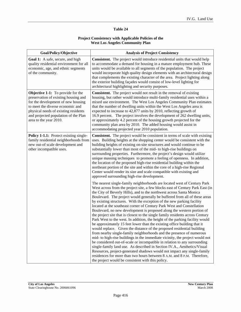
IV.G. Land Use
City of Los Angeles New Century Plan State Clearinghouse No. 2006061096 March 2008
Page 416
PRELIMINARY WORKING DRAFT – Work in Progress
Table 24
Project Consistency with Applicable Policies of the West Los Angeles Community Plan
Goal/Policy/Objective Analysis of Project Consistency
Goal 1: A safe, secure, and high quality residential environment for all economic, age, and ethnic segments of the community.
Consistent. The project would introduce residential units that would help to accommodate a demand for housing in a mature employment hub. These units would be available to all segments of the population. The project would incorporate high quality design elements with an architectural design that complements the existing character of the area. Project lighting along the exterior building façades would consist of low-level lighting for architectural highlighting and security purposes.
Objective 1-1: To provide for the preservation of existing housing and for the development of new housing to meet the diverse economic and physical needs of existing residents and projected population of the Plan area to the year 2010.
Consistent. The project would not result in the removal of existing housing, but rather would introduce multi-family residential uses within a mixed use environment. The West Los Angeles Community Plan estimates that the number of dwelling units within the West Los Angeles area is expected to increase to 42,877 units by 2010, reflecting growth of 16.9 percent. The project involves the development of 262 dwelling units, or approximately 4.2 percent of the housing growth projected for the community plan area by 2010. The added housing would assist in accommodating projected year 2010 population.
Policy 1-1.1: Protect existing single-family residential neighborhoods from new out-of scale development and other incompatible uses.
Consistent. The project would be consistent in terms of scale with existing uses. Building heights at the shopping center would be consistent with the building heights of existing on-site structures and would continue to be substantially lower than most of the mid- to high-rise buildings on surrounding properties. Furthermore, the project’s design would utilize unique massing techniques to promote a feeling of openness. In addition, the location of the proposed high-rise residential building within the northeast portion of the site and within the core of a high-rise Regional Center would render its size and scale compatible with existing and approved surrounding high-rise development.
The nearest single-family neighborhoods are located west of Century Park West across from the project site, a few blocks east of Century Park East (in the City of Beverly Hills), and to the northwest across Santa Monica Boulevard. The project would generally be buffered from all of these areas by existing structures. With the exception of the new parking facility located at the southeast corner of Century Park West and Constellation Boulevard, no new development is proposed along the western portion of the project site that is closest to the single family residents across Century Park West to the west. In addition, the height of the parking facility would be approximately 15 feet lower than the existing office building that it would replace. Given the distance of the proposed residential building from nearby single-family neighborhoods and the presence of numerous mid- to high-rise buildings in the immediate vicinity, the project would not be considered out-of-scale or incompatible in relation to any surrounding single-family land use. As described in Section IV.A., Aesthetics/Visual Resources, project-generated shadows would not impact any single-family residences for more than two hours between 8 A.M. and 8 P.M. Therefore, the project would be consistent with this policy.
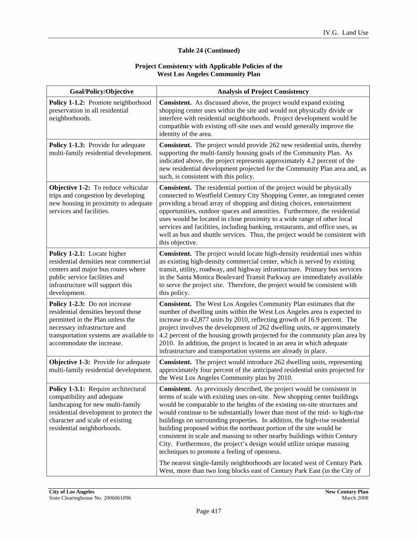
IV.G. Land Use
Table 24 (Continued)
Project Consistency with Applicable Policies of the West Los Angeles Community Plan
City of Los Angeles New Century Plan State Clearinghouse No. 2006061096 March 2008
Page 417
PRELIMINARY WORKING DRAFT – Work in Progress
Goal/Policy/Objective Analysis of Project Consistency Policy 1-1.2: Promote neighborhood preservation in all residential neighborhoods.
Consistent. As discussed above, the project would expand existing shopping center uses within the site and would not physically divide or interfere with residential neighborhoods. Project development would be compatible with existing off-site uses and would generally improve the identity of the area.
Policy 1-1.3: Provide for adequate multi-family residential development.
Consistent. The project would provide 262 new residential units, thereby supporting the multi-family housing goals of the Community Plan. As indicated above, the project represents approximately 4.2 percent of the new residential development projected for the Community Plan area and, as such, is consistent with this policy.
Objective 1-2: To reduce vehicular trips and congestion by developing new housing in proximity to adequate services and facilities.
Consistent. The residential portion of the project would be physically connected to Westfield Century City Shopping Center, an integrated center providing a broad array of shopping and dining choices, entertainment opportunities, outdoor spaces and amenities. Furthermore, the residential uses would be located in close proximity to a wide range of other local services and facilities, including banking, restaurants, and office uses, as well as bus and shuttle services. Thus, the project would be consistent with this objective.
Policy 1-2.1: Locate higher residential densities near commercial centers and major bus routes where public service facilities and infrastructure will support this development.
Consistent. The project would locate high-density residential uses within an existing high-density commercial center, which is served by existing transit, utility, roadway, and highway infrastructure. Primary bus services in the Santa Monica Boulevard Transit Parkway are immediately available to serve the project site. Therefore, the project would be consistent with this policy.
Policy 1-2.3: Do not increase residential densities beyond those permitted in the Plan unless the necessary infrastructure and transportation systems are available to accommodate the increase.
Consistent. The West Los Angeles Community Plan estimates that the number of dwelling units within the West Los Angeles area is expected to increase to 42,877 units by 2010, reflecting growth of 16.9 percent. The project involves the development of 262 dwelling units, or approximately 4.2 percent of the housing growth projected for the community plan area by 2010. In addition, the project is located in an area in which adequate infrastructure and transportation systems are already in place.
Objective 1-3: Provide for adequate multi-family residential development.
Consistent. The project would introduce 262 dwelling units, representing approximately four percent of the anticipated residential units projected for the West Los Angeles Community plan by 2010.
Policy 1-3.1: Require architectural compatibility and adequate landscaping for new multi-family residential development to protect the character and scale of existing residential neighborhoods.
Consistent. As previously described, the project would be consistent in terms of scale with existing uses on-site. New shopping center buildings would be comparable to the heights of the existing on-site structures and would continue to be substantially lower than most of the mid- to high-rise buildings on surrounding properties. In addition, the high-rise residential building proposed within the northeast portion of the site would be consistent in scale and massing to other nearby buildings within Century City. Furthermore, the project’s design would utilize unique massing techniques to promote a feeling of openness.
The nearest single-family neighborhoods are located west of Century Park West, more than two long blocks east of Century Park East (in the City of

IV.G. Land Use
Table 24 (Continued)
Project Consistency with Applicable Policies of the West Los Angeles Community Plan
City of Los Angeles New Century Plan State Clearinghouse No. 2006061096 March 2008
Page 418
PRELIMINARY WORKING DRAFT – Work in Progress
Goal/Policy/Objective Analysis of Project Consistency Beverly Hills), and to the northwest across Santa Monica Boulevard behind the existing commercial and multi-family uses. Given the distance of the proposed residential building from nearby single-family neighborhoods and the presence of numerous mid- to high-rise buildings in the immediate vicinity, the project would not be considered out-of-scale or incompatible in relation to any surrounding single-family land use. Furthermore, a landscaping plan that would complement and enhance the existing character of the project site would also be implemented as part of the project, and any street trees removed during construction would be replaced in accordance with City requirements.
Objective 1-4: To promote adequate and affordable housing and increase its accessibility to more segments of the population, especially students and senior citizens.
Partially Consistent. The project would increase the available housing supply and would provide a range of housing types. However, the project would not provide affordable residential units. Thus, the project would not be consistent with this policy.
Policy 1-4.1: Promote greater individual choice in type, quality, price and location of housing.
Consistent. The project would provide high-density residential uses in a high-density commercial area of the City. These luxury residential units would accommodate demand for housing in a mature employment hub and offer a new type of housing in the area. The location of multiple-family housing in the Century City commercial core would provide easy access for residents to services and public transportation, thus taking advantage of the mixed use nature of the area.
Policy 1-4.2: Ensure that new housing opportunities minimize displacement of residents.
Consistent. As previously discussed, no existing housing or associated residents would be displaced by the project.
Policy 1-4.3: Encourage multiple-family residential development in specified commercial zones.
Consistent. The project would be constructed in a commercially-designated area that allows multi-family residential uses. The project would thus capitalize on the synergistic effects of an integrated center providing residential uses as well as a broad array of shopping and dining choices, entertainment opportunities, outdoor spaces and amenities.
Goal 2: A strong and competitive commercial sector which promotes economic vitality, serves the needs of the community through well designed, safe and accessible areas while preserving historic and cultural character.
Partially Consistent. The proposed improvements would ensure the future vitality of the shopping center and enhance Century City as a walkable community by providing options to live, play, and shop in an area that is already a mature employment hub. As discussed above, the project would capitalize on the synergistic effects of an integrated center that provides residential uses as well as a broad array of shopping and dining choices, entertainment opportunities, outdoor spaces and amenities. The project would incorporate low-level exterior lighting for security purposes and would include pedestrian pathways and parking areas that would be convenient and safe, consistent with this policy. The project would result in the removal of the building located at 1801 Avenue of the Stars. As discussed in Section IV.C, Historic Resources, the building is representative of a design type that is characteristic of a particular period in state architectural history, and the building is also the product of an important creative individual’s firm, Welton Becket and Associates. However, the building is not a widely recognized or noteworthy example

IV.G. Land Use
Table 24 (Continued)
Project Consistency with Applicable Policies of the West Los Angeles Community Plan
City of Los Angeles New Century Plan State Clearinghouse No. 2006061096 March 2008
Page 419
PRELIMINARY WORKING DRAFT – Work in Progress
Goal/Policy/Objective Analysis of Project Consistency within the Becket firm’s body of work, cannot be directly associated with Welton Becket, himself, and has outlasted the context in Century City for which it was designed and built. Notwithstanding the foregoing points of detraction, however, the building and its associated contributing features and objects are, for purposes of conservative assessment, considered potentially eligible for the California Register under Criterion 3 and potential eligibility as a City of Los Angeles Historic-Cultural Monument. Thus, the project would not be fully consistent with this goal.
Objective 2-1: To conserve and strengthen viable commercial development and to provide additional opportunities for new commercial development and services within existing commercial areas.
Consistent. As discussed, the proposed improvements would ensure the future vitality of the shopping center and enhance Century City as a walkable community by providing options to live, play, and shop in an area that is already a mature employment hub. The project would represent an expansion of commercial uses, including retail and new office uses on-site, within an existing commercial site.
Policy 2-1.1: New commercial uses shall be located in existing established commercial areas or shopping centers.
Consistent. The project would represent an expansion of commercial uses within an existing shopping center located within an established commercial area.
Policy 2-1.2: Protect commercially planned/zoned areas from encroachment by residential only development.
Consistent. While the project would introduce residential uses within a commercially-zoned property, the project would be a mixed use development also providing commercial, retail, and office uses. This integrated center would build on the mixed-use nature of Century City as a whole.
Objective 2-2: To promote distinctive commercial districts and pedestrian-oriented areas.
Consistent. Century City is a distinctive commercial district featuring high-rise architecture; a mix of uses and services; a residential component; and pedestrian linkages and paths. Existing zoning and plans within Century City permit development with a FAR of up to 6:1 in most places. The project would promote the distinct character of Century City by developing high-quality structures that would comply with these FAR regulations, with approval of the requested CCNSP amendment to treat the project as a unified site. Specifically, the proposed commercial improvements would enhance the existing shopping center, and the proposed residential element would introduce a high-rise building within the high-density commercial core of the area. The project would maintain a continuous pedestrian walkway throughout the shopping center and would connect to the existing pedestrian bridge to the east across Avenue of the Stars. The project would also incorporate pedestrian amenities, including outdoor plazas, landscaping, and water features within the shopping center, in keeping with the pedestrian environment of Century City. Therefore, the project would be consistent with this policy by enhancing Century City’s distinctive land use pattern, architecture, and pedestrian amenities.
Policy 2-2.1: Encourage pedestrian-oriented design in designated areas and in new development.
Consistent. As discussed above, the project would maintain a continuous pedestrian walkway throughout the shopping center and would connect to the existing Avenue of the Stars pedestrian bridge. The improvements would be designed to promote a feeling of openness, with outdoor terraces, pedestrian circulation areas, and common spaces incorporating landscaping, water features, and public amenities. Pedestrian access to the shopping
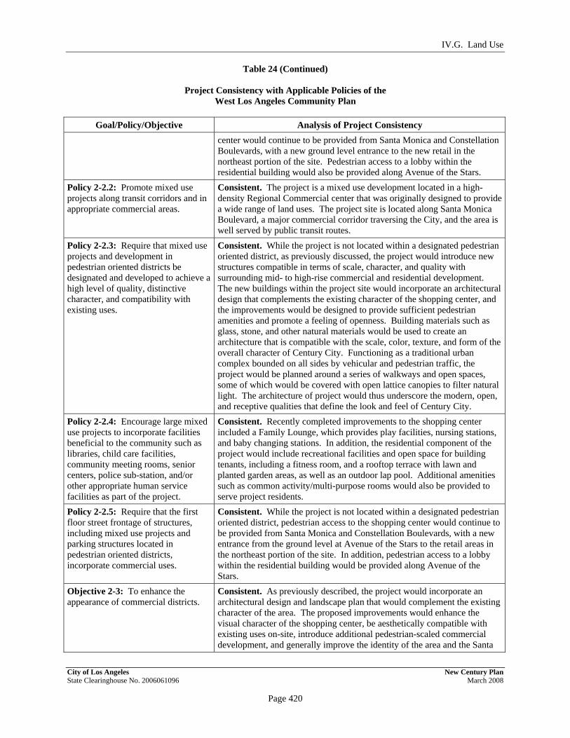
IV.G. Land Use
Table 24 (Continued)
Project Consistency with Applicable Policies of the West Los Angeles Community Plan
City of Los Angeles New Century Plan State Clearinghouse No. 2006061096 March 2008
Page 420
PRELIMINARY WORKING DRAFT – Work in Progress
Goal/Policy/Objective Analysis of Project Consistency center would continue to be provided from Santa Monica and Constellation Boulevards, with a new ground level entrance to the new retail in the northeast portion of the site. Pedestrian access to a lobby within the residential building would also be provided along Avenue of the Stars.
Policy 2-2.2: Promote mixed use projects along transit corridors and in appropriate commercial areas.
Consistent. The project is a mixed use development located in a high-density Regional Commercial center that was originally designed to provide a wide range of land uses. The project site is located along Santa Monica Boulevard, a major commercial corridor traversing the City, and the area is well served by public transit routes.
Policy 2-2.3: Require that mixed use projects and development in pedestrian oriented districts be designated and developed to achieve a high level of quality, distinctive character, and compatibility with existing uses.
Consistent. While the project is not located within a designated pedestrian oriented district, as previously discussed, the project would introduce new structures compatible in terms of scale, character, and quality with surrounding mid- to high-rise commercial and residential development. The new buildings within the project site would incorporate an architectural design that complements the existing character of the shopping center, and the improvements would be designed to provide sufficient pedestrian amenities and promote a feeling of openness. Building materials such as glass, stone, and other natural materials would be used to create an architecture that is compatible with the scale, color, texture, and form of the overall character of Century City. Functioning as a traditional urban complex bounded on all sides by vehicular and pedestrian traffic, the project would be planned around a series of walkways and open spaces, some of which would be covered with open lattice canopies to filter natural light. The architecture of project would thus underscore the modern, open, and receptive qualities that define the look and feel of Century City.
Policy 2-2.4: Encourage large mixed use projects to incorporate facilities beneficial to the community such as libraries, child care facilities, community meeting rooms, senior centers, police sub-station, and/or other appropriate human service facilities as part of the project.
Consistent. Recently completed improvements to the shopping center included a Family Lounge, which provides play facilities, nursing stations, and baby changing stations. In addition, the residential component of the project would include recreational facilities and open space for building tenants, including a fitness room, and a rooftop terrace with lawn and planted garden areas, as well as an outdoor lap pool. Additional amenities such as common activity/multi-purpose rooms would also be provided to serve project residents.
Policy 2-2.5: Require that the first floor street frontage of structures, including mixed use projects and parking structures located in pedestrian oriented districts, incorporate commercial uses.
Consistent. While the project is not located within a designated pedestrian oriented district, pedestrian access to the shopping center would continue to be provided from Santa Monica and Constellation Boulevards, with a new entrance from the ground level at Avenue of the Stars to the retail areas in the northeast portion of the site. In addition, pedestrian access to a lobby within the residential building would be provided along Avenue of the Stars.
Objective 2-3: To enhance the appearance of commercial districts.
Consistent. As previously described, the project would incorporate an architectural design and landscape plan that would complement the existing character of the area. The proposed improvements would enhance the visual character of the shopping center, be aesthetically compatible with existing uses on-site, introduce additional pedestrian-scaled commercial development, and generally improve the identity of the area and the Santa

IV.G. Land Use
Table 24 (Continued)
Project Consistency with Applicable Policies of the West Los Angeles Community Plan
City of Los Angeles New Century Plan State Clearinghouse No. 2006061096 March 2008
Page 421
PRELIMINARY WORKING DRAFT – Work in Progress
Goal/Policy/Objective Analysis of Project Consistency Monica Boulevard commercial corridor. The proposed improvements would also enhance Century City as a walkable community by providing options to live, play, and shop.
Policy 2-3.1: Establish street identity and character through appropriate sign control, landscaping and streetscape improvements; and require that new development be compatible with the scale of adjacent neighborhoods.
Consistent. A landscaping plan designed to complement and enhance the existing character of the project site would be implemented as part of the project. A number of plants in the open air areas of the existing shopping center would be removed and replaced, and plantings of trees, shrubs, and groundcover would continue to be provided throughout the site. The primary project frontages (i.e., along Santa Monica Boulevard and the residential lobby along Avenue of the Stars) would also be landscaped. Any street trees removed during construction of the project would be replaced in accordance with City requirements. In addition, project signage would be provided in accordance with Code requirements and would be compatible with the architecture of the existing and proposed buildings. No new lit signage would be visible from adjacent R1 property to the west. In addition, all signage along Century Park West, Constellation Boulevard, and Santa Monica Boulevard would be of a conservative nature and not flashing, blinking or otherwise animated. As discussed above, the project would be compatible in scale and height with existing buildings within Century City and the taller structures would be located within the central and eastern portions of the site, away from the single-family residential neighborhood to the west.
Policy 2-3.2: Require that commercial projects be designed and developed to achieve a high level of quality, distinctive character and compatibility with surrounding uses and development.
Consistent. As previously described, the project would be designed to achieve a high level of quality with design elements that would complement the existing character of the area. The proposed improvements would enhance the visual character of the shopping center, be aesthetically compatible with existing uses on-site, introduce additional pedestrian-scaled commercial development, and generally improve the identity of the area and the Santa Monica Boulevard commercial corridor. The proposed improvements would also ensure the future vitality of the shopping center and enhance Century City as a walkable community by providing options to live, play, and shop.
Goal 4: Adequate recreation and park facilities which meet the needs of the residents in the community.
Consistent. As discussed above, the residential component of the project would include recreational facilities and open space for building tenants, including a fitness room, and a rooftop terrace with lawn and planted garden areas, as well as an outdoor lap pool. Additional amenities such as common activity/multipurpose rooms would also be provided to serve project residents.
Source: PCR Services Corporation, 2007.
According to the Los Angeles City Planning Department’s August 1, 2007 Trip Allocation Table, 278.605 CATGP Trips remain available within the shopping center, and 1,259.706 CATGP Replacement Trips are available on 1930 Century Park West. In addition, the City has acknowledged, through recorded covenants, that demolition of the existing development

IV.G. Land Use
City of Los Angeles New Century Plan State Clearinghouse No. 2006061096 March 2008
Page 422
PRELIMINARY WORKING DRAFT – Work in Progress
on the 1801 Avenue of the Stars and 1930 Century Park West parcels would result in an additional 4,182.052 and 871.451 CATGP Replacement Trips, respectively. Furthermore, additional CATGP Transfer Trips would be provided to the project site as needed for the new development. Thus, the project would be consistent with the Trip allocations set forth in the CCNSP.
As described in Section II, Project Description, an amendment to the CCNSP is proposed that would formally define the shopping center to include 1801 Avenue of the Stars and 1930 Century Park West, together with 10250 Santa Monica Boulevard. As part of this amendment, the heights of all buildings within the redefined shopping center, including 1801 Avenue of the Stars and 1930 Century Park West, would be measured from the plaza level; this would be consistent with the CCNSP’s current requirement for measuring the heights of structures in the Very Limited Height District No. 1 (1VL) portion of the shopping center. Additionally, the amendment proposes to consider the entire property as a unified site, to allow for the transfer of density and CATGP Trips within the site. With approval of this requested CCNSP amendment, the project’s building heights and density would comply with LAMC and CCNSP requirements. The designated Core Area of the project site (i.e., the central and eastern portions of the site) would have a post-project FAR of 2.8:1, and the designated Buffer Area (i.e., the western portion of the site along Century Park West) would have an FAR of 1.1:1, thus meeting the respective 6:1 and 4.5:1 FAR restrictions. The overall site would have an FAR of 2.4:1. Additionally, in accordance with Section 7 of the CCNSP, the project would not include any fast food restaurant uses.
As previously mentioned, the proposed project would be required to obtain a Project Permit. Table 25 on page 423 provides a discussion of the project findings that the City Planning Commission must make prior to approval of the permit. As discussed above, an amendment to the Century City North Specific Plan is proposed to add the 1801 Avenue of the Stars property and the 1930 Century Park West property to the definition of the shopping center site, as set forth in Section 7 of the CCNSP, in order to consider the entire property as a unified site. Based on the analysis presented above and in Table 25, and with approval of the requested Specific Plan Amendment, the project would be consistent with the CCNSP and thus the necessary findings can be made for the Project Permit. As such, impacts relative to this land use plan would be less than significant.
(e) West Los Angeles Transportation Improvement and Mitigation Specific Plan
As discussed in Section IV.J, Traffic and Circulation, of this Draft EIR, the project would be consistent with the provisions of the West LA TIMP.

IV.G. Land Use
City of Los Angeles New Century Plan State Clearinghouse No. 2006061096 March 2008
Page 423
PRELIMINARY WORKING DRAFT – Work in Progress
Table 25
Project Findings Necessary Prior to Approval of a Project Permit Under the Century City North Specific Plan
Required Finding Analysis of Project Consistency
Section 3.C.1.a: The Project confirms to all of the provisions of this Specific Plan, the West Los Angeles Community Plan and all other applicable provisions of the General Plan.
Consistent. As demonstrated throughout the analysis herein, the project would be substantially consistent with applicable provisions within the CCNSP, the West Los Angeles Community Plan, and the General Plan.
Section 3.C.1.b: The Project has been designed in a way to reasonably assure that it will not cast a shadow for more than two hours, between 8 A.M. and 8 P.M. upon any detached single-family dwelling located outside the CCNSP area.
Consistent. The proposed project includes a 49-story commercial/ residential building that would have the potential to cast shadows onto off-site residential properties. As discussed in detail in Section IV.A., Aesthetics/Visual Resources, the maximum duration of new shading of nearby residential areas generated by the project throughout the year would not exceed two hours between the hours of 8 A.M. and 8 P.M. Thus, the project would comply with the CCNSP shade/shadow requirements.
Section 3.C.1.c: Sufficient provisions have been made, if necessary, to assure the installation of a continuous Pedestrian Corridor in accordance with the provisions of Section 10 of this Ordinance and as shown on the Map.
Consistent. The project would maintain the on-site portion of the designated pedestrian corridor. Specifically, the project would enhance the shopping center’s open air design, with new outdoor promenades, plazas, and open spaces that would provide a continuous pedestrian walkway throughout the shopping center and would connect to the existing Avenue of the Stars pedestrian bridge to the east. The project walkway would also connect to the existing pedestrian crosswalk south of the site near the Macy’s building. Through the incorporation of landscaped areas and walkways that link to adjacent land uses, the project would provide a pedestrian-friendly environment. Further, project construction and operations would not impede the pedestrian corridor features identified in the CCNSP.
Section 3.C.1.d: Sufficient provisions have been made, if necessary, to assure the installation of Pedestrian Crossings in accordance with the provisions of CCNSP Section 10 and as shown on the Map.
Consistent. The project would provide a continuous pedestrian walkway throughout the shopping center that would connect to the existing Avenue of the Stars pedestrian bridge to the east. The project walkway would also connect to the existing pedestrian crosswalk south of the site near the Macy’s retail building. There are currently no plans for the City to install a grade-separated pedestrian crossing to the south across Constellation Boulevard. In any case, the project would not impede any necessary substructure for a future pedestrian crossing at this location. Furthermore, the project would comply with all applicable provisions as set forth in Section 10.B of the CCNSP.
Section 3.C.1.e: The Project has been designed in a manner which adequately screens ventilation, heating and air conditioning ducts, tubes, equipment and other related appurtenances from the view of pedestrians, motorists and occupants of adjacent buildings.
Consistent. The project has been designed to screen all ventilation, heating and air conditioning ducts, tubes, and other such mechanical equipment from the line of sight of pedestrians, motorists, and occupants of adjacent buildings. The primary mechanical rooms would be located on one or more of the parking or retail levels in the central portion of the shopping center, on the top floor of the new portion of the shopping center, and in a mechanical floor at the top of the residential building. Utility connections would be underground. Therefore, the project would comply with this CCNSP requirement.
Section 3.C.1.f: The façade of any parking building has been designed to be compatible in architectural character with
Consistent. A five-story parking structure would be constructed on the southwest portion of the project site (at 1930 Century Park West). The structure would feature a clean design compatible with the architectural

IV.G. Land Use
Table 25 (Continued)
Project Findings Necessary Prior to Approval of a Project Permit Under the Century City North Specific Plan
City of Los Angeles New Century Plan State Clearinghouse No. 2006061096 March 2008
Page 424
PRELIMINARY WORKING DRAFT – Work in Progress
Required Finding Analysis of Project Consistency its principal building and with adjacent existing office, commercial or residential buildings.
character of the shopping center. The western façade of the facility would not be open and would have a landscaped façade. Thus, vehicle headlights and interior lighting would not be directed towards the residents to the east across Century Park West and noise associated with parking activities would be minimized. The architecture of the project as a whole would underscore the modern, open, and receptive qualities that define the look and feel of Century City. All other project parking would occur on subterranean or rooftop levels, and therefore, no parking structure façades would be visible from the street level or above.
Section 3.C.1.g: Consideration has been given by the City Planning Commission to impacts generated by the Project on the vehicular circulation system within the Specific Plan Area and on the sections of Pico, Olympic and Santa Monica Boulevards between one mile easterly and one mile westerly of the boundaries of the Specific Plan Area, including specifically the impacts at those intersections serving the Specific Plan Area at Pico, Olympic and Santa Monica Boulevards, and that mitigation measures, if any, were given due consideration. Such consideration of impacts and mitigation measures shall include, but not be limited to, forecasts of potential traffic from: (1) all Projects within the Specific Plan Area and the area governed by the Century City South Specific Plan for which building permits have been issued, but which have not yet been constructed and (2) all allowable future development permitted under the densities and uses set forth for said areas. These forecasts shall be based on the Trip generation factors contained in the definition of CATGP. Said consideration of impacts and mitigation measures shall be made in writing or reduced to writing and shall be a part of the Project Permit file.
Consistent. As discussed further in Section IV.J, Traffic and Circulation, of this Draft EIR, the project includes a comprehensive traffic study conducted under the direction of the City of Los Angeles Department of Transportation (LADOT). The traffic analysis evaluates project impacts on the local and regional roadway network and takes into account the effects of traffic generated by cumulative development within the area. An analysis of the project relative to CATGP generation and requirements is also provided. As concluded in the traffic analysis, no significant impacts relative to Pico, Olympic, and Santa Monica Boulevards would occur after implementation of mitigation measures. As such, the project would comply with this CCNSP requirement.
Section 3.C.1.h: Adequate sewers and similar public utilities, facilities and services, other than those considered pursuant to CCNSP Section 3.C.1.g, exist or will exist to service the intensity and design of the proposed Project and other development in the CCNSP Area.
Consistent. The availability of wastewater infrastructure and other utility services as well as the projected service demands of the project are discussed in the Initial Study, included as Appendix A of this Draft EIR. Available services are summarized as follows:
(1) Sewer—The project site is served by existing sewer lines, and wastewater treatment services are provided by the City of Los Angeles Department of Public Works. According to the City Bureau of

IV.G. Land Use
Table 25 (Continued)
Project Findings Necessary Prior to Approval of a Project Permit Under the Century City North Specific Plan
City of Los Angeles New Century Plan State Clearinghouse No. 2006061096 March 2008
Page 425
PRELIMINARY WORKING DRAFT – Work in Progress
Required Finding Analysis of Project Consistency Engineering, the sewer system in the project area is adequately sized to serve the proposed project. Wastewater would be treated at the Hyperion Treatment Plant (HTP) and would not exceed treatment requirements under the HTP allocation program.
(2) Storm Drains—Existing storm drains in the area have adequate capacity to accommodate post-development storm water runoff from the site as determined by the City of Los Angeles Bureau of Engineering. In addition, the project would include appropriate drainage improvements on-site to convey anticipated stormwater flows and would comply with applicable Standard Urban Stormwater Mitigation Plan (SUSMP) and Los Angeles Regional Water Quality Control Board (LARWQCB) requirements.
(3) Solid Waste—Solid waste generated by construction and operation of the project would be accommodated by existing landfills in Los Angeles County. Construction waste would include demolition materials and excavated soils, both of which would be reused and/or recycled to the extent feasible. During project operations, solid waste would continue to be collected and transported by a private contractor, and recycling programs would be implemented on-site in order to minimize waste.
(4) Electrical Power— Electricity transmission to the project site is provided and maintained by the Los Angeles Department of Water and Power (LADWP). The project-related annual electricity demand would represent 0.07 percent of the total forecasted demand in 2012, and is therefore within the anticipated service capabilities of LADWP.
(5) Natural Gas— Natural gas is provided to the project site by the Southern California Gas Company (SCGC). The projected annual consumption of natural gas associated with the proposed project would represent a minor percentage of total demand and would be well within the service capabilities of SCGC.
Project impacts relating to water supplies and infrastructure are analyzed in Section IV.K., Water Supply, of this Draft EIR. As discussed therein, water would continue to be provided to the project site by the City of Los Angeles Department of Water and Power. Project construction would include all necessary on- and off-site improvements and connections to adequately link the project to the existing City water system. In addition, DWP has stated that sufficient water supplies exist to accommodate the project.
Since adequate sewers and other similar public utilities, facilities and services exist or will exist to service the intensity and design of the proposed project, the project is considered consistent with this CCNSP requirement.
Section 3.C.1.i: Sufficient provisions have been made to assure the installation of any on-site or off-site improvements deemed necessary by the City Engineer to
Consistent. As discussed above, adequate capacity exists in the water, wastewater, and stormwater conveyance systems that serve the project site. Construction of the project would include all necessary on-site and off-site infrastructure improvements and connections to adequately link

IV.G. Land Use
Table 25 (Continued)
Project Findings Necessary Prior to Approval of a Project Permit Under the Century City North Specific Plan
City of Los Angeles New Century Plan State Clearinghouse No. 2006061096 March 2008
Page 426
PRELIMINARY WORKING DRAFT – Work in Progress
Required Finding Analysis of Project Consistency accommodate any cumulative impacts generated by the Project on existing sewers or other similar public utilities, facilities and services, other than those considered pursuant to CCNSP Section 3.C.1.g.
the project to the City’s existing systems. The design of these connections would be developed by a registered engineer and reviewed by the Los Angeles Department of Public Works. LADOT would review any construction or excavation in a public right-of-way. Cumulative effects on utility conveyances would be mitigated on a project-by-project fair share basis. With adherence to the requirements of the Department of Public Works and LADOT, the project would comply with this CCNSP requirement.
Source: PCR Services Corporation, 2007.
(2) Los Angeles Municipal Code (LAMC)
As indicated above, the entire project site is zoned as C2 Commercial pursuant to the City of Los Angeles Planning and Zoning Code. The commercial uses potentially contemplated for the shopping center expansion (e.g., various types of retail shops, restaurants/cafés, and entertainment uses, among others), along with the proposed office uses, associated parking, and signage, are all permitted within the C2 zone. High density multiple-family development is also permitted in the C2 zone, as long as it complies with the area, density, parking and other requirements of the R4 zone. Table 26 on page 427 provides an analysis of project consistency with applicable LAMC size, setback, height, open space, and parking requirements for the C2 and R4 zones.
As described above, the project would require a new CUP per LAMC Section 12.24 to replace the 1988 approval for the on-site sale and service of alcoholic beverages, primarily to clarify that the CUP would apply to the proposed expanded shopping center site. The Applicant seeks to increase the number of establishments serving alcohol from 18, of which 15 have been utilized to date, to 26. The establishments serving alcoholic beverages will continue to be a part of a carefully controlled first-class shopping center, and appropriate security measures will be implemented. The service of alcoholic beverages has come to be accepted as a normal and desirable complement to food service in fine quality restaurants. As such, the requested CUP approval is in keeping with the operation of the regional shopping center.
The project would also necessitate a Zoning Administrator Determination to allow shared use parking among the office, retail, restaurant, and theater uses in the shopping center portion of the site. A parking analysis for the project is provided in Section IV.J, Traffic and Circulation, of this Draft EIR, and demonstrates that, due to the mix of uses, parking demand will not exceed the supply of parking provided for the project. Specifically, the on-site parking supply will be

IV.G. Land Use
City of Los Angeles New Century Plan State Clearinghouse No. 2006061096 March 2008
Page 427
PRELIMINARY WORKING DRAFT – Work in Progress
Table 26
Consistency of Proposed Project with Applicable Land Use Regulations of the Los Angeles Municipal Code
Code Section Code
Requirement Analysis
of Consistency C2 Zone Lot and Yard Area: Commercial Portion of Project 12.14 C.1 Front Yard—Not required. Consistent. Since front yards are not required within
the C2 zone, the project would be consistent with this requirement.
12.14 C.2 Side and Rear Yards—Not required for buildings erected and used exclusively for commercial purposes. For all portions of buildings erected and used for residential purposes, side and rear yard conforming to the requirements of the R4 Zone shall be provided and maintained at the floor level of the first story used in whole or in part for residential purposes.
Consistent. Since side and rear yards are not required for commercial structures, such as the shopping center, within the C2 zone, the project would be consistent with this requirement. Refer to the analysis below regarding the proposed residential building.
12.14 C.3 Lot Area— No lot area requirements for buildings erected and used exclusively for commercial purposes. The lot area requirements of the R4 Zone (Section 12.11 C.4) shall apply to all portions of buildings used for residential purposes.
Consistent. Refer to the analysis below regarding the proposed residential building.
12.14 C.4 Loading Space—As required by Section 12.21 C.6. Exceptions to area regulations are provided for in Section 12.22 C.
Consistent. Loading spaces would be provided well in excess of Code requirements. Loading areas would be provided within the project site to serve the existing and proposed retail uses, and restaurants, the existing grocery store, and the proposed residential building. Several of these loading areas will have common access and egress along the site perimeter from the existing service tunnel running from Constellation Boulevard to Santa Monica Boulevard. Additional common loading access and egress for loading areas is located off of Constellation Boulevard east of Century Park West.
C2 Zone Lot and Yard Area: Residential Portion of Project a 12.14.C.1 Front Yard—Not required. Consistent. Since front yards are not required within
the C2 zone for residential uses, the project will be consistent with the requirement.
12.11 C.2 Side Yard (as per R4 zoning) – a maximum 16-foot side yard shall be required for structures exceeding six stories in height.
Consistent. The proposed residential building would include minimum 16-foot side yard setbacks along a portion of Santa Monica Boulevard and an internal lot line.
12.11 C.3 Rear Yard (as per R4 Zoning)—There shall be a rear yard of not less than 15 feet in depth. For a building more than three stories in height, one foot shall be
Consistent. The upper residential portion of the 1801 Avenue of the Stars building would be stepped back from Avenue of the Stars and would include a 20-foot rear yard setback. The lower three stories of

IV.G. Land Use
Table 26 (Continued)
Consistency of Proposed Project with Applicable Land Use Regulations of the Los Angeles Municipal Code
City of Los Angeles New Century Plan State Clearinghouse No. 2006061096 March 2008
Page 428
PRELIMINARY WORKING DRAFT – Work in Progress
Code Section Code Requirement
Analysis of Consistency
added to the depth of the rear yard for each additional story above the third story, but such rear yard shall not exceed 20 feet.
the building, comprised of retail uses, would not be subject to this requirement and would have a 0-foot rear yard setback.
12.11 C.4 Dwelling Unit Density—One dwelling unit shall be permitted per 400 square feet of buildable lot area.
Consistent. The net area of the existing 1801 Avenue of the Stars parcel is approximately 104,879 square feet.40 Divided by 400 square feet per dwelling unit, this land area would allow 262 dwelling units consistent with the R4 zone. The project would develop 262 dwelling units.
Parking 12.21 A.4 (a) For Dwelling Units—Off -street
automobile parking shall be provided at 1 space for each dwelling unit containing less than three habitable rooms; 1.5 spaces for each dwelling units containing three habitable rooms; and 2 spaces for each dwelling unit containing more than three habitable rooms.b
Consistent. The proposed project would provide 2.5 parking spaces per dwelling unit (2.0 resident parking spaces and 0.5 guest parking space per dwelling unit), or 655 spaces for resident and guest use, located in subterranean parking levels beneath the new building at 1801 Avenue of the Stars.
12.21 A.4 (c) For Commercial and Industrial Buildings—Except as otherwise provided in Subparagraphs (1) through and including (7) below, there shall be at least one automobile parking space for each 500 square feet of combined floor area contained within all the office, business, commercial, research and development buildings, and manufacturing or industrial buildings on any lot.
Consistent. Based on a strict application of Zoning Code parking requirements, the project would require a total of 4,990 spaces, including:
2,491 parking spaces to serve existing shopping center uses (by permit);
1,305 parking spaces to serve new retail uses (1 space per 250 square feet for 326,326 square feet);
326 parking spaces to serve new restaurant uses (1 space per 100 square feet for 32,555 square feet);
655 parking spaces to serve the new residential uses (see above);
213 parking spaces to serve the new office uses (1 space per 500 square feet for 106,523 square feet).
Parking areas associated with the shopping center would include subterranean and rooftop parking within the existing shopping center as well as in the proposed parking structure located at 1930 Century Park West. Collectively, these parking areas would provide 3,874 parking spaces. As previously discussed, the Applicant seeks a Zoning
40 ZIMAS parcel profile for 1801 Avenue of the Stars (http://zimas.lacity.org, accessed March 26,2007).

IV.G. Land Use
Table 26 (Continued)
Consistency of Proposed Project with Applicable Land Use Regulations of the Los Angeles Municipal Code
City of Los Angeles New Century Plan State Clearinghouse No. 2006061096 March 2008
Page 429
PRELIMINARY WORKING DRAFT – Work in Progress
Code Section Code Requirement
Analysis of Consistency
Administrator Determination to allow shared use parking among the office, retail, restaurant and theater uses (not the residential uses) in the shopping center portion of the site. With approval of shared use parking, the proposed parking supply would be sufficient to meet project parking demands.
12.21 A.4 (c)(3) Restaurants and Bars, General—There shall be at least one automobile parking space for each 100 square feet of gross floor area included within the total square footage of any restaurant, cafe, coffee shop, tea room, fast food establishment, bar, night club, or any similar establishment, which dispenses food or refreshments or provides dancing or live entertainment. This requirement shall only apply to an establishment which has a gross floor area greater than 1,000 square feet. An establishment which provides no seating and exclusively dispenses food or refreshments to be eaten off the premises is not included in this definition and shall instead meet the requirement for general retail uses.
Consistent. See analysis above.
12.21 A.4 (c)(4) Restaurant, Small—If a restaurant, cafe, coffee shop, or other dining establishment has a gross floor area of 1,000 square feet or less, then it need provide only one automobile parking space for each 200 square feet of gross floor area. However, if such an establishment has a separate bar, or provides dancing or live entertainment, then additional parking shall be provided to meet the requirements for general restaurants set forth in Subparagraph (3) of this paragraph.
Consistent. See analysis above.
12.21 A.4 (c)(5) Retail Stores, General—Retail establishments and discount wholesalers selling to the general public, shall provide at least four automobile parking spaces for each 1,000 square feet of gross floor area.
Consistent. See analysis above.

IV.G. Land Use
Table 26 (Continued)
Consistency of Proposed Project with Applicable Land Use Regulations of the Los Angeles Municipal Code
City of Los Angeles New Century Plan State Clearinghouse No. 2006061096 March 2008
Page 430
PRELIMINARY WORKING DRAFT – Work in Progress
Code Section Code Requirement
Analysis of Consistency
Building Height 12.21.2 B.1 No height limit is established for Height
District 2. Consistent. As no height limit is established for properties within Height District No. 2, which includes the property at 1801 Avenue of the Stars, the proposed residential building height would be consistent with this provision.
12.21.2 B.2 The total floor area contained in all the main buildings on a lot in Height District No. 1 shall not exceed three times the buildable area of said lot. Portions of Height District No. 1 may be designated as being in an “L” Limited Height District and no building or structure in Height District No. 1-L shall exceed six stories nor shall it exceed 75 feet in height. Portions of Height District No. 1 may be designated as being in a “VL” Very Limited Height District and no building or structure in Height District No. 1-VL shall exceed three stories nor shall it exceed 45 feet in height. Notwithstanding that limitation, portions of Height District No. 1-VL that are also in the RAS3 or RAS4 zones shall not exceed 50 feet in height.
Consistent. The central portion of the shopping center is located within the 1L height district and would be subject to a 75-foot maximum height.
The western portion of the project site (i.e., along Century Park West) falls within the 1VL height district and thus is subject to a 45-foot maximum height.
The project proposes an amendment to the CCNSP which would expand the definition of the shopping to include 1801 Avenue of the Stars and 1930 Century Park West, and to measure the heights of all buildings within the redefined shopping center from the plaza level. The amendment would also acknowledge that there should be no limit on the number of stories within the C2-1VL portion of the shopping center so long as the 45 foot height limitation is not exceeded. The parking facility at 1930 Century Park West, within the C2-1VL portion of the site, is 45 feet in height as measured from the plaza level, and thus would be consistent with the CCNSP with approval of this amendment. Additionally, the buildings in the C2-1L portion of the site would be a maximum of 75 feet in height as measured from the plaza level, and thus also consistent with the CCNSP with approval of the requested amendment. Significantly, the new parking facility would be lower in height than the office building it would replace.
12.21.2 B.3 (Permitted Floor Area of Structures in Century City)
The total floor area within buildings in Height District 2 shall not exceed six times the buildable area of the lot.
Consistent. With approval of the project’s requested CCNSP amendment, to treat the entire property as a unified development, the project would be consistent with the Code’s floor area requirements. The project would have an overall FAR of 2.4:1, below the maximum FAR allowed.
Residential Open Space 12.21 G.2
New construction shall have 100 square feet of usable open space for each unit having less than three habitable rooms; 125 square feet of usable open space for each unit having three habitable rooms;
Consistent. Based on the proposed unit mix (all units would have more than three habitable rooms), approximately 45,850 square feet of open space would be required. The project would provide approximately 46,000 square feet (1.06 acres) of

IV.G. Land Use
Table 26 (Continued)
Consistency of Proposed Project with Applicable Land Use Regulations of the Los Angeles Municipal Code
City of Los Angeles New Century Plan State Clearinghouse No. 2006061096 March 2008
Page 431
PRELIMINARY WORKING DRAFT – Work in Progress
Code Section Code Requirement
Analysis of Consistency
and 175 square feet of usable open space for each unit having more than three habitable rooms. Usable open space excludes parking areas, aisles, driveways, and required front and side yards.
common usable open space within the rooftop recreation area, in excess of these requirements. Approximately 30,200 square feet of this area would be planted. In addition, private outdoor areas intended for passive recreation would be provided in the form of residential balconies.
a Residential uses consistent with the R4 (Multiple Dwelling) zone are permitted in the C2 (Commercial) zone. b The policy of the Los Angeles Department of City Planning Advisory Agency is to require 2.0 resident parking spaces
and 0.5 guest parking space per dwelling unit for projects that require Advisory Agency discretionary actions. The project would be consistent with this policy.
Source: LAMC Chapter I, Article 2, and PCR Services Corporation, 2007.
adequate to accommodate the demand for parking during non-holiday peak periods and the continued practice of securing off-site parking spaces would ensure that adequate parking would be available during peak periods of the holiday season. With the proposed on-site parking supply, as well as the provision of off-site parking spaces, the supply would be sufficient to accommodate the peak demand.
As discussed in Section IV.E, Hazards and Hazardous Materials, the project would also be consistent with the Methane Zone building regulations. In addition the project would comply with LAMC standards for driveway access, parking stall dimensions, and loading areas. Thus, with approval of the requested discretionary actions described above, the project would be consistent with the requirements of the LAMC, and no significant land use impacts associated with the City Municipal Code would occur.
(3) Consistency with Regional Plans and Applicable Policies
An evaluation of the consistency of the project with relevant SCAG policies was completed and is provided in Table 27 on page 432. As indicated therein, the project would support the primary SCAG policies set forth in the Regional Comprehensive Plan and Guide. Table 27 also includes an analysis of the project’s consistency with the applicable goals/polices in SCAG’s 2004 Regional Transportation Plan and Growth Vision Report. As demonstrated therein, the project would be substantially consistent with the goals/policies set forth in each of these SCAG documents.

IV.G. Land Use
City of Los Angeles New Century Plan State Clearinghouse No. 2006061096 March 2008
Page 432
PRELIMINARY WORKING DRAFT – Work in Progress
Table 27
Consistency with SCAG Policies
# Policy Project Consistency Analysis Regional Comprehensive Plan and Guide (RCPG) Policies Growth Management Chapter 3.01 The population, housing, and jobs
forecasts which are adopted by SCAG’s Regional Council and that reflect local plans and policies shall be used by SCAG in all phases of implementation and review.
Consistent. The 262 residential units and estimated associated residential population of 553 residents would be consistent with the West Los Angeles Community Plan forecasted growth. In addition, the increase in employment would also be consistent with the employment forecasted within the West Los Angeles Community Plan. As such, the project would be consistent with SCAG population, housing and employment forecasts.
3.03 The timing, financing, and location of public facilities, utility systems, and transportation systems shall be used by SCAG to implement the region's growth policies.
Consistent. The project site is located in an urban area already served by an existing infrastructure and transportation system. The proposed project would provide new connections to existing utility systems and would include on-site safety and fire prevention measures as well as security features in the buildings that reduce demand for fire and police services. Furthermore, on-site amenities, such as active and passive recreation opportunities, would be provided for project residents. In addition, on-site driveways would ensure that the existing transportation system would not be significantly impacted. Therefore, the proposed project would not conflict with this RCPG policy.
3.05 Encourage patterns of urban development and land use which reduce costs on infrastructure construction and make better use of existing facilities
Consistent. The proposed project is located in the highly urbanized Century City area, which is already served by existing infrastructure. Thus, the proposed project would minimize infrastructure costs and would make better use of existing facilities compared to similar projects in less centralized locations. Therefore, the project would be consistent with his RCPG policy.
3.09 Support local jurisdictions' efforts to minimize cost of infrastructure and public service delivery, and efforts to seek new sources of funding for development and the provision of services
Consistent. As discussed above, the proposed project is located in an urbanized area currently served by local utilities, public services, and transportation systems. The project would provide upgrades to existing infrastructure as required for development of the proposed project. Additionally, the project would maintain and expand retail, property, and other City tax revenues that may be used to support local infrastructure improvements. Thus, the proposed project would be consistent with this RCPG policy.

IV.E Land Use
Table 27 (Continued)
Consistency with SCAG Policies
City of Los Angeles New Century Plan State Clearinghouse No. 2006061096 March 2008
Page 433
PRELIMINARY WORKING DRAFT – Work in Progress
# Policy Project Consistency Analysis 3.11 Support provisions and incentives
created by local jurisdictions to attract housing growth in job rich subregions and job growth in housing rich subregions
Consistent. The project is located within a major employment and economic area. By developing new residential uses, the project would help meet the housing needs of this area. Therefore, the project would be consistent with this RCPG policy.
3.12 Encourage existing or proposed local jurisdictions’ programs aimed at designing land uses which encourage the use of transit and thus reduce the need for roadway expansion, reduce the number of auto trips and vehicle miles traveled, and create opportunities for residents to walk or bike.
Consistent. The project is adjacent to the Santa Monica Boulevard Transit Parkway, a designated priority non-motorized route under the Transportation Element of the General Plan (Map E). The Santa Monica Boulevard Transit Parkway contains dedicated bicycle and transit lanes. The project would also be adjacent to bus transit on Avenue of the Stars and Constellation Boulevard and would include bicycle parking spaces. The proximity to bus transit and bicycle lanes would facilitate alternative modes of travel and, therefore, would be consistent with SCAG policies. The location of residential uses within close proximity to jobs, as described in the analysis of Policy 3.05 above, would implement SCAG policies with regard to jobs/housing balance by reducing commuting distances and also encouraging alternative travel modes, such as cycling and walking.
3.13 Encourage local jurisdiction's plans that maximize the use of existing urbanized areas accessible to transit through infill and redevelopment
Consistent. The project would redevelop a site used for existing office and commercial uses with new retail, residential and office uses. The project site has access to nearby transit facilities. The project would be consistent with this RCPG policy.
3.14 Support local plans to increase density of future development located at strategic points along the regional commuter rail, transit systems and activity centers
Consistent. The project site is located near transit facilities along the active Santa Monica Boulevard Transit Parkway and along Constellation Boulevard. Furthermore, the project site is located within Century City, an area of employment and economic activity that is well served by existing public facilities and infrastructure. As such, the proposed project would be consistent with this RCPG policy.
3.15 Support local jurisdictions strategies to establish mixed-use clusters and other transit oriented developments around transit stations and along transit corridors.
Consistent. The proposed project is a mixed-use development that would be located near transit facilities along the active Santa Monica Boulevard Transit Parkway and along Constellation Boulevard. As such, the proposed project would be consistent with this RCPG policy.

IV.E Land Use
Table 27 (Continued)
Consistency with SCAG Policies
City of Los Angeles New Century Plan State Clearinghouse No. 2006061096 March 2008
Page 434
PRELIMINARY WORKING DRAFT – Work in Progress
# Policy Project Consistency Analysis 3.17 Support and encourage settlement
patterns which contain a range of urban densities.
Consistent. The project would introduce new retail and office uses that would enhance existing commercial uses in the area and would be compatible with the residential uses to the west across Century Park West. The proposed project would also introduce new residential development within the area, which would be compatible with surrounding commercial uses. As such, the proposed project would be consistent with this RCPG policy.
3.18 Encourage planned development in locations least likely to cause environmental impact.
Consistent. The project would result in the redevelopment of a site located in an urbanized area and developed with existing retail and office uses. Development of the project would be compatible with and support existing and future land uses. Furthermore, the project would be served by existing infrastructure within the area and would reduce vehicle trips by placing residential uses within an established employment hub and in close proximity to public transit facilities. Overall, the urbanized location of the project would minimize the potential for environmental impacts. Therefore, the proposed project would be consistent with this RCPG policy.
3.20 Support the protection of vital resources such as wetlands, groundwater recharge areas, woodlands, production lands, and land containing unique and endangered plants and animals.
Consistent. The project site does not contain, nor is it adjacent to, vital environmental resources such as wetlands, groundwater recharge areas, and lands containing biotic habitat.
3.21 Encourage the implementation of measures aimed at the preservation and protection of recorded and unrecorded cultural resources and archaeological sites.
Partially Consistent. The potential impact of the project relative to archaeological and paleontological resources has been evaluated in the Initial Study, which is contained in Appendix A of this Draft EIR. It is concluded that the impact of the project relative to these resources would be less than significant. The project would result in the removal of the building located at 1801 Avenue of the Stars. As discussed in Section IV.C, Historic Resources, the building is representative of a design type that is characteristic of a particular period in state architectural history, and the building is also the product of an important creative individual’s firm, Welton Becket and Associates. However, the building is not a widely recognized or noteworthy example within the Becket firm’s body of work, cannot be directly associated with Welton Becket, himself, and has outlasted the context in Century City for which it was designed and built. Notwithstanding the foregoing points of detraction, however, the building and its associated contributing features and objects are, for purposes of conservative

IV.E Land Use
Table 27 (Continued)
Consistency with SCAG Policies
City of Los Angeles New Century Plan State Clearinghouse No. 2006061096 March 2008
Page 435
PRELIMINARY WORKING DRAFT – Work in Progress
# Policy Project Consistency Analysis assessment, considered potentially eligible for the California Register under Criterion 3 and potential eligibility as a City of Los Angeles Historic-Cultural Monument. Thus, the project would not be fully consistent with this goal.
3.22 Discourage development, or encourage the use of special design requirements, in areas with steep slope, high fire, flood, and seismic hazards.
Consistent. The project site is not subject to hazards associated with high fire or flood. The geological implications of the development, including slope and seismic hazards, are addressed in the Initial Study, which is contained in Appendix A of this Draft EIR. The Initial Study concluded that geologic impacts would be less than significant.
3.23 Encourage mitigation measures that reduce noise in certain locations, measures aimed at preservation of biological and ecological resources, measure that would reduce exposure to seismic hazards, minimize earthquake damage and to develop emergency response and recovery plans.
Consistent. As discussed in Section IV.H, Noise, mitigation measures are recommended to minimize construction-related noise levels. No species identified as a candidate, sensitive, or special status species occur on the project site. In addition the project site is developed and located in an urbanized area. The proposed project would be required to comply with all applicable City building standards and regulations with regard to seismic safety to minimize exposure to seismic hazards. The project would maintain adequate access for fire and emergency vehicles as required by the LAFD. Therefore, operation of the project would not impair implementation or physically interfere with an adopted emergency response plan or emergency evacuation plan. Therefore, the proposed project would be consistent with this RCPG policy.
3.24 Encourage efforts of local jurisdictions in the implementation of programs that increase the supply and quality of housing and provide affordable housing as evaluated in the Regional housing needs Assessment.
Partially Consistent. The residential component would provide 262 residential uses that would increase housing supply within a variety of unit types. However, the project would not provide affordable housing units.
3.27 Support local jurisdictions and other service providers in their efforts to develop sustainable communities and provide, equally to all members of society, accessible and effective services such as public education, housing, health care, child care, social services, recreational facilities, law enforcement, and fire protection.
Consistent. The proposed project would provide a mix of commercial uses and housing that would support the economic future of the region in an area in which the necessary infrastructure is in place. With development of the proposed project, economic opportunities would increase during construction and ongoing operation of the project. In addition, the project would improve the community's tax base that would allow greater provisions of public services. Furthermore, on-site amenities, such as active and passive recreation opportunities, would be provided for project residents. The proposed project would be consistent with this RCPG policy.

IV.E Land Use
Table 27 (Continued)
Consistency with SCAG Policies
City of Los Angeles New Century Plan State Clearinghouse No. 2006061096 March 2008
Page 436
PRELIMINARY WORKING DRAFT – Work in Progress
# Policy Project Consistency Analysis Regional Mobility Chapter Foster Economic Vitality through
promoting transportation strategies that support and encourage economic vitality within the region, and assist in developing the Southern California economic base
Consistent. The proposed mixed-use project would help to ensure the economic vitality of an existing shopping center and would include housing within an area that is a mature employment hub. The project is also adjacent to the Santa Monica Transportation Parkway and the new Metropolitan Transportation Authority transit plaza at Constellation Boulevard. As such, the proposed project would be consistent with this RCPG policy.
Foster Economic Vitality by promoting transportation strategies that reduce public and private costs, and enhance the region's competitive position
Consistent. The proposed development project with a mix of commercial and residential uses will enhance the vitality of an existing shopping center and will foster the growth of pedestrian-oriented community by developing a pedestrian friendly community. The mixed use development will thus enhance the region's competitive position as a premier "live, work, play" destination. As such, the proposed project would be consistent with this RCPG policy.
Enhance the Environment by supporting transportation strategies that minimize impacts on the environment
Consistent. The proposed mixed-use project enhances the environment by encouraging development in and around activity centers, existing public transportation facilities, indirectly fostering a pedestrian-oriented community and developing pedestrian friendly facilities, thereby reducing vehicle trips, congestion, and vehicle emissions that impact the environment. As such, the proposed project would be consistent with this RCPG policy.
Enhance the Environment by supporting transportation policies and actions to meet state and federal air quality goals and objectives.
Consistent. The proposed project enhances the environment by developing new retail and residential uses in proximity to an activity center and existing public transportation facilities. These combined uses result in a reduction in vehicle miles traveled and associated air quality emissions. As such, the proposed project would be consistent with this RCPG policy.
Reduce Energy Consumption by supporting transportation strategies and investments that decrease the region's dependence on traditional fossil fuels
Consistent. The proposed development would provide a mix of commercial and residential uses within a mature employment hub. In addition, the project would foster the growth of a pedestrian-oriented community by developing a pedestrian friendly environment. Thus, the project would support transportation strategies and investments that decrease the region's dependence on traditional fossil fuels. As such, the proposed project would be consistent with this RCPG policy.

IV.E Land Use
Table 27 (Continued)
Consistency with SCAG Policies
City of Los Angeles New Century Plan State Clearinghouse No. 2006061096 March 2008
Page 437
PRELIMINARY WORKING DRAFT – Work in Progress
# Policy Project Consistency Analysis Reduce Energy Consumption by
encouraging non-motorized trips. Consistent. The project would provide a new residential base to support the existing retail, restaurant, entertainment, and office uses within the area. With a greater balance of office and residential uses within the locale, daytime and nighttime activity would be enhanced. Additionally, the integration of 262 new residential units with the shopping center would reduce vehicle trips for new residents and encourage pedestrian activity related to shopping and entertainment. As such, the proposed project would be consistent with this RCPG policy.
Promoting Transportation-Friendly Development by encouraging land-use development patterns that complement transportation investments
Consistent. The project is adjacent to the Santa Monica Boulevard Transit Parkway, a designated priority non-motorized route under the General Plan Transportation Element (Map E). The Santa Monica Boulevard Transit Parkway contains dedicated bicycle and transit lanes. The project would also be adjacent to bus transit on Avenue of the Stars and Constellation Boulevard and would include bicycle parking spaces. Thus, the project would complement transportation investments.
Promoting Transportation-Friendly Development by fostering land use decision that encourage alternatives to the auto.
Consistent. The proposed project encourages alternative modes of transportation by locating new retail and residential uses along a major transit corridor (Santa Monica Boulevard). In addition, the mixed-use development would provide housing within an established employment hub and would enhance an existing shopping center. Enhanced pedestrian paths and landscaped plazas would also be provided to encourage pedestrian activity. In addition, the project is located adjacent to the Santa Monica Transit Parkway and to a new transit center along Constellation Boulevard. As such, the proposed project would be consistent with this RCPG policy.
Housing Chapter Providing an adequate supply and
availability of housing by reducing major components of new housing costs.
Consistent. The residential component of the project includes 262 residential units. The infill nature of the project, the density of the proposed housing, and available infrastructure, all support consistency with this RCPG policy.
Promoting a mix of housing opportunities region wide through social equality and equal housing opportunities.
Partially Consistent. The project's 262 multi-family residential uses would include a mix of unit types. Thus, the project would be partially consistent with this RCPG policy.

IV.E Land Use
Table 27 (Continued)
Consistency with SCAG Policies
City of Los Angeles New Century Plan State Clearinghouse No. 2006061096 March 2008
Page 438
PRELIMINARY WORKING DRAFT – Work in Progress
# Policy Project Consistency Analysis Open Space and Conservation Chapter Core Actions:
• Increase the accessibility to open space lands for outdoor recreation.
• Promote self-sustaining regional recreation resources and facilities.
Consistent. The project would provide landscaped pedestrian pathways through the project site, as well as common recreational facilities and open space areas in accordance with LAMC requirements. Therefore, the project would support regional facilities by reducing demand for open space by the project’s residents.
Regional Transportation Plan (RTP) Policies All existing and new public transit
services, facilities, and/ or systems shall be fully accessible to persons with disabilities as required by applicable sections of the 1990 Americans with Disabilities Act
Consistent. The proposed project site is located in an area in which existing public transit service infrastructure is already available and complies with the applicable sections of the 1990 Americans with Disabilities Act. Therefore, the proposed project would not conflict with this RTP policy.
Transportation investments shall be based on SCAG’s adopted Regional Performance Indicators: This policy is directed toward SCAG activities pertaining to the implementation of its own policies and to agencies with jurisdiction over the management of transportation systems (e.g., Caltrans, MTA, City transportation departments, etc.). The performance standards set levels of service and/or improvements that can be used to monitor the quality of transportation systems (e.g., improve travel speeds by 10 percent, sustain system performance at a cost of $20 per capita, etc.).
Consistent. As the proposed project would not be responsible for monitoring or measuring the performance of regional transportation, this policy is not directly applicable to the project. However, the policy is intended to encourage land use and transportation planning in a manner that would cause favorable outcomes for the performance indicators. The project’s development characteristics are consistent with design principles that are considered to make positive contributions to the performance of the transportation system. For example, the project would provide multi-family housing units in a jobs rich area, providing workers the opportunity to live closer to their work place, and avoid long commutes that adversely affect the performance indicators. Further, the project would be constructed in an area of existing transportation infrastructure in which the city streets and transit would be maintained and operated. The project supports the use of alternative transportation modes such as transit and walking. To the extent that these modes are used by project residents or visitors, due to their immediate availability, the measured levels of the performance indicators would be improved.
Ensuring safety, adequate maintenance, and efficiency of operations on the existing multi-modal transportation system will be RTP priorities and will be balanced against the need for system expansion investments.
Consistent. While the proposed project would have the potential to add a fair amount of new transit riders to existing alternative means of transportation, it is not anticipated that the introduction of new transit riders brought on by the project would exceed the capacity of the available alternative transportation facilities, as transit capacity is generally not an issue in the region. As such, the proposed project is not anticipated to

IV.E Land Use
Table 27 (Continued)
Consistency with SCAG Policies
City of Los Angeles New Century Plan State Clearinghouse No. 2006061096 March 2008
Page 439
PRELIMINARY WORKING DRAFT – Work in Progress
# Policy Project Consistency Analysis significantly impact public transit to require expansion of transportation systems. Therefore, the proposed project would not conflict with this RTP policy.
RTP land uses and growth strategies that differ from currently expected trends will require a collaborative implementation program that identifies required actions and policies by all affected agencies and sub regions.
Consistent. The project supports growth as anticipated in the SCAG forecasts. No actions are required to address variations from the strategies.
HOV gap closures that significantly increase transit and rideshare usage will be supported and encouraged, subject to Policy #1
Consistent. The project site is located in an area in which direct transit service is readily available and is accessible by public transit from most areas of the Los Angeles Metropolitan region when transfer opportunities are considered. The proposed project would provide a greater number of residents with access to public transit. The project would not interfere with the efforts to support and encourage HOV gap closures and, as such, would not conflict with this RTP policy.
Growth Vision Report Principle 1: Improve mobility for all
residents • Encourage transportation investments
and land use decisions that are mutually supportive.
• Locate new housing near existing jobs and new jobs near existing housing.
• Encourage transit-oriented development.
• Promote a variety of travel choices
Consistent. The proposed project is an infill development within an existing, high-density urban area. The project would provide 262 housing units, in a jobs-rich area with adjacent entertainment uses. The project would be located adjacent to or within a short walk to several alternative transportation facilities, which directly or indirectly provide regional service.
Principle 2: Foster livability in all communities • Promote infill development and
redevelopment to revitalize existing communities.
• Promote developments, which provide a mix of uses.
• Promote “people scaled,” walkable communities.
• Support the preservation of stable, single-family neighborhoods.
Consistent. The project would provide an infill development with a mix of uses including residential uses that would be located within an established employment hub and retail uses that would enhance the economic viability of an existing shopping center. Thus, the proposed mix of uses would generate pedestrian activity. The project would also provide enhanced pedestrian corridors within the project area and would not require alterations to existing stable residential neighborhoods.

IV.E Land Use
Table 27 (Continued)
Consistency with SCAG Policies
City of Los Angeles New Century Plan State Clearinghouse No. 2006061096 March 2008
Page 440
PRELIMINARY WORKING DRAFT – Work in Progress
# Policy Project Consistency Analysis Principle 4: Promote sustainability
for future generations • Preserve rural, agricultural, recreational
and environmentally sensitive areas. • Focus development in urban centers
and existing cities. • Develop strategies to accommodate
growth that uses resources efficiently, eliminate pollution and significantly reduce waste.
• Utilize “green” development techniques.
Consistent. The project would not cause development within rural, recreational and environmentally sensitive areas. Rather, the project would redevelop a site within an urbanized area and would tie into existing infrastructure systems. The project would meet the requirements of Title 24 of the California Energy Code and would, thereby, support conservation and reduce pollution.
Source: PCR Services Corporation, 2007.
The project’s consistency with the SCAQMD AQMP is addressed in EIR Section IV.B, Air Quality, and project consistency with the MTA CMP and the West LA TIMP is addressed in Section IV.J, Traffic and Circulation, of this Draft EIR. As discussed in these Sections of the EIR, the project would be consistent with the AQMP, the CMP and the West LA TIMP.
(a) Conclusion Regarding Impacts on Regulatory Framework
Based on the analysis provided above and upon approval of the requested actions, the project would be in compliance with all applicable provisions of the General Plan Framework, Transportation Element of the General Plan, West Los Angeles Community Plan, Century City North Specific Plan, and zoning provisions of the LAMC. The proposed project would be consistent with the uses permitted and conforms to such building standards as density limitations, height limitations, parking, setbacks, building articulation, and landscaping requirements with approval of the requested CCNSP amendment. Further, the project would be consistent with the mixed use, regional center character of the CCNSP area, in that it would create an integrated center with a range of shopping and dining choices, entertainment opportunities, outdoor spaces, and amenities, together with a place to live. As such, the proposed project is considered consistent with the regulatory framework relative to land use.

IV.G. Land Use
City of Los Angeles New Century Plan State Clearinghouse No. 2006061096 March 2008
Page 441
PRELIMINARY WORKING DRAFT – Work in Progress
(4) Land Use Compatibility
Land use compatibility addresses whether the project would be compatible in terms of use, size, intensity, density, and scale with surrounding uses. Century City is an intensely developed urban community characterized by a mix of office, retail, hotel, restaurant, entertainment, and residential uses in a contemporary, mid- and high-rise setting. Generally, commercial uses are located in the core of the area with residential uses at the periphery.
The proposed project would contribute to the existing diversity of uses in Century City by providing new commercial uses (including retail, restaurant, and entertainment uses), office space, and residential units within the area’s high density commercial core. The proposed commercial and office uses would be provided within mid-rise structures in the central portion of the existing shopping center, whereas the new residential uses would be provided within a high-rise structure in the northeast portion of the site (at 1801 Avenue of the Stars). As previously discussed, Century City is designated as a Regional Center targeted for high-density growth and economic development. The regulatory documents discussed above support the integration of housing within Regional Center sites, in concert with supporting services, open space, and amenities. The introduction of residential uses within the commercial core of Century City would serve to create an integrated center where new residents would have easy access to a regional commercial facility. This mixed use environment would ensure the future vitality of the shopping center and enhance Century City as a walkable community by providing options to live, play, and shop in an area that is already a mature employment hub. As discussed above, the project would capitalize on the synergistic effects of an integrated center that provides residential uses as well as a broad array of shopping and dining choices, entertainment opportunities, outdoor spaces and amenities.
In general, the project would preserve the existing land use relationships in the area as well as the overall character of the neighborhood. The project would also be consistent in terms of scale with existing uses. Building heights at the shopping center would be comparable to the heights of the existing on-site structures and would continue to be substantially lower than most of the mid- to high-rise buildings on surrounding properties. Furthermore, the project’s design would utilize unique massing techniques to promote a feeling of openness. While the proposed residential building, at 49 stories, would exceed the height of many buildings within Century City, its location within the core of the high-rise Regional Center would render its size and scale compatible with surrounding high-rise development, which includes a variety of 23-, 28-, 30-, 36-, 39-, and 44-story buildings, as well as the recently approved 47-story towers at 10131 Constellation Boulevard. Furthermore, as analyzed above, all of the proposed structures would be consistent with applicable height limitations with approval of the requested CCNSP amendment.

IV.G. Land Use
City of Los Angeles New Century Plan State Clearinghouse No. 2006061096 March 2008
Page 442
PRELIMINARY WORKING DRAFT – Work in Progress
The nearest single-family neighborhoods are located west of Century Park West, east of Century Park East (in the City of Beverly Hills), and to the northwest across Santa Monica Boulevard. The high-rise portion of the project would be buffered from all of these areas by existing structures. Given the distance of the proposed residential building from nearby single-family neighborhoods and the presence of numerous mid- to high-rise buildings in the immediate vicinity, the project would not be considered out-of-scale or incompatible in relation to any surrounding single-family land use.
As discussed in further detail in Section IV.A., Aesthetics/Visual Resources, the design of the proposed improvements would enhance the visual character of the shopping center, be aesthetically compatible with existing uses on-site, and generally improve the identity of the area and the Santa Monica Boulevard commercial corridor. The project would incorporate high design elements with an architectural theme that complements the existing character of the area. The project would reinforce the current pedestrian orientation of the shopping center by expanding interior open air areas and walkways. More specifically, the project would maintain Century City’s designated pedestrian corridor, connect to the existing pedestrian bridge across Avenue of the Stars, and introduce new outdoor terraces, pedestrian circulation areas, and common spaces incorporating landscaping, water features, and public amenities, all of which would foster a pedestrian-friendly environment and encourage pedestrian activity. The proposed parking structure would also incorporate an architectural design that complements the existing character of the shopping center. Additionally, the project would incorporate attractive lighting, for purposes of providing security and aesthetic enhancements, while also being sensitive to nearby properties. Extensive landscaping throughout the project edges would also be provided. In addition, project signage would be provided in accordance with Code requirements and would be compatible with the architecture of the existing and proposed buildings. No new lit signage would be visible from adjacent R1 property to the west. In addition, all signage along Century Park West, Constellation Boulevard, and Santa Monica Boulevard would be of a conservative nature and not flashing, blinking or otherwise animated. Moreover, the project has been designed to be non-intrusive on adjacent uses by providing new enclosed loading facilities, interior trash collection, and primarily underground or rooftop parking.
Westfield Century City Shopping Center would continue to operate within the existing shopping center and adjacent commercial properties and thus would not physically divide, disrupt, isolate, or interfere with the surrounding residential community. As discussed above, the project would preserve the existing land use relationships in the area as well as the overall character of the neighborhood.
Construction activities can also be a source of compatibility problems. Construction of the project would result in temporary significant impacts associated with air quality and noise. However, these impacts would be short-term in nature and would be staged to minimize disruption to neighboring streets and properties. Based on the above, the project would not

IV.G. Land Use
City of Los Angeles New Century Plan State Clearinghouse No. 2006061096 March 2008
Page 443
PRELIMINARY WORKING DRAFT – Work in Progress
substantially or adversely change the existing relationship between on- and off-site land uses and properties, or have the long-term affect of adversely altering a neighborhood or community through ongoing disruption, division, or isolation.
4. CUMULATIVE IMPACTS
As indicated in Section III, of this Draft EIR, there are 108 related projects in the project vicinity. The related projects generally consist of infill development and redevelopment of existing uses. Development of the related projects is expected to occur in accordance with adopted plans and regulations. Based on the information available regarding the related projects, it is reasonable to assume that the projects under consideration in the area surrounding the project site would implement and support important local and regional planning goals and policies. All new development within the CCNSP area or Century City South Specific Plan (CCSSP) area must comply with the CATGP Trip limitations of these Specific Plans. Furthermore, the use of replacement and transferred CATGP Trips would limit new development within Century City. It is anticipated that any new projects would be subject to the project permit approval process and would incorporate any mitigation measures necessary to reduce potential land use impacts. Therefore, no significant cumulative land use impacts are anticipated. However, since CATGP Trips can be replaced and transferred among and between properties in these Specific Plan areas, new development and land use changes could occur in patterns that are not possible to anticipate at the present. With the mandatory implementation of the CCNSP and CCSSP, no cumulative considerable development is anticipated as a result of the project or as a result of development that would occur from CATGP Trip exchange and/or replacement.
One related project (Related Project No. 44), located at 10131 Constellation Boulevard, is located within the immediate vicinity of the project site. This project consists of 483 multi-family housing units within several mid- to high-rise structures. Located within the commercial core of Century City and distant from nearby single-family areas, this related development is not expected to encroach on any existing neighborhood. As such, the project in combination with this related project would not contribute to a cumulative impact with respect to land use compatibility.
5. MITIGATION MEASURES
The proposed project would not result in significant impacts associated with or consistency with regulatory land use plans and guidelines, land use compatibility, or the division of an existing community. Therefore, no mitigation measures would be required.

IV.G. Land Use
City of Los Angeles New Century Plan State Clearinghouse No. 2006061096 March 2008
Page 444
PRELIMINARY WORKING DRAFT – Work in Progress
6. LEVEL OF SIGNIFICANCE AFTER MITIGATION
With approval of the requested CCNSP amendment, the proposed project would be consistent with the regulatory framework relative to land use, including the General Plan Framework, Transportation Element of the General Plan, West Los Angeles Community Plan, Century City North Specific Plan, LAMC, and other applicable local and regional plans. The project would also be compatible with the land use, scale, density, and intensity of surrounding development and would not divide or disrupt an established community. Therefore, the proposed project would result in less than significant impacts relative to land use regulations and compatibility. No significant and unavoidable land use impacts would occur.