j. range manage. 49:277-284 evaluation of a site ... · within each sample site. a nested frame...
TRANSCRIPT
J. Range Manage.49:277-284
Evaluation of a site conservation rating system insoutheastern Arizona
SUSAN E. WATTERS, MARK A. WELTZ, AND E. LAMAR SMITH
Authors areextension 4-H youth development agent, 450Haskell, Willcox, AZ85643, hydrologist, USDA-ARS 2000 E. AllenRd., Tucson, Ariz. 85719, andassociate professor, Range Management, University of Arizona, Tucson, AZ85721. At thetimeofthe research, the senior author was a graduate student, Range Management Program, University ofArizona.
Abstract
The objectives of this study were to identify a SiteConservation Threshold, the point at which accelerated erosionoccurs, and to examine the usefulness of the Water ErosionPrediction Project (WEPP) model in determining the SiteConservation Threshold on a clay loam upland rangeland site.Sixteen sample sites were chosen to represent a wide range ofspecies composition, ground cover, biomass and apparent soilstability to determine which of these factors could be used toevaluate the site conservation status of a clay-loam upland ecological site on a southern Arizona semi-arid desert grassland. ASite Stability Rating based on observable vegetationand soil-surface characteristics (i.e. ground surface cover and distribution ofplants)was developed. A Site Stability Rating was estimated for100 quadrats per samplesite and averaged for the entire samplesite.The Water ErosionPrediction Project model was used as anobjective index of soilstabilityto assess the degree of site protection. The Soil Conservation Service soil loss tolerance value (T)was used with the sediment yield predicted by the WEPP modelto establish a threshold value for the Site Stability Rating. Theobjective measures of standingbiomass, basal cover,average distance to the nearest perennial plant, and frequency of quadratswith norooted perennial plantshowedstrongrelationships to thesubjective Site Stability Rating. Site Conservation Thresholdswere identified for standing biomass (750 kg/ha), basal cover(8%), average distance to the nearest perennial plant (15 cm),and frequency of quadrats(20 X 20 cm) with no rooted perennialplant (13%).
Key Words: range condition, soil erosion, site conservation, sustainable agriculture, threshold, WEPP model
Definitions of rangeland condition and use of the concept varyamong agencies, but historically rangeland condition assessmenthas been based upon vegetation, climax-based orproductivity-based (Smith 1989). Both approaches depend onassessment in relation to the potentialor capabilityof the ecologi-
The authors would like to thank the Environmental Protection Agency -Rangeland Environmental Mapping andAssessment Program for funding a portionof this project through an interagency agreement with the USDA-AgricultureResearch Service. Additional support provided by USDA-Hatch Funds and theState of Arizona.
Manuscriptaccepted 8 Jul 1995.
JOURNALOF RANGE MANAGEMENT 49(3), May 1996
cal site and on the amount and composition of the vegetation(Smith 1988). A separate evaluation for soil and vegetation condition has been recommended since a site cannot be expected tocontinue to maintain maximum vegetation production if it hasaccelerated erosion (USDI-BLM 1993, Ellison 1949, NRC 1994,SRM 1983 and 1991). Accelerated erosion has been defined as"an increase in the rate of erosion that is the result of land useand/or management, and which significantly increases the rate orprobability of loss of site potential from these influences" (SRM1991, p. 13). Soil erosion is a natural process, but the quantityand rate of surface runoff and sediment yield may be alteredthrough land use and management practices (Blackburn et al.1982, Gifford and Hawkins 1978, Thurow et al. 1986, Weltz andWood 1986).
TheCommittee on Rangeland Classification (NRC 1994, p. 4)defines rangeland health "as the degree to which the integrity ofthesoiland theecological processes of rangeland ecosystems aresustained." They recommend the determination of rangelandhealth should be based on the evaluation of 3 criteria: degree ofsoil stability and watershed function, integrity of nutrient cyclesand energy flows, and the presence of functioning recoverymechanisms. The SRM (1991) proposed a site conservation rating to assess the degree of protection from erosion affordeda site.The major recommendation of the SRM (1991) was: "The effectiveness of present vegetation in protecting thesiteagainst accelerated erosion by water and/or wind should be assessed independently of the actual or proposed use of the site. This assessmentshould be called a Site Conservation Rating. The SiteConservation Rating at which accelerated erosion begins shouldbe called the Site Conservation Threshold. Any site rated belowthe Site Conservation Threshold would be considered in unsatisfactory condition and those above it, satisfactory." The difficultyin ratingan area arises in identifying the thresholds that allowanarea to movefrom one category to another(USDI-BLM 1993).
Attempts have been made to establish soil cover guidelinesrequired for site protection. Packer (1951) found ground coverthe most influential in affecting overland flow on steep slopes,and soil erosion was most affected by the size of maximum bareopenings. He suggested 70% cover was required for adequateprotection (would depend upon frequency and intensity of rainfall). Orr (1970) concluded that plant and litter cover must begreater than 60% for maximum soil stability in the Black Hills ofSouth Dakota. Gifford (1984) suggested that 50-60% cover isprobably sufficient. Although many studies have identified mini-
277

mum cover values in the 60-75% range (Costin 1980, Lang 1979,Marston 1952, Noble 1965), Mooreet al. (1979) speculated that aminimum cover value of 20% may be sufficient in controllingrunoff and surface erosion in Kenya. Costin et al. (1960) reportedthe cover should be near 100% for some Australian conditions.Gifford (1984) found that various cover types (vegetation, litter,rock, and erosion pavement) offer differing degrees of soil protection, and the effectiveness of the different cover types varywith time of year and within a given storm.
This study is based upon the concepts proposed by the SRM(1991) to define techniques of establishing the condition of ournation's rangelands. Ourobjectives were 1)to develop criteria forthe evaluation and establishment of Site Conservation Thresholdson a clay loam upland site and 2) to evaluate the usefulness of theWater Erosion Prediction Project (WEPP) model (Lane andNearing 1989) in determining the Site Conservation Threshold. Itis hypothesized that rangelands that rill with a 10-year returnperiod event are unsustainable. Rangelands that initiate rillingwith the 25-yearreturn periodevent are at risk to degradation andthat rangelands that do not initiate rilling until the 50-year returnperiod event are potentially sustainable.
Study Area and MethodsThe study area is an alluvial terrace located 27 km west of
Willcox, Arizona in the Major Land Resource Area, 41-3,Chihuahuan Semi-desert Grassland (USDA-SCS 1988). Longterm (30 years) average annual precipitation in Willcox is 293mm, with an average growing season precipitation of 197 mm(NOAA 1991). The area has a 3 to 4% slope, with an averageelevation of 1,500 m. The study area is classified as a clay loamupland ecological site (USDA-SCS 1988). The Whitehouse soilseries found on the site is deep and well drained, with high available water capacity, slow permeability, slow to medium runoff,and moderate hazard of erosion (Hendricks 1985). In this semi-arid region of the Southwest, annual above-ground net primaryproductivity can vary from 500 to 1,350 kg/ha on this rangelandsite (USDA-SCS 1988). The current vegetation is dominated bywarm season perennial grasses such as Hilaria mutica (Buckl.)Benth. (tobosa), Hilaria belangeri (Steud.) Nash, (curlymesquite), Bouteloua curtipendula (Michx.) Torr. (sideoatsgrama), Bouteloua eriopoda Torr. (black grama), and Aristidaspp. (three-awns) (nomenclature follows Kearney and Peebles1951).
Sixteen sample sites (15 X 15 m), all on the same ecologicalsite, were selected to represent the diversity of plant communitiesand site stabilities that could occur on the site. Selection included
evaluation of characteristics that were mainly responsible forinfluencing the erosional stability of the plant community. Plantcomposition within sample sites was chosen to be as uniform aspossible to restrict internal variation. The sample sites were located within 300 m of each other to minimize the differences in soil
and rainfall. One hundred quadrats were located on a systematicgrid with 10 transects of 10 quadrats each, spaced 1.5 m apartwithin each sample site. A nested frame with 3 quadrat sizes (40X 40 cm, 20 X 20 cm, and 10 X 10 cm) was used in sampling.Data were collected in the winter of 1991 and the summer of
1992. The winter sampling followed a dry summer growing season (118 mm of precipitation) and represented the site at anapparently low level of site stability (high risk of accelerated erosion due to minimal canopy and ground surface cover). The sitewas re-evaluated during the late summer of 1992 following above
278
average precipitation (238 mm) and represented the site at anincreased level of site protection (i.e., increased stability due toincreased canopy and groundcover)compared to the wintersampling period.
Percent ground cover was determined by visually estimatingthe percent of basal vegetation, litter, rock (>2 mm), and bareground in each of the 40 X 40 cm quadrats. The dry-weight-rankmethod of t'Mannetje and Haydock (1963) was used to estimatespecies composition by weight of perennial plants. Annual plantswere notincluded in the sampling procedure due to theirscarcity.The comparative-yield method of Haydockand Shaw (1975) wasusedto estimate totalstanding biomass witha ranking for each40X 40 cm quadrat. The point-centered-quarter method was used oneachquadrat (totalof 400 distance measurements per sample site)to obtain the average distance to the nearest perennial plantandtoderive plant density for each sample site (Bonham 1989). Sincemeasuring distance to the nearest perennial plant was time consuming, data on the frequency of quadrats with no rooted perennial plant was evaluated as a possible substitution for distance tothe nearest perennial plant. Three quadrat sizes (10 X 10, 20 X20, 40 X 40 cm) were used to determine the best size, becausefrequency is a function of quadrat size.
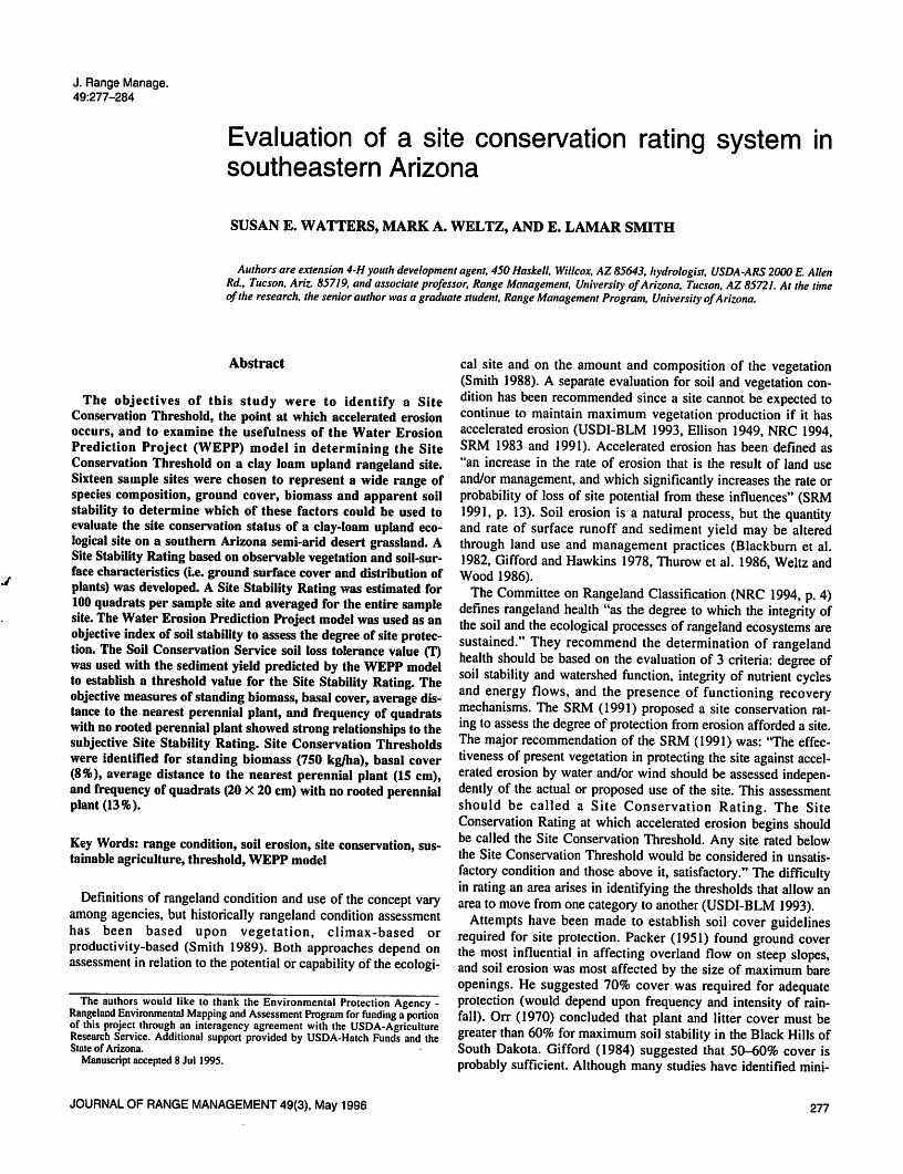
A Site Stability Rating was estimated for each nested quadraton a scale of 1 to 5 (Fig. 1) as an integer. The Site StabilityRating is a subjective rating procedure developed to determine ifquadrats could be used to quantify the mean stability within asample site. The Site Stability Rating descriptions were adaptedfrom the Region 3 Range Analysis Forest Service Handbook(USDA-U.S. Forest Service 1970). They were based on theamount and patchinessof ground cover, and evidence of past soilmovement. An average Site Stability Rating for the sample sitewas determined from each quadrat size.
Sediment yield was predicted for each sample site using theWEPP single event model (Version 93.3)(Laflen et al. 1991) withthe vegetation parameters of distance to nearest perennial plant(m), percent rock and litter cover, and standing biomass (kg/m2).The WEPP model partitions soil erosion into rill and interrill erosion. Interrill erosion is a function of raindrop splash detachment.The amount of soil erosion from splash detachment is a functionof rainfall intensity and amount of bare ground (Lane andNearing 1989). Rill erosion is a function of velocity of the waterand the sediment concentration within the water. Rilling and/ordetachment of soil particles by concentrated flow is a function ofthe hydraulic shear force of the water. The hydraulic shear of theflowing water is inversely proportional to the hydraulic roughness of the surface and velocity of the water. Hydraulic roughnesson rangelands within the WEPP model are estimated as a function of rock, litter, basal cover, standing biomass, random roughness, and soil texture (Weltz et al. 1992).
It was hypothesized that the storm intensity required to initiaterilling (a threshold increase in erosion rate) might be a way toidentify the Site Conservation Threshold for rangelands. Thosethat rilled with a 10-year storm or less would be below the SiteConservation Threshold, those that rilled with a 25-year stormmight be borderline, and those that rilled only with a 50-yearstorm or greater would be above the Site Conservation Threshold.The six-hour rainfall event with return frequencies of 5, 10, 25,50, and 100 years were used to estimate the effects of storm sizeon predicted soil erosion.
The hypothesized relationship of the six-hour, 10, 25, and 50-year return frequencies storms to the health of rangeland ecosys-
JOURNAL OF RANGE MANAGEMENT 49(3), May 1996

Fig. 1.Sample SHe StabilityRatingsfor a clay loam upland rangeland site in the winter. 1)Plant coverand litter sparse, patchy, and definitely not effective in preventing soil movement. Bare spaces frequent, commonly coalesced with a definite runoff pattern; large bare spacescommon. Erosion pavement may be well developed in bare spaces. Soil movement prominent. Majority of plants pedestaled. 2)Intermediate between 1and 3. 3) Plant coverand litter thin or discontinuous and not well distributed. Barespaces oftencoalescing but withno continuous runoff pattern, large spaces less common than small ones. Soil movement discernible on less than half the area. OccasionalPedestaling and close to barespaces. 4) Intermediate between 3 and 5.5) Plant cover and litter well distributed; appears effective in protecting the soil. Bare spaces small, well dispersed, occasionally coalescing. No erosion pavement. Soil movement none or very slight andpatchy. Pedestaling rare and close to bare spaces.
tems were selected based on the following criteria. The selectionof event duration (6-hours) was chosen to reflect the dominanceof summer convective thunderstorms on soil erosion in the south
west in contrast to longer duration and lower intensity winterfrontal storms (Renard et al. 1993). The return frequencies of 10,25, and 50-years were chosen to reflect the interaction of soilproperties, land-use, and soil erosion. Based on work by Osborn(1984), Osborn and Goodrich (1993), and Renard et al. (1993) itwas hypothesized that return frequencies of the 2 and 5-yearevent would often not generate sufficient overland flow to initiaterilling for many upland rangeland soils. The selection of the 10,25, and 50-year return frequencies was based on the assumptionthat, at these rates, changes in land-use or management practicescould alter the vegetation and surface soil conditions enough toinfluence protection from rilling. The 100-year return event wasnot selected because for most arid and semi-arid ecosystemssevere erosion will naturally occur because of lack of adequateprecipitation to produce vegetation to protect the soil surfacefrom these episodic events (Branson et al. 1981).
Total rainfall depth (mm) for the six-hour, 5, 10, 25, 50, and100-year return frequency storms were 43, 60, 76, 89, and 108,respectively. Maximum peak 10 min. rainfall intensity (mm/hi)for the six-hour, 5, 10, 25, 50, and 100-year return frequencystorms were 45, 75, 106, 137, and 199, respectively. Soil characteristics, initial soil moisture, and slope variables were constantforall sample sites. Soil parameters of bulk density (g cm"3), soiltexture [sand and clay (%)], and organic matter (%), were parameterized from data supplied by the Soil Conservation Service(Hendricks 1985). The erosion (interrill erodibility, rill erodibili-ty, and critical shear stress) and hydrologic (effective hydraulicconductivity) parameters were estimated with the default equa
JOURNAL OF RANGE MANAGEMENT 49(3), May 1996
tions of the WEPP model (Lane and Nearing 1989). Soil moisturewas initialized at 90% of saturation. Model outputs of interestwere runoff volume (mm) and sediment yield (ton/ha). The 25-year storm event was used for further analysis because of itshypothesized "currently functioning-but at risk to degradation"relationship to site stability.
The WEPP model is highly sensitive to changes in litter coverand standing biomass (Tiscareno-Lopez et al. 1993). The minimum expected vegetation and rock cover (%) should be used todefine the Site Conservation Threshold for long term sustainabili-ty of the site. This conservative approach may result in some sitessubstantially exceeding the minimum canopy and ground coverneeded to prevent soil erosion during years with above averagegrowing season precipitation.
To evaluate the sensitivity of predicted erosion to plant density,three sample sites (2, 5, and 9) were used. All other WEPP modelparameter values for the 25-year storm event were held constant.These three sample sites were chosen because they represent thespectrum of diversity within the rangeland site of sediment yield;highly susceptible (5), moderately susceptible (9), and slightlysusceptible (2). Sediment yield was predicted while varying distance between plants from 0.04 m to 100 m. Correlation coefficients (P<0.95) were used to demonstrate the interrelationshipsbetween ground cover, standing biomass, and distance to thenearest perennial plant (Cochran 1977). Non-linear regressiontechniques were employed to determine if a threshold of site stability could be determined based on estimated sediment yieldfrom the WEPP model. The relationship of the Site StabilityRating and estimated sediment yield for the site was examinedusing non-linear regression techniques. The independent variables measured for use in linear and non-linear regression analy-
279

ses were: percent ground cover (basal vegetation, litter, rock, andbare ground), standing biomass, distance to the nearest perennialplant, and frequency ofquadrats having no rooted perennial plant.Estimated sediment yield and the Site Stability Rating were usedas dependent variables.
Results
The predicted sediment yield varied considerably among sample sites when the vegetation data collected during the winter of1991 were used (Fig. 2a). As storm intensity increased, runoff,peak discharge, and sediment yield increased (Figs. 2 and 3).There was a sharp increase in predicted erosion rates when rillingwas initiated by the WEPP model. Five sample sites initiatedrilling with the 10-year storm intensity, 8 sample sites startedrilling at the 25-year storm intensity, 2 rilled with the 100-yearstorm, and one did not rill at the 100-year, 6-hour storm event.Simanton etal. (1991) reported that rilled plots produced approximately 3.3-3.4 times the average erosion rates as comparablysloped nonrilledrangelandareas.
When vegetation data (biomass, litter, and rock) collected during the summer of 1992 were used to parameterize the WEPPmodel, the results were substantially different from thoseobtained with the winter data from 1991 (Fig. 2b). Rilling did not
80
70
60
e. 50-
40
30
20-
10
80
70
60
E. 50-
40-
30
03 20a.a.
s 10
J
c 10 year rainfall event• 25 year rainfall eventc 50 year rainfall event* Indicates minimum size rainfall
event needed to initiate rilling
d£Ld£19 15 11 16 1 4 10 6 12 7 13 8 3 14 2
Sample sites with winter vegetation cover
^B- .^n. -JL
• 10 year rainfall event• 25 year rainfall eventE 50 year rainfall event* Indicates minimum size rainfall
event needed to initiate rilling
-^-wv -^1 -H rrTI
5 9 15 11 16 1 4 10 6 12 7 13 8 3 14 2
Sample sites with summer vegetation cover
Fig. 2. WEPP model predicted sediment yield (ton ha'1) for the winter sampling (2a) and the summer sampling (2b). Sample sites arearrayed in order of decreasing winter erosion for the 25-yearstorm event
280
occur with a 10-year storm for any sample site, only one samplesite rilled with a 25-year storm and 2 with a 50-year storm. Thereduction in type and amountof soil erosionwas attributed to thechange in biotic characteristics ofthe site. The principal changesbetween the 2 sampling periods were the increases in litter andstanding biomass, because of the time of year and doubling ofrainfall during the summer 1992 growing season as compared tothe winter of 1991 (Table 1).
No significant differences were found inbasal vegetation coverbetween winter and summer except onsample site 12, which waspredominately curly mesquite. Themajor land surface characteristic that changed between the winter and summer sampling werelitter biomass, standing biomass, and bare ground. Litter increases ranged from 4 to 243%, standing biomass increases rangedfrom 8 to 107%, and bare ground decreases ranged from 0 to137%. The wintervegetation and coverdata wereusedfor furtheranalysis and interpretation, since they represented the minimumground cover and standing biomass evaluated during the study.
The subjective Site Stability Rating was highly correlated tobasal cover (r = 0.91), litter cover (r = 0.79), and standing biomass (r = 0.94). The high correlation between cover, litter, andstanding biomass and Site Stability Rating was expected as theyare used todefine the different classes inthe Site Stability Rating.There was a significant relationship between the Site StabilityRating and the sediment yield predicated by the WEPP model.
250
200
ISO
100
50
0
10-year
25-year50-year
3a
5 9 15 11 16 1 4 10 6 12 7 13 8 3 14 2
5 9 15 11 16 1 4 10 6 12 7 13 8 3 14 2
Samplesiteswithwinter vegetation
Fig. 3. WEPPmodel predicted rainfall intensity (mm hr"1) (3a), peakrunoff rate (mm hr'1) (3b), and total runoff volume (mm) (3c) forsample sites with winter vegetation.
JOURNAL OF RANGE MANAGEMENT 49(3), May 1996

Table 1. Vegetation characteristics for winter 1991 and summer 1992 sampling periods, ordered from least to most stable, based on the Site StabUityRating. J
Freq. of quadrats Distance toSample Basal Standing with no rooted nearest per.Site vep. Litter Rock Ba£g_pnr>nnft plant
1992
plant
1991No. 1991 1992 1991 1992 1991 1992 1991 1992 1991 1992 1991
(kg/ha) (%) (m)5 3 5 8* 28 17 23 72* 46 258 536 42 49 0.249 3 2 9* 23 48 42 40 33 507 650 83 72 0.8611 4 3 10* 32 32 35 54* 31 580 599 56 59 0.3610 4 7 8* 19 51 56 37* 19 458 867 37 23 0.257 7 10 16 25 22 24 55* 41 653 1,116 14 22 0.1414 3 4 16 18 33 36 48 42 605 657 54 55 0.381 7 10 13* 24 23* 35 57* 32 595 746 35 34 0.24IS 7 12 13 17 20* 11 60 61 731 880 21 18 0.1716 6 9 10* 21 34* 23 50 48 653 848 19 19 0.168 7 11 21 22 20 20 52 48 639 1,020 22 23 0.156 12 14 19* 36 5 4 64* 46 999 1.186 2 7 0.094 17 23 5* 16 47 41 31* 20 722 822 0 0 0.0513 7 12 10* 28 51 47 32* 14 751 937 12 2 0.133 13 19 23* 35 15 12 49* 35 1,155 1,390 2 3 0.0812 14* 26 18* 36 10* 3 58* 35 839 1,167 0 0 0.052 24 24 47 53 8 7 21 17 1,575 2,512 5 3 0.09
Quadrat size had little effect onthe average Site Stability Ratingsfor a sample site and the average Site Stability Ratings for thethree quadrat sizes (10 X 10, 20 X 20, and 40 X 40 cm) werehighly correlated (r>0.93). Due to the lack of Site StabilityRating difference between quadrat sizes, results for the 20 X 20cm quadrat size only will be presented.
A threshold in accelerated erosion rates occurred in the WEPPmodel when distance between plants exceeded 0.34 m for samplesites 5 and 9 (Fig. 4). Distance to nearest perennial plant did notaffect rill formation regardless of canopy and ground cover oncedistance between plants exceeded 5 m.The large quantity of litterand standing biomass on sample site 2 resulted in the appliedhydraulic shear force being less than the critical shear force necessary to initiate rilling. Therefore, this site was stable for all distances evaluated. Ground surface cover was notsufficient to preventhydraulic shear force from exceeding critical shear force forsample sites 5 and 9 and rilling was initiated. The number andwidth ofrills across the landscape was in part a function of plantdensity.
The non-linear regression analysis demonstrates an exponentialincrease in predicted sediment yield as the Site Stability Ratingdecreases (Fig. 5). Inan effort to establish some objective meansofdetermining athreshold value for the Site Stability Rating, soilloss tolerance factors (T-values) were used. The T-values are currently estimated to vary from 4,500 kg/ha/yr (1 ton/acre/yr) onvery shallow soils to 11,200 kg/ha/yr (5 ton/acre/year) on deepsoils (USDA-SCS 1992). The Whitehouse soil found on theclay-loam upland rangeland site has aT-value of 11,200 kg/ha/yr(USDA-SCS 1976). The threshold value for this site (2.5) wasfound by solving the fitted relationship (Fig. 5) between estimated sediment yield and Site Stability Rating for a T-value of11,200kg/ha/yr. For other sites with either a different T-value orbiotic conditions thethreshold value could change. More researchwill need to be conducted in other climatic and biotic regions to
JOURNAL OF RANGE MANAGEMENT 49(3). May 1996
establish the range of threshold values and its applicability forthese areas.
The percent of exposed bare soil was poorly correlated to SiteStability Rating (r2 =0.31). Standing biomass, basal vegetationcover, distance to the nearest perennial plant, and frequency ofquadrats with norooted perennial plant showed thehighest correlations to the Site Stability Rating (Fig. 6). Standing biomassexplained the most variation in the Site Stability Rating of the 4vegetation attributes evaluated. Standing biomass during the winter was significantly correlated to the Site Stability Rating (r2 =0.87) (Fig. 6a). The threshold Site Stability Rating of 2.5 corresponds to 750 kg/ha of standing biomass, indicating that samplesites having less biomass are below the Site ConservationThreshold. Basal vegetation cover was significantly correlated tothe Site Stability Rating (r2 = 0.78). A basal cover value of 8%corresponds to the threshold Site Stability Rating of 2.5 (Fig. 6b).
Distance to the nearest perennial plant (Fig. 6c) was negativelycorrelated with the Site Stability Rating. As distance betweenplants increased the Site Stability Rating decreased. The thresholdSite Stability Rating of 2.5 corresponded to a distance to thenearest perennial plant of 15 cm (r2 = 0.62). The threshold valuefor distance to the nearest perennial plant (15 cm)was below thatindicated bythe sensitivity analysis (34 cm). The co-dependencebetween biotic variables and the wayWEPP calculates rill density isone reason for the difference. We found, with observed data,that as distance to thenearest perennial plant increased there wasapositive correlation withincreasing rock cover (r2 =0.50) and asignificant negative correlation with standing biomass and basalcover (r2 =0.90 and 0.81, respectively). The WEPP model cannotcurrently use these types of co-dependent relationships. WEPPcalculates the number of potential rills (concentrated flow paths)based onthe distance between plants. The calculation of potentialrill density is independent of standing biomass, basal cover, andother biotic and abiotic factors.
281

80
70 -
50 -
30 -
20 -
Sample site 2
Sample site 5
Sample site 9—3-
/
VB-"
- RillingInitiated
^w*^.—.^
S
/
• rating Initiated
i i ! i 1 i s i—
0.04 0.08 0.17 0.34 0.68 1.25 23 8 10 100
Average distance to nearest perennialplants (m)
Fig.4. WEPP model sensitivity to the average distance to the nearestperennial plant (m).
The frequency of quadrats that had no rooted perennial plantwas highly correlated with distance to nearest plant, and thusmight be employed as an objective surrogate measure for plantspacing in the field. The frequency of barequadrats (20 X 20 cm)was negatively correlated with the Site Stability Rating (r2 =0.58) (Fig. 6d). The threshold Site Stability Rating (2.5) correspondsto a 13% frequency of quadrats having no perennial plantrooted within them. Frequency of bare quadrats(40 X 40 cm) didnot show agood relationship (high r2) tothe Site Stability Rating.This was caused by a significant number of 0 values for the frequency of quadrats with no rooted perennial plant. The techniqueof estimating frequency with no rooted perennial plant had thesmallest coefficient of determination of the biotic variables evalu
ated. The frequency technique does have some advantages overestimating standing biomass, basal cover, and distance betweenperennial plants. The relationship of frequency with no rootedperennial plants within the 20 X 20 cm quadrats to Site StabilityRating was consistent with both the winter and summer data andthe frequency technique requires less time and expertise to estimate.
Discussion
The focus of this work was to develop the methodology andtechniques necessary to define the limits (Site ConservationThreshold) between the categories of satisfactory and unsatisfactory rangelands. The basic concept behind the Site ConservationThreshold is the development of stable indicators) for predictionof sustainable agricultural practices. The WEPP model is capableof providing a non-subjective, repeatable, method of estimatingsediment yield that can be used to evaluate differences betweenmanagement practicesor land units to establish which are potentially sustainable.
282
30 -
20-
10 -
Number equals sample site
y »251.920 X"3'4r2«059
Threshold (T-vsIud)
03 1.8 2 23 3 33
SBeStaMRy Rating
Fig. 5. A threshold relationship betweenthe WEPP model predictedsediment yield (ton ha'1) and the Site Stability Ratings.
A limitation with this study is the lack of observed precipitation, runoff, and sediment yield data to evaluate the models predicted sediment yield relationshipsto the abiotic and biotic conditions evaluated here. However, the WEPP model has been evaluated for numerous rangeland situations in southern Arizona onthe USDA-ARS Walnut Gulch Experimental Watershed nearTombstone, Ariz. The model hasbeen shown to give goodresultsin predicting runoff volume and peakdischarge in the southwest.Stone et al. (1992) evaluated the hydrologic component of theWEPP model for a semi-arid desert shrub area on the WalnutGulch Experimental Watershed and concluded that the model dida good job in fitting observed and predicted runoff volume andpeak discharge (r2 =0.91). Tiscareno-Lopez (1994) evaluated themodel on a semi-arid desert grassland watershed (1.3 ha) withsimilar vegetation, soil,andslopecharacteristics as this study andconcluded that the model could accurately predict runoff volumeand peakdischarge. Data from the USDA WEPP rangeland fieldexperiments (see Simanton et al. 1991) were used to test themodel's ability to predict sediment yield at 16 locations in thewestern United States (Kidwell 1994). Kidwell (1994), workingon a different semi-arid grassland area within the Walnut Gulchwatershed, reported that for an area with similar soilsand vegetation as this study, that the WEPP model predicted runoff volumeand peak discharge were within 2% of the observed data and thatpredicted sediment yield was within 16% of observed sedimentyield. They all concluded that the WEPP model was capable ofreliably predicting runoff and sediment yield when appropriatelyparameterized.
Further research will need to focus on the numberof replicates,size of area, andtopographic position of the area being evaluatedto fully develop the Site Conservation Threshold concept forrangelands. Dunne et al. (1993) reported that on long hillslopesthe downslope increase in flow depth in concentrated flow channels progressively inundates more permeable vegetated coppice
JOURNAL OF RANGE MANAGEMENT 49(3), May 1996

500 1,000 1300 2,000
StandingBiomass (kg/ha)
0 10 2030405060706090100
Distance (em) to Neatest PerennialPlant
y0.33
-1.26X6b
r2 -0.78 ••A
« ^r aA
/a
|[ Threshold (T-va!ue( 5tarVha/yr)!
s
t. . , .S 10 18 20 25
BasalCover (ft)
30
0 10 20 30 40 50 60 70 80 90100
Frequency ct Ouadrats withNo Rooted Perennial Ptoits
Fig. 6. Threshold relationships between Site Stability Ratings andwinter vegetation biological characteristics of 5a) standing biomass, 5b) basal cover, 5c) distance to the nearest perennial plant,and 5d) frequency of quadrats with no rooted perennialplant
dunesso that hydraulicconductivity of a greater proportion of thesurface is raised to its saturated value. This results in increasedflow velocity and potential increases in sediment detachmentthrough the rilling process in the downslope direction. Lane et al.(1995) reported that varying slope length and steepness, as wellas canopy and ground cover in the downslope direction can significantly alter the sediment deposition rate and thus sedimentyield on rangelands. They concluded that incorporating spatiallyvarying canopy and ground cover in the downslope direction inestimating erosion is mandatory if gross distortions in sedimentyield are to be avoided.
One advantage of using the WEPP model to calculate theapparent sediment yield from a hillslope is its ability to accountfor variable soil andcoverconditions in the downslope as well asacross the slope directions. This allows for identification of areasalong the hillslope that are actively eroding in excess of the SiteConservation Threshold that would not be detectable if other erosion prediction technologywere used. A secondadvantage of theWEPP model is in eliminating the subjectivity involved in locating sample sites on the hillslope to account for spatially varyingsurface conditions. The WEPP model can estimate soil loss from
the entirehillslope.This eliminates the requirement of developingmethods to account for varyingsoil loss alongthe hillslope. Slope
JOURNALOF RANGE MANAGEMENT 49(3), May 1996
length limits for applicability for the Site Conservation Thresholdhave not been precisely defined. The minimum length of area tobe considered is approximately from the origin of overland flowto concentration of flow in a well defined channel.The preferredsolution wouldbe fromthe ridgetop to the end of the hillslope.
Site Conservation Thresholds were found for standing biomass(750kg/ha), basal cover (8%), average distance between perennial plants (15 cm), and frequency of quadrats with no rootedperennial plant(13%) for a semi-ariddesertgrassland in SouthernArizona. Estimated basal cover was the best single indicator ofsite stability of those evaluated in this study. Basal cover variedwith season and weather conditions, but was much less sensitiveto these short term seasonal climatic variation and grazing pressure thanwas standing biomass or litter. Standing biomass at anydate within a year is highly dependent on effective precipitationwithin the growing season, current weather conditions, relationship to livestock grazing cycles and stocking rates, and thedecomposition of biomass. The amplitude in standing and litterbiomass over time due to climateand landmanagement practiceswill result in significant changes in estimated sediment yield.Therefore, the site will alternate above and below the SiteConservation Thresholdbasedsolely on sampling date.
A conservative approach is to sample when the least amount ofvegetation is expected prior to the time of highest probability ofintense thunderstorm activity. The critical time in southernArizona for sampling is in early June prior to the onset of themonsoon season in July and August. If the site is stable with noindication of accelerated erosion under these conditions, then thesoilresources will be retained and a sustainable ecosystem shouldbe achieved. Measurements would need to be site specific. Thesame thresholds cannotbe applied to all ecological sites becauseof the complex interactions that occur.
The Site Conservation Rating technique is not intended toreplace the WEPP model for estimating soil erosion on range-lands. However, the data required to parameterize the WEPPmodel are considerable and costly to collect. The SiteConservation Rating method is being proposed for rapid assessment or inventory of rangelands. If the Site Conservation Ratingfor a pasture, landscape or watershed is below the threshold thena detailed assessment of the area should be performed to determine if the site is actually below the threshold with the WEPPmodel. The WEPP model can be used to evaluate alternativemanagement scenarios (change in seasonof use, stocking rate, orkind of animal, etc.) to determine whichhavethe highest potential forpreventing future degradation andorrecovery of the site.
Literature Cited
Blackburn, W.H., R.W. Knight, and M.K. Wood. 1982. Impact ofgrazing on watersheds: A stateof knowledge. Texas Agr. Exp.Sta.MP1496.College Station,Tex. 32 pp.
Bonham, CD. 1989. Measurements for terrestrial vegetation. JohnWiley & Sons. N.Y.
Branson, F.A., G.F. Gifford, K.G. Renard. R.F. Hadley. 1981.Rangeland hydrology. Rangeland Science Series 2nd Edition, Societyfor Range Management, Denver, Colo.Kendall/Hunt Publishing.
Cochran,W.G. 1977.Sampling techniques. John Wiley & Sons. N.Y.Costin, A.B. 1980. Runoff and soil and nutrient losses from improved
pasture Ginninderra, Southern Tablelands. New South Wales.Australian J. Agr. Res. 31:533-546.
Costin, A.B., DJ. Wimbush, and R.N. Cromer. 1960. Studies in catchment hydrology in the Australian Alphs II surface runoff and soil loss.CSIRO Division of Plant Industry, Tech. Paper No. 14.
283

Dunne,T., W. Zhang, and R. F. Aubry. 1993.Effectsof rainfall, vegetation, and microtopography on infiltration and runoff. Water Res. Res.27:2271-2285.
Ellison, L. 1949. The ecologicalbasis forjudging conditionand trend onmountain range land. J. Forestry 47(10):786-795.
Gifford, G. F. 1984.Vegetation allocation for meeting site requirements,pp. 35-116. In: NAS/NRC. Developing Strategies for RangelandManagement Westview Press.
Gifford, G.F. and R.H. Hawkins. 1978. Hydrologic impact of grazingon infiltration:A critical review. Water Resource Res. 14(2):305-313.
Haydock, K.P., and N.H. Shaw. 1975. The comparative yield methodfor estimating the dry matter yield of pasture. Australian J. of Exp.Agr. Animal Husb. 15:663-670.
Hendricks, D. M. 1985. Arizona soils. Univ. of Arizona Press.Kearney, T. H. and R. H. Peebles. 1951. Arizona Flora. Univ. of
California Press, Berkley.Kidwell, Mary R. 1994. Distribution of groundcover and its effect on
runoff and sediment yield in the WEPP model. M.S. Thesis, TheUniversity of Arizona, Tucson.
Laflen,J.M., LJ. Lane,and G.R. Foster. 1991. WEPP: A new generation of erosion prediction technology.J. Soil Water Cons. 46:30-34.
Lane, L. J., M. H. Nichols,and J. R. Simanton. 1995.Spatial variability of cover affecting erosion and sediment yield in overlandflow. In:Effects of scale on interpretation and management of sediment andwater qualilty. International Association. Hydrological Sciences, (inPress).
Lane, LJ. and M.A. Nearing (editors). 1989. USDA—water erosionprediction project: hillslope profile model documentation. NSERLReport No.2. W. Lafayette, Indiana.
Lang, R.D. 1979. The effect of ground cover on surface runoff and soilloss from experiments plots. J. Soil Conserv. Service of New SouthWales. 35:108-114.
Marston, R.B. 1952. General cover requirements for summer stormrunoff control on Aspen sites in Northern Utah. J. Forestry.50:303-307
Moore, T.R., D.B Thomas, and R.G. Barber. 1979. The influence ofgrass cover on runoff and soil erosion from soils in the Machakos area,Kenya. Tropical Agr. 50:339-334.
NOAA (National Oceanic and Atmospheric Administration). 1991.Climatological Data Annual Summary, Arizona. Vol 95, No. 13.
Noble, EX. 1965. Sediment reduction through watershed rehabilitation.Misc. Publ. 970, U.S.D.A., 114-123.
NRC (National Research Council), Committee on RangelandClassification. 1994. Rangeland health: new methods to classify,inventory and monitor rangelands. National Academy Press,Washington, D.C.
Orr, ELK. 1970. Runoff and erosion control by seeded and native vegetation on a forest burn: Black Hills, South Dakota. USFS Res. PaperRM-60.12 pages.
Osborn, H. B. 1984. Storm-cell properties influencing runoff from smallwatersheds. Trans. Res. Record. 922:24-32.
Osborn, H. B. and D. C. Goodrich. 1993. Characterization of thunderstorm rainfall for hydrologic modeling. Pgs. 409-415. In: Managementof Irrigation and Drainage Systems. ASCE.
Packer, P.E. 1951. An approach to watershed protection criteria. J.Forestry 49:635-644.
Renard, K.G., L. J. Lane, J. R. Simanton, W. E. Emmerich, J. J.Stone, M. A. Weltz, D. C. Goodrich, and D. S. Yakowitz. 1993.Agricultural impacts in an arid environment: Walnut Gulch studies.Hydrological Science and Technology. 9:145-190.
Simanton, J. R., M. A. Weltz, and H. D. Larsen. 1991. Rangelandexperiments to parameterize the water erosion prediction projectmodel: vegetation canopy cover effects. J. Range Manage. 44:276-282.
Smith, E. L. 1988. Successional concepts in relation to range conditionassessment. In: Vegetation science applications for rangeland analysisand management, Tueller, P.T. (ed). Kluwer Academic Publishers.
284
Smith, E. L. 1989. Monitoring concepts for rangelands. p. 210-220. In:Volume 1: Conference Proceedings of the Global Natural ResourceMonitoring and Assessments: Preparing for the 21st Century.September, 1989.Venice. Italy.
SRM (Society of Range Management), Range InventoryStandardization Committee. 1983.Guidelines and terminology forrangeinventories and monitoring. Soc. RangeManage.Denver,Colo.
SRM (Society of Range Management), Task Group on Unity inConceptsand Terminology. 1991. Newdirection in range conditionassessment: Report to SRM Board of Directors. Soc. Range Manage.Denver, Colo.
Stone, J. J., L. J. Lane, and E. D. Shirley. 1992. Infiltrationand runoffsimulationon a plane. Trans. Am. Soc. Agric. Eng. 35:161-170.
Thurow, T.L., W.H. Blackburn, and C.A. Taylor, Jr. 1986.Hydrologic characteristics of vegetation types as affected by livestockgrazing systems, Edwards Plateau, Texas. J. Range Manage.39:505-509.
Tiscareno-Lopez, M., V.L. Lopes, JJ. Stone, and LJ. Lane. 1993.Sensitivity Analysis of the WEPP Watershed Model for RangelandApplications I: Hillslope processess. Trans. Amer. Soc. Agr. Eng. 36:1659-1672.
Tiscareno-Lopez, M. 1994.A bayesian-monte carlo approach to assessuncertainties in processed-based continuous simulation models. Ph.D.Thesis., The University of Arizona, Tucson.
t'MannetjeX. and K.P. Haydock. 1963. The dry-weight rank methodfor the botanical analysis of pasture. J. British Grassl. Soc. 18:268-275.
USDA-SCS. 1976. Soil Loss Equation.Conservation Planning Note No.11 - Arizona. Phoenix, Ariz.
USDA-SCS. 1988. Clay loam upland 12-16PZ range site description.Arizona Field Office.
USDA-SCS. 1992. National Soil Survey Interpretations Handbook.Washington D.C.
USDA-U.S. Forest Service. 1970. Range Environmental AnalysisHandbook, Southwestern Region. 34.52,1-3.
USDI-BLM. 1993. Riparian area management. Tech. Rep. 1737-9.Denver, Colo.
Weltz, M.A. and M.K. Wood. 1986. Short duration grazing in CentralNew Mexico: Effect on sediment production. J. Soil and WaterConserv. 41:262-266.
Weltz, M. A., A. B. Arslan, and L. J. Lane. 1992. Hydraulicroughnesscoefficients for native rangelands. J. Irrig. and Drainage Eng.118(5):776-790.
JOURNAL OF RANGE MANAGEMENT 49(3), May 1996