jaftools – v8 - johnfrancis.co.zajohnfrancis.co.za/data/documents/userguide-jaftools.pdf ·...
TRANSCRIPT

JAFTools – V8
User Guide
Version 8.24 October 2012
“ My philosophy is to provide tools to people so that their work becomes
more streamlined and efficient, thus enabling them to reach higher levels
of standardisation and control. In this process, they are empowered to be
completely independent and familiar with their working environment,
ultimately resulting in the saving of man-hours. This is achieved by
enhancing their knowledge with specific, targeted training, and the
efficient use of customised tools, which they themselves have been
involved in developing. ’’ - JAF

Page 1
Jaftools User Guide : Page 1
TABLE OF CONTENTS
PART I INTRODUCTION
Private Files
Changes to System Configuration
Licensing
Example Data/Files
Obtaining a Licence to use JafTools
4
PART Ia INSTALLATION 6
PART II USING JAFTOOLS 7
PART III CUSTOMISED UTILITIES 8
III.1 DRAWING
III.1.a Map Cells Place standard mapping symbols DipTank
Grave
Hut
Tower
Manhole
Pole
Reservoir
North
TelPole
Tree
Trig
Well
Windmill
Water Main
Eskom Logo
9
III.1.b Map Areas Define and fill areas with standard mapping symbols Lands
IrLands
Trees
ConifTr
Marsh
Rocky
Orchard
IrrOrch
Plantn
Bush
10

Page 2
Jaftools User Guide : Page 2
III.1 DRAWING (Cont.)
III.1.c Map Linear Place standard linear features Tel Line
Tel Cable
Pipeline
UG Cable
Camp Fence
Sec Fence
Farm Bdy
SubDv Bdy
Wall
Powline
D/C Pline
11
III.1.d Map Curves Place standard curve-type features Track
Road
Donga
Embank
Edge Bush
Line Trees
Line Conif
Foot Path
Rail Line
Terrace
12
III.2 NATIONAL STANDARDS
Summary
13
III.2.a Automated Span Lengths and Pole Placement Automated Placing of Span Lengths and Poles
14
Page 3
Jaftools User Guide : Page 3
III.3 SURVEY 15
III.3.a ReadYXZ Import YXZ Co-ordinates From ASCII or Text File
16
III.3.b Lo-Grid Create YX Grid Lines
19
III.3.c CadCodes Create and Place Rural Structure Codes
21
III.3.d Ext-WGS84(DMS) Extracts WGS84 Datum Geographical Co-ordinates to ASCII file
23
III.3.e Eliminate Eliminates Duplicate Text items within a specified radius
24
III.3.f ColmPlot Imports Geographical ASCII data
25
III.3.g Imp-YXZ Import YXZ Co-ordinates From ASCII or Text File
(As per original SE/95 Version)
26
III.3.h Exp-NYXZ Exports Text Items’ Co-ordinates to ASCII file
29
III.3.i Exp-Extras Exports Text Items’ Co-ordinates to ASCII file in various formats
31
III.4 INFO 32
III.4.a Restore Default Cell Library Restores necessary JafTools Cell Libraries
32
III.4.b License Info Displays your current License Information
32
III.4.c About JafTools Highlights a couple of tips to avoid problems when using
JafTools
33
III.4.d JafTools User-Guide Display the JafTools User Guide (PDF Doc)
33
PART IV THIRD PARTY APPLICATIONS 34
IV.1 ScRotTC Scale and Rotate Text and Cells
34
Any reference to ‘uCheetah’ also refers to ‘JafTools’. uCheetah is the newer version
available for MicroStation Ver 8i.
Page 4
Jaftools User Guide : Page 4
PART I INTRODUCTION
JafTools is a set of utilities, mainly customised for the Eskom Survey Drawing Office
environment.
All routines are written using MDL (MicroStation Development Language),
MicroStation User-Commands and some minor routines with Microsoft Visual C++.
Private Files.
JafTools uses two cell libraries exclusively:- c:\JafTools-V8\JafTools.cel and
urbanrural.cel. It is recommended that the user does not add new cells to these
libraries, as they will be lost whenever JafTools is updated or re-installed. If cells are
not placed correctly via the routines, then the default cell libraries can be restored via
the “Info” menu option.
The main aim of developing JafTools, is to reduce the number of man-hours spent on
drawing tasks. Users are encouraged to put forward any proposals that support this
aim. Most repetitive tasks can be automated, which saves man-hours and reduces
boredom.
Changes to System Configuration.
JafTools files must reside on the C:\> drive: in the ‘JafTools-V8’ folder:
Viz: C:\JafTools-V8\
JafTools does not modify the computer system in any way, and neither does it make
any changes to the MicroStation User Preferences.
JafTools does not put hidden ‘marks’ in design files, nor attach hidden identification
to any design file elements.
Licensing.
User licence data is hard-coded into the software, and will expire after a specified
period, if no maintenance agreement is in place.
Example Data/Files.
Some sections of this manual refer to example data, supplied for testing, or better
understanding of the usage of any particular routine. All example data will be located
in the directory ‘C:\JafTools-V8\Examples\’
Obtaining a Licence to use JafTools.
In order to be able to use JafTools, a licensed version of the software will be created
for you. In order to obtain the licence, first complete the Data Request Form available
as “JafToolsData.exe”. This can be forwarded to you via email, or is in the
c:\JafTools-V8\RequestForm\ folder. It is also available via download from
www.johnfrancis.co.za/DataConversion.html.
Page 5
Jaftools User Guide : Page 5
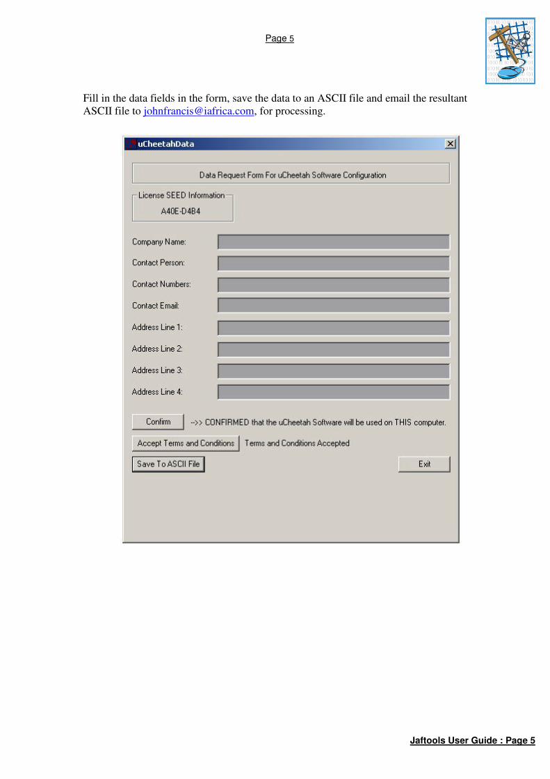
Fill in the data fields in the form, save the data to an ASCII file and email the resultant
ASCII file to [email protected], for processing.
Page 6
Jaftools User Guide : Page 6
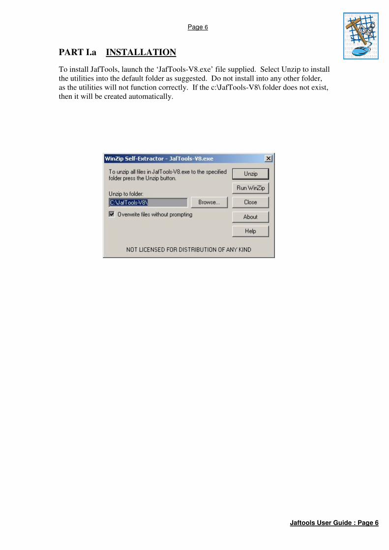
PART I.a INSTALLATION
To install JafTools, launch the ‘JafTools-V8.exe’ file supplied. Select Unzip to install
the utilities into the default folder as suggested. Do not install into any other folder,
as the utilities will not function correctly. If the c:\JafTools-V8\ folder does not exist,
then it will be created automatically.

Page 7
Jaftools User Guide : Page 7
PART II USING JafTools
Launching the application.
NOTE! JafTools will not work in “High Security” versions of MicroStation.
In the key-in window, type:- MDL LOAD JAFTOOLS
or Use the MicroStation Menus:- Utilities->MDL Applications: Select
JAFTOOLS under ‘Available Applications’, then click ‘Load’. Close the MDL
Applications Dialog Box Window. (This option MUST be used the first time the
application is used – you will need to “Browse” to c:\JafTools-V8\MdlApps\ to
find the JafTools.ma file.)
A Function Key can be assigned for the loading of JafTools;
Once the Main JafTools Dialog Box is displayed, the utilities are available via a series
of pull-down menus.
Fig. 1: Main JafTools Dialog Box
Selecting ‘Quit’ will unload JafTools, and all options loaded from ‘NationalStds’ and
‘Drawing’. Routines loaded from ‘Survey’ will remain loaded if ‘Quit’ is selected.
NOTE!
If a dialog box appears suggesting that “a configuration file is missing”, it can be
either of two things:-
1). A needed configuration file “c:\JafTools-V8\config\JafTools-V8.cfg” is
missing – you will need to contact John Francis to obtain a copy.
2). A ‘Rights’ issue needs to be resolved (only in Windows 7). All users need to
be given ‘FULL Rights’ to the folder and sub-folders in which the
MicroStation executables etc reside. The default folder is:- C:\Program Files
(x86)\Bentley\MicroStation V8 (SELECTseries)\MicroStation\ - but it may
have been installed elsewhere, at the installer’s request. The folder can be
identified by looking at the ‘MSLOCAL’ variable in
“Workspaces/Configuration” in MicroStation’s main menus. These folders
need to be ‘writable’, however when installed in Win 7, they are ‘read-only’
by default.

Page 8
Jaftools User Guide : Page 8
PART III CUSTOMISED UTILITIES
These utilities are grouped into three main categories, NationalStds, Drawing, Survey
and 3rdPtyUtils (Third Party Utilities). The NationalStds and ‘Drawing’ sections are
particularly relevant to Eskom, as they are in accordance with the Eskom Standards.
The ‘Survey’ section is more generalised. The ‘3rdPtyUtils’ are routines written by
other parties (Freeware).
III.1 DRAWING
These tools provide a means of generating mapping symbology for map features.
They are particularly useful for compiling spanning plans/detail sheets and profile
strip survey drawings. The ‘JAFTools’ dialog box must not be closed while any items
under ‘Drawing’ are open. There are four groups of routines, as follows:
Map Cells Individual map symbols, representing features that exist on the
ground, and other map information symbols.
Map Areas Filling of an area, defined by the user, with an array of symbols
representing the feature that exist on the ground.
Map Linear These routines place symbols along user-defined linear elements,
synonymous with MicroStation LINE elements.
Map Curves These routines place symbols along user-defined curve elements,
synonymous with MicroStation CURVE elements.

Page 9
Jaftools User Guide : Page 9
III.1.a Map Cells
In the JAFTools Dialog Box,
select ‘Drawing->Map Cells’.
Fig. 2: Map Cells Selection
The Map Cells Dialog Box will
be displayed, as such:
Fig. 3: MapCells Dialog Box
Click on ‘Choose’, in the MapCells dialog box to select which cell is to be
placed. The available options are:
DipTank Dipping Tank
Grave
Hut
Tower Major Line Tower Position
Manhole
Pole General Power Pole
Reservoir
North North Arrow
TelPole Telephone Pole
Tree
Trig Trig Beacon
Well
Windmill
Water Main
Eskom Logo
Select the scale that the drawing will be plotted at.
Select ‘Place Cell’.
Place the cell in the drawing, using a Data point.

Page 10
Jaftools User Guide : Page 10
III.1.b Map Areas
In the JAFTools Dialog Box,
select ‘Drawing->Map Areas’.
Fig. 4: Map Areas Selection
The Map Areas Dialog Box
will be displayed, as such:
Fig. 5: Map Areas Dialog Box
Click on ‘Feature’, in the Map Areas dialog box to select which Area Symbol
is to be used. The available options are:
Lands Cultivated Lands
IrLands Irrigated Lands
Trees
ConifTr Coniferous Trees
Marsh
Rocky Rocky Outcrop
Orchard Cultivated Orchard
IrrOrch Irrigated Orchard
Plantn Plantation
Bush
Select the scale that the drawing will be plotted.
Select ‘Draw’, then define the area, using Data points as if you were drawing a
fence.
Once the ‘fence’ is closed, the area will be filled with the Feature pattern as
selected.
Hint – If you wish the symbols in the patterned area to be ‘snappable’, then
prior to using this routine, open the ‘Patterns’ tool menu, and select
‘Snappable Pattern’ in the pattern settings dialog box. Also, always have
‘flood’ selected in the patterns dialog box prior to defining area to be
patterned.

Page 11
Jaftools User Guide : Page 11
III.1.c Map Linear
In the JAFTools Dialog Box,
select ‘Drawing->Map Linear’.
Fig. 6: Map Linear Selection
The Map Linear Dialog Box
will be displayed, as such:
Fig. 7: Map Linear Dialog Box
Click on ‘Feature’, in the Map Linear dialog box to select which Linear
Symbol is to be used. The available options are:
Tel Line Telephone Line
Tel Cable Telephone Cable
Pipeline
UG Cable Underground Cable
Camp Fence
Sec Fence Security Fence
Farm Bdy Farm Boundary
SubDiv Bdy Sub-Divisional Boundary
Wall
Powline General Power-line
D/C Pline Double Circuit Power-Line
Select the scale that the drawing will be plotted .
Select ‘Draw’.
Place a series of Data points as if you were drawing a linestring.
Once the ‘Reset’ button is pressed, the line will be patterned with the Feature
as selected.
The last two Data Points determine the orientation of the symbols on the
placed linestring. If the last Data Point is to the right of the previous one, then
the symbol orientation will be to the top of the screen. If the last Data Point is
to the left of the previous one, then the symbol orientation will be to the
bottom of the screen.
Hint – If you wish the symbols in the patterned area to be ‘snappable’, then
prior to using this routine, open the ‘Patterns’ tool menu, and select
‘Snappable Pattern’ in the pattern settings dialog box.

Page 12
Jaftools User Guide : Page 12
III.1.d Map Curves
In the JAFTools Dialog Box,
select ‘Drawing->Map Curves’.
Fig. 8: Map Curves Selection
The Map Curves Dialog Box
will be displayed, as such:
Fig. 9: Map Curves Dialog Box
Click on ‘Feature’, to select which Curve Symbol is to be used. The available
options are:
Track
Road
Donga
Embank Embankment
Edge Bush Edge of Bush
Line Trees Line of Trees
Line Conif Line of Coniferous Trees
Foot Path
Rail Line Railway Line
Terrace
Select the scale that the drawing will be plotted.
Select ‘Draw’.
Place a series of Data points as if you were drawing a curvestring.
Once the ‘Reset’ button is pressed, the curve will be patterned with the Feature
as selected.
The last two Data Points determine the orientation of the symbols on the
placed curvestring. If the last Data Point is to the right of the previous one,
then the symbol orientation will be to the top of the screen. If the last Data
Point is to the left of the previous one, then the symbol orientation will be to
the bottom of the screen.
Hint – If you wish the symbols in the patterned area to be ‘snappable’, then
prior to using this routine, open the ‘Patterns’ tool menu, and select
‘Snappable Pattern’ in the pattern settings dialog box.

Page 13
Jaftools User Guide : Page 13
III.2 NationalStds (National Standards)
These tools are used for drawing all MV and LV infrastructure, typically used in
electrification drawings. Most of the items in the menus operate in a similar manner,
with few exceptions, however, the operations are simple and self-explanatory.
It should be noted that it is good practice (when drawing lines/conductors), to use the
JafTools menus merely to ‘set up’ the line symbology, and then to use the standard
MicroStation ‘Place SmartLine’ utility, and AccuDRAW to complete the line
drawing.
Each category under NationalStds has its own dialog box, but a ‘Frequents’ menu is
also supplied, which incorporates the most commonly used items in these menus.

Page 14
Jaftools User Guide : Page 14
III.2.a Auto Span Lengths and Pole Placement
The Span Lengths Utility enables the automated placement of Span Lengths.
The choice available (MV or LV Lines), ONLY sets the TEXT settings specifically,
i.e. Level 16 for LV and Level 17 for MV. This routine does not determine whether a
line is either MV or LV, based on the line’s symbology. MV Poles will be placed if
“MV Lines” is selected, LV Poles if “LV Lines” is selected. Click in the Check-Box
for placement of poles. All lines in the fence will be processed, so switch off the
levels containing any lines which should not be processed, e.g. LV17 (eL Text Box).
The span lengths can be placed either Above or Below the line.
NOTE! The Scale setting is not linked to the general “JafTools” Scale setting, as this
is a separate routine – so be careful.
Usage: Place a Fence (any shape) around the lines for which span lengths need to be
calculated. Obviously, MV and LV must be processed separately, so turn on/off the
relevant levels as you require. For example, make the level which has the MV lines
the Active Level, and switch off all the other levels (except LV17, which is for MV
Notes/Text). Place a fence around the lines to be processed, and select “Process Span
Lengths”. Do the same for LV. Fence ‘Clip’ mode does not work with this routine.
Some fiddling, ingenuity and common sense will be required when processing
MV/LV lines on shared structures – where they are drawn parallel, in order for the
span lengths to be displayed in the correct position and with the correct value.
Poles are placed at the end of each line segment, so some cleaning up may be
required. Obviously, MV/LV combination poles will need to be placed manually, and
clearing away of the auto-placed poles on the MV-over-LV sections will need to be
carried out first.

Page 15
Jaftools User Guide : Page 15
III.3 SURVEY
These tools are MDL routines which enhance the functionality of MicroStation. They
assist the user by automating tasks which would otherwise take a long time to
complete. Once any of the options on the ‘Survey’ menu are selected, the main
‘JAFTools’ menu may be closed if desired. Included here are the following:
ReadYXZ Import YXZ Co-ordinates From ASCII or Text File
Lo-Grid Create YX Grid Lines
CadCodes Create and Place Rural Structure Codes
Ext-WGS84 Extracts Geographical C0-ords to ASCII File (Lat, Long)
Eliminate Eliminates duplicate TEXT items within a specified radius
ColmPlot Imports Geographical Co-ordinates to DGN
Imp-YXZ Import YXZ Co-ordinates From ASCII or Text File
(As per original SE/95 Version) Exp-NYXZ
Exports Text Items’ Co-ordinates to ASCII file Exp-Extras
Exports Text Items’ Co-ordinates to ASCII file in various formats
Page 16
Jaftools User Guide : Page 16
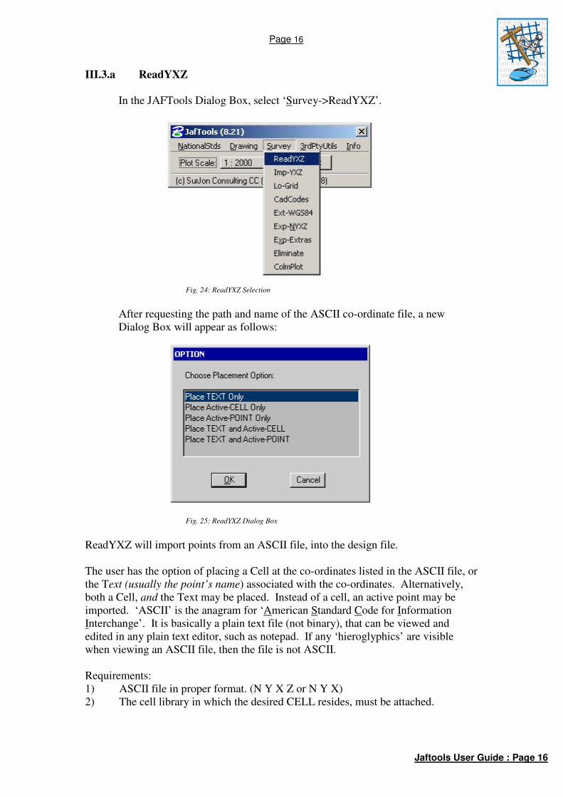
III.3.a ReadYXZ
In the JAFTools Dialog Box, select ‘Survey->ReadYXZ’.
Fig. 24: ReadYXZ Selection
After requesting the path and name of the ASCII co-ordinate file, a new
Dialog Box will appear as follows:
Fig. 25: ReadYXZ Dialog Box
ReadYXZ will import points from an ASCII file, into the design file.
The user has the option of placing a Cell at the co-ordinates listed in the ASCII file, or
the Text (usually the point’s name) associated with the co-ordinates. Alternatively,
both a Cell, and the Text may be placed. Instead of a cell, an active point may be
imported. ‘ASCII’ is the anagram for ‘American Standard Code for Information
Interchange’. It is basically a plain text file (not binary), that can be viewed and
edited in any plain text editor, such as notepad. If any ‘hieroglyphics’ are visible
when viewing an ASCII file, then the file is not ASCII.
Requirements:
1) ASCII file in proper format. (N Y X Z or N Y X)
2) The cell library in which the desired CELL resides, must be attached.

Page 17
Jaftools User Guide : Page 17
Text
This program uses the current text settings, i.e. size, justification and font.
If the text is to be plotted at any specific size for a desired scale output, then the text
size must be calculated and set prior to clicking ‘OK’.
N Y X Z (At least ONE SPACE between fields, no spaces in the Name (N))
or
PtName Y X
E.g.:
ROCK -78234.42 3218336.65 254.32
MH -78106.22 3218332.23 252.34
or
ROCK -78234.42 3218336.65
MH -78106.22 3218332.23
ASCII File rules:
There must be at least one space between the fields (columns).
There can be many spaces, but there must be at least one.
The data does not have to be in straight columns, just as long as there is at least one
space between the fields.
The spaces must not be TABS.
There must not be any spaces in the PtName (N) field. If your ASCII file has names
with spaces in, they must be replaced with underscores(_) or hyphens (-).
The decimal character must be a point, not a comma.
The Fields/Columns must not be separated by commas, only spaces.
Input Data Format
Select ‘Yes’ if the signs of the Y,X co-ordinates in the ASCII file must be changed
before plotting. I.e. The Eskom standard specifies that X co-ords must display as
negative in MicroStation. If the X Co-ord value in the ASCII file is positive, then this
box should be checked.
Ascii Format
Name Y X Z is used if PtName is the 1st Field/Column in the ASCII file.
See example file ‘NYXZ-EG.TXT’
Y X Z Name is used if PtName is the 4th
Field/Column in the ASCII file.
See example file ‘YXZN-EG.TXT’
Once all selections have been made, select ‘OK’, and the program will run, and
indicate in the MicroStation Command Window, how many points were plotted.

Page 18
Jaftools User Guide : Page 18
Example
Attach Cell Library ‘JAFTOOLS’
Set Active Cell to ’TRIG’
Set Text Size to 130 (TX=130)
Set Active Scale to 50 (AS=50)
Load ‘READYXZ’ mdl application.
Select ‘Place TEXT and Active-CELL’
Select ‘Yes’ to reverse the signs
Use example ASCII File ‘NYXZ-EG.TXT’
Select ‘Run’ to import the ASCII File.
Page 19
Jaftools User Guide : Page 19
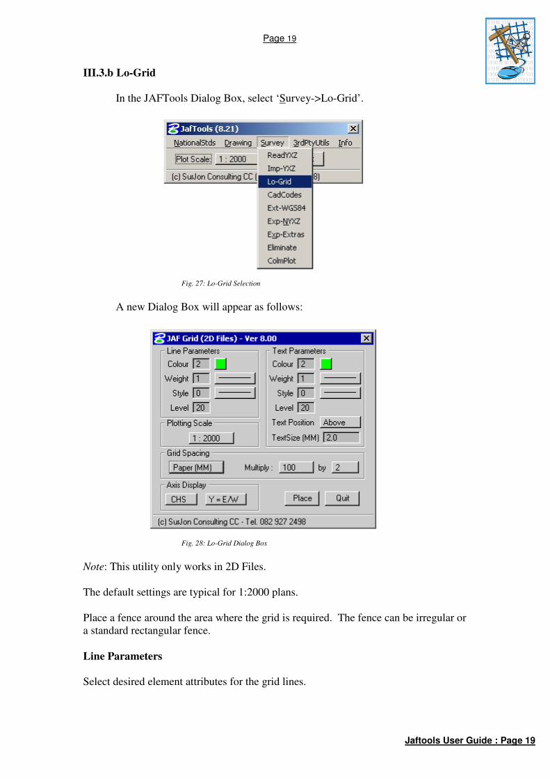
III.3.b Lo-Grid
In the JAFTools Dialog Box, select ‘Survey->Lo-Grid’.
Fig. 27: Lo-Grid Selection
A new Dialog Box will appear as follows:
Fig. 28: Lo-Grid Dialog Box
Note: This utility only works in 2D Files.
The default settings are typical for 1:2000 plans.
Place a fence around the area where the grid is required. The fence can be irregular or
a standard rectangular fence.
Line Parameters
Select desired element attributes for the grid lines.
Page 20
Jaftools User Guide : Page 20
Text Parameters
Select desired element attributes for the Y&X Grid Values
TextSize will be the size of the text when plotted on paper at the selected scale.
Plotting Scale
Choose the desired scale that the final paper plot will be done.
Note: This scale option is not related to the JAFTools Scale setting.
Grid Spacing
The grid spacing can be specified in two ways, either in units on the ground, or
units(mm) on the plotted paper, which is the most common.
The ground units choice is handy if somebody wishes to count all the houses in, for
example, 1Km block areas.
The ‘Multiply’ option is used to specify how many grid-spacing units. The default is
200, which is 200mm on the final paper plot.
Any combination of ‘Multiply’ figures can be used to get the required units. For
example, the instead of ‘100 by 2’, ’50 by 4’ could be used to get the same result.
Axis Display
Choose either ‘CHS’ or ‘AS-IS’.
CHS will cause the Grid Values to be opposite that of the actual design file values.
i.e. ‘–X’ co-ords will be positive ‘+X’ on the Grid.
AS-IS will cause the Grid Values to be the same as the actual design file values.
Y=E/W or Y=N/S
Always use Y=E/W, as this is the standard for South Africa.
Y=N/S is provided as an option, should there ever be reason to display grids on some
user-defined local system.

Page 21
Jaftools User Guide : Page 21
III.3.c CadCodes
In the JAFTools Dialog Box, select ‘Survey->CadCodes’.
Fig. 31: CadCodes Selection
A new Dialog Box will appear as follows:
Fig. 32: CadCodes Dialog Box

Page 22
Jaftools User Guide : Page 22
This utility assists the user to ‘build’ the 5-digit code used to describe a Rural Line
Structure.
The code consists of five characters: 1 Pole Size
2 MV Equipment
3 LV Equipment
4 Pole Top Box
5 Auxiliary Equipment
The dialog box above is divided into five sections, corresponding to the five
characters.
Choose one option in each section, to build the code.
Choose a multiplier for the structures if desired.
Select the Text Justification desired.
Fig. 32a: CadCodes Multiplier Option
Select the scale that the drawing will be plotted at.
Note: This scale option is not related to the JAFTools Scale setting.
Select ‘Place’.
Position the CODE where desired in the drawing, using a Data Point.

Page 23
Jaftools User Guide : Page 23
III.3.d Ext Wgs84
In the JAFTools Dialog Box, select ‘Survey->Ext-WGS84’.
Fig. 33: ExtWGS84 Selection
A new Dialog Box will appear as follows:
Fig. 34: ExtWGS84 Dialog Box
This utility will extract TEXT items within a fence, to an ASCII file, Geographical (Latitude/Longitude) co-ordinates. There must be no spaces in the TEXT strings. First, place a FENCE around the TEXT items to be exported. Choose ‘OutFile’ to indicate the desired target ASCII file to be created. Click a ‘Data Point’ in the view when the TEXT items are displayed, then select ‘Export’. The ASCII file will then be created as indicated.
Page 24
Jaftools User Guide : Page 24
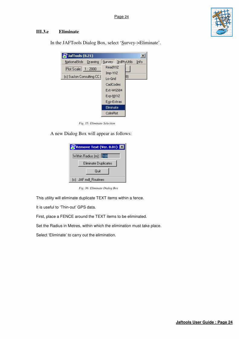
III.3.e Eliminate
In the JAFTools Dialog Box, select ‘Survey->Eliminate’.
Fig. 35: Eliminate Selection
A new Dialog Box will appear as follows:
Fig. 36: Eliminate Dialog Box
This utility will eliminate duplicate TEXT items within a fence. It is useful to ‘Thin-out’ GPS data. First, place a FENCE around the TEXT items to be eliminated. Set the Radius in Metres, within which the elimination must take place. Select ‘Eliminate’ to carry out the elimination.

Page 25
Jaftools User Guide : Page 25
III.3.f ColmPlot (Column Plot)
In the JAFTools Dialog Box, select ‘Survey->ColmPlot’.
Fig. 37: ColmPlot Selection
A new Dialog Box will appear as follows:
Fig. 38: ColmPlot Dialog Box
This utility will import ASCII Geographical co-ordinates. Set the desired Text Size, Level, Colour, etc. Select the ASCII file (Format (DD MM SS.SSSS, DD MM SS.SSSS, N,N,) (Any number of ‘Columns’, separated by a comma) Select the Datum of the ASCII data. (The same Datum will be used to create the DGN file). Select which columns the Latitude, Longitude and Text items are in. Select ‘Import’.
Page 26
Jaftools User Guide : Page 26
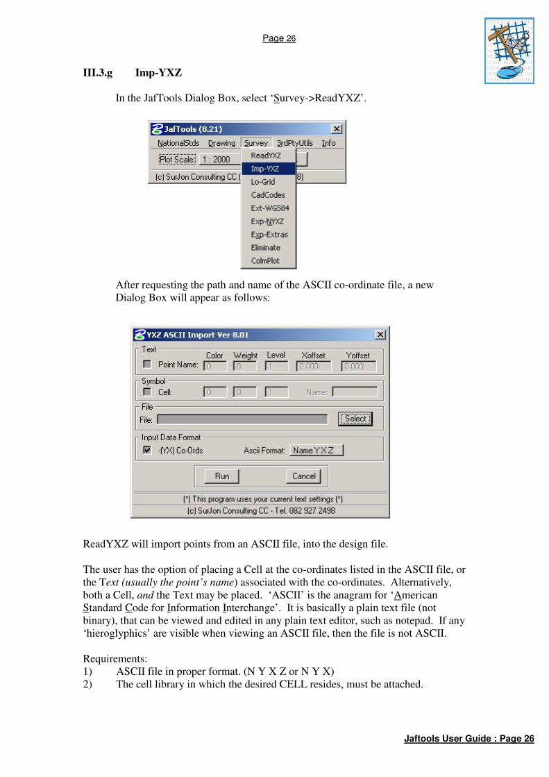
III.3.g Imp-YXZ
In the JafTools Dialog Box, select ‘Survey->ReadYXZ’.
After requesting the path and name of the ASCII co-ordinate file, a new
Dialog Box will appear as follows:
ReadYXZ will import points from an ASCII file, into the design file.
The user has the option of placing a Cell at the co-ordinates listed in the ASCII file, or
the Text (usually the point’s name) associated with the co-ordinates. Alternatively,
both a Cell, and the Text may be placed. ‘ASCII’ is the anagram for ‘American
Standard Code for Information Interchange’. It is basically a plain text file (not
binary), that can be viewed and edited in any plain text editor, such as notepad. If any
‘hieroglyphics’ are visible when viewing an ASCII file, then the file is not ASCII.
Requirements:
1) ASCII file in proper format. (N Y X Z or N Y X)
2) The cell library in which the desired CELL resides, must be attached.

Page 27
Jaftools User Guide : Page 27
Text
This program uses the current text settings, i.e. size, justification and font.
If the text is to be plotted at any specific size for a desired scale output, then the text
size must be calculated and set prior to clicking ‘OK’.
N Y X Z (At least ONE SPACE between fields, no spaces in the Name (N))
or
PtName Y X
E.g.:
ROCK -78234.42 3218336.65 254.32
MH -78106.22 3218332.23 252.34
or
ROCK -78234.42 3218336.65
MH -78106.22 3218332.23
ASCII File rules:
There must be at least one space between the fields (columns).
There can be many spaces, but there must be at least one.
The data does not have to be in straight columns, just as long as there is at least one
space between the fields.
The spaces must not be TABS.
There must not be any spaces in the PtName (N) field. If your ASCII file has names
with spaces in, they must be replaced with underscores(_) or hyphens (-).
The decimal character must be a point, not a comma.
The Fields/Columns must not be separated by commas, only spaces.
Input Data Format
Select ‘Yes’ if the signs of the Y,X co-ordinates in the ASCII file must be changed
before plotting. I.e. The Eskom standard specifies that X co-ords must display as
negative in MicroStation. If the X Co-ord value in the ASCII file is positive, then this
box should be checked.
ASCII Format
Name Y X Z is used if PtName is the 1st Field/Column in the ASCII file.
See example file ‘NYXZ-EG.TXT’
Y X Z Name is used if PtName is the 4th
Field/Column in the ASCII file.
See example file ‘YXZN-EG.TXT’
Once all selections have been made, select ‘OK’, and the program will run, and
indicate in the MicroStation Command Window, how many points were plotted.

Page 28
Jaftools User Guide : Page 28
Example
Attach Cell Library ‘JafTools’
Set Active Cell to ’TRIG’
Set Text Size to 130 (TX=130)
Set Active Scale to 50 (AS=50)
Load ‘READYXZ’ mdl application.
Click –(YX) Co-Ords to reverse the signs
Use example ASCII File ‘NYXZ-EG.TXT’
Select ‘Run’ to import the ASCII File.

Page 29
Jaftools User Guide : Page 29
III.3.h Export NYXZ to ASCII File
In the JafTools Dialog Box, select ‘Survey->Exp-WGS84(DMS)’.
With this routine, it is possible to export text items to an ASCII file in various
formats.
Fig. 23: Exp-NYXZ Field Delimiter Options
By ‘Checking’ the ‘-[YX] Co-Ords’ box, the output co-ordinates will have their signs
reversed. Output fields can be separated by a comma, single space or in column
format.

Page 30
Jaftools User Guide : Page 30
Fig. 24: Exp-NYXZ Element Group Options
Text items to be exported can be specified by means of a fence, individual items or all
the text items in the Dgn File.
Fig. 25: Exp-NYXZ Decimal Options
Inspection of the resultant ASCII File values, it may be noted that the decimal place
may be shifted from its correct position. This may occur if the working units of the
file are not in the standard ‘Eskom Format’ (i.e. 100:1). The ‘Shift Decimal’ option is
provided to compensate for this occurrence, if required.
Page 31
Jaftools User Guide : Page 31
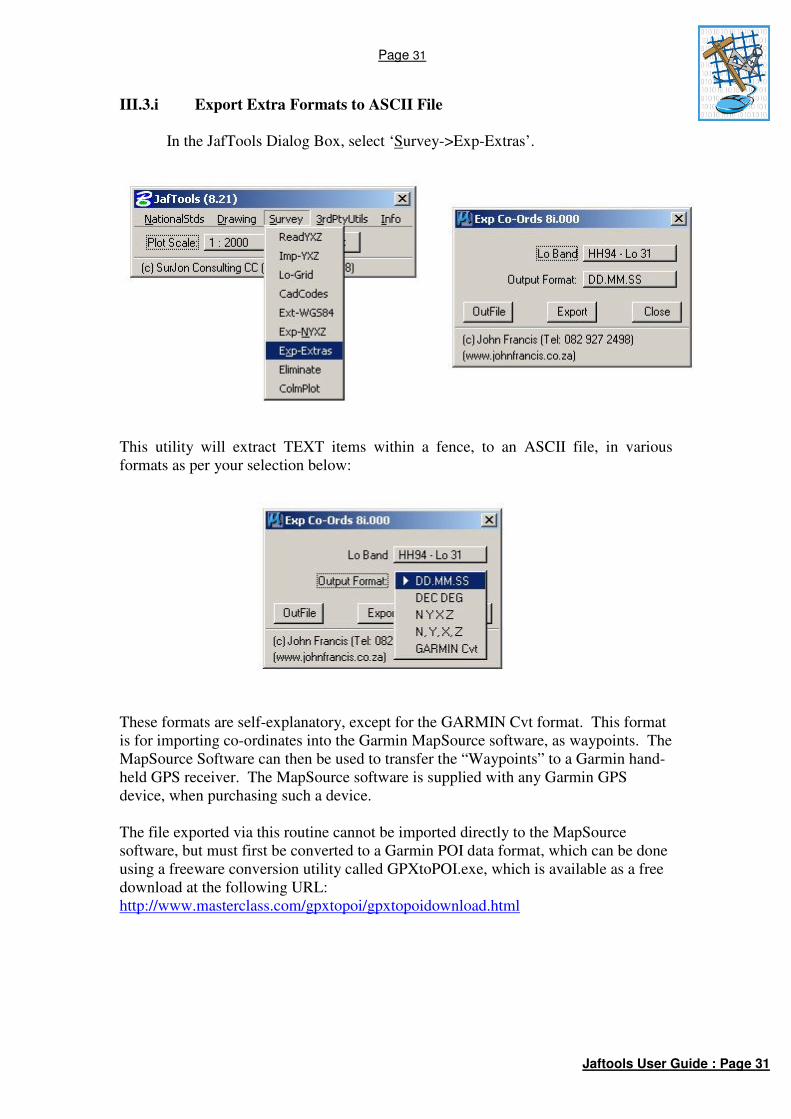
III.3.i Export Extra Formats to ASCII File
In the JafTools Dialog Box, select ‘Survey->Exp-Extras’.
This utility will extract TEXT items within a fence, to an ASCII file, in various
formats as per your selection below:
These formats are self-explanatory, except for the GARMIN Cvt format. This format
is for importing co-ordinates into the Garmin MapSource software, as waypoints. The
MapSource Software can then be used to transfer the “Waypoints” to a Garmin hand-
held GPS receiver. The MapSource software is supplied with any Garmin GPS
device, when purchasing such a device.
The file exported via this routine cannot be imported directly to the MapSource
software, but must first be converted to a Garmin POI data format, which can be done
using a freeware conversion utility called GPXtoPOI.exe, which is available as a free
download at the following URL:
http://www.masterclass.com/gpxtopoi/gpxtopoidownload.html

Page 32
Jaftools User Guide : Page 32
III.4 INFO
People make mistakes, so these tools assist in rectifying some issues.
III.4.a Restore Default Cell Library
In the JafTools Dialog Box, select ‘Utils-> Restore Default Cell Library’.
This will replace the default cell libraries required for JafTools to function correctly.
Use this when the required cells do not appear in your drawing when choosing to
place them via the JafTools sub-menus.
III.4.b License Info
In the JafTools Dialog Box, select ‘Info-> License Info’.
This will display information about the current license and its validity.
Page 33
Jaftools User Guide : Page 33
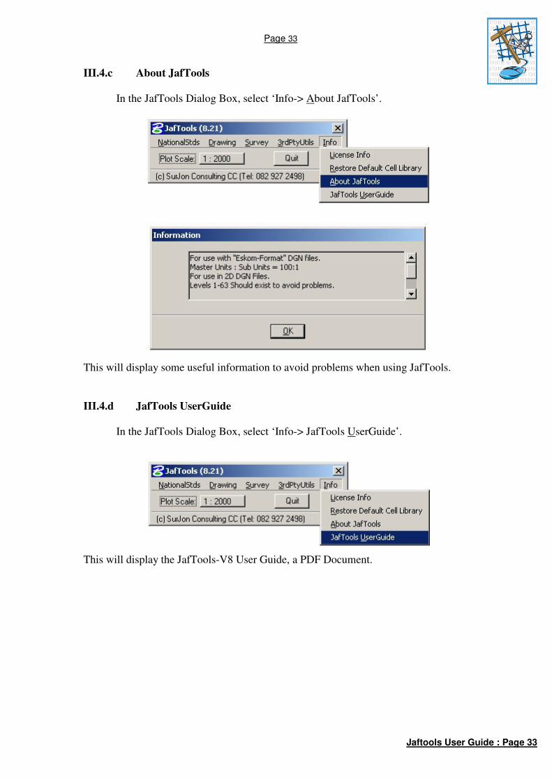
III.4.c About JafTools
In the JafTools Dialog Box, select ‘Info-> About JafTools’.
This will display some useful information to avoid problems when using JafTools.
III.4.d JafTools UserGuide
In the JafTools Dialog Box, select ‘Info-> JafTools UserGuide’.
This will display the JafTools-V8 User Guide, a PDF Document.

Page 34
Jaftools User Guide : Page 34
PART IV THIRD PARTY APPLICATIONS
These applications are available on the pull-down menu ‘3rdPtyUtils’.
These are applications written by other sources/companies. The intention is to
provide access to other third party developers’ programs that may be useful. These
applications were not written by JAF, and are therefore not supported, but are
included as-is, hopefully making somebody’s life a little easier in the long term.