james bay lithium mine
TRANSCRIPT

JAMES BAY LITHIUM MINE ENVIRONMENTAL IMPACT ASSESSMENT
CHAPTER 8: ASSESSMENT OF CUMULATIVE EFFECTS
JULY 2021 (VERSION 2)


GALAXY LITHIUM (CANADA) INC. – JAMES BAY LITHIUM MINE ENVIRONMENTAL IMPACT ASSESSMENT – JULY 2021 CHAPTER 8: ASSESSMENT OF CUMULATIVE EFFECTS
WSPNO. 201-12362-00
PAGE i
TABLE OF CONTENTS
8 ASSESSMENT OF CUMULATIVE EFFECTS ..................................................... 8-1
8.1 LEGAL FRAMEWORK AND GENERAL NOTIONS ..................................................................... 8-1
8.2 METHOD FOR ASSESSING CUMULATIVE EFFECTS ..................................................................... 8-1
8.2.1 GENERAL APPROACH ................................................................... 8-1
8.2.2 IDENTIFICATION OF THE VALUED COMPONENTS TO STUDY ............................................................................................. 8-2
8.2.3 DEFINITION OF SPATIAL AND TEMPORAL BOUNDARIES .......... 8-2
8.2.4 IDENTIFICATION, SELECTION AND DESCRIPTION OF PAST, PRESENT AND FUTURE ACTIVITIES, PROJECTS AND EVENTS ........................................................................................... 8-3
8.2.5 DESCRIPTION OF THE REFERENCE STATUS ............................. 8-3
8.2.6 DESCRIPTION OF HISTORIC TRENDS ......................................... 8-3
8.2.7 IDENTIFICATION AND IMPORTANCE OF CUMULATIVE EFFECTS ......................................................................................... 8-4
8.2.8 MITIGATION MEASURES AND MONITORING PROGRAMS ......... 8-4
8.3 PROJECT ISSUES ...................................................... 8-4
8.4 IDENTIFICATION OF VALUED COMPONENTS ........ 8-5
8.4.1 SPATIAL AND TEMPORAL BOUNDARIES ..................................... 8-6
8.4.2 VALUED COMPONENTS................................................................. 8-7
8.5 PROJECTS, ACTIVITIES OR EVENTS LINKED TO VECS AND VSCS ................................................ 8-14
8.5.1 INFRASTRUCTURE AND SERVICES ........................................... 8-14
8.5.2 DEVELOPMENT OF NATURAL RESOURCES ............................. 8-21
8.5.3 USE OF THE TERRITORY BY NON-INDIGENOUS PEOPLE ....... 8-21
8.5.4 WILDLIFE OR PROTECTED TERRITORIES ................................. 8-22
8.5.5 DISTURBANCES, NATURAL AND OTHER ................................... 8-25
8.6 ANALYSIS OF CUMULATIVE EFFECTS ON VCS .. 8-26
8.6.1 BATS .............................................................................................. 8-26
8.6.2 BIRD SPECIES AT RISK ......................................................... 8-29
8.6.3 LAND USE FOR TRADITIONAL PURPOSES ................................ 8-35
8.7 RESULTS OF THE CUMULATIVE EFFECTS ASSESSMENT ........................................................... 8-40
GALAXY LITHIUM (CANADA) INC. – JAMES BAY LITHIUM MINE ENVIRONMENTAL IMPACT ASSESSMENT – JULY 2021 CHAPTER 8: ASSESSMENT OF CUMULATIVE EFFECTS
WSPNO. 201-12362-00
PAGE ii
TABLE OF CONTENTS (continued)
TABLES
TABLE 8-1 TEMPORAL AND SPATIAL SCOPE, SELECTION CRITERIA AND INDICATORS FOR THE VCS SELECTED FOR THE ASSESSMENT OF CUMULATIVE EFFECTS ........................ 8-6
TABLE 8-2 PROJECTS, ACTIVITIES AND EVENTS LIKELY TO HAVE AN IMPACT ON THE VCS .............................................................. 8-15
TABLE 8-3 PROPORTION OF ENVIRONMENT TYPES AFTER THE COMPLETION OF THE LA GRANDE COMPLEX AND EASTMAIN-1-A–SARCELLE–RUPERT GENERATING STATIONS .......................... 8-19
TABLE 8-4 SITUATION OF RECONSTRUCTION ON THE BILLY-DIAMOND ROAD ..................... 8-20
TABLE 8-5 ANNUAL INDEX OF SPECIAL STATUS SPECIES FOR BCR 7 IN CANADA AND BCR 8 IN QUÉBEC FOR THE FIRST AND LAST INVENTORY YEARS .............................. 8-32
TABLE 8-6 HISTORICAL TREND FOR TERRESTRIAL BIRDS OF VALUED STATUS ..................................................... 8-33
MAPS
MAP 8-1 NATURAL DISTURBANCES ......................... 8-9 MAP 8-2 ANTHROPOGENIC DISTURBANCES ........ 8-11
FIGURES FIGURE 8-1 BIRD CONSERVATION REGION
(BCR) 7 ....................................... 8-30 FIGURE 8-2 BIRD CONSERVATION REGION
(BCR) 8 ....................................... 8-31

GALAXY LITHIUM (CANADA) INC. – JAMES BAY LITHIUM MINE ENVIRONMENTAL IMPACT ASSESSMENT – JULY 2021 CHAPTER 8: ASSESSMENT OF CUMULATIVE EFFECTS
WSPNO. 201-12362-00
PAGE 8-1
8 ASSESSMENT OF CUMULATIVE EFFECTS
8.1 LEGAL FRAMEWORK AND GENERAL NOTIONS
As per the requirements of the Canadian Environmental Assessment Act, 2012 (CEAA, 2012), a project’s cumulative environmental effects must be analyzed with regard to the valued environmental components (VECs) and valued social components (VSCs). The Environment Quality Act (LQE) also addresses the fact that cumulative effects1 must be taken into consideration during the environmental assessment phase of a project. To meet these requirements while also complying with the provisions of the Guidelines for the Preparation of an Environmental Impact Statement, and with the provisions of the provincial guideline titled Directive pour le projet de mine de lithium Baie-James (file 3214-14-055), the cumulative effects of this project were assessed.
8.2 METHOD FOR ASSESSING CUMULATIVE EFFECTS
8.2.1 GENERAL APPROACH
The analysis of cumulative effects is based on the method described in the Practitioner’s Guide created for the CEAA (Hegmann and coll., 1999) and the CEAA’s related Operational Policy Statement (ACÉE, 2015). The document titled Addressing Cumulative Environmental Effects (ACÉE, 2018) was also consulted.
The main steps of the method used are the following:
— identification of the environmental VCs, i.e., the environmental components valued by experts or by the populations concerned, and likely to be changed or affected by the project;
— definition of each VC’s spatial and temporal boundaries, as well as the indicators for describing their evolution;
— identification, description and selection of past, present or future projects, actions or events that could potentially interact or have interacted with a VC;
— description of the reference status for each VC selected;
— description of the historic trends for each VC selected;
— definition of the cumulative effects for each VC selected;
— development of mitigation measures and processes for monitoring cumulative effects.
To be subject to an assessment of cumulative effects, a VC must:
— be highly valued by experts or by the populations concerned;
— be identified or protected by law;
— be prone to changing due to the effects of various elements -- both associated with or external to the project;
— be analyzable, based on reliable and adequate data, in terms of both the reference status and historical trends.
1 In this chapter, the terms “cumulative impacts” and “cumulative effects” have the same meaning. The only difference is that
impact is preferred by the MELCC while effect is used by the IAAC. To make this chapter easier to read, effect will be used and considered as a synonym for impact.

WSP NO. 201-12362-00 PAGE 8-2
GALAXY LITHIUM (CANADA) INC. – JAMES BAY LITHIUM MINEENVIRONMENTAL IMPACT ASSESSMENT – JULY 2021
CHAPTER 8: ASSESSMENT OF CUMULATIVE EFFECTS
8.2.2 IDENTIFICATION OF THE VALUED COMPONENTS TO STUDY
The assessment of the project effects made it possible to identify the main issues and the repercussions on natural and social environment components. It also allowed for understanding the primary concerns of the James Bay population and Cree communities touched by the project, that were recorded at the information and consultation sessions held with the local population and representatives of the various organizations concerns. Taken together, these two elements enabled the identification of the VCs associated with the project and, ultimately, the selection of those that would be subject to an assessment of cumulative effects.
As it stands, the assessment of cumulative effects is contingent on the VCs having potential for cumulative effects with other projects or actions in the areas where these effects will be examined.
8.2.3 DEFINITION OF SPATIAL AND TEMPORAL BOUNDARIES
This step involves establishing the spatial and temporal boundaries of the VCs selected to better structure their analysis.
8.2.3.1 SPATIAL BOUNDARIES
The spatial boundaries must contain a territory that, while not overly vast, is large enough to comprise all the areas where cumulative effects could occur (Hegmann and coll., 1999). If the territory is too small, certain impacts could be omitted. The areas of influence of the various projects or actions considered (past, present and future) must be established while fixing boundaries beyond which any cumulative effects would essentially be negligible. Spatial boundaries can be tailored to each VC selected. Choosing spatial boundaries thus requires:
— understanding the spatial distribution of the effects of the project being examined;
— identifying similar effects associated with other projects, activities, events, etc. and which are superimposed in space;
— ensuring that the boundaries consider VC abundance and distribution;
— making sure that the boundaries are environmentally and socially acceptable;
— confirming that the boundaries allow for data collection and analysis for each VC involved.
According to Hegmann and coll. (1999), spatial boundaries must be flexible. It is best, in fact, to establish multiple spatial boundaries that expand or retract based on the social and ecological relationships observed and the VCs analyzed.
8.2.3.2 TEMPORAL BOUNDARIES
As for temporal boundaries, two markers (one in the past and one in the future) must be identified. In theory the marker for the past precedes the effects of the actions or projects analyzed, while the marker for the future corresponds to the moment when the environmental conditions that existed prior to the product are restored or when a certain equilibrium is achieved (Hegmann and coll., 1999).
Boundaries in the past should be selected by giving due consideration to:
— the importance of selecting a period for which there is enough information available about the VCs to adequately describe the initial condition or reference status;
— the moment when the effects associated with a proposed action first occurred;
— the moment when effects similar to those of concern first occurred;
— the moment when the various uses of the territory were established;
— the pre-disruption conditions (historical reference point).

GALAXY LITHIUM (CANADA) INC. – JAMES BAY LITHIUM MINE ENVIRONMENTAL IMPACT ASSESSMENT – JULY 2021 CHAPTER 8: ASSESSMENT OF CUMULATIVE EFFECTS
WSPNO. 201-12362-00
PAGE 8-3
Boundaries in the future should be selected by giving due consideration to:
— the end of the project operation period;
— the period following the end of the project and reclamation of the site;
— the period following the reclamation of VCs to their post-disruption condition;
— the availability of information regarding other projects.
In practice, it bears remembering that when one goes back over long periods (more than 10 years) or looks forward into the future (more than 5 years), it becomes harder to obtain information, which means subsequent analysis can become increasingly speculative. Because of this, forecasts become increasingly uncertain the longer the projection period of the cumulative effects extends. It is generally accepted that the probability of occurrence associated with future projects or actions beyond 10 years is very hard to accurately predict (Bérubé, 2007).
8.2.4 IDENTIFICATION, SELECTION AND DESCRIPTION OF PAST, PRESENT AND FUTURE ACTIVITIES, PROJECTS AND EVENTS
During the assessment of cumulative effects, it is critical that the most comprehensive inventory possible be completed, based on the available information as well as on the projects, activities and other interventions likely to have had an effect on, be currently affecting or to one day impact the VCs selected for analysis. This assessment must be conducted within the defined spatial and temporal boundaries and comprise:
— all projects, regardless of type;
— all human actions, regardless of type;
— all events, regardless of type;
— the laws and regulations of the three main governments involved (Eeyou Istchee James Bay Regional Government, Québec Government and Government of Canada), all of which influence or are likely to influence the VCs being examined.
The next step consists of identifying the actions, projects, events and laws and regulations that could have had a significant effect on the respective VCs, and of briefly describing the influence in question using indicators. The analysis of cumulative effects only concerns the negative effects ensuing from an action (Hegmann and coll., 1999).
Indicators are known elements that allow for translating the influence of various previously mentioned actions or interventions both spatially and temporally. VCs can themselves be indicators (Hegmann and coll., 1999).
8.2.5 DESCRIPTION OF THE REFERENCE STATUS
The reference status corresponds to the situation that existed x number of years prior (i.e., the temporal boundary situated in the past). The description of this status is part of the available information, but may be very limited for certain VCs. This is the reason why the available data must be taken into consideration when setting the temporal boundaries for each VC.
8.2.6 DESCRIPTION OF HISTORIC TRENDS
Historic trends ensue from the analysis of the joint influence of the most important projects, actions and events. These trends incorporate the findings associated with the actions identified as having the potential to substantially impact VCs and are expressed from the reference status up until the completion of the project impact assessment.
WSP NO. 201-12362-00 PAGE 8-4
GALAXY LITHIUM (CANADA) INC. – JAMES BAY LITHIUM MINEENVIRONMENTAL IMPACT ASSESSMENT – JULY 2021
CHAPTER 8: ASSESSMENT OF CUMULATIVE EFFECTS
8.2.7 IDENTIFICATION AND IMPORTANCE OF CUMULATIVE EFFECTS
This step focuses on establishing, for each VC, whether or not there are cumulative effects or a potential cumulative effect. The decision in this regard rests on the following elements:
— historic trends;
— likely or current projects, actions and events (within the previously defined temporal boundary for the future).
According to Hegmann and coll. (1999), determining the importance of the effects within the context of an assessment of cumulative effects is basically the same as when doing so within an impact assessment. In other words, cumulative effects can be assessed in terms of their intensity, duration and scope. The integration of these criteria then makes it possible to designate a project’s cumulative effects as important, unimportant or unknown. Residual effects of high or very high importance are deemed important, while those with a medium, low or very low importance are considered unimportant.
The analysis of cumulative effects can incorporate quantitative analysis and discussions of qualitative elements. A qualitative analysis is carried out in the absence of a technical quantitative analysis or when examining qualitative elements is deemed relevant. The analysis of cumulative effects is nonetheless essentially a qualitative analysis. It concerns resources that will have a residual effect following the implementation of mitigation measures identified during the project impact assessment phase.
The cumulative effect will be considered important if the experts believe that the project will significantly diminish the existing VC. Inversely, the cumulative effect will be considered unimportant if the VC is not significantly influenced by the project’s actions. If there is insufficient information such that it becomes impossible to form an opinion as to the project’s cumulative effect on a component, the cumulative impact will be considered unknown.
Hegmann and coll. (1999) indicated that the following issues must be considered when assessing the probability that a project’s implementation would have a cumulative effect:
— Are the environmental effects harmful?
— Are the harmful environmental effects significant?
— Are the significant and harmful environmental effects likely to occur?
8.2.8 MITIGATION MEASURES AND MONITORING PROGRAMS
This last step involves an assessment of each VC to determine whether the identified cumulative effect calls for mitigation measures and additional environmental monitoring programs other than those proposed in the project’s environmental assessment.
8.3 PROJECT ISSUES
The assessment of cumulative effects considers some of the project issues that came to light following public consultations and interviews with stakeholders from James Bay and Cree communities since 2017 as well as during the EIA (chapter 5). The project issues considered are:
— protecting the quality of the environment (quality of the water, the air, the soil, and the wildlife and its habitat);
— protecting the biodiversity (threatened or vulnerable species and their habitats);
— upholding the integrity of traditional activities;
— ensuring sanitary conditions at and around the project site;
— safeguarding the Cree community’s well-being.
It must be remembered that other issues may surface during various communication activities concerning the project.

GALAXY LITHIUM (CANADA) INC. – JAMES BAY LITHIUM MINE ENVIRONMENTAL IMPACT ASSESSMENT – JULY 2021 CHAPTER 8: ASSESSMENT OF CUMULATIVE EFFECTS
WSPNO. 201-12362-00
PAGE 8-5
8.4 IDENTIFICATION OF VALUED COMPONENTS
As indicated in Schedule 2 of the Canadian Environmental Assessment Act (which refers to subparagraph 5(1) a) and subsection 5(3)), the valued components to be considered when assessing a project’s cumulative effects could include:
— fish and fish habitat;
— migratory birds;
— species at risk;
— all other relevant components.
According to the MDDELCC (now the MELCC) guideline for the project, the valued components to consider when assessing cumulative effects should be associated with project issues, namely:
— use of the territory by the Cree population;
— the region’s socioeconomic situation;
— the community’s use of the sector for cultural purposes;
— recreational and tourism activities, particularly sport hunting and fishing;
— the plant and wildlife species at risk;
— the wildlife and its habitat;
— climate change.
Furthermore, and still as per these same guidelines, the impact of the workers’ presence on wildlife must be taken into consideration, as must the repercussions this presence could have on future hunting and fishing by the Cree population. On another note, the traditional knowledge of the communities concerned must be included when assessing cumulative environmental effects.
As part of this specific project, three VCs were selected for an analysis of cumulative effects; the Chiroptera (bats) at risk, bird species at risk and traditional use of the territory by the Cree. It bears noting that several occurring, and potentially occurring, species at risk and of special concern in the study area were not considered as valued components for the cumulative effects analysis due to the low potential for the presence of these species and the low abundance of individuals in the area. These species include wolverine, least weasel, rock vole, southern bog lemming, woodland caribou (boreal population) and caribou (eastern migratory population)2. Fish and birds were not selected, due to few individuals and limited varieties having been identified during the field inventories. The moose inventory also attested to a similar trend. The effects of the project were thus assessed as minor and only slightly likely to influence the VCs on a larger scale. In addition, the interviews of the James Bay region’s socioeconomic stakeholders indicated that there were no recreational and tourism activities practised by non-Indigenous people and no cultural activities near the site. However, Cree users of trapline RE2 indicated that non-Natives have often hunted moose and fished on the Eastmain River and near the Billy-Diamond highway. There are, however, boat launches, the closest of which is 9 km from the mining site.
Even though the overall project impact on bats is judged to be minor, this species was nonetheless selected as a VC for the analysis of cumulative effects, chiefly for the reasons indicated hereafter. Firstly, the presence of bat species with a special status in the project zone was confirmed during the 2017 inventories, as was their low numbers. Secondly, the presence and rapid spread of the white-nose syndrome (WNS) in Québec, now heralded as the key factor behind the decline of bat populations in northeastern North America (section 8.5.5.2), has made bats more vulnerable to cumulative effects than any other wildlife species found in the area being studied.
2 Detailed information on the low potential for the presence of the caribou is presented in Section 6.3.

WSP NO. 201-12362-00 PAGE 8-6
GALAXY LITHIUM (CANADA) INC. – JAMES BAY LITHIUM MINEENVIRONMENTAL IMPACT ASSESSMENT – JULY 2021
CHAPTER 8: ASSESSMENT OF CUMULATIVE EFFECTS
Although the significance of the residual effect of the overall project is considered minor for birds, bird species at risk were selected as a VC for the cumulative effects analysis mainly for the following reasons. First, two species were confirmed as present in the local study area. Also, some special status bird species may be potentially occurring in the local study area given that it contains their preferred habitats. The project deforestation and footprint will result in potential temporary or permanent habitat loss for bird species at risk occurring and potentially occurring in the local study area. The precarious status of these species combined with the loss of potential habitat makes them more vulnerable to cumulative effects than other bird species present in the study area.
The traditional use of the territory by the Cree was also selected as a VC for the analysis of cumulative effects, given that this use is linked to project issues, was identified as a concern during the public consultations, and will be somewhat significantly impacted by the project (impact of medium importance during the construction and operation phases). Also, other specific activities (past and future) have had, are having and will have an effect on this component. Comparatively, traffic, in spite of impacting the quality of life and having been noted as a concern during the public consultations, was not selected as a VC. In fact, the project will require that 25 additional trucks travel over the road network each day during the operation phase; according to the traffic statistics compiled by the SDBJ (section 8.5.3), this represents an increase of 16% in the number of vehicles travelling on these roads.
8.4.1 SPATIAL AND TEMPORAL BOUNDARIES
Table 8-1 illustrates the selection criteria, spatial and temporal boundaries and indicators for each VC selected for the assessment of cumulative effects. Because of each VC’s specific characteristics, there may be variations in the spatial and temporal boundaries.
Table 8-1 Temporal and spatial scope, selection criteria and indicators for the VCs selected for the assessment of cumulative effects
VCs Selection criteria Indicator Temporal scope Spatial scope
Biological environment
Bats Special status species Number of sightings of the following species: Hoary bat
Eastern red bat
Northern long-eared bat
Little brown myotis
2003–2028 Radius of 110 km around the project site
Bird species at risk
Species at risk Population and distribution range assessment of the following species: Common Nighthawk Short-eared Owl Bank Swallow Olive-sided Flycatcher Canada Warbler Red-necked Phalarope Rusty Blackbird Yellow Rail
1989-2028 Radius of 110 km around the project site
Social environment
Traditional use of the territory by the Cree
Activities valued by the Cree (hunting, fishing, trapping, gathering, and cultural, family and healing gatherings)
Use of the territory 1980–2028 The territory of the Eastmain community as well as the traplines assigned to the latter
GALAXY LITHIUM (CANADA) INC. – JAMES BAY LITHIUM MINE ENVIRONMENTAL IMPACT ASSESSMENT – JULY 2021 CHAPTER 8: ASSESSMENT OF CUMULATIVE EFFECTS
WSPNO. 201-12362-00
PAGE 8-7
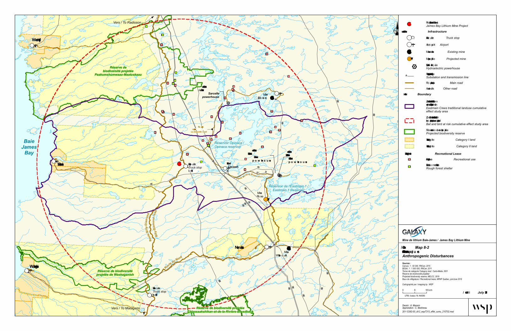
Maps 8-1 and 8-2 show the limits of the two study areas used for the analysis of cumulative effects. On the one hand, the study area defined for the assessment of cumulative effects on use of the territory includes the territory of the Eastmain community as well as the traplines assigned to the latter. On the other hand, the study area designated for assessing the cumulative effects on bats and the bird species at risk corresponds to the territory included within a radius of 110 km around the planned mining site.
8.4.2 VALUED COMPONENTS
8.4.2.1 BATS (CHIROPTERA)
Four bat species were selected as VCs due to their special status at the federal and provincial levels. These include the hoary bat, the northern myotis and the little brown myotis, whose presence in the study area was confirmed during the 2017 surveys. Also selected was the eastern red bat, a bat species with a special status at the provincial level and which could potentially be found in the study area (Jutras and coll., 2012).


#*
#*
#*#*
#*
#*
#*#*
#*
#*
#*
#*
#*
!
!!
Re lais routie rTruck stopkm 257
Re lais routie r /Truck stopkm 381
Centrale del'Eastmain-1 /Eastmain-1powerhouse
Min eÉléon ore
Centrale dela Sarcelle /
Sarcellepowerhouse
Min eWhabouchi
BaieJames
Bay
Vers / To Radisson
RouteBilly-Diamond
Billy-Diamondroad
Waskaganish
Eastmain
Wemindji
Vers / To Matagami
Centrale del'Eastmain-1-A /Eastmain-1-Apowerhouse
Nemaska
Réservoir Opinaca /Opinaca reservoir
Réservoir de l'Eastmain 1 /Eastmain 1 Reservoir
RouteduNord
Min eRose
(fe rm é /closed)
!
Route dela Sarcelle /
La Sarcelle road
RouteMuskeg– Eastmain-1
450 kV (4003-4004)
735 kV (7081)
735 kV (7082)
735 kV (7080)
735 kV (7078)
735 kV (7076)
735 kV (7062)
735 kV (7063)
69 kV (615)315 kV(3189)
69 kV (614)
69 kV (613)
735 kV (7061)
120 kV (1519)
735 kV (7059)
735 kV (7069)
69 kV (612)
Limites / Boundary
Proje t m in e de lithium Baie-Jam e s /James Bay Lithium Mine Project
Feux de forêt / Forest Fire
2000 à / to 20092010 à / to 2018
Infrastructures / InfrastructureRe lais routie r / Truck stopAéroport / Airport
!( Min e e xistan te / Existing mine
! Ce n trale hydroéle ctrique /Hydroelectric powerhousePoste e t lign e de tran sport d'én e rgie /Substation and transmission lineRoute principale / Main roadAutre route / Other road
#*
!( Min e proje tée / Projected mine
Zon e d’étude de s e ffe ts cum ulatifs sur le schiroptère s e t le s e spèce s aviaire s e n péril /Bat and bird at risk cumulative effect study area
Zon e d'étude de s e ffe ts cum ulatifs surl'utilisation du te rritoire par le s Cris d'Eastm ain /Eastmain Crees traditional landuse cumulative effect study area
1980 à / to 19891990 à / to 1999
Carte / Map 8-1Perturbations naturelles /Natural Disturbance
Mine de lithium Baie-James / James Bay Lithium Mine
Dessin : A. MassonApprobation : C. Martineau201-12362-00_c8-1_wspT314_feux_210702.mxd
UTM, fuseau 18, NAD83
0 9 18km
Sources :Canvec, 1 : 50 000, RNCan, 2015BDGA, 1 : 1 000 000, RNCan, 2011Feux de forêt / Forest fire, MFFP, 2018Cartographié par / mapping by : WSP
Juillet / July 2021

#*
#*
#*#*
#*
#*
#*#*
#*
#*
#*
#*
#*
!
!!
"
"
"
"
"
"
"
"
"
"
"
"
"
"
"
"
"
"
"
"
"
"
"
"
"
"
"
"
"
"
"
"
"
"
"
"
"
"
"
"
"
"
"
"
"
"
"
"
"
Relais ro utierTruck stopkm 257
Relais ro utier /Truck stopkm 381
Centrale del'Eastmain-1 /Eastmain-1p o w erh o u se
(Fermé /Closed)
MineÉléono re
Centrale dela Sarcelle /
Sarcellepowerhouse
MineWhab o uchi
69 kV (614)
69 kV (613
)
450 kV (4003-4004)
735 kV (7062)
735 kV (7063)
735 kV (7061)
69 kV (615)315 kV (3189)
120 kV (1519)
BaieJames
Bay
Vers / To Radisson
RouteBilly-Diamo nd
Billy-Diamondro ad
Waskaganish
Eastmain
Wemindji
Vers / To Matagami
Centrale del'Eastmain-1-A /Eastmain-1-Ap o w erh o u se
Nemaska
Réservoir Opinaca /Opinaca reservoir
Réservoir de l'Eastmain 1 /Eastmain 1 Reservoir
Ro utedu Nord
MineRo se
!
Ro u te dela Sarcelle /
La Sarcelle road
Ro u teMu skeg–Eastmain-1
735 kV (7059) 735 kV (7069)
735 kV (7081)
735 kV (7082)
735 kV (7080)
735 kV (7078)
735 kV (7076)
69 kV (612)
Réserve debiodiversité projetée
Paakumshumwaau-Maatuskaau
Réserve de biodiversitéprojetée de Waskaganish
Réserve de biodiversité projetéeChisesaakahikan-et-de-la-Rivière-Broadback
Infrastru ctures / Infrastructure
Limites / Boundary
Bau x de villégiature / Recreational Lease
Pro jet mine de lithium Baie-James /James Bay Lithium Mine Project
Relais ro utier / Truck stopAéro po rt / Airport
!( Mine existante / Existing mine
!( Mine pro jetée / Projected mine
! Centrale hydro électriq ue /Hydroelectric powerhousePo ste et ligne de transpo rt d'énergie /Substation and transmission line#*
Ro ute principale / Main roadAutre ro ute / Other road
Zone d'étude des effets cumulatifs sur l'utilisationdu territo ire par les Cris d'Eastmain /Eastmain Crees traditional landuse cumulativeeffect study area
Réserve de b io diversité pro jetée /Projected biodiversity reserve Terres de catégo rie I / Category I land Terres de catégo rie II / Category II land
Fins de villégiature / Recreational use"
Fins d'ab ri sommaire en forêt /Rough forest shelter"
Carte / Map 8-2Pertu rbatio ns antro p iq u es Anthropogenic Disturbances
Mine de lithium Baie-James / James Bay Lithium Mine
Dessin : A. MassonApprobation : C. Martineau201-12362-00_c8-2_wspT313_effet_cumu_210702.mxd
UTM, fuseau 18, NAD83
0 9 18 km
Sources :Canvec, 1 : 50 000, RNCan, 2015BDGA, 1 : 1 000 000, RNCan, 2011Terres de catégorie/ Category land : Carto-Média, 2001Réserve de biodiversité projetée/Projected biodiversity reserve, MELCC, 2019Baux de villégiature / Recreational lease, MRNF Québec, juin/June 2018Cartographié par / mapping by : WSP
Zone d’étude des effets cumulatifs sur leschiro ptères et les espèces aviaires en péril /Bat and bird at risk cumulative effect study area
Ju illet / July 2021


GALAXY LITHIUM (CANADA) INC. – JAMES BAY LITHIUM MINE ENVIRONMENTAL IMPACT ASSESSMENT – JULY 2021 CHAPTER 8: ASSESSMENT OF CUMULATIVE EFFECTS
WSPNO. 201-12362-00
PAGE 8-13
Considering that most bats (Chiroptera) frequenting the study area will travel several hundred kilometres during the spring and autumn migratory periods, it is difficult to identify a precise area for the cumulative effects. Given the movement patterns of bats, and the different projects underway or upcoming in proximity to the project site which may have had or may have an impact on the bats, the spatial boundary considered for the cumulative effects assessment spans an area of approximately 110 km around the project (Map 8-1). However, to dispose of a minimum of data to establish the baseline condition and past conditions of bat populations, data from the Réseau québécois d’inventaires acoustiques de chauves-souris (Réseau) have been considered, although collected at Lac Bourbeau, approximately 300 kilometres southeast of the study area. The temporal boundary corresponds to the 2003 survey, the first one conducted by the Réseau in the Nord-du-Québec region; the future temporal boundary corresponds to 10 years, since the likelihood of occurrence of another project (or another source of impact) in the study area beyond this limit is too speculative.
The indicator selected is the number of counts surveyed for the targeted species in the cumulative effect study area. However, in light of the scarcity of data for this VC in the region, and since the methodologies used vary from one study to another, caution is required when considering this indicator.
8.4.2.2 BIRD SPECIES AT RISK
Eight bird species at risk were selected as VC because they have a special status at the provincial or federal level. These include the Common Nighthawk (Chordeiles minor), Short-eared Owl (Asio flammeus), Bank Swallow (Riparia riparia), Canada Warbler (Cardellina canadensis), Olive-sided Flycatcher (Contopus cooperi), Yellow Rail (Coturnicops noveboracensis), Red-necked Phalarope (Phalaropus lobatus) and Rusty Blackbird (Euphagus carolinus). The bird inventory confirmed the presence of the Common Nighthawk and the Rusty Blackbird in the local study area. The area and its vicinity could potentially contain other species since potential habitats for these species are present. Table 6-56 in Chapter 6 lists the occurrence or potential occurrence of only five bird species at risk in the local study area. Three species were added to those considered for the cumulative effects analysis, including the Canada Warbler, the Red-necked Phalarope and the Yellow Rail, because the ranges for these species overlap with the study area considered for the cumulative effect assessment.
Given the similarities between birds and bats (flight, range, migration, etc.), both groups consider the same spatial boundaries, i.e., a 110 km radius around the James Bay lithium mine project's central point. Bird Conservation Regions (BCRs) are ecologically distinct regions in Canada with similar bird communities, habitats and resource management arrangements. Data to determine the status of bird species at risk in the cumulative effects area were obtained from two BCRs, one with data from 1970 and the other from 1989. The year 1989 was therefore chosen as the past temporal boundary, whereas the future temporal boundary corresponds to 2028, as was the case for bats.
The indicator selected is the assessment of the BCR selected species populations that affect the cumulative effects study area, and the ranges of these species. This indicator should be interpreted with caution, however, as population data is incomplete or absent for some species in the BCRs, and bird ranges do not necessarily support their presence.
8.4.2.3 TRADITIONAL USE OF THE TERRITORY BY INDIGENOUS PEOPLES
The traditional use of the territory by the Eastmain Cree VC refers to the overall traditional practices, which mainly include the hunting, fishing and trapping activities of desired species, but also all other activities using the territory and its resources for ritual or social purposes.
Although use of the territory by the Cree has evolved over the years, this fundamental component of their culture is still as important as ever because of its heritage value. As a result, the link the Cree have with the recognized ancestral territory remains essential, above all, to the transmission of their culture to future generations. Also of note is the planned sturgeon spawning ground located at the east corner of the highway and the Eastmain River. The community is concerned that the project will impact the future spawning ground and would like to ensure that there is no impact. However, given the distance of the project from the proposed spawning ground, no impact is anticipated.
WSP NO. 201-12362-00 PAGE 8-14
GALAXY LITHIUM (CANADA) INC. – JAMES BAY LITHIUM MINEENVIRONMENTAL IMPACT ASSESSMENT – JULY 2021
CHAPTER 8: ASSESSMENT OF CUMULATIVE EFFECTS
From the 1980s onwards, the Cree witnessed important changes to the territory they occupied. These are linked to energy development, involving several diversions of watercourses and the establishment of Hydro-Québec dams, and to mining development. The year 1980 was therefore selected as past temporal scoping and the future scoping was set at 2028. Beyond this boundary, it is very difficult to make projections based on existing documentation (master plans, development strategies, etc.).
Moreover, the analysis of the cumulative effects on this VC covers the overall territory frequented by the Eastmain Cree. The considered territory extends over almost 240 km from Eastmain village. The width of the considered territory extends from 40 to 95 km (Map 8-2).
8.5 PROJECTS, ACTIVITIES OR EVENTS LINKED TO VECS AND VSCS
The most comprehensive survey possible of past, present and future projects, activities and events, both local and regional, was conducted by means of a review of available documentation. Many websites, including those of the MELCC, James Bay Advisory Committee on the Environment (JBACE), IAAC, MFFP, Hydro-Québec, EIJBRG, etc., and some environmental impact assessment reports on projects within the same territory or in proximity to that of the mining project (e.g., the Rose lithium-tantalum mining project by Critical Elements Corporation, the Whabouchi mining project by Nemaska Lithium, and Hydro-Québec’s Eastmain-1-A–Sarcelle–Rupert project) were consulted for information on the relevant effects of these projects.
Table 8-2 shows the list of projects, activities and events (past, present and future) for each of the selected VCs. This list has been categorized in five themes:
— Infrastructure and services;
— Development of natural resources;
— Use of the territory (hunting and sport fishing activities);
— Wildlife or protected territory;
— Disturbances, natural and other.
8.5.1 INFRASTRUCTURE AND SERVICES
This theme regroups the key infrastructure for roadways, power transmission lines and hydroelectric production. It specifically shows the Eastmain-Sarcelle-Rupert complex project facilities which are largely contained in the study areas of the cumulative effects of the project.

GALAXY LITHIUM (CANADA) INC. – JAMES BAY LITHIUM MINE ENVIRONMENTAL IMPACT ASSESSMENT – JULY 2021 CHAPTER 8: ASSESSMENT OF CUMULATIVE EFFECTS
WSPNO. 201-12362-00
PAGE 8-15
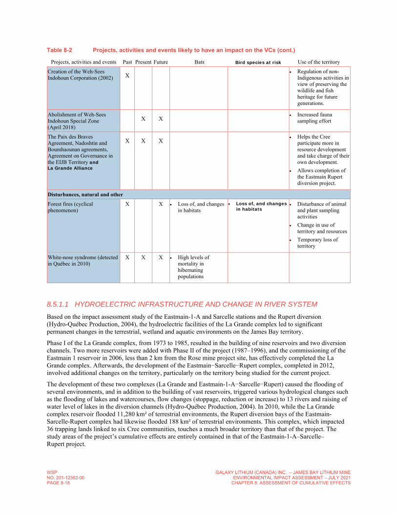
Table 8-2 Projects, activities and events likely to have an impact on the VCs
Projects, activities and events Past Present Future Bats Bird species at risk Use of the territory
Infrastructure and services
Development of the Eastmain community (since 1980)
X Loss of, and changes in habitats
Increased disturbance
Loss of, and changes in habitats
Increased disturbance
Increased fauna sampling effort
Change in use of territory and resources
Loss of territory
Diversion of the Eastmain River (1980)
X X X Loss of and changes in habitats
Increased disturbance
Loss of and changes in habitats
Increased disturbance
Increased fauna sampling effort
Change in use of territory and resources
Loss of territory
Construction of La Grande hydroelectric complex, Phase II (1987–2002) Presence of worker camps
X X X Loss of and changes in habitats
Increased disturbance
Loss of and changes in habitats
Increased disturbance
Increased fauna sampling effort
Change in use of territory and resources
Loss of territory
Construction of Eastmain-1 complexes (2002-2006) Presence of worker camps
X Loss of and changes in habitats
Increased disturbance
Loss of and changes in habitats
Increased disturbance
Temporary increase in fauna sampling effort
Change in use of territory and resources
Loss of territory
Construction of Eastmain-1-A–Sarcelle–Rupert complexes (2007–2010) Presence of worker camps
X Loss of and changes in habitats
Increased disturbance
Loss of and changes in habitats
Increased disturbance
Temporary increase in fauna sampling effort
Change in use of territory and resources
Loss of territory
Operation of the Eastmain-1 (2007) and Eastmain-1-A–Sarcelle–Rupert (2012) (diversion bays and reservoirs) Presence of worker camps
X X X Loss of and changes in habitats
Loss of and changes in habitats
Change in use of territory and resources
Opinaca Airport (construction around 2002, now closed)
X Loss of and changes in habitats
Increased disturbance
Loss of and changes in habitats
Increased disturbance
Change in use of territory and resources
Eleonore Airport (construction in 2014)
X X X Loss of and changes in habitats
Increased disturbance
Loss of and changes in habitats
Increased disturbance
Outside the study area on use of the territory
Eastmain Airport (construction in 1986, rehabilitation in 2013)
X X X Loss of and changes
in habitats
Increased disturbance
Loss of and changes in habitats
Increased disturbance
Opening of territory
Increased fauna sampling effort
Change in use of territory and resources
Nemiscau Airport (construction around 2002) X X X
Loss of and changes in habitats
Increased disturbance
Loss of and changes in habitats
Increased disturbance
Outside the study area on use of the territory

WSP NO. 201-12362-00 PAGE 8-16
GALAXY LITHIUM (CANADA) INC. – JAMES BAY LITHIUM MINEENVIRONMENTAL IMPACT ASSESSMENT – JULY 2021
CHAPTER 8: ASSESSMENT OF CUMULATIVE EFFECTS
Table 8-2 Projects, activities and events likely to have an impact on the VCs (cont.)
Projects, activities and events Past Present Future Bats Bird species at risk Use of the territory
Rehabilitation of Billy-Diamond highway (2005–2018)
X X X Loss of and changes in habitats
Creation of potential movement corridors
Loss of and changes in habitats
Creation of potential movement corridors
Opening of territory
Increased fauna sampling effort
Change in use of territory and resources
Access road to the Eastmain community (construction in 1994, in rehabilitation since 2011)
X X X Loss of, and changes
in habitats
Creation of potential movement corridors
Loss of and changes in habitats
Creation of potential movement corridors
Opening of territory
Construction of the Nemiscau–Eastmain-1 Road (2002) X X X
Loss of and changes in habitats
Creation of potential movement corridors
Loss of and changes in habitats
Creation of potential movement corridors
Opening of territory
Construction of the Muskeg–Eastmain-1 Road (2007) X X X
Loss of and changes in habitats
Creation of potential movement corridors
Loss of and changes in habitats
Creation of potential movement corridors
Opening of territory
Optimization of the Muskeg–Sarcelle Road (2008) X X X
Loss of and changes in habitats
Creation of potential movement corridors
Loss of and changes in habitats
Creation of potential movement corridors
Opening of territory
Optimization of the Sarcelle-Mine Eleonore Road (winter road in 2010, permanent road in 2011)
X X X Loss of and changes
in habitats
Creation of potential movement corridors
Loss of and changes in habitats
Creation of potential movement corridors
Opening of territory
Construction/Optimization of secondary roads X X X
Loss of and changes in habitats
Creation of potential movement corridors
Loss of and changes in habitats
Creation of potential movement corridors
Opening of territory
Truck stop at km 381 (reconstruction in 2013) X X X
Increased disturbance Increased disturbance
Increased fauna sampling effort
Nemaska-Eastmain, Nemaska–La Grande 2, Nemaska-Waskaganish, Eastmain, la Sarcelle and Eleonore transmission lines
X Loss of and changes
in habitats
Creation of potential movement corridors
Loss of and changes in habitats
Creation of potential movement corridors
Opening of territory
Relocation of a 315-kV line and construction of a station (linked to the Rose lithium-tantalum mining project)
X Loss of and changes
in habitats Loss of and changes
in habitats Change in use of
territory and resources
Development of natural resources
Mining exploration activities X X X
Increased disturbance Increased disturbance
Opening of territory
Change in use of territory and resources

GALAXY LITHIUM (CANADA) INC. – JAMES BAY LITHIUM MINE ENVIRONMENTAL IMPACT ASSESSMENT – JULY 2021 CHAPTER 8: ASSESSMENT OF CUMULATIVE EFFECTS
WSPNO. 201-12362-00
PAGE 8-17
Table 8-2 Projects, activities and events likely to have an impact on the VCs (cont.)
Projects, activities and events Past Present Future Bats Bird species at risk Use of the territory
Eleonore Mine X X X
Loss of and changes in habitats
Increased disturbance
Loss of and changes in habitats
Increased disturbance
Outside the study area on use of the territory
Whabouchi Mine (under development) X X
Loss of and changes in habitats
Increased disturbance
Loss of and changes in habitats
Increased disturbance
Outside the study area on use of the territory
Rose lithium-tantalum mining project (under development) X
Loss of and changes in habitats
Increased disturbance
Loss of and changes in habitats
Increased disturbance
Increased fauna sampling effort
Change in use of territory and resources
Use of the territory (non-Indigenous peoples)
Sport hunting and regulations that apply to Zone 22 (hunting and fishing)
X X X Increased disturbance Increased
disturbance Potential disturbance of
hunting, trapping and fishing activities (greatly reduced by regulations in effect)
Granting of rustic shelter leases for sport hunting and fishing (as of 1982)
X X X Potential disturbance of hunting, trapping and fishing activities
Wildlife or protected territory
Granting of a special status under the Act Respecting Threatened or Vulnerable Species
X X X Protection of the four
special-status bat species (occurring and potentially occurring)
Protection of habitats
Protection of occurring or potentially occurring bird species at risk
Implementation of regulatory and legal provisions: Migratory Birds
Convention Act (1985) Migratory Birds
Convention Act (1994) Migratory Birds
Regulations Regulations Amending
the Migratory Birds Regulations (2002)
Environment Quality Act (1972)
Act Respecting The Conservation And Development Of Wildlife (1993)
Federal Policy on Wetland Conservation under the Canadian Environmental Assessment Act (1991)
X X X Protection of habitats
Protection of occurring or potentially occurring bat species at risk
Protection of habitats
Protection of occurring or potentially occurring bird species at risk
Creation of Bird Conservation Regions (BCR) (1999)
X X X Protection of habitats
Protection of occurring or potentially occurring bird species at risk
WSP NO. 201-12362-00 PAGE 8-18
GALAXY LITHIUM (CANADA) INC. – JAMES BAY LITHIUM MINEENVIRONMENTAL IMPACT ASSESSMENT – JULY 2021
CHAPTER 8: ASSESSMENT OF CUMULATIVE EFFECTS
Table 8-2 Projects, activities and events likely to have an impact on the VCs (cont.)
Projects, activities and events Past Present Future Bats Bird species at risk Use of the territory
Creation of the Weh-Sees Indohoun Corporation (2002) X Regulation of non-
Indigenous activities in view of preserving the wildlife and fish heritage for future generations.
Abolishment of Weh-Sees Indohoun Special Zone (April 2018)
X X Increased fauna sampling effort
The Paix des Braves Agreement, Nadoshtin and Boumhaounan agreements, Agreement on Governance in the EIJB Territory and La Grande Alliance
X X X Helps the Cree participate more in resource development and take charge of their own development.
Allows completion of the Eastmain Rupert diversion project.
Disturbances, natural and other
Forest fires (cyclical phenomenon)
X X Loss of, and changes in habitats
Loss of, and changes in habitats
Disturbance of animal and plant sampling activities
Change in use of territory and resources
Temporary loss of territory
White-nose syndrome (detected in Québec in 2010)
X X X High levels of mortality in hibernating populations
8.5.1.1 HYDROELECTRIC INFRASTRUCTURE AND CHANGE IN RIVER SYSTEM
Based on the impact assessment study of the Eastmain-1-A and Sarcelle stations and the Rupert diversion (Hydro-Québec Production, 2004), the hydroelectric facilities of the La Grande complex led to significant permanent changes in the terrestrial, wetland and aquatic environments on the James Bay territory.
Phase I of the La Grande complex, from 1973 to 1985, resulted in the building of nine reservoirs and two diversion channels. Two more reservoirs were added with Phase II of the project (1987–1996), and the commissioning of the Eastmain 1 reservoir in 2006, less than 2 km from the Rose mine project site, has effectively completed the La Grande complex. Afterwards, the development of the Eastmain−Sarcelle−Rupert complex, completed in 2012, involved additional changes on the territory, particularly on the territory being studied for the current project.
The development of these two complexes (La Grande and Eastmain-1-A−Sarcelle−Rupert) caused the flooding of several environments, and in addition to the building of vast reservoirs, triggered various hydrological changes such as the flooding of lakes and watercourses, flow changes (stoppage, reduction or increase) to 13 rivers and raising of water level of lakes in the diversion channels (Hydro-Québec Production, 2004). In 2010, while the La Grande complex reservoir flooded 11,280 km² of terrestrial environments, the Rupert diversion bays of the Eastmain-Sarcelle-Rupert complex had likewise flooded 188 km² of terrestrial environments. This complex, which impacted 36 trapping lands linked to six Cree communities, touches a much broader territory than that of the project. The study areas of the project’s cumulative effects are entirely contained in that of the Eastmain-1-A–Sarcelle–Rupert project.

GALAXY LITHIUM (CANADA) INC. – JAMES BAY LITHIUM MINE ENVIRONMENTAL IMPACT ASSESSMENT – JULY 2021 CHAPTER 8: ASSESSMENT OF CUMULATIVE EFFECTS
WSPNO. 201-12362-00
PAGE 8-19
Table 8-3 shows the proportion of environment types after the completion of the La Grande complex, and Eastmain-1-A–Sarcelle–Rupert project.
Table 8-3 Proportion of environment types after the completion of the La Grande complex and Eastmain-1-A–Sarcelle–Rupert generating stations
Condition of environment
Size (km²)
Aquatic environment Terrestrial environment Total
Natural condition 35,000 (10%)
315,000 (90%)
350,000 (100%)
After La Grande complex 46,280 (13%)
303,720 (87%)
350,000 (100%)
After the Eastmain-1-A-Rupert project 46,468 (13%)
303,532 (87%)
350,000 (100%)
Note: Proportion of environment types in the Eastmain-1-A–Sarcelle–Rupert project study area.
Source: Hydro-Québec Production (2004)
The construction of the Eastmain-Sarcelle-Rupert complex required the erection of many permanent and temporary facilities, namely:
— the Eastmain-1-A and Sarcelle generating stations;
— four dams and 74 dikes, five instream flow release structures incorporated to certain retaining structures for diversion bays (Nemiscau-1, Nemiscau-2, Ruisseau-Arques, Lemare and LR-51-52);
— one spillway and eight hydraulic structures on the Rupert River;
— a 2.9-km transfer tunnel between the upstream and downstream diversion bays and nine channels with a total length of approximately 7 km;
— Two 315-kV transmission lines (one 101-km line between the la Sarcelle and Eastmain-1 power plants and one 0.5-km line between the Eastmain-1 and Eastmain 1-A stations);
— a permanent road network (131 km) and some temporary construction roads;
— six camps for workers: two used previously during the construction of the Eastmain-1 facility, and four new ones (Hydro-Québec Production, 2012).
8.5.1.2 ROAD TRANSPORTATION AND POWER TRANSMISSION INFRASTRUCTURE
Prior to 1974, the road network was concentrated in the southern part of James Bay. With the building of the La Grande complex to the north and forest operations to the south, it has increased significantly in the James Bay territory, playing a key role in the gradual opening up of the region (Hydro-Québec Production, 2004).
The transportation infrastructure in the study areas of the project’s cumulative effects was especially marked by the rehabilitation of the Billy-Diamond highway (620-km long). Built in 1971 and opened to the public in 1986, this road extends from Matagami to Radisson, and provides access to the Robert-Bourassa generating station. It has been undergoing reconstruction since 2005. As shown in Table 8-4, other works are underway or upcoming in 2018.
Then, in 1993, came the construction of the Route du Nord; the latter is a gravel road linking Chibougamau to the Billy-Diamond highway and is located just south of the cumulative effect study areas. In 1994, the access road to the Eastmain Cree Community took shape. This road joins the Billy-Diamond highway, covering 102.4 km. It has been in reconstruction since 2011 to improve the intersection with the Billy-Diamond highway, refill and fix deformations, excavate ditches, bypass km 38, pave km 0 to 30, and complete new surfacing treatment. A second 30-km section will be paved in upcoming years (central). Toward 2002, the road connecting Nemiscau to Eastmain-1 was built and then, in 2007, came the road linking the Muskeg cogeneration plant to Eastmain-1. Expansion of the road leading to La Sarcelle occurred in the same period.

WSP NO. 201-12362-00 PAGE 8-20
GALAXY LITHIUM (CANADA) INC. – JAMES BAY LITHIUM MINEENVIRONMENTAL IMPACT ASSESSMENT – JULY 2021
CHAPTER 8: ASSESSMENT OF CUMULATIVE EFFECTS
Table 8-4 Situation of reconstruction on the Billy-Diamond highway
Kilometres targeted by the work Date of work Nature of work Constraints
Section included in the study areas
Km 38, Waswanipi River Bridge
May 28 to August 16, 2018 Bridge refurbishment Maximum load (70 T) Potential traffic
No
Km 144 to 200 May 28 to October 30, 2018
Replacement of culverts, pavement rehabilitation and pulverization work. Other work underway.
Maximum load (62 T) Single-lane traffic Alternating traffic controlled by lights Slowdowns
No
Km 306, Pontax I Bridge
June 26 to August 10, 2018 Bridge refurbishment Maximum load (62 T) Single-lane traffic Alternating traffic controlled by lights Slowdowns
Bats: Yes Use of territory: No
Km 312, Pontax II Bridge
July 26 to August 10, 2018 Bridge refurbishment Maximum load (62 T) Single-lane traffic Alternating traffic controlled by lights Slowdowns
Bats: Yes Use of territory: No
Km 380 to 480 August 13 to 24, 2018 Resurfacing of shoulders Single-lane traffic Bats: Yes Use of territory: Km 380 to 428
Km 0 to 620 July 23 to August 13, 2018 Pavement marking Slowdown Bats: Km 244 to 530 Use of territory: Km 333 to 428
Source: SDBJ (2018).
In addition, many access roads to hydroelectric facilities (substations, power plants, dikes, dams, transmission line rights-of-ways, borrow pits, etc.) form a discontinuous network of several hundred kilometres within the James Bay territory affected by hydroelectric development (Hydro-Québec Production, 2004).
Three airports are also found in the study area for the social environment. That of Eastman is located 100 km from the project, while that of Nemiscau is located farther than 85 km. Although now closed, the Opinaca airport is within about 30 km of the project site. It served mainly construction workers of the Eastmain-1 and Eastmain-1-A–Rupert project and those of Les Mines Opinaca until an Éléonore airport was constructed near it. This airport is located approximately 85 km northeast of the project site. Since 2014, a permanent road has also provided access to the Opinaca mine from the end of the road leading to the Sarcelle generating station.
The territory affected by the Eastmain-1-A–Rupert hydroelectric project already had seven high-voltage power lines in 2004 (six 735-kV lines and one 450-kV direct current line). Connected to this network, several different voltages supply various consumption points, such as workers’ camps, villages and mines. They cover a total of 6,508 km, to which are added, for the Eastmain-1-A–Rupert project, two lines at 315 kV (totalling 160 km), a temporary line at 69 kV (42 km) and distribution lines to temporary camps for workers and permanent structures (60 km). (Hydro-Québec Production, 2004) A 315-kV line between the Eastmain-1 and Eastmain-1-A switching yards, and between the Sarcelle and Eastmain-1 substations was constructed in 2011 (Hydro-Québec Production, 2017). A 315-kV transmission line crossing the Rose mining project site will be moved to allow completion of the project.
Previously powered by diesel generators, the truck stop at km 381 is now connected to the Hydro-Québec network by a 25 kV power line. Studies are underway to assess the electricity demand for the James Bay Lithium Mine project. GLCI plans to connect to the Hydro-Québec power distribution system via a 69-kV line. Depending on the route set by Hydro-Québec, this connection could require up to 11 km of additional power lines.
GALAXY LITHIUM (CANADA) INC. – JAMES BAY LITHIUM MINE ENVIRONMENTAL IMPACT ASSESSMENT – JULY 2021 CHAPTER 8: ASSESSMENT OF CUMULATIVE EFFECTS
WSPNO. 201-12362-00
PAGE 8-21
8.5.2 DEVELOPMENT OF NATURAL RESOURCES
This theme covers various forest and mining activities, past, present and future.
8.5.2.1 FORESTRY ACTIVITIES
Since 1980, forest clearcuts done in the study area were associated primarily with the completion of various projects. Cuts were done for the purposes of borrow pits (sandpits or quarries) to build road right-of-ways and power transmission lines, to prepare construction sites, and to set up worker camps. Several headrace areas were also deforested prior to flooding. However, these cuts are not considered entirely to be forestry activities since they were related to the various projects listed above and had been considered.
No commercial timber harvesting was done in the cumulative effect study areas.
8.5.2.2 MINING ACTIVITIES
Since 2007, several mining exploration activities have been done in the territory and, more specifically in the cumulative effect study areas. In 2018, numerous mining exploration rights are pending near the GLCI mining project site. However, little information is available and accessible regarding the mining exploration activities (MERN, 2016).
One mine is operating and two others are being developed within a 110-km radius of the project. Les Opinaca Mines, a wholly owned subsidiary of Goldcorp Inc., operates the Éléonore mine, an underground gold deposit near the Opinaca Reservoir. Opened in 2011, this mine is located 85 km northeast of the project. It is accessible year-round via an access road roughly 60 km long and connected to the north end of the access road to Hydro-Québec's Sarcelle generating station. According to the 2014 Goldcorp Annual Report, it was expected to be one of the largest gold mines in Canada in 2018, with a capacity of 7,000 t of ore daily (Goldcorp, 2015).
Projects under development include the Rose lithium-tantalum mining project (Critical Elements Corporation), located 60 km southeast of the project site. It will be an open-pit spodumene mine with a targeted production rate of 4,600 t/day. Operation of this mine is expected to span 19 years, for a total project duration of roughly 22 years. The Whabouchi mining project (Nemaska Lithium) is located more than 100 km southeast of the project. It has been in development since 2016 and will exploit a spodumene deposit. This mine is currently in the preproduction stage.
In addition, numerous deposits are located outside the cumulative effect study areas. Indeed, close to the Whabouchi mining project, there are several less advanced projects, primarily under study at the exploration stage, targeting spodumene-bearing pegmatite on or near the surface (MRNF, 2011; Noka Resources, 2016). So other lithium mining projects could see light of day in the Nemiscau-Eastmain sector.
There is also the Troilus mine, 280 km southeast, which could soon return to operation; it ceased activities in 2010, after some 15 years of open-pit mining of copper, gold and silver. In addition, about 15 mines are located further from the project, between 250 km and 350 km away.
8.5.3 USE OF THE TERRITORY BY NON-INDIGENOUS PEOPLE
This theme covers sport fishing and hunting activities and the associated recreation infrastructure. These involve primarily use of the territory by non-Indigenous people.
Since 1980, development of the Billy-Diamond highway has resulted in increased recreational activities within the territory (tourism, sport fishing and hunting), especially since the opening of the Billy-Diamond highway to non-Indigenous people in 1986. However, these activities have remained concentrated primarily in the southern portion of James Bay and east of the Robert-Bourassa hydroelectric facilities. In 1991, a follow-up done to evaluate the impact of sport fishing and hunting on animal populations recorded nearly 11,000 vehicles at the entrance to the Billy-Diamond highway (Hydro-Québec Production, 2001). Traffic statistics compiled by the SDBJ showed 56,139 recorded trips on the Billy-Diamond highway in 2014 and 55,632 in 2017 (personal communication with the SDBJ, 2018).
WSP NO. 201-12362-00 PAGE 8-22
GALAXY LITHIUM (CANADA) INC. – JAMES BAY LITHIUM MINEENVIRONMENTAL IMPACT ASSESSMENT – JULY 2021
CHAPTER 8: ASSESSMENT OF CUMULATIVE EFFECTS
Some activities, such as snaring of hares, trapping, and fishing of sturgeon and whitefish, are reserved exclusively for beneficiaries of the JBNQA throughout the territory. Hunters and fishers who are not JBNQA beneficiaries are subject to the laws and regulation in force in the territory and must hold a sport hunting or fishing licence from the Québec Government, applicable on all Category III land. Before April 1, 2018, and since 2002, different regulations applied to the hunting sectors of Weh-Sees Indohoun (WSI) and Eastmain, in which the project is located. To hunt and fish on Category I and II lands, authorization must have been issued by the Band Councils concerned.
In the past, recreational hunting and fishing activities in the project sector were practised mostly by Hydro-Québec workers involved in building the Eastmain-1-A and Sarcelle hydroelectric projects, and the Rupert River diversion. However, there are far fewer of these workers since construction work associated with the Eastmain-Sarcelle-Rupert complex finished, and the MFFP believes that the vast majority of these workers have left the territory. However, according to the Cree users interviewed during the consultation sessions in 2018, some non-natives use the territory for moose hunting and fishing. These activities are practiced mainly along the Billy-Diamond highway, particularly at the intersection of the Eastmain River and on certain lakes near the highway.
According to the Québec Original website (Tourisme Québec), there are three outfitters within a 150-km radius of the project site, but it is possible that some small Cree outfitters were not recorded. Some families have opened outfitter’s camps, or plan to do so to offer guided hiking, hunting and fishing trips (Goldcorp, not dated). However, little information is available on this matter. During the 2017–2018 consultation conducted for this EIA, a very preliminary outfitting project was mentioned by users of trapline VC35. This trapline is located northeast of the project, on the north shore of the Eastmain River.
According to the EIA of the Whabouchi mining project (Nemaska Lithium, 2013), a series of land rights were issued to non-Indigenous people by MERN in the Whabouchi mining project. About 10 km north of the project site, there is a vacation lot lease. Including this lease, 16 vacation lot leases are located within the borders of the study area of the cumulative effects on use of the territory. (Map 8-2) Some 20 km northeast of the study area there is a vacation lot lease for rustic shelters. Including this lease, there are three vacation lot leases for rustic shelters in the study area.
8.5.4 WILDLIFE OR PROTECTED TERRITORIES
This theme covers the territories with special protection status, as well as the management, conservation or recovery plans by the governments of Québec and Canada for the protection and management of wildlife species and habitats.
8.5.4.1 WILDLIFE RESERVES, SANCTUARIES AND BIODIVERSITY RESERVES
No wildlife reserve is located within the study areas of cumulative effects.
On the other hand, biodiversity reserves are planned within the JBNQA territory. The primary objective of these planned reserves is to maintain biodiversity in the terrestrial environment. For each biodiversity reserve planned, a conservation plan is developed. Within biodiversity reserves, mining activities and forest management are prohibited. The end date of temporary protection varies from one reserve to the next, and ranges between 2018 and 2025.
The planned Paakumshumwaau-Maatuskaau biodiversity reserve follows a proposal by the Cree community of Wemindji who want to preserve the watersheds of the Vieux-Comptoir and Des Peupliers rivers, a territory that has traditionally been used by the Cree Nation for over 3,500 years (Gouvernement du Québec, 2010). Located roughly 32.5 km north of the Cree village of Eastmain, the planned reserve is located outside the study area of the cumulative effects of land use, but falls within that for bats. The temporary protection of the reserve is slated to end on June 11, 2020. However, the government intends to protect this territory permanently. If all steps leading to the permanent status being granted are not completed by June 11, 2020, the necessary steps will be taken to extend the provisional protection status in compliance with the provisions of the Natural Heritage Conservation Act (CQLR, chapter C-61.01).
GALAXY LITHIUM (CANADA) INC. – JAMES BAY LITHIUM MINE ENVIRONMENTAL IMPACT ASSESSMENT – JULY 2021 CHAPTER 8: ASSESSMENT OF CUMULATIVE EFFECTS
WSPNO. 201-12362-00
PAGE 8-23
The planned Waskaganish biodiversity reserve is approximately 40 km east of the Cree village of Waskaganish. It covers an area of 1,062.7 km2 and includes five islands located at the Pontax River mouth and represent habitats of great ecological interest because they are at the transition between salt and fresh water. It also includes ecotones on the edge of Rupert Bay, which are likely to be home to special flora and fauna.
The planned Chisesaakahikan-et-de-la-rivière-Broadback biodiversity reserve is approximately 150 km northeast of the town of Matagami. This reserve covers 4,977.9 km2, and it was originally created to ensure that biodiversity and associated natural and cultural resources are protected and maintained.
These three proposed biodiversity reserves are outside the cumulative effects study area for land use but are included within the area for bats.
At the time of the summer 2018 public consultations, Eastmain community representatives wished to propose that the Québec government recognize a significant portion of RE2 as a protected area under the Natural Heritage Conservation Act.
8.5.4.2 OTHER PROTECTION
GRANTING OF A SPECIAL STATUS
On December 17, 2014, at the recommendation of COSEWIC, the Government of Canada added three species of bats to the List of Wildlife Species at Risk in Canada (Appendix I Species at Risk Act): little brown bats (Myotis lucifugus), northern long-eared bats (Myotis septentrionalis) and tri-coloured bats (Perimyotis subflavus). These three bat species have been designated as “endangered” because of the imminent threat to their survival posed by white-nose syndrome (Gouvernement du Canada, 2014). Schedule I of the Species at Risk Act includes the eight bird species selected. The Short-eared Owl, Red-necked Phalarope, Rusty Blackbird and Yellow Rail are listed as “Special Concern” and the Common Nighthawk, Bank Swallow, Olive-sided Flycatcher and Canada Warbler are listed as “Threatened” (Government of Canada, 2021).
In Québec the eastern red bat appears on the list of wildlife species likely to be designated as threatened or vulnerable under the Act respecting threatened or vulnerable species (Gouvernement du Québec, 2006). However, it should be noted that there are no specific protective measures for the eastern red bat, either in Québec or Canada. Concerning special-status birds, the Yellow Rail is “threatened” while the Common Nighthawk, Short-eared Owl, Olive-sided Flycatcher, and Canada Warbler are “likely to be designated as threatened or vulnerable” (MFFP, 2021).
LAWS AND REGULATIONS
The implementation of regulatory and legal provisions contributes to the protection of wildlife species and their habitats. These include:
— Migratory Birds Convention Act, 1985 (replaced by the Migratory Birds Convention Act, 1994); — Migratory Birds Regulations; — Regulation Amending the Migratory Birds Regulations (2002); — Environment Quality Act (1972); — Act Respecting The Conservation And Development Of Wildlife (1993); — Federal Policy on Wetland Conservation under the Canadian Environmental Assessment Act (1991).
BIRD CONSERVATION REGION
The North American Bird Conservation Initiative (NABCI) was founded in 1999 to address concerns about the decline of many once-common species. NABCI partners Canada, Mexico, and the United States have identified “ecoregions” based on common and appropriate ecological principles for birds to plan, implement, and evaluate conservation actions across North America. Bird Conservation Regions (BCRs) are the baseline areas from which biological planning is conducted to develop bird conservation strategies in North America. Recommended actions in BCR strategies and conservation priorities are used to develop guidelines and beneficial management practices that promote compliance with the Migratory Birds Convention Act, 1994. Canada has 12 BCRs, with several divided into sub-regions (Government of Canada, 2017).
WSP NO. 201-12362-00 PAGE 8-24
GALAXY LITHIUM (CANADA) INC. – JAMES BAY LITHIUM MINEENVIRONMENTAL IMPACT ASSESSMENT – JULY 2021
CHAPTER 8: ASSESSMENT OF CUMULATIVE EFFECTS
EEYOU MARINE REGION
Commonly known as the Cree Offshore Agreement, the Eeyou Marine Region Land Claims Agreement is the product of a decade of negotiations concerning the rights and obligations of the Cree and the Government of Canada in the Eeyou Itschee offshore region. This marine region, traditionally occupied and used by the Cree, is known as the Eeyou Marine Region.
This treaty recognizes ownership and other rights in some sectors off the coast. It also constitutes a recognition by the Cree of the application of certain Canadian laws in these sectors. All Cree appearing in the register prepared by the JBNQA are automatically entered as beneficiaries of this agreement, whether they live on the coast or inland.
WEH-SEES INDOHOUN
In October 2003, the WSI was implemented by the Québec Government, Hydro-Québec and the Grand Council of the Cree under the Boumhounan and Nadoshtin agreements. The objective was to create a special hunting and fishing zone and apply specific sport hunting and fishing measures during construction of the Eastmain-1 and Eastmain-1-A–Sarcelle–Rupert hydroelectric projects.
Starting in 2015, this area was managed by the WSI subcommittee, which was made up of representatives of the Cree Nation government, Cree communities included in this area (Nemaska, Waskaganish, Wemindji, Eastmain, Mistissini), the Cree Trapper’s Association, the MFFP as well as the Hunting, Fishing and Trapping Coordinating Committee (WSI, not dated). The management measures implemented in the WSI zone, such as access rights and the fish catch registration system, ensured the capture of important information for supervising the health and exploitation of populations following increased opening of the territory. With the aid of the information collected, management measures were periodically reviewed to ensure their effectiveness (WSI, not dated).
The WSI zone was made up of two sport hunting and fishing sectors: the Weh-Sees Indohoun sector and the Eastmain sector. While moose hunting was prohibited at all times in the Eastmain sector, it was authorized (with some restrictions in the WSI sector. Having a total area of 16,656 km², these two sectors included Category I and II lands of the Nemaska Cree Nation, and Category III lands (WSI, not dated).
The MFFP officially abolished the WSI zone in the spring of 2018, since most workers on the large Hydro-Québec hydroelectric development projects had left the territory. According to information amassed since 2003, this abolition will not affect the sustainability of wildlife resources (MFFP, 2018).
Among the most notable changes arising from the abolition of the WSI zone is that sport fishers are no longer required to obtain an access right to fish in the rivers and bodies of water located within this zone. They are nonetheless required to have a fishing licence from the Québec government, and to respect catch and possession limits and the regulations in force, depending on the sector. In regard to sport hunting, hunters who are not beneficiaries of the JBNQA are now subject to the laws and regulations in force in this territory and must hold a hunting licence from the Québec government.
PAIX DES BRAVES, NADOSHTIN AND BOUMHAOUNAN AGREEMENTS, AGREEMENT ON GOVERNANCE IN THE EIJB TERRITORY AND LA GRANDE ALLIANCE
In 2002, Québec and the Cree signed the Agreement concerning a new relationship between the Gouvernement du Québec and the Crees of Québec. The Paix des Braves established the modalities of a forest regime adapted to the James Bay territory. Specific modalities for logging were put in place, such as the implementation of block cuttings. The Nadoshtin and Boumhounan agreements created, respectively, in the Eastmain-1 and Eastmain-1-A-Rupert projects, mechanisms to manage road access and the use of fish and wildlife resources (by the WSI) as well as to ensure that the Cree have opportunities for contracts and to promote their training and hiring (Hydro-Québec Production, 2004).
The Agreement on Governance in the Eeyou Istchee James Bay Territory was signed by the Cree of Eeyou Istchee and the Québec Government in July 2012. The EIJJBRG aims to harmonize relations between the Jamesians and the Cree in the area of governance of the EIJB territory, and to enable the two communities to contribute significantly to the prosperity of the territory (Chapter 6).
GALAXY LITHIUM (CANADA) INC. – JAMES BAY LITHIUM MINE ENVIRONMENTAL IMPACT ASSESSMENT – JULY 2021 CHAPTER 8: ASSESSMENT OF CUMULATIVE EFFECTS
WSPNO. 201-12362-00
PAGE 8-25
In the spirit of the Paix des Braves, “La Grande Alliance” is a Memorandum of Understanding for collaboration and consolidation of socio-economic ties between the Cree Nation and Quebec government to connect, develop and protect the territory”. Its objective is to build a promising project for the strategic, predictable and sustainable development of the territory to:
— guarantee the long-term protection of the territory (protected areas); — improve the standard of living (housing, electricity and internet); — extend the transport network (rail, road, port and airport).
This project is proposed by the Cree community and will make it possible for First Nations, governments and private companies to work together to develop society through natural resources (La Grande Alliance, 2021).
8.5.5 DISTURBANCES, NATURAL AND OTHER
This theme covers natural disturbances that may have affected one or more VCs; in the present case, these are forest fires and the white-nose syndrome.
8.5.5.1 FOREST FIRES
As mentioned in the EIA of the Eastmain-1-A–Rupert project (Hydro-Québec Production, 2004), forest fires occasionally affect Cree traplines and terrestrial ecosystems. Areas for the study of cumulative effects are located entirely within northern zones protected by SOPFEU.
A number fires have occurred in the James Bay territory since the 1970s (RNCan, 2017). Between 1975 and 2003, an area of 5,933,272 ha was destroyed by fire in the James Bay territory (Nemaska Lithium, 2013). In all time periods, lightning has proved to be the primary cause of forest fires.
In June 2013, the largest forest fire in the province’s history occurred at James Bay (2,196,455 ha). That fire mainly affected land belonging to the Eastmain Cree community, forcing the evacuation of some 350 people from the community (Radio-Canada, 2013). SOPFEU does not generally intervene north of the 51st parallel, except when a fire threatens persons or property deemed essential for public safety. This was the case for Eastmain in 2013. At this time, the km 381 truck stop caught fire.
Some 68 fires occurred within a radius of 110 km around the project site between 1980 and 2016. Among the largest fires to occur within the territory were those of 2013 (584,000 ha), 2005 (208,708 ha), 2006 (44,026 ha) and 2010 (35,122 ha).
8.5.5.2 WHITE-NOSE SYNDROME
The WNS is a fungal infection affecting bats, particularly cave-dwelling species, in northeastern North America, including Québec. It is characterized by massive bat mortality, often associated with the observation of a whitish fungal growth on certain parts of the body, mainly the snout, of infected bats (MFFP, 2016b; MFFP, 2017).
Discovered during the winter of 2006–2007 in Howe Cave in the State of New York, WNS reached Ontario and Québec in 2010. Since WNS is spreading with great rapidity, at about 300 km/year, the affected areas and the number of threatened bats is increasing steadily year by year. Today, WNS thus represents the principal threat to bat populations in northeastern North America.

WSP NO. 201-12362-00 PAGE 8-26
GALAXY LITHIUM (CANADA) INC. – JAMES BAY LITHIUM MINEENVIRONMENTAL IMPACT ASSESSMENT – JULY 2021
CHAPTER 8: ASSESSMENT OF CUMULATIVE EFFECTS
8.6 ANALYSIS OF CUMULATIVE EFFECTS ON VCS
8.6.1 BATS
8.6.1.1 PROJECTS, ACTIONS OR EVENTS
Past, current and future projects, actions or events that may have had or could have an effect on bats (Chiroptera) are set out in table 8-2. The main elements that may have affected or could affect the evolution of bat populations are discussed below.
Aside from wind energy projects, which may cause bat mortality directly through collision or barotrauma (Arnett and coll., 2008; Baerwald and coll., 2008), the potential effects of anthropogenic development projects on bat populations mainly involve habitat loss (Tremblay and Jutras, 2010). Human activity can also cause disturbance to individuals, particularly through emissions of light, noise and vibration (Bunkley and coll., 2015; EC, 2015; Stone and coll., 2015).
There is no existing wind farm within the spatial boundaries defined for the assessment of cumulative effects on bats and, based on available information, no wind energy project is currently planned for this area.
On the other hand, development of anthropogenic activity in the region has over time led to habitat loss for bats, mainly through deforestation of mature forest stands and encroachment on wetlands and hydrous environments (watercourses). This is particularly the case for mining activities, hydroelectricity projects, road and airport infrastructure, and energy transmission lines. To a lesser extent, hunting and the opening of the territory to human activity contribute to an increase in sources of disturbance for bats (light, noise, vibrations). Moreover, hydroelectricity projects such as the La Grande complex have also led to habitat loss through artificial flooding.
In parallel with the development of these anthropogenic activities, particularly during recent decades, measures have been taken to ensure the protection and management of wildlife species and natural habitats. Laws and regulations formulated for these purposes have gradually been integrated into anthropogenic development activities. This is particularly the case for conservation plans, the designation of conservation areas, and the creation of parks and reserves. Some of these activities are potential sources of positive effects for bat populations.
In regard to natural disturbances, forest fires constitute a source of habitat loss for bats. These fires, generally caused by lightning, shape the region’s forest dynamics (Nemaska Lithium, 2013). Several major forest fires have occurred in the study area, particularly the fire of 2013, which affected close to 15% of its area. The loss of large-diameter trees and snags in mature forest environments, which bats prefer, has a negative effect on the bat VC.
As mentioned earlier, one of the major sources of impact for bat populations is WNS, which was first detected in Québec in 2010 (MFFP, 2017). This syndrome is spreading rapidly and is now present in over 15 northeastern U.S. states, its impact demonstrated by the fact that over 1 million bats are estimated to have succumbed to the disease since its discovery (MFFP, 2016a). Most North American bat species may be affected by WNS. However, bats of the genus Myotis, the big brown bat and the tri-coloured bat have been particularly badly hit in the northeastern United States and Ontario (MFFP, 2016b). Since the winter of 2010–2011, the first observations of WNS have been recorded in bat populations of Québec, including those of the Nord-du-Québec region (MFFP, 2017). Although the significance of its effect on bat populations in the region has not yet been assessed with precision, the disease has so far caused an overall decline of 94% in known numbers of Myotis bats hibernating in Nova Scotia, New Brunswick, Ontario and Québec (EC, 2015). WNS is therefore a major event in terms of its cumulative effects.

GALAXY LITHIUM (CANADA) INC. – JAMES BAY LITHIUM MINE ENVIRONMENTAL IMPACT ASSESSMENT – JULY 2021 CHAPTER 8: ASSESSMENT OF CUMULATIVE EFFECTS
WSPNO. 201-12362-00
PAGE 8-27
8.6.1.2 BASELINE CONDITION
There is little data available to provide a relevant baseline condition for bats in the region. Since the earliest data concerning bat populations in Northern Québec date from 2003, that year has been taken as the past temporal boundary for the assessment of the project’s cumulative effects on the bat CV. According to the latest figures published by the Réseau in its CHIROPS newsletter (Jutras and Vasseur, 2011), bats of the genus Myotis accounted for 5 of the 7 records collected in the Nord-du-Québec region in 2003 (71.4%). The two other species identified in this region were the hoary bat (1 record, 14.3%) and the big brown bat (1 record, 14.3%). Only the eastern red bat was not identified in the 2003 survey.
In regard to data obtained during the acoustic survey conducted by WSP in 2017, the survey confirmed the presence of bats of the genus Myotis (4.41% of records), the big brown bat (1.47% of records) and the hoary bat (86.7% of records), for a total of 68 passes recorded. Considering the survey effort (261 station-nights), few passes were recorded for the various bat species (section 6.3.6.2).
8.6.1.3 HISTORICAL TRENDS
Information on bats in the Nord-du-Québec region is very scarce and fragmentary, making it difficult to define historical trends concerning populations of the various species of bats. Data from the Réseau provide annual monitoring between 2003 and 2009, but the numbers of observations are too small to allow a useful comparison of relative numbers from one year to another. However, the presence of species identified by the Réseau, namely bats of the genus Myotis, the hoary bat and the big brown bat, was confirmed in almost every year during this period, except for 2004 and 2008, when the big brown bat was absent from records collected (Jutras and Vasseur, 2011). Moreover, the presence of these species was confirmed during the 2017 acoustic survey.
The main impact on bat populations is undoubtedly the appearance of WNS, which was first identified in Québec in 2010 (MFFP, 2016a) and has been observed since the winter of 2010–2011 in the Nord-du-Québec region as far as Chibougamau (MFFP, 2016b). As mentioned earlier, WNS has caused significant mortality (94% of known numbers) in resident bat populations, particularly those of the genus Myotis.
Since 2003, the effects of anthropogenic development projects on bat populations have largely come as a result of habitat loss (Tremblay and Jutras, 2010). Whether infrastructure and services projects (e.g., the Eastmain 1 reservoir, and the Nemiscau and Opinaca airports) or mining projects (Éléonore and Whabouchi), all such projects entail deforestation and encroachment on wetlands and hydrous environments (watercourses), which constitute potential sources of habitat loss and modification for bats. These projects are also associated with the creation of roads and/or energy transmission corridors that also contribute to habitat loss, but which can also be sources of positive effects for bats. This is because, as they travel from one site to another, bats generally use linear gaps in the forest structure for guidance, such as road or power line rights-of-way (Grindal and Brigham, 1998; Henderson and Broders, 2008).
Deforestation activities associated with anthropogenic development projects constitute the only sources of forest operations within the spatial boundaries considered for this CV. Like forest fires, deforestation activities also contribute to the fragmentation of forest habitats and result in the creation of linear elements that are used by certain species of bats (EC, 2015).
In 2012, recognizing the massive mortality of bats caused by WNS, COSEWIC recommended that three bat species be classified “endangered”: the tricoloured bat, the little brown myotis and the northern myotis. This status was reviewed and confirmed in November 2013 (COSEWIC, 2014), and these species were added to Schedule 1 of the SARA on December 17, 2014 (COSEWIC, 2016; Gouvernement du Canada, 2014). The little brown myotis and the northern myotis had not previously been granted any special provincial or federal status.
In conclusion, because of the lack of specific data on regional population dynamics, there is no clear trend for the study area under consideration. It can therefore only be supposed that the population is suffering a decline similar to that in the rest of Québec, because the main cause of this decline seems to be WNS.

WSP NO. 201-12362-00 PAGE 8-28
GALAXY LITHIUM (CANADA) INC. – JAMES BAY LITHIUM MINEENVIRONMENTAL IMPACT ASSESSMENT – JULY 2021
CHAPTER 8: ASSESSMENT OF CUMULATIVE EFFECTS
8.6.1.4 CUMULATIVE EFFECTS
The main threats facing bats are habitat loss, wind energy developments and WNS (Tremblay and Jutras, 2010). Given the absence of wind energy projects in the region, the potential negative effects of human development projects essentially involve habitat loss.
The assessment of the James Bay Lithium Mine project’s impact in terms of habitat loss and disturbance for bat populations concluded that the residual effect is of minor significance, even considering the fact that bats of the genus Myotis and the hoary bat are species with a special status. Also, because of forest fires, most of the natural environments that will be affected by the project are characterized by the absence or virtual absence of a tree stratum. These environments are therefore not the most propitious for the bat species identified in the study area, which are essentially arboreal. In addition, considering the planned remediation activities, habitat loss is not likely to compromise the integrity of local populations. Moreover, if deforestation is not carried out during the breeding season, the fact that there are sufficient replacement habitats of similar quality in the region means that the effect of this habitat loss will not prove significant for bat populations.
Past, present and future actions likely to lead to habitat loss in the area include projects leading to the disappearance of mature forest stands or wetlands and hydrous environments, or potential travel corridors (encased valleys, lakeshores, watercourses, etc.). Essentially, these are represented by the creation of the Eastmain 1 reservoir and the Eastmain-Sarcelle-Rupert complex, the Nemiscau and Opinaca airports, the Whabouchi and Éléonore mining projects and the roads and energy transmission lines associated with them. Their effects are nevertheless limited in terms of surface area in view of the spatial boundaries considered for the assessment of cumulative effects. Moreover, the presence of a portion of the territory belonging to three planned biodiversity reserves in the study area for the cumulative effects assessment represents a positive impact for bats and birds through the increase in conservation areas, including their habitats of interest.
Forest fires have caused, and will likely continue to cause, substantial habitat loss inside the spatial and temporal boundaries considered, particularly with regard to forest stands. Thus, when compared with losses caused by forest fires, the anticipated habitat loss caused by the present project is very minor.
Again, in connection with natural disturbances, the appearance of WNS has already caused and will probably continue to cause substantial mortality in resident bat populations, particularly in species of the genus Myotis. Because the fungus attacks bats during the hibernation period, they die of exhaustion before winter’s end (Chauve-souris.ca, 2018). Very little data is available regarding the location of hibernation sites in the Nord-du-Québec region. The northernmost known hibernation site lies a little to the north of Lebel-sur-Quévillon. Nevertheless, since bats can cover hundreds of kilometres to reach their hibernation site, the risk that species of hibernating bats identified in the study area will be affected by WNS during the hibernation period is high, which could cause a marked fall in the number of bats present in the study area. As a guide, in hibernation sites in the United States, the recorded decline in the species that are present in Québec stands at 91% for the little brown myotis (Myotis lucifugus), 98% for the northern myotis (Myotis septentrionalis), 41% for the big brown bat (Eptesicus fuscus), 75% for the tri-coloured bat (Perimyotis subflavus) and 12% for the eastern small-footed myotis (Myotis leibii) (Chauve-souris.ca, 2018). Consequently, the effects of the white-nose syndrome constitute heavy pressure on bats of the genus Myotis within the spatial and temporal boundaries considered.
Finally, the anticipated cumulative effects of the project on bats are judged to be negligible and will consist mainly in a slight increase in disturbance of bats near the site, as well as occasional loss and modification of the habitat. For this reason, the cumulative effect on bats is deemed to be of low magnitude, local scope and long duration. The importance of this cumulative effect is definitively deemed to be minor. The project will therefore not entail substantial cumulative effects on bats (chiroptera).
8.6.1.5 MITIGATION MEASURES AND FOLLOW-UP
No additional mitigation measures or additional environmental follow-up beyond those proposed in the specific environmental assessment are required for this component.

GALAXY LITHIUM (CANADA) INC. – JAMES BAY LITHIUM MINE ENVIRONMENTAL IMPACT ASSESSMENT – JULY 2021 CHAPTER 8: ASSESSMENT OF CUMULATIVE EFFECTS
WSPNO. 201-12362-00
PAGE 8-29
8.6.2 BIRD SPECIES AT RISK
8.6.2.1 PROJECTS, ACTIONS OR EVENTS
Table 8-2 provides an inventory of past, current and future projects, actions or events that may, or could, have an effect on bird species at risk. These are essentially the same projects, actions or events that could affect bats. The main elements that may or could have a cumulative effect on changes in the populations of bird species at risk are discussed below.
Most projects related to new linear and non-linear infrastructure and its extension result in habitat changes and losses and disturbance to terrestrial birds and consequently to species at risk. This is particularly the case for projects involving road and secondary road construction, hydroelectric complex construction and substation and power line construction and relocation (building construction, linear structures, land surface flooding and human presence). For example, the Eastmain-1-A/Rupert project resulted in a decrease in passerine bird breeding pairs and a permanent loss of terrestrial and wetland environments at the local level (Hydro-Québec Production, 2004). However, the presence of reservoirs, such as Eastmain-1 and Opinaca, may benefit other species such as waterfowl.
Some bird species are sensitive to the presence of roads (traffic, noise, etc.). Furthermore, vehicles on these roads can cause fatal collisions (Villard et al., 2012). The main roads in the study area considered for cumulative effects are the Billy-Diamond highway, the access road to the community of Eastmain, the Nemiscau-Eastmain-1 road, the Muskeg-Eastmain-1 road, the Muskeg-Sarcelle road, the Sarcelle-Mine Éléonore road, as well as the various secondary roads. Other infrastructure can also cause bird disturbance and even mortality, such as airports and their associated airstrips.
Recreational use of the area, i.e., by outfitters, hunting and fishing activities and the granting of leases for rustic or resort shelters, may have resulted in a loss of habitat and an increase in disturbance for certain bird species that nest there. Note, however, that recreational land use is relatively low in the study area. The creation of a network of permanent corridors, associated with access roads to these various facilities, may also have a negative effect on certain migratory bird species by increasing nest predation and disturbance of certain species (Askins, 1994; Jordan, 2000). However, the change in habitat through the creation of roads or trails may benefit some species associated with open areas. Waterfowl hunting and fishing (due to human presence on bodies of water) are the main elements that can have a negative effect on migratory birds in the study area selected for the cumulative effects analysis.
Natural resource development generally results in the changes to and loss of nesting habitats (NABCI, 2012). Mining-related projects have the greatest potential impact on terrestrial bird populations in the area. However, only two active mining projects fall within the cumulative effects study area for bird species at risk (110 km radius around the project site). These are the Nemaska Lithium Inc. Whabouchi mining project and the Éléonore mine.
Forestry activities also have an effect on bird communities, causing habitat losses for several species. Note, however, that logging is prohibited above the 51st parallel. The deforestation activities in the study area are mainly related to the construction of various projects (e.g. reservoirs, dams, work camps, roads, power lines, etc.).
Concerning natural disturbances, the effects do not strictly involve nesting habitat loss. This is the case for forest fires and windfall where different bird species or communities may establish themselves after the disturbance. Indeed, Imbeau et al. (1999) suggest that recently disturbed areas would be characterized by associations of open habitat species. Fires would also benefit special-status species such as the Common Nighthawk and Olive-sided Flycatcher. Several major wildfires have occurred in the study area, including the 2013 fire that affected nearly 15% of the study area.

WSP NO. 201-12362-00 PAGE 8-30
GALAXY LITHIUM (CANADA) INC. – JAMES BAY LITHIUM MINEENVIRONMENTAL IMPACT ASSESSMENT – JULY 2021
CHAPTER 8: ASSESSMENT OF CUMULATIVE EFFECTS
Some events have resulted in the implementation of regulatory and legal provisions to protect species and their habitats. These include:
— Migratory Birds Convention Act, 1985 (replaced by the Migratory Birds Convention Act, 1994); — Migratory Birds Regulations; — Regulation Amending the Migratory Birds Regulations (2002); — Environment Quality Act (1972); — Act Respecting The Conservation And Development Of Wildlife (1993); — Federal Policy on Wetland Conservation under the Canadian Environmental Assessment Act
(1991).
Note also that the creation of a network of Bird Conservation Regions (BCRs) (1999) allows for the implementation of conservation plans.
Some projects, such as the creation of national park reserves (e.g. Assinica), biodiversity reserves and protected areas, could benefit migratory birds. Migratory birds would benefit indirectly through the protection of their habitats. The Assinica Wildlife Reserve is located south of the cumulative effects study area for this VC.
8.6.2.2 BASELINE CONDITIONS
BCRs are ecologically distinct regions in North America with similar bird communities, habitats, and resource management arrangements (NABCI, 2015). They are defined by the Commission for Environmental Cooperation (CEC) and based on a hierarchical, soft-scaled framework of nested ecological units.
The GLCI Mine Project area falls within BCR 7, the Taiga Canadian Shield and Hudson Plain region (Environment Canada, 2013a). However, the cumulative effects area also covers BCR 8 (Environment Canada, 2013b), the boreal coniferous forest, which is very representative regarding bird communities, particularly for forest bird species. Considering the limited data available, the determination of baseline conditions and the description of historical trends in the status of bird species at risk for the territory covered by the study area is based on data from the Québec portion of BCR 7 and 8 (Figures 8-1 and 8-2).
Figure 8-1 Bird Conservation Region (BCR) 7

GALAXY LITHIUM (CANADA) INC. – JAMES BAY LITHIUM MINE ENVIRONMENTAL IMPACT ASSESSMENT – JULY 2021 CHAPTER 8: ASSESSMENT OF CUMULATIVE EFFECTS
WSPNO. 201-12362-00
PAGE 8-31
Figure 8-2 Bird Conservation Region (BCR) 8
Data to establish the status of bird species at risk in the area considered for cumulative effects are from 1970 for BCR 8 and 1989 for BCR 7. These years were therefore selected for the baseline condition. Table 8-5 presents the annual index for BCR 7 and BCR 8 for the first inventory year and the most recent inventory year for which data are available (2017) (Smith et al., 2019). The annual index represents the average number of individuals recorded per inventory route.
Species selected include the Common Nighthawk, Short-eared Owl, Bank Swallow, Olive-sided Flycatcher, Canada Warbler, Red-necked Phalarope, Rusty Blackbird, and Yellow Rail.
For BCR 7, the annual index in 1989 is higher than in 2017 for all species for which data are available. For BCR 8, the 2017 annual index is lower than the 1970 annual index for all species except Olive-sided Flycatcher, for which the 2017 annual index is slightly higher (Table 8-5).

WSP NO. 201-12362-00 PAGE 8-32
GALAXY LITHIUM (CANADA) INC. – JAMES BAY LITHIUM MINEENVIRONMENTAL IMPACT ASSESSMENT – JULY 2021
CHAPTER 8: ASSESSMENT OF CUMULATIVE EFFECTS
Table 8-5 Annual Index of Special Status Species for BCR 7 in Canada and BCR 8 in Québec for the First and Last Inventory Years
SPECIES
BCR 7 BCR 8
Annual index1 Annual index2
1989 2017 1970 2017
Common Nighthawk 0,10 0,03 0,09 0,07
Short-eared Owl N/A N/A 0,03 (1980) 0,03
Bank Swallow N/A N/A 17,90 0,98
Olive-sided Flycatcher 0,87 0,75 0,30 0,33
Canada Warbler N/A N/A 0,98 0,63
Red-necked Phalarope 0,47 0,07 N/A N/A
Rusty Blackbird 3,93 2,97 0,32 0,07
Yellow Rale N/A N/A N/A N/A
Source: Environment Canada, 2013a; 2013b; Smith et al., 2019 N/A: Data not available 1: The annual index used is that of BCR 7 for Canada, since no data for BCR 7 in Québec is available. Note also that no
data was available for the Short-eared Owl, the Bank Swallow and the Canada Warbler. 2: The annual index used is that of BCR 8 for Quebec, except for two species for which no data is available. The
Canadian BCR 8 data was used for the Rusty Blackbird and Short-eared Owl. No data was available for the Red-necked Phalarope and the Yellow Rail.
8.6.2.3 HISTORICAL TRENDS
There is little specific data available to establish a baseline condition for population of bird species at risk at the regional level. Therefore, data from BCR 7 and 8 was used. Note, however, that population trends are not available for some BCR 7 species (Table 8-6). Furthermore, no data was available for the Yellow Rail and very little for the Red-necked Phalarope.
Therefore, the Québec portion of BCR 7 is likely to contain 45,000 Bank Swallows, 42,000 Olive-sided Flycatchers, and 2,200,000 Rusty Blackbirds, representing 10.4%, 45.9%, and 94.5% of the Québec population, respectively (Table 8-6). Thus, this BCR accounts for the bulk of the Rusty Blackbird breeding population.
A total of 26,000 Common Nighthawks, 2,000 Short-eared Owls, 210,000 Bank Swallows, 39,000 Olive-sided Flycatchers and 220,000 Canada Warblers would occupy BCR 8, representing 88.9%, 5.4%, 48.4%, 42.6% and 4.1% of the Québec population, respectively (Table 8-6). Therefore, BCR 8 accounts for the bulk of the Common Nighthawk’s breeding population in Québec.

GALAXY LITHIUM (CANADA) INC. – JAMES BAY LITHIUM MINE ENVIRONMENTAL IMPACT ASSESSMENT – JULY 2021 CHAPTER 8: ASSESSMENT OF CUMULATIVE EFFECTS
WSPNO. 201-12362-00
PAGE 8-33
Table 8-6 Historical Trend for Terrestrial Birds of Valued Status
SPECIES
POPULATION (NUMBER) POPULATION PROPORTION BCR 7 POPULATION
TREND (%)1
BCR 8 POPULATION TREND
(%) (%)2
BCR 7/QC BCR 8/QC Québec Overall
BCR 8-QC/
Overall (%)
BCR-8-QC/
Québec
BCR 7-QC/
Overall (%)
BCR-7-QC/
Québec
Short term
(2007-2017)
Long term (1989-2017)
Short term
(2007-2017)
Long term(1970-2017)
Common Nighthawk 0 26 000 29 250 21 687 388 0,1 88,9 0,0 0,0 -1,84 -4,37 1,76 -0,68
Short-eared Owl 0 2 000 37 000 605 854 0,3 5,4 0,0 0,0 N/A N/A -0,27 -0,71 (1980-
2017)
Bank Swallow 45 000 210 000 434 000 7 911 294 2,7 48,4 0,57 10,4 N/A N/A -6,91 -6,00
Olive-sided Flycatcher 42 000 39 000 91 500 2 839 921 1,4 42,6 1,48 45,9 0,48 -0,62 0,11 0,19
Canada Warbler 0 220 000 456 900 2 598 487 8,5 48,2 0,0 0,0 N/A N/A 2,71 -0,94
Red-necked Phalarope N/A N/A N/A N/A N/A N/A N/A N/A -6,22 -6,56 N/A N/A
Rusty Blackbird 2 200 000 96 000 2 328 100 6 777 257 1,4 4,1 32,5 94,5 -0,82 -1,03 -3,59 -3,33
Yellow Rail N/A N/A N/A N/A N/A N/A N/A N/A N/A N/A N/A N/A
1 The population trend used is that of BCR 7 for Canada, since no data for BCR 7 in Québec is available. No data was available for the Short-eared Owl, the Bank Swallow and the Canada Warbler.
2 The population trend used it that of BCR 8 for Québec, except for two species for which population trends were unavailable. The Canadian BCR 8 data was used for the Short-eared Owl and Rusty Blackbird.
Population size was estimated in number of indicated pairs (IPs). Sources: Environment Canada, 2013; Partners in Flight Science Committee, 2019; Smith et al., 2019.

WSP NO. 201-12362-00 PAGE 8-34
GALAXY LITHIUM (CANADA) INC. – JAMES BAY LITHIUM MINEENVIRONMENTAL IMPACT ASSESSMENT – JULY 2021
CHAPTER 8: ASSESSMENT OF CUMULATIVE EFFECTS
8.6.2.4 CUMULATIVE EFFECTS
This section presents the cumulative effects on the eight selected bird species at risk.
COMMON NIGHTHAWK
For the Common Nighthawk, changes in insect populations, habitat changes and losses, chemical use, and climate change are considered the primary causes of decline (Blancher et al. 2007; Nebel et al. 2010). Forest operations and forest fire control are also important factors associated with the species population declines (COSEWIC 2007a).
Potential habitat for this species occurs within the project footprint (363.64 ha: 47.34 ha temporary loss and 316.30 ha permanent loss), but also outside of this area, i.e., within the area considered for the cumulative effects assessment.
The inventories detected the species, and at least one breeding pair may use the local study area. The infrastructure construction will result in habitat losses for the species. During the closure, the mine remnants may be available for Common Nighthawk until the trees are large enough to cause canopy closure. Eventually, when the restored habitats have matured, the landscape composition should be similar to what was present before the project and will be subject to the natural dynamics of the area. In conclusion, the mining project will have a positive effect on the Common Nighthawk during the reclamation phase by creating a greater amount of open habitat than was initially present. No effect is anticipated once the reclamation is completed and the habitats have reached maturity.
Therefore, the project’s cumulative effect on the species will be low, as replacement habitat is available in the vicinity of the project and the project will create new habitat.
SHORT-EARED OWL
The main threats to Short-eared Owls are, in general, habitat loss and degradation (agriculture, urban and commercial development, energy production, and mining), activities that threaten individuals, nests, and eggs (grazing, mowing and harvesting, pesticides, collisions), and climate change (Environment Canada, 2016).
Potential habitat for this species occurs within the project footprint (443.83 ha: 29.42 ha temporary loss and 414.41 ha permanent loss). However, the inventories did not detect any specimens. Note also that large open peatlands are available outside the planned infrastructure sector. Thus, the cumulative effect of the project on this species will be low, due to the low effect of the project itself on this species.
BANK SWALLOW
The Bank Swallow nests on vertical slopes with substrates composed of a mixture of sand and silt. The primary threats to Bank Swallow populations include loss of breeding and foraging habitat, erosion, aggregate management activities, conversion of pastureland to cropland or afforestation, nest destruction, climate change, pesticides and various threats to migration and wintering grounds (COSEWIC, 2013).
Only 1.31 ha of permanent habitat loss is anticipated. Since the project will impact a small area of potential habitat and the inventories have not detected the species, the cumulative effect of the project on this species is low, due to the low direct effect of the project on this species.
OLIVE-SIDED FLYCATCHER
For the Olive-sided Flycatcher, forest operations, forest fire control, and changes to wintering habitats are identified as causes for the species’ decline (Altman and Sallabanks 2012; COSEWIC 2007b). However, in the study area, past forest fires may have benefited the species. Since the species has not been reported, the project’s cumulative effect is based on the loss of available habitat for the species, which corresponds to 375.32 ha (22.91 ha temporary habitat and 352.41 ha permanent habitat). However, the inventories did not detect any Olive-sided Flycatchers despite being a species that sings over great distances. Therefore, the project’s cumulative effect on this species will be low, due to the low direct effect of the project on this species.

GALAXY LITHIUM (CANADA) INC. – JAMES BAY LITHIUM MINE ENVIRONMENTAL IMPACT ASSESSMENT – JULY 2021 CHAPTER 8: ASSESSMENT OF CUMULATIVE EFFECTS
WSPNO. 201-12362-00
PAGE 8-35
CANADA WARBLER
The main threats to the Canada Warbler include changes to nesting, migration and wintering habitats, forest operations, shrub cutting, energy and mining exploration and operations, overgrazing, reduced insect availability, and collisions. The importance of each of these threats varies across the species’ range (Environment Canada 2015). The project will impact 116 ha (17.91 ha temporary loss and 98.11 ha permanent loss) of potential habitat. Since the Canada Warbler has not been reported in the study area although potential habitat is present, the cumulative effect of the project on the species is low. Note also that the study area is located at the northern limit of its nesting range.
RED-NECKED PHALAROPE
The main threats to the Red-necked Phalarope include climate change, the accumulation of contaminants in the Arctic environment, increased industrial activities and the loss of vegetation due to the snow goose population growth (COSEWIC, 2014). The potential habitat loss caused by the project is about 352.41 ha (permanent loss only). Note, however, that based on the known range of the species, it would be surprising if the Red-necked Phalarope nested in the study area (QBBA, 2020). Indeed, breeding populations are found in the eastern and northern portions of Quebec. Thus, the cumulative effect of the project on the species is considered very low.
YELLOW RAIL
The main threats to the Yellow Rail include habitat loss or degradation, the presence of exotic, invasive or introduced species, accidental deaths and changes in ecological dynamics or natural processes (Environment Canada, 2013c). The potential habitat loss caused by the project is 254.30 ha (permanent loss only). Note, however, that based on the known distribution of the species, it would be surprising if the Yellow Rail nested in the study area (QBBA, 2020). Indeed, breeding populations are mainly found along the James Bay coast in northern Québec. Thus, the cumulative effect of the project on the species is considered very low.
RUSTY BLACKBIRD
The main threats to the Rusty Blackbird are conversion of wetlands in the wintering, migration and nesting areas (south of the boreal region), deforestation, “blackbird” control programs, changes in surface hydrology, mercury contamination and acidification of wetlands, climate change, wetland dewatering, and disease and parasites (Environment Canada, 2014).
The inventories detected the Rusty Blackbird in the local study area. Approximately 35 pairs of this species are estimated to be potentially impacted by the project, specifically in open peatlands. Furthermore, the project will impact 352.41 ha (0.06 ha temporary losses and 353.41 ha permanent losses) of potential habitat. However, some pairs could nest on the periphery of the infrastructure zone since several potential habitats are found there. Therefore, the cumulative effect of the project on this species is low.
8.6.2.5 MITIGATION MEASURES AND FOLLOW-UP
Section 10.4.11.4 presents the wildlife follow-up program for birds. No additional mitigation measures or environmental monitoring is required for this component.
8.6.3 LAND USE FOR TRADITIONAL PURPOSES
8.6.3.1 PROJECTS, ACTIONS OR EVENTS
The year 1980 was used as the anterior temporal boundary to assess the project’s cumulative effects on the VC land use for traditional purposes by the Eastmain Crees. This was the year in which this community’s Crees saw the biggest changes made to the land due to Hydro-Québec’s diversion of almost the entire flow of the Eastmain River to the La Grande watershed via the Opinaca reservoir.

WSP NO. 201-12362-00 PAGE 8-36
GALAXY LITHIUM (CANADA) INC. – JAMES BAY LITHIUM MINEENVIRONMENTAL IMPACT ASSESSMENT – JULY 2021
CHAPTER 8: ASSESSMENT OF CUMULATIVE EFFECTS
Many actions, projects or events have affected land use since then. All these events and their gradual combination have contributed to changes in land use practises over the years. Since the signing of the JBNQA, land and resource use for traditional purposes, more specifically hunting, fishing and trapping, has changed significantly. Over the years, the Eastmain Crees have had to adapt their habits to this environment, which has undergone major changes since the construction of the La Grande and Eastmain-Sarcelle-Rupert complexes.
Four of Eastmain’s fifteen traplines have been affected by reservoirs and river alterations related to the La Grande complex. An area of 916 km2 was flooded and 274 km of rivers (Eastmain and Opinaca) were diverted. These two stretches of river are fed only by their tributaries. These changes have dramatically altered the activities of the Eastmain Crees in these areas despite corrective work to maintain wildlife. For instance, the diversion of the Eastmain River has reduced its flow by 90% (Hydro-Québec, 2001).
Although some parts of the land have been abandoned because of the major changes they have undergone, the construction of roadways and power lines has greatly facilitated access to other parts. For example, power line rights-of-way offer easy access to hunting, fishing and trapping, and are widely used by the Crees. The development of the power transmission system has therefore had an impact on the opening of the territory but to a lesser extent than the road network (Hydro-Québec Production, 2004). It should be noted that as part of the development of the Eastmain-Sarcelle-Rupert complex, almost the entire Sarcelle-Eastmain-1 315-kV transmission line and Muskeg-Eastmain-1 access road were erected on land belonging to the Eastmain Cree community (Hydro-Québec and Société d’énergie de la Baie-James, 2012).
The presence of worker camps also disrupted the tranquility of the Eastmain Crees and sometimes increased pressure on the resource. Some Cree users were particularly concerned about overfishing in popular lakes. For example, in 2011, there were 6,531 sport fishing trips in the special zone managed by WSI, for a total of 1,328 anglers. These anglers came from the Eastmain, Sarcelle, Habitations Trans-Énergie (near Nemaska) and other worker camps (Hydro-Québec Production, 2012). Note that in the WSI special zone, workers (or other non-Cree anglers) caught 34% fewer fish in 2011 than in 2010 (23,102 fish in 2011 compared to 34,844 in 2010; Hydro-Québec Production, 2012).
The presence of non-Indigenous workers can also lead to a decreased sense of security for the Crees. Concerns are sometimes raised about traffic accidents or vandalism (COMEX, 2013). However, the disruption caused by workers of the hydroelectric projects diminished once construction of the Eastmain-1-A-Rupert project was completed. The Eastmain camp, located 70 km northeast of the project site, had 837 beds at the beginning of 2011 and less than half at the end of the year. The Sarcelle camp, located at the northern edge of the study area, housed between 450 and 600 workers in 2011 and closed in 2012.
In 2014, a 450-unit camp was set up for the Éléonore mine (85 km northeast of the project), which had 1,200 workers in 2015. All mining activities in the region (including any related road and air traffic), whether past, present or potential, have or could affect the traditional activities of Crees using the land, especially if the effect is felt nearby and in the near term. Currently, only the Opinaca Éléonore mine (in operation) is within 110 km of the mine project site. In addition, the Whabouchi mine, located more than 100 km southeast of the project, has been under construction since 2016 and was scheduled for commissioning in 2018. However, at the time of the assessment, it was still not open.
Forest fires in the study area since 1980 (about 68) have also influenced land use by the Crees. A fire in 2013 alone destroyed a large part of the Eastmain Crees’ land. In an article published by La Presse (July 5, 2013), an Eastmain Cree lamented the consequences of the fire, which prevent the Crees from practising their traditional activities. He also pointed out that 8 of the 15 traplines in his community were burned to the ground (Sioui and Côté, 2013). In addition to limiting trapping activities, it is not unreasonable to assume that forest fires can cause substantial property loss (destruction of camps and equipment).
8.6.3.2 BASELINE CONDITION
In 1980, more than a third of Crees lived permanently in villages. This reality extended beyond Eastmain; nearly two thirds therefore use the territory over long periods. This sedentarization of a growing proportion of the population and the creation of villages are the direct consequences of the advent, in the 1950s, of paid employment and government health, education and social services programs. Despite the external cultural influences resulting from this sedentarization, in 2000 approximately 30% of Cree families regularly engage in traditional activities (Hydro-Québec Production, 2001).

GALAXY LITHIUM (CANADA) INC. – JAMES BAY LITHIUM MINE ENVIRONMENTAL IMPACT ASSESSMENT – JULY 2021 CHAPTER 8: ASSESSMENT OF CUMULATIVE EFFECTS
WSPNO. 201-12362-00
PAGE 8-37
In the early 1980s, the land was already divided into traplines used by Crees. This division of the land is the result of the creation of beaver reserves in the 1930s and 1940s (Hydro-Québec Production, 2004). The Crees still hold exclusive rights to trap fur-bearing animals. To get to their traplines, some use canoes, others fly, while others use snowmobiles or land vehicles when there are roads. Transportation and equipment costs are mainly covered by income derived from trapping and government benefits. However, the high cost of travelling to remote traplines combined with sedentarization have led to decreased use of these traplines (Hydro-Québec Production, 2004).
Also in the 1980s, the construction of the La Grande hydroelectric complex resulted in changes to various watercourses in the study area. The change with the greatest impact on members of the Eastmain community was the diversion of the Eastmain River, which left just 446 km for hunting, fishing and trapping.
The development of the La Grande complex also brought about changes in the Crees’ fish consumption habits. Although it remains an important food source for the James Bay Crees, the discovery in the 1980s of high mercury levels in fish in the La Grande complex reservoirs caused them to change their harvesting and fish consumption practises. It is against this backdrop that in 1986 the Crees signed the Mercury Agreement, which aims to minimize the potential effects of mercury on their health and to preserve their lifestyle and traditional activities. This agreement also provides, where appropriate, for Hydro-Québec to undertake work to reduce mercury concentrations in fish (Hydro-Québec, 2018). Despite the Agreement, a 2010 study found that about 70% of James Bay Crees consume local fish less than once a week.
Like Québec as a whole, the individual income of Crees more than doubled between 1981 and 2001 (Hydro-Québec Production, 2004). Crees who regularly trap face new financial obligations such as housing children during the school year, paying rent or buying motorized equipment. The social context of the Cree community has changed significantly in recent years. For example, there is a sharing of authority between the tallymen and elders, who traditionally were the most influential figures in the community, and Cree administrators and politicians (Hydro-Québec Production, 2004).
8.6.3.3 HISTORICAL TRENDS
Since the signing of the JBNQA, land and resource availability has changed mainly due to hydroelectric projects, the development of road and electricity networks, and fires. However, the JBNQA, the Paix des Braves and the Nadoshtin and Boumhounan Agreements recognized the Crees’ right to harvest and allowed for the enactment of provisions protecting this right and encouraging hunting, fishing and trapping (Hydro-Québec Production, 2004). This special legal framework also encouraged the Cree government to develop a mining policy to establish guidelines for exploration and mining activities based on sustainable development that respects the Crees’ rights and interests. This policy aims to ensure Cree participation in mining activities on the territory, including exploration, extraction and mine closure projects (GCC and ARC, 2010).
Further, the Agreement on Governance in the Eeyou Istchee James Bay Territory, signed in 2012, now allows the Cree Nation Government to assume broader responsibilities with respect to municipal management and management of land and resources on Category II lands (Secrétariat aux affaires autochtones, 2016).
As mentioned above, the changes to the land entailed adaptations in terms of its use, such as traditional activities, sedentarization and human use of the territory.
Between 1975 and 2004, land and resource availability was changed by the hydroelectric projects. In regard to the cumulative effects, the diversion of the Eastmain and Opinaca rivers around 1980, along with the flooding of the areas occupied by the Opinaca and Eastmain reservoirs, and later by the Rupert diversion bays, caused loss of land used by the Crees. It also led to the development of new areas or increased use of traditional areas.
Some users have turned away from areas used by the community or families mainly due to lower fishing or hunting success or fears of mercury contamination. One of the first changes to the land affecting the communities contemplated by the study area on the cumulative effects on traditional land use is the diversion of the Eastmain River to the La Grande River watershed via the Opinaca Reservoir. This diversion resulted in the loss of fishing sites, including one in a nearby estuary that was used by the community. If they cannot adapt to the land changes, users must turn to other activity areas and, according to the COMEX report (2013), many Crees are still in the process of adapting to new activity areas. During the project consultation, one user stated that the Eastmain River diversion had resulted in a deterioration in sturgeon quality but that he was beginning to notice an improvement in this regard.

WSP NO. 201-12362-00 PAGE 8-38
GALAXY LITHIUM (CANADA) INC. – JAMES BAY LITHIUM MINEENVIRONMENTAL IMPACT ASSESSMENT – JULY 2021
CHAPTER 8: ASSESSMENT OF CUMULATIVE EFFECTS
However, the road network, corrective work and numerous mitigation and enhancement measures have reduced the impact of hydroelectric development on resources and facilitated access to them. For example, various measures have been put in place by Hydro-Québec to encourage the continuation of spring goose hunting, which is still highly valued by the Crees; namely, four new goose hunting ponds on the Eastmain traplines (in areas affected by the Eastmain-1-A-Sarcelle-Rupert project) and four redeveloped ponds (which had been developed during Phase I of the La Grande complex). In addition, approach corridors and foraging areas for geese have been cleared (Hydro-Québec and SDBJ, 2012). Goose hunting also takes place on the James Bay coast and in some ponds, as well as along the roads and reservoirs created. Most of it takes place on the shores of the Eastmain 1 and Opinaca reservoirs.
Although in the past resource proximity dictated camp locations, today road proximity is also a factor (Hydro-Québec Production, 2001). In fact, most of the camps replaced as part of the Eastmain-1-A mitigation measures were built along roadsides. Accesses and snowmobile and ATV trails were also built as part of the project’s mitigation or compensation measures (Hydro-Québec and SDBJ, 2012). Access routes, roads and trails now make it easier to access the territory. In addition, because of improved employability in the communities, long stays on the territory have increasingly given way to more frequent and shorter stays. Thanks to roadways, weekend trips can be easily envisioned. Thus, corrective work and mitigation measures aimed at improving access and wildlife harvesting by the Crees have made it easier to travel to certain parts of the modified territory.
Billy-Diamond highway runs directly east of the project and has been undergoing repairs since 2015. Combined with the 2013 reconstruction of the km 381 truck stop, this repair makes this area of James Bay a top tourist attraction.
Lastly, nature and adventure tourism is growing, and the Crees are working together to develop cultural and adventure products showcasing their knowledge of the land and their traditional way of life. The Crees rely on the vitality of their traditions and way of life in developing their tourism offer (Tourisme Baie-James, 2016).
8.6.3.4 CUMULATIVE EFFECTS
According to the impact assessment, the project would have a moderate residual effect on Cree land use. For Cree users, the loss of tranquility in the area surrounding the project could lead to avoidance of some popular areas or disruption of traditional activities. It should be noted that there will be a permanent worker camp at the mine site, which is on the RE2 trapline, and that it will house 150 employees during the operating period. The presence of these mainly non-Indigenous workers may cause Cree users to worry about contamination or disturbance of the natural environment and wildlife, including piscifauna. Mine activities may create the same kind of fears. These concerns could eventually lead to avoidance of certain areas near the mine or a decrease in harvesting of certain animal or fish species. It should be noted, however, that GLCI will not allow mine workers to hunt or fish. Furthermore, the consultations with land users also raised concerns about the presence of workers regarding safety, both on the road (accidents, road degradation) and for break-ins in the camps.
Of the previous projects on the territory, those that most affected land use near the project site are the diversion of the Eastmain River and the creation of the Eastmain 1 reservoir and Eastmain-Sarcelle-Rupert complex. The COMEX report (2013) on the public consultations held following construction of the Eastmain-1-A and Sarcelle powerhouses and the Rupert diversion states that, without denying the project’s significant impacts on the territory and its inhabitants, the proponent took the necessary measures to mitigate the residual effects to an acceptable level. It states that one of the most important issues for the Crees in all the James Bay development projects reviewed by COMEX is protection of the Cree traditional way of life as it evolves. In that light, it considers that the real challenge is to ensure the Crees can continue to practise their traditional activities and can adapt to the altered environments. The changes brought about by the new hydroelectric developments (Eastmain-1 and Eastmain-1-A/Sarcelle/Rupert) may lead to a decline in some species and an increase in others as nature seeks to return to equilibrium in the coming years. At the same time, the Cree population is growing (from 2,500 at the beginning of the 20th century to over 17,700 today3), and non-Indigenous people are showing an ever-increasing interest in hunting and fishing on the territory. “At this rate, the environment and natural resources may no longer be able to meet the population’s needs as they did in the past. New solutions must be found to prevent overharvesting of wildlife” (COMEX, 2013).
3 Crees residing and not residing in Cree communities.

GALAXY LITHIUM (CANADA) INC. – JAMES BAY LITHIUM MINE ENVIRONMENTAL IMPACT ASSESSMENT – JULY 2021 CHAPTER 8: ASSESSMENT OF CUMULATIVE EFFECTS
WSPNO. 201-12362-00
PAGE 8-39
Among the current or future projects that could affect land use by the Eastmain community are the Rose lithium-tantalum mining project by the Critical Elements Corporation. The anticipated effects of this project on land and resource use are quite similar to those of this project: disruption of hunting, trapping, gathering practices and firewood collection, and changes to access to the territory. Once the various mitigation measures were put in place (hunting and fishing ban), the residual effect on land and resource use was evaluated as low and non-significant.
The completion of the Rose lithium-tantalum project will change current land and resource use, particularly within the RE1 traplines, which are used by many members of the Eastmain community. Located 60 km northwest of the proposed Rose mine, the present project affects RE2 users, including those who had to adapt their use of the land to the Eastmain River diversion in 1980. These users expressed concern about the project's impact on sturgeon, which had already been significantly affected by the diversion. The tallymen of nearby traplines (VC33 and VC35) also expressed concerns that echoed those of the users of traplines RE1 and RE2, particularly concerning the effects on hunting grounds (section 5.5.1). Note also that one user (VC35) mentioned that, although the advent of hydroelectric projects in the territory resulted in a sharp decline in available resources, he still managed to obtain traditional food (mainly fish, beaver, moose and geese), particularly along the Eastmain River. Moreover, moose were beginning to return to the area following the construction of the Eastmain-Rupert-Sarcelle Complex. These Eastmain users were therefore particularly affected by the changes in their traplines and are concerned that the available areas may be altered again. Although the territory is still vast and can enable the relocation of harvesting activities (hunting, fishing, trapping), the Crees need to invest time and resources in finding and adapting to new harvesting sites.
The sector’s users worry about the risks of contamination of resources and the hydrological network and an increase in cancer rates caused by contaminants in the food chain. They point out that contaminated animals move around the territory. They also fear contamination of vegetation (medicinal plants, berries or plants consumed by wildlife), particularly by dust and snow that infiltrates the soil. This concern is even more significant among Cree users who feel that they could also be affected by the impacts of the Éléonore mine operations and the Rose Lithium-Tantalum mine project since they are located between these three mines (or mine projects). The users are also concerned that other projects will be added in the vicinity.
Some users were concerned that the project would exacerbate impacts caused by other sources. For example, many expressed concerns that the project would interfere with vegetation regeneration in the area, which is just beginning to recover from the 2013 forest fires. An RE2 trapline user mentioned that the taste of beaver has changed since the construction of the Billy-Diamond highway because of associated pollution and is concerned that the situation will continue to worsen. Furthermore, tallymen associate deformities they have seen in moose with certain herbicides in the existing power line right-of-way and are concerned that the use of such products will continue. Therefore, the territory’s developing power lines may accentuate a risk for some users and a loss of activity area. Indeed, some users feel that radiation from power lines impacts wildlife and vegetation and the users themselves avoid these areas for fear of electric shocks. In general, the users surveyed during the consultations feel that the mine’s anticipated effects have been minimized and that they will be felt more in the future.
The deforestation associated with the mine’s construction and its related infrastructures will result in the loss of additional territory for users although, given the legislation in effect, it will be revegetated in the long term (about 30 years) and will probably be used again for hunting, gathering and trapping. However, some of the users consulted wonder whether the resource that will be there will not still be contaminated years later.
With respect to natural disturbances, forest fires have caused, and are likely to cause, temporary disruptions to traditional Cree activities and even material losses for some members of the community.
Although individually, the project and each of the other projects on the territory may have overall low residual effects on the VC land use for traditional purposes by the Crees, they each result in changes to parts of the traplines (increased traffic, noise and light disturbances, changes in air and water quality, pressure on the resource, avoidance of the area and land loss) which, cumulatively, can disrupt Cree activities in the long run. However, although the projects mentioned will change the way these activities are practised on the territory, they will not prevent their continuation.

WSP NO. 201-12362-00 PAGE 8-40
GALAXY LITHIUM (CANADA) INC. – JAMES BAY LITHIUM MINEENVIRONMENTAL IMPACT ASSESSMENT – JULY 2021
CHAPTER 8: ASSESSMENT OF CUMULATIVE EFFECTS
The cumulative effect on land use is limited to a small area. It will be especially felt by families who use the trapline where the project is located (RE2). The cumulative effect on this VC could increase with completion of the potential mining projects in the area, despite taking Cree users into consideration in the various compensation plans and mitigation measures planned. Noise, light, dust, increased traffic, loss of wildlife habitat and related traditional activities will affect a growing number of users for each new project on the territory, especially since the number of users is expected to continue growing.
Several major forest fires have occurred in the study area, particularly the fire of 2013, which affected a large part of Eastmain land. Temporary loss of land has an adverse effect on this VC.
With respect to the project in relation to other past significant sources of impact that occurred and that significantly affected the use of land and resources, particularly the major hydroelectric projects and forest fires, the cumulative effect on the Crees’ current use of the land and resources is considered of low intensity, point-like in extent and long-term in duration; therefore, low. The cumulative effect of the project on Cree use of the land for traditional purposes is therefore non-significant.
8.6.3.5 MITIGATION MEASURES AND FOLLOW-UP
Given that the expected cumulative effect on the VC is non-significant, no mitigation measures other than those in Chapter 7 are necessary and no special follow-up is required.
8.7 RESULTS OF THE CUMULATIVE EFFECTS ASSESSMENT
The cumulative effects analysis for the three valued components indicates that the project’s adverse cumulative effects on the traditional use of the territory by the Eastmain Cree community, on the bird species at risk and on the bats in the study areas (spatial scope) for the time periods used (temporal scope) is non-significant.
As a result, no additional mitigation measures or environmental follow-up programs beyond those proposed in the specific assessment of this project are required.