james cook - collections.mun.cacollections.mun.ca/pdfs/cns/jamescookinnewfoundland1762_1767.pdfjames...
TRANSCRIPT
James Cook • Ill
Newfoundland
1762 - 1767
WILLIAM H. WHITELEY

DICI S
7/75
JAMES COOK IN NEWFOUNDLAND
1762-1767
William H. Whiteley
Newfoundland Historical Society
Pamphlet Number 3
1975
©william H. Whiteley, 1975
Series Editor: J.R. Hiller
Cover Design: Ian Stewart
The Society gratefully acknowledges assistance from the Department of the Secretary of State in the publication of this pamphlet.
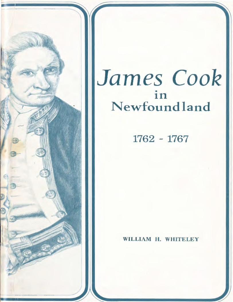
James Cook first came to Newfoundland in the summer of 1762, at the age of 34. The next six years of his life were to be given over to the survey of Newfoundland waters, a period during which he married and began to raise a family. Cook, then, spent some of his prime years in Newfoundland, before moving on to undertake his great voyages into the Pacific.
What sort of a person was Cook at this time? His qualities as a human being have been well described by his biographer, J.C. Beaglehole. Physically, he was a big man, over six feet, with the large-boned strong features typical of some Y orkshiremen. He had dark brown hair and brown eyes that were both quick and piercing. Strong and hardy, he had never had a serious illness, and possessed an iron constitution, a very necessary attribute for seamen in the eighteenth century. As one of his captains in the Pacific later remarked: "his stomach bore, without difficulty, the coarsest and most ungrateful food. Indeed temperance for him was scarcely a virtue; so great was the indifference with which he submitted to every kind ofself-denialn.l
When Cook came to Newfoundland, he had behind him 17 years of hard experience at sea, 9 in the little colliers that plied the North Sea coasts, and 8 in the Royal Navy, mostly in American waters. Cook had been the master of the "Pembroke H in the assault on Louisbourg in 17 58 and had helped to chart the St. Lawrence in 1759 preparatory to the British attack on the citadel of Quebec. The master of a ship, under the Captain, was responsible for her safe navigation and sea-keeping capabilities. As a result of his good work at Quebec, Cook was appointed master of the flagship of the North American squadron, the "Northumberland", and it was thus that he first came to Newfoundland, when the Commander-in-Chief, Lord Colville. led his squadron to the relief of St. John's, recently taken by the French.
Although Cook's formal education ended when he was only 14, he never ceased to learn from experience, and from the knowledge of others. The masters of ships were under standing Admiralty instructions to carry out surveys and make charts of the coasts they visited. Cook was one of the few ships' masters who took these directions seriously. The day after the fall of Louisb ourg, while strolling on the beach, Cook noticed a military surveyor, Samuel Holland, employing a plane table, and asked to be taught how to use it. This led to regular study sessions in surveying conducted under the benign yet demanding eye of Captain John Simcoe in the great cabin of the "Pembroke''. In addition~ Cook studied spherical trigonometry and practical astronomy, both necessary to the new kind of
3

scientific surveying techniques that were being developed. 2 Cook continued to study mathematics, geometry~ and astronomy in the "Northumberland", especially during the long winter nights in Halifax. His chart of the St. Lawrence was published in 1760, and before he came to Newfoundland Cook had carried out further surveys of the eastern coasts of Nova Scotia. Assiduous and self-possessed, always ready to do more than was officially required or expected, Cook by 1762 was a professional to his finger-tips, fully prepared for the surveying duties that lay before him.
As the "Northumberland'' moved from port to port in Newfoundland in the summer and fall of 1762, Cook's tireless surveying and chart-making attracted the attention not only of Lord Colville, but also of Captain Thomas Graves~ the then naval governor of Newfoundland. In August, Cook surveyed the old French capital of Placentia, and in September and October the harbours of Harbour Grace and Carbonear in Conception Bay, as well as of St. John's itself. At Carbonear he was joined by J.F.W. Des Barres, a military surveyor who was later to chart Nova Scotia and Cape Breton. Cook supplemented his charts with detailed sailing directions and copious remarks on suitable anchoring, watering and wooding places, in accordance with the general instructions laid down by the Admiralty. 3 In regard to Cook's surveys in Conception Bay, Lord Colville reported to the Admiralty Board that "hitherto we have had a very imperfect knowledge of these places, but Mr. Cook, who was particularly careful in sounding them, has discovered that ships of any size may lie in safety both in Harbour Grace and the Bay of Carbonear". 4
On the return of the "Northumberland n to England, Cook delivered his finished charts and observations to the Admiralty, was paid off in September, and proceeded to marry on 21 December, 1762, Miss Elizabeth Batts, the daughter of a London shopkeeper. The happy couple soon settled into their little cottage on Mile End Road near the Thames dockyards to the east of London, but the tranquility of their domestic life was not to remain uninterrupted for long.
In Lord Colville's judgment Cook was "well qualified for the work he has performed and for greater undertakings of the same kind".5 With the end of the Seven Years War in 1763 came Cook's real opportunity in Newfoundland. Under the peace terms, France, while stripped of her North American Empire, was allowed to retain fishing rights along the "Petit Nord" from Cape Bonavista on the east coast to Point Riche on the western shore, and was given St. Pierre and Miquelon as a shelter for her fishermen on the Grand Banks. As the governor of Newfoundland and as
4

(
the commodore of the Newfoundland squadron, Captain Graves was responsible for supervising the observance of the treaty terms by both English and French fishers. The need for reliable charts was keenly felt, both for safe navigation by shipping, and for enforcing the geographical terms of the international agreement. At the same time cartographical knowledge about the island was woefully lacking. Existing maps of the island were general in nature, with only main coastal features outlined. The south, west, and north coasts in particular remained known only in vague outline and were largely unexploited by English fishermen.
Faced with this situation, it is little wonder that Governor Graves decided to go beyond relying on what his captains might be expected to produce in the way of charts. The work of James Cook was favourably known to him as well as to the Admiralty, and it was only natural that Cook should be approached to conduct surveys in Newfoundland on a regular basis. With the support of the Board of Trade, Graves put forward Cook's name to the Admiralty Board, at the same time asking for permission to buy a small vessel in Newfoundland for the use of the surveyor. 6
The Admiralty subsequently appointed James Cook and an assistant to go to Newfoundland "in order to be employed in making surveys of the coasts and harbours of that Island, and for making drafts and charts thereof". 7 The actual coasts to be surveyed were left to the governor's discretion but the sequence of the surveys were largely determined by political factors. In 1763 the survey of St. Pierre and Miquelon, before their surrender to the French, was of first priority. The secretary of state for colonial affairs, Lord Egremont, was concerned about the possibility of illegal fishing and trade on the part of French based at the islands. A vigilant watch must be kept over them and Governor Graves had strict instructions to prevent contraband trade. To this end it was first obviously necessary that the islands and surrounding waters be carefully surveyed and charted. On his arrival in Newfoundland early in June, Graves at once despatched Cook to St. Pierre and Miquelon, on board the "Tweed", commanded by Captain Charles Douglas. In June and July Cook rapidly surveyed the islands, while the newly-appointed French governor was kept waiting aboard his ships, fuming at the delays, but partially mollified by the lavish hospitality laid on by Captain Douglas. 8
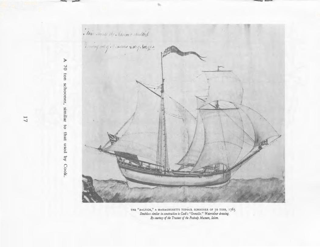
Foil owing the survey of St. Pierre and Miquelon, James Cook joined the survey ship which Governor Graves had purchased for him - the "Grenville,, a 68-ton schooner built in Massachusetts. He then proceeded north to survey Quirpon, Noddy and Croque harbours on the French
5
shore, and York harbour (Chateau Bay) on the Labrador coast. Quirpon and its nearby harbours were among the chief ports frequented by the French on the treaty shore. The governor was having difficulty in supervising the mixed fishery there, and accurate geographical knowledge was vital. In addition, one of the aims of the British government was to end trade between French fishers on the Petit Nord and Eskimoes of the Labrador coast. Quirpon, on the northern tip of Newfoundland, had long been known as a centre of this commerce. Chateau Bay had come to be recognized by British governors and merchants during the Seven Years War as a natural base for an English fishery on the Labrador coast. Consequently, Graves had been particularly instructed to encourage the fishery there, and to prevent French ships from either fishing on the coast or attempting to contact the natives. In the detailed remarks on his chart of Chateau, Cook enthusiastically concluded that "fishermen would certainly find their account in settling this place as cod and seals are here in great plenty". 9
Cook returned to England at the end of October, 1763, and spent the balance of the year producing finished charts from his surveys as well as from those taken by other ships in the squadron. The governor reported to the Admiralty that Cook, "whose pains and attention are beyond my description", was producing maps which would demonstrate "how extremely erroneous the present draughts are and how dangerous to ships that sail by them, and how generally beneficial to navigation the work now in hand will be when finished. Indeed, I have no doubt in a year or two more of seeing a perfect good chart of Newfoundland and an exact survey of most of the good harbours, in which there is not perhaps a part of the world that more abounds". 1 0
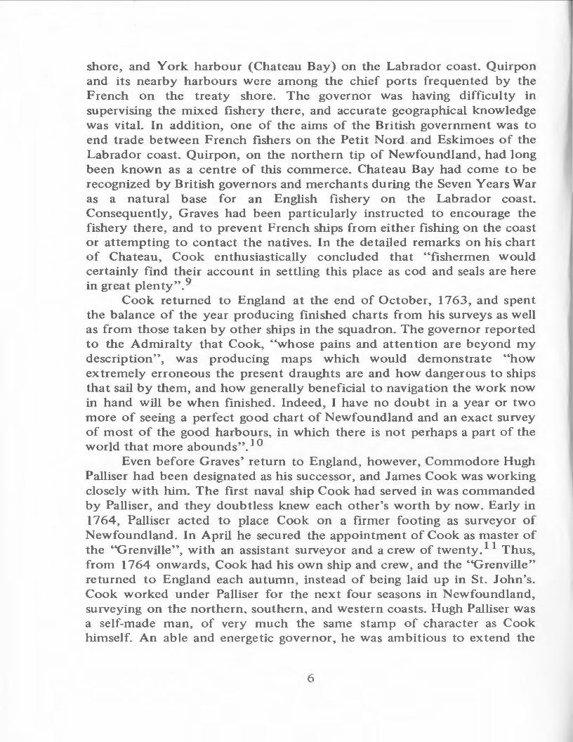
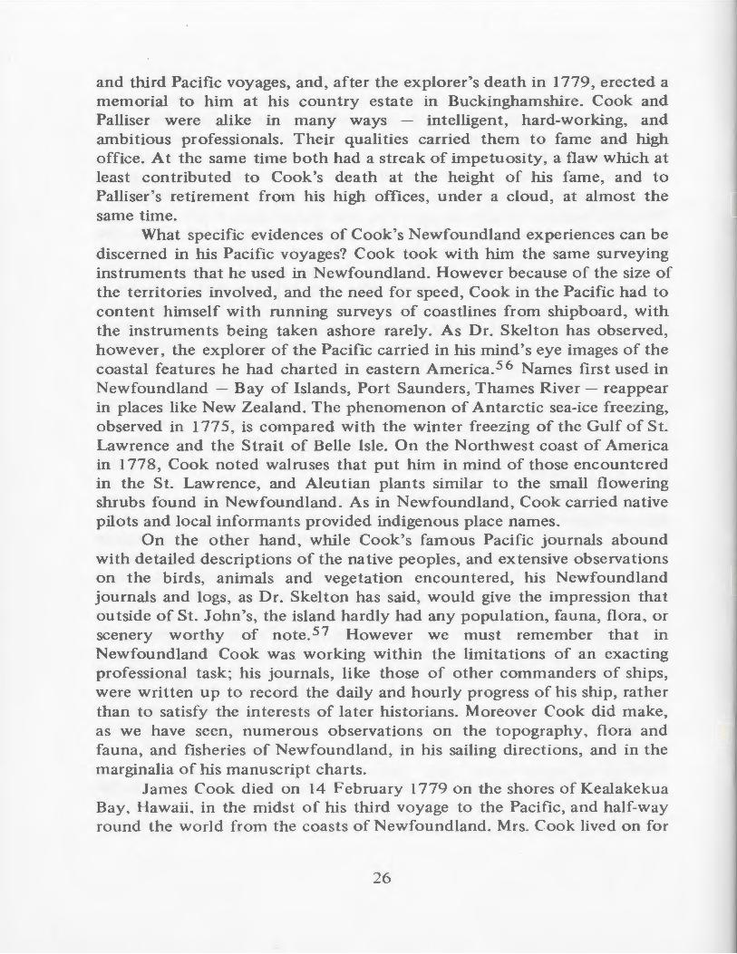
Even before Graves' return to England, however, Commodore Hugh Palliser had been designated as his successor, and James Cook was working closely with him. The first naval ship Cook had served in was commanded by Palliser, and they doubtless knew each other's worth by now. Early in 1764, Palliser acted to place Cook on a firmer footing as surveyor of Newfoundland. In April he secured the appointment of Cook as master of the "Grenville'', with an assistant surveyor and a crew of twenty. 11 Thus, from 1764 onwards, Cook had his own ship and crew, and the "Grenville'' returned to England each autumn, instead of being laid up in St. 1 ohn's. Cook worked under Palliser for the next four seasons in Newfoundland, surveying on the northern. southern, and western coasts. Hugh Palliser was a self-made man, of very much the same stamp of character as Cook himself. An able and energetic governor , he was ambitious to ex tend the
6

GULF OF
ST. LAURENCE
20 0 20
MILES
40
(1763)
60
NEWFOUNDLAND SURVEYS OF
7
JAMES COOK 1763-1767
~FRENCH SHORE
ATLANTIC OCEAN
range of the English ship fishers along the Newfoundland coasts~ and hoped to confine the French fishermen strictly within their treaty limits.
An incomplete copy has survived of Palliser's instructions to Cook for the south coast survey of 1765. After directing that an exact survey be made of the coasts, islands, and harbours, the Commodore ordered Cook to note in his remarks "everything that may be useful to the trade and navigation of His Majesty,s Subjects in those parts"', particularly "the beaches and places fit for stages and other conveniences for landing and drying fish as well as such as have been or may be used for that purpose''. 12 In addition, Cook was to describe carefully any sites suitable for the construction of forts to defend the harbours and their fisheries. Palliser called for, and received, a survey which went well beyond the merely geographical.
In the fishing season of 1763, difficulties had arisen between English and French fishermen on the northern treaty coast, where Cook had charted three harbours but not by any means the entire coast. In the spring of 1764 Palliser was given the most definite instructions to prevent any interruption of the French in the concurrent fishery on the treaty shore. 13 It was only natural, then, that the governor should first direct Cook to continue his survey of those largely uncharted but hotly contested northern waters, this time on a systematic basis, working along the coast from Griquet Bay, near Quirpon, westwards towards Point Riche. Cook started work in early July and got as far as Point Ferolle, just north of Point Riche, when he broke off the survey in early October to return to St. John's and England.
In the season of 1765, instead of continuing his survey southwest from Point Ferolle, as would seem most logical, James Cook sailed from England direct to Great St. Lawrence harbour on the Burin Peninsula, and spent the summer surveying the south coast from that harbour west to Bay Despair, including Fortune and Hermitage Bays. The change in survey venue was probably due to the fact that Palliser had uncovered evidence which indicated that the French were attempting to use St. Pierre and Miquelon as a military and naval base, as well as fishing in the inshore waters of the south coast, landing and cutting timber, and trading illegally with the inhabitants of Newfoundland. There was every reason for Palliser to want the bays and harbours adjacent to the French islands thoroughly charted, both to assist British warships in their patrols, and to encourage English fishern1en to venture along the heavily indented coastline. After completing a most detailed and complete map of the southeast coast in 1765, Cook pushed his survey on in 1766 from Bay Despair to beyond
8
Cape Ray. In 1767 he surveyed the Newfoundland west coast, a~riving at the close of the season at Point Ferolle, the terminus of his 1764 survey.
When James Cook left Newfoundland for the last time in the autumn of 1767, he had compiled a series of coastal charts unparalleled for nautical detail and fisheries information. All of his charts contain detailed soundings, with locations of rocks, reefs, and safe anchorages. They are large enough in scale to be of practical assistance to vessels navigating inshore waters. The observations that accompany each chart give sailing directions, with comments on tides, currents, winds, and compass variations. Appropriate notes are added on watering places, timber stands, and fishing places which would be useful to fishing adventurers.
The magnitude of Cook's accomplishment can only be fully appreciated when we remember the conditions under which he worked in the eighteenth century. Cook scientifically surveyed over 2000 miles of intricate coastline in essentially four summer seasons. In the age of wood, wind, and sail, everything had to be done by hand, from weighing anchor to taking deep-sea soundings. He had none of the modern advances such as echo-sounders and radar, which have done so much to speed up and lighten the surveying process. He had to survey an intricate coastline that was almost totally uncharted and but sparsely populated. If accident or sickness should strike, he could not radio for assistance, or quickly repair to some nearby town equipped with dockyard and medical facilities.
' In August of 1764 when Cook was away from the "Grenville'', surveying in the cutter near Cape Norman, a large powder horn exploded in his hand "which shattered it in a terrible manner". 14 The "Grenville" sailed east to Noddy Harbour where a French fishing ship lay which very fortunately happened to have a surgeon on board. However Cook bore the scar on his right hand until the day of his death. Scurvy was still one of the banes of seamen, although Cook was attentive to the diet of his men and his journals are liberally sprinkled with remarks about the brewing of "spruce beer" in various harbours, compounded from treacle and the tender green tips of the young spruce tree.
In the era before steam, Cook relied upon the ocean currents, sail power and rowing to carry him and his crew in their little schooner round the coasts of Newfoundland. The weather in Newfoundland is not always predictable, even in the summertime" For days on end Cook might be immobilized, particularly on the south coast, by "much rain and thick fogg", or "strong gales and hard rain". Added to this were the dangers posed by the hidden rocks and shoals which studded the rugged coastline.
9
In October of 1764 the ship's small boat struck a reef off Point Ferolle and filled with water, but the crew was saved by the cutter. 15 In July, 1765, when entering Long Harbour, Fortune Bay, the "Grenville'' ran upon a rock. All the ballast and casks of provisions had to be taken out of the ship until "at midnight the water flowing got her off'~. 16 At the end of that season, Cook careened the "Grenville" in Ship Cove, Bay Despair, so that his carpenter might repair the damaged fore foot, while the ship's bottom was cleaned and others of the crew were busy wooding, watering, brewing, and setting the rigging. In sum, Cook in his Newfoundland survey was very much on his own.
A little realized circumstance that must have added to Cook's burdens was the high rate of turnover in crew. Although the complement of the "Grenville" was but 20, a total of 77 seamen served on board in the four seasons from 1764 to 1767.17 Although some men left through transfer to other ships, the desertion rate was high. On his last voyage to Newfoundland in April, 1767, for example, Cook sailed with an almost completely new crew, only three of whom had served under him before. Most of the crew signed on the "Grenville" at her home port of Deptford, and left the ship, clandestinely or otherwise, at the end of one season. A few seamen signed on in St. John's and one at Great St. Lawrence, but none of the crew appear to have been native Newfoundlanders.
Cook strove to minimize the risks of the survey as best he could. At the end of his first full scale season, he got the schooner rigged into a brig,
for schooners are the worst of vessels to go upon any discovery, for in meeting with any unexpected danger their staying cannot be depended upon, and for want of sail to lay a back they run themselves ashore before they wear, this I experienced in the "Grenville" schooner last summer in the Straits of Belle Isle, when I see the condition her bottom is in it supprizeth me that she ever came off.18
In the voyage of 1765, Cook, doubtless remembering his own painful experience the preceding year, brought out a box of medicines at his own expense. In April of 1768, although on the verge of leaving the Newfoundland survey for the Pacific, Cook persuaded the Admiralty to put a surgeon's mate into the "Grenville'', pointing out that the vessel "is employed during the whole summer at places distant from any of His Majesty's ships and that from the nature of the service her crew are liable to many accidents besides such disorders as are common to seamen". 19
Cook was also in the habit of employing local pilots to point out the "rocks and hidden dangers", especially on the south and west coasts. In
10
the 1765 season, for example, four pilots were engaged at 4 shillings a day each, John Beck for the coast west of Great St. Lawrence, Morgan Snook for Fortune Bay, John Dawson for Connaigre and Hermitage Bays, and John Peck for the '13ay of Despair". 20
Cook's charts are remarkable for the accuracy of their nautical detail because he conducted not merely a "running survey" of the coasts, but, wherever possible, a "trigonometrical'' survey based on distances ascertained by triangulation from carefully chosen shore positions. 21 The triangulation scheme would then be positioned on the surface of the earth by astronomical observations which provided the geographical co-ordinates and the direction of the true north. This was the type of scientific survey which Cook had learned from military surveyors like Samuel Holland and which enabled him to carry out the most thorough large-scale hydrographic survey ever attempted overseas, providing the first charts which mariners did not need to cast aside as they drew near to land, but on which they could rely with confidence to reach port safely.
Cook took care to provide himself with the finest and most advanced instruments of the day which made this kind of survey possible. When he went out on his first full season's work in 1764, he carried with him many "extra stores wanting for the surveying service", including "Dr. Knight's azimuth compass", deep sea and hand leads, hatchets and pick axes, large red, white, blue, and yellow flags for station markers, and inch deals for constructing drawing tables in the "Grenville". 22
' When Cook began his survey of the northern coast in July of 1764, then, at Sacred Bay, he first went on shore and "Measured a Base Line and fixed Flaggs on the different Islands, etc. " 2 3 From the measured base, the distances to other points could be f'lX.ed by triangulation with a theodolite, and a geometrical network built up covering the area of the coast being surveyed. On some of Cook's manuscript maps, such as that of Old Ferolle Harbour, the dotted lines of his triangulations still remain, indicating the method of his work. 24 Cook's survey of the north coast was geographically oriented when he f'Ixed the latitude of Cape Norman by meridional observation on 2 August. Determination of longitude, however, was a more difficult matter at this time and Cook's Newfoundland charts are graduated only in latitude.
We can thus reconstruct reasonably confidently how Cook went about his work on the coasts of Newfoundland. When he sailed in to survey a completely uncharted locality, as most of them were, his first step would be to find secure anchorage by use of the ship's boats. The old adage that "no surveying day is too long" was doubtless well observed by
1 I

Cook. Provided the day was fine, the ship's cutter and small boat would probably leave the "'Grenville" around seven in the morning for inshore work. They would rejoin the ship about six in the evening, unless engaged in an overnight expedition. In a new harbour, after getting ashore, Cook would first select a suitable level site for his base line. His men would then be employed rowing about to various promontories and climbing hills in order to set up station· flags for the points to be measured off by the theodolite. Once plotted on a large sheet, the fixed points would then be transferred to field boards which were used for sounding, coast lining, and topography. 25 Other sailors would be recording the rise and fall of the tides, in order to reduce the soundings to the level of mean low water.
While the boats worked in the shallower water, the "Grenville" would be taking deep-sea soundings further off the coast. If Cook was in a large harbour for any length of time, parties would be sent ashore for wood, water, and to erect a tent for the brewing of spruce beer. The "Grenville" herself might be hauled ashore to have her bottom scrubbed, her rigging overhauled, and her sails repaired and set out to dry. Cook himself would interview the local people, if any, in order to gather place names, and would keep an eye out for likely fishing places. After spending four or five days in a harbour and its environs, Cook would then sail for the next harbour, sounding and sketching in the coastline as he went. The latitude of headlands such as Cape Norman and Cape Anguille would be taken by a quadrant, with the variation determined by the azimuth compass. Sometimes, when a deep bay or river was to be investigated, Cook might be away from the "Grenville" with a boat's crew for as much as a week or ten days. In 1766 he asked the Admiralty for a tent "to serve as a covering to them in the night and in bad weather''. 26
In much this fashion, then, Cook made his way round the coasts of Newfoundland for four consecutive summers. In the summer of 1764 he met near Quirpon Jens Haven, the pioneer Moravian missionary to the Eskimoes, who was seeking a passage to Labrador. In July of 1765, when anchored in a bay near _Great Garnish on the Burin peninsula, he took on board two men lost in the woods for almost a month and "almost perishing for want of subsistence". In May of 1767 he met a tribe of Micmac Indians in St. George's Bay on the west coast. From time to time he encountered French fishing ships in harbours on the French shore, or English fishing ships in well known ports like Grand Bank and Harbour Breton on the south coast. Occasionally he would exchange news with a royal frigate or sloop cruising on station duty. Generally, however, it was a lonely and painstaking duty, sailing along mile after mile of deserted coast,
12
probing into uninhabited bays and inlets, carefully sounding waters never before charted. Only a commander of great patience and perseverance could have carried out the task as thoroughly as Cook did. ·
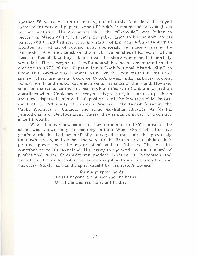
At the end of each surveying season, the "Grenville" would make her way back to St. John's and thence across the Atlantic to her home base at Deptford Yard, on the Thames near London. There James Cook would compile his "fair charts", embracing all the data gathered in the field, for submission to the Admiralty. The finished manuscript' charts were generally on a scale of one inch to a mile, with insets of harbours on a scale of three inches to a mile. Soundings were .liberally given, "leading lines" were drawn into harbours, and separate symbols denoted rocks above and below water. On the borders of the manuscript charts were copious remarks -on navigation and the fishery. Topographical detail was added, with considerable brushwork in delicate shades of brown and green indicating relief and land-cover.
Cook's life in the years between 1763 and 1768 followed a regular pattern. In April of each year, after mustering his crew, and getting his newly refurbished surveying instruments aboard, he would sail down the Thames, stopping at the arsenal at Woolwich to pick up a supply of guns and powder. By the latter part of May or early June he would have arrived on the section of coast to be surveyed that year and commence the work that was to occupy the summer months. October would see him back in St. John's where he would usually have a word with Palliser before sailing for England.
Sometime between the latter part of November and the middle of December, the ''Grenville" would once again be at her moorings in Deptford Yard. Cook would be able to spend Christmas with his ever growing family at Mile End Road across the Thames from Deptford, perhaps seeing for the first time a son or daughter born while he was away. The winters, however, were a busy time for Cook. He had to compile his finished charts and write up the accompanying sailing directions, working either at home or over at Deptford. Trips had to be made to the Admiralty offices in London to report orally on his work, turn in his maps and sailing directions, and consult with Palliser on the work of the next season. The ship's crew had to be brought up to strength once again, the "Grenville" refitted and reprovisioned, and his precious scientific instruments sent to London for repair and readjustment.
Through his Newfoundland charts, James Cook provided a tremendous amount of information about the coastal waters, topography, and fisheries of the island. Since he often spent several days working in
13
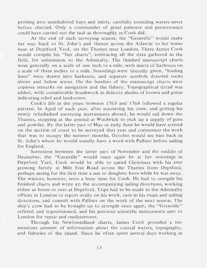
one harbour, his sailing directions are detailed and exact. For example, he carefully. describes the dangers to navigation to be found in the poor harbours on the Newfoundland...tside of the Strait of Belle Isle. Flowers Cove, said he, is fit only for boats or small vessels, and the numerous rocks and ledges inside and outside the harbour are pinpointed. For the first time mariners now had precise directions for reaching good anchorages in hitherto little used but commodious harbours. Ships sailing into Great St. Lawrence Harbour, for example,
must not approach too near the Cape, for fear of being becalmed under the high land. Great ships must anchor between Blue Beach Point (which is the first low point on the west side) and the beach on the same side near the head of the harbour, they will lay tolerable well sheltered from the sea winds, the bottom none of the best, and the water from 14 to 6 fathoms deep. Small vessels lay at the head of the harbour above the beach, secure from all winds. 2 8
Similarly in his chart of the southwest coast Cook lays down detailed directions for entering Port-aux-Basques, with special emphasis on giving the Frying Pan Rocks a wide berth. 2 9
Captain Henry Bayfield, surveying the Gulf of St. Lawrence over 60 years later, verified the accuracy of Cook's chartwork, while freely castigating the work of Des Barres and others. In August of 1833, in the course of investigating the western coast of Newfoundland, he stood in close to the Port au Port peninsula and Hfound Cook's chart as usual extremely correct''. 3 0 Bayfield also testified to the accuracy of Cook's astronomical observations: "I have always found Cook's latitudes correct within a mile of the truth wherever I have observed''. 3 1
In addition to their nautical detail, Cook's charts are remarkable for the amount of topographical information conveyed, as well as for remarks on vegetation and animal life. Timber stands and watering places receive special attention because of their importance to the fishery. Pistolet Bay in northern Newfoundland, for example, he notes as being everywhere clothed with wood which was resorted to by fishermen from barren Quirpon. hi the observations which fill the margins around his magnificent manuscript chart of the south coast from Great St. Lawrence to Bay Despair, Cook describes each bay in turn carefully and minutely, with its various islands, coves, and harbours. Of Fortune Bay in general, the surveyor remarks that the northern coast is dominated by craggy barren hills, with many ponds, rivers, and woods at the heads of the bays. The interior country, largely clear of woods, and with but scanty soil, abounds
14
Ot'
TnJ-: H.\.Rnorll o•·
TRt:l'ASSEY
with
!\H'TTO X :uuliU Sl'.'\. V
UA~·s .
1'1. ·'<.'.1-~~TI.,.
~· · • .fd NU'J' ( •• , •JC· .
/ :O:a·ttlt• ut•!\tilt·•··
L..! . -~ -· ·- :.._._ .
.. ·' l"ORTl"G-\.L .J ,.. T
ro,·t:
HARUOl'R.
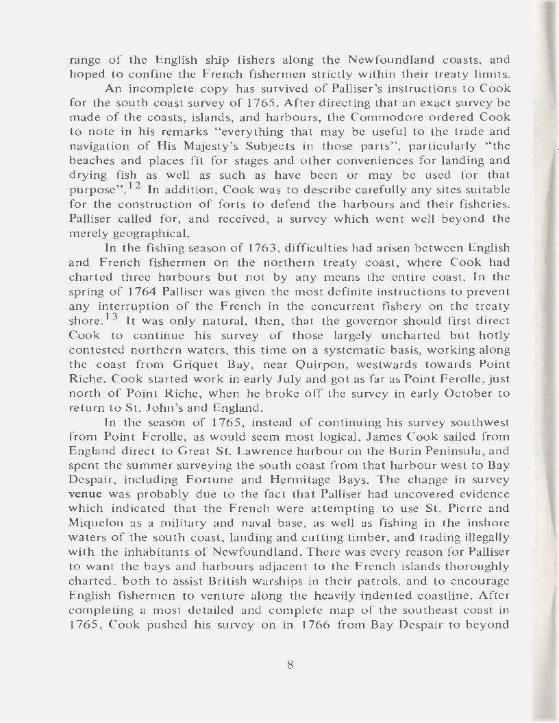
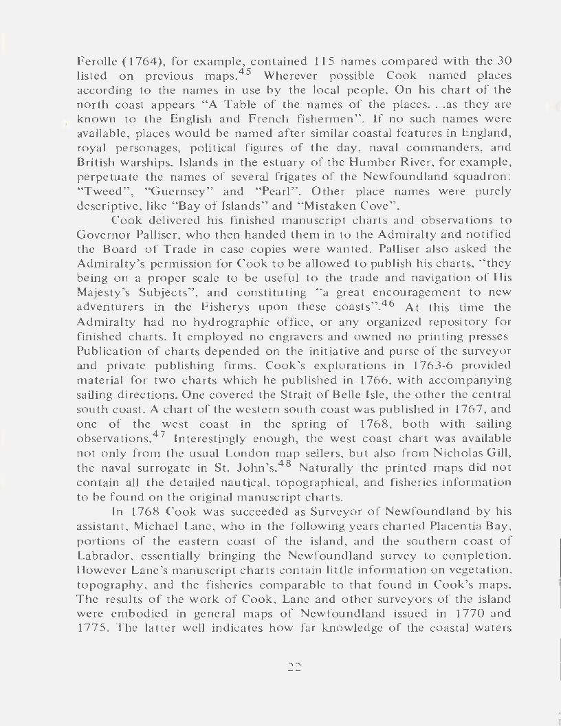
Harbour Charts: Trepassey, Placentia, St. Mary's.
15

S~ JOHNS IIARBO"l'R .
TRINITY
IIARBOUR .
:C-AXH om:ER.~ mul.
.fuB:Bm:m. G-RACE
SC"ol~ o£ ml.f' -:\tilt.~.
THE IIARBOUR S OF
FERRYT.A..."'D.A.VD .AQl.'J\FOR.T -...-iJh.
C~LIN B-~Y.
•2-···
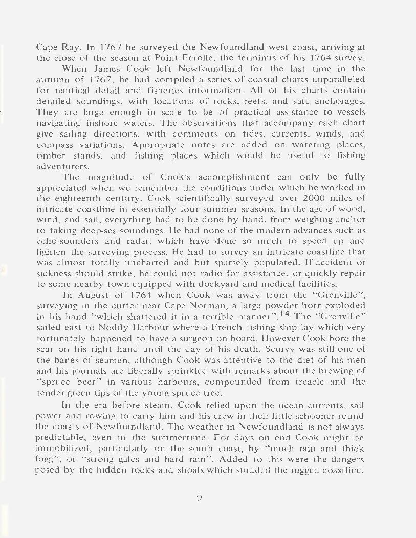
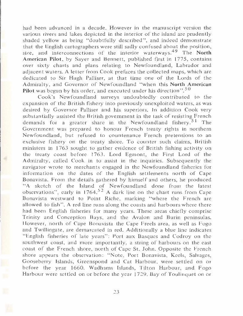
Harbour Charts: Trinity, Carbonear and Harbour Grace, St. John's, Ferryland.
16
> -...J 0 ....... 0 ::I Ill (") ;::t 0 0 ::I (";; ~~
Ill ..... 3 .....
......... ......
....J ~ .-+ 0 .-+ ;::t ~ .......
c Ill (";;
0..
0" '< (j 0 0 ~
f .r:
/ I
" .. ,,
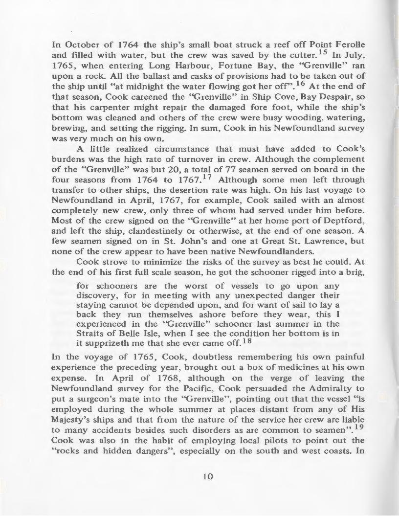
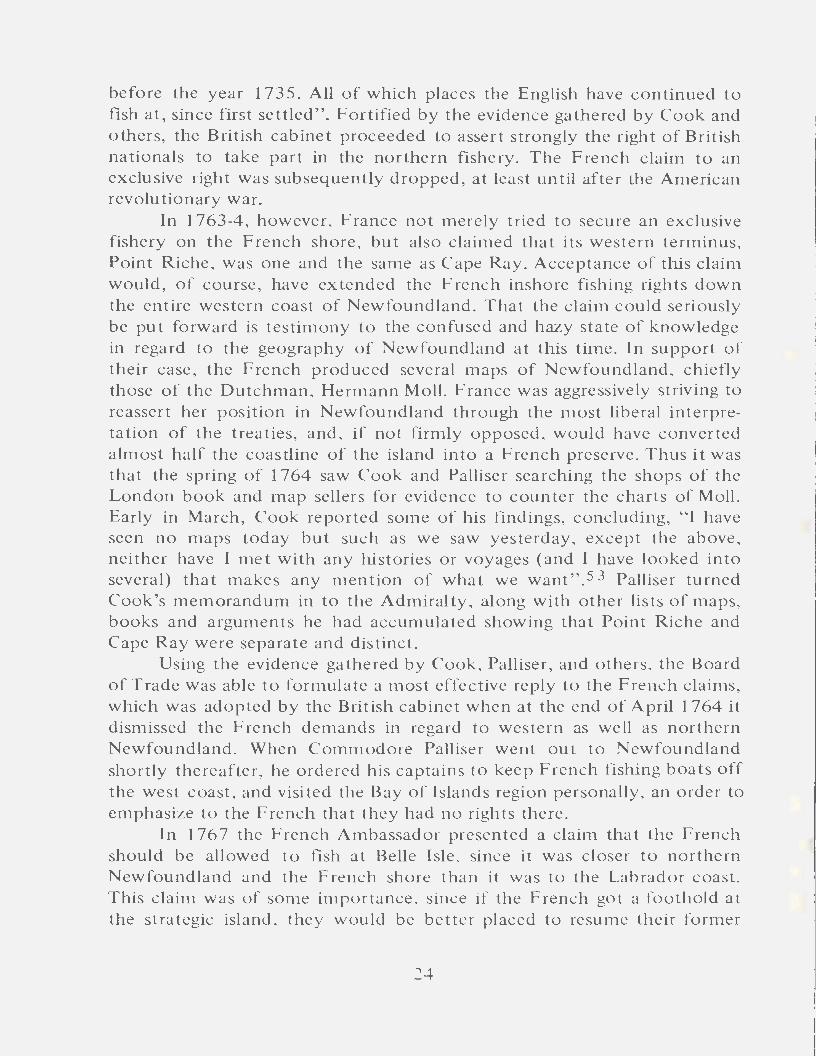
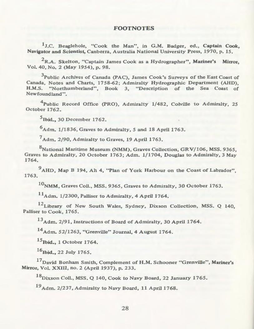
THE "BALTICK," A MASSACHUSETTS TOPS.A IL SCHOONER OF 70 TONS, 1765 Doubtless similar in construction to Cook's "Grenville." Watercolour drawing,
B_y courtesy of the Trustees of the Peabody Museum, Salem.
\,
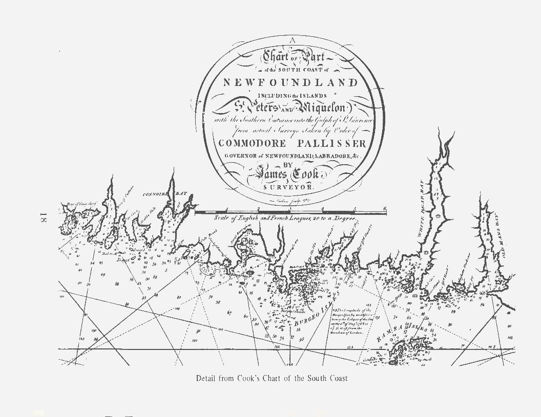
Detail from Cook's Chart of the South Coast
with large deer, bears, and foxes, while in the ponds and rivers are to be found beaver, otter, salmon, trout, wild geese, ducks, and so on. At the head of Bay Despair, Cook found "many thousands of acres of land well clothed with all sorts of wood peculiar to this country, such as pine, fir, birch, witchhazle, and kinds of spruce, etc."32
Cook describes dispassionately the rocky and precipitous cliffs of the Newfoundland southwest coast, merely remarking that the land on the shore and for about four or five leagues inland "is almost everywhere of an uneven craggy barren surface distinguished by hills and vallies, of great variety of height, depth, and extent. The vallies are for the most part watered with ponds and small brooks, with which the whole country very much abounds".33
Andrew Kippis, who wrote a biography of James Cook when many of his contemporaries were still living, states, on the basis of information from Sir Hugh Palliser, that Cook penetrated farther into the interior of Newfoundland than any previous explorer, and discovered several large lakes. 34 However this may be, there is no doubt that Cook scaled some of the higher coastal hills, and was able to report on portions of the interior near the coast. In describing Cape Norman, for example, Cook comments that the land is of barren soil "for many miles into the country''. 35 In 1766 the surveyor observes that a little way inland from the head of White Bear Bay, one of the deepest indentations in the southwest coast, one has "a very extensive prospect of the interior parts of the country, which appears to be a barren rock of a pretty even surface covered with white moss and watered by a great number of ponds". 36
The only real penetration of Cook into the interior of Newfoundland would seem to have occurred in September of 1767 when he led a five day boat expedition up the Humber River from the Bay of Islands. He went four miles up Deer Lake "but could see no land at theN. E. end, the weather being then very clear". 3 7 However he learned from winter residents that the lake was about 25 miles long. He notes that the banks of the river and lake are well stocked with timber and comments: "In this river has formerly been a very great salmon fishery and the Bay of Islands has been much frequented by fishers". 38 Once again Cook was supplementing his own observations with information gathered from natives of the country.
Finally, Cook's charts and observations contain an amazing amount of detailed information on present and possible future fisheries, collected for the guidance of the governor, the home authorities, and the "fishing adventurers". Thus his 1764 charts of the northern coast are dotted with
19
coioured symbols denoting "stages with beach for drying fish on" (in red), "stages with flakes for drying fish on'' (in black), and "places where stages may be built" (in yellow). Places for at least twenty-eight new fishing establishments are indicated. Naturally many of the old and proposed fishing places are marked in harbours already well-known. In historic Quirpon, where Cook well describes the shore rising in barren hills directly from the water, he says "there are, or might be made, twenty convenient ship's rooms, and above that number of ships have been known fishing there in one summer". 39 However the surveyor also identifies suitable places for fishing establishments in new harbours further west, including Cook's Harbour in well-wooded Pistolet Bay, and the Bay St. Genevieve on the Strait of Belle Isle. He makes the point that the latter bay has never been frequented by fishermen, although it seems to be well situated for the cod fishery, and has ample wooding and watering facilities. Stages could be built on the inside of Gooseberry Island and on the north point of the entrance to the Southwest Arm. No detail is too small to escape his notice. At Cape Onion he observes there is a small cove "where it's thought a small vessel might fish to advantage".
James Cook investigated particularly thoroughly the present and possible future fisheries on the south coast adjacent to St. Pierre and Miquelon. His massive chart of that coast is ·drawn on a scale of an inch to the mile, with insets of eight major harbours, on a scale of three inches to the mile. 4 ° Cook depicts in the various harbours stages for the splitting of fish, marked in red, and convenient places for the building of stages for the landing and drying of fish, marked in yellow. Forty stages in current use are identified, scattered among eleven harbours. In addition there are some twenty places marked as suitable for new stages, in these same harbours, which include Great St. Lawrence on the Burin Peninsula, Harbour Breton in Fortune Bay, and Hermitage Cove, to the westward. Moreover, forty-seven places for new fishing establishments are marked in twentyseven new harbours as yet unexploited, among them Great Jervis in Bay Despair, Gaultois and Picarre in Hermitage Bay, and Great Garnish and similar coves along the east coast of For tune Bay.
In his detailed observations on the margins of the chart, Cook notes that Harbour Breton is the best place for carrying on a fishery on the north side of Fortune Bay, and the only one at present frequented by shipping. The West Country firm of Clark and Young, of Poole, had recently constructed some good buildings there, and many convenient places were available for building stages and drying fish. Although French fishers had used Bande de L'Arier (Belloram), east of Harbour Breton,
20
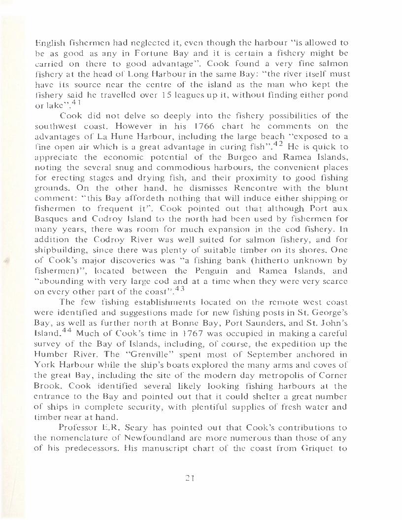
English fishermen had neglected it, even though the harbour His allowed to be as good as any in For tune Bay and it is certain a fishery might be carried on there to good advantage". Cook found a very fine salmon fishery at the head of Long Harbour in the same Bay: "the river itself must have its source near the centre of the island as the man who kept the fishery said he travelled over 15 leagues up it, without finding either pond or lake" .4 1
Cook did not delve so deeply into the fishery possibilities of the southwest coast. However in his 1 7 66 chart he comments on the advantages of La Hune Harbour, including the large beach "exposed to a fine open air which is a great advantage in curing fish''. 42 He is quick to appreciate the economic potential of the Burgeo and Ramea Islands, noting the several snug and commodious harbours, the convenient places for erecting stages and drying fish, and their proximity to good fishing grounds. On the other hand, he dismisses Rencontre with the blunt comment: "this Bay affordeth nothing that will induce either shipping or fishermen to frequent it". Cook pointed out that although Port aux Basques and Codroy Island to the north had been used by fishermen for many years, there was room for much expansion in the cod fishery. In addition the Codroy River was well suited for salmon fishery, and for shipbuilding, since there was plenty of suitable timber on its shores. One of Cook's major discoveries was "a fishing bank (hitherto unknown by fishermen)", located between the Penguin and Ramea Islands, and "abounding with very large cod and at a time when they were very scarce on every other part of the coast".43
The few fishing establishments located on the remote west coast were identified and suggestions made for new fishing posts in St. George's Bay, as well as further north at Bonne Bay, Port Saunders, and St. John's Island.44 Much of Cook's time in 1767 was occupied in making a careful survey of the Bay of Islands, including, of course, the expedition up the Humber River. The ''Grenville" spent most of September anchored in York Harbour while the ship's boats explored the many arms and coves of the great Bay, including the site of the modern day metropolis of Corner Brook. Cook identified several likely looking fishing harbours at the entrance to the Bay and pointed out that it could shelter a great number of ships in complete security, with plentiful supplies of fresh water and timber near at hand.
Professor E.R. Seary has pointed out that Cook's contributions to the nomenclature of Newfoundland are more numerous than those of any of his predecessors. His manuscript chart of the coast from Griquet to
21
Ferolle (1764), for example, contained 115 names compared with the 30 listed on previous maps.45 Wherever possible Cook named places according to the names in use by the local people. On his chart of the north coast appears "A Table of the names of the places ... as they are known to the English and French fishermen". If no such names were available, places would be named after similar coastal features in England, royal personages, political figures of the day, naval commanders, and British warships. Islands in the estuary of the Humber River, for example, perpetuate the names of several frigates of the Newfoundland squadron: "Tweed", "Guernsey" and "Pearl,_ Other place names were purely descriptive, like "Bay of Islands" and "Mistaken Cove,'.
Cook delivered his tmished manuscript charts and observations to Governor Palliser, who then handed them in to the Admiralty and notified the Board of Trade in case copies were wanted. Palliser also asked the Admiralty's permission for Cook to be allowed to publish his charts, "they being on a proper scale to be useful to the trade and navigation of His Majesty's Subjects", and constituting "a great encouragement to new adventurers in the Fisherys upon these coasts".46 At this time the Admiralty had no hydrographic office, or any organized repository for finished charts. It employed no engravers and owned no printing presses" Publication of charts depended on the initiative and purse of the surveyor and private publishing firms. Cook's explorations in 1763-6 provided material for two charts which he published in 1766, with accompanying sailing directions. One covered the Strait of Belle Isle, the other the central south coast. A chart of the western south coast was published in 1767, and one of the west coast in the spring of 1768, both with sailing observations.47 Interestingly enough, the west coast chart was available not only from the usual London map sellers, but also from Nicholas Gill, the naval surrogate in St. John's.48 Naturally the printed maps did not contain all the detailed nautical, topographical, and fisheries information to be found on the original manuscript charts.
In 1768 Cook was succeeded as Surveyor of Newfoundland by his assistant, Michael Lane, who in the following years charted Placentia Bay, portions of the eastern coast of the island, and the southern coast of Labrador, essentially bringing the Newfoundland survey to completion. However Lane's n1anuscript charts contain little information on vegetation, topography, and the fisheries comparable to that found in Cook's maps. The results of the work of Cook, Lane and other surveyors of the island were embodied in general maps of Newfoundland issued in 1770 and 1775. The latter well indicates how far knowledge of the coastal waters
had been advanced in a decade. However in the manuscript version the various rivers and lakes depicted in the interior of the island are prudently shaded yellow as being "doubtfully described", and indeed demonstrate that the English cartographers were still sadly confused about the position, size, and interconnections of the interior waterways. 49 The North American Pilot, by Sayer and Bennett, published first in 1775, contains over sixty charts and plans relating to Newfoundland, Labrador and adjacent waters. A letter from Cook prefaces the collected maps, which are dedicated to Sir Hugh Palliser, at that time one of the Lords of the Admiralty, and Governor of Newfoundland "when this North American Pilot was begun by his order, and executed under his direction". 5°
Cook's Newfoundland surveys undoubtedly contributed to the expansion of the British fishery into previously unexploited waters, as was desired by Governor Palliser and his superiors. In addition Cook very substantially assisted the British government in the task of resisting French demands for a greater share in the Newfoundland fishery. 51 The Government was prepared to honour French treaty rights in northern Newfoundland, but refused to countenance French pretensions to an exclusive fishery on the treaty shore. To counter such claims, British ministers in 1763 sought to gather evidence of British fishing activity on the treaty coast before 1763. Lord Egmont, the First Lord of the Admiralty, called Cook in to assist in the inquiries. Subsequently the navigator wrote to merchants engaged in the Newfoundland fisheries for information on the dates of the English settlements north of Cape Bona vista. From the details gathered by himself and others, he produced "A sketch of the Island of Newfoundland done from the latest observations,, early in 1764.5 2 A dark line on the chart runs from Cape Bonavista westward to Point Riche, marking "where the French are allowed to fish". A red line runs along the coasts and harbours where there had been English fisheries for many years. These areas chiefly comprise Trinity and Conception Bays, and the Avalon and Burin peninsulas. However, north of Cape Bonavista the Cape Freels area, as well as Fogo and Twillingate, are demarcated in red. Additionally a blue line indicates "English fisheries of late years": Port aux Basques and Codroy on the southwest coast, and more importantly, a string of harbours on the east coast of the French shore, north of Cape St. John. Opposite the French shore appears the observation: "Note, Port Bona vista, Keels, Salvages, Gooseberry Islands, Greenspond and Cat Harbour, were settled on or before the year 1660. Wadhams Islands, Tilton Harbour, and Fogo Harbour were settled on or before the year 1729. Bay of Toulinquet on or
23
before the year 1735. All of which places the English have continued to fish at, since first settledH. Fortified by the evidence gathered by Cook and others, the British cabinet proceeded to assert strongly the right of British nationals to take part in the northern fishery. The French claim to an exclusive right was subsequently dropped, at least until after the American revolutionary war.
In 1763-4, however, France not merely tried to secure an exclusive fishery on the French shore, but also claimed that its western terminus, Point Riche, was one and the same as Cape Ray. Acceptance of this claim would, of course, have extended the French inshore fishing rights down the entire western coast of Newfoundland. That the claim could seriously be put forward is testimony to the confused and hazy state of knowledge in regard to the geography of Newfoundland at this time. In support of their case, the French produced several maps of Newfoundland, chiefly those of the Dutchman, Hermann Moll. France was aggressively striving to reassert her position in Newfoundland through the most liberal interpretation of the treaties, and, if not firmly opposed, would have converted almost half the coastline of the island into a French preserve. Thus it was that the spring of 1764 saw Cook and Palliser searching the shops of the London book and map sellers for evidence to counter the charts of Moll. Early in March, Cook reported some of his findings, concluding, "I have seen no maps today but such as we saw yesterday, except the above, neither have I met with any histories or voyages (and I have looked into several) that makes any mention of what we want".s 3 Palliser turned Cook's memorandum in to the Admiralty, along with other lists of maps, books and arguments he had accumulated showing that Point Riche and Cape Ray were separate and distinct.
Using the evidence gathered by Cook, Palliser, and others, the Board of Trade was able to formulate a most effective reply to the French claims, which was adopted by the British cabinet when at the end of April 1764 it dismissed the French demands in regard to western as well as northern Newfoundland. When Commodore Palliser went out to Newfoundland shortly thereafter, he ordered his captains to keep French fishing boats off the west coast, and visited the Bay of Islands region personally, an order to emphasize to the French that they had no rights there.
In 1767 the French Ambassador presented a claim that the French should be allowed to fish at Belle Isle, since it was closer to northern Newfoundland and the French shore than it was to the Labrador coast. This claim was of some importance, since if the French got a foothold at the strategic island, they would be better placed to resume their former
24

trade ~with the natives of the Labrador coast. Palliser, in conference with the Ambassador, was able to counter the French case by demonstrating authoritatively that Belle Isle was wholly nearer Labrador than Newfoundland. As he reported to Lord Shelburne: ''This is established beyond a doubt by an actual survey taken of those parts by the King's surveyor before this claim was set up, and a chart constructed on those surveys having been published, I referred him to it, and so this subject ended". 54
In the spring of 1768 James Cook was seconded from the Newfoundland survey to take command of what was to be the first of his great expeditions to the South Seas. It may appear strange that the commander of a small survey vessel, who only held the rank of Master in the navy, should have been given such responsibility. The appointment, however, indicates that he was known to those in authority as being more than a competent nautical surveyor. In his Newfoundland period, Cook demonstrated not only his proficiency as a surveyor, but also his prowess as a mathematician and astronomer. While surveying the south coast in 1766, Cook observed an eclipse of the sun from one of the Burgeo Islands near Cape Ray. The results of his observations were communicated to the Royal Society through the good offices of Dr. John Bevis, a member of the Society, who praised Cook as "a good mathematician and very expert in his business". 55
Even more important, Cook was now known as a leader of judgment and intelligence who could be counted upon to carry out the missions assigned to him. As we have seen, his Newfoundland charts were replete not only with nautical detail, but also with observations and judgments designed to give the Governor and the British government the fullest information about present fishing places and future possibilities. Palliser and the Admiralty Board knew the value of his work and realized how it fitted him for even broader responsibilities in the Pacific. Moreover Cook had worked closely with Governors Graves and Palliser on geographical problems arising from Anglo-French competition in the Newfoundland fishery. They were aware of how his labours had forwarded the aims of British policy in Newfoundland. At various times, Cook had reported on his work directly to officials at the cabinet level, particularly in 1763-4, when Lord Egmont consulted him about the situation on the French shore.
Hugh Palliser himself left the Governorship of Newfoundland in the spring of 1769, to become Comptroller of the navy and eventually one of the Lords of the Admiralty. He assisted in the outfitting of Cook's second
25
and third Pacific voyages, and, after the explorer's death in 1779, erected a memorial to him at his country estate in Buckinghamshire. Cook and Palliser were alike in many ways - intelligent, hard-working, and ambitious professionals. Their qualities carried them to fame and high office. At the same time both had a streak of impetuosity, a flaw which at least contributed to Cook's death at the height of his fame, and to Palliser's retirement from his high offices, under a cloud, at almost the same time.
What specific evidences of Cook's Newfoundland experiences can be discerned in his Pacific voyages? Cook took with him the same surveying instruments that he used in Newfoundland. However because of the size of the territories involved, and the need for speed, Cook in the Pacific had to content himself with running surveys of coastlines from shipboard, with the instruments being taken ashore rarely. As Dr. Skelton has observed, however, the explorer of the Pacific carried in his mind's eye images of the coastal features he had charted in eastern America. 5 6 Names first used in Newfoundland - Bay of Islands, Port Saunders, Thames River- reappear in places like New Zealand. The phenomenon of Antarctic sea-ice freezing, observed in 1775, is compared with the winter freezing of the Gulf of St. Lawrence and the Strait of Belle Isle. On the Northwest coast of America in 1778, Cook noted walruses that put him in mind of those encountered in the St. Lawrence, and Aleutian plants similar to the small flowering shrubs found in Newfoundland. As in Newfoundland, Cook carried native pilots and local informants provided indigenous place names.
On the other hand, while Cook's famous Pacific journals abound with detailed descriptions of the native peoples, and extensive observations on the birds, animals and vegetation encountered, his Newfoundland journals and logs, as Dr. Skelton has said, would give the impression that outside of St. John's, the island hardly had any population, fauna, flora, or scenery worthy of note. 57 However we must remember that in Newfoundland Cook was working within the limitations of an exacting professional task; his journals, like those of other commanders of ships, were written up to record the daily and hourly progress of his ship, rather than to satisfy the interests of later historians. Moreover Cook did make, as we have seen, numerous observations on the topography. flora and fauna, and fisheries of Newfoundland, in his sailing directions, and in the marginalia of his manuscript charts.
James Cook died on 14 February 1779 on the shores of Kealakekua Bay, Hawaii, in the midst of his third voyage to the Pacific, and half-way round the world from the coasts of Newfoundland. Mrs. Cook lived on for
26
another 56 years, but unfortunately, out of a mistaken piety, destroyed many of his personal papers. None of Cook's four sons and two daughters reached maturity. His old survey ship, the "Grenville", was "taken to pieces'' in March of 1775. Besides the pillar raised to his memory by his patron and friend Palliser, there is a statue of him near Admiralty Arch in London, as well as, of course, many memorials and place names in the Antipodes. A white obelisk on the black lava benches of Kaawaloa, at the head of Kealakekua Bay, stands near the shore where he fell mortally wounded. The surveyor of Newfoundland has been remembered in the creation in 1972 of the "Captain James Cook National Historic Site" on Crow Hill, overlooking Humber Arm, which Cook visited in his 1767 survey. There are several Cook or Cook's coves, hills, harbours, brooks, ponds, points and rocks, scattered around the coast of the island. However some of the rocks, cairns and beacons identified with Cook are located on coastlines where Cook never surveyed. His great original manuscript charts are now dispersed among the depositories of the Hydrographic Department of the Admiralty at Taunton, Somerset, the British Museum, the Public Archives of Canada, and some Australian libraries. As for his printed charts of Newfoundland waters, they remained in use for a century after his death.
When James Cook came to Newfoundland in 1762~ most of the island was known only in shadowy outline. When Cook left after five year's work, he had scientifically surveyed almost all the previously unknbwn coasts, and opened the way for the British to consolidate their political power over the entire island and its fisheries. That was his contribution to his homeland. His legacy to the world was a standard of professional work foreshadowing modern practice in conception and execution, the product of a tireless but disciplined spirit for adventure and discovery. Surely his was the spirit caught by Tennyson's Ulysses:
for my purpose holds To sail beyond the sunset and the baths Of all the western stars, until I die.
27
FOOTNOTES
1J.C. Beaglehole, "Cook the Man", in G.M. Badger, ed., Captain Cook, Navigator and Scientist, Canberra, Australia National University Press, 1970, p. 15.
2R.A. Skelton, "Captain James Cook as a Hydrographer'', Mariner's Mirror, Vol. 40, No. 2 (May 1954), p. 98.
3Public Archives of Canada (PAC), James Cook's Surveys of the East Coast of Canada, Notes and Charts, 1758-62; Admiralty Hydrographic Department (AHD), H.M.S. "Northumberland", Book 3, uDescription of the Sea Coast of Newfoundland u.
4Public Record Office (PRO), Admiralty 1/482, Colville to Admiralty, 25 October 1762.
5 Ibid., 30 December 1762.
6 Adm. 1/1836, Graves to Admiralty, 5 and 18 April1763.
7 Adm. 2/90, Admiralty to Graves, 19 April 1763.
8National Maritime Museum (NMM), Graves Collection, GRV/106, MSS. 9365, Graves to Admiralty, 20 October 1763; Adm. 1/1704, Douglas to Admiralty, 3 May 1764.
9 AHD, Map B 194, Ah 4, uPlan of York Harbour on the Coast of Labrador"', 1763.
10NMM, Graves Coll., MSS. 9365, Graves to Admiralty, 30 October 1763.
11 Adrn. 1/2300, Palliser to Admiralty, 4 April 1764.
12Library of New South Wales, Sydney, Dixson Collection, MSS. Q 140, Palliser to Cook, 17 65.
13 Adrn. 2/91, Instructions of Board of Admiralty, 30 April 1764.
14 Adm. 52/1263, uGrenvillen Journal, 4 August 1764.
15Ibid., J October 1764.
16Ibid., 22 July 1765.
17 David Bonham Smith, Complement of H.M. Schooner uGrenville,, Mariner's Mirror, Vol. XXIII, no. 2 (April 1937), p. 233.
18Dixson Coli., MSS. Q 140, Cook to Navy Board, 22 January 1765.
19 Adrn. 2/237, Admiralty to Navy Board, 11 April 1768.
28
20 Adm. 2/236, Admiralty to Navy Board, 24 February 1766.
21 Skelton, "Cook as Hydrographer", pp. 101-5.
22 Adm. 1/2300, Palliser to Admiralty, 4 April 1764.
23"Grenville'' Journal, 14 July 1764.
24see Mary Blewitt, Surveys of the Seas, London, MacGibbon and Kee, 1957, pp. 76-7-
25 As the late Dr. Skelton pointed out, this classical procedure was probably not followed in all areas. On the south coast, for example, the deeply indented fjord coastline, often with steep-to shores rising sheer from the water, doubtless modified the plan of regular triangulation from shore stations. R.A. Skelton, Captain James Cook- after Two Hundred Years, London, British Museum, 1969, p. 24.
26 Adm. 2/236, Admiralty to Navy Board, 17 March 1766.
27 "Grenville" Journal, 14 July 1765.
28 AHD, C 5 8/71, "Chart of the seacoast, bays, harbours and islands in Newfoundland between the Bay of Despair and the harbours of St. Lawrencen, 17 65.
29 AHD, C 54/5, "Chart of the seacoast, bays, harbours and islands in Newfoundland between Cape Anguille and the harbour of Great Jervis", 17 66.
30 AHD, Captain H.W. Bayfield to Rear Admiral Sir Francis Beaufort, 11 November 1833.
31 Ibid., 9 January 18 34.
32AHD, C 58/71, "Seacoast from Bay Despair to St. Lawrence", 1765.
33 AHD, C 54/5, "Seacoast between Cape Anguille and Great Jervis", 1766.
34Andrew Kippis, Life of Captain James Cook, London, 1788, p. 10.
35 AHD, C 54/7, "Coasts between Griquet and Point Ferolle", 1764.
36 AHD, C 54/5, "Seacoast between Cape Anguille and Great Jervis", 1766.
37 AHD, C 54/1, "An Exact trigonometrical survey of the west coast of the Island of Newfoundland", 17 6 7.
38Ibid.
39 AHD, C 54/7, "Coasts between Griquet and Point Ferolle", 1765. 40 AHD, C 58/71, "Seacoast from Bay Despair to St. Lawrence", 1765.
41 Ibid., Cook was led somewhat astray here, since the stream is not in fact a major one.
29
42 AHD, C 54/5, "Seacoast between Cape Anguillc and Great Jervis", 1766.
43Ibid.
44AHD, C 54/1, "West coast of Newfoundland~', 1767.
45see E.R. Seary, Toponymy of the Island of Newfoundland. Check-list no. 2. Names. I. The Northern Peninsula, St. John's, Memorial University, 1960.
46Adm. 1/470, Palliser to Admiralty, 3 February 1766.
47 R.A. Skelton and R.V. Tooley, The Marine Surveys of James Cook in North America 1758-68, London, Map Collectors' Circle, 1967, pp. 7-8.
48see BM Maps, 18. b. 9.(2), James Cook, Directions for navigating the West Coast of Newfoundland, with a chart thereof, London, 1768.
49 AHD, 330 Ah 1, Michael Lane, "A Chart of the Island of Newfoundland with part of the Coast of Labrador", 177 4.
5 0The North American Pilot for Newfoundland, Labrador, the Gulf and River St. Lawrence: being a collection of sixty accurate charts and plans, London, 1777.
51 see W.H. Whiteley, "James Cook and British Policy in the Newfoundland Fisheries, 1763-T', Canadian Historical Review, VoL LIV, no. 3 (September 1973), pp. 254-9.
52 Admiralty (Ministry of Defence) Library, Manuscript Charts and Maps of America, Vol. I, no. 21.
53Adm. 1/2300, Cook to Palliser, 7 March 1764.
54PAC, Shelburne Papers, Vol. 65, p. 82, Palliser to Shelburne, 31 March 17 6 7. The chart mentioned was probably the recently published Chart of the Strait of Belle Isle, in which Belle Isle was fully shown in relation to both Newfoundland and Labrador.
55 Royal Society, Philosophical Transactions, Vol. LVII, pt. I, 1767, pp. 215-6.
56R.A. Skelton, James Cook, surveyor of Newfoundland, San Francisco, David Magee, 1965, p. 18.
57 Skelton, Cook after Two Hundred Years, p. 24.
30

SUGGESTIONS FOR FURTHER READING
Beaglehole, J.C'., The Life of Captain James Cook. London, Adam and Charles Black, 1974.
Beaglehole, J.C. "Cook the Man", in Badger, G.M., ed., Captain Cook, Navigator and Scientist. Canberra, Australian National University Press, 1970, pp. 11-29.
Blewitt, Mary. Surveys of the Seas. London, MacGibbon and Kee, 195 7.
Boulton, Eleanor E. "Captain James Cook; his life and navigational work in Newfoundland". Parks Canada, Department of Indian Affairs and Northern Development, 1971.
Edgell, Vice Admiral Sir John. Sea Surveys, Britain~s contributions to hydrography. Greenwich, National Maritime Museum, 1965.
Skelton, R.A. Captain James Cook - after two hundred years. London, British Museum, 1969.
Skelton, R.A. "Captain James Cook as a hydrographer", Mariner~s Mirror. Vol. 40, no. 2 (May 1954), pp. 92-119.
Skelton. R.A. James Cook, surveyor of Newfoundland. San Francisco, David Magee, 1965.
Skelton, R.A. and Tooley, R.V. The Marine surveys of James Cook in North America 1958-68. London, Map Collectors' Circle, 1967.
Smith, David Bonham. "Complement of H.M. Schooner Grenville". Mariners' Mirror. Vol. XXIII no. 2 (April 1937), p. 233.
Whiteley, William H. "James Cook and British policy in the Newfoundland fisheries, 1763-7", Canadian Historical Review. Vol. LIV, No.3, (September 1973), pp. 245-272.
31


NEWFOUNDLAND HISTORICAL SOCIETY
PAMPHLET No. 3