january 2018 openet€¦ · a water community focused open source et project towards filling the...
TRANSCRIPT

A Water Community Focused Open Source ET Project
Towards Filling the Biggest Gap in Water Information
OpenET
January 2018
Justin Huntington, Charles Morton – Desert Research Institute
Forrest Melton, Lee Johnson, Alberto Guzman, NASA Ames / CSUMB
Robyn Grimm & Maurice Hall, EDF, Josh Fisher, JPL, Martha Anderson, USDA ARS,
Chris Hain, NASA MSFC, Wim Bastiaanssen, IHE-DELFT . . . and many others . . .

The Information Gap
The question of “how much water is being used?” in agriculture remains largely unanswered. Hard to manage what we are not measuring..
3
The water use information gap makes it difficult to effectively manage water and adopt new management strategies (reduction, trading, banking, etc…)
Map: PPIC, 2016; Photo: DWR, 2015
OpenET
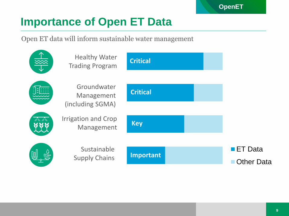
Importance of Open ET Data
9
Open ET data will inform sustainable water management
ET Data
Other Data
Critical
Key
Important
Critical Healthy Water
Trading Program
Irrigation and Crop Management
Sustainable Supply Chains
Groundwater Management
(including SGMA)
OpenET

Proven Approach
4
Satellite Imagery + Ground-based Weather Data + Advanced Analytics
Evapotranspiration
OpenET
Satellite Archives Consumptive Use

The Vision: An OpenET Software and Data Platform
• A web-based platform (OpenET) provides automated, and widely accessible ET data available to end users across the western U.S. for user-defined areas and time frames
• Open source software on GitHub so the water community can contribute, collaboratively code, or just look under the hood
OpenET
5

One Platform, Multiple Operational Models
6

Initial Case Study Locations
12
McDonald Island, CA
Upper Colorado River Basin
Colusa GW Subbasin
Diamond Valley, NV
CA Almond Board
Pinal County, AZ
Tulare County, CA
Rosedale-Rio-Bravo W.S.D.
Butte GW Subbasin
Legend: Approved
Proposed
OpenET
Arizona DWR
Groundwater Management
Water Trading
Irrigation and Crop Mgmt

NASA ASP Project Stakeholders and Study Locations
NASA Applied Sciences Program – Water Resources: DRI/NASA ET Project • Goal - Enable agency staff to gain a thorough
understanding of models, assumptions and limitations, software operation and post-processing, and ultimately sustain in-house ET mapping over the long-term
• Focus on specific study areas for software development, testing, training, and initial implementation

Moving Past Engagement to Trainings
• The days of “loading dock science” are gone…
• Open sharing of codes and trainings on how to use the codes and web applications is a must if we want end users to actually adopt our products
NASA/DRI ET Workshop with 21 state water agency staff from 8 western states Funded by NASA ROSES ASP Western States Remote Sensing of ET Project
September 12-15, 2017 – DRI computer lab
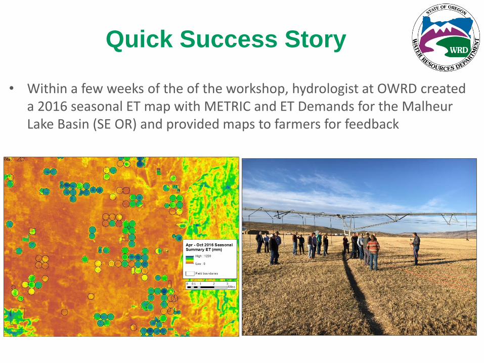
Quick Success Story
• Within a few weeks of the of the workshop, hydrologist at OWRD created a 2016 seasonal ET map with METRIC and ET Demands for the Malheur Lake Basin (SE OR) and provided maps to farmers for feedback

Our First Test
• Regional scale field level ET mapping on Google Earth Engine
• Example collaboration with Gabriel Senay, MacKenzie Friedrichs, and others at USGS EROS
2015 annual ET - 16,000 Landsat images processed over a weekend

Desired Breakthroughs
• For multiple ET research teams and water agencies to contribute to OpenET via the GitHub version control software – Goal of advancing science and providing
end users with free to low cost ET data via a state-of-the-art web application
• Ensemble water use mapping to better understand model differences and co-variates in space and time – Climate models
– Hydrologic models
– Land cover land use
– Why not ET models?... now that we can!

How can ET help Groundwater Management?
9
• Provide ability to assess 30+ years of water use (1984-current)
• Develop a more complete picture of baseline water consumption
• Complement groundwater pumpage inventories / metering program
• Fill in gaps in groundwater pumpage data
• Provide a backup and independent assessment of consumptive use
• Ability to assess within field variability / stressed / water short areas
• Provide readily available data to track and illustrate decreases in consumptive use as groundwater management plans are acted on
• Provide 7 day forecasts of reference ET / evaporative demand to improve irrigation scheduling
• Other ideas?
OpenET

Example Interface - Climate Engine - app.climateengine.org On-Demand Cloud Computing and Visualization of Climate and Remote Sensing Data


On-demand spatial averaging in time and plotting -Time Series for 2014 – Alfalfa Field in Central Valley, CA

• Remote sensing is the only way to estimate actual ET over large areas and long time
histories
• Field scale satellite archives combined with availability of climate data and cloud computing is creating transformative opportunities
• Rapid processing and visualization tools for simple consumptive use decision support • Will allow for all to perform field scale consumptive use analyis
• Free and open access to objective data where everyone is treated equally will reduce the likelihood for disputes over data or lack of data
• Outreach through hands-on training is key for adoption
• Contact [email protected] if interested in participating or for more details
OpenET
Summary

Acknowledgements
Huntington, J. L., K. C. Hegewisch, B. Daudert, C. G. Morton, J. T. Abatzoglou, D. J.McEvoy, and T. Erickson. 2017. Climate Engine: cloud computing and visualization of climate and remote sensing data for advanced natural resource monitoring and process understanding. Bulletin of the American Meteorological Society.
November Issue of BAMS - climateengine.org

Program Design/Execution
7
OpenET