jaunpur district falls in the varanasi division of uttar … brief industrial profile of jaunpur...
TRANSCRIPT

1
Contents
S. No.
Topic Page No.
1. General Characteristics of the District 2 1.1 Location & Geographical Area 2 1.2 Topography 3 1.3 Availability of Minerals. 3-4 1.4 Forest 4 1.5 Administrative set up 4 2. District at a glance 4-8 2.1 Existing Status of Industrial Area in the District Mau. 8 3. Industrial Scenario Of Mau. 8
3.1 Industry at a Glance 8 3.2 Year Wise Trend Of Units Registered 9 3.3 Details Of Existing Micro & Small Enterprises & Artisan Units In The
District Mau. 10
3.4 Large Scale Industries / Public Sector undertakings 10 3.4.1 List of units 10 3.4.2 Major Exportable Item 10 3.4.3 Growth Trend 10 3.4.4 Vendorisation / Ancillarisation of the Industry 11 3.5 Medium Scale Enterprises 11 3.5.1 List of the units in Mau & near by Area 11 3.5.2 Major Exportable Item 11 3.6 Service Enterprises 11 3.6.1 Present Status 11 3.6.2 Potentials areas for service industry 11 3.7 Potential for new MSMEs 11 4. Existing Clusters of Micro & Small Enterprise 11 4.1 Detail Of Major Clusters 11 4.1.1 Manufacturing Sector 11 4.1.2 Service Sector 12 4.2 Details of Identified cluster 12 4.2.1 Name of the Cluster- 12 5. General issues raised by industry association during the course of
meeting 12
6 13 Steps to set up MSMEs

2
Brief Industrial Profile of Jaunpur District
1. General Characteristics of the District:
Jaunpur district falls in the Varanasi division of Uttar Pradesh. Jaunpur town serves as the district
headquarters. The district has been divided into 6 Tehsils and 21 development Blocks in order to
speedy implementation of the developmental schemes. Total population of the district is
4,476,072 with a population density of 1,108 / Sq.Km. and literacy rate is 73.66%
.In 2006 the Ministry of Panchayati Raj named Jaunpur one of the country's 250 most backward
districts. It is one of the 34 di stricts in Uttar Pradesh currently receiving funds from the
Backward Regions Grant Fund Programme (BRGF).
1.1 Location & Geographical Area:
The district of Jaunpur is situated in the North-west part of Varanasi division. Its land area
extends from 24.240N to 26.120N latitude and between 82.70E and 83.50E longitude. The
geographical area of the district is 4038 KM2. As depicted in the following map, the district is
bounded by the Sultanpur to its North, Azamgarh to North-East, Ghazipur to East,Varanasi to its
South-East, Sant Kabir nagar to the South, Allahabad to the South- West and Pratapgarh to the
West.

3
1.2 TOPOGRAPHY:
Its altitude varies from 261 ft to 290 ft above MSL (Mean sea level. The topography of
the district is mainly a flat plain with shallow river- balleys. Gomti & sai are its main
perennial rivers. Besides these, Varuna, Basuhi, Pili, Mamur, & Gangi are the smaller
rivers. The rivers Gomti & Basuhi divide the district into nearly four equal landmasses.
The soil is mainly sandy and Loamy. District is often affected by the floods during rainy
seasons.
1.3 Availability of Minerals:
The district is extremely poor in mineral deposits. Lime stones and Kankar are found at
some places which are burnt to make lime. The lime thus obtained is used in building
construction work.

4
PRODUCTION OF MINERAL 2010-11
NAME OF MINERAL PRODUCTION in tones 2010-2011
N I L SOURCE: - DEPT. OF MINES & GEOLOGY,
1.4 Forest:
District, Jaunpur mainly plain area and it is having only 99 Hectares of forest cover.
1.5 Administrative set up.
Jaunpur district has 6 tahsils—Shahganj, Badlapur, Machhali Shahar, Jaunpur, Mariyahu and
Kerakat, 3 Lok Sabha constituencies and 10 Vidhan Sabha constituencies . The district has been
divided into 21 Development Blocks.Jaunpur town is the district headquarters.
2. District at a glance
S.No Particular Year Unit Statistics
1 Geographical features
(A) Geographical Data 2011 SqKM 4038
i) Latitude 2011 Degree 25.24 To26.12
North
ii) Longitude 2011 Degree 82.7 To 83 .5
East
iii) Geographical Area 2011 Hectares 403906.575
(B) Administrative Units
i) Sub divisions 2012 No --
ii) Tehsils 2012 No 06
iii) Sub-Tehsil 2012 No --
iv) Patwar Circle(Blocks) 2012 No 21
v) Panchayat Simitis 2012 No 1514
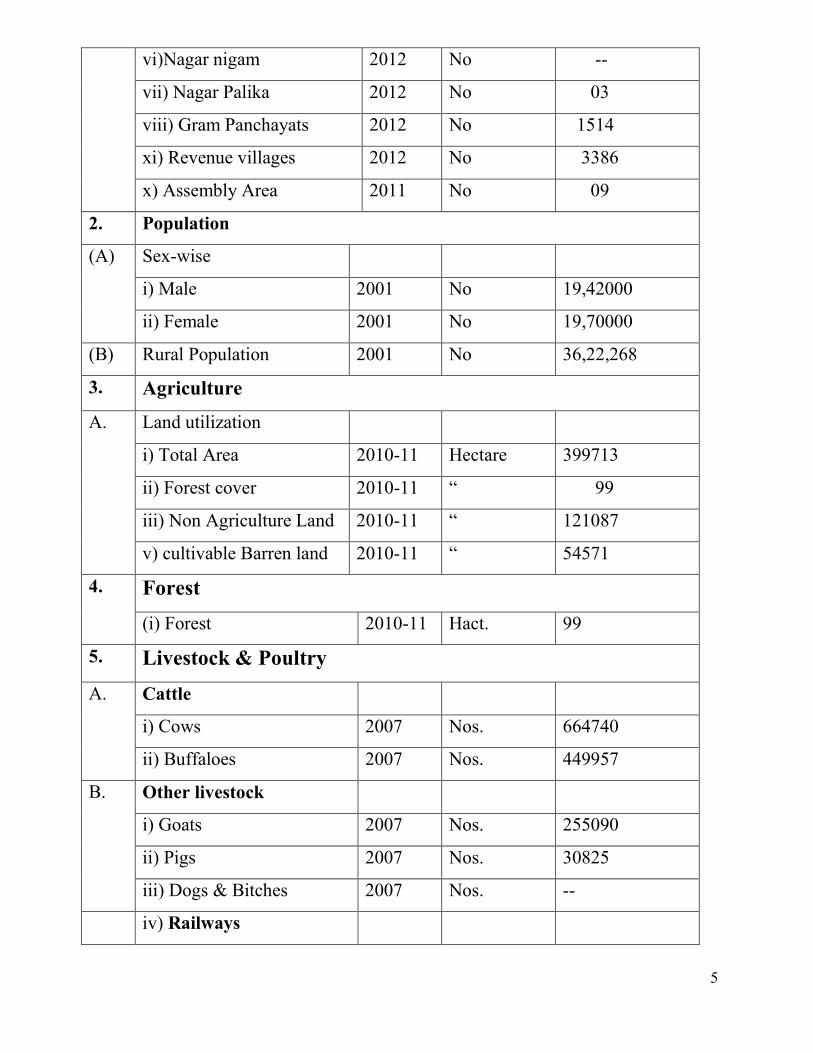
5
vi)Nagar nigam 2012 No --
vii) Nagar Palika 2012 No 03
viii) Gram Panchayats 2012 No 1514
xi) Revenue villages 2012 No 3386
x) Assembly Area 2011 No 09
2. Population
(A) Sex-wise
i) Male 2001 No 19,42000
ii) Female 2001 No 19,70000
(B) Rural Population 2001 No 36,22,268
3. Agriculture
A. Land utilization
i) Total Area 2010-11 Hectare 399713
ii) Forest cover 2010-11 “ 99
iii) Non Agriculture Land 2010-11 “ 121087
v) cultivable Barren land 2010-11 “ 54571
4. Forest (i) Forest 2010-11 Hact. 99
5. Livestock & Poultry A. Cattle
i) Cows 2007 Nos. 664740
ii) Buffaloes 2007 Nos. 449957
B. Other livestock
i) Goats 2007 Nos. 255090
ii) Pigs 2007 Nos. 30825
iii) Dogs & Bitches 2007 Nos. --
iv) Railways
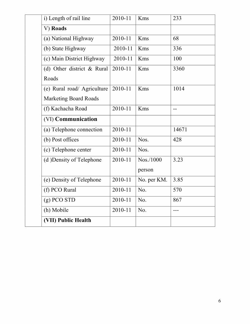
6
i) Length of rail line 2010-11 Kms 233
V) Roads
(a) National Highway 2010-11 Kms 68
(b) State Highway 2010-11 Kms 336
(c) Main District Highway 2010-11 Kms 100
(d) Other district & Rural
Roads
2010-11 Kms 3360
(e) Rural road/ Agriculture
Marketing Board Roads
2010-11 Kms 1014
(f) Kachacha Road 2010-11 Kms --
(VI) Communication
(a) Telephone connection 2010-11 14671
(b) Post offices 2010-11 Nos. 428
(c) Telephone center 2010-11 Nos.
(d )Density of Telephone 2010-11 Nos./1000
person
3.23
(e) Density of Telephone 2010-11 No. per KM. 3.85
(f) PCO Rural 2010-11 No. 570
(g) PCO STD 2010-11 No. 867
(h) Mobile 2010-11 No. ---
(VII) Public Health

7
(a) Allopathic Hospital
(b) Beds in Allopathic
hospitals
(c) Ayurvedic Hospital
(d) Beds in Ayurvedic
hospitals
(e) Unani hospitals
(f) Community health
centers
(g) Primary health
centers
(h) Dispensaries
(i) Sub Health Centers
(j) Private hospitals
2010-11 No.
No.
No.
No.
No.
No.
No.
No.
No.
No.
09
819
36
159
09
13
83
--
503
---
(VIII) Banking
commercial
(a) Commercial Bank Nos. 114
(b) rural Bank Products Nos. 89
(c) Co-Operative bank
products
Nos. 29
(d) PLDB Branches Nos. 05
(IX) Education
(a) Primary school Nos. 2409
(b) Middle schools Nos. 881
(c) Secondary & senior
secondary schools
Nos. 443
(d) Colleges Nos. 31

8
(e) Technical University Nos. 01
2.1 Existing Status of Industrial Areas in the District Jaunpur
S.
No.
Name of Ind.
Area Land
acquired
(In
hectare)
Land
developed
(In
hectare)
Prevailing
Rate Per
Sqm
(In Rs.)
No of
Plots
No of
allotted
Plots
No of
Vacant
Plots
No. of
Units in
Production
1 Satariya Indl
.Development
Authority
( SIDA)
508
Acre
508
Acre
1000/sq mtr 465 465 nil 110
2
Sidhwan
50
Acre
50
Acre
900/Sq mtr. 60 41 19 21
Source:- RIICO,
3. Industrial Scenario of Jaunpur
3.1 Industry at a Glance Sr
No Head Unit Particulars
1. REGISTERED INDUSTRIAL UNIT NO. 10422
2. TOTAL INDUSTRIAL UNIT NO. 10422
3. REGISTERED MEDIUM & LARGE UNIT NO. -----
4. ESTIMATED AVG. NO. OF DAILY
WORKER EMPLOYED IN SMALL
SCALE INDUSTRIES
NO. 2053
5. EMPLOYMENT IN LARGE AND
MEDIUM INDUSTRIES NO. -------
6. NO. OF INDUSTRIAL AREA NO. 02
7. TURNOVER OF SMALL SCALE IND. IN LACS 14145
8. TURNOVER OF MEDIUM & LARGE
SCALE INDUSTRIES IN LACS -----
9
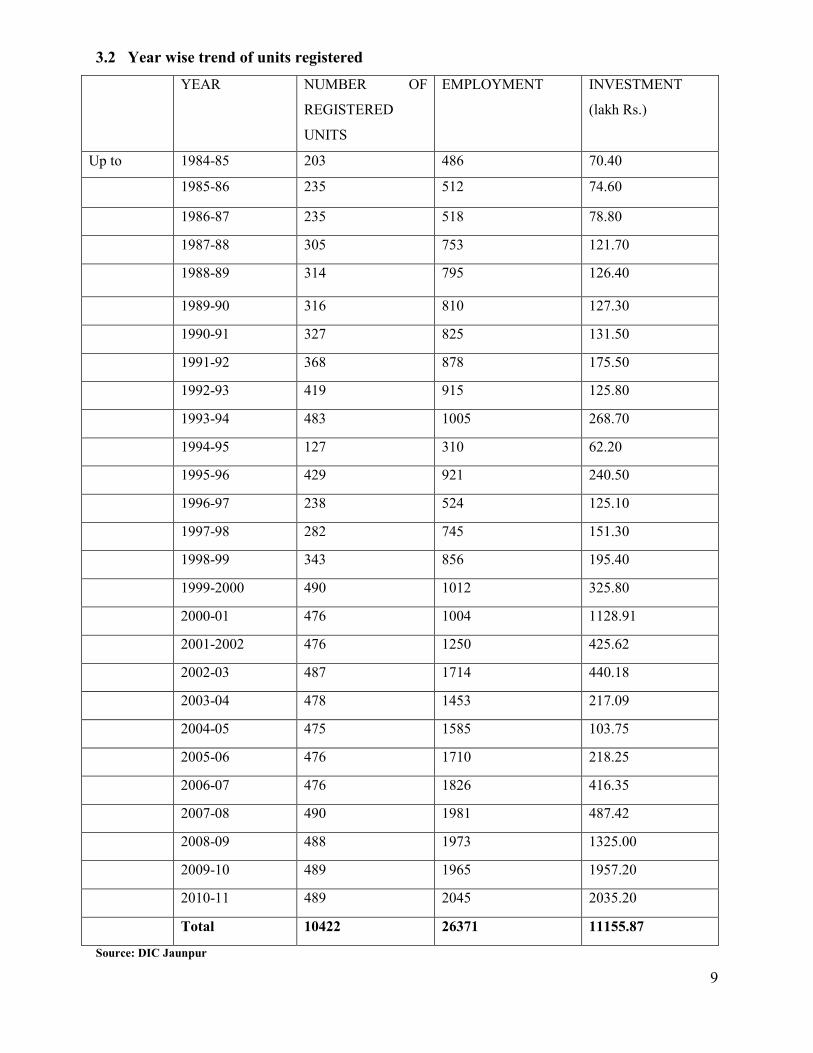
3.2 Year wise trend of units registered
YEAR NUMBER OF
REGISTERED
UNITS
EMPLOYMENT INVESTMENT
(lakh Rs.)
Up to 1984-85 203 486 70.40
1985-86 235 512 74.60
1986-87 235 518 78.80
1987-88 305 753 121.70
1988-89 314 795 126.40
1989-90 316 810 127.30
1990-91 327 825 131.50
1991-92 368 878 175.50
1992-93 419 915 125.80
1993-94 483 1005 268.70
1994-95 127 310 62.20
1995-96 429 921 240.50
1996-97 238 524 125.10
1997-98 282 745 151.30
1998-99 343 856 195.40
1999-2000 490 1012 325.80
2000-01 476 1004 1128.91
2001-2002 476 1250 425.62
2002-03 487 1714 440.18
2003-04 478 1453 217.09
2004-05 475 1585 103.75
2005-06 476 1710 218.25
2006-07 476 1826 416.35
2007-08 490 1981 487.42
2008-09 488 1973 1325.00
2009-10 489 1965 1957.20
2010-11 489 2045 2035.20
Total 10422 26371 11155.87 Source: DIC Jaunpur
10
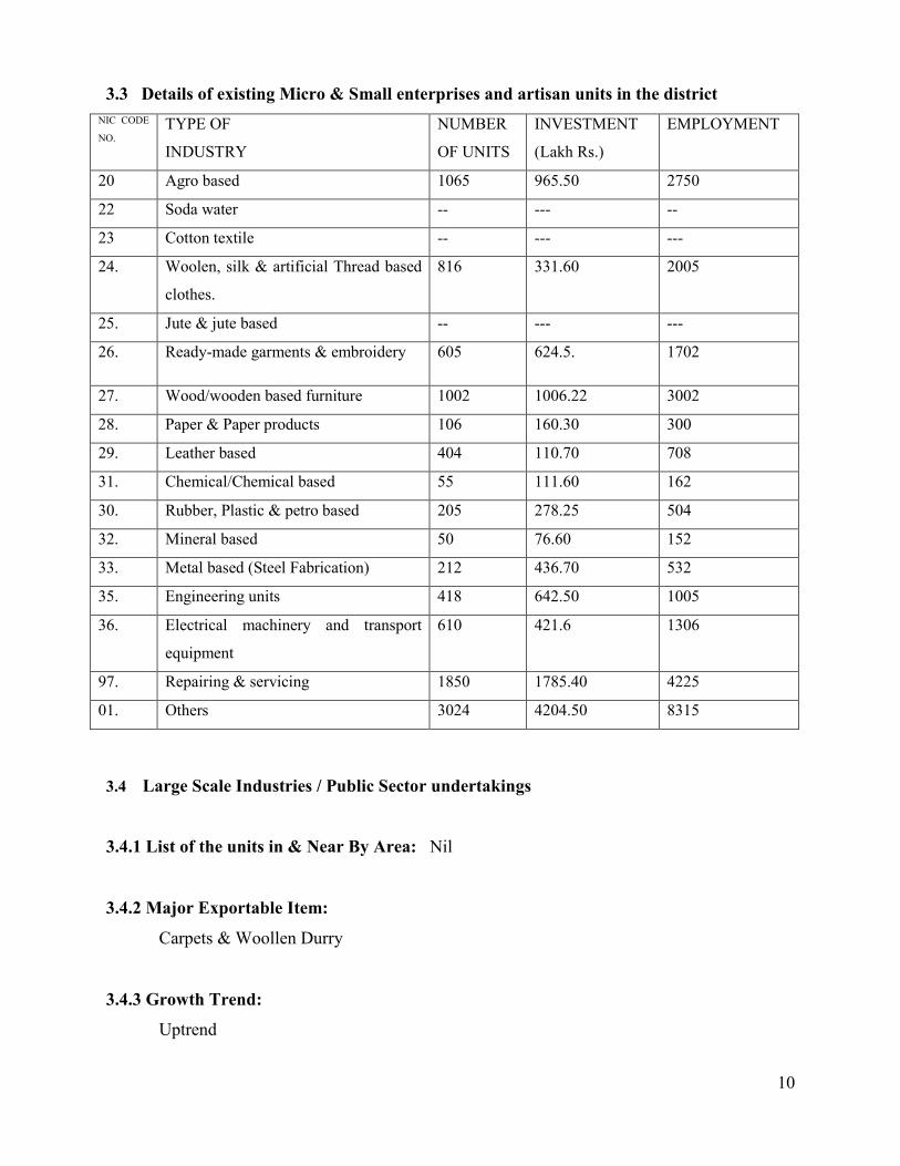
3.3 Details of existing Micro & Small enterprises and artisan units in the district NIC CODE
NO. TYPE OF INDUSTRY
NUMBER
OF UNITS INVESTMENT
(Lakh Rs.) EMPLOYMENT
20 Agro based 1065 965.50 2750 22 Soda water -- --- -- 23 Cotton textile -- --- --- 24. Woolen, silk & artificial Thread based
clothes. 816 331.60 2005
25. Jute & jute based -- --- --- 26. Ready-made garments & embroidery 605 624.5. 1702
27. Wood/wooden based furniture 1002 1006.22 3002 28. Paper & Paper products 106 160.30 300 29. Leather based 404 110.70 708 31. Chemical/Chemical based 55 111.60 162 30. Rubber, Plastic & petro based 205 278.25 504 32. Mineral based 50 76.60 152 33. Metal based (Steel Fabrication) 212 436.70 532 35. Engineering units 418 642.50 1005 36. Electrical machinery and transport
equipment 610 421.6 1306
97. Repairing & servicing 1850 1785.40 4225 01. Others 3024 4204.50 8315
3.4 Large Scale Industries / Public Sector undertakings
3.4.1 List of the units in & Near By Area: Nil
3.4.2 Major Exportable Item:
Carpets & Woollen Durry
3.4.3 Growth Trend:
Uptrend
11
3.4.4 Vendorisation / Ancillarisation of the Industry:
Nil
3.5 Medium Scale Enterprises
3.5.1 List of the units in Jaunpur & Near By Area
Nil
3.5.2 Major Exportable Item:
Nil
3.6 Service Enterprises
3.6.1 Present Status
In order to meet the local requirements such service enterprises asrestaurants,dhabas,DTP
Centers, Internet Caffe, Photo Copy Centers, Mobile repair shops, Tent Houses, Nursing Homes
etc. have come up, 3.6.2 Potentials areas for service industry:
Packing industry, automobile service centre, Offset Printing press.
3.7 Potential for new MSMEs:
Food based Industries & Agro based Industries ,
4. Existing Clusters of Micro & Small Enterprise 4.1 Detail of Major Clusters:
4.1.1 Manufacturing Sector :
One at Mariyahu based on Woollen Durry.

12
4.1.2 Service Sector
Nil
4.2 Details for Identified cluster
4.2.1 Name of the cluster: Woolen Durry at Mariyahun
1 Principal Products Manufactured in
the Cluster Woollen Durry
2 Name of the SPV Shri Aftab Alam 3 No. of functional units in the clusters 200 Families 4 Turnover of the Clusters Yet to be take ascertaine 5 Value of Exports from the Clusters Only soft intervention has taken place, export yet to
be take place 6 Employment in Cluster 400 7 Average investment in plant &
Machinery 12 lakhs to 14 lakhs
8 Major Issues / requirement
Land is yet to be transferred in favor of SPV,
SIDBI apprise is required
9 Presence of capable institutions Indian Institute of Carpet technology, Bhadohi 10 Thrust Areas Technological Up gradation, Process improvement 11 Problems & constraints Land is yet to be transferred in favor of SPV,
Present status of the cluster:
DPR for CFC has been submitted seeking financial assistance under MSE - CDP of Ministry of
MSME,Govt India. In principle approval has been accorded.
5. General issues raised by industry association during the course of
meeting :
Power problem, Non availability of skilled man power,

13
6. Steps to set up MSMEs
Following are the brief description of different agencies for rendering assistance to the
entrepreneurs.
S.No Type of assistance Name and address of
agencies
1. Provisional Registration Certificate
( EM-1) & Permanent Registration
Certificate ( EM-II)
DIC ,Jaunpur
2. Identification of Project Profiles, techno-
economic and managerial consultancy
services, market survey and economic
survey reports.
MSME-DI Allahabad
D I C jaunpur
3. Land and Industrial shed U P S I D C, Allahabad
D I C Jaunpur
4. Financial Assistance SIDBI, Banks,
5. For raw materials under Govt. Supply NSIC Allahabad
6. Plant and machinery under hire / purchase
basis.
NSIC Allahabad
7. Power/ Electricity UP Power Corporation
8. Technical Know –how. MSMEDI Allahabad

14
DIC Jaunpur
9. Quality & Standard MSMEDI Allahabad
DIC Jaunpur
10. Marketing /Export Assistance MSMEDI Allahabad
DIC Jaunpur
11. Other Promotional Agencies Engg colleges university
at Jaunpur & at Varanasi