jocassee journal - south carolina
TRANSCRIPT

Spring/Summer 2016 Volume 17, Number 1
Jocassee Journal www.dnr.sc.govInformation and News about the Jocassee Gorges
Sassafras observation tower moving closer to reality
Initial phase will include restrooms The long-awaited observation tower atop Sassafras Mountain, South Carolina’s highest point, may be well underway by the end of 2016. Plans have been completed for the observation structure that will be built to straddle the peak at 3,553 feet above sea level. Gil L. Stewart Architects LLC of Pickens drafted the design and is working in conjunction with Professional Engineering Associates of Greenville. Bids for construction are expected to go out by Aug. 15, and with a two-month bid process, construction could begin by mid-October. Completion of the project is expected to take about six months. The viewing tower will offer an unparalleled view of the Blue Ridge Mountains of South Carolina, North Carolina and Georgia. The initial phase, for which more than $500,000 has been raised, will include the observation tower and restrooms. A more comprehensive
project, for which additional funding will need to be raised, will include improvements to the parking area, a picnic facility, accessory trails, informational kiosks and educational pavilions. Duke Energy, the S.C. Department of Natural Resources (DNR), The Harry Hampton Memorial Wildlife Fund, The Felburn Foundation and anonymous donors have contributed toward the project. DNR is still seeking major donations to complete the comprehensive improvements on Sassafras Mountain that will provide a special educational opportunity for school children of all ages. In addition to being the highest point in South Carolina at 3,553 feet, Sassafras Mountain sits on the state line with North Carolina, is along the Continental Divide, and is one of the important features of the Foothills Trail (www.foothillstrail.org), a 77-mile footpath between Table Rock and Oconee state parks.
The Sassafras Mountain viewing tower will offer an unparalleled view of the Blue Ridge Mountains. The anticipated final version of the tower is shown here in an architectural rendering by Gil L. Stewart.
2
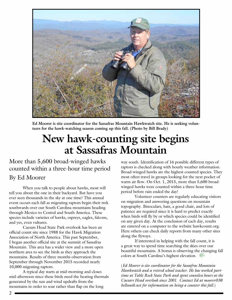
More than 5,600 broad-winged hawks counted within a three-hour time periodBy Ed Moorer
When you talk to people about hawks, most will tell you about the one in their backyard. But have you ever seen thousands in the sky at one time? This annual event occurs each fall as migrating raptors begin their trek southwards over our South Carolina mountains heading through Mexico to Central and South America. These species include varieties of hawks, ospreys, eagles, falcons, and yes, even vultures. Caesars Head State Park overlook has been an official count site since 1988 for the Hawk Migration Association of North America. This past September, I began another official site at the summit of Sassafras Mountain. This area has a wider view and a more open northern area to see the birds as they approach the mountains. Results of three months observation from September through November 2015 recorded nearly 10,000 migrating raptors. A typical day starts at mid-morning and closes mid-afternoon since these birds need the heating thermals generated by the sun and wind updrafts from the mountains in order to soar rather than flap on the long
way south. Identification of 16 possible different types of raptors is checked along with hourly weather information. Broad-winged hawks are the highest counted species. They most often travel in groups looking for the next pocket of warm air flow. On Oct. 1, 2015, more than 5,600 broad-winged hawks were counted within a three-hour time period before rain ended the day! Volunteer counters are regularly educating visitors on migration and answering questions on mountain topography. Binoculars, hats, a good chair, and lots of patience are required since it is hard to predict exactly when birds will fly by or which species could be identified on any given day. At the conclusion of each day, results are entered on a computer to the website hawkcount.org. Here others can check daily reports from many other sites along the flyways. If interested in helping with the fall count, it is a great way to spend time searching the skies over our beautiful mountains. A bonus is observing the changing fall colors at South Carolina’s highest elevation.
(Ed Moorer is site coordinator for the Sassafras Mountain Hawkwatch and a retired school teacher. He has worked part-time at Table Rock State Park and spent countless hours at the Caesars Head overlook since 2001. Contact Ed at [email protected] for information on being a counter this fall.)
New hawk-counting site begins at Sassafras Mountain
Ed Moorer is site coordinator for the Sassafras Mountain Hawkwatch site. He is seeking volun-teers for the hawk-watching season coming up this fall. (Photo by Bill Brady)
3
Scientists will begin three-year study of winter loons on Lake Jocassee
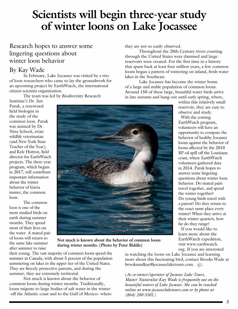
Research hopes to answer some lingering questions about winter loon behaviorBy Kay Wade In February, Lake Jocassee was visited by a trio of loon researchers who came to lay the groundwork for an upcoming project by EarthWatch, the international citizen scientist organization. The team was led by Biodiversity Research Institute’s Dr. Jim Paruk, a renowned field biologist in the study of the common loon. Paruk was assisted by Dr. Nina Schock, avian wildlife veterinarian (and New York State Teacher of the Year), and Kyle Hutton, field director for EarthWatch projects. The three-year program, which begins in 2017, will contribute important information about the winter behavior of Gavia immer, the common loon. The common loon is one of the most studied birds on earth during summer months. They spend most of their lives on the water. A mated pair of loons will return to the same lake summer after summer to raise their young. The vast majority of common loons spend the summer in Canada, with about 5 percent of the population summering on lakes in the upper tier of the United States. They are fiercely protective parents, and during the summer, they are extremely territorial. Not much is known about the behavior of common loons during winter months. Traditionally, loons migrate to large bodies of salt water in the winter--off the Atlantic coast and to the Gulf of Mexico--where
they are not so easily observed. Throughout the 20th Century rivers coursing through the United States were dammed and large reservoirs were created. For the first time in a history that spans back at least four million years, a few common loons began a pattern of wintering on inland, fresh water lakes in the Southeast. Lake Jocassee has become the winter home of a large and stable population of common loons. Around 150 of these large, beautiful water birds arrive in late autumn and hang out until early spring, where,
within this relatively small reservoir, they are easy to observe and study. With the coming EarthWatch program, volunteers will have an opportunity to compare the behavior of healthy Jocassee loons against the behavior of loons affected by the 2010 BP oil spill off the Louisiana coast, where EarthWatch volunteers gathered data in 2014. Paruk hopes to answer some lingering questions about winter loon behavior. Do mated pairs travel together, and spend the winter together? Do young birds travel with a parent? Do they return to the exact same place every winter? When they arrive at their winter quarters, how far do they range? If you would like to learn more about the EarthWatch expedition, visit www.earthwatch.org. If you are interested
in watching the loons on Lake Jocassee and learning more about this fascinating bird, contact Brooks Wade at [email protected].
(As co-owner/operator of Jocassee Lake Tours, Master Naturalist Kay Wade is frequently out on the beautiful waters of Lake Jocassee. She can be reached online at www.jocasseelaketours.com or by phone at (864) 280-5501.)
Not much is known about the behavior of common loons during winter months. (Photo by Peter Biddle)

4
The design Drew Boggs came up with for a cistern will likely be a model for any future improvements to Foothills Trail water sources. (Photos by Heyward Douglass)
Eagle Scout improves water availability on Foothills Trail with innovative cistern
Design likely a model for future improvements to trail water sources
Although water is generally plentiful along the Foothills Trail, there are places that the source itself leaves something to be desired, either in its accessibility or in the depth of the water, or both. Several members of the Foothills Trail Conference took it upon themselves a few years ago to dig out the spring at the Cantrell homesite and line it with rock to make a pool of clean, clear water. This was well-received by those using the campsite. Since this proved to be successful, Heyward Douglass, Foothills Trail Conference executive director, kept his ear open for a suitable Boy Scout to come along and need a worthwhile project for his Eagle badge. A chance conversation with Billy Boggs of Seneca, former long-time scoutmaster of Troop 120, put Douglass in touch
with Boggs’ grandson, Drew Boggs, and an agreement was forged. After receiving the OK from the S.C. Department of Natural Resources and Duke Energy, which manage the sections where the project was to take place, Drew Boggs and Billy Boggs accompanied Douglass to look at the possible sites for these improved water sources. The necessary “before” pictures were made at each of the places that were being considered. Drew came up with a design for a cistern that will likely be a model for any future improvements to trail water sources. Rather than a rock lining, which is subject to caving in or filling with debris, he chose to use a 12-inch diameter, black plastic pipe to which he added a concrete cover with a handle. Once the stream or spring is dug out to a suitable depth, the pipe (with holes in the sides) is inserted in the hole and the cover, which acts like a stopper, is placed on top. Very shortly the cistern fills with good, clear, clean water that any hiker would be glad to dip into–but should still filter or treat. Drew also placed marker posts near the improved sites to direct hikers to the cisterns–in each case with a reflective material added for those that arrive after dark. These improved water sources were put in at sites near Sassafras Mountain, Chimneytop Gap, Laurel Valley designated campsite, and the designated campsite near Bad Creek Hydro Project. If you are hiking near these sites stop and take a look or fill up your water bottle!
Drew Boggs

5
New Year’s takes on special meaning at Oconee State Park
Author counts blessings for passing of another yearBy Odell Suttle
Everyone has their own way of bringing in the New Year. Sadie, my wife, and I like to rent cabin 16 in Oconee State Park and at 11:50 p.m. New Year’s Eve, we leave the cabin and go for a hike around the lake. We get back to cabin 16 at 15 minutes past midnight therefore we are on the trail when the New Year arrives. We are actually at the halfway point of the trail and sitting on the bench there at the stroke of midnight. We have done this for three consecutive years.
Sadie has a flashlight that has four D-cell batteries; the flashlight has a three-and-a-half-inch face. I have a headlamp and I walk in front of her. We have the trail lit up very well.We have never met any wildlife on the trail in our three trips around the lake. It is quiet and refreshing out there in the dark, except for our lights. Once back in the cabin, we drink hot chocolate and say a prayer thanking the Lord for the park and cabin and for one more year of good weather. It is much safer in the park than being out on the highway.
(Odell Suttle is a life-long resident of Fountain Inn, a Viet Nam veteran, a freelance writer and an avid mountain hiker.)
Ohio Wesleyan students help out on Foothills Trail
A group of 12 students and two faculty advisors from Ohio Wesleyan University came down from the school's home in Delaware, Ohio, and hiked for several days on the Foothills Trail, but the group also paid it forward by putting in two days of intensive volunteer work. Most of the work consisted of cleaning up and improving the designated campsite on the spur at Round Mountain Gap, but also dismantling some rogue fire rings. (Photos by Heyward Douglass)

6
Insect pollinators play an important role in Jocassee Gorges
The rare and beautiful Oconee bell reproduces vegetatively but can also reproduce sexually, through insect pollination. When hiking around during the spring, keep your open for bees and flies (above) visiting the flowers.
Many species of wildlife benefit from the fruit and seed that are producedBy Dr. Jennifer M. Tsuruda
Insect-pollinated agricultural crops have been estimated to be worth $20 billion in the United States. Insect pollinators also play a major role in natural ecosystems such as the Jocassee Gorges. Pollination can keep plant communities stable or help them flourish, which results in food and habitat for other animals. Wildlife, especially birds, benefits from the fruit and seed that are produced. Dead pollinators can also serve a role in the natural ecosystem by contributing to the nutrient content of the soil and being a food resource for scavengers and other insects, such as ants. In turn, several plants provide pollinators with nectar, a carbohydrate resource, and pollen, which is the major protein resource for pollinators. In the case of honey bees, the nectar is processed into honey, which is stored in honeycomb cells until needed in the winter, and the pollen is converted into royal jelly and food for developing bees. Flowering plants are necessary for their survival.
Pollinators are an important part of ecosystems, natural or agricultural, but they face several challenges. Depending on the environmental conditions, they may decline due to parasites, pathogens, predators, malnutrition, pesticide exposure, habitat loss/deterioration, or other factors. —Dr. Jennifer Tsuruda
While honey bees are the most widely used insect pollinator in agriculture, there are over 4,000 species of bees in North America. Some have long tongues (which the honey bee above is using to suck up nectar from the goldenrod flower), some have short tongues; some collect pollen on their legs, some collect pollen on hairs on their underside; some specialize on particular species of plants, some are generalists – the diversity of bees, and insect pollinators in general, is amazing. (Photo by Jennifer M. Tsuruda)

7
Insect pollinators play an important role in Jocassee Gorges
The rare and beautiful Oconee bell reproduces vegetatively but can also reproduce sexually, through insect pollination. When hiking around during the spring, keep your open for bees and flies (above) visiting the flowers.
While we often think of small flowering plants and shrubs as floral resources, trees can provide a lot of nourishment for insect pollinators due to the number of flowers they can put out on a single plant. Some trees you may want to keep your eyes open for, in terms of importance for pollinators, are maples, poplars, and sourwoods. Pollinators are an important part of ecosystems, natural or agricultural, but they face several challenges. Depending on the environmental conditions, they may decline due to parasites, pathogens, predators, malnutrition, pesticide exposure, habitat loss/deterioration, or other factors. There is a lot of research being in done in these areas but it will take time and there are still many questions to answer. Please do what you can and provide habitat and forage for insect pollinators, keeping in mind that many native flowers may not be as showy as horticultural varieties, but they may provide better or more food for pollinators. Also, reduce pesticide use to only the situations that require it. Most of all, be aware and learn more to fully appreciate the function and role of these animals in the ecosystem.
(Dr. Jennifer M. Tsuruda is Clemson University's Extension Apiculture Specialist and South Carolina’s state beekeeper, past president of the American Association of Professional Apiculturists, vice chairperson of the Heartland Apicultural Society, advisor to the South Carolina Farm Bureau's advisory committee on apiculture, and speaker at several state, regional, national, and international meetings and conferences.)
Pollinators are an important part of ecosystems, natural or agricultural, but they face several challenges. Depending on the environmental conditions, they may decline due to parasites, pathogens, predators, malnutrition, pesticide exposure, habitat loss/deterioration, or other factors. —Dr. Jennifer Tsuruda
While beetles are not as efficient at pollination as most bees and flies, their movement from flower to flower for feeding or mating purposes contributes to the movement of pollen. These longhorn beetles (locust borer longhorn beetle on left, goldenrod soldier beetle on right) use goldenrod for both food (pollen and nectar) and aggregation sites for mating. (Photo by Jennifer Tsuruda)

8
Devils Fork State Park turns 25Lake Jocassee jewel now averages 325,000 visitors a yearBy Jacob Gantt
The gateway to one of the crown jewels of the Carolinas, the Jocassee Gorges, will celebrate its silver anniversary as Devils Fork State Park turns 25 this year. After reaching this milestone, Devils Fork State Park looks forward to continuing to provide recreational opportunities and helping new generations make lasting memories. Opening in 1991, the park was a hidden treasure on Lake Jocassee for a few years, but as word spread, the park’s visitation increased. Over the past five calendar years, the park has had an average of over 325,000 visitors a year. The park currently offers 59 standard campsites, 13 boat-in only campsites, and 25 rustic walk-in tent sites. For folks looking for something a little less rustic, the park boasts 20 mountain villas with amenities such as heating and air, fireplaces, fully furnished kitchens, satellite TV and Wi-Fi. Devils Fork State Park has grown and evolved over the years, from the addition of the 25 rustic walk-in tent sites in the late 1990s to the more recent renovations to the villas. The original park office and
information center was converted into a meeting facility, and the original park store was renovated to not only be a retail outlet but also serves as the park’s ranger station. Ongoing improvements to the villa area will be the addition of outdoor living areas, where guests will be able to grill out and relax next to an outdoor fire. The future will present more challenges, but will also give opportunities for improvements such as an expansion to the trail system and the other enhancements that will improve the visitor’s experience.
(Jacob Gantt is a ranger at Devils Fork State Park on Lake Jocassee in Oconee County.)
Ongoing improvements to the villa area at Devils Fork State Park will be the addition of outdoor living areas, where guests will be able to grill out and relax next to an outdoor fire.
Devils Fork State Park looks out on one of the most beautiful vistas in South Carolina, including Lake Jocassee and the Blue Ridge.

9
S.C. State Forester wins prestigious Gifford Pinchot
MedalJocassee Gorges bear hunter honored for lifelong commitment, contributions to forestry South Carolina State Forester Gene Kodama has been awarded the Society of American Foresters’ Gifford Pinchot Medal. One of the most esteemed forestry awards in the nation, the medal is presented every two years to a forestry professional in recognition of exceptional contributions to the administration, practice and development of forestry in North America. “The American Society of Foresters got it right when they selected Gene Kodama for this prestigious award,” said Dennis Chastain, Upstate hunter, naturalist and author. “I have known Gene for twenty years, and we have become especially close friends after bear hunting together in the Jocassee Gorges for the past eight years. I know first-hand that Gene Kodama personifies many of those very qualities of Gifford Pinchot, America’s first forester. “He is not only an exemplary manager of the S.C. Forestry Commission, and an effective advocate for our forests and the forest products industry, Gene possesses a quality that is sometimes found lacking among some in the field. Gene Kodama understands where our forests fit into the larger natural world. He understands that our forests are more than the trees they contain. He knows that they are home to an incredible diversity of wildlife, and that the future of wildlife is intimately linked to the future of our forests. “And knowing Gene as I do, I am convinced that it is his experience as a life-long hunter, from the woods around Moncks Corner where he grew up to the highest peaks of the Jocassee Gorges, that has given him this broader perspective. If you spend enough time in a deer stand, or stalking wild hogs through a black-water swamp, or pursuing bears in the deep woods of the mountains, you eventually achieve a level of understanding of how the natural world
works that others can only hope to attain.” Nominees for the Gifford Pinchot Medal must have demonstrated exemplary actions that further the field of forestry by making an indelible mark on the profession and being a person of action. Endorsements for Kodama’s nomination came from multiple state, national and international leaders in forestry and the forest products industries. Gifford Pinchot is widely credited as being America's first forester and the father of the conservation
movement in North America. In 1892 Pinchot began the first systematic forest management plan in North America on the Biltmore estate in North Carolina. Seeing a need for a national resource management organization, Pinchot brought about the establishment of the Forest Service in 1898 with the help of President Theodore Roosevelt. The National Forest system and forest policy as we know them today are a result of Pinchot's efforts. In addition
to establishing the Forest Service, Pinchot founded the Society of American Foresters in 1900. He served as its president from 1900-08 and again from 1910-11. He was elected an SAF Fellow in 1918. Gifford Pinchot brought a professional approach to all his endeavors, the Forest Service, natural resource conservation, and the SAF. His actions have left an indelible mark on the profession of natural resource management.
State Forester Gene Kodama is shown with the black bear that he harvested in Jocassee Gorges Oct. 17, 2012. Kodama recently received the Gifford Pinchot Medal, one of the most esteemed forestry awards in the nation.
10
Trout Unlimited donates $10,000 to DNR brook trout genetics study
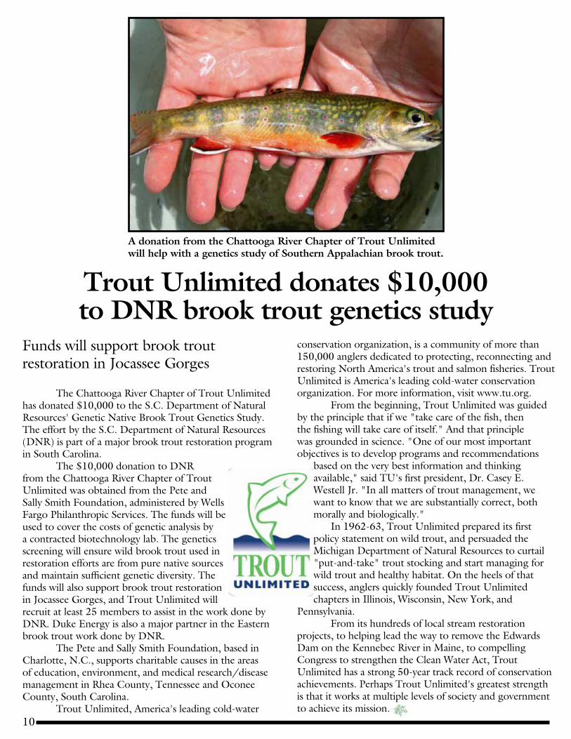
A donation from the Chattooga River Chapter of Trout Unlimited will help with a genetics study of Southern Appalachian brook trout.
Funds will support brook trout restoration in Jocassee Gorges
The Chattooga River Chapter of Trout Unlimited has donated $10,000 to the S.C. Department of Natural Resources' Genetic Native Brook Trout Genetics Study.The effort by the S.C. Department of Natural Resources (DNR) is part of a major brook trout restoration program in South Carolina. The $10,000 donation to DNR from the Chattooga River Chapter of Trout Unlimited was obtained from the Pete and Sally Smith Foundation, administered by Wells Fargo Philanthropic Services. The funds will be used to cover the costs of genetic analysis by a contracted biotechnology lab. The genetics screening will ensure wild brook trout used in restoration efforts are from pure native sources and maintain sufficient genetic diversity. The funds will also support brook trout restoration in Jocassee Gorges, and Trout Unlimited will recruit at least 25 members to assist in the work done by DNR. Duke Energy is also a major partner in the Eastern brook trout work done by DNR. The Pete and Sally Smith Foundation, based in Charlotte, N.C., supports charitable causes in the areas of education, environment, and medical research/disease management in Rhea County, Tennessee and Oconee County, South Carolina. Trout Unlimited, America's leading cold-water
conservation organization, is a community of more than 150,000 anglers dedicated to protecting, reconnecting and restoring North America's trout and salmon fisheries. Trout Unlimited is America's leading cold-water conservation organization. For more information, visit www.tu.org. From the beginning, Trout Unlimited was guided by the principle that if we "take care of the fish, then the fishing will take care of itself." And that principle was grounded in science. "One of our most important objectives is to develop programs and recommendations
based on the very best information and thinking available," said TU's first president, Dr. Casey E. Westell Jr. "In all matters of trout management, we want to know that we are substantially correct, both morally and biologically." In 1962-63, Trout Unlimited prepared its first policy statement on wild trout, and persuaded the Michigan Department of Natural Resources to curtail "put-and-take" trout stocking and start managing for wild trout and healthy habitat. On the heels of that success, anglers quickly founded Trout Unlimited chapters in Illinois, Wisconsin, New York, and
Pennsylvania. From its hundreds of local stream restoration projects, to helping lead the way to remove the Edwards Dam on the Kennebec River in Maine, to compelling Congress to strengthen the Clean Water Act, Trout Unlimited has a strong 50-year track record of conservation achievements. Perhaps Trout Unlimited's greatest strength is that it works at multiple levels of society and government to achieve its mission.

11
More participants sought for backyard weather observation
Network provided important precipitation totals during historic October 2015 flood
Carolina’s Community Collaborative Rain, Hail and Snow Network is a grassroots volunteer network of backyard weather observers of all ages and backgrounds working together to measure and map precipitation (rain, hail, and snow) in their local communities. Many thanks to those who continue to devote their time to Carolina’s Community Collaborative Rain, Hail and Snow Network (CoCoRaHS) and to the 173 volunteers who have reached a milestone of five years volunteering for the program. Without your dedication, the success of CoCoRaHS would not happen. Some counties' participation continues to expand. Greenville now has almost 30 dedicated observers. We would like to see this enthusiasm spread statewide. However, many counties have such sparse coverage that major storms can pass by, but miss the few gauges in the area. Rain events can produce more than three inches of rain in some areas; meanwhile, areas just a few miles away receive little to no rainfall. If we want to accurately document rainfall variability, we need dozens of gauges in each county. If you know someone who is interested in weather and will be willing to make the commitment, please encourage them to get involved in CoCoRaHS. Together, we can continue to make CoCoRaHS a valuable resource.Everyone can help. Here are the basic requirements for being a CoCoRaHS weather observer:
1) Have access to the internet and the ability to enter your daily precipitation data.
2) Have an official-type CoCoRaHS rain gauge. 3) Have a site on your property with good exposure, as free
of trees and obstructions as possible, and where you can place the rain gauge about five feet off the ground.
4) Take the online CoCoRaHS observer training course.5) Be willing to enter your precipitation data on a daily
basis through the CoCoRaHS website. In South Carolina, the historic heavy rainfall event of Oct. 1-5, 2015, produced record rainfall rates and totals. Without CoCoRaHS, we would not have been able to accurately document the extreme range in rainfall values. This local variability is too great to be picked up by Doppler radar. With the additional volunteers, there were more than four times the amount of CoCoRaHS daily precipitation reports than those from the National
Weather Service Cooperative Observer Program stations during the flood. The dedication and service by CoCoRaHS volunteers was essential. The highest October flood event rainfall total (26.88 inches) was
recorded by a CoCoRaHS volunteer in Mt. Pleasant. For more information about the flood, visit our interactive journal (www.dnr.sc.gov/climate/sco/flood2015). CoCoRaHS observers are invaluable and the longer your record of observation, the more useful your data becomes. Every observation, just like every drop of rain, counts, but don’t forget to enter when it doesn’t rain. Entering zeros helps remove uncertainty about what
occurred at your location. It is just as important to know who did not receive any rain as who did. Three goals moving forward are to improve our retention rates, increase our active observers by county, and reduce the number of missing reports. To all current CoCoRaHS
volunteers, thank you for your hard work and dedication. Please don’t hesitate to contact us if you have any questions or comments (http://www.cocorahs.org/Content.aspx?page=coord_sc).
(For more information, contact Hope Mizzell, State Climatologist, at (803) 734-9568, or Jennifer Simmons, State Climatology Office Intern, at (803) 734-8311.)
In South Carolina, the historic heavy rainfall event of Oct. 1-5, 2015, produced record rainfall rates and totals. Without CoCoRaHS, we would not have been able to accurately document the extreme range in rainfall values. This local variability is too great to be picked up by Doppler radar. With the additional volunteers, there were more than four times the amount of CoCoRaHS daily precipitation reports than those from the National Weather Service Cooperative Observer Program stations during the flood.

12
Harry Hampton Memorial Wildlife FundP.O. Box 2641Columbia, SC 29202
Jocassee Project Partners
THE CONSERVATION FUND
NONPROFIT ORG.US POSTAGE
PAIDSPARTANBURG SCPERMIT #529
Printed on Recycled Paper
16-110007
Jocassee Journal Information and News about
the Jocassee Gorges
S.C. Department of Natural Resources Alvin A. Taylor, Director
Editor: Greg Lucas Funding for this publication provided by:
Harry Hampton Memorial Wildlife Fund
For information on subscribing to the Jocassee Journal contact:
Greg Lucas, DNR 311 Natural Resources DriveClemson, SC 29631-3253
Phone: (864) 380-5201 e-mail: [email protected]
website: www.dnr.sc.gov/managed/wild/jocassee/index.htm
The South Carolina Department of Natural Resources prohibits discrimination on the basis of race, color, gender, national origin, disability, religion or age.
Direct all inquiries to the Office of Human Resources, PO Box 167, Columbia, SC 29202.
Total cost: $1484.00Total copies: 3,000Cost per copy: $0.49
Limited camping may soon open againat Eastatoe Creek Heritage Preserve
Area will be too small to allowgroup camping in natural area
A “very limited” primitive camping area will soon be re-opened at Eastatoe Creek Heritage Preserve. However, the manager of the popular natural area emphasizes that when camping is re-opened, plenty of big dangerous trees are still nearby and that campers will need to pay close attention to signage to stay safe. The re-opening date hinges on signage installation at the preserve by the Foothills Trail Conference. Camping at the popular northern Pickens County heritage preserve was closed in 2013 because of the risk of dead and dying Eastern hemlocks on the property. Mary Bunch, wildlife biologist and heritage preserve manager with the S.C. Department of Natural Resources (DNR), said an area about 90 feet long and 45 feet wide that is free from the fall zone of dead trees has been cleared at
Eastatoe Creek Heritage Preserve. The very limited primitive camping area that may open soon is well above the stream. “It’s actually a really pretty spot,” Bunch said. But there’s not a lot of room in the safe zone, so no group camping will be allowed. The DNR is working on a system with the Foothills Trail Conference to notify potential
campers if the camping area is occupied or if it’s vacant before walking in the 2.7 miles of the trail. Campfires will still be prohibited at the heritage preserve because of all the fuel that is on the forest floor. Eastatoe Creek Heritage Preserve is owned and managed by DNR and covers 374 acres. This steep mountain gorge features a trout stream, dramatic rock cliffs and rare ferns that are maintained by the creek’s moist spray. The 2.7-
mile trail into the preserve, a spur of the 77-mile Foothills Trail (www.foothillstrail.org), is popular with naturalists and local hiking groups. For more information on the preserve, visit: https://www2.dnr.sc.gov/ManagedLands/ManagedLand/ManagedLand/10.