johannes parlindungan perencanaan wilayah dan kota...
TRANSCRIPT

Human - Environment
MKP Lansekap Perkotaan
Johannes Parlindungan Perencanaan Wilayah dan Kota Universitas Brawijaya

HUMAN ENVIRONMENT
(Urban Lanscape)
Benefit
Sustainability

SUSTAINABLE SITE DESIGN
CONNECTIVITY
MEANING
PURPOSE EFFICIENCY
STEWARDSHIP
Dinep & Schwab. 2010. Sustainable site design
CONNECTIVITY SITE TO CONTEXT CONNECTION
• Kondisi sosial dan lingkungan (neighbourhood and
community) • Keistimewaan budaya dan sosial dalam lingkup
yang luas • Keterhubungan fungsi lansakep dengan kawasan di
luarnya • Keterhubungan ruang • Keterkaitan program pengembangan kawasan
dengan lingkungan di luarnya

CONNECTIVITY NATURAL AND CULTURAL SYSTEM CONNECTION
• Keterkaitan lansekap dengan ekosistem • Lansekap sebagai bagian dari budaya masyarakat • Ekologi lingkungan binaan

CONNECTIVITY TEMPORAL CONNECTION
• Keterkaitan sejarah antara lansekap dengan
kawasan dan masyarakat yang lebih luas • Saujana

MEANING SENSE OF PLACE
• Genius loci, the spirit of place • Karakter yang unik, fungsi yang spesifik dan sejarah • “Identitas” kawasan • Membuat lansekap dikenal secara berbeda
dibandingkan kawasan lainnya

MEANING PROCESS AND PHENOMENA ENGAGEMENT
• Keterlibatan pengguna ruang dengan proses ekologis • Bentuk-bentuk kearifan lokal dalam mengintegrasikan
desain lingkungan binaan dan sistem alamiah lingkungan.
• Partisipasi dalam kelestarian lingkungan dan pemanfaatan ruang secara positif
PURPOSE LANDSCAPE AS SPATIAL AND LIVING MEDIUM
Lansekap tidak dianggap sebagai “background” dalam pembangunan dan pemanfaatan ruang, sebab: • Meningkatkan kepedulian mengenai kondisi alam
dan sistem ekologi-budaya yang sec umum pengaruhi keberlanjutan kawasan
• Meningkatkan pemahaman bahwa lansekap adalah bentuk organisme yang hidup, dinamis dan kompleks
PURPOSE LAND-BASED PROGRAM GOAL
• Lansekap pada dasarnya adalah “open space” • Ruang terbuka di arahkan untuk dapat mendukung
fungsi kawasan (guna lahan) di sekitarnya • Menggabungkan antara fungsi kawasan dengan
fungsi ekologis • Land-based programming untuk mengembangkan
potensi fungsional kawasan terkait dengan kawasan/lingkungan yang lebih luas

STEWARDSHIP KOLABORASI DAN PARTISIPASI DALAM PROSES DESAIN
• Bottom-up decision making • Valuable first-hand knowledge, pengenalan
yang baik akan konteks lokasi dan perancangan dengan melibatkan orang lokal

STEWARDSHIP LONG-TERM CARE AND RESPONSIBILITY
• Place and social attachment • Long-term social responsibility

EFFICIENCY LOW RESOURCE INPUTS
• Konservasi air, tanah dan vegetasi lokal • Perlindungan dan perbaikan tapak • Mengurangi tutupan lahan yang impermeable • Pengendalian polusi cahaya dan suara • Daur ulang dan penggunaan material terbarukan • Desain low energy • Implementasi desain dan pentahapan pekerjaan
konstruksi
EFFICIENCY MULTI-USE LANDSCAPES
• Mengurangi kebutuhan pergerakan • Pedestrian-friendly environment • Sinergi antara komunitas dan kegiatan komersial • Penggabungan beberapa fungsi, seperti ruang
terbuka publik sebagai lokasi resapan air dan fungsi rekreasi taman sebagai pusat konservasi keanekaragaman hayati
• Green infrastructure movement • Memperpanjang periode pemanfaatan ruang. Ruang
tidak hanya dipergunakan pada saat tertentu saja.

EFFICIENCY SELF-MAINTAINING

EFFICIENCY ECONOMIC AND HEALTH BENEFITS

ECONOMY Original Article
The culture and economics of urban public space design:Public and professional perceptions
Lee Pugalisa,b,c
aSchool of Architecture, Planning and Landscape, Newcastle University, Claremont Tower, Newcastleupon Tyne, England, NE1 7RU, UK.bDurham County Council, Regeneration and Economic Development, Durham County Council, CountyHall, Durham, DH1 5UQ.cCounty Durham Economic Partnership, County Hall, Durham, DH1 5 UQ.E-mail: [email protected]
Abstract Urban public space is once again a ‘hot’ topic and figures strongly in place quality discourse. Cityspaces are being recycled, reinterpreted and reinvented in a drive for a competitive quality of place. This articleillustrates the changing face of contemporary UK public space through a qualitative analysis of the perceptionsheld by public and professional-bureaucratic actors. Drawing on empirical case study research of five recentenhancement schemes at prominent nodes throughout the North East of England, the research exploresthe culture and economics of urban public space design. Tentative observations are expressed in terms ofthe links between cultural activity and economic vitality, and some reflections on policy and practice areput forward.URBAN DESIGN International (2009) 14, 215–230. doi:10.1057/udi.2009.23
Keywords: urban public space; cultural vitality; economic activity; place quality
The Importance of Urban Public Space
While for centuries the quality of the urbanenvironment has been an outcome of eco-nomic growth of cities, nowadays the qualityof urban space has become a prerequisite forthe economic development of cities; andurban design has undertaken an enhancednew role as a means of economic develop-ment. (Gospodini, 2002, p. 59)
The dynamic and heterogeneous nature of urbanpublic space ensures that it presents manyopportunities simultaneously, including channelsfor communication, a source of livelihood andtrade, a setting for social interaction or an arenafor political activism. As the backdrop to publiclife, urban public space is arguably the mostvisible and identifiable aspect of the economichealth, cultural vibrancy and public life of anarea (Pugalis, 2009b). Inscribed with a culturalmission, urban public space can be considered
a social binder where individuals get a sense oftaking part, of communality and of citizenship(Carr et al., 1992, p. 345; Watson, 2009).
Henri Lefebvre argues that urban public spaceis an animated theatre facilitating interactions,encounters and movement of everyday urban life.It is where revolutionary events – moments ofpresence – generally take place; ‘a place of playand learn’, a space of ‘disorder’ where ‘[a]ll theelements of urban life, which are fixed andredundant elsewhere, are free to fill the streetsand through the streets flow to the centers, wherethey meet and interact, torn from their fixedabode’ (Lefebvre, 2003[1970], pp. 18–19). How-ever, as Gospodini has recounted, once a productof capitalist accumulation and expression ofpower and prestige, the contemporary productionof urban public space is often administered as ameans to an (economic) end.
The morphological arrangement and design ofurban space can be manipulated to stimulateeconomic growth through the precise make-up of
r 2009 Palgrave Macmillan 1357-5317 URBAN DESIGN International Vol. 14, 4, 215–230www.palgrave-journals.com/udi/
Reproduced with permission of the copyright owner. Further reproduction prohibited without permission.
Willingness to pay for green space preservation: A comparison of soil and water conservation dist...Blaine, Thomas W;Lichtkoppler, Frank RJournal of Soil and Water Conservation; Sep/Oct 2004; 59, 5; ProQuestpg. 203
HEALTHY

HEALTHY
RATING SCALE MEASURES OF RESTORATIVE COMPONENTS OFENVIRONMENTS
KARIN LAUMANN1, TOMMYG!RLING2 ANDKJELL MORTEN STORMARK3
1Research Centre for Health Promotion, University of Bergen, Norway,2Department of Psychology, G˛teborg University, Sweden,
3Regional Competence Centre for Child and Adolescent Psychiatry, University of Bergen, Norway
Abstract
Two studies were conducted with the aim of developing a set of rating scale measures of restorative compo-nents of environments. In Study 1, 238 Norwegian undergraduates acting as subjects imagined themselves tobe either in a nature environment or a city environment which they rated on unipolar scales intended todescribe how they experienced the environments. In Study 2 another sample of 157 subjects recruited fromthe same population of Norwegian undergraduates viewed videos of a forest, park, sea area, city, and a snowymountain, imagining themselves to be in these environments while performing ratings on the same scales. Inboth studies factor analyses yielded results in agreement with a theory proposed by Kaplan and Kaplan(1989). However, the being away factor posited by the theory was split into two factors, one with high loadingson rating scales tapping being physically away, the other with high loadings on rating scales tapping beingpsychologically away. The remaining three factors were de¢ned by rating scales tapping extent, fascination,and compatibility, respectively. Composite measures of the factors had acceptable reliability. Furthermore, aspredicted, environments with nature elements generally scored higher than city environments on all mea-sures. Compatibility and fascination predicted preference ratings of the environments, whereas escape andcompatibility predicted selfratings of relaxation. # 2001 Academic Press
Introduction
Viewing natural scenes contributes to reducingstress, promotes more positive moods and feelings,and may facilitate recovery from illness (Moore,1981; Ulrich, 1981, 1984; Verderber, 1986; Parsons,1991; Ulrich et al., 1991; Cimprich, 1992, 1993;McAndrew, 1993). A theory attempting to explainthese e¡ects was proposed by Kaplan and Kaplan(1989). According to this theory, four components ofenvironments account for their restorativeness:being away, extent, fascination, and compatibility.These components refer to properties of environ-ments which trigger mental processes or states thatcontribute to restorative experiences.
The purpose of the present research was to devel-op rating scale measures of the four componentspostulated by Kaplan and Kaplan (1989). To developsuch measures has at least two important motiva-tions. First, by empirically showing that the hy-pothesized restorative components are separate
constructs, an evaluation of Kaplan and Kaplan’s(1989) theory is achieved. Second, it is necessary tobe able to measure the restorative components to¢nd out how they are related to di¡erent outcomemeasures. There is hardly any other way of doingthis than requesting human observers to reporthow they experience di¡erent environments in theserespects (Craik & Feimer, 1987).
The ¢rst component that Kaplan and Kaplan(1989) describe as being necessary in a restorativeenvironment is being away. For an environment tobe restorative, one must feel a sense of ‘being away’due to a change of scenery as well as an escapefrom some aspects of life that are ordinarily pre-sent, such as distractions, obligations, and pursuitsof purposes and thoughts.
The second component is extent. Here the twoproperties connectedness and scope are important.Scope refers to the environment that is extended intime and space, so that it is perceived to be possibleto enter and spend time in it (Kaplan et al., 1983).
Journal of Environmental Psychology (2001) 21, 31^44 0272-4944/01/010031 + 13 $35.00/0# 2001 Academic Pressdoi:10.1006/jevp.2000.0179, available online at http://www.idealibrary.com on

SOCIAL International Journal of Sociology and Anthropology Vol. 4(2), pp. 48-53, February 2012 Available online http://www.academicjournals.org/IJSA DOI: 10.5897/IJSA11.084 ISSN 2006- 988x ©2012 Academic Journals
Full Length Research Paper
Does public space create social capital?
Akram M. Ijla
University of Palestine- Palestinian Territories, Palestine. E-mail: [email protected].
Accepted 30 January, 2012
During recent years, the concept of social capital has become one of the most popular exports from sociological theory into everyday languages. Social capital has evolved into something of a cure-all for the maladies affecting society in all the countries around the world. The idea of social capital is particularly concerned with the cultivation of good well, fellowship, sympathy, and social intercourse among those that make up a social unit. Most recently, the idea of social capital has been the work of Robert (1993, 2000) who has lunched social capital as a focus for research and policy discussion. Although, scholars concentrate their efforts on the issue of social capital and its impact on societies and nations, this paper examines social capital in relation to other notable contributions from Henri (1991, 1996) who made links among urban life, social fabric, space in time, and social capital. This paper aims to figure out the issues involved in public spaces as representational spaces, and it also shed the light on the role of public spaces in creating social capital. “The city must be a place of transactions, encounters, festivities. Its spaces must not only reflect these functions; they must provide a stage upon which they can be visibly enacted.” This paper utilizes content analysis methodology as an approach to analyzing ideas generated in the field of social capital and theories in urban planning. Key words: Public space, social capital, urban design.
INTRODUCTION The political discord that exists in some countries and which periodically re-occurs elsewhere has underscored renewed interest in the concept of social capital. While it is relatively easy to define social capital, there is substantial uncertainty on the factors that cultivate and enhance its existence.
In its simplest and most concise (if abstract) form, social capital is the connections between divergent groups in heterogeneous societies that lead to the sustaining operations of a country or society. Moving from this abstraction to a tangible form of social capital is far more difficult. For that reason it sometimes easier to appreciate social capital by its absence and then its presence. For example, diminished levels of social capital are behind the frustrations with achievement agreements regarding the formation of a single or unified country in areas such as Iraq and Israel.
The lack of social capital between majority and minority groups leads to a lack of confidence and acceptance of a representative and trusted government by minorities who in many instances fail to accept the legitimacy or sovereignty of the existing government. In contrast,
while there are conflict between minority groups in the United States and Canada, the sovereignty of the national governments is not challenged. That leads some to note that the United States and Canada have high degrees of social capital bonding and binding its minorities to the national story that defines Americans and Canadians. What exactly are the institutions or process that created this social capital and what it is and is not, is somewhat harder to precisely define.
This paper is organized to provide insight into the role of public spaces in the building of social linkages or capital between people. An effort is not made to isolate the existence of social capital; the objective is far less sweeping or dramatic. The goal here is to be sure that students of urban planning do not ignore the value of open space for minimizing social distances between minorities and to underscore the need to consciously design urban places and space that create opportunities for social connections. If the appropriate space is designed and interactions occur, there is a greater probability that connectivity can lead to the bonds that do indeed create social capital for a society or country.

Page | 73
DATA AND ANALYSES
FINAL REPORT
Figure 4.25 Respondent groups – observation zones interaction of Griya ShantaResidence
Figure 4.26 Respondent groups structure of Griya Shanta Residence
R = Respondent group Z = Zone

Page | 96
RESULT AND DISCUSSION
FINAL REPORT
Cluster 01. Members of this cluster are Zone 01 (Z01), Z02, Z03 and Z04. This cluster
covers observation zones with the best performance. They are comprised from outdoor
spaces with high spatial compactness i.e. moderate to very high spatial integrity; high and
very high land use mixture; high and very high perceptual satisfactory; high and very high
social activity; and very high social network. The value distribution of each variable implies
that outdoor spaces in this cluster perform active social life supported by finest attraction
from land use mixture. People often gather while buying or doing something and when out
door spaces offer variety of destination (in this regard variety of shops, public services, etc.),
they have so many chance to meet. This finding explains why more people were observed in
these observation zones). Observation zones in this cluster also perform high and very high
perceptual satisfactory. This high performance of this variable is due to several factors i.e.
good environment maintenance, good spatial orientation through openness and attachment
to personal memory.
All of these variables perform the high spatial integrity of each observation zones. As the
most integrated spaces, these street corridors are the most oriented one. People are easy to
reach these spaces than the other ones. All observation zones in this cluster are located at
main street corridors that logically have the highest property value that makes these zones
tend to have the more various land use. These two potentials, space configuration and
mixture of land use, make these corridors to be the most active ones and socially integrated.
Pictures below depict physical characteristics of each residential area comprising this
cluster. The maps show patterns whereas the red lines indicate street corridors and open
spaces constituting this cluster; building in spectrum colours from white to dark purple
indicate value of entropy land use (white indicates the lowest mixed use and dark purple
indicates the highest mixed use); and the green points indicate distribution of affiliations
among people in utilizing public spaces.
a) Griya Shanta Residence
Page | 108
RESULT AND DISCUSSION
FINAL REPORT
5.4.2 SOCIAL NETWORKAs a process, social interaction needs physical environment conducive to outdoor
activities. Such physical environment can be characterized by high spatial integrity and high
attraction offered by mixed land use. In the previous section, it is clear that development of
social network lasts in a systematic process triggered by physical components of urban
space.
Urban space is a unique character that is the permeability. The absence of barrier makes
connection between spaces exists. In residential area, open spaces usually take form in
street corridors that directly attached to parcel of residential units and public spaces. Figure5.17 shows how open space in residential area acts as container of social interaction of
surround inhabitants. In this figure, it is clear that open space i.e. street corridor act as agent
or catalyst of social interaction. People will frequently do outdoor activity and linger outside
their house. Coincidently, they will meet other people and if they have the same interest,
interaction will happen.
Figure 5.18. Social interaction in public space of a residential area
Comprehension about role of public space in developing social network is started by
reviewing urban space as spatial system. In this perspective, open spaces should be
considered as a network in which functional interrelationship takes place. Regarding this
notion especially relating to nature of the way people developing their social interaction, the
spatial system offer a number of choices for people as place of interaction. These choices
can cover from places located surround their houses or somewhere in a distance. About how
people choose the best place for their social activity, it depends on the interwoven
characteristics of the previously described characteristics.
Along with the notion of spatial system conducted in this research, spatiality of social
network can be elaborated in the same way. As people need space for their social activity it

SOCIAL
Qual Quant (2010) 44:303–314DOI 10.1007/s11135-008-9200-0
Perceived insecurity in the public space: personal, socialand environmental variables
D. Carro · S. Valera · T. Vidal
Published online: 11 September 2008© Springer Science+Business Media B.V. 2008
Abstract Perceived insecurity in the public space: Personal, social and environmentalvariables. This paper explores perception of insecurity among the users of Barcelona’s publicspace. It describes the results of a research aimed to determine the key variables for theunderstanding of subjective insecurity. Structural equation models have been applied forthis purpose. Results show low relative indices of causality for environmental variables,whereas those related to space representation, residential satisfaction and urban identity,social support and personal competences offer high predictive potential. It is concluded thatinsecurity perceptions in the public space are therefore strongly linked to social interactionprocesses and to the social construction of insecurity. Other results, like the influence ofgender or age, are consistent with previous findings.
Keywords Subjective insecurity · Public Space · Representations of dangerous places ·Social construction of insecurity · Risk perception · Fear of crime
1 Introduction
The public’s perceptions of insecurity have become one of the main problems in our cities(Amerio 1999), with important psychological and psycho-social consequences (Ute andGreve 2003; Amerio and Roccato 2005). Frequently, these perceptions tend to relate to the
D. Carro, S. Valera and T. Vidal are members of the Research Group in Social, Environmental andOrganizational Psychology—PsicoSAO (University of Barcelona). The web page of the group iswww.ub.edu/grc_psicosao.The research described in this paper has been supported by the General Direction of Prevention Services,Barcelona City Council.
D. Carro (B) · S. Valera · T. VidalDepartment of Social Psychology, School of Psychology, University of Barcelona, Campus Mundet,Passeig de la Vall d’Hebron, 171, Edifici Ponent, 4 planta, 08035 Barcelona, Spaine-mail: [email protected]
S. Valerae-mail: [email protected]
123

ENVIROMENT PAPER REF # 8223 Proceedings: Eighth International Space Syntax Symposium Santiago, PUC, 2012
1
IMPROVING PEDESTRIAN ACCESSIBILITY TO PUBLIC SPACE THROUGH SPACE SYNTAX ANALYSIS
AUTHOR: Rubén TALAV ERA Environmental planning laboratory (LABPLAM), Department of urbanism and spatial planning, University of Granada, Spain email: [email protected]
KEYWORDS: Pedestrian Accessibility, Public Space, Spatial Configuration, Environmental Quality
THEME: Public Urban Space
Abstract
This paper is a part of a research project which has been designed for identifying the environmental quality in the pedestrian accessibility to different opportunities and services and understanding the determinant factors on it. The case of study is the city of Granada. Different types of factors like spatial configuration, attraction of opportunities or pedestrian comfort are jointly considered with the traditional accessibility measures. Frequently, accessibility is assessed only by considering a space‐time dimension. That may result in an overestimation of the pedestrian accessibility measure with the consequent loss of quality in their streets. In this context, the present paper aims to show how traditional accessibility measures to public spaces (squares, gardens or parks) in terms of time, need to be complemented with other measures regarding spatial configuration.
This new approach provides useful information about the best routes or streets in the district or city to reach to public space from the point of view of quality in the accessibility. In this context the Space Syntax theory and other techniques developed at the Barlett School of the UCL present some measures that could aid to improve the environmental quality of the pedestrian accessibility to public spaces.
Our research analyzes different types of public space in Granada regarding their capacity to attract inhabitants. This capacity of attraction could be established depending on the extension, design and associated facilities that public spaces provide. Nevertheless, in this research only the extension has been considered so far. Based on this consideration, four levels of accessibility coverage have been established: neighbourhood parks, quarter parks, district parks and urban parks. Another aspect of our research is the influence of spatial configuration in the results of accessibility coverage of these spaces. Jointly with the public space coverage, global or local integration in the axial map could provide different weighting coefficients in accessibility analysis.
The main result of this study emphasizes the role of integration as a key factor in the pedestrian movement across the city. Traditional measures of time jointly with these measures of spatial configuration could aid to identify the streets with low accessibility levels. Then, strategies could be designed and developed to improve the environmental quality of the pedestrian accessibility to public spaces.

Proceedings: Eighth International Space Syntax Symposium Santiago, PUC, 2012
7
Figure 3: Accessibility coverage based on public space typology.
According to the maximum distance of service for each one of the types of public spaces established by Ballester‐Olmos and Morata (2001) accessibility coverage maps could be represented (Figure 3). The first map of accessibility to public space (neighbourhood squares or public spaces type I) shows how almost the entire area of Granada is covered in terms of distance. However there is a lack of accessibility to quarter parks (public spaces of type II) in the historic centre of the city. This absence of accessibility to public spaces

Proceedings: Eighth International Space Syntax Symposium Santiago, PUC, 2012
11
This situation could be observed in detail in figure 7 where these two district parks are compared in terms of global and local integration values and location.
Figure 6: Global integration (HHRn) and local integration (HHR3)

International Conference, March 4-5, 2013 Planning In The Era Of Uncertainty
The Possibility of ‘BRO’ Works in the City of Malang: an Idea and an Analysis
Aditia Damargitaa,*, Happy Agianata P.Ab, Imma Widyawati Agustinc, Hisashi Kubotad
aMaster Student at Department of Urban and Regional Planning, Brawijaya University, Jl. MT. Haryono 167, Malang City, East Java 65145, Indonesia
bUnder Graduate Student at Department of Urban and Regional Planning, Brawijaya University, Jl. MT. Haryono 167, Malang City, East Java 65145, Indonesia
cLecture at Department of Urban and Regional Planning, Brawijaya University, Jl. MT. Haryono 167, Malang City, East Java 65145, Indonesia
dProfessor at Department of Civil Engineering, Graduate School of Science: Infrastructure and Environmental Engineering, Saitama University, 255 Shimo-okubo, Sakura-ku, Saitama-shi 338-8570, Japan
Abstract
This paper is concerned with an inclusive, vibrant and convivial street environment in the city centre. City centre is an important area because many people come to work in the city centre. There are some problems in the city centre such as full crowded, full of skyscrapers, air and noise pollutions, daily traffic jams, and unhealthy place to live-in especially for children and elderly people. Every morning and evening rush hours cities become packed with vehicles. This study investigates this problem by combining qualitative and quantitative methods with three steps: Selection of appropriate sites to be included in the operational assessment; Collection of observational data of pedestrian and driver behavior; and Statistical analysis of the data. The new design created using 3D. The objective of this research is to examine the possibility of BRO works, and the main purpose is to stimulate economic activity through increased pedestrian activity when it is really implemented. This study shows that the design of BRO can be apply in the city centre of Malang to reduce vehicles speed and it makes comfortable for pedestrians, calm and clean, easy to move by public transport, kind to children and elderly people, easy to cooperate with citizens and visitors. Keywords: Design, Links, BRO, City-centre, Pedestrian
1. Introduction
Streets are complicated place because they must serve a variety of functions, particularly those related to the movement and traffic circulation, interactions, exchanges, and other social and community activities. Streets are not only complicated. They are also immensely important. In Europe, and even more in the USA, streets represent perhaps 80% of the public realm of the urban environment [1]. Streets have five principle
* Corresponding author: Imma Widyawati Agustin, Department of Urban and Regional Planning, Brawijaya University, Malang City, East Java, Indonesia, 65145, Tel.: +62 81333128894; Email: [email protected].
7
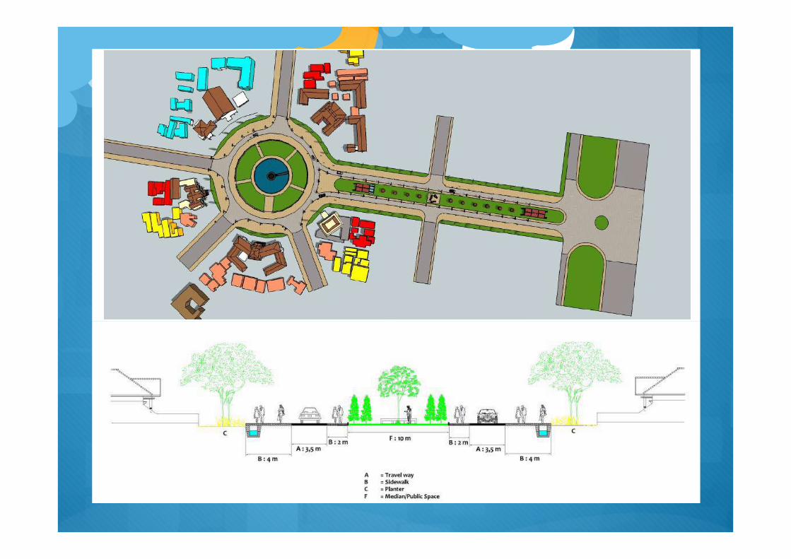
� There is a difference in color between pedestrian and travel way. Ornament � There is added planter on the right side of the street.
� On-street parking is eliminated. Car/vehicle can stop within a specified period.. Jl. Kartanegara Travel way � Limiting the width of travel way only for 4-5 meters.
� The use of paving materials as its pavement. There is no asphalt. � There is a difference in color between pedestrian and travel way. � There is no difference in 'high levels' between pedestrian and travel way.
Pedestrian � There is no difference in 'high levels' between pedestrian and travel way.
� Widening the pedestrian way, the widest possible use of the remaining existing travel way narrowed. � There is a difference in color between pedestrian and travel way.
Ornament � Limiting the width of travel way only for 4 meters.
� Changes in the function of the green lane / boulevard into public space oriented to the park, so it does not eliminate the essence of a green lane.
� There is added 'public seating' in the area of public space. � There is added pots of flowers on pedestrian. � There is added street lights on both sides of public space.
Here is the design of the cross-section and longitudinal section of the concept of BRO in Tugu sites (Fig.
3). This reasearch try to propose two design for Tugu sites. First design can be seen in Fig. 3 and Fig. 5. Secondly design can be seen in Fig. 6.
Fig. 3. Research Design
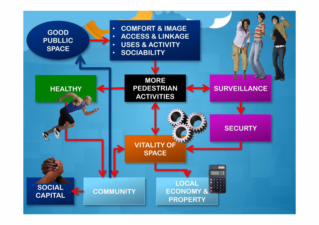
GOOD PUBLLIC
SPACE
MORE PEDESTRIAN ACTIVITIES
• COMFORT & IMAGE • ACCESS & LINKAGE • USES & ACTIVITY • SOCIABILITY
SURVEILLANCE
VITALITY OF SPACE
LOCAL ECONOMY & PROPERTY
COMMUNITY
SECURTY
HEALTHY
SOCIAL CAPITAL
