joint iho/imo/wmo manual on maritime safety information (msi) · pdf filemanual on maritime...
TRANSCRIPT

INTERNATIONAL HYDROGRAPHIC ORGANIZATION
JOINT IHO/IMO/WMO
MANUAL ON MARITIME SAFETY INFORMATION (MSI)
Special Publication No. 53
(July 2009 Edition)
Published by the International Hydrographic Bureau
MONACO
S-53


INTERNATIONAL HYDROGRAPHIC ORGANIZATION
JOINT IHO/IMO/WMO
MANUAL ON MARITIME SAFETY INFORMATION (MSI)
Special Publication No. 53
(July 2009 Edition)
Published by the
International Hydrographic Bureau
4, Quai Antoine 1er B.P. 445 – MC 98011 MONACO Cedex
Principauté de Monaco
Telephone : +377 93 10 81 00
Telefax : +377 93 10 81 40
E-mail : [email protected]
Web : http://www.iho.int


i
PREFACE
SOLAS regulation IV/12.2 states that “Every ship, while at sea, shall maintain a radio watch for
broadcasts of maritime safety information on the appropriate frequency or frequencies on which
such information is broadcast for the area in which the ship is navigating”.
At the request of the Sub-Committee on Radiocommunications, the International Hydrographic
Organization (IHO) and the World Meteorological Organization (WMO), a joint document on
the drafting of maritime safety information broadcasts was produced (the Joint IMO/IHO/WMO
Manual on Maritime Safety Information). The document was circulated to IHO Member States
under IHB CL 10/1994 and as COMSAR/Circ.4 by the Sub-Committee on
Radiocommunications and Search and Rescue (COMSAR) after its first session in February
1996, which action was endorsed by the Maritime Safety Committee at its sixty-sixth session in
May/June 1996.
The publication contained sections from IMO resolution A.706(17), “World-Wide Navigational
Warning Service”, as amended, and relevant sections of the WMO Publication “Manual on
Marine Meteorological Services”.
At its seventh meeting in September 2005, the IHO‟s Commission on the Promulgation of Radio
Navigational Warnings (CPRNW1) established a Working Group to review all World-Wide
Navigational Warning Service (WWNWS) documentation. The Working Group included
representation from the WMO and prepared at first, revisions to IMO as amended
resolutions A.705(17), “Promulgation of Maritime Safety Information” and A.706(17),
“World-Wide Navigational Warning Service”. The proposed revisions of the resolutions were
circulated to IHO Member States under IHB CL 104/2007, endorsed by COMSAR at its
twelfth session in April 2008 and subsequently approved by the Maritime Safety Committee at
its eighty-fifth session in November/December 2008.
The IHO CPRNW1 Working Group then prepared the revised Joint IMO/IHO/WMO Manual on
Maritime Safety Information incorporating the revised information from resolutions A.705(17),
as amended and A.706(17), as amended. The revised text of the Joint IMO/IHO/WMO Manual
on Maritime Safety Information was circulated to IHO Member States under cover of
IHB CL 70/2008, endorsed by COMSAR at its thirteenth session in January 2009 and
subsequently approved by the Maritime Safety Committee at its eighty-sixth session in
May/June 2009.
Although this is an IHO publication, it is intended that it will be amended so as to remain aligned
with the Joint IMO/IHO/WMO Manual on Maritime Safety Information published by IMO.
1 The Commission for the Promulgation of Radio Navigational Warnings (CPRNW) was renamed the World-Wide
Navigational Warning Service Sub-Committee (WWNWS) with effect from 1 July 2009.

ii
iii
CONTENTS
SECTION PAGE
1. GENERAL INFORMATION ................................................................................................
1
2. PROMULGATION OF MARITIME SAFETY INFORMATION ...................................
2.1 Introduction
2.2 Definitions
2.2.2 Delimitation of NAVAREAS
2.3 Broadcast methods
2.4 Scheduling
2.5 Shipboard equipment
2.6 Provision of information
2.7 Coordination procedures
2
2
3
6
7
7
8
8
9
3. COORDINATOR RESOURCES AND RESPONSIBILITIES ..........................................
3.1 NAVAREA coordinator resources
3.2 NAVAREA coordinator responsibilities
3.3 Sub-Area coordinator resources
3.4 Sub-Area coordinator responsibilities
3.5 National coordinator resources
3.6 National coordinator responsibilities
10
10
10
11
12
13
13
4. NAVIGATIONAL WARNINGS FOR THE WWNWS ......................................................
4.1 General
4.2 NAVAREA warnings
4.3 Sub-Area warnings
4.4 Coastal warnings
4.5 Local warnings
15
15
16
17
17
17
5. THE STRUCTURE OF NAVIGATIONAL WARNINGS .................................................
5.1 Numbering
5.2 Language
5.3 “No warnings” message
5.4 Standard elements of messages
5.5 Message Elements Table
18
18
18
18
18
19
6. MESSAGE FORMAT OF NAVIGATIONAL WARNING .........................................
Part 1 – PREAMBLE
Standard Message Element Reference 1 – MESSAGE SERIES IDENTIFIER
Standard Message Element Reference 2 – GENERAL AREA
Standard Message Element Reference 3 – LOCALITY
Standard Message Element Reference 4 – CHART NUMBER
Part 2 – WARNING
Standard Message Element Reference 5 – KEY SUBJECT
Standard Message Element Reference 6 – GEOGRAPHICAL POSITION
Standard Message Element Reference 7 – AMPLIFYING REMARKS
Part 3 – POSTSCRIPT
Standard Message Element Reference 8 – CANCELLATION DETAILS
20
20
20
20
21
21
22
22
22
22
23
23

iv
7. GUIDANCE AND EXAMPLES FOR NAVIGATIONAL WARNINGS BY TYPE OF
HAZARD
1. Casualties to lights, fog signals, buoys and other aids to navigation affecting main
shipping lanes;
2. The presence of dangerous wrecks in or near main shipping lanes and, if relevant,
their marking;
3. Establishment of major new aids to navigation or significant changes to existing
ones when such establishment or change, might be misleading to shipping;
4. The presence of large unwieldy tows in congested waters;
5. Drifting hazards (including derelict vessels, ice, mines, containers, other large
items, etc.);
6. Areas where search and rescue (SAR) and anti-pollution operations are being
carried out (for avoidance of such areas);
7. The presence of newly discovered rocks, shoals, reefs and wrecks likely to
constitute a danger to shipping, and, if relevant, their marking;
8. Unexpected alteration or suspension of established routes;
9. Cable or pipe-laying activities, the towing of large submerged objects for research
or exploration purposes, the employment of manned or unmanned submersibles, or
other underwater operations constituting potential dangers in or near shipping lanes;
10. The establishment of research or scientific instruments in or near shipping lanes;
11. The establishment of offshore structures in or near shipping lanes;
12. Significant malfunctioning of radio-navigation services and shore-based maritime
safety information radio or satellite services;
13. Information concerning special operations which might affect the safety of shipping,
sometimes over wide areas, e.g., naval exercises, missile firings, space missions,
nuclear tests, ordnance dumping zones, etc. It is important that where the degree of
hazard is known, this information is included in the relevant warning. Whenever
possible, such warnings should be originated not less than five days in advance of
the scheduled event and reference may be made to relevant national publications in
the warning;
14. Acts of piracy and armed robbery against ships;
15. Tsunamis and other natural phenomena, such as abnormal changes to sea level;
16. World Health Organization (WHO) health advisory information;
17. Security-related requirements
Bulletins ..........................................................................................................................................
Miscellaneous .................................................................................................................................
24
24
30
32
34
36
38
39
41
43
45
47
49
51
53
55
57
58
59
60
8. METEOROLOGICAL WARNINGS AND FORECASTS ............................................
8.1 Provision of warnings and weather and sea bulletins (GMDSS application)
8.2 Procedures
8.3 Warnings
8.4 Synopses
8.5 Forecasts
8.6 Common abbreviations for International NAVTEX Service
8.7 Delimitation of METAREAS
62
62
63
65
66
67
68
69
9. SEARCH AND RESCUE NOTIFICATION ................................................................. 70
10. PROCEDURE FOR AMENDING THE JOINT IMO/IHO/WMO MANUAL ON
MSI
70
1
1 – GENERAL INFORMATION
This manual provides a practical guide for anyone who is concerned with drafting navigational
warnings or with the issuance of meteorological forecasts and warnings under the Global
Maritime Distress and Safety System (GMDSS). Maritime Safety Information (MSI) is
promulgated in accordance with the requirements of IMO resolution A.705(17), as amended.
Navigational warnings are issued under the auspices of the IMO/International Hydrographic
Organization (IHO) World-Wide Navigational Warning Service (WWNWS) in accordance with
the requirements of IMO resolution A.706(17), as amended. Meteorological forecasts and
warnings are issued under the patronage of the World Meteorological Organization (WMO).
In order to achieve the necessary impact on the mariner it is essential to present timely and
relevant information in a consistent format that is clear, unambiguous and brief. Within this
manual, it is particularly intended to provide the best form of words for use in all types of
navigational warnings and meteorological forecasts and warnings that are required to be
broadcast in the English language2. Note has been taken of the IMO Standard Marine
Communication Phrases (resolution A.918(22)), where appropriate.
This manual cannot provide specimen texts for every type of event which may occur. However,
the principles illustrated herein may be applied in general to drafting messages for every kind of
navigational warning and covering all types of hazards and for the issuance of meteorological
forecasts and warnings.
Resolution A.706(17), as amended on the World-Wide Navigational Warning Service
(MSC.1/Circ.1288) at section 5.3.1, requires that “All NAVAREA, Sub-Area and coastal
warnings shall be broadcast only in English in the International NAVTEX and SafetyNET
services”. Where this manual has been produced in languages other than English then the
message examples given in section 7 are also provided in the English language in an additional
annex.
2 See WMO Publication Manual on Marine Meteorological Services (WMO No 558).

2
2 – PROMULGATION OF MARITIME SAFETY INFORMATION
2.1 Introduction
2.1.1 The maritime safety information service of the GMDSS is the internationally and
nationally coordinated network of broadcasts containing information which is necessary for safe
navigation, received in ships by equipment which automatically monitors the appropriate
transmissions, displays information which is relevant to the ship and provides a print capability.
This concept is illustrated in Figure 1.
Figure 1 The maritime safety information service of the
Global Maritime Distress and Safety System
2.1.2 Maritime safety information is of vital concern to all ships. It is therefore essential that
common standards are applied to the collection, editing and dissemination of this information.
Only by doing so will the mariner be assured of receiving the information he needs, in a form
which he understands, at the earliest possible time.
2.1.3 The purpose of IMO resolution A.705(17), as amended “Promulgation of Maritime Safety
Information” is to set out the organization, standards and methods which should be used for the
promulgation and reception of maritime safety information.

3
2.2 Definitions
2.2.1 For the purposes of this manual, the following definitions apply:
.1 Coast Earth Station (CES) means a fixed terrestrial radio facility acting as a
gateway between terrestrial networks and the Inmarsat satellites in the maritime
mobile-satellite service. This may also be referred to as a Land Earth Station
(LES).
.2 Coastal warning means a navigational warning promulgated as part of a
numbered series by a National coordinator. Broadcast shall be made by the
International NAVTEX service to defined NAVTEX service areas and/or by the
International SafetyNET service to coastal warning areas. (In addition,
Administrations may issue coastal warnings by other means.)
.3 Coastal warning area means a unique and precisely defined sea area within a
NAVAREA/METAREA or Sub-Area established by a coastal State for the
purpose of coordinating the broadcast of coastal maritime safety information
through the SafetyNET service.
.4 HF NBDP means High Frequency narrow-band direct-printing, using radio
telegraphy as defined in Recommendation ITU-R M.688.
.5 In-force bulletin means a list of serial numbers of those NAVAREA, Sub-Area or
coastal warnings in force issued and broadcast by the NAVAREA coordinator,
Sub-Area coordinator or National coordinator during at least the previous six
weeks.
.6 International NAVTEX service means the coordinated broadcast and automatic
reception on 518 kHz of maritime safety information by means of narrow-band
direct-printing telegraphy using the English language3.
.7 International SafetyNET service means the coordinated broadcasting and
automated reception of maritime safety information via the Inmarsat Enhanced
Group Call (EGC) system, using the English language, in accordance with the
provisions of the International Convention for the Safety of Life at Sea, 1974, as
amended.
.8 Local warning means a navigational warning which covers inshore waters, often
within the limits of jurisdiction of a harbour or port authority.
.9 Main Shipping Lanes means those routes used by international shipping.
.10 Maritime safety information (MSI)4 means navigational and meteorological
warnings, meteorological forecasts and other urgent safety-related messages
broadcast to ships.
3 As set out in the IMO NAVTEX Manual.
4 As defined in regulation IV/2 of the 1974 SOLAS Convention, as amended.
4
.11 Maritime safety information service means the internationally and nationally
coordinated network of broadcasts containing information which is necessary for
safe navigation.
.12 METAREA means a geographical sea area5 established for the purpose of
coordinating the broadcast of marine meteorological information. The term
METAREA followed by a roman numeral may be used to identify a particular sea
area. The delimitation of such areas is not related to and shall not prejudice the
delimitation of any boundaries between States.
.13 Meteorological information means the marine meteorological warning and
forecast information in accordance with the provisions of the International
Convention for the Safety of Life at Sea, 1974, as amended.
.14 National coordinator means the national authority charged with collating and
issuing coastal warnings within a national area of responsibility.
.15 National NAVTEX service means the broadcast and automatic reception of
maritime safety information by means of narrow-band direct-printing telegraphy
using frequencies other than 518 kHz and languages as decided by the
Administration concerned.
.16 National SafetyNET service means the broadcasting and automated reception of
maritime safety information via the Inmarsat EGC system, using languages as
decided by the Administration concerned.
.17 NAVAREA means a geographical sea area5 established for the purpose of
coordinating the broadcast of navigational warnings. The term NAVAREA
followed by a roman numeral may be used to identify a particular sea area. The
delimitation of such areas is not related to and shall not prejudice the delimitation
of any boundaries between States.
.18 NAVAREA coordinator means the authority charged with coordinating, collating
and issuing NAVAREA warnings for a designated NAVAREA.
.19 NAVAREA warning means a navigational warning or in-force bulletin
promulgated as part of a numbered series by a NAVAREA coordinator.
.20 Navigational warning means a message containing urgent information relevant to
safe navigation broadcast to ships in accordance with the provisions of the
International Convention for the Safety of Life at Sea, 1974, as amended.
.21 NAVTEX means the system for the broadcast and automatic reception of maritime
safety information by means of narrow-band direct-printing telegraphy.
.22 NAVTEX service area means a unique and precisely defined sea area for which
maritime safety information is provided from a particular NAVTEX transmitter.
5 Which may include inland seas, lakes and waterways navigable by sea-going ships.
5
.23 NAVTEX coordinator means the authority charged with operating and managing
one or more NAVTEX stations broadcasting maritime safety information as part
of the International NAVTEX service.
.24 Other urgent safety-related information means maritime safety information
broadcast to ships that is not defined as a navigational warning, meteorological
information or SAR information. This may include, but is not limited to,
significant malfunctions or changes to maritime communications systems, and
new or amended mandatory ship reporting systems or maritime regulations
affecting ships at sea.
.25 SafetyNET means the international service for the broadcasting and automatic
reception of maritime safety information through the Inmarsat EGC system.
SafetyNET receiving capability is part of the mandatory equipment which is
required to be carried by certain ships in accordance with the provisions of the
International Convention for the Safety of Life at Sea, 1974, as amended.
.26 SAR information means distress alert relays and other urgent search and rescue
information broadcast to ships.
.27 Sea Area A1 means an area within the radiotelephone coverage of at least one
VHF coast station in which continuous DSC6 alerting is available, as may be
defined by a Contracting Government.
.28 Sea Area A2 means an area, excluding sea area A1, within the radiotelephone
coverage of at least one MF coast station in which continuous DSC alerting is
available, as may be defined by a Contracting Government.
.29 Sea Area A3 means an area, excluding sea areas A1 and A2, within the coverage
of an Inmarsat geostationary satellite in which continuous alerting is available.
.30 Sea Area A4 means an area outside sea areas A1, A2 and A3.
.31 Sub-Area means a sub-division of a NAVAREA/METAREA in which a number
of countries have established a coordinated system for the promulgation of
maritime safety information. The delimitation of such areas is not related to and
shall not prejudice the delimitation of any boundaries between States.
.32 Sub-Area coordinator means the authority charged with coordinating, collating
and issuing Sub-Area warnings for a designated Sub-Area.
.33 Sub-Area warning means a navigational warning promulgated as part of a
numbered series by a Sub-Area coordinator. Broadcast shall be made by the
International NAVTEX service to defined NAVTEX service areas or by the
International SafetyNET service (through the appropriate NAVAREA
coordinator.)
6 Digital selective calling (DSC) means a technique using digital codes which enables a radio station to establish
contact with and transfer information to another station or group of stations and complying with the relevant
recommendations of the International Radio Consultative Committee ((CCIR) – “Radiocommunications Bureau
of the International Telecommunication Union (ITU)” from 1 March 1993).
6
.34 User defined area means a temporary geographic area, either circular or
rectangular, to which maritime safety information is addressed.
.35 UTC means Coordinated Universal Time which is equivalent to GMT (or ZULU)
as the international time standard.
.36 World-Wide Navigational Warning Service (WWNWS)7 means the internationally
and nationally coordinated service for the promulgation of navigational warnings.
.37 In the operating procedures coordination means that the allocation of the time for
data broadcast is centralized, the format and criteria of data transmissions are
compliant as described in the Joint IMO/IHO/WMO Manual on Maritime Safety
Information and that all services are managed as set out in
IMO resolutions A.705(17), as amended and A.(706)17, as amended.
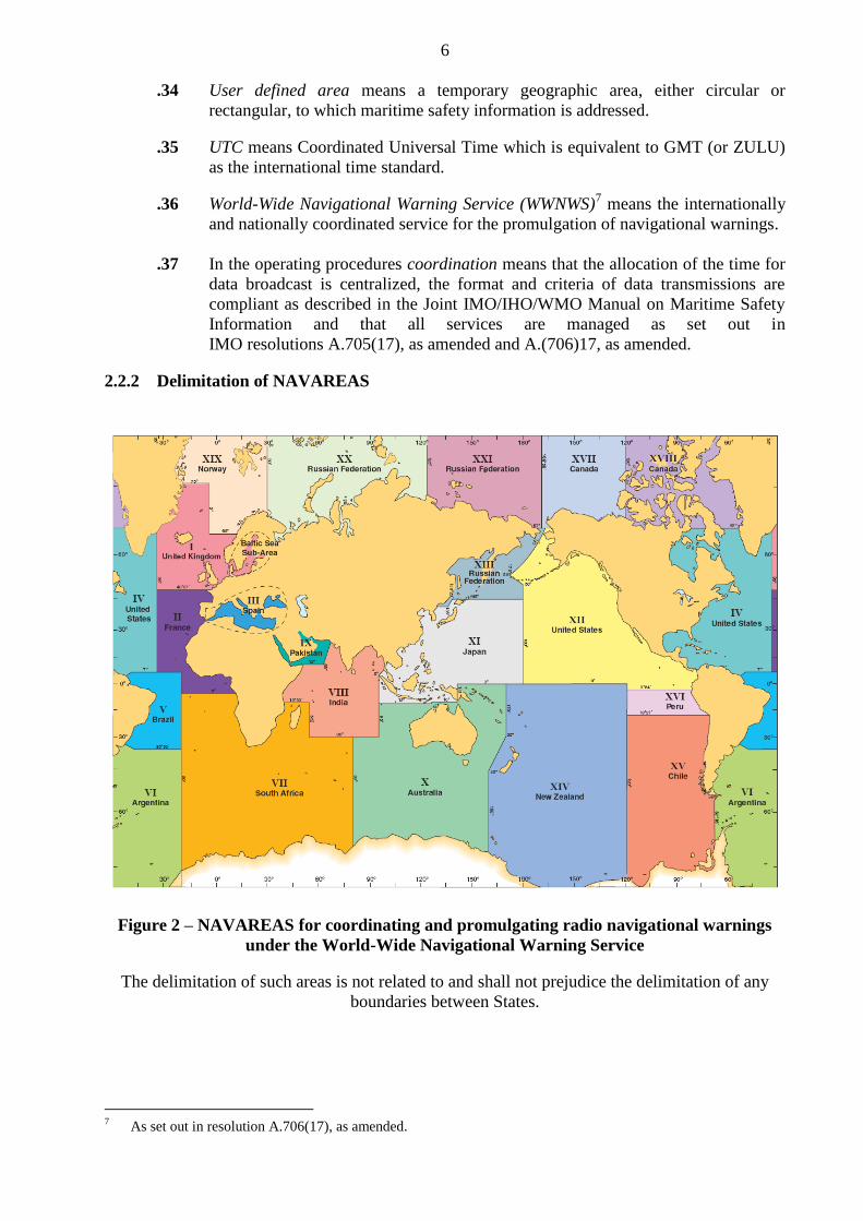
2.2.2 Delimitation of NAVAREAS
Figure 2 – NAVAREAS for coordinating and promulgating radio navigational warnings
under the World-Wide Navigational Warning Service
The delimitation of such areas is not related to and shall not prejudice the delimitation of any
boundaries between States.
7 As set out in resolution A.706(17), as amended.

7
2.3 Broadcast methods
2.3.1 Two principal methods are used for broadcasting maritime safety information in
accordance with the provisions of the International Convention for the Safety of Life at
Sea, 1974, as amended, in the areas covered by these methods, as follows:
.1 NAVTEX: broadcasts to coastal waters; and
.2 SafetyNET: broadcasts which cover all the waters of the globe except for
Sea Area A4, as defined by IMO resolution A.801(19), Annex 3, as amended.
2.3.2 Information should be provided for unique and precisely defined sea areas, each being
served only by the most appropriate of the above methods. Although there will be some
duplication to allow a vessel to change from one method to another, the majority of messages
will be broadcast either on NAVTEX or SafetyNET.
2.3.3 NAVTEX broadcasts shall be made in accordance with the standards and procedures set
out in the NAVTEX Manual.
2.3.4 SafetyNET broadcasts shall be made in accordance with the standards and procedures set
out in the International SafetyNET Manual.
2.3.5 HF NBDP may be used to promulgate maritime safety information in areas outside
Inmarsat or NAVTEX coverage (SOLAS regulation IV/7.1.5).
2.3.6 In addition, Administrations may also provide maritime safety information by other
means.
2.3.7 In the event of failure of normal transmission facilities, an alternative means of
transmission should be utilized. A NAVAREA Warning and a coastal Warning, if possible,
should be issued detailing the failure, its duration and, if known, the alternative route for the
dissemination of MSI.
2.4 Scheduling
2.4.1 Automated methods (NAVTEX /SafetyNET)
2.4.1.1 Navigational warnings shall be broadcast as soon as possible or as dictated by the nature
and timing of the event. Normally, the initial broadcast should be made as follows:
.1 for NAVTEX, at the next scheduled broadcast, unless circumstances indicate the
use of procedures for VITAL or IMPORTANT warnings; and
.2 for SafetyNET, within 30 minutes of receipt of original information, or at the
next scheduled broadcast.
2.4.1.2 Navigational warnings shall be repeated in scheduled broadcasts in accordance with the
guidelines promulgated in the NAVTEX Manual and International SafetyNET Manual as
appropriate.

8
2.4.1.3 At least two scheduled daily broadcast times are necessary to provide adequate
promulgation of NAVAREA warnings. When NAVAREAs extend across more than six time
zones, more than two broadcasts should be considered to ensure that warnings can be received.
When using SafetyNET in lieu of NAVTEX for coastal warnings, Administrations may need to
consider an increase in the number of scheduled daily broadcasts compared with the requirement
for NAVAREA warnings.
2.4.2 Schedule changes
2.4.2.1 Broadcast times for NAVTEX are defined by the B1 character of the station, allocated by
the coordinating Panel on NAVTEX Services of the Sub-Committee on Radiocommunications
and Search and Rescue.
2.4.2.2 Times of scheduled broadcasts under the International SafetyNET service are
coordinated through the International SafetyNET coordinating Panel.
2.5 Shipboard equipment
2.5.1 Ships are required to be capable of receiving maritime safety information broadcasts for
the area in which they operate in accordance with the provisions of the International Convention
for the Safety of Life at Sea, 1974, as amended.
2.5.2 The NAVTEX receiver should operate in accordance with the technical specifications set
out in Recommendation ITU-R M.540-2, as amended, and should meet the performance
standards adopted by IMO resolution MSC.148(77), as amended.
2.5.3 The SafetyNET receiver should conform to the Maritime Design and Installation
Guidelines (DIGs) published by Inmarsat, and should meet the performance standards adopted by
IMO resolution A.664(16).
2.5.4 In Sea Area A4, outside of the coverage of NAVTEX, where MSI is received using
HF NBDP, the HF NBDP receiver should operate in accordance with the technical specifications
set out in Recommendation ITU-R M.688, as amended, and should meet the performance
standards adopted by IMO resolution A.700(17), as amended.
2.6 Provision of information
2.6.1 Navigational warnings shall be provided in accordance with the standards, organization
and procedures of the WWNWS under the functional guidelines of the IHO through its
Commission on Promulgation of Radio Navigational Warnings. Details of NAVAREA
coordinators are maintained on the IHO Web site www.iho.org>committees> and are also
published by an IMO COMSAR circular.
2.6.2 Meteorological information shall be provided in accordance with the WMO technical
regulations and recommendations, monitored and reviewed by the Expert Team on Maritime
Safety Services of the Joint WMO/IOC8 Commission for Oceanography and Marine
Meteorology (JCOMM).
8 IOC is the Intergovernmental Oceanographic Commission of UNESCO.

9
2.6.3 SAR information shall be provided by the various authorities responsible for coordinating
maritime search and rescue operations in accordance with the standards and procedures
established by the IMO.
2.6.4 Other urgent safety-related information shall be provided by the relevant national or
international authority responsible for managing the system or scheme.
2.6.5 Relevant national or international authorities shall take into account the need for
contingency planning.
2.7 Coordination procedures
2.7.1 In order to make the best use of automated reception facilities and to ensure that the
mariner receives at least the minimum information necessary for safe navigation, careful
coordination is required.
2.7.2 In general, this requirement for coordination will be met by the standard operational
procedures of IMO, IHO, WMO, International Telecommunication Union (ITU) and
International Mobile Satellite Organization (IMSO). Cases of difficulty should be referred, in the
first instance, to the most appropriate parent body.
2.7.3 Administrations broadcasting maritime safety information should provide details of
services to the IMO, which will maintain and publish this as part of the GMDSS Master Plan.
2.7.4 The coordination of changes to operational NAVTEX services and of the establishment of
new stations is undertaken by the Coordinating Panel on NAVTEX Services of the
Sub-Committee on Radiocommunications and Search and Rescue on behalf of the Maritime
Safety Committee.
2.7.5 The coordination of changes to operational SafetyNET services and of the authorization
and registration of information providers is undertaken by the International SafetyNET
Coordinating Panel of the Sub-Committee on Radiocommunications and Search and Rescue on
behalf of the Maritime Safety Committee.
2.7.6 Administrations should design their broadcasts to suit specific service areas9.
The designation of service areas is an important part of the coordination process since it is
intended that a ship should be able to obtain all the information relevant to a given area from a
single source. The Maritime Safety Committee approves NAVAREAs/METAREAs and service
areas for the International NAVTEX and SafetyNET service as advised by IHO and WMO.
9 Coordination of HF NBDP broadcasts in the Arctic should be undertaken by relevant MSI Service Providers.

10
3 – COORDINATOR RESOURCES AND RESPONSIBILITIES
3.1 NAVAREA coordinator resources
3.1.1 The NAVAREA coordinator must have:
.1 the expertise and information sources of a well established national hydrographic
service;
.2 effective communications, e.g., telephone, e-mail, facsimile, internet, telex, etc.,
with Sub-Area and National coordinators in the NAVAREA, with other
NAVAREA coordinators, and with other data providers; and
.3 access to broadcast systems for transmission to the navigable waters of the
NAVAREA. As a minimum, this shall include those described in paragraph 2.3.1.
Reception should normally be possible at least 300 nautical miles beyond the limit
of the NAVAREA (24 hours sailing by a fast ship).
3.2 NAVAREA coordinator responsibilities
3.2.1 The NAVAREA coordinator must:
.1 endeavour to be informed of all events that could significantly affect the safety of
navigation within the NAVAREA;
.2 assess all information immediately upon receipt in the light of expert knowledge
for relevance to navigation in the NAVAREA;
.3 select information for broadcast in accordance with the guidance given in
paragraph 4.2;
.4 draft NAVAREA warnings in accordance with the Joint IMO/IHO/WMO Manual
on Maritime Safety Information;
.5 direct and control the broadcast of NAVAREA warnings, in accordance with the
provisions of the International Convention for the Safety of Life at Sea, 1974, as
amended;
.6 forward NAVAREA warnings and relevant associated information which may
require wider promulgation directly to adjacent NAVAREA coordinators and/or
others as appropriate, using the quickest possible means;
.7 ensure that NAVAREA warnings which may remain in force for more than six
weeks are made available immediately to NAVAREA coordinators, other
authorities and mariners in general, as appropriate;
.8 ensure that information concerning all navigational warning subject areas listed in
paragraph 4.2.2 that may not require a NAVAREA warning within their own
NAVAREA is forwarded immediately to the appropriate National and
NAVAREA coordinators affected by the event;
.9 broadcast in-force bulletins not less than once per week at a regularly scheduled
time;

11
.10 promulgate the cancellation of NAVAREA warnings which are no longer valid;
.11 act as the central point of contact on matters relating to navigational warnings
within the NAVAREA;
.12 promote and oversee the use of established international standards and practices
with respect to the promulgation of navigational warnings throughout the
NAVAREA;
.13 when notified by the authority designated to act on reports of piracy and armed
robbery against ships, arrange for the broadcast of a suitable NAVAREA warning.
Additionally, keep the national or regional piracy control centre informed of
long-term broadcast action(s);
.14 when notified by the appropriate authorities, arrange for the broadcast of suitable
NAVAREA warnings to promulgate World Health Organization (WHO) health
advisory information; and tsunami-related information;
.15 monitor the broadcasts which they originate to ensure that the messages have been
correctly broadcast;
.16 maintain records of source data relating to NAVAREA warnings in accordance
with the requirement of the National Administration of the NAVAREA
coordinator;
.17 coordinate preliminary discussions between neighbouring Member States, seeking
to establish or amend NAVTEX services and with other adjacent Administrations,
prior to formal application;
.18 contribute to the development of international standards and practices through
attendance and participation in the IHO Commission on the Promulgation of
Radio Navigational Warnings (CPRNW10
) meetings, and also participate in
relevant IMO, IHO and WMO fora as appropriate, e.g., Sub-Committee on
Radiocommunications and Search and (COMSAR), Expert Team on Maritime
Safety Services (ETMSS) and other regional conferences, etc., as required; and
.19 take into account the need for contingency planning.
3.3 Sub-Area coordinator resources
3.3.1 The Sub-Area coordinator must have, or have access to:
.1 the expertise and information sources of a well established national hydrographic
service;
.2 effective communications, e.g., telephone, e-mail, facsimile, internet, telex, etc.,
with National coordinators in the Sub-Area, with the NAVAREA coordinator, and
with other data providers; and
10
The Commission for the Promulgation of Radio Navigational Warnings (CPRNW) was renamed the World-Wide
Navigational Warning Service Sub-Committee (WWNWS) with effect from 1 July 2009.
12
.3 access to broadcast systems for transmission to the entire Sub-Area.
3.4 Sub-Area coordinator responsibilities
3.4.1 The Sub-Area coordinator must:
.1 endeavour to be informed of all events that could significantly affect the safety of
navigation within the Sub-Area;
.2 assess all information immediately upon receipt in the light of expert knowledge
for relevance to navigation in the Sub-Area;
.3 select information for broadcast in accordance with the guidance given in
paragraph 4.2;
.4 draft Sub-Area warnings in accordance with the Joint IMO/IHO/WMO Manual on
Maritime Safety Information;
.5 direct and control the broadcast of Sub-Area warnings, in accordance with the
provisions of the International Convention for the Safety of Life at Sea, 1974, as
amended;
.6 forward Sub-Area warnings and relevant associated information which may
require wider promulgation directly to their own NAVAREA coordinator using
the quickest possible means;
.7 broadcast in-force bulletins not less than once per week at a regularly scheduled
time;
.8 promulgate the cancellation of Sub-Area warnings which are no longer valid;
.9 act as the central point of contact on matters relating to navigational warnings
within the Sub-Area;
.10 promote the use of established international standards and practices in the
promulgation of navigational warnings within the Sub-Area;
.11 monitor the broadcasts which they originate to ensure that the messages have been
correctly broadcast;
.12 maintain records of source data relating to Sub-Area warnings in accordance with
the requirement of the National Administration of the Sub-Area coordinator;
.13 contribute to the development of international standards and practices through
attendance and participation in the IHO CPRNW11
meetings, and also participate
in relevant IMO, IHO and WMO fora as appropriate, e.g., COMSAR, ETMSS,
and other regional conferences, etc., as required; and
.14 take into account the need for contingency planning.
11
The Commission for the Promulgation of Radio Navigational Warnings (CPRNW) was renamed the World-Wide
Navigational Warning Service Sub-Committee (WWNWS) with effect from 1 July 2009.

13
3.5 National coordinator resources
3.5.1 The National coordinator must have:
.1 established sources of information relevant to the safety of navigation within
national waters;
.2 effective communications, e.g., telephone, e-mail, facsimile, internet, telex, etc.,
with the NAVAREA/Sub-Area coordinator and adjacent National coordinators;
and
.3 access to broadcast systems for transmission to their area of national responsibility.
3.6 National coordinator responsibilities
3.6.1 The National coordinator must:
.1 endeavour to be informed of all events that could significantly affect the safety of
navigation within their area of national responsibility;
.2 assess all information immediately upon receipt in the light of expert knowledge
for relevance to navigation in their area of national responsibility;
.3 select information for broadcast in accordance with the guidance given in
paragraph 4.2;
.4 draft coastal warnings in accordance with the Joint IMO/IHO/WMO Manual on
Maritime Safety Information;
.5 direct and control the broadcast of coastal warnings, in accordance with the
provisions of the International Convention for the Safety of Life at Sea, 1974, as
amended;
.6 forward coastal warnings and relevant associated information which may require
wider promulgation directly to their NAVAREA coordinator and/or adjacent
National coordinators as appropriate, using the quickest possible means;
.7 broadcast in-force bulletins not less than once per week at a regularly scheduled time;
.8 promulgate the cancellation of coastal warnings which are no longer valid;
.9 act as the central point of contact on matters relating to navigational warnings
within their area of national responsibility;
14
.10 promote the use of established international standards and practices in the
promulgation of navigational warnings within their area of national responsibility;
.11 monitor the broadcasts which they originate to ensure that the messages have been
correctly broadcast;
.12 maintain records of source data relating to coastal warnings in accordance with the
requirement of the National Administration of the National coordinator; and
.13 take into account the need for contingency planning.

15
4 – NAVIGATIONAL WARNINGS FOR THE WORLD-WIDE
NAVIGATIONAL WARNING SERVICE
4.1 General
4.1.1 Navigational warnings are issued in response to SOLAS regulation V/4 and carry
information which may have a direct bearing on the safety of life at sea. It is the fundamental
nature of navigational warnings that they will often be based on incomplete or unconfirmed
information and mariners will need to take this into account when deciding what reliance to place
on the information contained therein.
4.1.2 In order to achieve the necessary impact on the mariner it is essential to present timely
and relevant information in a consistent format that is CLEAR, UNAMBIGUOUS and BRIEF.
This is ensured by using structured messages in standard formats, as shown in sections 6 and 7 of
this manual.
4.1.3 The resources employed by administrations and the mariner are extremely limited.
Thus only information which is vital to the safe conduct of vessels should be transmitted.
Notices to Mariners and other means exist for passing less urgent information to ships after they
have reached port. Information of a purely administrative nature should never be broadcasted on
the regular international navigational warning schedules.
4.1.4 There are four types of navigational warnings: NAVAREA warnings, Sub-Area warnings,
coastal warnings and local warnings. The WWNWS guidance and coordination are involved
with only three of them:
.1 NAVAREA warnings,
.2 Sub-Area warnings, and
.3 Coastal warnings.
4.1.5 Navigational warnings shall remain in force until cancelled by the originating
coordinator. Navigational warnings should be broadcast for as long as the information is valid;
however, if they are readily available to mariners by other official means, for example in Notices
to Mariners, then after a period of six weeks they may no longer be broadcast.
4.1.6 The minimum information in a navigational warning which a mariner requires is “hazard”
and “position”. It is usual, however, to include sufficient extra detail to allow some freedom of
action in the vicinity of the hazard. This means that the message should give enough extra data
for the mariner to be able to recognize the hazard and assess its effect upon his navigation.
4.1.7 If known, the duration of the event causing a navigational warning should be given in the
text.
4.1.8 Some of the subjects for navigational warnings listed in paragraph 4.2.2 (e.g., drifting ice,
tsunami warnings, negative tidal surges) may also be suitable for promulgation as METAREA
forecasts or warnings. In this event, appropriate coordination between the relevant NAVAREA
coordinator and METAREA Issuing Service must occur.

16
4.2 NAVAREA warnings
4.2.1. NAVAREA warnings are concerned with the information detailed below which
ocean-going mariners require for their safe navigation. This includes, in particular, new
navigational hazards and failures of important aids to navigation as well as information which
may require changes to planned navigational routes.
4.2.2 The following subjects are considered suitable for broadcast as NAVAREA warnings.
This list is not exhaustive and should be regarded only as a guideline. Furthermore, it
presupposes that sufficiently precise information about the item has not previously been
disseminated in a Notice to Mariners:
.1 casualties to lights, fog signals, buoys and other aids to navigation affecting main
shipping lanes;
.2 the presence of dangerous wrecks in or near main shipping lanes and, if relevant,
their marking;
.3 establishment of major new aids to navigation or significant changes to existing
ones when such establishment or change, might be misleading to shipping;
.4 the presence of large unwieldy tows in congested waters;
.5 drifting hazards (including derelict vessels, ice, mines, containers, other large
items, etc.);
.6 areas where search and rescue (SAR) and anti-pollution operations are being
carried out (for avoidance of such areas);
.7 the presence of newly discovered rocks, shoals, reefs and wrecks likely to
constitute a danger to shipping, and, if relevant, their marking;
.8 unexpected alteration or suspension of established routes;
.9 cable or pipe-laying activities, the towing of large submerged objects for research
or exploration purposes, the employment of manned or unmanned submersibles,
or other underwater operations constituting potential dangers in or near shipping
lanes;
.10 the establishment of research or scientific instruments in or near shipping lanes;
.11 the establishment of offshore structures in or near shipping lanes;
.12 significant malfunctioning of radio-navigation services and shore-based maritime
safety information radio or satellite services;

17
.13 information concerning special operations which might affect the safety of
shipping, sometimes over wide areas, e.g., naval exercises, missile firings, space
missions, nuclear tests, ordnance dumping zones, etc. It is important that where
the degree of hazard is known, this information is included in the relevant
warning. Whenever possible such warnings should be originated not less than
five days in advance of the scheduled event and reference may be made to
relevant national publications in the warning;
.14 acts of piracy and armed robbery against ships;
.15 tsunamis and other natural phenomena, such as abnormal changes to sea level;
.16 World Health Organization (WHO) health advisory information; and
.17 security-related requirements12
.
4.3 Sub-Area warnings
4.3.1 Sub-Area warnings broadcast information which is necessary for safe navigation within a
Sub-Area. They will normally include all subjects listed in 4.2.2 above, but will usually affect
only the Sub-Area.
4.4 Coastal warnings
4.4.1 Coastal warnings broadcast information which is necessary for safe navigation within
areas seaward of the fairway buoy or pilot station, and should not be restricted to main shipping
lanes. Where the area is served by NAVTEX, it should provide navigational warnings for the
entire NAVTEX service area. Where the area is not served by NAVTEX, it is necessary to
include all warnings relevant to the coastal waters up to 250 miles from the coast in the
International SafetyNET service broadcast.
4.4.2 Coastal warnings should include at least the subjects in 4.2.2.
4.5 Local warnings
4.5.1 Local warnings broadcast information which cover inshore waters, often within the limits
of jurisdiction of a harbour or port authority. They are broadcast by means other than NAVTEX
or SafetyNET, and supplement coastal warnings by giving detailed information within inshore
waters.
12
In accordance with the requirements of the International Ship and Port Facility Security Code only.

18
5 – THE STRUCTURE OF NAVIGATIONAL WARNINGS
5.1 Numbering
5.1.1 Navigational warnings in each series shall be consecutively numbered throughout the
calendar year, commencing with 1/YY at 0000 UTC on 01 January.
5.1.2 Navigational warnings shall be transmitted in reverse numerical order on scheduled
broadcasts.
5.2 Language
5.2.1 All NAVAREA, Sub-Area and coastal warnings shall be broadcast only in English in the
International NAVTEX and SafetyNET services in accordance with IMO resolution A.706(17),
as amended.
5.2.2 In addition to the required broadcasts in English, NAVAREA, Sub-Area and coastal
warnings may be broadcast in a national language using national NAVTEX and SafetyNET
services and/or other means.
5.2.3 Local warnings may be issued in the national language and/or in English.
5.3 “No warnings” message
5.3.1 When there are no navigational warnings to be disseminated at a scheduled broadcast
time, a brief message shall be transmitted to identify the broadcast and advise the mariner that
there is no navigational warning message traffic on hand.
5.4 Standard elements of messages
5.4.1 The minimum information which a mariner requires to avoid danger is:
HAZARD + POSITION
It is usual, however, to include amplifying remarks in order to provide sufficient extra details to
clearly identify the significance of the hazard and to assist mariners in recognizing and assessing
its effect upon their navigation. The time, date and duration of the event shall be included if
known.
5.4.2 A message can have up to three parts: Preamble, Warning, and Postscript. Sections 6
and 7 of the Manual give guidance on the correct way of phrasing each part of the warning to
achieve maximum impact with minimum broadcast time.
5.4.3 The text of a navigational warning shall contain specific message elements, identified and
ordered by the reference numbers shown in Figure 3 and expanded in Section 6. The format and
structure of a message should ensure that each message element begins on a new line.
5.4.4 The first words of the text of every warning message shall always be the message series
identifier, followed by the consecutive number; this may be preceded on a separate line by the
time of origin of the message.

19
5.5 Message Elements Table
MESSAGE ELEMENTS TABLE
Part Reference No.13
Message Elements
Preamble
1 Message series identifier
2 General area
3 Locality
4 Chart number
Warning
5 Key subject
6 Geographical position
7 Amplifying remarks
Postscript 8 Cancellations details
Figure 3 – Message Elements Table showing standard elements for each part of a message
13
Reference number is NOT to be included as part of the message text.

20
6 – MESSAGE FORMAT OF NAVIGATIONAL WARNING
Part 1 PREAMBLE
Standard Message Element Reference 1 – MESSAGE SERIES IDENTIFIER
The first words of the text of every warning message shall always be message series identifier
followed by the consecutive number (N/YY)
NAVAREA WARNING: NAVAREA III 496/09;
NAVAREA VII 42/09
SUB-AREA WARNING: BALTIC SEA NAV WARN 009/09
COASTAL WARNING: AVURNAV TOULON 1015/09;
WZ 345/09
Notes:
1) The consecutive number re-starts each calendar year at 1/YY (Leading zeros are not mandatory).
2) For coastal warnings the consecutive number is not the same as the NAVTEX Number B3B4.
Standard Message Element Reference 2 – GENERAL AREA
The general area shall be sufficient to identify which broad geographic region the message affects.
The geographical name which is selected for the general area should be one that can be found on
charts and in nautical publications.
NAVAREA WARNING: “NORTH SEA” or “MALACCA STRAIT” would be correct; “NORTH AMERICA, EAST COAST”
is too general.
SUB-AREA WARNING: GULF OF FINLAND
COASTAL WARNING: BAY OF BISCAY;
CANTABRICO
Notes: 1) If appropriate the established meteorological forecast areas as defined in WMO publication No. 9 Volume D and also
published in various nautical publications may be used.
2) For a NAVAREA-wide event, e.g., failure of satellite or terrestrial positioning systems, a navaid identification
acronym “GPS”, “LORAN”, etc., shall by used instead of a general area.

21
Standard Message Element Reference 3 – LOCALITY
The locality shall be stated in terms which allow the mariner to identify warnings which affect his
passage without having to plot them. Locality will only need to be stated when it is considered
necessary to refine the general area. The geographical name which is selected as locality should be
one that can be found on charts and in nautical publications.
NAVAREA WARNING: NORTHERN GRAND BANKS;
PINANG APPROACH
SUB-AREA WARNING: STORA MIDDELGRUND
COASTAL WARNING: BARRA DE PARANAGUA – CANAL DA GALHETA
Note: 1) If appropriate the established meteorological forecast areas as defined in WMO publication No. 9 Volume D and also
published in various nautical publications may be used.
Standard Message Element Reference 4 – CHART NUMBER
For charted features, reference shall be made to a national chart (not necessarily the largest scale)
identified by the State abbreviation and chart number. Reference shall also be made to an
international chart number if one exists;
NAVAREA WARNING: Chart INDIA 32 (INT 754)
Notes:
1) Warnings may refer to an Electronic Navigational Chart (ENC). In such cases, ENC cell numbers may be quoted,
e.g., ENC: US3AK7RM
2) Chart or ENC cell numbers are not mandatory for coastal warnings which are only broadcast in the vicinity of the
hazard.

22
Part 2 WARNING
Standard Message Element Reference 5 – KEY SUBJECT
Key subjects referenced in paragraph 4.2.2 are considered suitable for broadcast as NAVAREA,
SUB-AREA, or COASTAL Warnings. See examples in Section 7.
Standard Message Element Reference 6 – GEOGRAPHICAL POSITION
Geographical positions shall always be given in Degrees and Minutes or in Degrees, Minutes and
decimal minutes in the form:
Latitude: DD-MMN or DD-MMS
Longitude: DDD-MME or DDD-MMW
or
Latitude: DD-MM.mmN or DD-MM.mmS
Longitude: DDD-MM.mmE or DDD-MM.mmW
e.g., 07-08N 039-17W
32-18.65S 165-02.81E
Note that leading zeros shall always be included. Three digits are used for reporting degrees of
longitude.
For warnings concerning the presence of dangerous wrecks or newly discovered rocks, shoals and
reefs (ref: 4.2.2.2 and 4.2.2.7), the word LOCATED should only be used when the position of the
hazard has been confirmed by a hydrographic survey. In all other cases the word REPORTED should
be used.
Positions shall only be quoted to the accuracy required. In many cases this will be less than the
known accuracy. For example, it will often be sufficient to quote the position to the nearest whole
minute of latitude and longitude when indicating the location of a charted feature. The best accuracy
available (to a maximum of 0.01 minutes) shall be used when broadcasting the position of new
hazards. The same level of accuracy shall always be quoted for both latitude and longitude.
When defining the limits of a polygon, positions should be listed in a clockwise direction starting
from the North West corner.
Circular areas should be defined by a radius in nautical miles from a single point.
The use of the word “POSITION” or “POS” is not necessary.
Standard Message Element Reference 7 – AMPLIFYING REMARKS
Amplifying remarks may be used to provide sufficient extra details to clearly identify the significance
of the hazard and to assist mariners in RECOGNIZING and ASSESSING its effect upon their
navigation.
Distances shall be quoted in Nautical Miles and decimals.
The time, date and duration of the event shall be included if known. The time standard for
Navigational Warnings shall always be UTC (ref: 2.2.1.34)
The accepted format for a Date Time Group (DTG) in the text of a message is as follows:
DDHHMM UTC MoMoMo YY; e.g., 231642 UTC JUN 09

23
Part 3 POSTCRIPT
Standard Message Element Reference 8 – CANCELLATION DETAILS
Cancellation details shall be provided in a message that includes a definitive time frame; the
cancellation time shall be one hour after the event completes or one day later if the time is not
accurately known.
A reason for the cancellation should only be included if it is of benefit to the mariner, and can be
stated concisely.
Cancellations messages may be “stand alone” and only concern the cancellation of a previous
message, as in examples A and B below.
When cancellation details relating to the subject of the message are included, it is recommended that
paragraph numbers are used in order to clearly distinguish between the subject of the message and the
cancellation details, as in example C below.
The word “MESSAGE” can be abbreviated to MSG.
Examples Comments
A.
CANCEL NAVAREA IV 123/09 AND THIS
MSG.
B.
CANCEL ESTONIAN NAV WARN 87/08.
ESTONIAN NOTICES TO MARINERS 520/09
REFERS.
C.
1. MESSAGE TEXT – EVENT OF KNOWN
DURATION.
2. CANCEL THIS MSG DDHHMM UTC
MoMoMo YY.
Choose a time for self-cancelling messages
(example C) one hour after the event completes
or one day later if time is not accurately known.

24
7 – GUIDANCE AND EXAMPLES FOR NAVIGATIONAL WARNINGS BY
TYPE OF HAZARD (AS LISTED IN 4.2.2) NOTE: All NAVAREA, Sub-Area and coastal warnings shall be broadcast only in English in the
International NAVTEX and SafetyNET services in accordance with IMO resolution A.706(17),
as amended. 1. Casualties to lights, fog signals, buoys and other aids to navigation affecting main
shipping lanes The text of a navigational warning in this category shall contain message elements 1, 2, 3, 4, 5, 6, 7 identified and ordered, as in Message Elements Table Figure 3.
25
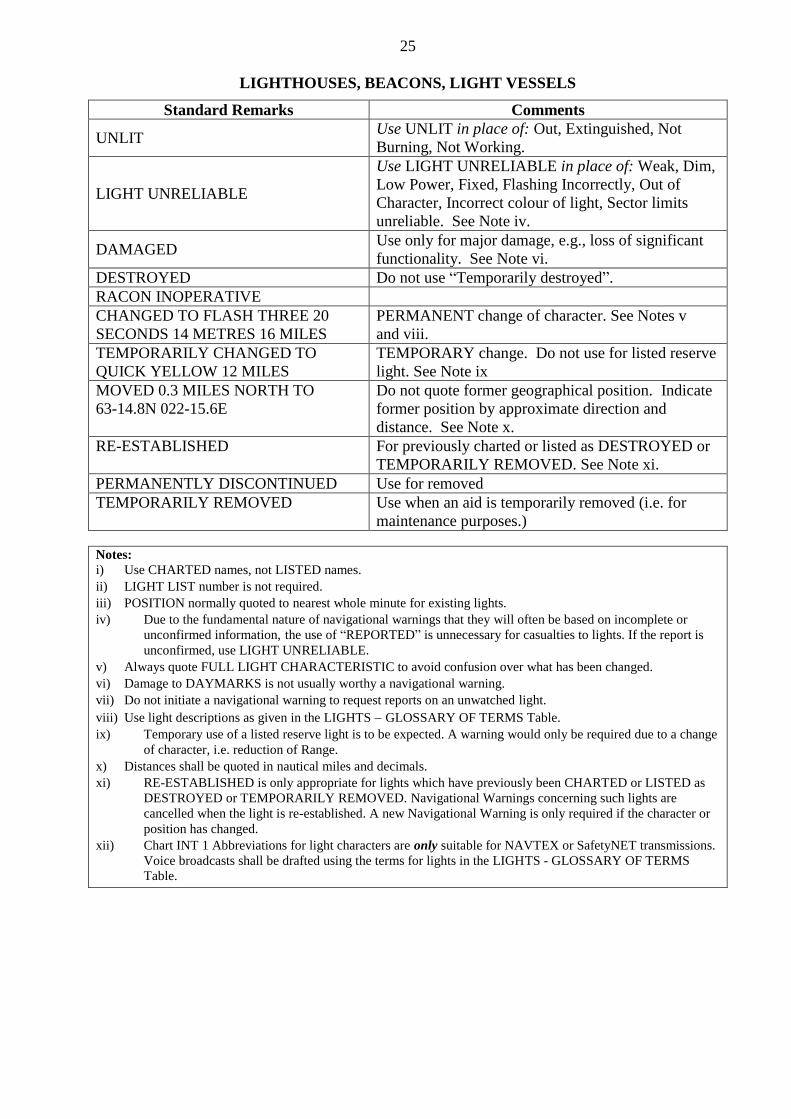
LIGHTHOUSES, BEACONS, LIGHT VESSELS
Standard Remarks Comments
UNLIT Use UNLIT in place of: Out, Extinguished, Not
Burning, Not Working.
LIGHT UNRELIABLE
Use LIGHT UNRELIABLE in place of: Weak, Dim,
Low Power, Fixed, Flashing Incorrectly, Out of
Character, Incorrect colour of light, Sector limits
unreliable. See Note iv.
DAMAGED Use only for major damage, e.g., loss of significant
functionality. See Note vi.
DESTROYED Do not use “Temporarily destroyed”.
RACON INOPERATIVE
CHANGED TO FLASH THREE 20
SECONDS 14 METRES 16 MILES
PERMANENT change of character. See Notes v
and viii.
TEMPORARILY CHANGED TO
QUICK YELLOW 12 MILES
TEMPORARY change. Do not use for listed reserve
light. See Note ix
MOVED 0.3 MILES NORTH TO
63-14.8N 022-15.6E
Do not quote former geographical position. Indicate
former position by approximate direction and
distance. See Note x.
RE-ESTABLISHED For previously charted or listed as DESTROYED or
TEMPORARILY REMOVED. See Note xi.
PERMANENTLY DISCONTINUED Use for removed
TEMPORARILY REMOVED Use when an aid is temporarily removed (i.e. for
maintenance purposes.)
Notes:
i) Use CHARTED names, not LISTED names.
ii) LIGHT LIST number is not required.
iii) POSITION normally quoted to nearest whole minute for existing lights.
iv) Due to the fundamental nature of navigational warnings that they will often be based on incomplete or
unconfirmed information, the use of “REPORTED” is unnecessary for casualties to lights. If the report is
unconfirmed, use LIGHT UNRELIABLE.
v) Always quote FULL LIGHT CHARACTERISTIC to avoid confusion over what has been changed.
vi) Damage to DAYMARKS is not usually worthy a navigational warning.
vii) Do not initiate a navigational warning to request reports on an unwatched light.
viii) Use light descriptions as given in the LIGHTS GLOSSARY OF TERMS Table.
ix) Temporary use of a listed reserve light is to be expected. A warning would only be required due to a change
of character, i.e. reduction of Range.
x) Distances shall be quoted in nautical miles and decimals.
xi) RE-ESTABLISHED is only appropriate for lights which have previously been CHARTED or LISTED as
DESTROYED or TEMPORARILY REMOVED. Navigational Warnings concerning such lights are
cancelled when the light is re-established. A new Navigational Warning is only required if the character or
position has changed. xii) Chart INT 1 Abbreviations for light characters are only suitable for NAVTEX or SafetyNET transmissions.
Voice broadcasts shall be drafted using the terms for lights in the LIGHTS - GLOSSARY OF TERMS
Table.

26
LIGHTS GLOSSARY OF TERMS
CLASS OF LIGHT Description for TEXT
broadcasts
Description for VOICE
broadcasts
Fixed (steady light) F Fixed
Occulting (total duration of
light longer than total
duration of darkness)
Single-occulting
Group-occulting
Composite group-occulting
OC
OC(2)
OC(2+3)
Occulting
Occulting two
Occulting two plus three
Isophase (equal periods light and
dark)
ISO Iso
Flashing (total duration of
light shorter than total
duration of darkness)
Single-flashing
Long-flashing
Group-flashing
Composite group-flashing
FL
LFL
FL(3)
FL(2+1)
Flash
Long flash
Flash three
Flash two plus one
Quick (50 to 79 – usually either 50
or 60 flashes per minute)
Continuous quick
Group quick
Interrupted quick
Q
Q(3)
IQ
Quick flash
Quick flash three
Interrupted quick flash
Very quick (80 to 159 – usually
either 100 or 120 flashes per minute)
Continuous very quick
Group very quick
Interrupted very quick
VQ
VQ(3)
IVQ
Very quick flash
Very quick flash three
Interrupted very quick flash
Ultra quick (160 or more usually 240
or 300 flashes per minute)
Continuous ultra quick
Interrupted ultra quick
UQ
IUQ
Ultra quick flash
Interrupted ultra quick flash
Morse Code MO(K) Morse Kilo
Fixed and Flashing FFL Fixed and flashing
Alternating ALWR Alternating
ELEVATION in METRES or FEET, e.g., 14 METRES or 21 FEET
PERIOD in SECONDS, e.g., 15 SECONDS or 15 SEC (Not S)
RANGE in nautical miles International abbreviations RANGE for broadcast
Single range
2 ranges
3 or more ranges
e.g.
e.g.
e.g.
15M
14/12M
22–18M
15 MILES
14 AND 12 MILES
22 TO 18 MILES
(Shortest range only
will be sufficient)

27
BUOYS, LANBYS, SUPERBUOYS
Standard Remarks Comments
UNLIT Use UNLIT in place of: Out, Extinguished, Not
Burning, Not Working. See Note iv.
LIGHT UNRELIABLE
Use LIGHT UNRELIABLE in place of: Weak,
Dim, Low power, Fixed, Out of Character,
Irregular, Reduced power.
DAMAGED
No action for Topmark or Radar Reflectors. Use
only for major damage, e.g., loss of significant
functionality.
OFF STATION
Not in charted position, but still in the vicinity of
original location. The actual position may be
informed, if known.
MISSING Completely absent from position.
TEMPORARILY CHANGED
MOVED Only use for established minor changes of position
PERMANENTLY DISCONTINUED Use for removed
TEMPORARILY REMOVED Use when an aid is temporarily removed (i.e. for
maintenance purposes).
RE-ESTABLISHED Use for previously charted or listed as
DESTROYED or TEMPORARILY REMOVED.
See Note viii.
Notes:
i) POSITION normally quoted to nearest whole minute for existing buoys, lanbys, superbuoys.
ii) Use light descriptions as given in the LIGHTS GLOSSARY OF TERMS Table.
iii) Do NOT describe the type of buoy, e.g., North Cardinal buoy, Port Hand buoy, unless the buoy is unnamed.
iv) UNLIT may be used to amplify “DAMAGED” as in “DAMAGED AND UNLIT”.
v) “LANBY” (Large Automated Navigational Buoy) or “SUPERBUOY” may be used in lieu of “BUOY”
where appropriate.
vi) Chart INT 1 Abbreviations for light characters are only suitable for NAVTEX or SafetyNET transmissions.
Voice broadcasts shall be drafted using the terms for lights in the LIGHTS GLOSSARY OF TERMS
Table
vii) The term “REPORTED” may be used for unconfirmed reports regarding buoys.
viii) RE-ESTABLISHED is only appropriate for buoys which have previously been CHARTED or LISTED as
DESTROYED or TEMPORARILY REMOVED. Navigational Warnings concerning such buoys are
cancelled when the buoy is re-established. A new Navigational Warning is only required if the
characteristics or position has changed.

28
BUOYAGE GLOSSARY OF TERMS
IALA BUOYAGE Comments
PORT HAND BUOY
STARBOARD HAND BUOY
NORTH CARDINAL BUOY
EAST CARDINAL BUOY
SOUTH CARDINAL BUOY
WEST CARDINAL BUOY
ISOLATED DANGER BUOY
SAFE WATER BUOY
SPECIAL BUOY
EMERGENCY WRECK MARKING BUOY
Full description of light and colour not required
for IALA standard buoys.
“Lightbuoy” may be used to indicate that the
buoy is lit.
OTHER BUOYS
COLOURS
RED
BLACK
WHITE
GREEN
YELLOW
BLUE
PATTERN
CHEQUERED
HORIZONTALLY
STRIPED
VERTICALLY
STRIPED
SHAPE/TYPE
CAN
CONICAL (not OGIVAL or NUN)
PILLAR
SPAR
SPHERICAL
WRECK
CABLE (not TELEGRAPH)
MOORING
DANGER ZONE
ODAS
SPM
DART

29
EXAMPLES OF WARNINGS IN SECTION 4.2.2.1
Message Element Example 3 1. Message series identifier NAVAREA I 23/09
SOUTHERN NORTH SEA.
VICTOR GAS FIELD.
CHART ____ (INT ____).
PLATFORM 49/22-JD 53-19.6N 002-21.8E FOG SIGNAL
INOPERATIVE.
2. General area
3. Locality
4. Chart number
5. Key subject
6. Geographical position
7. Amplifying remarks
8. Cancellations details
Message Element Example 4 1. Message series identifier NAVAREA VII 345/09
MOZAMBIQUE CHANNEL.
PORT OF MAPUTO.
CHART ____ (INT ____).
BAIXO RIBEIRO LIGHT 25-54.6S 032-48.1E UNLIT.
2. General area
3. Locality
4. Chart number
5. Key subject
6. Geographical position
7. Amplifying remarks
8. Cancellations details
Message Element Example 1 1. Message series identifier NAVAREA XIII 145/09
SEA OF OKHOTSK.
WESTERN PART.
CHART ____ (INT ____).
ISOLATED DANGER BUOY 54-49.9N 142-04.1E MISSING.
2. General area
3. Locality
4. Chart number
5. Key subject
6. Geographical position
7. Amplifying remarks
8. Cancellations details
Message Element Example 2 1. Message series identifier NAVAREA X 346/09
AUSTRALIA NORTH EAST COAST.
ARCHER POINT.
CHART ____ (INT ____).
LIGHT 15-35.6S 145-19.7E UNRELIABLE.
2. General area
3. Locality
4. Chart number
5. Key subject
6. Geographical position
7. Amplifying remarks
8. Cancellations details
Message Element Example 5 1. Message series identifier NAVAREA IX 12/09
RED SEA, EGYPT.
GULF OF AQABA, STRAIT OF TIRAN.
CHART ____ (INT ____).
WEST CARDINAL BUOY 27-59.4N 034-29.1E RACON INOPERATIVE.
2. General area
3. Locality
4. Chart number
5. Key subject
6. Geographical position
7. Amplifying remarks
8. Cancellations details
30
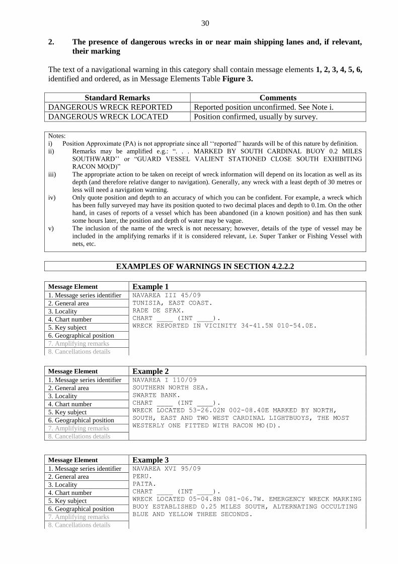
2. The presence of dangerous wrecks in or near main shipping lanes and, if relevant,
their marking
The text of a navigational warning in this category shall contain message elements 1, 2, 3, 4, 5, 6,
identified and ordered, as in Message Elements Table Figure 3.
Standard Remarks Comments
DANGEROUS WRECK REPORTED Reported position unconfirmed. See Note i.
DANGEROUS WRECK LOCATED Position confirmed, usually by survey.
Notes:
i) Position Approximate (PA) is not appropriate since all „„reported‟‟ hazards will be of this nature by definition.
ii) Remarks may be amplified e.g.: “. . . MARKED BY SOUTH CARDINAL BUOY 0.2 MILES
SOUTHWARD‟‟ or “GUARD VESSEL VALIENT STATIONED CLOSE SOUTH EXHIBITING
RACON MO(D)”
iii) The appropriate action to be taken on receipt of wreck information will depend on its location as well as its
depth (and therefore relative danger to navigation). Generally, any wreck with a least depth of 30 metres or
less will need a navigation warning.
iv) Only quote position and depth to an accuracy of which you can be confident. For example, a wreck which
has been fully surveyed may have its position quoted to two decimal places and depth to 0.1m. On the other
hand, in cases of reports of a vessel which has been abandoned (in a known position) and has then sunk
some hours later, the position and depth of water may be vague.
v) The inclusion of the name of the wreck is not necessary; however, details of the type of vessel may be
included in the amplifying remarks if it is considered relevant, i.e. Super Tanker or Fishing Vessel with
nets, etc.
EXAMPLES OF WARNINGS IN SECTION 4.2.2.2
Message Element Example 1 1. Message series identifier NAVAREA III 45/09
TUNISIA, EAST COAST.
RADE DE SFAX.
CHART ____ (INT ____).
WRECK REPORTED IN VICINITY 34-41.5N 010-54.0E.
2. General area
3. Locality
4. Chart number
5. Key subject
6. Geographical position
7. Amplifying remarks
8. Cancellations details
Message Element Example 2 1. Message series identifier NAVAREA I 110/09
SOUTHERN NORTH SEA.
SWARTE BANK.
CHART ____ (INT ____).
WRECK LOCATED 53-26.02N 002-08.40E MARKED BY NORTH,
SOUTH, EAST AND TWO WEST CARDINAL LIGHTBUOYS, THE MOST
WESTERLY ONE FITTED WITH RACON MO(D).
2. General area
3. Locality
4. Chart number
5. Key subject
6. Geographical position
7. Amplifying remarks
8. Cancellations details
Message Element Example 3 1. Message series identifier NAVAREA XVI 95/09
PERU.
PAITA.
CHART ____ (INT ____).
WRECK LOCATED 05-04.8N 081-06.7W. EMERGENCY WRECK MARKING
BUOY ESTABLISHED 0.25 MILES SOUTH, ALTERNATING OCCULTING
BLUE AND YELLOW THREE SECONDS.
2. General area
3. Locality
4. Chart number
5. Key subject
6. Geographical position
7. Amplifying remarks
8. Cancellations details
31
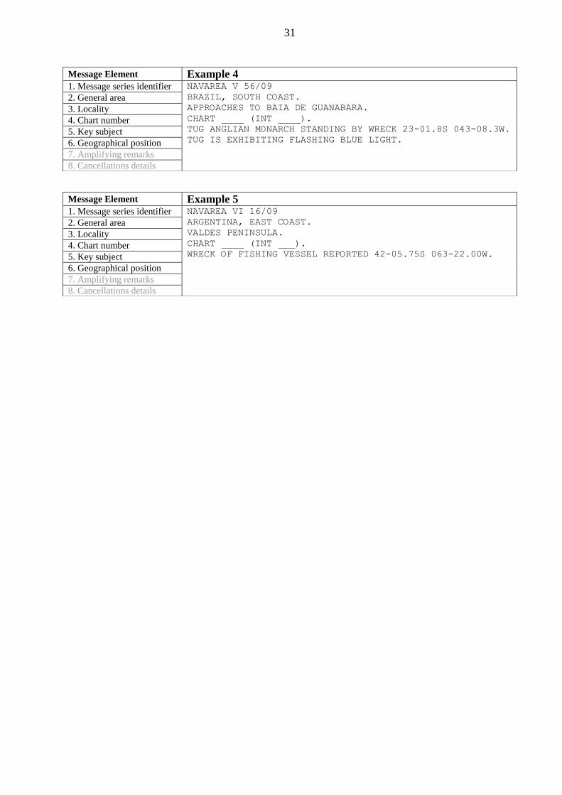
Message Element Example 4 1. Message series identifier NAVAREA V 56/09
BRAZIL, SOUTH COAST.
APPROACHES TO BAIA DE GUANABARA.
CHART ____ (INT ____).
TUG ANGLIAN MONARCH STANDING BY WRECK 23-01.8S 043-08.3W.
TUG IS EXHIBITING FLASHING BLUE LIGHT.
2. General area
3. Locality
4. Chart number
5. Key subject
6. Geographical position
7. Amplifying remarks
8. Cancellations details
Message Element Example 5 1. Message series identifier NAVAREA VI 16/09
ARGENTINA, EAST COAST.
VALDES PENINSULA.
CHART ____ (INT ___).
WRECK OF FISHING VESSEL REPORTED 42-05.75S 063-22.00W.
2. General area
3. Locality
4. Chart number
5. Key subject
6. Geographical position
7. Amplifying remarks
8. Cancellations details

32
3. Establishment of major new aids to navigation or significant changes to existing
ones when such establishment or change, might be misleading to shipping
The text of a navigational warning in this category shall contain message elements 1, 2, 3, 4, 5, 6,
identified and ordered, as in Message Elements Table Figure 3.
Standard Remarks Comments
ESTABLISHED The use of the word ESTABLISHED conveys that
the position and operation of the new or changed
aid has been accurately confirmed by the
appropriate competent authority.
RE-ESTABLISHED For previously charted or listed as DESTROYED or
TEMPORARILY REMOVED. See Note ix.
Notes:
i) Use CHARTED names, not LISTED names.
ii) LIGHT LIST number is not required.
iii) POSITION normally quoted to nearest whole minute for existing lights.
iv) For new lights or changed positions, quote accurate CHARTED position; in degrees, minutes and decimal
minutes (maximum 2 decimal places).
v) Always quote FULL LIGHT CHARACTERISTIC to avoid confusion over what has been changed.
vi) Damage to DAYMARKS is not usually worthy a navigational warning.
vii) Use light descriptions as given in the LIGHTS GLOSSARY OF TERMS Table.
viii) Distances shall be quoted in nautical miles and decimals.
ix) RE-ESTABLISHED is only appropriate for aids which have previously been CHARTED or LISTED as
DESTROYED or TEMPORARILY REMOVED. Navigational Warnings concerning such aids are
cancelled when the aid is re-established. A new Navigational Warning is only required if the characteristics
or position has changed.
x) For new buoys, lanbys, superbuoys or changed positions, quote accurate CHARTED position; in degrees,
minutes and decimal minutes (maximum 2 decimal places). xi) Chart INT 1 Abbreviations for light characters are only suitable for NAVTEX or SafetyNET transmissions.
Voice broadcasts shall be drafted using the terms for lights in the LIGHTS GLOSSARY OF TERMS
Table.
EXAMPLES OF WARNINGS IN SECTION 4.2.2.3
Message Element Example 1 1. Message series identifier NAVAREA IV 210/09
JAMAICA, SOUTHWARDS.
PEDRO BANK.
CHART _____ (INT ____)
SOUTHWEST ROCK LIGHT, FL (3) 10 SECONDS 7 METRES 5M
ESTABLISHED 16-47.55N 078-11.48W.
2. General area
3. Locality
4. Chart number
5. Key subject
6. Geographical position
7. Amplifying remarks
8. Cancellations details
Message Element Example 2 1. Message series identifier NAVAREA V 23/09
BRAZIL, SOUTH COAST.
ILHA RASA SOUTHEASTWARD.
CHART ____ (INT ____).
1. EIGHT UNLIT LARGE SPHERICAL ORANGE BUOYS ESTABLISHED WITHIN 1 MILE RADIUS OF 24-17.8S 042-39.8W.
EXPLORATION IN PROGRESS WITHIN THIS AREA 15 APR
TO 15 MAY 09.
2. CANCEL THIS MSG 160300 UTC MAY 09.
2. General area
3. Locality
4. Chart number
5. Key subject
6. Geographical position
7. Amplifying remarks
8. Cancellations details

33
Message Element Example 3 1. Message series identifier NAVAREA X 15/09
AUSTRALIA - NORTH WEST COAST.
PORT HEDLAND, NORTHWARDS.
CHART ____ (INT ____).
E2 SOUTH CARDINAL LIGHTBUOY ESTABLISHED 20-03.08S 118-
32.82E.
2. General area
3. Locality
4. Chart number
5. Key subject
6. Geographical position
7. Amplifying remarks
8. Cancellations details
Message Element Example 4 1. Message series identifier NAVAREA I 245/09
ENGLAND - WEST COAST.
LIVERPOOL APPROACH.
CHART ____ (INT ____).
LIGHTBUOYS ESTABLISHED MARKING BURBO WINDFARM
CONSTRUCTION AREA.
A. WEST CARDINAL 53-30.21N 003-13.56W.
B. WEST CARDINAL 53-29.70N 003-13.79W.
C. SOUTH CARDINAL 53-28.22N 003-11.10W.
2. General area
3. Locality
4. Chart number
5. Key subject
6. Geographical position
7. Amplifying remarks
8. Cancellations details

34
4. The presence of large unwieldy tows in congested waters
The text of a navigational warning in this category shall contain message elements 1, 2, 3, 5, 6, 7,
identified and ordered, as in Message Elements Table Figure 3.
Standard Remarks Comments
LENGTH OF TOW
Notes:
i) Regular communications should be undertaken with the operators of the tow to ensure that the message is
cancelled promptly as soon as the operation has been completed. Particular care should be taken when
considering including a cancellation time or date for this category of message due to the many factors
which could effect the completion of the operation.
ii) The name or type of the towing vessel and/or towed object should be included when known.
iii) Amplifying remarks regarding length and speed of tow need only be included if relevant or significant.
iv) Amplifying remarks regarding the necessity for “WIDE BERTH” should only be included if specifically
requested by the operator as it will always be the case that the towing vessel and towed object will have
restricted manoeuvrability.
EXAMPLES OF WARNINGS IN SECTION 4.2.2.4
Message Element Example 1 1. Message series identifier NAVAREA VII 58/09
SOUTH ATLANTIC OCEAN.
TUG RIG DELIVERER WILL TOW VESSEL AGATE ISLAND FROM
RECIFE, BRASIL TO CAPE TOWN, COMMENCING 09 JUN 09, ETA
CAPE TOWN ON 09 JUL 09. LENGTH OF TOW 550 METRES WIDE
BERTH REQUESTED.
2. General area
3. Locality
4. Chart number
5. Key subject
6. Geographical position
7. Amplifying remarks
8. Cancellations details
Message Element Example 2 1. Message series identifier NAVAREA XI 76/09
KYUSHU - WEST COAST TO EASTERN CHINA SEA.
TUG TOWING DRILLING RIG KURYU NR 3. DEPARTS NAGASAKI KO
ETD 010100 UTC JUL 09 TO EASTERN CHINA SEA,
29-37.5N 125-49.8E, VIA 31-45N 128-51E. SPEED 5 KNOTS.
ETA 060300 UTC JUL 09. LENGTH OF TOW 1000 METRES.
2. General area
3. Locality
4. Chart number
5. Key subject
6. Geographical position
7. Amplifying remarks
8. Cancellations details
Message Element Example 3 1. Message series identifier NAVAREA XIII 34/09
SEA OF JAPAN.
PROLIV LAPERUZA AND SAKHALIN NORTH EAST COAST.
TUG TOWING DRILLING RIG PA-B 04,18 JUN 09 FROM
34-58.1N 128-48.3E TO 52-55.9N 143-29.9E, VIA
45-43.0N 141-58.0E, 45-45.0N 142-30.0E,
45-49.0N 143-19.0E, 45-55.0N 143-40.0E,
52-52.0N 143-39.5E,
LENGTH OF TOW 1000 METRES SPEED 4.2 KNOTS. ONE MILE BERTH
REQUESTED.
2. General area
3. Locality
4. Chart number
5. Key subject
6. Geographical position
7. Amplifying remarks
8. Cancellations details

35
Message Element Example 4 1. Message series identifier NAVAREA III 65/09
BLACK SEA.
ROMANIA.
GSP KING TOWING PLATFORM JUPITER 060030 UTC AUG 09 FROM
44-31.9N 029-28.0E TO 44-35.9N 029-21.5E.
2. General area
3. Locality
4. Chart number
5. Key subject
6. Geographical position
7. Amplifying remarks
8. Cancellations details
Message Element Example 5 1. Message series identifier NAVAREA I 145/09
SCOTLAND - EAST COAST.
NOSS HEAD SOUTH-EASTWARDS TO KITTIWAKE OIL FIELD
TOW OF SEMI-SUBMERGED PIPELINE BUNDLE IN PROGRESS IN
VICINITY OF LINE JOINING:
58-30N 003-08W, 58-28N 001-51W, 58-16N 000-48W,
58-05N 000-28W, 57-43N 000-11W AND 57-32N 000-10E.
2. General area
3. Locality
4. Chart number
5. Key subject
6. Geographical position
7. Amplifying remarks
8. Cancellations details

36
5. Drifting hazards (including derelict vessels, ice, mines, containers, other large
items, etc.)
The text of a navigational warning in this category shall contain message elements 1, 2, 3, 5, 6, 7, 8,
identified and ordered, as in Message Elements Table Figure 3.
Standard Remarks Comments
REPORTED The time of the latest position report shall
ALWAYS be included. ADRIFT
ADRIFT IN VICINITY
Notes:
i) It is recommended that messages concerning drifting hazards should self cancel within 72 hours. ii) Drifting objects (with the exception of mines) of less than 6 metres in length are not normally considered to
be hazards to navigation and therefore should not be promulgated.
EXAMPLES OF WARNINGS IN SECTION 4.2.2.5
Message Element Example 1 1. Message series identifier NAVAREA VIII 35/09
INDIA WEST COAST.
OFF MURUD JANJIRA.
1. LARGE RECTANGULAR PARTIALLY SUBMERGED METALLIC OBJECT ADRIFT IN VICINITY 18-16.15N 072–24.05E AT 150830 UTC
JUN 09.
2. CANCEL THIS MSG 180830 UTC JUN 09.
2. General area
3. Locality
4. Chart number
5. Key subject
6. Geographical position
7. Amplifying remarks
8. Cancellations details
Message Element Example 2 1. Message series identifier NAVAREA II 78/09
PAZENN.
1. SIX CONTAINERS ADRIFT IN VICINITY 47-37N 006-26W AT 262200 UTC JUL 09.
2. CANCEL THIS MSG 292200 UTC JUL 09.
2. General area
3. Locality
4. Chart number
5. Key subject
6. Geographical position
7. Amplifying remarks
8. Cancellations details
Message Element Example 3 1. Message series identifier NAVAREA I 112/09
CELTIC SEA.
CELTIC DEEP.
1. DERELICT FISHING VESSEL REPORTED ADRIFT 51-25.5N 006-21.9W AT 132210 UTC NOV 09.
2. CANCEL THIS MSG 162210 UTC NOV 09.
2. General area
3. Locality
4. Chart number
5. Key subject
6. Geographical position
7. Amplifying remarks
8. Cancellations details
37
Message Element Example 4 1. Message series identifier NAVAREA IV 75/09
MEXICO.
PLAYA DEL CARMEN APPROACH.
1. DRIFTING MINE REPORTED 20-37.3N 087-03.1W AT 060850 UTC AUG 09.
2. CANCEL THIS MSG 090850 UTC AUG 09.
2. General area
3. Locality
4. Chart number
5. Key subject
6. Geographical position
7. Amplifying remarks
8. Cancellations details
Message Element Example 5 1. Message series identifier NAVAREA VI 99/09
SOUTH ATLANTIC.
WEST SCOTIA RIDGE, RHINE BANK
1. ICEBERGS REPORTED AT 250130 UTC JUL:
A. 55-27.9S 053-35.6W.
B. 55-26.2S 053-18.3W.
2. CANCEL THIS MSG 280130 UTC JUL 09.
2. General area
3. Locality
4. Chart number
5. Key subject
6. Geographical position
7. Amplifying remarks
8. Cancellations details
Message Element Example 6 1. Message series identifier NAVAREA IV 55/09
WEST INDIES. MARTINIQUE, SOUTH. 1. LARGE TRUNK, ELEVEN METRES IN LENGTH, REPORTED IN
VICINITY 14-14N 060–52W AT 272115 UTC AUG 09. 2. CANCEL THIS MSG 302115 UTC AUG 09.
2. General area
3. Locality
4. Chart number
5. Key subject
6. Geographical position
7. Amplifying remarks
8. Cancellations details

38
6. Areas where search and rescue (SAR) and anti-pollution operations are being
carried out (for avoidance of such areas)
The text of a navigational warning in this category shall contain message elements 1, 2, 3, 5, 6, 7,
identified and ordered, as in Message Elements Table Figure 3.
Standard Remarks Comments
SAR OPERATION
ANTIPOLLUTION OPERATIONS
EXAMPLES OF WARNINGS IN SECTION 4.2.2.6
Message Element Example 1 1. Message series identifier NAVAREA XIV 67/09
NEW ZEALAND.
COOK STRAIT.
SAR OPERATION IN PROGRESS CENTRED ON 40-24.5S 173-57.6E.
ALL VESSELS NOT UNDER INSTRUCTION OF THE SAR MISSION
CONTROLLER RCCNZ ARE REQUESTED TO KEEP A WIDE BERTH.
2. General area
3. Locality
4. Chart number
5. Key subject
6. Geographical position
7. Amplifying remarks
8. Cancellations details
Message Element Example 2 1. Message series identifier NAVAREA I 25/09
ENGLAND SOUTH COAST.
LYME BAY, BEER HEAD WESTWARDS.
ANTIPOLLUTION OPERATIONS IN PROGRESS 50-40.0N 003-10.0W.
A TEMPORARY EXCLUSION ZONE RADIUS TWO MILES HAS BEEN
ESTABLISHED CENTRED ON THIS POSITION. VESSELS ARE
PROHIBITED FROM ENTERING OR REMAINING WITHIN THIS ZONE.
2. General area
3. Locality
4. Chart number
5. Key subject
6. Geographical position
7. Amplifying remarks
8. Cancellations details
Message Element Example 3 1. Message series identifier NAVAREA IV 6/09
GULF OF MEXICO.
MISSISSIPPI RIVER.
THE CAPTAIN OF THE PORT, NEW ORLEANS 23-00N 90-00W HAS
ESTABLISHED A SAFETY ZONE FROM SOUTHWEST PASS BUOY,
INCLUDING BAPTISTE COLLETTE, TIGER PASS AND SOUTH PASS TO
MM 98, LOWER MISSISSIPPI RIVER, ABOVE HEAD OF PASSES,
EXTENDING THE ENTIRE WIDTH OF THE RIVER. THIS SAFETY
ZONE IS NEEDED TO PROTECT PERSONS AND VESSELS FROM THE
HAZARDS ASSOCIATED WITH AN OIL SPILL FROM A COLLISION
INVOLVING A TANK SHIP AND RED FLAG BARGE.
ALL VESSELS ARE PROHIBITED FROM ENTERING THIS SAFETY ZONE
UNLESS THEY HAVE BEEN GRANTED PERMISSION BY THE CAPTAIN
OF THE PORT, NEW ORLEANS. ALL INBOUND VESSELS BOUND FOR
BERTHS IN THE AFFECTED ZONE ARE REQUIRED TO STAY OUTSIDE
SOUTHWEST PASS.
CONTACT CAPTAIN OF PORT FOR UPDATED INFORMATION.
2. General area
3. Locality
4. Chart number
5. Key subject
6. Geographical position
7. Amplifying remarks
8. Cancellations details

39
7. The presence of newly discovered rocks, shoals, reefs and wrecks likely to constitute
a danger to shipping, and, if relevant, their marking
The text of a navigational warning in this category shall contain message elements 1, 2, 3, 4, 5, 6,
identified and ordered, as in Message Elements Table Figure 3.
Standard Remarks Comments
LOCATED The word LOCATED should only be used when the
position of the hazard has been confirmed by a
hydrographic survey. In all other cases the word
REPORTED should be used. REPORTED
LESS WATER REPORTED
SIGNIFICANTLY LESS WATER THAN
CHARTED REPORTED
Notes:
i) Due consideration should be taken over the inclusion of a specific depth over a newly discovered
submerged hazard to navigation. The terms “LESS WATER REPORTED” or “SIGNIFICANTLY LESS
WATER THAN CHARTED REPORTED” may be used prior to a report of survey of the area.
EXAMPLES OF WARNINGS IN SECTION 4.2.2.7
Message Element Example 1 1. Message series identifier NAVAREA XII 222/09
COSTA RICA.
SOUTHWEST COAST.
CHART ____ (INT ____).
SHOALS LOCATED:
A. 28 METRES 08-17.1N 083-53.1W.
B. 13.5 METRES 08-19.2N 083-54.2W.
C. 27 METRES 08-21.8N 083-56.1W.
2. General area
3. Locality
4. Chart number
5. Key subject
6. Geographical position
7. Amplifying remarks
8. Cancellations details
Message Element Example 2 1. Message series identifier NAVAREA IV 231/09
NORTH PACIFIC OCEAN.
JASPER SEAMOUNT.
CHART ____ (INT ____).
DISCOLOURED WATER WITH SUBMARINE VOLCANIC ACTIVITY
REPORTED VICINITY 30-27N 122-40W AT 190110 UTC FEB 09.
2. General area
3. Locality
4. Chart number
5. Key subject
6. Geographical position
7. Amplifying remarks
8. Cancellations details
Message Element Example 3 1. Message series identifier NAVAREA VII 48/09
ANGOLA.
PORT OF LUANDA.
CHART ____ (INT ____).
WRECK LOCATED 08-16.50S 013–16.07E. LEAST DEPTH EIGHT
METRES.
2. General area
3. Locality
4. Chart number
5. Key subject
6. Geographical position
7. Amplifying remarks
8. Cancellations details
Message Element Example 4

40
1. Message series identifier NAVAREA I 432/09
ORKNEY ISLANDS.
WESTRAY FIRTH.
CHART ____ (INT ____).
SHOAL DEPTH 10.9 METRES LOCATED 59-12.979N 002-54.962W.
2. General area
3. Locality
4. Chart number
5. Key subject
6. Geographical position
7. Amplifying remarks
8. Cancellations details
Message Element Example 5 1. Message series identifier NAVAREA XVI 98/09
PERU.
BAHIA DEL CALLAO.
CHART ____ (INT ____).
SIGNIFICANTLY LESS WATER THAN CHARTED REPORTED
11-59.89S 077-17.50W.
2. General area
3. Locality
4. Chart number
5. Key subject
6. Geographical position
7. Amplifying remarks
8. Cancellations details

41
8. Unexpected alteration or suspension of established routes
The text of a navigational warning in this category shall contain message elements 1, 2, 3, 5, 6, 7,
identified and ordered, as in Message Elements Table Figure 3.
EXAMPLES OF WARNINGS IN SECTION 4.2.2.8
Message Element Example 1 1. Message series identifier NAVAREA I 67/09
ENGLAND - EAST COAST.
THAMES ESTUARY NORTHERN APPROACHES.
WITH EFFECT FROM 010001 UTC JUL 09 EXTENSIVE CHANGES TO
ROUTEING AND BUOYAGE WILL BE IMPLEMENTED TO SEAWARD OF
AND IN THE SUNK AREA 51-50N 001-46E. FOR FULL DETAILS
REFER TO ADMIRALTY NOTICE TO MARINERS 534(P)/09 AND
RELEVANT NEW EDITIONS OF ADMIRALTY CHARTS PUBLISHED IN
MAY AND JUNE 09. THE CURRENT SUNK VTS IS CANCELLED AT
010001 UTC JULY UNTIL FURTHER NOTICE. VESSELS REQUIRING A
PILOT SHOULD CONTACT SUNK PILOTAGE SERVICE VHF CHANNEL 9.
2. General area
3. Locality
4. Chart number
5. Key subject
6. Geographical position
7. Amplifying remarks
8. Cancellations details
Message Element Example 2 1. Message series identifier NAVAREA X 234/09
AUSTRALIA NORTH COAST.
TORRES STRAIT.
CHART ____ (INT ____).
COMPULSORY TORRES STRAIT PILOTAGE 10-32S 143-01E.
MASTERS OF VESSELS 70 METRES IN LENGTH OVERALL OR
GREATER, AND ALL LOADED OIL, CHEMICAL TANKERS OR
LIQUEFIED GAS CARRIERS ARE ADVISED THAT AUSTRALIAN LAW
HAS BEEN AMENDED TO REQUIRE A LICENSED PILOT TO BE
ENGAGED WHEN NAVIGATING THE TORRES STRAIT.
ALL VESSELS WILL BE AUTOMATICALLY CHECKED FOR COMPLIANCE
AND THE FAILURE TO EMBARK A LICENSED PILOT MAY RESULT IN
PROSECUTION.
MASTERS OF VESSELS SHOULD ENSURE CONTACT IS MADE IN A
TIMELY MANNER WITH A PILOTAGE PROVIDER TO GUARANTEE A
LICENSED PILOT IS BOOKED.
THE FOLLOWING ARE THE CONTACT DETAILS OF THE TWO
COMPANIES THAT CAN PROVIDE LICENSED PILOTS:
AUSTRALIAN REEF PILOTS PTY LTD.
TORRES PILOTS PTY LTD - [email protected].
2. General area
3. Locality
4. Chart number
5. Key subject
6. Geographical position
7. Amplifying remarks
8. Cancellations details
Message Element Example 3 1. Message series identifier NAVAREA XI 07/09
MALAYSIA SOUTH COAST.
SINGAPORE.
WEST JURONG CHANNEL WILL BE CLOSED FROM 0100 TO 0600 UTC
DAILY 02 THRU 20 JAN WHILE REPLACING ALL CHANNEL BUOYS.
MASTERS OF VESSELS SHOULD CONTACT SINGAPORE PORT
OPERATIONS AT LEAST 48 HOURS IN ADVANCE PRIOR TO ENTERING
OR LEAVING THE WEST JURONG CHANNEL TO ENSURE PILOTS ARE
ENGAGED IN A TIMELY MANNER. CONTACT INFORMATION IS AS
FOLLOWS. PHONE: 65-62265539, FAX: 65-62279971.
2. General area
3. Locality
4. Chart number
5. Key subject
6. Geographical position
7. Amplifying remarks
8. Cancellations details

42
Message Element Example 4 1. Message series identifier NAVAREA V 206/09
BRAZIL - SOUTH COAST.
1. NAVAL CONTROL EXERCISE 091900 UTC TO 130300 UTC NOV
09 IN AREA BOUNDED BY:
31-33.00S 051-14.50W, 32-17.50S 050-07.00W,
33-51.00S 051-33.50W, 33-07.00S 052-38.00W.
A. MERCHANT VESSELS SHOULD CROSS MARITIME AREA USING THE
FOLLOWING LANES:
i) LANE COASTAL-1: (DIRECTION NE-SW)
32-00.00S 050-50.00W AND 33-20.00S 052-03.00W.
ii) LANE COASTAL-2: (NC2-PORT RIO GRANDE)
32-38.00S 051-25.00W AND 32-15.00S 051-58.00W.
B. WIDTH OF LANE IS SIX NAUTICAL MILES, THREE NAUTICAL
MILES ON EACH SIDE OF THE TRACKLINE JOINING:
i) NC1: 32-00.00S 050-50.00W.
ii) NC2: 32-38.00S 051-25.00W.
iii) NC3: 33-20.00S 052-03.00W.
C. ACCESS AND DEPART RIO GRANDE PORT FROM:
32-15.00S 051-58.00W.
D. ACCORDING TO ENTERING POSITION, MERCHANT VESSELS IN
THE AREA SHOULD CALL LANE CONTROLLER VESSELS BY VHF
CHANNELS 16 AND 10, USING THE FOLLOWING:
i) NC1 CONTROLLER OF MERCHANT VESSELS ENTERING AND
LEAVING BY NORTHEAST OF AREA.
ii) NC2 CONTROLLER OF MERCHANT VESSELS REQUESTING AND
LEAVING FROM POINT OF ACCESS AND DEPART OF RIO
GRANDE PORT.
iii) NC3 CONTROLLER OF MERCHANT VESSELS ENTERING AND
LEAVING BY SOUTHWEST OF AREA.
CAUTION ADVISED.
2. CANCEL THIS MSG 130400 UTC NOV 09.
2. General area
3. Locality
4. Chart number
5. Key subject
6. Geographical position
7. Amplifying remarks
8. Cancellations details
Message Element Example 5 1. Message series identifier NAVAREA IV 351/09
NORTH ATLANTIC.
NORTH CAROLINA.
1. THE PORTS FOR NORTH CAROLINA HAVE BEEN CLOSED UNTIL FURTHER NOTICE IN PREPARATION FOR THE ANTICIPATED
IMPACT OF HURRICANE HANNA. ALL INLAND WATERS, COASTAL
INLETS AND TERRITORIAL SEAS WITHIN THE CAPTAIN OF THE
PORT ZONE, FROM LITTLE RIVER INLET TO THE NORTH
CAROLINA – VIRGINIA BOUNDARY HAS BEEN ESTABLISHED. NO
VESSEL MAY ENTER, DEPART OR TRANSIT WITHIN THIS SAFETY
ZONE WITHOUT THE PERMISSION OF THE CAPTAIN OF THE
PORT.
2. ALL CARGO AND BUNKER HANDLING OPERATIONS MUST CEASE. 3. CONTACT CAPTAIN OF PORT FOR UPDATED INFORMATION.
2. General area
3. Locality
4. Chart number
5. Key subject
6. Geographical position
7. Amplifying remarks
8. Cancellations details

43
9. Cable or pipe-laying activities, the towing of large submerged objects for research or
exploration purposes, the employment of manned or unmanned submersibles, or
other underwater operations constituting potential dangers in or near shipping lanes
The text of a navigational warning in this category shall contain message elements 1, 2, 3, 5, 6, 7,
identified and ordered, as in Message Elements Table Figure 3.
Standard Remarks Comments
CABLE LAYING OPERATIONS IN
PROGRESS
SEISMIC SURVEY IN PROGRESS
UNDERWATER OPERATIONS Do not use “SUBMARINE OPERATIONS”
SCIENTIFIC OPERATIONS IN
PROGRESS
Notes:
i) Regular communications should be undertaken with the operators to ensure that the message is cancelled
promptly as soon as the operation has been completed. Particular care should be taken when considering
including a cancellation time or date for this category of message due to the many factors which could
effect the completion of the operation.
ii) Use “REQUESTED” when wide berth is for the benefit of the ship which is performing the operation.
iii) Use “ADVISED” when the operations create a significant hazard.
EXAMPLES OF WARNINGS IN SECTION 4.2.2.9
Message Element Example 1 1. Message series identifier NAVAREA VII 256/09
ATLANTIC OCEAN.
ANGOLA.
M/V GECO EMERALD IS CONDUCTING SEISMIC SURVEY OPERATIONS
AND TOWING SIX STREAMERS AT 8000 METRE LENGTH WITH ENDS
MARKED WITH YELLOW BUOYS AND BLUE FLASHING LIGHTS IN AREA
BOUNDED BY 10-55S, 11-21S, 013-20E AND 012-40E. WIDE
BERTH REQUESTED, MINIMUM SIX MILE ASTERN AND THREE MILES
ABEAM. SURVEY VESSEL STANDING BY ON VHF CH 67 AND 16.
GUARD VESSEL ST JOHNS IN ATTENDANCE.
2. General area
3. Locality
4. Chart number
5. Key subject
6. Geographical position
7. Amplifying remarks
8. Cancellations details
Message Element Example 2 1. Message series identifier NAVAREA IX 15/09
RED SEA.
GULF OF SUEZ.
VESSEL TIME BARGE IS WORKING ON HILAL PLATFORM MOORED
WITH EIGHT ANCHORS AND BUOYS IN FOLLOWING POSITIONS:
A. 27-49.98N 033-43.82E.
B. 27-50.21N 033-43.67E.
C. 27-50.29N 033-43.36E.
D. 27-50.41N 033-43.45E.
E. 27-50.06N 033-44.41E.
F. 27-50.18N 033-44.03E.
G. 27-50.50N 033-43.74E.
H. 27-50.50N 033-43.61E.
WIDE BERTH REQUESTED.
2. General area
3. Locality
4. Chart number
5. Key subject
6. Geographical position
7. Amplifying remarks
8. Cancellations details

44
Message Element Example 3 1. Message series identifier NAVAREA XIII 55/09
TATARSKIY PROLIV.
PROLIV LAPERUZA.
1. CABLE LAYING OPERATIONS IN PROGRESS BY VESSEL SUBARU TOWING 2000 METRE CABLE UNTIL 30 JUN 09 ALONG LINE
JOINING 45–56.8N 140–00.7E, 46–36.5N 140–53.6E,
46-36.6N 141–29.0E, 46–38.9N 141–47.3E, 46–36.5N
141-49.8E. WIDE BERTH REQUESTED.
2. CANCEL THIS MSG 020001 UTC JUL 09.
2. General area
3. Locality
4. Chart number
5. Key subject
6. Geographical position
7. Amplifying remarks
8. Cancellations details
Message Element Example 4 1. Message series identifier NAVAREA VIII 361/09
INDIAN OCEAN.
SONGO AND MAFIA ISLANDS.
SEISMIC SURVEY IN PROGRESS BY M/V GEO MARINER IN AREA
BOUNDED BY:
A. 07-32S 039-18E.
B. 07-37S 040-17E.
C. 06-22S 039-50E.
D. 06-35S 039-09E.
VESSEL TOWING FOUR MILE SEISMIC CABLE WITH YELLOW TAIL
BUOY AND FLASHING LIGHT AT THE END OF THE CABLE.
SIX MILE BERTH REQUESTED.
2. General area
3. Locality
4. Chart number
5. Key subject
6. Geographical position
7. Amplifying remarks
8. Cancellations details
Message Element Example 5 1. Message series identifier NAVAREA IV 20/09
NORTH ATLANTIC OCEAN.
TRINIDAD, EASTWARDS.
1. PIPELAYING OPERATIONS IN PROGRESS UNTIL 31 JUL 09 BY M/V SOLITAIRE AND M/V HIGHLAND NAVIGATOR ALONG TRACK
BETWEEN 10-02.28N 060-15.08W AND 10-06.08N
060-17.81W. WIDE BERTH REQUESTED.
2. CANCEL THIS MESSAGE 010001 UTC AUG 09.
2. General area
3. Locality
4. Chart number
5. Key subject
6. Geographical position
7. Amplifying remarks
8. Cancellations details

45
10. The establishment of research or scientific instruments in or near shipping lanes
The text of a navigational warning in this category shall contain message elements 1, 2, 3, 4, 5, 6,
identified and ordered, as in Message Elements Table Figure 3.
EXAMPLES OF WARNINGS IN SECTION 4.2.2.10
Message Element Example 1 1. Message series identifier NAVAREA X 77/09
AUSTRALIA WEST COAST.
EXMOUTH PLATEAU.
CHART ____ (INT ____).
SUBSEA MOORING BUOY ESTABLISHED 21-26S 114-04E. BUOY
MARKED WITH MOORING LINE AND SMALL FLOAT. WIDE BERTH
REQUESTED.
2. General area
3. Locality
4. Chart number
5. Key subject
6. Geographical position
7. Amplifying remarks
8. Cancellations details
Message Element Example 2 1. Message series identifier NAVAREA VII 321/09
MADAGASCAR.
PORT OF MAJUNGA.
CHART ____ (INT ____).
TWO TIDE GAUGES AND A CURRENT METER MOORED IN AREA
BOUNDED BY:
15-32.70S, 15-33.03S, 046-11.77E AND 046-11.53E.
2. General area
3. Locality
4. Chart number
5. Key subject
6. Geographical position
7. Amplifying remarks
8. Cancellations details
Message Element Example 3 1. Message series identifier NAVAREA IV 333/09
NORTH ATLANTIC OCEAN.
GRAND BANKS OF NEWFOUNDLAND.
CHART ____ (INT ____).
DART BUOY ESTABLISHED 44-04.58N 055-12.80W.
2. General area
3. Locality
4. Chart number
5. Key subject
6. Geographical position
7. Amplifying remarks
8. Cancellations details
Message Element Example 4 1. Message series identifier NAVAREA III 55/09
IONIAN SEA.
CENTRAL.
CHART ____ (INT ____).
ODAS BUOY ESTABLISHED 38-25.59N 18-20.65E.
2. General area
3. Locality
4. Chart number
5. Key subject
6. Geographical position
7. Amplifying remarks
8. Cancellations details

46
Message Element Example 5 1. Message series identifier NAVAREA XI 66/09
NORTH PACIFIC OCEAN.
CAROLINE ISLANDS AND NGULU ATOL SOUTH-WESTWARDS.
CHART ____ (INT ____).
ODAS BUOY ESTABLISHED IN VICINITY 07-39.0N 136-41.9E.
2. General area
3. Locality
4. Chart number
5. Key subject
6. Geographical position
7. Amplifying remarks
8. Cancellations details

47
11. The establishment of offshore structures in or near shipping lanes
The text of a navigational warning in this category shall contain message elements 1, 2, 3, 5, 6,
identified and ordered, as in Message Elements Table Figure 3.
Note:
i) It is not necessary to number or alphabetizes the list of structures.
EXAMPLES OF WARNINGS IN SECTION 4.2.2.11
Message Element Example 1 1. Message series identifier NAVAREA IX 5/09
RED SEA.
GULF OF SUEZ, TOR BANK.
CHART ____ (INT ____).
MOBILE RIG ESTABLISHED IN 28-12.8N 033-24.1E.
2. General area
3. Locality
4. Chart number
5. Key subject
6. Geographical position
7. Amplifying remarks
8. Cancellations details
Message Element Example 2 1. Message series identifier NAVAREA VII 117/09
SOUTH ATLANTIC OCEAN.
ANGOLA, CONGO, IVORY COAST AND NAMIBIA.
RIG LIST:
05-08.58S 011-55.15E PRIDE CAPINDA.
05-33.08S 011-27.08E PRIDE VENEZUELA.
06-03.81S 011-05.86E GSF RIG 140.
06-19.02S 011-03.23E KIZOMBA A.
06-20.15S 011-18.01E PRIDE SOUTH PACIFIC.
06-20.92S 011-09.22E KIZOMBA B.
07-40.05S 011-45.08E PRIDE AFRICA.
07-43.00S 011-43.00E PRIDE ANGOLA.
35-08.86S 022-31.81E PRIDE SOUTH SEAS.
35-13.99S 021-29.89E ORCA.
FOUR MILE EXCLUSION ZONE ABOUT RIGS DUE TO PRESENCE OF
UNLIT ANCHOR MARKING BUOYS.
2. General area
3. Locality
4. Chart number
5. Key subject
6. Geographical position
7. Amplifying remarks
8. Cancellations details
Message Element Example 3 1. Message series identifier NAVAREA VIII 244/09
INDIA.
WEST COAST.
1. PRESENT POSITION OF OIL RIGS AND DRILL SHIPS:
20-43.00N 072-19.06E ABAN V.
20-18.23N 070-00.03E BADRINATH.
19-54.20N 071-18.95E FRONTIER ICE.
19-29.72N 071-22.89E NOBLE ED HOLT.
19-11.99N 072-11.00E RON TAPPMEYER.
19-40.14N 072-00.33E SAGER RATNA.
19-25.23N 071-16.98E TRIDENT–12.
19-18.23N 072-02.75E ENSCO-50.
19-32.70N 071-13.98E SUNDOWNER–7.
WIDE BERTH REQUESTED.
2. CANCEL NAVAREA VIII 236/09.
2. General area
3. Locality
4. Chart number
5. Key subject
6. Geographical position
7. Amplifying remarks
8. Cancellations details

48
Message Element Example 4 1. Message series identifier NAVAREA I 220/09
1. RIGLIST. CORRECT AT 040600 UTC AUG 09.
SOUTHERN NORTH SEA. 51N TO 55N.
52-54.1N 004-08.5E NOBLE LYNDA BOSSLER.
53-27.7N 002-17.1E ENSCO 100.
NEW 53-39.3N 004-16.9E ENSCO 72.
53-48.3N 002-50.3E NOBLE JULIE ROBERTSON.
53-57.0N 002-13.5E NOBLE AL WHITE.
NEW 54-16.6N 002-12.6E GSF LABRADOR.
54-19.0N 002-37.2E NOBLE GEORGE SAUVAGEAU.
NOTES:
A. RIGS ARE PROTECTED BY A 500 METRE SAFETY ZONE.
B. ACP - ADJACENT TO CHARTED PLATFORM.
2. CANCEL NAVAREA I 225/09.
2. General area
3. Locality
4. Chart number
5. Key subject
6. Geographical position
7. Amplifying remarks
8. Cancellations details
Message Element Example 5 1. Message series identifier NAVAREA VI 116/09
URUGUAY.
MONTEVIDEO.
CHART ____ (INT ____).
PLATFORM AJAX ESTABLISHED 35-00N 056-20W.
2. General area
3. Locality
4. Chart number
5. Key subject
6. Geographical position
7. Amplifying remarks
8. Cancellations details
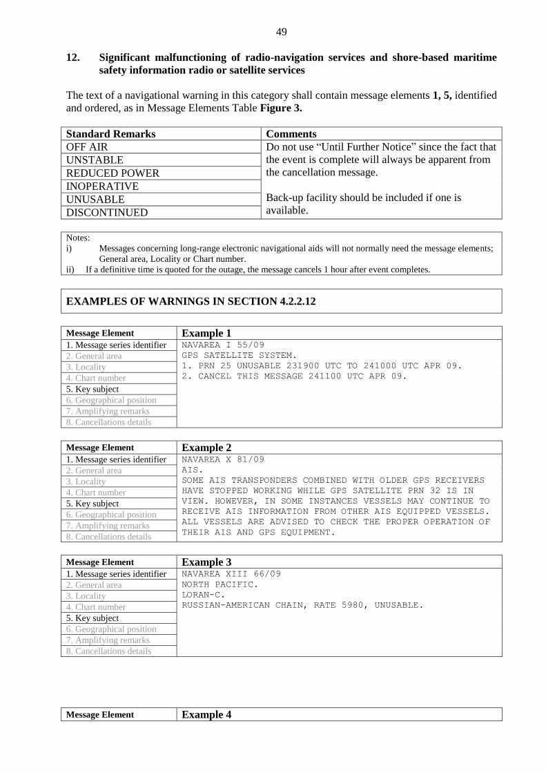
49
12. Significant malfunctioning of radio-navigation services and shore-based maritime
safety information radio or satellite services
The text of a navigational warning in this category shall contain message elements 1, 5, identified
and ordered, as in Message Elements Table Figure 3.
Standard Remarks Comments
OFF AIR Do not use “Until Further Notice” since the fact that
the event is complete will always be apparent from
the cancellation message.
Back-up facility should be included if one is
available.
UNSTABLE
REDUCED POWER
INOPERATIVE
UNUSABLE
DISCONTINUED
Notes:
i) Messages concerning long-range electronic navigational aids will not normally need the message elements;
General area, Locality or Chart number.
ii) If a definitive time is quoted for the outage, the message cancels 1 hour after event completes.
EXAMPLES OF WARNINGS IN SECTION 4.2.2.12
Message Element Example 1 1. Message series identifier NAVAREA I 55/09
GPS SATELLITE SYSTEM.
1. PRN 25 UNUSABLE 231900 UTC TO 241000 UTC APR 09.
2. CANCEL THIS MESSAGE 241100 UTC APR 09.
2. General area
3. Locality
4. Chart number
5. Key subject
6. Geographical position
7. Amplifying remarks
8. Cancellations details
Message Element Example 2 1. Message series identifier NAVAREA X 81/09
AIS.
SOME AIS TRANSPONDERS COMBINED WITH OLDER GPS RECEIVERS
HAVE STOPPED WORKING WHILE GPS SATELLITE PRN 32 IS IN
VIEW. HOWEVER, IN SOME INSTANCES VESSELS MAY CONTINUE TO
RECEIVE AIS INFORMATION FROM OTHER AIS EQUIPPED VESSELS.
ALL VESSELS ARE ADVISED TO CHECK THE PROPER OPERATION OF
THEIR AIS AND GPS EQUIPMENT.
2. General area
3. Locality
4. Chart number
5. Key subject
6. Geographical position
7. Amplifying remarks
8. Cancellations details
Message Element Example 3 1. Message series identifier NAVAREA XIII 66/09
NORTH PACIFIC.
LORAN-C.
RUSSIAN-AMERICAN CHAIN, RATE 5980, UNUSABLE.
2. General area
3. Locality
4. Chart number
5. Key subject
6. Geographical position
7. Amplifying remarks
8. Cancellations details
Message Element Example 4

50
1. Message series identifier NAVAREA I 93/09
GMDSS
SHETLAND ISLANDS.
MRCC SHETLAND. VHF RT AND DSC SERVICES FROM SAXA VORD
SITE, 60-50N 000-50W, OFF AIR.
2. General area
3. Locality
4. Chart number
5. Key subject
6. Geographical position
7. Amplifying remarks
8. Cancellations details
Message Element Example 5 1. Message series identifier NAVAREA IV 43/09
INMARSAT-B
JRCC HALIFAX NORTH ATLANTIC OCEAN.
INMARSAT-B TERMINAL AT JRCC HALIFAX INOPERATIVE. DISTRESS
MESSAGES CAN BE SENT TO JRCC HALIFAX VIA INMARSAT-C.
INMARSAT-B MESSAGES CAN BE DIRECTED TO MCTS HALIFAX
01922510.
2. General area
3. Locality
4. Chart number
5. Key subject
6. Geographical position
7. Amplifying remarks
8. Cancellations details
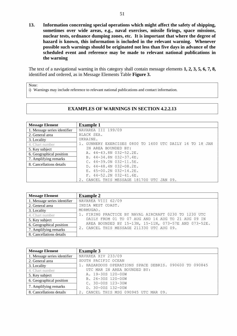
51
13. Information concerning special operations which might affect the safety of shipping,
sometimes over wide areas, e.g., naval exercises, missile firings, space missions,
nuclear tests, ordnance dumping zones, etc. It is important that where the degree of
hazard is known, this information is included in the relevant warning. Whenever
possible such warnings should be originated not less than five days in advance of the
scheduled event and reference may be made to relevant national publications in
the warning
The text of a navigational warning in this category shall contain message elements 1, 2, 3, 5, 6, 7, 8,
identified and ordered, as in Message Elements Table Figure 3.
Note:
i) Warnings may include reference to relevant national publications and contact information.
EXAMPLES OF WARNINGS IN SECTION 4.2.2.13
Message Element Example 1 1. Message series identifier NAVAREA III 199/09
BLACK SEA.
UKRAINE.
1. GUNNERY EXERCISES 0800 TO 1600 UTC DAILY 16 TO 18 JAN
IN AREA BOUNDED BY:
A. 44-43.8N 032-52.2E.
B. 44-34.8N 032-37.4E.
C. 44-39.0N 032-11.5E.
D. 44-48.4N 032-08.2E.
E. 45-00.2N 032-14.2E.
F. 44-52.2N 032-41.6E.
2. CANCEL THIS MESSAGE 181700 UTC JAN 09.
2. General area
3. Locality
4. Chart number
5. Key subject
6. Geographical position
7. Amplifying remarks
8. Cancellations details
Message Element Example 2 1. Message series identifier NAVAREA VIII 62/09
INDIA WEST COAST.
MORMUGAO.
1. FIRING PRACTICE BY NAVAL AIRCRAFT 0230 TO 1230 UTC
DAILY FROM 01 TO 07 AUG AND 14 AUG TO 21 AUG 09 IN
AREA BOUNDED BY 15-13N, 15-11N, 073-57E AND 073-52E.
2. CANCEL THIS MESSAGE 211330 UTC AUG 09.
2. General area
3. Locality
4. Chart number
5. Key subject
6. Geographical position
7. Amplifying remarks
8. Cancellations details
Message Element Example 3 1. Message series identifier NAVAREA XIV 233/09
SOUTH PACIFIC OCEAN
1. HAZARDOUS OPERATIONS SPACE DEBRIS. 090600 TO 090845
UTC MAR IN AREA BOUNDED BY:
A. 19-30S 120-00W
B. 26-30S 120-00W
C. 30-00S 123-30W
D. 30-00S 132-00W
2. CANCEL THIS MSG 090945 UTC MAR 09.
2. General area
3. Locality
4. Chart number
5. Key subject
6. Geographical position
7. Amplifying remarks
8. Cancellations details

52
Message Element Example 4 1. Message series identifier NAVAREA XI 198/09
JAPAN, HONSHU.
NOJIMA SAKI, SOUTHEASTWARD.
1. HAZARDOUS OPERATIONS ROCKET, FLARE FIRING AND BOMBING
FROM 041500 TO 071500 UTC AUG, ALTERNATE FROM 071500
TO 081500 UTC AUG. AREA BOUNDED BY:
A. 34-35.2N 140-16.8E.
B. 34-08.2N 141-01.8E.
C. 33-44.2N 140-22.8E.
D. 34-31.2N 140-07.8E.
2. CANCEL THIS MSG 071600 UTC AUG 09.
2. General area
3. Locality
4. Chart number
5. Key subject
6. Geographical position
7. Amplifying remarks
8. Cancellations details
Message Element Example 5 1. Message series identifier NAVAREA VII 74/09
INDIAN OCEAN.
ILES KERGUELEN NORTH-EASTWARDS.
1. ROCKET LAUNCHING SCHEDULED 0330 TO 0530 UTC 28 APR TO
03 MAY 09. FOLLOWING RANGE CLEARANCE AREA ESTABLISHED:
A. 44–20S 074–45E.
B. 44–20S 077–30E.
C. 49–10S 074–45E.
D. 49–10S 077–30E.
VESSELS TO REMAIN CLEAR OF THIS AREA.
2. CANCEL THIS MESSAGE 030630 UTC MAY 09.
2. General area
3. Locality
4. Chart number
5. Key subject
6. Geographical position
7. Amplifying remarks
8. Cancellations details

53
14. Acts of piracy and armed robbery against ships
The text of a navigational warning in this category shall contain message elements 1, 2, 3, 5, 6,
identified and ordered, as in Message Elements Table Figure 3.
Standard Remarks Comments
ACT OF PIRACY
ARMED ROBBERY
Note:
i) Add amplifying information if available for example, “Regional Piracy Centre, KUALA LUMPUR, TEL,
FAX, E-MAIL”:
EXAMPLES OF WARNINGS IN SECTION 4.2.2.14
Message Element Example 1 1. Message series identifier NAVAREA IX 99/09
GULF OF ADEN.
M/V ALWAYS SAIL REPORTS ACT OF PIRACY/ARMED ROBBERY IN
VICINITY 11-50N 048-60E AT 120600 UTC AUG 09. TWO ZODIACS
CARRYING 3–4 MEN EACH APPROACHING FROM ASTERN AT 20 KNOTS
AT FIRST LIGHT. ATTEMPTED TO BOARD PORT SIDE AFT.
2. General area
3. Locality
4. Chart number
5. Key subject
6. Geographical position
7. Amplifying remarks
8. Cancellations details
Message Element Example 2 1. Message series identifier NAVAREA XI 60/09
MALACCA STRAIT.
PIRACY ATTACKS/ARMED ROBBERY CONCENTRATED IN MALACCA
STRAIT BETWEEN
A. 03-50N 099-25E.
B. 03-49N 100-19E.
C. 03-05N 100-57E.
D. 03-17N 099-50E.
REPORTED ATTACKS ALWAYS OCCUR AT NIGHT. VESSELS ADVISED
TO MAINTAIN ANTI-PIRACY WATCHES. ALL SUSPICIOUS OR
UNEXPLAINED CRAFT MOVEMENTS OR PIRACY ATTACKS SHOULD BE
REPORTED IMMEDIATELY TO THE NEAREST RCC, NATIONAL OR
REGIONAL PIRACY CENTRE OR THE NEAREST POINT ON THE COAST
WITH WHICH THEY CAN COMMUNICATE.
2. General area
3. Locality
4. Chart number
5. Key subject
6. Geographical position
7. Amplifying remarks
8. Cancellations details
Message Element Example 3 1. Message series identifier NAVAREA XV 231/09
CHILE.
ISLA SAN AMBROSIO AND ISLA SAN FELIX.
1. FOUR SPEEDBOATS CARRYING 20 PIRATES, ALL ARMED WITH AUTOMATIC WEAPONS, ATTACKED A FISHING BOAT KILLING
FOUR PASSENGERS AND INJURING EIGHT OTHERS. THE
WOUNDED PASSENGERS WERE SENT TO SHORE FOR MEDICAL
TREATMENT.
2. CANCEL THIS MSG 140001 UTC JUN 09.
2. General area
3. Locality
4. Chart number
5. Key subject
6. Geographical position
7. Amplifying remarks
8. Cancellations details

54
Message Element Example 4 1. Message series identifier NAVAREA II 254/09
NIGERIA.
BONNY RIVER.
TUGBOAT HERKULES, HIJACKED 25 JUL. VESSEL WAS HEADED TO
AKPO OIL FIELD WHEN GUNMEN IN TWO SPEEDBOATS SEIZED THE
VESSEL AND ITS 12-MAN CREW. THE GUNMEN LATER RELEASED THE
VESSEL AND SEVEN CREW MEMBERS. CREW MEMBERS WERE ROBBED
OF THEIR POSSESSIONS. VESSELS ARE REQUESTED TO MAINTAIN A
VIGILANT WATCH.
2. General area
3. Locality
4. Chart number
5. Key subject
6. Geographical position
7. Amplifying remarks
8. Cancellations details
Message Element Example 5 1. Message series identifier NAVAREA V 17/09
BRAZIL.
SALVADOR.
DUTY WATCHMAN ON BOARD A REFRIGERATED CARGO SHIP SPOTTED
TWO ROBBERS HIDING BEHIND A 40 FOOT CONTAINER. THEY HAD
STOLEN SHIPS STORES FROM THE PAINT LOCKER AND LOWERED
THEM INTO A WAITING BOAT. WHEN THEY REALIZED THEY WERE
SPOTTED THEY JUMPED INTO THE WATER AND ESCAPED IN A
WAITING BOAT.
2. General area
3. Locality
4. Chart number
5. Key subject
6. Geographical position
7. Amplifying remarks
8. Cancellations details

55
15. Tsunamis and other natural phenomena, such as abnormal changes to sea level
The text of a navigational warning in this category shall contain message elements 1, 2, 5,
identified and ordered, as in Message Elements Table Figure 3.
EXAMPLES OF WARNINGS IN SECTION 4.2.2.15
Message Element Example 1 1. Message series identifier NAVAREA XI 95/09
HOKKAIDO, EAST COAST AND OKHOTSK COAST.
TSUNAMI WARNING AT 130436 UTC JAN 09. DANGEROUS DRIFTING
OBJECTS, CHANGE OF DEPTH AND DAMAGE OF HARBOUR FACILITIES
OR NAVIGATIONAL AIDS MAY OCCUR.
2. General area
3. Locality
4. Chart number
5. Key subject
6. Geographical position
7. Amplifying remarks
8. Cancellations details
Message Element Example 2 1. Message series identifier NAVAREA XII 55/09
PACIFIC COASTAL AREAS.
TSUNAMI WARNING.
AN EARTHQUAKE OCCURRED AT 152341 UTC AUG 09. PRELIMINARY
MAG 7.9. PRELIMINARY LOCATION VICINITY OF PERU COAST
13-5S 076-7W. A TSUNAMI WARNING IS IN EFFECT FOR PERU,
CHILE, ECUADOR AND COLOMBIA. A TSUNAMI WATCH IS IN EFFECT
FOR PANAMA, COSTA RICA, NICARAGUA, GUATEMALA,
EL SALVADOR, MEXICO AND HONDURAS. A TSUNAMI ADVISORY IS
ISSUED FOR THE STATE OF HAWAII EFFECTIVE AT 160020 UTC
AUG. A TSUNAMI HAS BEEN GENERATED WHICH COULD CAUSE
DAMAGE TO COASTS AND ISLANDS IN THE PACIFIC AREA. TSUNAMI
WAVE HEIGHTS CANNOT BE PREDICTED AND MAY BE A SERIES OF
WAVES WHICH COULD BE DANGEROUS FOR SEVERAL HOURS AFTER
THE INITIAL WAVE ARRIVAL.
2. General area
3. Locality
4. Chart number
5. Key subject
6. Geographical position
7. Amplifying remarks
8. Cancellations details
Message Element Example 3 1. Message series identifier SUBAREA I 233/09
SOUTHERN BALTIC, THE BELTS, THE SOUND.
THE WATER LEVEL IS EXPECTED TO DROP 80 CM BELOW MSL
AFTERNOON 20 AUG 09. RISING TO ABOUT MSL MORNING
21 AUG 09.
2. General area
3. Locality
4. Chart number
5. Key subject
6. Geographical position
7. Amplifying remarks
8. Cancellations details

56
Message Element Example 4 1. Message series identifier NAVAREA XVI 05/09
PERU.
AN EARTHQUAKE HAS OCCURRED AT 211128 UTC JAN WITH A
PRELIMINARY MAGITUDE OF 7.6 VICINITY 07-23N 086-49W.
A TSUNAMI HAS BEEN GENERATED.
2. General area
3. Locality
4. Chart number
5. Key subject
6. Geographical position
7. Amplifying remarks
8. Cancellations details
Message Element Example 5 1. Message series identifier NAVAREA XIV 319/09
NEW ZEALAND, NORTH ISLAND, SOUTH ISLAND, EAST COAST.
DUE TO TSUNAMI AFTERMATH ALL AIDS TO NAVIGATION IN NORTH
AND SOUTH ISLANDS ARE UNRELIABLE.
2. General area
3. Locality
4. Chart number
5. Key subject
6. Geographical position
7. Amplifying remarks
8. Cancellations details
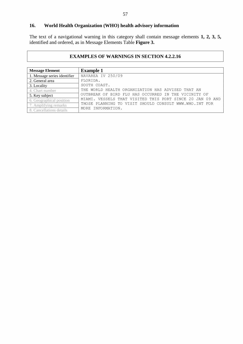
57
16. World Health Organization (WHO) health advisory information
The text of a navigational warning in this category shall contain message elements 1, 2, 3, 5,
identified and ordered, as in Message Elements Table Figure 3.
EXAMPLES OF WARNINGS IN SECTION 4.2.2.16
Message Element Example 1 1. Message series identifier NAVAREA IV 250/09
FLORIDA.
SOUTH COAST.
THE WORLD HEALTH ORGANIZATION HAS ADVISED THAT AN
OUTBREAK OF BIRD FLU HAS OCCURRED IN THE VICINITY OF
MIAMI. VESSELS THAT VISITED THIS PORT SINCE 20 JAN 09 AND
THOSE PLANNING TO VISIT SHOULD CONSULT WWW.WHO.INT FOR
MORE INFORMATION.
2. General area
3. Locality
4. Chart number
5. Key subject
6. Geographical position
7. Amplifying remarks
8. Cancellations details
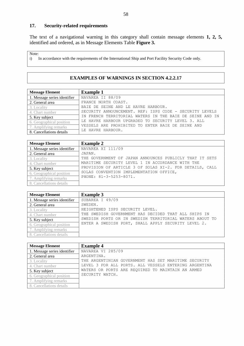
58
17. Security-related requirements
The text of a navigational warning in this category shall contain message elements 1, 2, 5,
identified and ordered, as in Message Elements Table Figure 3.
Note:
i) In accordance with the requirements of the International Ship and Port Facility Security Code only.
EXAMPLES OF WARNINGS IN SECTION 4.2.2.17
Message Element Example 1 1. Message series identifier NAVAREA II 88/09
FRANCE NORTH COAST.
BAIE DE SEINE AND LE HAVRE HARBOUR.
SECURITY ANNOUNCEMENT. REF: ISPS CODE - SECURITY LEVELS
IN FRENCH TERRITORIAL WATERS IN THE BAIE DE SEINE AND IN
LE HAVRE HARBOUR UPGRADED TO SECURITY LEVEL 3. ALL
VESSELS ARE PROHIBITED TO ENTER BAIE DE SEINE AND
LE HAVRE HARBOUR.
2. General area
3. Locality
4. Chart number
5. Key subject
6. Geographical position
7. Amplifying remarks
8. Cancellations details
Message Element Example 2 1. Message series identifier NAVAREA XI 111/09
JAPAN.
THE GOVERNMENT OF JAPAN ANNOUNCES PUBLICLY THAT IT SETS
MARITIME SECURITY LEVEL 1 IN ACCORDANCE WITH THE
PROVISION OF ARTICLE 3 OF SOLAS XI-2. FOR DETAILS, CALL
SOLAS CONVENTION IMPLEMENTATION OFFICE,
PHONE: 81-3-5253-8071.
2. General area
3. Locality
4. Chart number
5. Key subject
6. Geographical position
7. Amplifying remarks
8. Cancellations details
Message Element Example 3 1. Message series identifier SUBAREA I 49/09
SWEDEN.
HEIGHTENED ISPS SECURITY LEVEL.
THE SWEDISH GOVERNMENT HAS DECIDED THAT ALL SHIPS IN
SWEDISH PORTS OR IN SWEDISH TERRITORIAL WATERS ABOUT TO
ENTER A SWEDISH PORT, SHALL APPLY SECURITY LEVEL 2.
2. General area
3. Locality
4. Chart number
5. Key subject
6. Geographical position
7. Amplifying remarks
8. Cancellations details
Message Element Example 4 1. Message series identifier NAVAREA VI 285/09
ARGENTINA.
THE ARGENTINIAN GOVERNMENT HAS SET MARITIME SECURITY
LEVEL 3 FOR ALL PORTS. ALL VESSELS ENTERING ARGENTINA
WATERS OR PORTS ARE REQUIRED TO MAINTAIN AN ARMED
SECURITY WATCH.
2. General area
3. Locality
4. Chart number
5. Key subject
6. Geographical position
7. Amplifying remarks
8. Cancellations details

59
BULLETINS
Message Element Example 1 1. Message series identifier NAVAREA I 120/09
1. NAVAREA I MESSAGES IN FORCE AT 091000 UTC MAY 09:
2005 SERIES: 402.
2008 SERIES: 019 035 050 247 251 279 293 329.
2009 SERIES: 075 078 089 090 096 099 101 102 108 117
118 119 120 121 124 125.
NOTES:
A. TEXTS OF NAVAREA ONE MESSAGES ARE PRINTED IN WEEKLY
EDITIONS OF NOTICES TO MARINERS.
B. NAVAREA ONE MESSAGES LESS THAN 42 DAYS OLD (075/09
ONWARD) ARE CURRENTLY INCLUDED ON RELEVANT SAFETYNET
AND/OR NAVTEX BROADCASTS.
2. CANCEL NAVAREA I 115/09.
2. General area
3. Locality
4. Chart number
5. Key subject
6. Geographical position
7. Amplifying remarks
8. Cancellations details
Message Element Example 2 1. Message series identifier NAVAREA VII 141/09
1. NAVAREA VII MESSAGES IN FORCE = 055, 060, 070, 072, 077, 078, 102, 104, 105, 111, 112, 113, 114, 126,
129, 137, 140 OF 2009.
2. MESSAGES RE-ISSUED AS NOTICES TO MARINERS = NIL. 3. MESSAGES ISSUED THIS WEEK = 140, 141 OF 2009. 4. MESSAGES CANCELLED THIS WEEK = 141 OF 2009. 5. CANCEL THIS MESSAGE.
2. General area
3. Locality
4. Chart number
5. Key subject
6. Geographical position
7. Amplifying remarks
8. Cancellations details
Message Element Example 3 1. Message series identifier NAVAREA II 265/09
NAVAREA II IN FORCE AT 02 SEP 09.
2008: 017 - 112 - 239 - 241 - 254 - 258 - 259 – 260 -
263 - 264 – 265.
1. ONLY THOSE LESS THAN 42 DAYS OLD ARE DAILY BROADCASTED ON SAFETYNET AT 1630 UTC.
2. NAVAREA II WARNINGS ARE PRINTED IN WEEKLY EDITIONS OF NOTICES TO MARINERS (SECTION 1.2).
2. General area
3. Locality
4. Chart number
5. Key subject
6. Geographical position
7. Amplifying remarks
8. Cancellations details
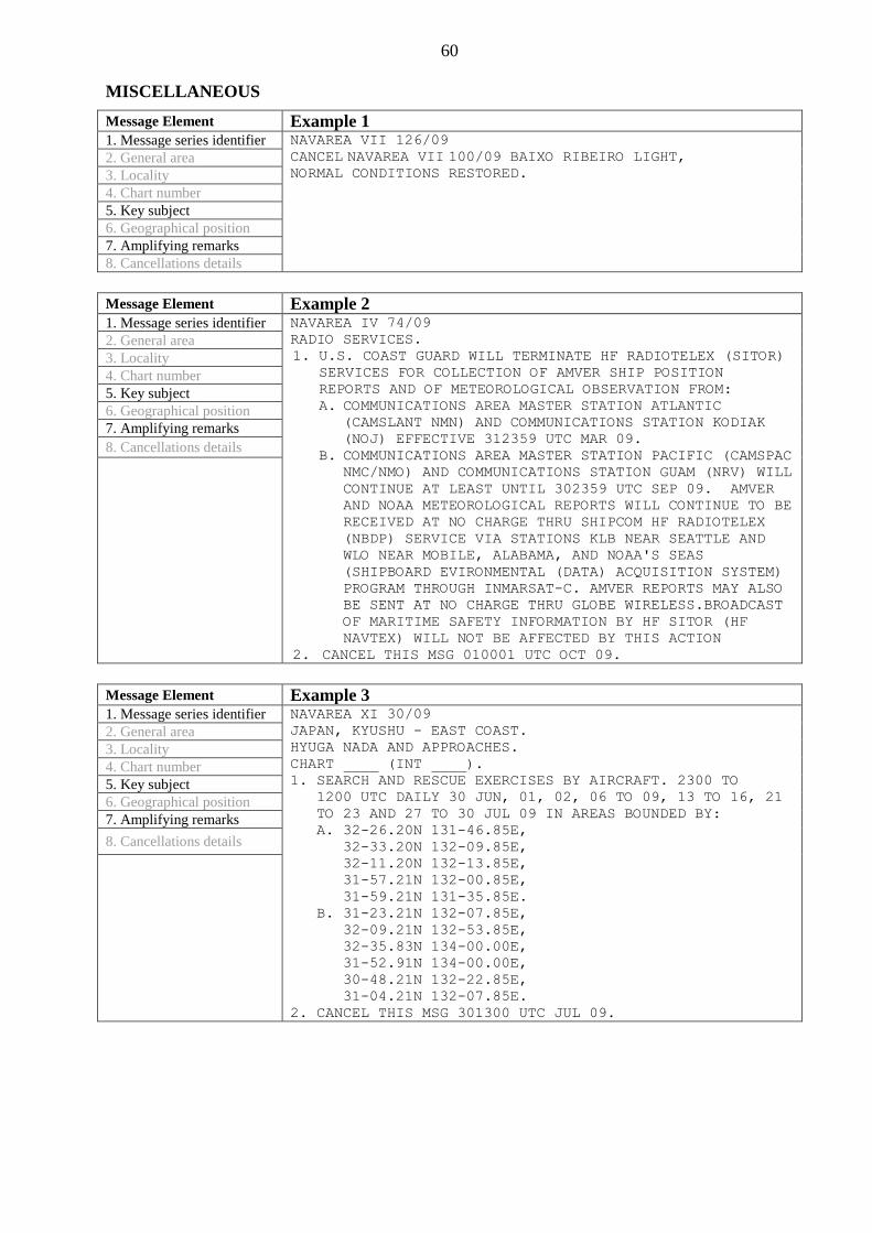
60
MISCELLANEOUS
Message Element Example 1 1. Message series identifier NAVAREA VII 126/09
CANCEL NAVAREA VII 100/09 BAIXO RIBEIRO LIGHT, NORMAL CONDITIONS RESTORED.
2. General area
3. Locality
4. Chart number
5. Key subject
6. Geographical position
7. Amplifying remarks
8. Cancellations details
Message Element Example 2 1. Message series identifier NAVAREA IV 74/09
RADIO SERVICES.
1. U.S. COAST GUARD WILL TERMINATE HF RADIOTELEX (SITOR) SERVICES FOR COLLECTION OF AMVER SHIP POSITION
REPORTS AND OF METEOROLOGICAL OBSERVATION FROM:
A. COMMUNICATIONS AREA MASTER STATION ATLANTIC
(CAMSLANT NMN) AND COMMUNICATIONS STATION KODIAK
(NOJ) EFFECTIVE 312359 UTC MAR 09.
B. COMMUNICATIONS AREA MASTER STATION PACIFIC (CAMSPAC
NMC/NMO) AND COMMUNICATIONS STATION GUAM (NRV) WILL
CONTINUE AT LEAST UNTIL 302359 UTC SEP 09. AMVER
AND NOAA METEOROLOGICAL REPORTS WILL CONTINUE TO BE
RECEIVED AT NO CHARGE THRU SHIPCOM HF RADIOTELEX
(NBDP) SERVICE VIA STATIONS KLB NEAR SEATTLE AND
WLO NEAR MOBILE, ALABAMA, AND NOAA'S SEAS
(SHIPBOARD EVIRONMENTAL (DATA) ACQUISITION SYSTEM)
PROGRAM THROUGH INMARSAT-C. AMVER REPORTS MAY ALSO
BE SENT AT NO CHARGE THRU GLOBE WIRELESS.BROADCAST
OF MARITIME SAFETY INFORMATION BY HF SITOR (HF
NAVTEX) WILL NOT BE AFFECTED BY THIS ACTION
2. CANCEL THIS MSG 010001 UTC OCT 09.
2. General area
3. Locality
4. Chart number
5. Key subject
6. Geographical position
7. Amplifying remarks
8. Cancellations details
Message Element Example 3 1. Message series identifier NAVAREA XI 30/09
JAPAN, KYUSHU - EAST COAST.
HYUGA NADA AND APPROACHES.
CHART ____ (INT ____).
1. SEARCH AND RESCUE EXERCISES BY AIRCRAFT. 2300 TO
1200 UTC DAILY 30 JUN, 01, 02, 06 TO 09, 13 TO 16, 21
TO 23 AND 27 TO 30 JUL 09 IN AREAS BOUNDED BY:
A. 32-26.20N 131-46.85E,
32-33.20N 132-09.85E,
32-11.20N 132-13.85E,
31-57.21N 132-00.85E,
31-59.21N 131-35.85E.
B. 31-23.21N 132-07.85E,
32-09.21N 132-53.85E,
32-35.83N 134-00.00E,
31-52.91N 134-00.00E,
30-48.21N 132-22.85E,
31-04.21N 132-07.85E.
2. CANCEL THIS MSG 301300 UTC JUL 09.
2. General area
3. Locality
4. Chart number
5. Key subject
6. Geographical position
7. Amplifying remarks
8. Cancellations details

61
Message Element Example 4 1. Message series identifier NAVAREA XV 55/09
DUE TO TIME CHANGE CARRIED OUT 300001 UTC MAR 09 CHILEAN
STANDARD TIME HAS CHANGED TO TIME ZONE (UTC+4). VESSELS
SHOULD COMPLY WITH REGULATIONS OF NATIONAL MARITIME
AUTHORITY IN THE FOLLOWING WEB SITE: WWW.SHOA.MIL.CL
(SERVICIOS/RADIOAVISOS/RADIOWARNINGS/PROVISIONS OF THE
NATIONAL MARITIME AUTHORITY). ALL VESSELS ARE REQUESTED
TO SEND IN CLEAR TEXT, WIND, SEA AND ATMOSPHERIC PRESSURE
REPORTS, TO CHILREP.
2. General area
3. Locality
4. Chart number
5. Key subject
6. Geographical position
7. Amplifying remarks
8. Cancellations details
ENC CONCERNS
Message Element Example 1. Message series identifier NAVAREA IV 89/09
GULF OF MEXICO.
NEW ORLEANS TO JACKSONVILLE.
DUE TO A PRODUCTION PROBLEM THAT HAS CAUSED DISPLACED
FEATURES, IT HAS BEEN DETERMINED THAT ELECTRONIC
NAUTICAL CHART US2GC12M (NEW ORLEANS TO JACKSONVILLE) IS
NOT TO BE USED FOR NAVIGATION OR SITUATIONAL AWARENESS.
A REVIEW IS IN PROCESS TO ADDRESS THIS SITUATION.
2. General area
3. Locality
4. Chart number
5. Key subject
6. Geographical position
7. Amplifying remarks
8. Cancellations details
AVOIDANCE OF CERTAIN FISHERIES AREAS
Message Element Example 1. Message series identifier NAVAREA III 445/09
LIGURIAN SEA.
1. FISHING OPERATIONS 031000 UTC THRU 152000 UTC AUG BY
F/V TRAWLER IN AREA BOUND BY:
A. 43-20N 009-27E.
B. 42-46N 008-40E.
C. 43-37N 008-40E.
D. 43-38N 007-53E.
E. 44-20N 008-53E.
F. 43-53N 009-27E.
WIDE BERTH REQUESTED.
2. CANCEL THIS MSG 152100 AUG 09.
2. General area
3. Locality
4. Chart number
5. Key subject
6. Geographical position
7. Amplifying remarks
8. Cancellations details
WEB SITE OUT OF SERVICE
Message Element Example 4 1. Message series identifier NAVAREA VIII 43/09
NAVAREA VIII WEBSITE.
1. NAVAREA VIII WEBSITE UNUSABLE
122300 UTC TO 132300 UTC NOV.
FOR URGENT SERVICE, CONTACT NAVAREA VIII,
PHONE: 91 135 274 7365,
FAX: 91 135 274 8373,
E-MAIL: [email protected].
2. CANCEL THIS MSG 140001 UTC NOV 09.
2. General area
3. Locality
4. Chart number
5. Key subject
6. Geographical position
7. Amplifying remarks
8. Cancellations details

62
8 – METEOROLOGICAL WARNINGS AND FORECASTS
8.1 Provision of warnings and weather and sea bulletins (GMDSS application)
8.1.1 The Global Maritime Distress and Safety System (GMDSS) application which is
compatible with and required by the radiocommunication provisions of the 1988 SOLAS
amendments via the NAVTEX, International SafetyNET and HF MSI services.
Principles
8.1.2 The principles for the preparation and issue of warnings and weather and sea bulletins are
as follows:
.1 For the purpose of the preparation and issue of meteorological warnings and the
regular preparation and issue of weather and sea bulletins, the oceans and seas are
divided into areas for which national Meteorological Services assume
responsibility.
.2 The areas of responsibility together provide complete coverage of oceans and seas
by meteorological information contained in warnings and weather and sea
bulletins.
.3 The issue of meteorological warnings and routine weather and sea bulletins for
areas not covered by NAVTEX shall be broadcast by the International SafetyNET
Service for the reception of maritime safety information (MSI) in compliance with
SOLAS chapter IV “Radiocommunications”, as amended.
Note: In addition, national Meteorological Services may have to prepare and/or issue
warnings and routine forecasts for transmission by an HF-direct printing
telegraphy maritime safety information service for areas where such a service is
provided for ships engaged exclusively on voyages in such areas.
.4 The preparation and issue of warnings and weather and sea bulletins for areas of
responsibility are coordinated in accordance with the procedures mentioned in the
Manual on Marine Meteorological Services (WMO No. 558) and the Guide to
Marine Meteorological Services (WMO No. 471), and summarized in the
following section.
.5 The efficiency and effectiveness of the provision of warnings and of weather and
sea bulletins are monitored by obtaining opinions and reports from marine users.
.6 Maritime Safety Information broadcasts are monitored by the originating Issuing
Service to ensure the accuracy and integrity of the broadcast.

63
8.2 Procedures
Definitions
8.2.1 A Preparation Service is a national Meteorological Service which has accepted
responsibility for the preparation of forecasts and warnings for parts of, or an entire, designated
Maritime Safety Information (MSI) area in the WMO system for the dissemination of
meteorological forecasts and warnings to shipping under the GMDSS and for their transfer to the
relevant Issuing Service for broadcast.
8.2.2 An Issuing Service is a national Meteorological Service which has accepted responsibility
for ensuring that meteorological forecasts and warnings for shipping are disseminated through
the Inmarsat and SafetyNET service to the designated area for which the Service has accepted
responsibility under the broadcast requirements of the GMDSS. The Issuing Service is
responsible for composing a complete broadcast bulletin on the basis of information input from
the relevant Preparation Services, and for inserting the appropriate EGC header, as specified in
annex 4(b) of the International SafetyNET Manual. The Issuing Service is also responsible for
monitoring the broadcasts of information to its designated area of responsibility.
Preparation and issue of weather and sea bulletins
8.2.3 Weather and sea bulletins shall include, in the order given hereafter:
.1 Part I: Storm warnings;
.2 Part II: Synopsis of major features of the surface weather chart and, to the
possible extent, significant characteristics of corresponding sea-surface
conditions; and
.3 Part III: Forecasts.
8.2.4 Weather and sea bulletins may, in addition, include the following parts:
.1 Part IV: Analysis and/or prognosis in IAC FLEET code form;
.2 Part V: Selection of reports from sea stations; and
.3 Part VI: Selection of reports from land stations.
Notes: (1) The reports included in part VI should be for a fixed selection of stations in a fixed
order.
(2) Parts IV, V and VI may be issued at a separate scheduled time.
8.2.5 For area(s) for which an Issuing Service has assumed responsibility, the Service should
select the appropriate CES to service that area. In particular, the following procedures should be
adopted:
.1 For scheduled broadcasts: These should be issued for broadcast over at least a
single nominated satellite, in accordance with a pre-arranged schedule,
coordinated by WMO.

64
.2 For unscheduled broadcasts: These should be issued for broadcast under the
SafetyNET Service through all Inmarsat ocean region satellites covering the
Issuing Service‟s area of responsibility.
8.2.6 Weather and sea bulletins shall be prepared and issued at least twice daily.
8.2.7 The issue of the weather and sea bulletins shall be at a scheduled time and be in the
following sequence: part I to be followed immediately by part II and then part III. A schedule of
transmission start times for these bulletins has been compiled for all MSI areas and the CESs
which serve the areas and takes into consideration, inter alia, the existing WMO synoptic times
for observations, data analysis and forecast production. Additionally, as these broadcast
schedules for the International SafetyNET Service have to be coordinated, under the aegis of
WMO, with other organizations such as IHO, Issuing Services should not independently change
or request WMO to arrange frequent alterations to these coordinated and published schedules.
8.2.8 Issuing Services must ensure that the correct EGC message addressing formats are
adhered to for all warning and forecast messages intended for broadcast by a CES.
8.2.9 Warnings shall be given in plain language. Synopses and forecasts should be given in
plain language, however some abbreviations may be used, especially when the size of the bulletin
needs to be reduced for dissemination by a low bandwidth system, such as the NAVTEX Service
(ref: 8.2.13).
8.2.10 Warnings, synopses and forecasts intended for the International SafetyNET and the
International NAVTEX Services shall be broadcast in English.
Note: Additionally, if a national Meteorological Service wishes to issue warnings and forecasts
to meet national obligations under SOLAS, broadcasts may be made in other languages.
These broadcasts will be part of national SafetyNET or NAVTEX Services.
8.2.11 In order to ensure the integrity of the warnings and forecasts being received by mariners,
it is essential that Issuing Services monitor the broadcasts which they originate. Monitoring is
especially important in a highly automated system which is dependent on careful adherence to
procedure and format. This may be accomplished by the installation of an EGC
receive-capability at the Issuing Service‟s facility.
Note: Each Issuing Service may use the EGC receiver to check the following:
(1) That the message has been broadcast;
(2) That the message is received correctly;
(3) That cancellation messages are properly executed; and
(4) Any unexplained delay in the message being broadcast.
8.2.12 The language of the synopsis should be as free as possible from technical phraseology.

65
8.2.13 The terminology in weather and sea bulletins should be in accordance with the
“Multilingual list of terms used in weather and sea bulletins”, which is available in Appendix I.2
to the Manual on Marine Meteorological Services (WMO No. 558) and in Annex 2.B to the
Guide to Marine Meteorological Services (WMO No. 471). Specific guidelines for the
NAVTEX Service, including a list of common abbreviations for weather and sea messages, are
available in Appendix II.2 to the Manual on Marine Meteorological Services (WMO No. 558).
The list of common abbreviations is also given in 8.6 hereto.
8.3 Warnings
8.3.1 Warnings shall be given for gales (Beaufort force 8 or 9) and storms (Beaufort force 10 or
over), and for tropical cyclones (hurricanes in the North Atlantic and eastern North Pacific,
typhoons in the Western Pacific, cyclones in the Indian Ocean and cyclones of similar nature in
other regions).
8.3.2 The issue of warnings for near gales (Beaufort force 7) is optional.
8.3.3 Warnings for gales, storms and tropical cyclones should have the following content and
order of items:
.1 type of warning;
.2 date and time of reference in UTC,
.3 type of disturbance (e.g., low, hurricane, etc.) with a statement of central pressure
in hectopascals;
.4 location of disturbance in terms of latitude and longitude or with reference to
well-known landmarks;
.5 direction and speed of movement of disturbance;
.6 extent of affected area;
.7 wind speed or force and direction in the affected areas;
.8 sea and swell conditions in the affected area; and
.9 other appropriate information such as future positions of disturbance.
Sub-items .1, .2, .4, .6, and .7 listed above shall always be included in the warnings.
8.3.4 When warnings are included for more than one pressure disturbance or system, the
systems shall be described in a descending order of threat.
8.3.5 Warnings shall be as brief as possible and, at the same time, clear and complete.
8.3.6 The time of the last location of each tropical cyclone or extra-tropical storm shall be
indicated in the warning.
8.3.7 A warning shall be issued immediately the need becomes apparent and broadcasted
immediately on receipt, followed by a repeat after six minutes, when issued as an unscheduled
broadcast.

66
8.3.8 When no warnings for gales, storms or tropical cyclones are to be issued, that fact shall be
positively stated in part I of each weather and sea bulletin.
8.3.9 Warnings shall be updated whenever necessary and then issued immediately.
8.3.10 Warnings shall remain in force until amended or cancelled.
8.3.11 Warnings issued as part I of a scheduled bulletin do not need to be repeated
after 6 minutes.
8.3.12 Warnings for other severe conditions such as poor visibility, severe sea states (such as
high swell, risk of abnormal waves, etc.), ice accretion, etc., shall also be issued, as necessary.
8.4 Synopses
8.4.1 The synopses given in part II of weather and sea bulletins shall have the following
content and order of items:
.1 date and time of reference in UTC;
.2 synopsis of major features of the surface weather chart; and
.3 direction and speed of movement of significant pressure systems and tropical
disturbances.
8.4.2 If possible, significant characteristics of corresponding wave conditions (sea and swell)
should be included in the synopsis as well as characteristics of other sea-surface conditions
(drifting ice, currents, etc.) if feasible and significant.
8.4.3 Significant low-pressure systems and tropical disturbances which affect or are expected to
affect the area within or near to the valid period of the forecast should be described; the central
pressure and/or intensity, location movement and changes of intensity should be given for each
system; significant fronts, high-pressure centres, troughs and ridges should be included whenever
this helps to clarify the weather situation.
8.4.4 Direction and speed of movement of significant pressure systems and tropical
disturbances should be indicated in compass points and metres per second or knots respectively.
8.4.5 Units used for speed of movement of systems shall be indicated.
67
8.5 Forecasts
8.5.1 The forecasts given in part III of weather and sea bulletins shall have the following
content and order of items:
.1 the valid period of forecast;
.2 name or designation of forecast area(s) within the main MSI area; and
.3 a description of:
(i) wind speed or force and direction;
(ii) sea state (significant wave height/total sea);
(iii) visibility when forecast is less than five nautical miles; and
(iv) ice accretion, where applicable.
8.5.2 The forecasts should include expected significant changes during the forecast period,
significant meteors such as freezing precipitation, snowfall or rainfall, and an outlook for a
period beyond 24 hours. In addition, phenomena such as breaking seas, cross seas, and abnormal
waves should also be included, where possible.
8.5.3 The valid period should be indicated either in terms of number of hours from the time of
issue of the forecast or in terms of dates and time in UTC of the beginning and the end of the
period.
8.5.4 The following descriptive terms should be used for visibility:
(i) very poor (less than 0.5 nautical miles)
(ii) poor (0.5 to 2 nautical miles)
(iii) moderate (2 to 5 nautical miles)
(iv) good (greater than 5 nautical miles)

68
8.6 Common abbreviations for International NAVTEX Service
Terminology in full NAVTEX
Abbreviation Terminology in full
NAVTEX
Abbreviation
North or Northerly N Slowly SLWY
Northeast or Northeasterly NE Quickly QCKY
East or Easterly E Rapidly RPDY
Southeast or Southeasterly SE Knots KT
South or Southerly S Km/h KMH
Southwest or Southwesterly SW Nautical miles NM
West or Westerly W Metres M
Northwest or Northwesterly NW HectoPascal HPA
Decreasing DECR Meteo… MET
Increasing INCR Forecast FCST
Variable VRB Further outlooks TEND
Becoming BECMG Visibility VIS
Locally LOC Slight SLGT or SLT
Moderate MOD Quadrant QUAD
Occasionally OCNL Possible POSS
Scattered SCT Probability/Probable PROB
Temporarily/Temporary TEMPO Significant SIG
Isolated ISOL No change NC
Frequent/Frequency FRQ No significant change NOSIG
Showers SHWRS or SH Following FLW
Cold Front C-FRONT or CFNT Next NXT
Warm Front W-FRONT or WFNT Heavy HVY
Occlusion Front O-FRONT or OFNT Severe SEV or SVR
Weakening WKN Strong STRG
Building BLDN From FM
Filling FLN Expected EXP
Deepening DPN Latitude/Longitude LAT/LONG
Intensifying/Intensify INTSF Filling FLN
Improving/Improve IMPR Deepening DPN
Stationary STNR Intensifying/Intensify INTSF
Quasi-Stationary QSTNR Improving/Improve IMPR
Moving/Move MOV or MVG Stationary STNR
Veering VEER Quasi-Stationary QSTNR
Backing BACK Moving/Move MOV or MVG

69
8.7 Delimitation of METAREAS
Figure 4 – METAREAs for coordinating and promulgating meteorological warnings and
forecasts within the GMDSS
The delimitation of such areas is not related to and shall not prejudice the delimitation of any
boundaries between States.

70
9 – SEARCH AND RESCUE NOTIFICATION
9.1 Communications related to search and rescue operations such as distress alerts,
coordination of operations, local communications and positioning signals are never MSI, even
when (for some shore-to-ship alerts) they use the International SafetyNET or NAVTEX services
which are also used for MSI. This guide, therefore, does not apply to them.
9.2 Search and Rescue operations may, however, involve the broadcasting of MSI in the
navigational warning category, described in 4.2.2.6.
10 – PROCEDURE FOR AMENDING THE JOINT IMO/IHO/WMO
MANUAL ON MSI
10.1 IHO Publication S-53, Manual on Maritime Safety Information mirrors the information in
the Joint IMO/IHO/WMO Manual on Maritime Safety Information, published by IMO.
10.2 Amendments to the Joint IMO/IHO/WMO Manual on Maritime Safety Information are
normally prepared / reviewed by IHO WWNWS, which includes representation from the IMO
Secretariat and WMO, prior to consideration by the IMO Sub-Committee on
Radiocommunications and Search and Rescue (COMSAR)
10.3 When preparing amendments to the Joint Manual WWNWS will also prepare the
appropriate amendments to S-53. The IHB will circulate both documents by Circular Letter to
IHO Member States for approval prior to their submission to IMO COMSAR.
10.4 The effective date for revisions to S-53 will be the same time as that for any revision to
the IMO published Joint IMO/IHO/WMO Manual on Maritime Safety Information.
___________