joint regional planning panel - the hills shire...comment: following the conciliation conference, a...
TRANSCRIPT

Joint Regional
Planning
Panel
Thursday, 20 October 2016
THE H
ILLS S
HIR
E C
OU
NC
IL

JOINT REGIONAL PLANNING PANEL 20 OCTOBER 2016
PAGE 2
ITEM SUBJECT PAGE
ITEM-1 JRPP REPORT - DA 913/2016/JP –
RESIDENTIAL FLAT BUILDING DEVELOPMENT –
LOTS 101 – 103 DP 1195876, NO. 2B AND LOT 103
HECTOR COURT AND LOT 102 AFFLECK CIRCUIT,
KELLYVILLE
3
ITEM-2 DA 1395/2016/JP –
DEMOLITION OF EXISTING STRUCTURES AND
CONSTRUCTION OF A MIXED USE DEVELOPMENT
CONTAINING 247 RESIDENTIAL UNITS, GROUND
FLOOR RETAIL, THREE (3) LEVELS OF
COMMERCIAL OFFICES AND FIVE (5) LEVELS OF
PARKING PROVIDING 646 CAR PARKING SPACES
– LOT 5074 DP 1003042, 11-13 SOLENT CIRCUIT,
BAULKHAM HILLS AND LOT 102 DP 1065520
61

JOINT REGIONAL PLANNING PANEL 20 OCTOBER 2016
PAGE 3
ITEM-1 JRPP REPORT - DA 913/2016/JP
(Sydney West)
JRPP No 2015SYW213
DA Number 913/2016/JP
Local Government
Area
THE HILLS SHIRE COUNCIL
Proposed
Development
RESIDENTIAL FLAT BUILDING DEVELOPMENT
Street Address LOTS 101 – 103 DP 1195876, NO. 2B AND LOT 103 HECTOR
COURT AND LOT 102 AFFLECK CIRCUIT, KELLYVILLE
Applicant DAVID KREPP
Number of
Submissions
First Notification: 34 submissions and a petition signed by an
additional 30 persons.
Second Notification: Nine
Regional
Development
Criteria
(Schedule 4A of
the Act)
CIV EXCEEDING $20 MILLION
List of All Relevant
s79C(1)(a) Matters
LEP 2012
DCP Part B Section 5 – Residential Flat Buildings
DCP Part D Section 7 – Balmoral Road release Area
SEPP 65 - Design Quality of Residential Flat Development
SEPP 32 – Urban Consolidation of Land
SEPP (State and Regional Development) 2011
SEPP Building Sustainability Index BASIX 2004
SEPP 55 - Remediation of Land
SREP 20 – Hawkesbury Nepean River
Does the DA
require Special
Infrastructure
Contributions
conditions
(s94EF)?
Yes, however the proposal is recommended for refusal.
List all documents
submitted with this
report for the
panel’s
consideration
All submissions

JOINT REGIONAL PLANNING PANEL 20 OCTOBER 2016
PAGE 4
Recommendation Refusal
Report by Principal Executive Planner
Kristine McKenzie
Report date 20 October 2016
Summary of S.79C matters
Have all recommendations in relation to relevant s79C matters been
summarised in the Executive Summary of the assessment report?
Yes
Legislative clauses requiring consent authority satisfaction
Have relevant clauses in all applicable environmental planning instruments
where the consent authority must be satisfied about a particular matter
been listed, and relevant recommendations summarised, in the Executive
Summary of the assessment report?
Yes
Clause 4.6 Exceptions to development standards
If a written request for a contravention to a development standard (clause
4.6 of the LEP) has been received, has it been attached to the assessment
report?
No, the
applicant
withdrew a
Clause 4.6
variation
request.
Conditions
Have draft conditions been provided to the applicant for comment?
No
EXECUTIVE SUMMARY
The Development Application is for an apartment building development containing 86
apartments. The development comprises three x five storey buildings containing 21 x 1
bedroom units, 58 x 2 bedroom units and 7 x 3 bedroom units. The site is a corner lot
and has frontage to Hector Court, Affleck Circuit and the future extension of Severn Vale
Drive. Two/three levels of basement parking are provided which contain parking for 186
vehicles comprising 151 resident spaces and 35 visitor spaces.
The site is zoned R4 High Density Residential under Local Environmental Plan (LEP) 2012
and apartment buildings are a permissible use in the zone. The site has a 16 metre
height limit under LEP 2012. The proposal has a maximum height of 16.4 metres which
is a variation of 2.5%. The applicant submitted a Clause 4.6 variation request with the
original plans at the time of lodgement of the Development Application however when
the applicant submitted the revised plans the Clause 4.6 variation request was
withdrawn on the basis that the applicant has sought to rely on Clause 5.6 of LEP 2012
which relates to architectural roof features. The proposed lift over-runs are not
considered to be an architectural roof feature and therefore a Clause 4.6 variation is
required. The proposal also exceeds the DCP height control which limits apartment
development to four storey. The proposal has height of five storeys.
The proposal also exceeds the DCP density requirement which is limited to a range of
150-175 persons per hectare. The proposed density is 288.21 persons per hectare. The
proposed density is considered unsatisfactory because it is not responsive to the
surrounding low density development.

JOINT REGIONAL PLANNING PANEL 20 OCTOBER 2016
PAGE 5
The application also includes a number of other variations to Council’s DCP in relation to
setbacks, Unit layout and design, urban design guidelines, unit layout and design, open
space and storage which are considered unsupportable in conjunction with the density
proposed. The development proposal results in a development that is considered to have
limited regard for the existing character of the locality, results in an unacceptable built
form and is an over-development of the site. In addition, the applicant has not
demonstrated that engineering, drainage and waste management can be adequately
addressed within the proposed design.
The proposal does not adequately address a number of matters under Section 79C of the
Environmental Planning and Assessment Act in relation to the above. The proposal is
however satisfactory in relation to SEPP 55 - Remediation of Land.
The proposal was notified on two occasions. During the first notification period, 34
submissions and a petition signed by an additional 30 persons were received, and during
the second notification period nine submissions were received. The issues raised in the
submissions relate to traffic, height, density, overdevelopment, bulk and scale,
streetscape and amenity impacts.
The application is recommended for refusal as it is an overdevelopment of the site which
would result in a greater number of units and persons on site than anticipated under
local planning controls and which is excessive and out of context with existing and future
character.
In the absence of the JRPP process, this matter would be determined by the
Development Assessment Unit.
BACKGROUND MANDATORY REQUIREMENTS
Owner: Hector Court Pty
Ltd and Fabcot Pty
Ltd
1. LEP 2012 – Unsatisfactory.
Zoning: R4 High Density
Residential
2. DCP Part B Section 5 – Residential
Flat Buildings - Unsatisfactory.
Area: 5829m2 3. SEPP 65 Design Quality of
Residential Flat Buildings –
Unsatisfactory.
Existing Development: Dwelling and
Ancillary Buildings
4. SEPP Building Sustainability Index
BASIX 2004 – Satisfactory
5. Section 79C (EP&A Act) –
Unsatisfactory.
6. Section 94 Contribution – Currently
$2,304,145.47
SUBMISSIONS REASON FOR REFERRAL TO JRPP
1. Exhibition: Yes, 14 days. 1. CIV exceeding $20 Million
2. Notice Adj Owners: Yes, 14 days.
3. Number Advised: 29
4. Submissions
Received:
First Notification:
34 submissions
and a petition
signed by an
additional 30
persons.
Second
Notification: Nine

JOINT REGIONAL PLANNING PANEL 20 OCTOBER 2016
PAGE 6
HISTORY
25/03/2014 Development Application 587/2014/ZE approved by the Development
Assessment Unit for an integrated housing development comprising 12
dwellings and associated Torrens Title subdivision of the dwellings and a
facilitating subdivision to create Lots 101 – 103. The proposed integrated
housing development was proposed on Lot 102.
10/12/2015
Subject Development Application lodged.
14/12/2015 Email sent to the applicant requesting owner’s consent from Fabcot Pty
Ltd (owner of Lot 103) given that Lot 103 is used to gain vehicle access
to the site.
19/02/2016 Letter sent to the applicant raising concern that the proposal is an
overdevelopment of the site given the number of variations proposed to
the DCP requirements, especially in regard to height and density and
advising that the proposal in its current form is unlikely to be supported.
The letter also requested the submission of owner’s consent, reduction in
height of the proposal in order to comply with the 16m LEP height limit,
DCP compliance, relationship, context and interface to adjoining land,
drainage and engineering matters, waste management, acoustic impact,
landscaping and street/unit numbering.
24/02/2016 Conciliation Conference held.
03/03/2016 Meeting held with the applicant and Council staff to discuss the issues
raised at the Conciliation Conference and the matters raised in the letter
to the applicant dated 19 February 2016. The applicant was advised that
the proposal is required to be amended to comply with height and
density controls.
08/04/2016 Meeting held with the applicant and Council staff to discuss the proposal.
The applicant tabled three options for discussion. These options were
reviewed by Council staff.
14/04/2016 Email sent to the applicant regarding the three options. The applicant
was advised that the proposal was required to be amended to comply
with the DCP density requirement, LEP height limit, DCP height limit and
DCP unit mix requirement. On the basis of compliance with these
matters, the applicant was advised that consideration could be given to e
reduced rear setback (adjoining the B2 Local Centre zoned land) and unit
sizes which are compliant with the ADG.
29/06/2016 Additional information submitted in response to the request for
additional/revised information dated 19 February 2016. This included the
reduction in units from 87 to 86 units.
12/07/2017 Amended/revised information notified to adjoining property owners and
those who made a submission to the original information.

JOINT REGIONAL PLANNING PANEL 20 OCTOBER 2016
PAGE 7
PROPOSAL
The proposal is for the demolition of the existing dwelling and structures and the
construction of a residential flat building development containing 86 apartments. The
development comprises three x five storey buildings containing 21 x 1 bedroom units, 58
x 2 bedroom units and 7 x 3 bedroom units.
The site is a corner lot and has frontage to Hector Court, Affleck Circuit and the future
extension of Severn Vale Drive. Two/three levels of basement parking are provided
which contain parking for 186 vehicles, comprising 151 resident spaces and 35 visitor
spaces. The vehicle access to the site is from a future extension of Severn Vale Drive
which will be a public road. Should approval have been recommended, the extension of
Severn Vale Drive would have been required to be constructed as part of the consent.
The proposed external materials include face brick and rendered walls.
CONCILIATION CONFERENCE
During the first notification period 34 submissions and a petition signed by an additional
30 persons were received. As a result, a Conciliation Conference was held on 24
February 2014.
The following outcomes were achieved:
a. Council staff will consider the issues raised during the Conference and this will
help inform their assessment.
Comment: All issues raised within the written submissions and raised at the Conciliation
Conference have been considered as part of the assessment of the Development
Application.
b. Council staff will require further information from the applicant and request that
they address concerns raised at the meeting regarding how the proposal relates
to surrounding development.
Comment: Following the Conciliation Conference, a meeting was held with the applicant
to discuss the issues raised at the Conciliation Conference and matters raised in Council’s
letter to the applicant dated 19 February 2016.
c. Council’s Traffic team will be requested to review:
- Need for the closure of Hector Court and the opening of the Severn Vale Drive
extension.
Comment: The closure of Hector Court and the signalisation of the intersection of
Severn Vale Drive and Memorial Avenue has been identified within the DCP as required
local road upgrade works in order to improve traffic safety and improve traffic function
and a clear road hierarchy. The closure of Hector Court is dependent on the development
of adjoining parcels to the north of the subject site and the upgrade of Memorial Avenue
by RMS.
- Changes in traffic flow around the area.
Comment: The revised road hierarchy and associated closures and road openings will
result in changes to traffic flow in the area. It is acknowledged that this will alter the
existing traffic arrangements on some roads, however these changes have been
identified within the DCP and will lead to improved traffic safety and flow.
- Traffic improvements/upgrades in the area.

JOINT REGIONAL PLANNING PANEL 20 OCTOBER 2016
PAGE 8
Comment:
The Balmoral Road Release Area DCP identifies where traffic improvements are to be
implemented. In broad terms the key changes within the immediate area are:
The closure of Hector Court;
Construction of an extension of Severn Vale Drive to Memorial Avenue and the
signalisation of the intersection.
Upgrade of Memorial Avenue (work to be undertaken by RMS) to four lanes.
Closure of Fairway Drive (at the future extension of Stone Mason Drive) to
prohibit access to Windsor Road; and
The construction of new local roads as part of on-going subdivision of the area.
- Increase in traffic in the area due to the new railway stations.
Comment:
The Sydney Metro North West rail link includes three stations in close proximity to the
site, being Norwest Station, Bella Vista Station and Kellyville Station. The closest station
to the site will be Norwest Station which is approximately 2.4 kilometres from the site.
The traffic generated by the railway station precincts has been considered in the traffic
report commissioned by Transport for NSW as part of the overall structure plans. The
opening of the rail link will change traffic flow in the area and will reduce commuter road
trips. Kellyville and Bella Vista Stations will attract commuters as they will have parking
stations which will likely generate additional traffic on Memorial Avenue hence the need
for the four lane upgrade works.
- Consideration of future sporting complexes and shopping centres.
Comment:
The location of future recreation and retail space has been considered as part of the
planning process associated with the preparation of the DCP. As part of this review,
traffic impacts have been considered which in part has contributed to the need for local
road improvements such as traffic lights at Severn Vale Road/Memorial Road intersection
and the Wrights Road/Windsor Road intersection.
- Confirmation of bus routes in the area.
Comment:
Hillsbus will determine the bus routes in the area to satisfy their contractual obligations
to Transport for NSW. Route services will operate on Fairway Drive, Severn Vale Drive
and Free Settlers Drive, and T-Way services will operate along Memorial Road.
- Accident history on Memorial Avenue.
Comment: A number of accidents have occurred on Memorial Road in the past,
generally at intersections. The road upgrade works and signalised intersections will assist
in reducing accidents and will improve road safety.
- Relocation of the rail stations in the area.
Comment:
The location of railway stations has been determined by the State Government.
JOINT REGIONAL PLANNING PANEL 20 OCTOBER 2016
PAGE 9
ISSUES FOR CONSIDERATION
1. SEPP State and Regional Development 2011
Clause 20 of SEPP (State and Regional Development) 2011 and the Schedule 4A of the
Environmental Planning and Assessment Act, 1979 provides the following referral
requirements to a Joint Regional Planning Panel:-
Development that has a capital investment value of more than $20 million.
The proposed development has a capital investment value of $23,308,020 thereby
requiring referral to, and determination by, a Joint Regional Planning Panel. In
accordance with this requirement the application was referred to, and listed with, the
JRPP for determination.
2. Compliance with LEP 2012
a. Background to the Zoning
The zoning of the area known as the Balmoral Road Release Area was originally zoned as
Rural 1(a) under LEP 1991. In 2003 and 2004 Council considered the rezoning of the
Balmoral Road Release Area and in September 2004 Council resolved to prepare a draft
Local Environmental Plan (LEP) and Development Control Plan (DCP). The draft LEP
proposed that the subject site be zoned Residential 2(a1) which allowed apartment
buildings. Amendment No. 5 of LEP 2005 came into force in April 2006 and the site was
rezoned to Residential 2(a1).
In March 2006 the NSW Government directed all Councils within the State to prepare a
new LEP based on a standard template. This included a translation of zones from the old
naming system to the new naming system. The zoning of the site then became R4 High
Density Residential under LEP 2012. Apartment buildings continued to be a permissible
use in the R4 High Density Residential.
b. Permissibility
The site is zoned R4 High Density Residential under LEP 2012. The proposal is defined as
a residential flat building development as follows:
residential flat building means a building containing 3 or more dwellings, but does not
include an attached dwelling or multi dwelling housing.
A residential flat building is a permissible use within the R4 High Density Residential
zone.
c. Zone Objectives
The objectives of the R4 High Density Residential zone are:
To provide for the housing needs of the community within a high density
residential environment.
To provide a variety of housing types within a high density residential
environment.

JOINT REGIONAL PLANNING PANEL 20 OCTOBER 2016
PAGE 10
To enable other land uses that provide facilities or services to meet the day to
day needs of residents.
To encourage high density residential development in locations that are close to
population centres and public transport routes.
Comment:
It is considered that the proposed development is not necessarily inconsistent with the
zone objectives however concern is raised that the proposal does not meet the intent of
the R4 High Density Residential zone given the density proposed.
d. LEP Standards
The LEP limits height on this site to 16 metres. The original proposal sought to exceed
the LEP height standard to a maximum height of 17 metres to the top of the lifts. The
proposal has since been amended and the following heights apply:
Building Maximum Height to Roof Maximum Height to Top of Lifts
Building 1 13.2 – 16m 13.8 – 16.4m
Building 2 15.4 – 16m 16.3m
Building 3 15.8 – 16m 15.9 – 16.2m
The applicant has advised as follows:
The plans have been amended to ensure the buildings are fully compliant with the
maximum height permitted of 16 metres under The Hills LEP 2012.
The submitted Clause 4.6 is therefore withdrawn.
The footprint of the units on the upper level has been reduced and one unit on the upper
level of building 1 has been removed. As amended the height to the roof of all buildings
is compliant with the maximum height permitted under the LEP. The lift overrun to each
Building results in a minor variation of between 200 to 400mm above the height control.
However, as discussed in detail in the submitted SEE, the lifts are designed as
architectural roof features that are a key component of the design of the building. The
lift overruns are a continuation of the external façade and result in a linear vertical
element that rises up the building. The lift overruns are an extension from the ground
level to the top of the building and provide a striking vertical expression on the facades.
The lift overruns are finished in rendered masonry that assists in the forms breaking the
length of the buildings.
As amended the proposed buildings are fully compliant with the maximum building
height permitted.
It is noted that the DCP also limits the height to four storeys. The proposal has a height
of five storey.
Comment:
LEP 2012 limits the height for the site to 16 metres. The proposed height is a maximum
16.4 metres to the top of the lift. This represents a maximum 2.5% variation to the LEP
standard. Attachment 6 shows the LEP height limit in relation to the buildings.

JOINT REGIONAL PLANNING PANEL 20 OCTOBER 2016
PAGE 11
The objectives of Clause 4.3 are as follows:
(a) to ensure the height of buildings is compatible with that of adjoining development
and the overall streetscape.
(b) to minimise the impact of overshadowing, visual impact, and loss of privacy on
adjoining properties and open space areas.
The objectives of Clause 4.6 of LEP 2012 are:
(a) to provide an appropriate degree of flexibility in applying certain development
standards to particular development,
(b) to achieve better outcomes for and from development by allowing flexibility in
particular circumstances.
The objectives of the R4 High Density Residential zone are:
To provide for the housing needs of the community within a high density
residential environment.
To provide a variety of housing types within a high density residential
environment.
To enable other land uses that provide facilities or services to meet the day to
day needs of residents.
To encourage high density residential development in locations that are close to
population centres and public transport routes.
Clause 5.6 of LEP 2012 states:
5.6 Architectural roof features
(1) The objectives of this clause are as follows:
(a) to allow architectural roof features that will integrate with building composition
and form and encourage a high quality built form.
(2) Development that includes an architectural roof feature that exceeds, or causes a
building to exceed, the height limits set by clause 4.3 may be carried out, but
only with development consent.
(3) Development consent must not be granted to any such development unless the
consent authority is satisfied that:
(a) the architectural roof feature:
(i) comprises a decorative element on the uppermost portion of a building,
and
(ii) is not an advertising structure, and
(iii) does not include floor space area and is not reasonably capable of
modification to include floor space area, and
(iv) will cause minimal overshadowing, and
(b) any building identification signage or equipment for servicing the building (such
as plant, lift motor rooms, fire stairs and the like) contained in or supported by
the roof feature is fully integrated into the design of the roof feature.

JOINT REGIONAL PLANNING PANEL 20 OCTOBER 2016
PAGE 12
The proposed variation to the building height is not considered to be an architectural
design feature and as such a Clause 4.6 variation is required. The proposal is considered
to be unsatisfactory and cannot be determined in a positive manner given the non-
provision of the Clause 4.6 variation request.
The proposed lift over-runs are a clear feature of the roof line. The lift over-runs do not
add to the architectural design of the roof and do not result in a high quality built form.
As such the proposal is considered to be unsatisfactory in regard to the objective of the
clause.
In regard to height, it is also noted that the DCP limits apartment development to four
storey in nature. The proposed additional storey has added to the bulk and scale of the
development. In addition, the density of the proposal adds to the scale of the
development and has resulted in an over-development of the site.
The proposal is considered unsatisfactory in regard to the objectives of Clause 4.3 of LEP
2012 as the height of the buildings is not compatible with the adjoining development or
the streetscape. In this regard the land to the south and west has been developed for
two storey residential dwellings which reflect the low density nature of the area.
Whilst it is acknowledged that the site is zoned R4 High Density Residential and the
proposed use is permissible, the proposed height does not adequately consider the
adjoining low density single residential development to the west and south which
generally comprises two storey detached dwellings. The proposed five storey design is
out of character with the existing surrounding development and does not adequately
address the interface.
On the basis of the height above the LEP limit, the non-provision of a Clause 4.6
variation and the proposed number of storeys, the development is considered
unsatisfactory.
3. SEPP 55 – Remediation of Land
Clause 7 (Contamination and remediation to be considered in determining development
application) of SEPP 55 – Remediation of Land states:
(1) A consent authority must not consent to the carrying out of any development on
land unless:
(a) it has considered whether the land is contaminated, and
(b) if the land is contaminated, it is satisfied that the land is suitable in its
contaminated state (or will be suitable, after remediation) for the purpose
for which the development is proposed to be carried out, and
(c) if the land requires remediation to be made suitable for the purpose for
which the development is proposed to be carried out, it is satisfied that
the land will be remediated before the land is used for that purpose.
The applicant has submitted a Preliminary Site Investigation report by Trace
Environmental which has concluded that:
Based on the results of the PSI, there is considered to be a low potential for
contamination to be present at the site as a result of the current and historic land uses
of the property, and the site is therefore considered suitable for the proposed medium
density residential redevelopment. In view of this, a Detailed Site Investigation (DSI) is
not considered necessary prior to the proposed residential redevelopment of the site.

JOINT REGIONAL PLANNING PANEL 20 OCTOBER 2016
PAGE 13
In the event that soil is excavated and requires off-site disposal during redevelopment,
the soil should be tested and classified in accordance with NSW EPA guidelines prior to
off-site disposal. Any imported material brought onto the site, to achieve construction
levels or for landscaping purposes, must be validated as being suitable for the proposed
medium density residential land use.
As such not objection is raised to the proposal on the basis of site contamination.
4. Compliance with DCP Part B Section 5 – Residential Flat Buildings
The following table details the proposal’s compliance with the DCP:
DEVELOPMEN
T STANDARD
(CLAUSE NO.)
DCP REQUIREMENTS PROPOSED
DEVELOPMENT
COMPLIANCE
1.1 Permissible
Zones
R1 General Residential, R4 High
Density Residential, B2 Local
Centre, B4 Mixed Use
The subject site
is zoned R4 High
Density
Residential and
the proposal is a
permissible use.
Yes
3.1 Site
Requirements
The minimum lot size for
residential flat buildings is
specified in Clause 4.1A of The
Hills Local Environmental Plan
2012, as follows:
Within:
R1 General Residential – 4,000m2
R4 High Density Residential –
4,000m2
B2 Local Centre – 4,000m2
B4 Mixed use – 4,000m2
Min. road frontage – 30m
A residential flat building shall
not isolate adjoining lots so that
they are incapable of multi
dwelling housing development,
meaning there will be sufficient
area to meet the minimum site
area requirement in Clause 4.1A
Minimum lot sizes for dual
occupancy, multi dwelling
housing and residential flat
buildings of the LEP 2012.
5829m2 (Lots
101 and 102 only
– this area does
not include the
temporary
access over Lot
103).
The site has a
frontage of
50.53m to
Hector Court and
207.61m to
Affleck Circuit.
The proposal
does not isolate
any adjoining
sites.
Yes
3.3 Setbacks –
Building Zones
Where trees are located within
the 10 front setback, 8m rear
setback and 6m side setback, the
building zone boundaries will be
set so that all buildings are 5m
from the trees or clear of the drip
line of the trees whichever is the
greater distance.
There are no
significant trees
that are worthy
of retention.
No – see
comments
below.

JOINT REGIONAL PLANNING PANEL 20 OCTOBER 2016
PAGE 14
Front (one street frontage) - 10m
Front (two street frontages):
Primary frontage – 10m
Secondary frontage – 6m
Side – 6m
Rear – 8m
Affleck Circuit is
considered to be
the primary
frontage as it is
the longest
frontage. The
site has three
street frontages,
including the
frontage to
Severn Vale
Road (not yet
constructed).
Hector Court –
6m setback
required –
variations
proposed to the
courtyards into
the setback.
Affleck Circuit –
10m setback
required –
encroachments
are proposed
including to the
fire stairs, entry
area and
courtyards into
the setback.
Severn Vale
Road – 6m
setback required
– variations
proposed to the
courtyards into
the setback.
Rear setback (to
northern
boundary – 8m
required -
variations
proposed to the
balconies into
the setback.

JOINT REGIONAL PLANNING PANEL 20 OCTOBER 2016
PAGE 15
3.4 Building
Heights
Refer to building height maps of
The Hills Local Environmental
Plan 2012.
No buildings shall contain more
than 4 storeys above natural
ground level.
See comments
above in regard
to LEP height.
The proposed
buildings are five
storeys in height.
No – see
comments
below.
3.5 Building
Separation and
Treatment
12m Minimum 12m
separation.
Yes
3.6 Landscaped
Area
50% of site area
The site is
5829m2 and 50%
of the site is
2914.5m2. There
is 3712m2 of
landscape works
proposed which
is 64%.
Yes
3.7 Building
Length
Max. 50m
The following
buildings lengths
are proposed:
Building 1 – 50m
Building 2 –
41.5m
Building 3 – 50m
Yes
3.8 Building
Design and
Streetscape
Must refer to Council’s “Multi-Unit
Housing: Urban Design
Guidelines 2002”
Designs must be in harmony in
terms of form, mass, colour and
structure with existing and likely
future development in the street.
Siting and design to ensure clear
definition of street edge and
reinforce street corners. Building
lines together with landscaping
treatments should distinguish the
public and private realms.
Must not be repetitive in design
and incorporate harmonious
design variations such as
verandas, entrances, facades,
etc.
Walls and Rooflines:
- Articulation provided to reduce
bulk
- With variety of colours to
reduce monotony and add
enhance the streetscape
The proposal is
considered to be
unsatisfactory in
regard to its
design and
character. The
proposed five
storey
development
does not respond
to the existing
low density
character of the
area and is not in
keeping with the
desired scale and
mass of
development.
The proposal
does not reflect
the existing scale
of development
in the area and
does not respond
to the interface
between the two
forms of
development.
No

JOINT REGIONAL PLANNING PANEL 20 OCTOBER 2016
PAGE 16
- With windows to enhance
façade appearance
- Well balanced vertical and
horizontal proportions
- Break up large horizontal
facades (whether walls or
roofs) into smaller sections no
longer than 10m
- Use of well-proportioned and
balanced projections and
recesses on facades.
- Provision of architectural
features in the façade such as
entry porches, pergolas, etc.
Garages:
- Comprise more than one
material and colour to enhance
visual attractiveness and
interest.
- Concealed or screened by
planting from the street and
public view, as much as
possible.
Entrances:
- Clearly visible from the public
and semi-public areas. Lighting
to be provided for safety at
night.
- Entries to be readily apparent
from the street and clearly
visible from inside the dwelling
for casual surveillance.
- Space around building
entrance to be sufficiently
large to stand out and have a
distinctive architectural form.
- Entries to be distinctive,
attractive and welcoming.
- Provide sheltered transitional
areas around building entries.
- All ground floor dwellings to
have their own entry at ground
level.
- Building entries to be visible
from, or address the site front
boundary, and clearly
delineated and observable
from the driveway.
Views and Siting:
- Siting of building to take
advantage of any views to
nearby/adjoining landscaped
open space or any public
reserve.

JOINT REGIONAL PLANNING PANEL 20 OCTOBER 2016
PAGE 17
- Siting and design to take
advantage of any views to
open space, public reserves
and bushland to promote
natural surveillance and
enhance visual amenity for
residents.
- Avoid blank courtyard walls
along boundaries shared with
open space or reserves.
- Provide opportunities to create
and orient dwellings to permit
direct views from living areas
into the open space/reserve.
- Avoid courtyards facing a
street or public place. If cannot
be avoided due to design
constraints, design to comply
with Section 3.27 Fencing
giving consideration to
streetscape and visual impact
issues.
3.9 Urban
Design
Guidelines
Demonstrate conformity with
“Baulkham Hills Multi Unit
Housing – Urban Design
Guidelines 2002"
The proposal is
considered to be
unsatisfactory in
regard to its
design and
character. The
proposed five
storey
development
does not respond
to the existing
low density
character of the
area and is not in
keeping with the
desired scale and
mass of
development.
The proposal
does not reflect
the existing scale
of development
in the area and
does not respond
to the interface
between the two
forms of
development.
No
3.10 Density 150-175 persons per hectare
The proposed
density is
288.21ppha.
No – see
comments
below.

JOINT REGIONAL PLANNING PANEL 20 OCTOBER 2016
PAGE 18
3.11 Unit
Layout and
Design
Apartment Mix
(a) No more than 25% of the
dwelling yield is to comprise
either studio or one bedroom
apartments.
(b) No less than 10% of the
dwelling yield is to comprise
apartments with three or more
bedrooms.
Residential Flat Development (30
or more units) (d) The minimum
internal floor area for each unit,
excluding common passageways,
car parking spaces and balconies
shall not be less than the
following:
Type 1 apartments shall not
exceed 30% of the total number
of 1, 2 and 3 bedroom
apartments.
Type 2 apartments shall not
exceed 30% of the total number
of 1, 2 and 3 bedroom
apartments.
All remaining apartments are to
comply with the Type 3
apartment sizes.
The proposal
does not meet
the unit size, mix
and type
requirements.
There are 24.4%
one bedroom
units and 8.1%
three bedroom
units.
Proposed Unit
Sizes are:
1 bedroom Type
1 – 50-56m2
2 bedroom Type
1 – 75-86m2
3 bedroom Type
1 – 95-107m2
All units
proposed are
Type 1 units.
No – see
comments
below.

JOINT REGIONAL PLANNING PANEL 20 OCTOBER 2016
PAGE 19
3.12 Building
Materials
Must comply with the Local
Government Act, 1993, Local
Government regulations and
Building Code of Australia
Reflect and complement the
existing character and
streetscape.
Choice of materials to consider
both their environmental and
economic costs.
Use graffiti resistant materials in
areas accessible by the general
public and communal areas
within the development.
Use colours that are visually
pleasing and reflect the
predominant colours in the area.
Avoid materials and colours with
excessive glare.
Avoid materials that are likely to
contribute to poor internal air
quality.
Select materials that will
minimise the long-term
environmental impact over the
whole life of the development.
Preference to materials derived
from renewable sources or are
sustainable and generate lower
environmental cost, recycled
material/s with low embodied
energy, better lifecycle costs and
durability.
The proposed
building
materials are
satisfactory and
are appropriate
for the form of
development.
Yes
3.13 Open
Space
Private:
Ground level – 4m x 3m (min)
Above ground – min. 10m2 with
min. depth 2.5m
Common: 20m2 per dwelling
All of the ground
floor units
exceed 12m2 and
have appropriate
dimensions.
Variations are
proposed to:
Block 1 – 108,
208 and 308 (all
9m2).
Block 2 – 111,
211 and 311 (all
8m2).
No – see
comments
below.
JOINT REGIONAL PLANNING PANEL 20 OCTOBER 2016
PAGE 20
Block 3 – 115,
215 and 315 (all
8m2).
Based on 86
units, a common
open space area
of 1720m2 is
required. An area
of 1750m2 is
provided.
3.14 Solar
Access
Adjoining buildings / open space
areas – 4 hours between 9am
and 3pm on 21 June
Common open space – 4 hours
between 9am and 3pm on 21
June
Adequate solar
access is
provided to the
common open
space area.
Yes
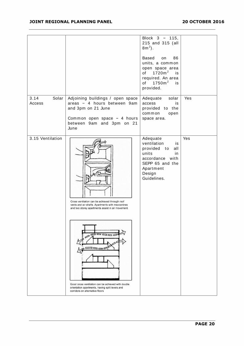
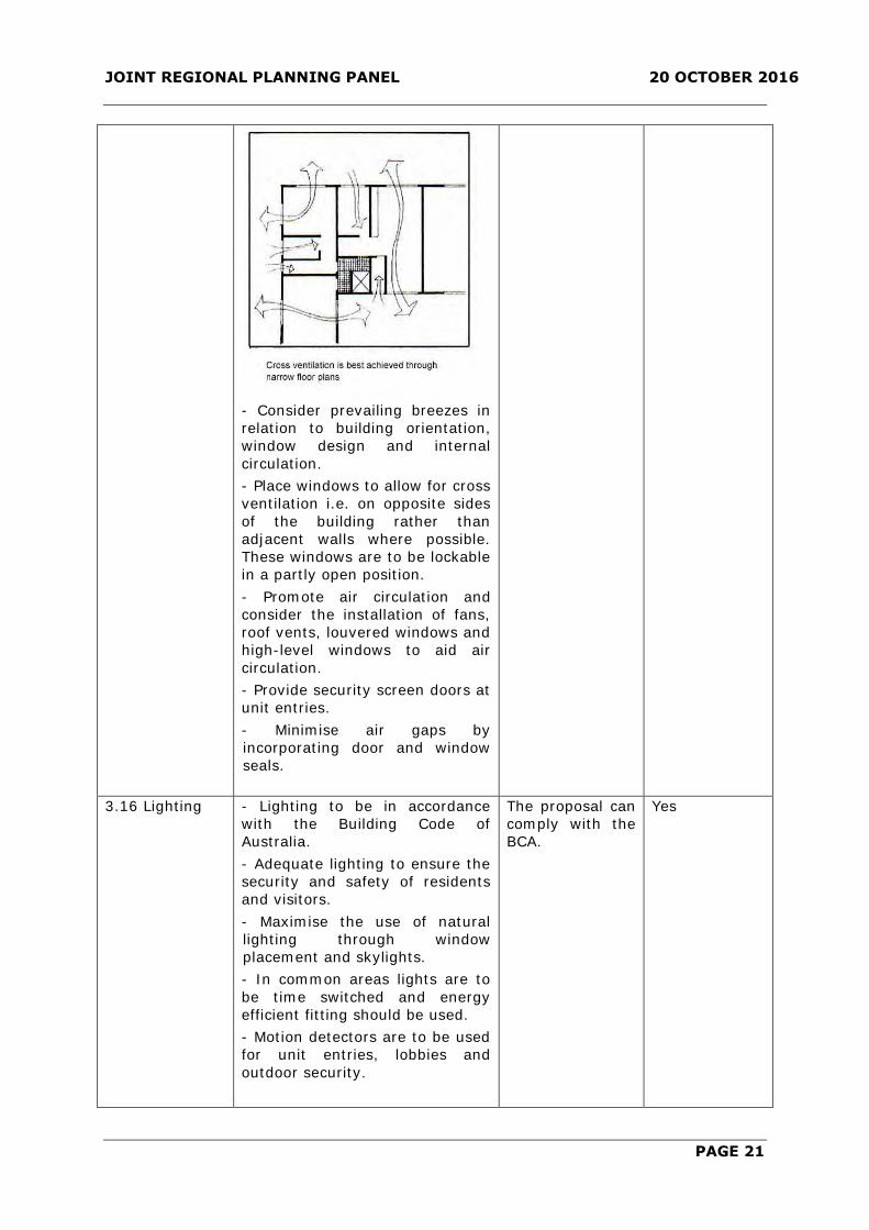
3.15 Ventilation
Adequate
ventilation is
provided to all
units in
accordance with
SEPP 65 and the
Apartment
Design
Guidelines.
Yes
JOINT REGIONAL PLANNING PANEL 20 OCTOBER 2016
PAGE 21
- Consider prevailing breezes in
relation to building orientation,
window design and internal
circulation.
- Place windows to allow for cross
ventilation i.e. on opposite sides
of the building rather than
adjacent walls where possible.
These windows are to be lockable
in a partly open position.
- Promote air circulation and
consider the installation of fans,
roof vents, louvered windows and
high-level windows to aid air
circulation.
- Provide security screen doors at
unit entries.
- Minimise air gaps by
incorporating door and window
seals.
3.16 Lighting - Lighting to be in accordance
with the Building Code of
Australia.
- Adequate lighting to ensure the
security and safety of residents
and visitors.
- Maximise the use of natural
lighting through window
placement and skylights.
- In common areas lights are to
be time switched and energy
efficient fitting should be used.
- Motion detectors are to be used
for unit entries, lobbies and
outdoor security.
The proposal can
comply with the
BCA.
Yes
JOINT REGIONAL PLANNING PANEL 20 OCTOBER 2016
PAGE 22
- Incorporate dimmers, motion
detectors, and automatic turn-off
switches where appropriate.
- Provide separate switches for
special purpose lights.
3.17
Stormwater
Management
- Drainage easements required
where the development property
does not drain directly into the
existing stormwater drainage
system or a public road.
Development Consent will not be
issued until the submission of
documents demonstrating the
creation of any necessary
easements over downstream
properties.
- Discharge points are to be
controlled and treated to prevent
soil erosion, and may require
energy dissipating devices on
steeper topography, to Council’s
requirements.
- Where necessary, downstream
amplification of existing drainage
facilities will be required
including Council infrastructure if
required.
- Developments within the Upper
Parramatta River Catchment
must comply with any
requirements of the Sydney
Catchment Management
Authority.
- On-site detention, water
recycling, or water quality
management systems may be
required to Council’s and/or the
Sydney Catchment Management
Authority and/or the Hawkesbury
Catchment requirements, to
counteract an increase in
stormwater runoff.
-Design of drainage systems to
be in accordance with Council’s
Design Guidelines for
Subdivisions/ Developments.
- Water Sensitive Urban Design
(WSUD) principles to be
employed in the management of
the site’s stormwater in terms of
water retention, reuse and
cleansing. In this regard, the
drainage design is to include
Council’s
Engineers have
raised concerns
with the
proposal.
No – see
comments
below.

JOINT REGIONAL PLANNING PANEL 20 OCTOBER 2016
PAGE 23
measures to manage the water
quality of stormwater runoff. At a
minimum the design is to
integrate bio-retention filters
along roadways, driveways and
within open space areas;
- On site detention tanks are only
permitted in common areas
within a proposed development
(for example driveways, common
open space) and not within
private courtyards.
3.18 Vehicular
Access
- Access to the site to be in
accordance with the
requirements of The Hills DCP
Part C Section 1 – Parking.
- Provision of adequate vehicular
entry and exit and circulation
areas. The design must:
- provide a safe environment
for both pedestrians and
vehicles using the site and
surrounding road networks;
- ensure vehicular ingress and
egress to the site is in a
forward direction at all times;
- provide for service vehicles
where possible; and
- be designed to minimise the
visual impact of hard paved
areas.
- A centrally located driveway, a
minimum of 10 metres from any
side boundary or street.
- Minimum driveway width of 6
metres at the property boundary
for a distance of 6 metres within
the development to ensure easy
entry/exit of vehicles.
- Driveway gradients to be in
accordance with Australian
Standard – AS 2890.1 – 1993 –
Part 1 – Parking Facilities – Off
Street Car Parking.
Council’s
Engineers have
raised concerns
with the
proposal.
The proposed
driveway access
is not centrally
located and has
a setback from
the northern
boundary of
approximately
350mm.
No – see
comments
below.

JOINT REGIONAL PLANNING PANEL 20 OCTOBER 2016
PAGE 24
3.19 Car
parking
Rate per unit & visitor parking:
1 space per 1 bedroom unit
2 spaces per 2 or 3 bedroom unit
Visitor – 2 spaces per 5 dwellings
Parking Dimension:
- Lockable single garages min.
dimension – 5.5 metres x 3
metres (exclusive of storage)
- Lockable double garages min.
dimension – 5.5 metres x 5.4
metres (exclusive of storage)
- Visitor parking dimensions –
5.5 metres x 2.6 metres
Manoeuvring and Ramps:
- First 6 metres of the driveway
inside the property boundary to
be a maximum of 5%
- Ramp grades to comply with
Australian Standard 2890.1
- Manoeuvring in accordance with
Australian Standard 2890.1
Based on:
21 x 1 bedroom
@ 1 space = 21
67 x 2/3
bedroom @ 2
spaces = 130
spaces
151 resident
spaces required.
Based on 86
units, 35 (34.4)
visitor spaces are
required.
Total: 186
spaces required.
There are 186
spaces provided
which comprise
151 residential
spaces and 35
visitor spaces.
This includes 5
accessible
resident spaces
and 1 accessible
visitor space.
The carparking
layout will be
required to
comply with the
Australian
Standards.
There are no
stacked spaces
proposed.
One carwash bay
is also provided
within a visitor
parking space,
and four
motorcycle
spaces are
provided.
Yes
3.20 Storage 10m3 within a lockable garage
with an area 5m2 and dimension
2 metres
The majority of
units do not
provide 10m3,
and the area is
split between
internal and
garage storage.
No – see
comments
below.

JOINT REGIONAL PLANNING PANEL 20 OCTOBER 2016
PAGE 25
3.21 Access and
Adaptability
Lift provided if greater than 2
storeys
Accessible housing:
5% in a development >20 units
Lifts have been
provided in all
buildings.
Five units (5.7%)
are accessible.
Yes
3.22
Pedestrian/Bicy
cle Links
Within the Site
- Access to dwellings should be
direct and without unnecessary
barriers. No steps between the
street frontage and the principal
building entrances.
- Provide clearly defined
pedestrian pathways between
proposed development and
proposed footpaths along sub-
arterial roads.
- Adequate lighting in common
and access areas.
- All pathways and ramps to
conform to the minimum
dimensional requirements set out
in AS1428 Part 1-1998 Design
for Access and Mobility and
AS1428 Part 2–1992 and
Council’s Policy “Making Access
for All” (2002).
- All surfaces to be stable, even
and constructed of slip resistant
materials. Any stair nosings
should have a distinctive colour
and texture.
- Building and unit numbering
and all signage is to be clear and
easy to understand. International
Symbols of Access should be
displayed where buildings,
crossings, amenities, car
parking, pathways and ramps are
accessible, as detailed in The
Hills Shire Council policy entitled
“Making Access For All” (2002).
- Pathway locations must ensure
natural surveillance of the
pathway from primary living
areas of adjoining units. Dwelling
entries must not be hidden from
view and must be easily
accessible.
- A bicycle lockup facility to be
provided close to the main entry
to the building.
There is
appropriate
access to the site
for pedestrian
and bicycle
access. All works
would comply
with the BCA.
Yes

JOINT REGIONAL PLANNING PANEL 20 OCTOBER 2016
PAGE 26
Local Pedestrian Links
- Where possible, a pedestrian
link through the site must be
provided as part of the
development to increase the
connectivity of the area for local
pedestrians. The following factors
should be considered when
identifying the most appropriate
location for the link of the
pathway:
- The link must be no less
than 3m wide;
- Should be a straight-line link
through the site linking streets
or other public spaces; and
- Cannot include stairs and
any ramps. Must have a
reasonable gradient - refer to
AS 1428.1 - 1988 Design for
Access and
-) The design and layout of any
building adjoining and
landscaped spaces adjoining the
pathway should ensure there is
natural surveillance of the
pathway to protect the amenity
of users. A solid fence along the
boundary of the pathway
restricting views of the pathway
from adjoining properties not
acceptable.
- The pedestrian link must be
dedicated to Council as a public
footway and the footpath, and
lighting must be provided at no
cost to Council.
3.23 Privacy –
Visual and
Acoustic
- Minimise direct overlooking of
main internal living areas and
private open space of dwellings
both within and adjoining the
development through building
design, window locations and
sizes, landscaping and screening
devices (refer to section 3.13
Open Space).
- Consider the location of
potential noise sources within the
development such as common
open space, service areas,
driveways, and road frontage,
and provide appropriate
measures to protect acoustic
privacy such as careful location
The proposal has
adequately
addressed
privacy and
overlooking
between units
within the
development.
The site is
separated from
existing
residential
development
located across
Affleck Circuit
and Hector
Court.
Yes

JOINT REGIONAL PLANNING PANEL 20 OCTOBER 2016
PAGE 27
of noise-sensitive rooms
(bedrooms, main living areas)
and double glazed windows.
- Dwellings adjoining arterial
roads to be designed to
acceptable internal noise levels,
based on AS 3671 – Road Traffic
Noise Intrusion Guidelines.
3.24 Services - Development consent not to be
granted until satisfactory
arrangements are made with
relevant authorities for the
provision of services.
- Pump out sewage management
systems not acceptable for
apartment building
developments.
- Site services and facilities (such
as letterboxes, clothes drying
facilities and garbage facility
compounds shall be designed so
as:
- To provide safe and
convenient access by
residents and the service
authority; and
- Visually integrated with the
development and have regard
to the amenity of adjoining
development and streetscape.
- All electricity and telephone
services on site must be
underground.
- Laundries shall be provided to
each dwelling.
All services are
available to the
site.
Yes
3.25 Waste
Management –
Storage and
Facilities
- Waste collection and separation
facilities to be provided for each
dwelling. Each dwelling should
have a waste storage cupboard in
the kitchen capable of holding at
least a single days waste, and
sufficient to enable separation of
recyclable material.
- Adequate storage for waste
materials must be provided on
site and any such waste must be
removed at regular intervals and
not less frequently than once per
week for garbage and fortnightly
for recycling.
- Screen views of waste and
storage facility from any
Access to the site
for waste
vehicles has not
been adequately
addressed.
No – see
comments
below.
JOINT REGIONAL PLANNING PANEL 20 OCTOBER 2016
PAGE 28
adjoining property or public place
while ensuring there is some
natural surveillance from within
the development to minimise
vandalism and other anti-social
activity.
- Waste storage areas to be kept
clean, tidy and free from
offensive odours at all times.
3.26 Waste
Management
Planning
Submission of a Waste
Management Plan – demolition,
construction and on-going use.
Access to the site
for waste
vehicles has not
been adequately
addressed.
No – see
comments
below.
3.27 Fencing - Fencing materials chosen must
protect the acoustic amenity and
privacy of courtyards. Courtyard
fences shall be constructed of
masonry.
- Boundary fencing/ walls
fronting a street shall be setback
a minimum of 2 metres, to
permit landscaping, and shall
include recesses and other
architectural features.
- Fencing or walls shall be
combined and integrated with
site landscaping.
- The following fencing or finishes
are not acceptable because of its
poor visual appearance:
- Pre-painted solid, metal
fencing; or
- Rendered finishes where the
entire fence is fully rendered.
The proposal
provides
adequate fencing
details.
Yes
3.28 Developer
Contributions
In accordance with the current
Section 94 rate – to be
conditioned.
A condition
would address
this matter.
Yes
a. Density
The DCP limits density to 150-175 persons per hectare. The proposed density is 288.21
persons per hectare. This represents a 65% variation to the top of the density band.
The objectives of the DCP standard are:
(i) To ensure residential flat building development does not over-tax existing
services and facilities.
(ii) To provide opportunities for a suitable density housing form that is compatible
with the existing surrounding development.
JOINT REGIONAL PLANNING PANEL 20 OCTOBER 2016
PAGE 29
The applicant has submitted the following as justification for the proposed variation:
As amended the development results in a reduction in the proposed density. The
proposed
development seeks to accommodate an additional 66 (reduction from 71) persons above
the density rate identified in the DCP.
However as addressed in detail in the submitted Statement of Effects, with the
introduction of the amendments to SEPP 65 the density control in the DCP is no longer a
valid control. The assessment in the SEE confirmed that there is a disparity between the
density control that was based on a specific size of unit and the unit sizes prescribed by
the ADG endorsed by SEPP 65.
As a result, the density control in the DCP is no longer a valid planning control to control
the density of development.
The original SEE submitted by the applicant commented as follows (note the original
variation request was not updated to reflect the revised unit numbers and density):
The Hills DCP includes a density control to limit development of land in the LGA to a
certain number of dwellings. The density control is based on a persons per hectare rate.
Section 3.10 of The Hills DCP 2012 Part B Section 5 – Residential Flat Buildings, outlines
the maximum density control applicable to residential flat building developments.
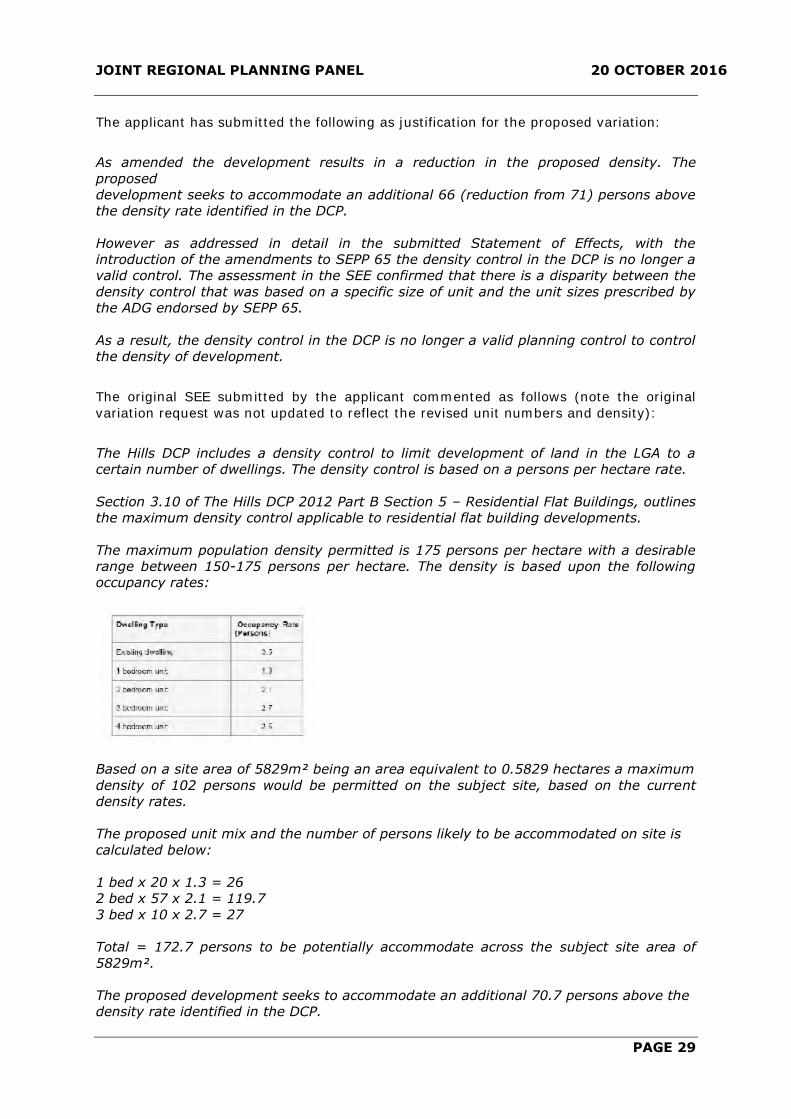
The maximum population density permitted is 175 persons per hectare with a desirable
range between 150-175 persons per hectare. The density is based upon the following
occupancy rates:
Based on a site area of 5829m² being an area equivalent to 0.5829 hectares a maximum
density of 102 persons would be permitted on the subject site, based on the current
density rates.
The proposed unit mix and the number of persons likely to be accommodated on site is
calculated below:
1 bed x 20 x 1.3 = 26
2 bed x 57 x 2.1 = 119.7
3 bed x 10 x 2.7 = 27
Total = 172.7 persons to be potentially accommodate across the subject site area of
5829m².
The proposed development seeks to accommodate an additional 70.7 persons above the
density rate identified in the DCP.

JOINT REGIONAL PLANNING PANEL 20 OCTOBER 2016
PAGE 30
As outlined above, the occupancy rate is based on a number of persons per unit type.
Accordingly, the maximum density in the DCP is directly linked to the configuration of
units and their unit size.
The introduction of the Apartment Design Guide and amendments to SEPP 65 overrides
the apartment sizes in the DCP. Clause 30 of the SEPP provides standards that cannot be
used as grounds to refuse development consent. Subclause (b) includes the ‘internal
area for each apartment will be equal to, or greater than, the recommended minimum
internal area for the relevant apartment type specified in Part 4D of the Apartment
Design Guide’. In addition, Clause 6A of the SEPP states that development control plans
cannot be inconsistent with the Apartment Design Guide in relation to a range of
requirements, including ‘apartment size’.
Accordingly, there is a disparity between the density control that was based on a specific
size unit and the current unit sizes prescribed by the ADG. As a result, the density
control in the DCP is no longer a valid planning control to control the density of
development.
It is reasonable to expect a larger proportion of residential units across a development
site when the overall minimum unit size has decreased, as it will result in excess floor
space creating the opportunity for additional dwellings.
It is on this basis that the density control in the DCP as is currently formed is no longer a
relevant control.
Furthermore, the density control in the DCP was originally based on larger unit sizes,
prior to the current control under Section 5 of the DCP. The unit sizes required were as
follows:
When the Hills DCP was amended to include a range of unit sizes as identified below, the
density control was not subsequently amended to reflect this significant change:
As noted above, the ADG overrides the DCP controls and accordingly negates the
effectiveness of the density control. It is contrary to the state planning regime that seeks
to reduce unit sizes and create more affordable housing options.

JOINT REGIONAL PLANNING PANEL 20 OCTOBER 2016
PAGE 31
By a direct comparison, prior to the changes to the unit sizes in the DCP, the density and
unit size controls envisaged approximately 2740m2 of additional floor space being
utilised on this site. This is calculated as the difference between the unit area
requirements when the density control was incorporated in the DCP and the average
proposed unit area under this DA. This again re-confirms the disparity between the
controls.
The comparison between the density control and floor space is a valid comparison as the
floor space reflects the anticipated built form on a development site. The density control
although considered no longer relevant given the disparity in unit sizes and unit
occupancy, is also about producing compatible housing and not over-taxing existing
services. In this regard, consideration is given to the objectives of the control.
The objectives of the density control are outlined below:
(i) To ensure residential flat building development does not over-tax existing
services and facilities; and
(ii) To provide opportunities for a suitable density housing form that is compatible
with the existing surrounding development.
The proposed development will increase density and will satisfy the zone objectives and
future character of the area. The development will be required to pay Section 94
Contributions to contribute to future facilities and services.
The site is located in close proximity to the future north-west railway line and within
close proximity to open space. The development will not over-tax existing services and
facilities, the DA demonstrates that appropriate stormwater water management and
traffic generation will result from this development.
In addition, this report demonstrates that the proposed development will not
unreasonably affect the lower density development to the south by way of
overshadowing, bulk and scale (due to generous landscaped setbacks) and privacy.
The site is ideally positioned adjacent to the B2 zone, with the adjacent site likely to be
developed in the future for a small village to service the neighbourhood. The proposed
residential flat buildings will provide an appropriate transition towards the lower density
zone and provide a buffer to the B2 zone.
It is therefore considered that the density control in this DCP is no longer a valid
planning control. A DCP is a discretionary document and can be varied without a formal
variation request. On the basis of the assessment provided above, it is considered that
the proposed density is appropriate and consistent with the spirit of the DCP.
Comment:
When considering the appropriateness of the density which is being proposed,
consideration should be afforded to the type of development envisaged at the time that
the existing controls were established, and the broader change in the expectation of
higher density development around town centres and transport nodes. Through this
strategic planning policy, Council has generally maintained a planned approach to
managing urban growth within the Shire, which makes use of existing infrastructure and
extends the lifestyle opportunities of its residents. This approach focuses high density
development in precincts that show capacity to accommodate further growth, with the
result being increased population around town centres and major transport nodes.

JOINT REGIONAL PLANNING PANEL 20 OCTOBER 2016
PAGE 32
The zoning of the area known as the Balmoral Road Release Area was originally zoned as
Rural 1(a) under LEP 1991. In 2003 and 2004 Council considered the rezoning of the
Balmoral Road Release Area and in September 2004 Council resolved to prepare a draft
Local Environmental Plan (LEP) and Development Control Plan (DCP). The draft LEP
proposed that the subject site be zoned Residential 2(a1) which allowed apartment
buildings. Amendment No. 5 of LEP 2005 came into force in April 2006 and the site was
rezoned to Residential 2(a1).
A key objective of this zone was to provide development for medium-density housing
forms (including apartment buildings, town-houses, villas and the like) in locations close
to the main activity centres of the local government area. This zone was a highly flexible
zone which permitted most forms of residential development including apartment
buildings, townhouses and dual occupancies.
The density range contained within the DCP is considered to be reflective of the zoning of
the site as it anticipates and guides the desired future character of the area.
The proposal could easily be amended to reflect the density rate contained within the
DCP. This would require a further review to be undertaken by the applicant of other key
controls within the DCP which have been sought to be varied, most notably the unit mix
and size requirements and height limits under both the LEP and DCP. An amended
design which reduces the scale of the development and responds appropriately to the
surrounding single residential development would also be more in keeping with the
expectations of residents.
It is noted that the applicant considers that the DCP rates are not a valid planning
consideration given the smaller unit areas contained within the ADG. In this regard, the
ADG unit areas are a minimum area and larger unit sizes are permitted. In this respect,
The Hills have always advocated larger unit sizes which are considered to better reflect
the desires of existing and future residents.
According the proposed is considered and over development of the site and warrants
refusal.
b. Assessment of Other Variations
As detailed in the table above, the applicant has also proposed variations to DCP
requirements in relation to number of storeys, setbacks, building design and streetscape,
urban design guidelines, unit layout and design (mix and size of units), private open
space, setback to the driveway and storage.
i. Number of storeys: the DCP limits the height of apartment buildings to four
storeys above ground level, however the proposed development has a height of
five storeys. The proposed height is unsatisfactory in regard to the interface to
the existing two storey low density residential character of the area. The
proposed height has not had adequate regard to the streetscape character, with
the proposed height adding to the scale of the development.
ii. Setbacks: the proposal includes encroachments into the setback of a fire stair,
entry and courtyards. The setback variations are considered minor and in
isolation could be supported, however when considered in conjunction with the
other variations, particularly height, number of storeys and density, the
cumulative impact of the variations result in an overdevelopment of the site.

JOINT REGIONAL PLANNING PANEL 20 OCTOBER 2016
PAGE 33
iii. Building design and streetscape and urban design guidelines: the proposal is
considered to be unsatisfactory in regard to its design and character. The
proposed five storey development does not respond to the existing low density
character of the area and is not in keeping with the desired scale and mass of
development. The proposal does not reflect the existing scale of development in
the area and does not respond to the interface between the two forms of
development.
iv. Unit layout and design (mix and size of units): the DCP requires that a mix of unit
sizes and types be provided in order to accommodate a range of housing types
and to facilitate housing diversity. The design provides only Type 1 units which
are the smallest unit type and does not provide a reasonable number of three
bedroom units, with only 7 x 3 bedroom units provided (8.1%). The proposal
does not provide a reasonable level of housing diversity for future residents.
v. Private open space: the DCP requires that all above ground units be provided with
a balcony with a minimum area of 10m2, however a number of units are provided
with a balcony of either 8m2 or 9m2. The balcony area variations are considered
minor and in isolation could be supported, however when considered in
conjunction with the other variations, particularly height, number of storeys and
density, the cumulative impact of the variations result in an overdevelopment of
the site.
vi. Setback to the driveway: The DCP requires that the access driveway be
centralised and have a 10m setback from any boundary. The proposed driveway
has a setback of approximately 350mm. The driveway setback variation is
considered minor and in isolation could be supported given the likely future
development to the north.
vii. Storage: the DCP requires 10m3 of storage within a lockable garage, however the
majority of units do not provide 10m3 and the storage area is split between the
internal and basement storage. The storage variation is considered minor and in
isolation could be supported.
The variations identified cannot be supported given they primarily relate to the
overdevelopment of the site and relate to the application of the density controls by the
applicant. In this regard, compliance with the LEP and DCP height limit and density
requirements would likely result in a proposal which was compliant with the DCP
requirements. Whilst some variations could be considered on merit having regard to the
built form outcome, the development in its current form is considered to be an over-
development of the site which does not have adequate regard to the low density nature
of the area and the interface to the adjoining development.
c. Insufficient Information
In addition, the applicant has not submitted adequate information to allow a full
assessment to be undertaken of stormwater management and vehicle access and waste
management arrangements.
5. SEPP 65 and Apartment Design Guidelines
The proposal has been accompanied by a Design Verification Statement by a chartered
architect which confirms that the proposal is satisfactory with regard to the provisions of
SEPP 65.

JOINT REGIONAL PLANNING PANEL 20 OCTOBER 2016
PAGE 34
The proposal has been assessed against the provisions of the Apartment Design
Guidelines as outlined below:
Clause Design Criteria Compliance
Siting
Communal open
space
25% of the site, with 50% of the area
achieving a minimum of 50% direct
sunlight for 2 hours midwinter.
The proposal
provides 1462m2 of
common open space
which is 25.1% of
the site. Adequate
solar access is
provided to the
common open space.
Deep Soil Zone 7% of site area. On some sites it may be
possible to provide a larger deep soil zone,
being 10% for sites with an area of 650-
1500m2 and 15% for sites greater than
1500m2.
An area of 1938m2 or
33.2% of the site is
deep spoil zone.
Separation For habitable rooms, 6m for 4 storeys, 9m
for 5-8 storeys and 12m for 9+ storeys.
The buildings are 5
storey in height. A
12m separation is
provided between the
buildings.
Visual privacy Visual privacy is to be provided through
use of setbacks, window placements,
screening and similar.
The proposed design
of the units provides
appropriate privacy
to adjoining
development and
between units for
future residents.
Carparking Carparking to be provided based on
proximity to public transport in
metropolitan Sydney. For sites within
800m of a railway station or light rail stop,
the parking is required to be in accordance
with the RMS Guide to Traffic Generating
Development which is:
Metropolitan Sub-Regional Centres:
0.6 spaces per 1 bedroom unit.
0.9 spaces per 2 bedroom unit.
1.40 spaces per 3 bedroom unit.
1 space per 5 units (visitor parking).
The site is not within
800m of a railway
station of light rail
stop. The closest
station to the site will
be Norwest Station
which is
approximately 2.4
kilometres from the
site.
Designing the Building
Solar and daylight
access
Living and private open spaces of at least
70% of apartments are to receive a
minimum of 2 hours direct sunlight
between 9am and 3pm midwinter.
All of the units meet
the solar access
requirements with
balconies and living
areas oriented north.
Natural ventilation At least 60% of units are to be naturally
cross ventilated in the first 9 storeys of a
building. For buildings at 10 storeys or
greater, the building is only deemed to be
cross ventilated if the balconies cannot be
fully enclosed.
70% of the units
achieve natural
ventilation.

JOINT REGIONAL PLANNING PANEL 20 OCTOBER 2016
PAGE 35
Ceiling heights For habitable rooms – 2.7m.
For non-habitable rooms – 2.4m.
For two storey apartments – 2.7m for the
main living floor and 2.4m for the second
floor, where it’s area does not exceed 50%
of the apartment area.
For attic spaces – 1.8m at the edge of the
room with a 300 minimum ceiling slope.
If located in a mixed use areas – 3.3m for
ground and first floor to promote future
flexible use.
All of the units have
a habitable room
ceiling height of
2.7m.
Apartment size Apartments are required to have the
following internal size:
Studio – 35m2
1 bedroom – 50m2
2 bedroom – 70m2
3 bedroom – 90m2
The minimum internal areas include only
one bathroom. Additional bathrooms
increase the minimum internal areas by
5m2 each.
A fourth bedroom and further additional
bedrooms increase the minimum internal
area by 12m2 each.
All of the units
comply with the
required floor area.
Note: all of the 2 and
3 bedroom units
have two bathrooms
and therefore the
unit size
requirements are
increased to 75m2
and 95m2
respectively.
Apartment layout Habitable rooms are limited to a maximum
depth of 2.5 x the ceiling height.
In open plan layouts the maximum
habitable room depth is 8m from a
window.
The proposed layouts
are satisfactory. All
rooms contain a
window within 8m or
less.
Balcony area The primary balcony is to be:
Studio – 4m2 with no minimum depth
1 bedroom – 8m2 with a minimum depth of
2m
2 bedroom – 10m2 with a minimum depth
of 2m
3 bedroom – 12m2 with a minimum depth
of 2.4m
For units at ground or podium levels, a
private open space area of 15m2 with a
minimum depth of 3m is required.
The units all have
compliant balcony
areas.
Storage Storage is to be provided as follows:
Studio – 4m3
1 bedroom – 6m3
2 bedroom – 8m3
3+ bedrooms – 10m3
At least 50% of the required storage is to
be located within the apartment.
The units all have
adequate storage
areas.
Apartment mix A variety of apartment types is to be
provided and is to include flexible
apartment configurations to support
diverse household types and stages of life.
The proposal
provides and
adequate unit mix.

JOINT REGIONAL PLANNING PANEL 20 OCTOBER 2016
PAGE 36
The subject Development Application has been assessed against the relevant design
quality principles contained within the SEPP as follows:
Concern is raised that the proposal fails to appropriately consider the following Principles
of SEPP 65
Principle No. 1 – Context and Neighbourhood Character;
Principle No. 2 – Built Form and Scale;
Principle No. 3 – Density; and
Principle No. 6 – Amenity
Principle 1: Context and neighbourhood character
Good design responds and contributes to its context. Context is the key natural and built
features of an area, their relationship and the character they create when combined. It
also includes social, economic, health and environmental conditions.
Responding to context involves identifying the desirable elements of an area’s existing or
future character. Well-designed buildings respond to and enhance the qualities and
identity of the area including the adjacent sites, streetscape and neighbourhood.
Consideration of local context is important for all sites, including sites in established
areas, those undergoing change or identified for change.
Principle 2: Built form and scale
Good design achieves a scale, bulk and height appropriate to the existing or desired
future character of the street and surrounding buildings.
Good design also achieves an appropriate built form for a site and the building’s purpose
in terms of building alignments, proportions, building type, articulation and the
manipulation of building elements.
Appropriate built form defines the public domain, contributes to the character of
streetscapes and parks, including their views and vistas, and provides internal amenity
and outlook.
Principle 3: Density
Good design achieves a high level of amenity for residents and each apartment, resulting
in a density appropriate to the site and its context.
Appropriate densities are consistent with the area’s existing or projected population.
Appropriate densities can be sustained by existing or proposed infrastructure, public
transport, access to jobs, community facilities and the environment.
Principle 6: Amenity
Good design positively influences internal and external amenity for residents and
neighbours. Achieving good amenity contributes to positive living environments and
resident well-being.
Good amenity combines appropriate room dimensions and shapes, access to sunlight,
natural ventilation, outlook, visual and acoustic privacy, storage, indoor and outdoor
space, efficient layouts and service areas and ease of access for all age groups and
degrees of mobility.

JOINT REGIONAL PLANNING PANEL 20 OCTOBER 2016
PAGE 37
Comment:
The proposal does not provide a development that responds to the desired future
context and character of the locality. The development seeks to provide a built form that
is considered excessive in respect to height and density. The proposal will result in poor
amenity for residents being located within the site and for existing residents adjacent to
the site.
The development in its current form is considered to be an over-development of the site
which does not have adequate regard to the low density nature of the area and the
interface to the adjoining development. In this regard the surrounding development
generally comprises two storey attached and detached dwellings. The proposed
development has a height of five storeys which is considered to be out of character with
the existing built form of the area.
6. Issues Raised in Submissions
The proposal was advertised and notified to adjoining property owners and 34
submissions and a petition signed by an additional 30 persons was received. Upon
receipt of amended plans and information, the proposal was re-notified to adjoining
property owners and those who made a submission to the original plans and in response
nine submissions were received. The following table outlines the issues raised in all
submissions and at the Conciliation Conference.
ISSUE/OBJECTION COMMENT OUTCOME
Increase in traffic in local
streets.
Council’s Principal Co-ordinator Road
and Transport has revised the
proposal and advised that the
proposal will generate in the order of
25 peak hours trips. The proposed
traffic generation is relatively minor
and acceptable.
Issue addressed.
Safety concerns due to
increased traffic.
The proposed low traffic generation of
the development will not result in
decreased safety.
Issue addressed.
Adequacy of resident and
visitor parking. The
parking may comply with
Council requirements, but
residents believe it will still
not be adequate. Due to
socio-economic factors,
most dwellings will have
2-3 cars.
The proposal provides 186 parking
spaces within the basement parking
areas which comprise 151 resident
spaces and 35 visitor spaces. The
proposal complies with Council’s DCP
parking requirement and additional
parking provision beyond the DCP
rates is at the developers discretion.
Issue addressed.
Street parking will occur
as the entrances to the
buildings are from Affleck
Circuit.
The proposal complies with Council’s
DCP parking requirement. However it
is acknowledged that some on-street
parking may occur.
Issue addressed.
Affleck Circuit will become
a main traffic
thoroughfare.
Council’s Principal Co-ordinator Road
and Transport has revised the
proposal and advised that the
proposal will generate in the order of
25 peak hours trips. The proposed
traffic generation is minor. Given the
Issue addressed.
JOINT REGIONAL PLANNING PANEL 20 OCTOBER 2016
PAGE 38
ISSUE/OBJECTION COMMENT OUTCOME
location of the driveway on the
extension of Severn Vale Drive, there
is unlikely to be an unreasonable
increase in traffic of Affleck Circuit.
Safety to pedestrians and
drivers due to increased
traffic
The proposed low traffic generation of
the development will not result in
decreased safety.
Issue addressed.
Increase in traffic due to
the closure of Hector Court
which will result in
vehicles traveling along
Affleck Circuit to access
Severn Vale Drive.
It is acknowledged that there will be
some changes to traffic flow due to
local road closures and openings
which will occur in the future,
however these changes are not due to
the current application.
Issue addressed.
Increase in traffic on local
roads due to the shopping
centre adjoining the site
and the new sporting
complex proposed on
Balmoral Road.
It is acknowledged that there will be
some changes to traffic flow due to
the development of the adjoining site
to the north for commercial purposes
and the sporting complex on Balmoral
Road. However the local road
hierarchy which proposes enhanced
collector roads at these locations has
been planned and considered as part
of the DCP local road upgrades.
Issue addressed.
Increase in noise,
including noise from future
residents and from
increased traffic.
The proposed apartment development
is unlikely to result in any
unreasonable noise impacts.
Issue addressed.
Proposal is out of
character with the
predominantly single
dwelling and townhouse
nature of the area.
The proposed height and density are
considered unsatisfactory and the
development is out of character with
the adjoining development – see
Sections 2 and 4 above.
Recommended for
refusal.
Impact on amenity and
wellbeing. Impact on a
quiet, family
neighbourhood area. The
proposal is out of
character with the existing
development in the area.
The proposed height and density are
considered unsatisfactory and the
development is out of character with
the adjoining development – see
Sections 2 and 4 above.
Recommended for
refusal.
Height, including that the
height is above the 16m
limit.
The proposed height is considered
unsatisfactory – see Sections 2 and 4
above.
Recommended for
refusal.
The height will be above
the adjoining shopping
centre and the existing
residential dwellings.
The proposed height is considered
unsatisfactory – see Sections 2 and 4
above.
Recommended for
refusal.
Loss of
sunlight/overshadowing to
residential dwellings on
Affleck Circuit.
The proposal will impact on solar
access to the front yards of properties
opposite (on Affleck Circuit) at 9am,
10am and 3pm on June 21, however
the impact is considered acceptable.
See shadow diagrams at Attachment
8.
Issue addressed.

JOINT REGIONAL PLANNING PANEL 20 OCTOBER 2016
PAGE 39
ISSUE/OBJECTION COMMENT OUTCOME
Size, bulk, scale and
proportion of the
buildings. The buildings
are obtrusive.
The proposed height and density are
considered unsatisfactory – see
Sections 2 and 4 above.
Recommended for
refusal.
Impact on views. It is acknowledged that the views are
currently to a residential property
which is likely to be redeveloped
given the zoning, therefore there is
not an unreasonable impact on views.
Issue addressed.
Tall buildings are visually
unattractive.
High buildings need not be visually
unattractive but the five level
presentation to low density housing
provides an unsatisfactory interface
relationship.
Issue addressed.
The area does not have
access to public transport
or facilities. There is a lack
of public transport in the
area.
As part of the upgrade works in the
area new T-Way bus stops will be
incorporated along Memorial Road.
Route services on Fairway Drive,
Severn Vale Drive and Free Settlers
Drive will be provided and will be
utilised by local bus services as
demand is warranted.
Issue addressed
Road infrastructure in the
area must be completed
before further
development is permitted.
The RMS are proposing to upgrade
Memorial Avenue to four lanes over
the next 12-18 months (subject to
State Government funding), further
enhancing performance levels of the
road carriageway and future
signalised intersections. The
development of the site is not reliant
on the local road upgrade works
which are primarily funded through
Section 94 contributions.
Issue addressed.
The existing road access
to Memorial Avenue is
dangerous.
The RMS are proposing to upgrade
Memorial Avenue to four lanes over
the next 12-18 months (subject to
State Government funding), further
enhancing performance levels of the
road carriageway and future
signalised intersections.
Issue addressed.
Residents believed that
townhouses would be built
on the site, not
apartments, and that the
site was zoned for medium
density use.
The proposed development is a
permissible use in the R4 High
Density Residential zone.
Issue addressed.
Increase in density of the
area.
The proposed density is considered
unsatisfactory – see Section 4 above.
Recommended for
refusal.
Covenants on the land
limit development to low
density housing only.
The proposed development is a
permissible use in the R4 High
Density Residential zone under LEP
2012.
Issue addressed.
JOINT REGIONAL PLANNING PANEL 20 OCTOBER 2016
PAGE 40
The zoning of land has
changed since 2009 when
residents purchased
property on Affleck Circuit.
Residents were not
advised of the change in
zoning. Request that the
zoning be amended to R3
Medium Density
Residential.
The site was rezoned in 2006 to
Residential 2(a1) which allowed
apartment buildings. The zoning was
subsequently altered by LEP 2012 to
R4 High Density Residential reflect the
standard LEP template. Apartment
buildings continued to be a
permissible use in the R4 High
Density Residential.
Issue addressed.
The proposal should be
sited closer to the North
West rail corridor which is
better suited to high
density development.
The proposed development is a
permissible use in the R4 High
Density Residential zone under LEP
2012. The site is located adjoining a
future commercial development and
has a reasonable level of access to
public transport.
Issue addressed.
The development is not
within 500m of a railway
station.
The proposed development is a
permissible use in the R4 High
Density Residential zone under LEP
2012. The site has a reasonable level
of access to public transport.
Issue addressed.
Increase in pollution. The proposed apartment development
is unlikely to result in any
unreasonable pollution impacts.
Issue addressed.
Neighbour notification
should have been
extended to all residents
in Hector Court, Grace
Crescent, Willox Avenue
and Severn Vale Drive.
The proposal was advertised and
notified to residents in accordance
with Council’s notification
requirements within the DCP.
Issue addressed.
Impact on property values
and saleability.
There has been no evidence
submitted that there will be a
decrease in property values or sales.
The loss of property values is not a
planning consideration.
Issue addressed.
Small apartments will
change the demographic
of the area. The area is
currently characterised by
families.
The introduction of apartment
development may change the
demographic of the area however this
is not considered to be an
unreasonable impact.
Issue addressed.
Concerns with the number
of higher density
developments being built
or planned around
Balmoral Road, Memorial
Drive, Windsor Road and
Old Windsor Road.
The Balmoral Road area is one which
is undergoing change from the
previous rural land uses to a
residential and commercial nature.
The increased apartment development
is consistent with the directives from
the Department of Planning and
Environment to increase this form of
development in key locations.
Issue addressed.
The development is solely
based on money making
from the units proposed
which will be sold at an
inflated price.
It is acknowledged that the developer
will seek to ensure a return on
investment. This is not a planning
matter for consideration.
Issue addressed.

JOINT REGIONAL PLANNING PANEL 20 OCTOBER 2016
PAGE 41
A three storey apartment
development would be
fair. A townhouse
development would be
more appropriate.
The proposed development is a
permissible use in the R4 High
Density Residential zone under LEP
2012. The site. The proposed height
exceeds the LEP height standard and
DCP number of storeys and is
unsatisfactory.
Recommended for
refusal.
Concern that the original
Residential 2(a1) zoning
was applied to the site
with no consideration of
impacts to future
residents. No-one can
explain the reasoning
behind the zoning.
The rezoning of the Balmoral Road
area was the subject of a number of
reports to Council and exhibition of
the plans to the public. It is assumed
that the Residential 2(a1) zoning was
applied to the site due to the
relationship with the B2 Local Centre
zone to the north.
Issue addressed.
Concern that the
interactive mapping shown
on Council’s website is
misleading as zoning
notations are shown on
other properties that are
not zoned for that
purpose.
It was noted that the information
contained on the interactive mapping
comes from the Department of
Planning and Environment and is
designed for people to check the
zoning of a particular property. Lines
drawn from labels to particular
properties are actually correct but
difficult to see.
Issue addressed.
Residents were aware of
the R3 Medium Density
zoning in the Grace
Crescent area and the
approval in place on Lot
102 for integrated housing
and were generally
satisfied with that form of
development. Residents
believe integrated housing
would be a better outcome
for the development of the
site.
The proposed development is a
permissible use in the R4 High
Density Residential zone under LEP
2012. Other forms of residential
development are also permissible
within the zone.
Issue addressed.
At a briefing held by the
Department of Planning
regarding rail corridor
development, a
Department staff member
advised that it was ‘more
likely that the site was
zoned for medium density’
use.
The proposed development is a
permissible use in the R4 High
Density Residential zone under LEP
2012. Other forms of residential
development are also permissible
within the zone.
Issue addressed.
This site is the only site
zoned for high density
planned so far from the
future station. The site is
over 2 kilometres from the
station. The proposal is
contrary to a newspaper
article which said that the
Council wanted higher
The proposed development is a
permissible use in the R4 High
Density Residential zone under LEP
2012. Other forms of residential
development are also permissible
within the zone. It is assumed that
the zoning comes about due to the
relationship with the B2 Local Centre
zone to the north.
Issue addressed.

JOINT REGIONAL PLANNING PANEL 20 OCTOBER 2016
PAGE 42
density housing closer to
the future stations. The
future rail station was
previously located closer
to the site and some
residents believe this was
why the site was zoned for
higher density housing.
Residents wish to
challenge the R4 High
Density Residential zoning.
The current zoning is in place. The
Department of Planning and
Environment are highly unlikely to
‘down-zone’ a property.
Issue addressed.
Conveyancers did not
advise residents when
they were purchasing land
in the area that the site
was R4 High Density
Residential.
This is a private matter between the
purchaser and conveyancer. It is
noted however that conveyancing
advice is usually limited to the site
being purchased and does not address
adjoining sites.
Issue addressed.
The need for the closure of
Hector Court and the
opening/construction of a
new access point through
the extension of Severn
Vale Drive.
The closure of Hector Court and the
new access to Memorial Avenue is
part of the local road improvements in
place as part of Council’s DCP
requirements. The subdivision of land
and existing and future development
has been predicated on the DCP.
Issue addressed.
Need for signalisation of
roads and traffic
improvements within the
area.
The RMS are proposing to upgrade
Memorial Avenue to four lanes over
the next 12-18 months (subject to
State Government funding), further
enhancing performance levels of the
road carriageway and future
signalised intersections.
Issue addressed.
Parking will occur on local
streets as it is more
convenient for residents
and visitors.
It is likely that some people will park
on the street if it is more convenient
regardless of parking provision on the
site. Notwithstanding this, the
proposal complies with Council’s DCP
parking requirements.
Issue addressed.
Residents often use
garages for storage
purposes.
The proposal complies with Council’s
DCP parking requirements and
storage areas have been provided for
each unit. If approval was granted a
condition could be imposed requiring
parking to be available and not used
for storage.
Issue addressed.
Children will not be able to
play freely in front yards
due to increased traffic.
The proposed apartment development
will not limit children playing within a
private front yard.
Issue addressed.
Has increased traffic from
the new railway stations
been included in the traffic
report?
The traffic generated by the railway
station precincts has been considered
in the traffic report commissioned by
Transport for NSW as part of the
overall structure plans. The opening
of the rail link will change traffic flow
in the area and will reduce commuter
Issue addressed.

JOINT REGIONAL PLANNING PANEL 20 OCTOBER 2016
PAGE 43
road trips. Kellyville and Bella Vista
Stations will attract commuters as
they will have parking stations which
will likely generate additional traffic
on Memorial Avenue hence the need
for the four lane upgrade works.
The closure of Fairway
Drive at Windsor Road will
result in increased traffic
using Severn Vale Drive to
access Memorial Avenue.
It is acknowledged that there will be
some changes to traffic flow due to
local road closures and openings
which will occur in the future,
however these changes are not due to
the current application.
Issue addressed.
Parking provided outside
of basements is more
accessible and attractive
for people to park in.
The provision of basement parking
allows a more efficient use of the site.
Basement parking is convenient and
limits external hard paved areas.
Issue addressed.
Accident history on
Memorial Avenue.
A number of accidents have occurred
on Memorial Road in the past,
generally at intersections. The road
upgrade works and signalised
intersections will assist in reducing
accidents and will improve road
safety.
Issue addressed.
The proposal is contrary to
the objectives of the DCP.
The proposal includes a number of
variations to the DCP requirements –
see Section 4 above.
Recommended for
refusal.
The proposal is contrary to
the R4 High Density
Residential zone
objectives.
It is considered that the proposed
development is not necessarily
inconsistent with the zone objectives
however concern is raised that the
proposal does not meet the intent of
the R4 High Density Residential zone
given the density proposed.
Recommended for
refusal.
Interface with other low
density development in
the area.
The proposed five storey design is out
of character with the existing
surrounding development and does
not adequately address the interface.
Recommended for
refusal.
Impacts on privacy,
especially due to the
proposed height.
Given the proposed separation to
existing residential dwellings, there is
unlikely to be any unreasonable
privacy impacts.
Issue addressed.
Future development of the
B2 Local Centre land to
the north by Woolworths.
To date, a Development Application
has not been lodged for development
of the B2 Local Centre land to the
north.
Issue addressed.
Additional/Further Issues raised during the Second Notification Period
Density of population. The
reduction of one unit does
not address the concerns
raised. The proposal
should be amended to
comply.
The proposed density is considered
unsatisfactory and the development is
out of character with the adjoining
development – see Section 4 above.
Recommended for
refusal.

JOINT REGIONAL PLANNING PANEL 20 OCTOBER 2016
PAGE 44
The revised proposal does
not address the
community concerns.
The proposed development is
considered unsatisfactory and is not
supported.
Recommended for
refusal.
The lift shafts continue to
breach the LEP height
limit. The proposal should
comply fully.
The proposed height is considered
unsatisfactory and the development is
out of character with the adjoining
development – see Section 2 above.
Recommended for
refusal.
The proposal is 5 storey,
where the limit is four
storey.
The proposed height is considered
unsatisfactory and the development is
out of character with the adjoining
development – see Section 2 above.
Recommended for
refusal.
A redesign to a layout with
no one bedroom units and
larger and more
‘upmarket’ units would be
more fitting to the area.
The current unit mix and types do not
comply with the DCP requirements. A
redesign of the proposal to meet the
DCP requirements would allow a more
appropriate development.
Recommended for
refusal.
The shopping centre has
recently been re-zoned to
B2. The initial zoning only
anticipated a small strip
centre, not a major
centre. The arguments
from the developer
regarding the zoning of
this site in relation to the
centre are now invalid.
The DCP refers to the site as a ‘village
centre’ which has the objective to
meet the weekly convenience
shopping needs of residents, with a
scale that is in keeping with
surrounding residential character. To
date, a Development Application has
not been lodged for development of
the B2 Local Centre land to the north.
Issue addressed.
TRAFFIC MANAGEMENT COMMENTS
i. Existing Traffic Environment
This application proposes to construct an 86 unit residential apartment development
comprising 21 x 1, 58 x 2 and 7 x 3 bedroom apartments with 186 off street parking
spaces at 2B Hector Court, Kellyville forming part of the Balmoral Road release area.
A traffic impact statement has been prepared by Thompson Stanbury Associates and
submitted in support of the application. As referred in the consultant’s report Hector
Court, in its current configuration, intersects with Memorial Avenue via a three way ‘Give
Way’ sign controlled intersection and performs a precinct access function by virtue of its
previous status as Balmoral Road. It is primarily constructed to a two lane rural road
standard with a 7.0m sealed carriageway and 2.0m wide unsealed shoulders servicing
the remaining rural allotments and more recent higher density residential developments
in the area.
Under the future release area configuration Hector Court is to be closed at Memorial
Avenue with Severn Vale Drive assuming the enhanced collector road function via a new
four way signalised intersection at Memorial Avenue. As an enhanced collector with a
12.0m wide carriageway Severn Vale Drive is expected to cater for peak hour traffic
demand of around 400-450 vehicles per hour.
ii. Proposed Development - Traffic Generation
The Roads and Traffic Authority Guide to Traffic Generating Developments nominates a
specific traffic generation rate for higher density apartments at around 0.29 am peak
hour trips per unit. On this basis an apartment complex with 87 units will generate in the
order of 25 peak hour trips.

JOINT REGIONAL PLANNING PANEL 20 OCTOBER 2016
PAGE 45
a. Need for Traffic Improvements in the Locality
The relatively low total traffic volume expected to be generated by this proposal will
have minimal impact on service levels of the future enhanced collector of Severn Vale
Drive or the operational performance of the future signalized intersection with Memorial
Avenue. The applicant will be required to pay the appropriate Section 94 contributions
towards the cost of future traffic and open space facilities in the locality.
b. Traffic egress/ingress to arterial/sub-arterial roads
As indicated above, Severn Vale Drive is a currently a no-through local access road with
Hector Court performing the precinct collector road function until surrounding
development activity occurs allowing the future signalized intersection with Memorial
Avenue.
The RMS are proposing to upgrade Memorial Avenue to four lanes over the next 12-18
months (subject to State Government funding), further enhancing performance levels of
the road carriageway and future signalized intersections.
c. Sight distance and other safety issues
The site is located on the northern side of Affleck Circuit bounded by Hector Court and
Severn Vale Drive. All vehicular access is proposed via a combined entry/exit driveway
located on the Severn Vale Drive frontage of the property. Sight distance for vehicles
entering and exiting the property will be consistent with the recommended minimum
Safe Intersection Sight Distance of 80m for a 50km/h urban road as required under the
Austroad’s Guidelines.
iii. Recommendations
There are no objections raised from a traffic engineering perspective to the proposed
development.
SUBDIVISION ENGINEERING COMMENTS
The applicant has not provided information in regard to:
The design of the extension of Severn Vale Drive;
Partial width road construction of Hector Court;
Swept turning path analysis and clearances on the ramps;
The provision of separate facilities for turning before the security doors to allow
vehicles to exit if a residents is unavailable or denies access to a visitor.
TREE MANAGEMENT COMMENTS
No objection raised to the proposal.
HEALTH & ENVIRONMENTAL PROTECTION COMMENTS
No objection raised to the proposal.

JOINT REGIONAL PLANNING PANEL 20 OCTOBER 2016
PAGE 46
WASTE MANAGEMENT COMMENTS
The applicant has not adequately demonstrated that the waste vehicles can enter and
exit the site in an appropriate manner in regard to compliance with the Australian
Standards, swept turning paths and access to the basement.
NSW POLICE COMMENTS
The NSW Police have reviewed the Development Application and outlined a number of
Crime Prevention Through Environmental Design (CPTED) recommendations to ensure
that the site is appropriately protected.
CONCLUSION
The application has been assessed against the provisions of Section 79C of the
Environmental Planning and Assessment Act 1979, Local Environmental Plan 2012 and
The Hills Development Control Plan 2012 and is considered unsatisfactory.
The proposed development is considered to be inconsistent with the objectives of the
zone and is considered an overdevelopment of the site.
Accordingly, the application is recommended for refusal
IMPACTS:
Financial
This matter may have a direct financial impact upon Council’s adopted budget as refusal
of this matter may result in Council having to defend a Class 1 Appeal in the NSW Land
and Environment Court.
The Hills Future - Community Strategic Plan
The social and environmental impacts have been identified and addressed in the report.
The proposal conflicts with the development objectives of the LEP and DCP. It is
considered unsatisfactory with regard to The Hills Future Community Strategic Plan.
RECOMMENDATION
The Development Application be refused for the following reasons:
1. The proposal exceeds to LEP height standard and has not been accompanied by a
Clause 4.6 variation request (Section 79C(a)(i) of the Environmental Planning and
Assessment Act 1979).
2. The proposal is unsatisfactory in regard to the requirements of Part B Section 5
Residential Flat Buildings in regard to density, number of storeys, setbacks, unit
layout and design, open space and storage (Section 79C 1(a)(i) of the NSW
Environmental Planning and Assessment Act 1979).
3. The proposed development results in an overdevelopment of the site which is
incompatible with adjoining residences and neighbourhood character (Section 79C
1(a)(i) of the NSW Environmental Planning and Assessment Act 1979).

JOINT REGIONAL PLANNING PANEL 20 OCTOBER 2016
PAGE 47
4. The proposal does not comply with the Design Principles of State Environmental
Planning Policy No. 65 – Design Quality of Residential Flat Development in terms
of:
Principle No. 1 – Context and Neighbourhood Character;
Principle No. 2 – Built Form and Scale;
Principle No. 3 – Density; and
Principle No. 6 – Amenity
(Section 79C(a)(i) of the Environmental Planning and Assessment Act 1979).
5. The proposed development is contrary to the provisions of Clause 50 of the NSW
Environmental Planning and Assessment Regulations 2000, which requires the
applicant to provide all the necessary and requested information to Council to
allow for a proper assessment of the application, including the submission of
information including engineering matters and waste matters, specifically in
regard to waste management vehicle access, the design of the extension of
Severn Vale Drive, partial width road construction of Hector Court, swept turning
path analysis and clearances on the ramps and the provision of separate facilities
for turning before the security doors (Section 79C 1(a)(iv) of the NSW
Environmental Planning and Assessment Act, 1979).
6. The impacts on and built environment in the locality are unacceptable in terms of
bulk and scale of the proposed building which is not compatible with the
surrounding development and the overall streetscape (Section 79C 1(b) of the
NSW Environmental Planning and Assessment Act 1979).
7. The development is not considered to be suitable for the site as it is an
overdevelopment in terms of scale and intensity and results in unacceptable
amenity impacts on neighbours (Section 79C 1(c) of the NSW Environmental
Planning and Assessment Act 1979).
8. The development is considered not to be in the public interest (Section 79C 1(e)
of the NSW Environmental Planning and Assessment Act 1979).
ATTACHMENTS
1. Locality Plan
2. Aerial Photograph
3. LEP Height Standard
4. LEP Zoning Plan
5. Site Plan
6. Elevation showing LEP Height Limit
7. Elevation Plans
8. Shadow Diagrams
9. Section
10. Isometric Model
11. External Colour Scheme
12. Original Perspectives

JOINT REGIONAL PLANNING PANEL 20 OCTOBER 2016
PAGE 48
ATTACHMENT 1 – LOCALITY PLAN

JOINT REGIONAL PLANNING PANEL 20 OCTOBER 2016
PAGE 49
ATTACHMENT 2 – AERIAL PHOTOGRAPH

JOINT REGIONAL PLANNING PANEL 20 OCTOBER 2016
PAGE 50
ATTACHMENT 3 – LEP HEIGHT STANDARD

JOINT REGIONAL PLANNING PANEL 20 OCTOBER 2016
PAGE 51
ATTACHMENT 4 – LEP ZONING PLAN

JOINT REGIONAL PLANNING PANEL 20 OCTOBER 2016
PAGE 52
ATTACHMENT 5 – SITE PLAN
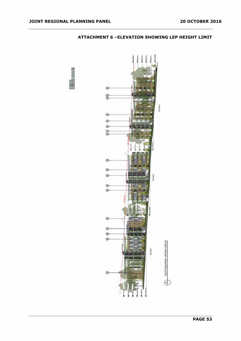
JOINT REGIONAL PLANNING PANEL 20 OCTOBER 2016
PAGE 53
ATTACHMENT 6 –ELEVATION SHOWING LEP HEIGHT LIMIT

JOINT REGIONAL PLANNING PANEL 20 OCTOBER 2016
PAGE 54
ATTACHMENT 7 –ELEVATION PLANS

JOINT REGIONAL PLANNING PANEL 20 OCTOBER 2016
PAGE 55
ATTACHMENT 8 –SHADOW DIAGRAMS

JOINT REGIONAL PLANNING PANEL 20 OCTOBER 2016
PAGE 56
ATTACHMENT 9 – SECTION
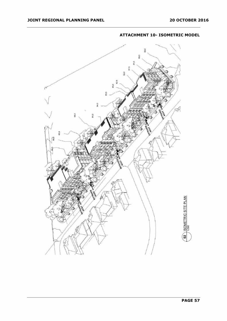
JOINT REGIONAL PLANNING PANEL 20 OCTOBER 2016
PAGE 57
ATTACHMENT 10- ISOMETRIC MODEL

JOINT REGIONAL PLANNING PANEL 20 OCTOBER 2016
PAGE 58
ATTACHMENT 11 – EXTERNAL COLOUR SCHEME

JOINT REGIONAL PLANNING PANEL 20 OCTOBER 2016
PAGE 59
ATTACHMENT 12 – ORIGINAL PERSPECTIVES

JOINT REGIONAL PLANNING PANEL 20 OCTOBER 2016
PAGE 60

JOINT REGIONAL PLANNING PANEL 20 OCTOBER 2016
PAGE 61
ITEM-2 JRPP REPORT- DA 1395/20916/JP
(Sydney West)
JRPP No 2016SYW063
DA Number DA 1395/2016/JP
Local Government Area THE HILLS SHIRE COUNCIL
Proposed Development DEMOLITION OF EXISTING STRUCTURES AND
CONSTRUCTION OF A MIXED USE DEVELOPMENT
CONTAINING 247 RESIDENTIAL UNITS, GROUND FLOOR
RETAIL, THREE (3) LEVELS OF COMMERCIAL OFFICES
AND FIVE (5) LEVELS OF PARKING PROVIDING 646 CAR
PARKING SPACES.
Street Address LOT 5074 DP 1003042, 11-13 SOLENT CIRCUIT,
BAULKHAM HILLS AND LOT 102 DP 1065520
Applicant CAPITAL BLUESTONE
Number of Submissions EIGHT (8) SUBMISSIONS
Regional Development
Criteria (Schedule
4A of the Act)
CIV Over $20 Million – General Development
List of All Relevant
s79C(1)(a) Matters
List all of the relevant environmental planning instruments:
s79C(1)(a)(i)
- The Hills Local Environmental Plan 2012
- State Environmental Planning Policy (Infrastructure)
2007
- State Environmental Planning Policy No. 55 –
Remediation of Land
- State Environmental Planning Policy No. 65 – Design
Quality of Residential Flat Development
- State Environmental Planning Policy (Building
Sustainability Index: BASIX) 2004
- State Environmental Planning Policy (State and Regional
Development) 2011
List any proposed instrument that is or has been the subject
of public consultation under the Act and that has been
notified to the consent authority: s79C(1)(a)(ii)
- Nil
List any relevant development control plan: s79C(1)(a)(iii)
- DCP 2012 Part C Section 6 – Business
- DCP 2012 Part B Section 5 – Residential Flat Buildings
- DCP 2012 Part C Section 1 – Parking
List any relevant planning agreement that has been entered
into under section 93F, or any draft planning agreement that
a developer has offered to enter into under section 93F:
s79C(1)(a)(iv)
JOINT REGIONAL PLANNING PANEL 20 OCTOBER 2016
PAGE 62
- Voluntary Planning Agreement for 11-13 Solent Circuit
Baulkham Hills between The Hills Shire Council and Hills
Christian Life Centre Limited and Capital Corporation
(Waterside) Pty Ltd, dated July 2015.
List any coastal zone management plan: s79C(1)(a)(v)
- Nil
List any relevant regulations: s79C(1)(a)(iv) eg. Regs 92,
93, 94, 94A, 288
- Environmental Planning and Assessment Act Regulation
2000
Does the DA require
Special Infrastructure
Contributions
conditions (s94EF)?
No
List all documents
submitted with this
report for the panel’s
consideration
Submissions and Clause 4.6 Written Request
Recommendation Approval
Report by Development Assessment Coordinator
James McBride
Report date 20 October 2016
Summary of S.79C matters
Have all recommendations in relation to relevant s79C matters been
summarised in the Executive Summary of the assessment report?
Yes
Legislative clauses requiring consent authority satisfaction
Have relevant clauses in all applicable environmental planning instruments
where the consent authority must be satisfied about a particular matter
been listed, and relevant recommendations summarised, in the Executive
Summary of the assessment report?
Yes
Clause 4.6 Exceptions to development standards
If a written request for a contravention to a development standard (clause
4.6 of the LEP) has been received, has it been attached to the assessment
report?
Yes
Conditions
Have draft conditions been provided to the applicant for comment?
Yes

JOINT REGIONAL PLANNING PANEL 20 OCTOBER 2016
PAGE 63
EXECUTIVE SUMMARY
The Development Application is for the demolition of existing structures and the
construction of a mixed use development containing 247 residential units (36 x 1
bedroom, 179 x 2 bedroom, 25 x 3 bedroom and 7 x 4 bedroom), ground floor retail,
three (3) levels of commercial offices, construction of a new boardwalk adjacent to
Norwest Lake, landscaping works, tree removal and five (5) levels of parking providing
646 car parking spaces. The Capital Investment Value (CIV) of the development is
$105,800,000.
The application is accompanied by a request to vary a development standard pursuant to
Clause 4.6 of The Hills Local Environmental Plan 2012 (LEP). Clause 4.4 of the LEP
prescribes a maximum floor space ratio of 2.42:1 for the subject site. The application
proposes a floor space ratio of 2.53:1 which represents a variation of 4.8%. The
Development Application is accompanied by a written justification to Clause 4.6 of the
LEP to vary the floor space ratio development standard.
The proposal has been assessed against the relevant provisions of the Hills Development
Control Plan 2012 (DCP). Variations to density, car parking, bicycle parking, loading
bays, apartment sizes, private and common open space, landscaping, pedestrian access
and storage have been identified. The variations are addressed in the body of the report
and are considered to be satisfactory.
The application is classified as 'Nominated Integrated Development' pursuant to Clause
91 of the Environmental Planning and Assessment Act 1979 and Clause 5(1b) of the
Environmental Planning and Assessment Regulations 2000, requiring referral to the NSW
Department of Primary Industries – Water for concurrence. General Terms of Approval
have been received from the NSW Department of Primary Industries – Water.
The proposal was exhibited and notified to adjoining property owners for a period of 30
days. In response, eight (8) submissions were received (one in support). The issues
raised in the submissions relate to the inclusion of residential accommodation in the
Norwest Business Park, building mass, height, design, setbacks, separation, noise, traffic
and car parking. The matters raised in the submissions have been reviewed and do not
warrant refusal of the application.
The proposed development is considered to be of a high quality design that is fitting to
the context of the site being located on the periphery of Norwest Lake and within the
Norwest Business Park. The proposed development responds appropriately to the
interface of Norwest Lake and provides a publicly accessible space that will promote the
active and passive use of land immediately adjoining Norwest Lake. Additionally, the
proposed development will provide active commercial uses in the form of restaurants
and retail at ground level. The residential component of the development has been
designed to maximise the northerly orientation and facilitate views towards Norwest
Lake. Generous communal facilities have been provided to enhance residential amenity.
The design is responsive to the site and will establish a benchmark for the future
character of development within close proximity to Norwest Station.
In the absence of the JRPP process, this matter would be determined by Council's
Development Assessment Unit.
The proposal is recommended for approval subject to conditions.

JOINT REGIONAL PLANNING PANEL 20 OCTOBER 2016
PAGE 64
BACKGROUND MANDATORY REQUIREMENTS
Owner: Hills Christian Life
Centre Ltd and
Norwest
Association Ltd
1. LEP 2012 – Clause 4.6 Variation
required, see report.
Zoning: B2 Local Centre
and SP2
Infrastructure
(Drainage)
2. SEPP 65 – Design Quality of
Residential Flat Development and
Residential Flat Design Code –
Variations required, see report
Area: 1.2 Hectares 3. DCP 2012 Part B Section 6 –
Business – Variations required, see report.
Existing
Development: Sydney Ice Arena 4. DCP 2012 Part B Section 5 –
Residential Flat Buildings –
Variations required, see report
5. Section 79C (EP&A Act) –
Satisfactory.
6. VPA Contribution – Currently
$3,130,000.00 (indexed in
accordance with the Planning
Agreement) for the first 240 units,
as well as an additional amount of
$13,041.67 (indexed in accordance
with the Planning Agreement) for
each of the additional 7 units
proposed in excess of 240 units.
SUBMISSIONS REASON FOR REFERRAL TO JRPP
1. Exhibition: Yes, 30 days. 1. Capital Investment Value in excess
of $20 million 2. Notice Adj
Owners: Yes, 30 days.
3. Number Advised: 457 adjoining land
owners
4. Submissions
Received: Eight (8)
submissions
HISTORY
20/11/2015 Amendment No. 29 was notified on the NSW legislation website
to increase the maximum permitted building height to RL
143.20, increase the floor space ratio to 2.42:1, allow
additional permitted uses in the SP2 zone and specify a
minimum 6,000m2 of commercial floor space for the subject
site.
23/12/2015 Pre-lodgement meeting held.
29/03/2016 Subject Development Application lodged.
11/04/2016 The application was exhibited for a period of 30 days.
12/05/2016 Exhibition period concludes.

JOINT REGIONAL PLANNING PANEL 20 OCTOBER 2016
PAGE 65
14/06/2016 The applicant was requested to provide additional information
in relation to compliance with floor space ratio, car parking,
commercial floor area, design requirements of the Apartment
Design Guide, submission of owners consent, engineering
matters and tree management matters.
10/08/2016 The applicant submitted additional information including
amendments to reduce floor space ratio and yield to 247 units.
22/08/2016 The applicant was request to provide a revised BASIX
Certificate.
26/08/2016 The applicant submitted a revised BASIX Certificate.
20/09/2016
The applicant submitted amended floor plans detailing finished
levels for Building B.
SITE DESCRIPTION
The site is known as Lot 5074 DP 1003042 and is located at 11-13 Solent Circuit
Baulkham Hills. The site is currently occupied by the Sydney Ice Arena with associated
on grade car parking and scattered vegetation adjacent to the property boundaries. The
site has access to Solent Circuit and frontage to Norwest Lake with a public walkway
along the lake frontage. The site is irregular in shape and is 1.2 hectares in area.
The site has a cross fall of approximately 4-5 metres from the south-east corner to the
north-west corner of the site. The site has an arc frontage of approximately 81 metres to
Solent Circuit.
The site is affected by an easement for public access approximately 12 metres wide
adjacent to Norwest Lake. It is noted that the existing boardwalk which provides public
access is approximately 3 metres wide. The site is also affected by two drainage
easements 2 metres and 1.5 metres wide respectively.
The site is bounded by Norwest Marketown immediately to the east of the site, Hillsong
Church immediately to the south of the site and the Central Residential Precinct
immediately to the north of the site on the opposite side of Solent Circuit.
PLANNING PROPOSAL
The site was subject to a Planning Proposal (Ref. No 17/2013/PLP) to amend the Hills
Local Environmental Plan 2012. Amendment No. 29 was notified on the NSW legislation
website on 20 November 2015. The plan amends The Hills Local Environmental Plan
2012 as follows:
Increase the maximum permitted building height from RL 116 metres (approximately
11 storeys) to RL 143.20 metres (20 storeys);
Increase the maximum permitted floor space ratio from 1.49:1 to 2.42:1;
Allow uses that are permissible within the B2 Local Centre zone, that is, commercial
premises, residential flat buildings, building identification signs and business
identification signs, on that part of the site that is zoned SP2 (Drainage) through
Schedule 1 - Additional Permitted Uses; and
to specify a minimum 6,000m2 of commercial floor space to be provided on the land.

JOINT REGIONAL PLANNING PANEL 20 OCTOBER 2016
PAGE 66
Associated amendments to The Hills Development Control Plan 2012 (Part B Section 6 –
Business) came into force on 1 December 2015 and provide objectives and development
controls to guide the development of the site.
PROPOSED DEVELOPMENT
The Development Application is for the demolition of existing structures and the
construction of a mixed use development containing 247 residential units (36 x 1
bedroom, 179 x 2 bedroom, 25 x 3 bedroom and 7 x 4 bedroom), ground floor retail,
three (3) levels of commercial offices, construction of a new boardwalk adjacent to
Norwest Lake, landscaping works, tree removal and five (5) levels of parking providing
646 car parking spaces. The Capital Investment Value (CIV) of the development is
$105,800,000.
The proposal was amended during the assessment process to reduce the floor space
ratio from 2.66:1 to 2.536:1 and in turn reduce the dwelling yield from 267 to 247 units.
The amendments also include a reduction in the total number of car parking from 652 to
646 spaces.
The development comprises two residential towers above commercial/retail/parking
podium levels. Building A will be 15 storeys in height above a four storey commercial
podium. Building B will be 16 storeys in height above five levels of car park. The
commercial component has been positioned to address and activate the interface to
Norwest Lake and will contain approximately 6,056m2 of commercial floor space that
includes three restaurants and seven commercial tenancies on the ground floor in
addition to 36 office tenancies over three levels. A through-site link in the form of a
boardwalk over an existing public easement access will be provided to enhance
pedestrian permeability and to activate the interface to Norwest Lake.
The residential development will provide a total of 247 residential flat units with the
following mix:
36 x 1 bedroom units;
179 x 2 bedroom units;
25 x 3 bedroom units; and
7 x 4 bedroom units
Building A will address Norwest Lake and will contain 115 units above a four-storey
commercial podium that will comprise of 36 office premises and ground floor
restaurants.
Building B will address Solent Circuit and will contain 132 units above a five-storey car
park with ground floor retail tenancies. A swimming pool and resident function room will
be located within the level three parking area below Building B. The podium for Building
B will contain the main communal open space area that includes an outdoor gym,
outdoor cinema, communal dining areas, putting green and fitness stations.
Access to the car park has been provided off Solent Circuit. The lower two levels of
basement car park will be dedicated to commercial and visitor spaces with the bottom
upper three levels dedicated to the residential parking component. The proposed
development seeks to utilise a dual parking arrangement whereby car parking spaces
dedicated to the office component will be freely available to restaurant and retail uses
between 6:30pm to midnight on weekdays and on weekends. Access to the residential
parking component will be provided via a security gate to ensure the separation of public
and private car spaces.

JOINT REGIONAL PLANNING PANEL 20 OCTOBER 2016
PAGE 67
Pedestrian access to the building will be provided through a central colonnade between
Building A and B. Separate lift cores have been provided for Building A, Building B and
the commercial component which have been centrally located.
The stratum subdivision forms part of the application and will result in the subdivision of
the building into three lots. Lot 1 relates to the ground floor commercial uses (retail/
restaurant) and the parking spaces associated with those uses on the ground floor. Lot 2
relates to the remainder of the commercial areas and the associated parking spaces in
the basement level. And Lot 3 relates to the residential areas and the associated parking
spaces on levels one, two and three.
Landscaping is proposed within the communal open space areas and along the edges of
the development which will generally comprise of the planting of canopy trees,
groundcovers and shrubs within the landscaped areas. The proposed development will
also include the embellishment of the existing boardwalk adjacent to Norwest Lake.
A condition of consent is recommended requiring separate consent for the restaurant
and retail tenancies.
ISSUES FOR CONSIDERATION
1 STRATEGIC PLANNING FRAMEWORK
1.1 A Plan for Growing Sydney
The strategic plan prepared by the NSW Government entitled the A Plan for Growing
Sydney 2036 aims to integrate land use and transport planning to provide a framework
for the growth and development of the Sydney Region to 2036.
The site is located in the Norwest Business Park adjacent to existing retail and
commercial development, and within the 500m walking catchment of the future Norwest
Railway Station. The site is well located to utilise existing services and infrastructure
including the high frequency public transport services provided by the North West Rail
Link. An increase in building height and subsequent higher densities in proximity to
railway stations will encourage greater use of public transport and enhance the existing
local centre.
1.2 North West Rail Link
The North West Rail Link (NWRL) has been identified by the NSW Government as a
priority transport infrastructure project which will consist of a heavy rail line extending
from Epping, through the North West Growth Centre, to Cudgegong Road. The North
West Rail Link will support metropolitan planning objectives by putting in place a key
transport project which extends the connectivity of the existing rail network and will
support future growth within North West Sydney.
The future Norwest Railway station is located approximately 500 metres south of the
site. Proximity to the Norwest Railway station makes the site ideal for high density
development in order to capitalise upon the principles of transport orientated
development.
1.3 North West Rail Link Corridor Strategy
To ensure that future development supports the public transport infrastructure, a
precinct planning process for the North West Rail Link Corridor has been undertaken by
the NSW Department of Planning & Infrastructure.

JOINT REGIONAL PLANNING PANEL 20 OCTOBER 2016
PAGE 68
The North West Rail Link Corridor Strategy provides a vision for how the eight precincts
surrounding the proposed railway stations could be developed to integrate with the new
rail link. The Corridor Strategy includes a structure plan for each station precinct to
inform appropriate zonings and amendments to built form controls and to guide the
assessment of major projects and development applications within the corridor.
A key principle informing the corridor strategy is the integration of land use and
transport planning by the provision of transit orientated development. This is defined as
mixed use communities within walking distance of a transit node that provides for a
range of residential, commercial, open space and public facilities in a manner that makes
it convenient and attractive to walk, cycle or use public transport for the majority of
trips. Accordingly, the strategy highlights that the new rail line provides significant
opportunities for transit orientated development around the proposed rail stations.
The Strategy envisages that Norwest will need to provide an additional 15,000 jobs
which would require approximately 225,000 – 375,000m2 of commercial floor space, and
projects that an additional 4,350 dwellings will be provided by 2036. The subject site is
identified as an opportunity site in the short term however it is identified as part of the
‘local centre’ which could accommodate neighbourhood scale retailing on sites that are
carefully designed to integrate into the existing streetscape and residential development.
The emerging significance of Norwest as a major employment area (Specialised Precinct)
within the global economic corridor is recognised in the North West Rail Link Corridor
Structure Plan. In fact the Structure Plan for Norwest flags the possibility of buildings up
to 30 storeys on the “Station Precinct” located on the southern side of Norwest
Boulevard in close proximity to the future railway station. A development of 20 storeys
on the subject site would therefore not be inconsistent with the vision for the
surrounding area.
The proposed development is considered to respond accordingly to the objectives of the
Strategy and is a suitable response to the site’s location and proximity to the railway
station. It will make a significant contribution towards the provision of the required
dwellings and commercial floor space whilst enhancing the public domain and further
activating the Norwest Lake. Therefore it is considered that the proposed development
is consistent with the Corridor Strategy.
1.4 The Hills Shire Local Strategy
The Residential, Integrated Transport, Centres and Employment Lands Directions are the
relevant components of the Local Strategy to be considered in assessing this application.
Residential Direction
The North West Subregional Strategy sets targets for the Shire to contribute additional
housing to accommodate a share of Sydney’s population growth. The Residential
Direction indicates that there is sufficient capacity to accommodate these targets based
on the existing planning framework and current projects.
In this regard, the proposed amendments to building height, floor space ratio and the
zoning of subject site are not required to meet housing targets. However, the planning
proposal is consistent with the Direction since it would contribute to a diversity of
housing choice in an existing urban environment, in close proximity to employment,
services and transport infrastructure. Residential accommodation in this location would
also contribute to creating a vibrant and safe town centre that functions beyond normal
commercial business hours.

JOINT REGIONAL PLANNING PANEL 20 OCTOBER 2016
PAGE 69
Integrated Transport Direction
A key objective of the Integrated Transport Direction is to ensure that planning and
future development supports the provision of an efficient transport network. Relevant
actions include planning for a concentration of and/or intensity of land use activities
around major public transport nodes and higher order centres.
The subject site is located within the 500m walking catchment of the future Norwest Rail
Station and is serviced by various bus services throughout the locality. The proposed
development is consistent with this Direction as it will facilitate high density residential
development and increased employment opportunities within close proximity to high
frequency public transport services.
Centres Direction
The Centres Direction seeks to establish a network of centres that provides places for
residents to shop, work, and have social interaction and recreational opportunities. The
Direction includes a centres hierarchy which provides a framework for the scale, location
and function of centres. This ensures that the population has access to a range of
centres that meet their needs and are appropriate in scale and design for their location.
Norwest Marketown which adjoins the subject site is identified as a village centre with
potential to grow into a town centre with additional floor space in demand from 2016.
The proposed development will contribute to the developing Norwest Town Centre by
providing employment opportunities, civic space and residential activation.
Employment Lands Direction
The North West Subregional Strategy establishes an employment capacity target for the
Shire from 2001 to 2031 of 47,000 jobs. The Employment Lands Direction demonstrates
that there is capacity to meet this target with capacity for 55,574 additional jobs to
2031.
In addition to the contribution towards anticipated employment targets, the Direction
seeks to provide employment close to home, services and transport infrastructure.
The planning proposal would facilitate approximately 6,000m2 of commercial floor space
and 240 residential units in a central location, providing new employment and housing
opportunities close to existing services and transport. The proposed development is
considered to be consistent with this direction.
2 STATUTORY MATTERS FOR CONSIDERATION
2.1 State Environmental Planning Policy (State and Regional Development)
2011
Clause 20 of SEPP (State and Regional Development) 2011 and the Schedule 4A of the
Environmental Planning and Assessment Act, 1979 provides the following referral
requirements to a Joint Regional Planning Panel:-
Development that has a capital investment value of more than $20 million.
The proposed development has a capital investment value of $105,800,000 thereby
requiring referral to, and determination by, a Joint Regional Planning Panel.

JOINT REGIONAL PLANNING PANEL 20 OCTOBER 2016
PAGE 70
2.2 State Environmental Planning Policy No. 55 Remediation of Land
This Policy aims to promote the remediation of contaminated land for the purpose of
reducing the risk of harm to human health or any other aspects of the environment.
Clause 7 of the SEPP states:-
1) A consent authority must not consent to the carrying out of any development on land
unless:
(a) it has considered whether the land is contaminated, and
(b) if the land is contaminated, it is satisfied that the land is suitable in its
contaminated state (or will be suitable, after remediation) for the purpose for
which the development is proposed to be carried out, and
(c) if the land requires remediation to be made suitable for the purpose for which the
development is proposed to be carried out, it is satisfied that the land will be
remediated before the land is used for that purpose.
Comment:
A Preliminary Contamination Assessment prepared by Douglas Partners accompanied the
Development Application. The assessment concludes that the site presents a low risk of
harm to human health or the environment and is therefore suitable for the proposed
development.
Council’s Environmental Health Coordinator has reviewed the proposal and concurs with
the findings and recommendations of the Preliminary Contamination Assessment.
Accordingly, appropriate conditions of consent have been recommended to ensure that
the recommendations of the reports are implemented during the course of construction.
In this regard, it is considered that the site is suitable for the proposed development with
regard to land contamination and the provisions of SEPP 55.
2.3 SEPP (Infrastructure) 2007
This Policy aims to facilitate the delivery of infrastructure and identify matters to be
considered in the assessment of development adjacent to particular types of
infrastructure development. Specifically the SEPP contains provisions relating to traffic
generating development.
2.3.2 Traffic generating development
Clause 104 ‘Traffic-generating development’ of the SEPP states:-
(1) This clause applies to development specified in Column 1 of the Table to Schedule
3 that involves:
(a) new premises of the relevant size or capacity, or
(b) an enlargement or extension of existing premises, being an alteration or
addition of the relevant size or capacity.
(2) In this clause, relevant size or capacity means:

JOINT REGIONAL PLANNING PANEL 20 OCTOBER 2016
PAGE 71
(a) in relation to development on a site that has direct vehicular or pedestrian
access to any road—the size or capacity specified opposite that
development in Column 2 of the Table to Schedule 3, or
(b) in relation to development on a site that has direct vehicular or pedestrian
access to a classified road or to a road that connects to a classified road
where the access (measured along the alignment of the connecting road)
is within 90m of the connection—the size or capacity specified opposite
that development in Column 3 of the Table to Schedule 3.
(3) Before determining a development application for development to which this
clause applies, the consent authority must:
(a) give written notice of the application to the RTA within 7 days after the
application is made, and
(b) take into consideration:
(i) any submission that the RTA provides in response to that notice
within 21 days after the notice was given (unless, before the 21
days have passed, the RTA advises that it will not be making a
submission), and
(ii) the accessibility of the site concerned, including:
(A) the efficiency of movement of people and freight to and from
the site and the extent of multi-purpose trips, and
(B) the potential to minimise the need for travel by car and to
maximise movement of freight in containers or bulk freight by
rail, and
(iii) any potential traffic safety, road congestion or parking implications
of the development.
(4) The consent authority must give the RTA a copy of the determination of the
application within 7 days after the determination is made.
Comment:
The proposal is categorised as traffic generating development pursuant to Schedule 3 of
the SEPP. The SEPP requires development to be referred to the NSW Roads and Maritime
Service where the development results in 200 or move vehicles with access to any road.
The proposed development comprises of 646 car spaces with access to Solent Circuit.
The Development Application was referred to the NSW Roads and Maritime Service for
review. The NSW Roads and Maritime Service raised no objections to the proposal in
their letter dated 19 April 2016.
Additionally, Council’s Principal Traffic & Transport Coordinator has reviewed the
proposal and raised no objection with respect to traffic generation.
2.4 SEPP (BASIX) 2004
State Environmental Planning Policy (BASIX) 2004 applies to the proposed development
and aims to reduce the consumption of mains-supplied water, reduce emissions of
greenhouse gases and improve the thermal performance of the building.

JOINT REGIONAL PLANNING PANEL 20 OCTOBER 2016
PAGE 72
A BASIX assessment has been undertaken and indicates that the development will
achieve the required targets for water reduction, energy reduction and measures for
thermal performance. The commitments as detailed in the BASIX Certificate will be
imposed as a condition of consent.
2.5 Compliance with The Hills Local Environmental Plan 2012
The site is zoned B2 Local Centre and SP2 Infrastructure (Drainage) under The Hills
Local Environmental Plan 2012. Under the LEP, the proposed development is defined as
a ‘residential flat building’ and ‘commercial premises’ as follows:
‘residential flat building means a building containing 3 or more dwellings, but does
not include an attached dwelling or multi dwelling housing.’
commercial premises means any of the following:
(a) business premises,
(b) office premises,
(c) retail premises.
Residential flat buildings and commercial premises are permissible pursuant to Schedule
1 of the LEP ‘Additional Permitted Uses’. Clause 1 of Schedule 1 stipulates the following:
1 Use of certain land at Solent Circuit, Baulkham Hills
(1) This clause applies to that part of land at 11–13 Solent Circuit, Baulkham
Hills, comprising Lot 5074, DP 1003042, that is zoned SP2 Infrastructure,
shown as “Item 6” on the Additional Permitted Uses Map.
(2) Development for the purposes of building identification signs, business
identification signs, commercial premises or residential flat buildings is
permitted with consent.
Accordingly, the proposal is considered satisfactory with regard to the LEP.
Clause 4.1A of the LEP prescribes a minimum lot size of 4,000m2 for residential flat
buildings. The site has an area of 12,000m2 and will comply with the minimum lot size
requirement.
Clause 7.10 prescribes a minimum commercial floor space in Norwest Town Centre which
explicitly applies to the subject site. Clause 7.10 stipulates the following:
7.10 Minimum commercial floor space in Norwest Town Centre
(1) The objective of this clause is to ensure that Norwest Town Centre continues to
provide employment-generating activities.
(2) This clause applies to land at Norwest Town Centre, being 11–13 Solent
Circuit, Baulkham Hills and comprising Lot 5074, DP 1003042.
(3) Development consent must not be granted to development on land to which
this clause applies unless the development incorporates a minimum of 6,000
square metres of commercial floor space.

JOINT REGIONAL PLANNING PANEL 20 OCTOBER 2016
PAGE 73
The proposed development provides a minimum commercial floor space of 6,056m2
which is provided in the form of office premises, retail premises and food and drink
premises. The proposal accordingly complies with Clause 7.10 of the LEP.
The table below contains the relevant development standards of the LEP applying to the
proposed development:
DEVELOPMENT
STANDARD
LEP
REQUIREMENT
PROPOSED
DEVELOPMENT
COMPLIANCE
Floor Space
Ratio
2.42:1
2.536:1
No – refer to
discussion below.
Building Height RL 143.200
Building A – RL 143.113
Building B – RL 142.050
Yes
2.5.1 Clause 4.6 Exceptions to development standards
2.5.1.1 Floor Space Ratio
The applicant has provided the following written request seeking a Clause 4.6 variation
to the development standard for floor space ratio:
The following environmental planning grounds are sufficient to justify contravention of
the development standard:
The recently adopted uplift in height and floor space ratio for the site was directly
informed by the concept plan which accompanied the Planning Proposal for the
site which was intended to provide certainty for the consent authority in relation
to the likely built form which would result from the uplift in height and floor space
ratio. However, it is understood that the gross floor area and resulting floor space
ratio of 2.42:1 was specifically derived from a literal measurement of the
indicative floor plans which accompanied the Planning Proposal which were only
intended to demonstrate one possible option within the concept plan envelopes.
Accordingly, there is no other strategic basis or other reason for the specific floor
space ratio of 2.42:1 other than a measurement of one indicative option within
the concept plan envelopes.
Whilst the proposed development differs from the indicative scheme which
accompanied the concept plan envelopes which informed the Planning Proposal, it
is noted that the proposed development is nonetheless contained wholly within
the concept plan building envelopes with some significant articulation also
provided within the envelope. Accordingly, notwithstanding the minor variation to
the floor space ratio control, the proposed development is consistent with the
bulk and scale anticipated for the site by Council when it increased the height and
floor space ratio.
The proposed variation to the floor space ratio control results in 247 apartments
which is only 7 more apartments or 2.9% increase in yield, when compared to the
indicative number of 240 which informed the Planning Proposal and subsequent
floor space ratio figure. This increase in yield is insignificant in terms of impact
and does not result in any meaningful change to the perceived density of the
proposal.

JOINT REGIONAL PLANNING PANEL 20 OCTOBER 2016
PAGE 74
The proposed minor variation to the floor space ratio control and the proposed
density does not prevent achievement of the 9 principles of SEPP 65. Apartments
within the development are provided with a high level of amenity as the proposal
provides for cross ventilation, solar access, open space, deep soil and landscaping
in accordance with the relevant requirements therefore strict compliance with the
floor space ratio control is considered to be unnecessary and unreasonable to
achieve an appropriate level of amenity within the development.
There are no adverse impacts in terms of shadow, view, visual and acoustic
privacy impacts to adjacent sites resulting from the proposed variation to the
floor space ratio development standard which would warrant strict compliance.
The development provides the required provision of car parking and the proposed
variation to the floor space ratio control will not result in any acceptable impact
on local traffic conditions.
The proposed variation to the floor space ratio control will provide an improved
diversity and quantum of housing within a strategically identified site which will
assist in meeting demand generated by changing demographics and housing
needs in an existing urban area with excellent access to transport and services.
Having regard to the fact that the proposed development is contained wholly within the
concept plan building envelopes for the site, provides for an appropriate level of amenity
for future occupants and does not result in adverse impacts to adjacent properties or the
locality, the subject site is demonstrated to have the environmental capacity to absorb
the proposed density and there are sufficient environmental planning grounds to justify
contravening the development standard.
Comment:
The objectives of Clause 4.4 Floor Space Ratio of the LEP are:
(a) To ensure development is compatible with the bulk, scale and character of
existing and future surrounding development.
(b) To provide for a built form that is compatible with the role of town and major
centres.
The objectives of Clause 4.6 of the LEP are:
(a) to provide an appropriate degree of flexibility in applying certain development
standards to particular development,
(b) to achieve better outcomes for and from development by allowing flexibility in
particular circumstances.
Clause 4.6(3) of LEP 2012 states:
Development consent must not be granted for development that contravenes a
development standard unless the consent authority has considered a written request
from the applicant that seeks to justify the contravention of the development standard
by demonstrating:
(a) that compliance with the development standard is unreasonable or unnecessary
in the circumstances of the case, and
(b) that there are sufficient environmental planning grounds to justify contravening
the development standard.

JOINT REGIONAL PLANNING PANEL 20 OCTOBER 2016
PAGE 75
Clause 4.6(4) of LEP 2012 states:
Development consent must not be granted for development that contravenes a
development standard unless:
(a) The consent authority is satisfied that:
(i) The applicant has adequately addressed the matters required to be demonstrated
by subclause (3)
(ii) The proposed development will be in the public interest because it is consistent
with the objectives of the particular standard and the objectives for development
within the zone in which development is proposed to be carried out, and
Comment
The proposed development comprises a floor space ratio of 2.536:1 which exceeds the
development standard of 2.42:1 by 4.8%. It is noted that during the course of
assessment, the applicant reduced the floor space ratio of the development from 2.66:1
resulting in the reduction of 1,502 square metres of gross floor area which represents a
reduction of 20 units. The reduction in gross floor area is attributed to the reduction in
massing to the eastern side of Building B.
The objective of Clause 4.4 ‘Floor Space Ratio’ is to ensure that development is
compatible with the bulk, scale and character of existing and future surrounding
development. Additionally, the floor space ratio development standard aims to restrict
the amount of gross floor area and should be considered in conjunction with controls
relating to the building envelope. As such, the development standard for building height
and the development controls for setbacks, building design, amenity and landscaping will
be considered with respect to the merits of a variation pursuant to Clause 4.6.
The proposed development complies with the building height controls pursuant to Clause
4.3 of the LEP. The proposed maximum building height is RL 143.113 which complies
with the maximum prescribed building height of RL 143.200. Further, the height and
proportion of the development is considered to be commensurate with the planning
framework established for the site and the desired future character of development in
proximity to Norwest Station.
The proposed development will comply with the building setbacks adopted specifically for
the subject site. The DCP requires a minimum setback to Solent Circuit of 23 metres to
the podium levels and for the residential towers a minimum setback of 29 and 65 metres
respectively. The proposed development fully complies with the setback requirements of
the DCP. Further, it is noted that the proposed development also provides adequate
building separation as required by SEPP 65 and the Apartment Design Guidelines.
The proposed development exceeds the required communal open space and deep soil
zone controls applicable to the site. SEPP 65 stipulates a minimum communal open
space area of 25% of the site area whilst the proposed development provides a
communal open space area of 27% of the site area. Furthermore, the SEPP stipulates a
minimum deep soil zone of 7.5% of the site area whilst the proposed development
provides a deep soil zone of 18% of the site area. The objective of these controls is to
enhance the landscaping area whilst minimising the footprint of the building. The
proposed development incorporates a landscape scheme that will substantially enhance
the landscaped setting of the site and surrounds, with provision made for canopy trees
combined with shrub and grass vegetation within the front setback of Solent Circuit. It is
further noted that the maximum site coverage of building on the site equates to 58%

JOINT REGIONAL PLANNING PANEL 20 OCTOBER 2016
PAGE 76
with the remaining portion of the site accommodating landscaping, communal open
space areas and publicly accessible spaces including the boardwalk adjacent to Norwest
Lake.
The proposed design aims to provide a sympathetic response to the surrounding urban
context through the spread of building mass. The design of the development with
respect to massing is considered to respond appropriately to the curtilage of the site and
surrounds. Combined with architectural elements to Building A and B, the proposed
design is considered to provide good vertical and horizontal articulation, thereby
enhancing the architectural quality and visual appearance of the development when
viewed from the public domain. The design of the proposed development is anchored by
the podium levels resulting in a development where the predominant building mass will
be perceived to be at the base as opposed to the upper portion of the buildings.
The two residential buildings on top of the podium levels are offset from the lower
podium levels thereby reducing the area of the floor plate above the podium level and
enhancing separation to the western boundary to protect the amenity of existing
residential properties located within the Central Norwest Residential Precinct. Shadow
diagrams have also been submitted which detail the shadow cast from the proposed
development during the winter solstice. The shadow diagrams clearly demonstrate that
the proposed development will not generate a significant shadow cast onto adjoining
properties. Existing residential properties within Central Norwest Residential Precinct will
receive at least 4 hours of solar access as required by the DCP. Furthermore, the
variation to floor space ratio will not result in undue opportunities for overlooking within
the site and to adjoining properties.
Buildings A and B will incorporate high quality architectural elements. The façade of the
commercial podium levels fronting the lake feature projecting balcony boxes and
planters organised in a checkerboard arrangement that enhances modulation and
captures differing views and vistas. The façade of the residential component of Building
A fronting the lake adopts full height floor to ceiling glazing that is angled to provide an
undulating quality to the façade. The design quality of the development is considered to
respond appropriately to the surrounding context of the site which assists in minimising
the perceived bulk and scale of the development. It is considered that the variation to
floor space ratio will not result in a development of excessive bulk and scale given that
the buildings are considered to be compatible with the existing and desired built form
character of the locality.
The applicant has adequately demonstrated that the proposed development is in the
public interest and is consistent with the objectives of Clause 4.4 ‘Floor Space Ratio’ and
the B2 Local Centre and SP2 Infrastructure zone. In this regard, the variation to floor
space ratio will not create a building of excessive height, bulk or scale nor will it cause
undue impacts upon the amenity of adjoining residential properties. A variation to the
floor space ratio in this instance is considered to be satisfactory given that the
application of the development standard in this instance is considered to be both
unreasonable and unnecessary. In this regard, the variation can be supported.
2.5.2 Development Near Zone Boundaries
Clause 5.3 of the LEP provides flexibility where the investigation of the site and its
surrounds reveals a use allowed on the other side of a zone boundary would enable a
more logical and appropriate development of the site and be compatible with the
planning objectives for the adjoining zone. Clause 5.3 applies to any land that is within
the relevant distance of a boundary between any two zones. The relevant distance is 20 metres.

JOINT REGIONAL PLANNING PANEL 20 OCTOBER 2016
PAGE 77
The subject site is zoned B2 Local Centre and SP2 Infrastructure (Drainage) under the
LEP. As noted previously, Schedule 1 of the LEP permits the proposed development
within the SP2 Infrastructure (Drainage) zone of the subject site. However, a portion of
the boardwalk extends into the adjoining property containing Norwest Lake known as Lot
102 DP 1065520. The adjoining property is zoned SP2 Infrastructure (Drainage) and is
excluded from Schedule 1 of the LEP. The extent of the boardwalk within the adjoining
property of Lot 102 DP 1065520 is in the order of approximately 5 metres and within the relevant distance of 20 metres.
The land use table of the SP2 Infrastructure zone is as follows:
Zone SP2 Infrastructure
1 Objectives of zone
To provide for infrastructure and related uses.
To prevent development that is not compatible with or that may detract from
the provision of infrastructure.
2 Permitted without consent
Roads
3 Permitted with consent
The purpose shown on the Land Zoning Map, including any development that is
ordinarily incidental or ancillary to development for that purpose
4 Prohibited
Any development not specified in item 2 or 3
Whilst the boardwalk may be considered to be ancillary to the drainage function of
Norwest Lake, it is considered to be more prudent to apply Clause 5.3 in this instance.
The encroachment of the boardwalk will not be incompatible with or detract from the
provision of drainage infrastructure. Accordingly, it is considered that the proposed development is satisfactory with respect to Clause 5.3 of the LEP.
2.5.3 Acid Sulfate Soils
Clause 7.1 of the LEP identifies land affected by Acid Sulfate Soils as detailed on the Acid
Sulfate Soils Map. The site is not affected by Acid Sulfate Soils and accordingly Clause
7.1 of the LEP does not apply to the site.
2.6 State Environmental Planning Policy No. 65 - Design Quality of Residential
Flat Development
The primary objective of SEPP 65 is to improve the design quality of residential flat
development in NSW. In determining a development application for consent to carry out
residential flat development, a consent authority must take into consideration the design
quality of the residential flat development when evaluated in accordance with the design
quality principles. A consent authority must also consider provisions of the Apartment
Design Guidelines.

JOINT REGIONAL PLANNING PANEL 20 OCTOBER 2016
PAGE 78
In accordance with Clause 50 of the Environmental Planning and Assessment Regulation
2000, a design verification statement was submitted with the application. This statement
was prepared by Nicholas Turner (Chartered Architect No. 6695).
2.6.1 SEPP 65 Quality Design Principles
The subject Development Application has been assessed against the relevant design
quality principles contained within the SEPP as follows:
Principle 1: Context and neighbourhood character
The site is located in the Norwest Business Park adjacent to existing retail and
commercial development, and within a 500 metres walking catchment of the future
Norwest Railway Station. The emerging significance of Norwest as a major employment
area within the global economic corridor is recognised in A Plan for Growing Sydney and
in the North West Rail Link Corridor Structure Plan. It is noted that the Structure Plan
for Norwest identifies the potential for buildings up to 30 storeys on the ‘Station Precinct’
located on the southern side of Norwest Boulevard in close proximity to the future
railway station. To the immediate north of the site and located further from Norwest
Station is the East Norwest Residential Precinct which has development consent for a
residential flat building up to 12 storeys in height. A development of 20 storeys on the
subject site would therefore not be inconsistent with the vision for the surrounding area.
The site and surrounding area will be subject to substantial urban renewal for
commercial, retail and mixed use developments in the future as part of the North West
Rail Link Corridor Strategy. The proposal is considered to respond to the desired future
character of the area and will provide a quality design that incorporates sufficient
building articulation and peripheral landscaping.
Principle 2: Built form and scale
The overall scale of the development responds to the site and is considered to be
appropriate to the desired future character of the Norwest Business Park. The
development achieves a scale consistent with the desired outcome for well-articulated
buildings that are set back to incorporate landscaping, open space and separation
between buildings.
The buildings have been designed to respond to the alignment of the boundaries by
adopting a curvilinear form which is translated vertically in height. The height of the
development overall is acceptable in terms of solar access to the development site and
adjoining sites.
The spatial relationship of buildings has been considered. The proposed buildings will
maintain adequate separation with appropriate distances between both buildings and
adjoining properties. The building separation will allow for landscape areas, entrances
and a public domain area which will act as a thoroughfare adjacent to Norwest Lake.
The proposed design addresses matters such as privacy, acoustic impact, wind impact,
and solar access. The proposed buildings achieve an appropriate built form for the site
and its purpose, in terms of building alignment, proportions, and the manipulation of
building elements. The buildings would appropriately contribute to the character of the
desired future streetscape and include articulation to minimise the perceived scale.
The design of the building elements are of a contemporary style with a number of
elements being used to provide an architectural character. The ultimate form of
development is achieved in the articulation of the elevations, the selection of colours and
materials and high quality landscaped setting adjacent to Solent Circuit and Norwest
Lake.

JOINT REGIONAL PLANNING PANEL 20 OCTOBER 2016
PAGE 79
Principle 3: Density
The proposed development for 247 units and 6,000 square metres of commercial floor
space is considered to be appropriate for the site, the locality and within the context of
the Norwest Business Park.
The proposed density is considered to be sustainable as it responds to the regional
context, availability of infrastructure, public transport, community facilities and
environmental quality and is acceptable in terms of density.
Principle 4: Sustainability
The design achieves natural ventilation and solar access as required the Apartment
Design Guidelines. The incorporation of insulation will minimise the dependency on
energy resources in heating and cooling. The achievement of these goals then
contributes significantly to the reduction of energy consumption, resulting in a lower use
of valuable resources and the reduction of costs.
The energy rating of the residential units has been assessed and the accompanying
BASIX Certificate will be recommended as a condition of consent to ensure the
commitments are fulfilled.
Principle 5: Landscape
The landscape plan demonstrates that open spaces will be appropriately landscaped with
appropriate tree species and shrubs to provide a high quality landscape setting,
particularly within the front setback to Solent Circuit and adjacent to Norwest Lake.
Large canopy trees supported by shrubs and grasses will be planted in addition to the
design of the boardwalk adjacent to the lake which will promote both passive and active
areas. The proposed landscaping integrates with the overall appearance of the
development and will assist in softening the podium levels of the development.
Deep soil areas provided around the building envelope would enhance the development’s
natural environmental performance and provide an appropriate landscaped setting which
is critical given the interface to low density residential properties to the south.
Landscaping on the top podium level will provide for a high quality communal open
space area for future residents with the communal open space area achieving in excess
of the minimum requirement for solar access as stipulated by the Apartment Design
Guide.
Principle 6: Amenity
The building design has been developed to provide for the amenity of the occupants as
well as the public domain. The proposed units are designed with appropriate room
dimensions and layout to maximise amenity for future residents. The proposal
incorporates good design in terms of achieving natural ventilation, solar access and
acoustic privacy. All units incorporate balconies accessible from living areas and privacy
has been achieved through appropriate design and orientation of balconies and living
areas. Storage areas and laundries have been provided for each unit. The proposal
would provide convenient and safe access to lifts connecting the basement and all other
levels.
Principle 7: Safety
The design orientates the balconies and windows of individual units in order to provide
passive surveillance of the public domain and communal open space areas.

JOINT REGIONAL PLANNING PANEL 20 OCTOBER 2016
PAGE 80
The Development Application was accompanied by a Crime Prevention Report prepared
by Sutherland and Associates. The report includes details of surveillance, access control,
territorial reinforcement and space management such as artificial lighting in public
places; attractive landscaping whilst maintaining clear sight lines; security coded door
lock or swipe card entry; physical or symbolic barriers to attract, channel or restrict the
movement of people; security controlled access to car park areas; intercom access for
pedestrians; and security cameras located at the entrance of the building and publicly
accessible areas. The report considers the key principles of Crime Prevention Through
Environmental Design (CPTED) and the NSW Police Safer By Design Guidelines.
The NSW Police have reviewed the Development Application and outlined a number of
CPTED recommendations. Compliance with NSW Police recommendations will be
recommended as a condition of consent.
Principle 8: Housing diversity and social interaction
The proposed development provides a high quality public realm with a focal point for
social interaction between residents, staff, visitors and the wider community being
accessible to people of all ages and disabilities. Landscaping is proposed throughout the
site enhancing the public realm. The development is designed to provide a safe, secure
living environment for all residents while encouraging public interaction in the main
public realm adjacent to Norwest Lake.
Further, the location of this development provides dwellings within a precinct that will
provide in the future, a range of support services. The development provides an
apartment mix to accommodate a range of budgets. The proposed development is
considered to have a positive social impact.
Principle 9: Aesthetics
The architectural treatment of the building incorporates indentations and projections in
the exterior walls with balcony projections to articulate the facades. The roof is flat to
minimise building height.
The bulk of the overall building and height is reduced by the articulation of the facades,
creating smaller segments in order to minimise the overall bulk and scale of the
development. The combination of materials, colours and finishes will assist in minimising
the perceived bulk and scale of the development.
The articulation of the building, composition of building elements, textures, materials
and
colours would achieve a built form generally consistent with the design principles
contained in the ADG and DCP. The design is modern in style and appropriate for the
Norwest Business Park.
2.6.2 Apartment Design Guidelines
In accordance with Clause 30(2) of SEPP 65, a consent authority in determining a
development application for a residential flat building is to take into consideration the
Apartment Design Guidelines. The following table is an assessment of the proposal
against the guidelines provided in the Apartment Design Guidelines.

JOINT REGIONAL PLANNING PANEL 20 OCTOBER 2016
PAGE 81
Clause Design Criteria Compliance
Siting
Communal open
space
25% of the site, with 50% of the area
achieving a minimum of 50% direct
sunlight for 2 hours midwinter.
Yes
27% of site area. The
communal open
space area will
receive at least 50%
direct sunlight for 2
hours at during
midwinter.
Deep Soil Zone 7% of site area. On some sites it may be
possible to provide a larger deep soil zone,
being 10% for sites with an area of 650-
1500m2 and 15% for sites greater than
1500m2.
Yes
18% of the site area
is dedicated as deep
soil zone which
includes a
combination of deep
soil zone at ground
level and on the
podium communal
open space area.
Separation For habitable rooms, 6m for 4 storeys, 9m
for 5-8 storeys and 12m for 9+ storeys.
No – refer to
discussion below.
The separation
distance internally
between Building A
and B is 26 metres.
The minimum
separation distance
of Building A to the
eastern boundary is
8 metres which does
not comply.
Further, the
minimum separation
distance of 5 metres
from the balconies of
commercial offices to
the eastern boundary
does not comply.
The minimum
separation distance
of Building B is 16
metres from the
southern property
boundary which
complies.

JOINT REGIONAL PLANNING PANEL 20 OCTOBER 2016
PAGE 82
Visual privacy Visual privacy is to be provided through
use of setbacks, window placements,
screening and similar.
Yes
The visual privacy of
the development has
been duly considered
with the placement of
windows and
balconies. Separation
distances between
habitable / non
habitable spaces are
considered to be
adequate. Screening
devices set at oblique
angles have been
incorporated to
minimise direct
overlooking. The
proposed
development is
considered to afford
a reasonable degree
of privacy for future
residents and
adjoining properties.
Carparking Carparking to be provided based on
proximity to public transport in
metropolitan Sydney. For sites within
800m of a railway station or light rail stop,
the parking is required to be in accordance
with the RMS Guide to Traffic Generating
Development which is:
Metropolitan Sub-Regional Centres:
0.6 spaces per 1 bedroom unit.
0.9 spaces per 2 bedroom unit.
1.40 spaces per 3 bedroom unit.
1 space per 5 units (visitor parking).
Yes
Requirement
1 Bedroom: 22
2 Bedroom: 161
3 & 4 Bedroom: 45
Visitor: 50
Total: 278
Provided
337 (including
tandem spaces)
309 (excluding
tandem spaces)
Visitor: 50
Total:
387 (Including
tandem parking
spaces)
Total: 359
(Excluding tandem
parking spaces)

JOINT REGIONAL PLANNING PANEL 20 OCTOBER 2016
PAGE 83
Designing the Building
Solar and daylight
access
1. Living and private open spaces of at
least 70% of apartments are to receive a
minimum of 2 hours direct sunlight
between 9am and 3pm midwinter.
2. A maximum of 15% of apartments in a
building receive no direct sunlight between
9 am and 3 pm at mid-winter.
Yes
72.5% of apartments
receive 2 hours direct
sunlight between
9am and 3pm
midwinter.
No - Refer to
discussion below.
22% of apartments
receive no direct
sunlight between
9am and 3pm at
mid-winter.
Natural ventilation 1. At least 60% of units are to be naturally
cross ventilated in the first 9 storeys of a
building. For buildings at 10 storeys or
greater, the building is only deemed to be
cross ventilated if the balconies cannot be
fully enclosed.
2. Overall depth of a cross-over or cross-
through apartment does not exceed 18m,
measured glass line to glass line.
Yes
60.8% of apartments
received natural
cross ventilation.
Yes
The maximum overall
depth is 17 metres
for a cross through
apartment.
Ceiling heights For habitable rooms – 2.7m.
For non-habitable rooms – 2.4m.
For two storey apartments – 2.7m for the
main living floor and 2.4m for the second
floor, where it’s area does not exceed 50%
of the apartment area.
For attic spaces – 1/8m at the edge of the
room with a 300 minimum ceiling slope.
If located in a mixed use areas – 3.3m for
ground and first floor to promote future
flexible use.
Yes
Floor to ceiling height
approx. 3 metres for
all apartments.
Ground floor retail –
5.5 metres
First floor office – 3.5
metres.
Apartment size 1. Apartments are required to have the
following internal size:
Studio – 35m2
1 bedroom – 50m2
2 bedroom – 70m2
3 bedroom – 90m2
Yes
1 bedroom – 52m2
2 bedroom – 77m2
3 bedroom – 103m2

JOINT REGIONAL PLANNING PANEL 20 OCTOBER 2016
PAGE 84
The minimum internal areas include only
one bathroom. Additional bathrooms
increase the minimum internal areas by
5m2 each.
A fourth bedroom and further additional
bedrooms increase the minimum internal
area by 12m2 each.
2. Every habitable room must have a
window in an external wall with a total
minimum glass area of not less than 10%
of the floor area of the room. Daylight and
air may not be borrowed from other
rooms.
Where additional
bathrooms are
proposed, an
additional 5m2 has
been provided.
The smallest four
bedroom apartment
is 148m2.
Yes
All habitable rooms
have windows
greater than 10% of
the floor area of the
dwelling.
Apartment layout Habitable rooms are limited to a maximum
depth of 2.5 x the ceiling height.
In open plan layouts the maximum
habitable room depth is 8m from a
window.
The width of cross-over or cross-through
apartments are at least 4m internally to
avoid deep narrow layouts
Yes
No - Refer to
discussion below.
For the habitable
rooms on A1704 and
A1804, kitchen depth
exceeds 8 metres.
No - Refer to
discussion below.
Balcony area The primary balcony is to be:
Studio – 4m2 with no minimum depth
1 bedroom – 8m2 with a minimum depth of
2m
2 bedroom – 10m2 with a minimum depth
of 2m
3 bedroom – 12m2 with a minimum depth
of 2.4m
For units at ground or podium levels, a
private open space area of 15m2 with a
minimum depth of 3m is required.
Yes
All balcony sizes and
depths comply.
Common Circulation
and Spaces
The maximum number of apartments off a
circulation core on a single level is eight
For buildings of 10 storeys and over, the
maximum number of apartments sharing a
single lift is 40
Yes
No – Refer to
discussion below.

JOINT REGIONAL PLANNING PANEL 20 OCTOBER 2016
PAGE 85
Storage Storage is to be provided as follows:
Studio – 4m3
1 bedroom – 6m3
2 bedroom – 8m3
3+ bedrooms – 10m3
At least 50% of the required storage is to
be located within the apartment.
Yes
Each unit contains
the minimum storage
area.
No – refer to
discussion below.
Apartment mix A variety of apartment types is to be
provided and is to include flexible
apartment configurations to support
diverse household types and stages of life.
Yes
The apartment mix is
satisfactory.
Variations to the ADG have been identified and are addressed as follows:
2.6.2.1 Building Separation
The ADG specifies that the minimum separation distance between habitable rooms and
balconies should be 9 metres for a building height up to 25 metres (5–8 storeys) and 12
metres for buildings with a height above 25 metres or 9 storeys. Additionally, the ADG
provides design guidance for residential buildings next to commercial buildings. The ADG
specifies that the separation requirement for habitable rooms should apply for retail,
office spaces and commercial balconies next to residential buildings.
The proposed development provides an 8 metre building setback to the eastern
boundary however the ADG requires a 9 metre setback for a building height up to 25
metres (5-8 storeys) and a 12 metre setback where the building height is above 25
metres (9 storeys).
Additionally, the ADG requires a setback of 9 metres to the eastern boundary for the
commercial office component. A setback of 8 metres is proposed to the office component
and 5 metres to the balconies servicing the office component.
The site currently adjoins the Norwest Marketown which comprises a setback of
approximately 9 metres at the ground floor to the common boundary. Additionally, the
site contains a ground level child care centre which is setback approximately 12 metres
from the boundary.
The applicant has submitted the following justification:
The Eastern façade of Tower A is aligned with the approved envelope, 8m from the
boundary with this application seeking a variation of 3-4m to the 12m separation
between habitable rooms and balconies control. Window openings of this façade are
either screened or orientated so that the habitable rooms in any future development will
not be compromised.
The minimum separation distance of Building A to the eastern boundary is 8 metres.
Given that the interface to the eastern elevation is predominately a blank wall to
habitable rooms and that there are no openings to habitable rooms perpendicular to the
boundary, the separation distance is considered to be satisfactory. Fixed privacy screens
will be incorporated on the eastern elevation of the balconies to mitigate direct
overlooking. The proposed interface to the eastern boundary would be comparable to a
non-habitable area where the ADG specifies a reduced separation requirement of 6
metres for a building height above 25 metres (9 storeys). Furthermore, it is noted that
the depth of Building A represents approximately 21% of the length of the eastern

JOINT REGIONAL PLANNING PANEL 20 OCTOBER 2016
PAGE 86
property boundary with Building B setback 36 metres from the eastern property
boundary. The setback and depth of the proposed development will accommodate
adequate curtilage between existing and potential future buildings to the east of the site.
In this regard, the separation distance to the eastern boundary for Building A is
considered to be satisfactory.
With respect to the office component, the encroachment of 4 metres into the separation
distance relates only to Level 3. It is noted that the ADG specifies a separation distance
of 6 metres to habitable rooms for a building height up to 12 metres and a separation
distance of 9 metres to habitable rooms for a building height up to 25 metres. Therefore,
Levels 1 and 2 comply with the exception of two balconies servicing Units 111 and 211
which encroach one metre into the separation distance. The entirety of Level 3
encroaches one metre into the separation distance whilst the balcony servicing Unit 311
encroaches 4 metres into the separation distance. In this regard, it is recommended that
opaque glazing be incorporated onto the eastern elevation of the balconies in addition to
the provision of highlight windows to the eastern elevation of Units 310 and 311. The
setback to the boundary in this instance is considered to be satisfactory given the
recommended privacy measures. Furthermore, it is noted that the setback to the eastern
boundary was envisaged as part of the preceding Planning Proposal.
Nevertheless, the separation distance to any future development of land immediately to
the east will be further considered if or when the adjoining site is re-developed.
2.6.2.2 Solar and Daylight Access
The ADG specifies that a maximum of 15% of apartments in a building receive no direct
sunlight between 9 am and 3 pm at mid-winter. The proposed development will result in
24% of apartments that receive no direct sunlight between 9am and 3pm at mid-winter.
The applicant has submitted the following justification:
The residential portion of the buildings are aligned approximately NW/SE which means
that one of the four sides of the towers receive no sun at these times.
As the layout of the residential towers was set in the Planning Proposal stage to
accommodate the heritage view corridor, the number of north aspect apartments are
maximised and the number of south facing apartments is minimised. On a floor plate,
most units have solar access with only 2 units who don’t have direct solar access in mid-
winter.
Comment
The proposed axis of Building A and B is orientated in a north-west and south-east
alignment in order to maximise the northerly orientation and address the frontage of
Norwest Lake. As a result, the design of the floor plate results in at least 2 units on each
floor plate which are orientated in a south-east direction and therefore receive no direct
sunlight.
Where possible, the design has incorporated cross through and dual aspect apartments
to maximise solar access and cross ventilation. The orientation of the buildings to
maximise the northerly orientation and the double loaded nature of the corridor, results
in south-east facing units that are single aspect. Given the nature of the site and its
orientation, the unit layout and aspect is unavoidable.
Nevertheless, the proposed development will provide sufficient solar access to 72.5% of
units for at least 2 hours between 9am and 3pm during mid-winter. Additionally, at least
50% of the communal open space area on the podium level will receive at least 2 hours
solar access between 9am and 3pm during mid-winter.

JOINT REGIONAL PLANNING PANEL 20 OCTOBER 2016
PAGE 87
A variation in this instance is considered to be satisfactory.
2.6.2.3 Apartment Layout
Habitable Room Depth
The ADG specifies that in open plan layouts the maximum habitable room depth is 8m
from a window. Units 1704 and 1804 in Building A exceed this requirement and comprise
a kitchen that is 9 metres from a window. It is noted that both respective units are cross
over units and achieve natural ventilation.
The applicant has justified the variation on the basis that the proposed development
complies with the solar access and natural ventilation requirements of the RFDC.
Given the elevation of the units and the prevailing breezes, adequate natural ventilation
to the development will be achieved. In this regard, the proposed development achieves
natural ventilation to 60.8% of units. Furthermore, the proposed development achieves
at least 3 hours of solar access between 9am to 3pm during midwinter to 72.5% of
units.
In this regard, given that the proposed development achieves a satisfactory level of solar
access and natural ventilation for the entirety of the development, the variation to the
apartment depth for the respective non-compliant units is considered to be satisfactory.
Width of Cross-through Apartments
The ADG specifies that the width of a cross-over or cross-through apartment must be at
least 4 metres wide internally to avoid deep narrow layouts. Unit No. 6 on levels 5-16 of
Building A comprise a portion of the unit that is less than 4 metres for a cross through
apartment.
The applicant has justified the variation on the basis that the proposed development
complies with the solar access and natural ventilation requirements of the RFDC.
The non-compliance is attributed to the narrowing of the unit in order to be aligned with
the angle of the eastern property boundary. Accordingly, the portion of the unit that is
not 4 metres wide relates to the master bedroom. It is noted that the living areas of the
respective units will comprise a width that ranges between 5.4 metres to 6 metres.
In this regard, a variation is considered to be satisfactory given that the living spaces are
in excess of 4 metres in width and achieve natural ventilation and solar access.
2.6.2.4 Common Circulation and Spaces
The ADG specifies that for buildings of 10 storeys and over, the maximum number of
apartments sharing a single lift is 40. The proposed development will exceed this
requirement with a single lift core servicing a maximum of 66 apartments.
The applicant has submitted the following justification:
The Vertical Transportation Report advises that there is an industry standard provided by
the Chartered Institution of Building Services Engineers (CIBSE) referred to as Guide
D2010 which establishes an internal period (or wait time) of 50-70 seconds for
residential apartment buildings. The proposed provision of lifts will provide an interval
period 60 seconds which falls within this range. The provision of an additional lift for
each building would deliver an interval period of 30 seconds which is a very high level of

JOINT REGIONAL PLANNING PANEL 20 OCTOBER 2016
PAGE 88
service equivalent to a premium grade office building, however, the demand
requirements of residential apartments compared to office buildings differs significantly
with apartments representing a very low level of demand such that such a high level of
service is unwarranted.
Finally, there are only 8 apartments per floor and the distance from the lift core is
considered to be entirely acceptable for all apartments with no meaningful impact upon
amenity for the residents.
Comment
The applicant has justified a variation on the basis of the speed of the lifts and its
interval service period. A Vertical Transportation Report accompanied the application
which concluded that the proposed lifts would meet the industry standard referred to as
Guide D2010. The guide specifies an internal interval period of 50-70 seconds for
residential flat buildings. The proposed lifts will operate on an interval period of 60
seconds which falls within the range specified by Guide D2010. The report also indicates
that strict compliance with the ADG would result in an oversupply of lifts.
It is also noted that the lift core services a maximum of eight units on each floor plate.
In this regard, a variation is considered to be satisfactory given the speed and service
level of the proposed lifts.
2.6.2.5 Storage
The ADG specifies that at least 50% of the required storage is to be located within the
apartment. The proposed development will provide internal storage for each respective
unit. However, 67 units do not provide more than 50% of the required storage within the
apartment. The majority of storage area for these apartments will be located within the
basement level.
A variation in this instance is considered to be satisfactory as the composition of storage
area either within the basement or apartment is relatively marginal. Furthermore, the
storage areas within the basement are immediately accessible from the circulation core
or immediate to parking spaces.
2.7 Compliance with The Hills Development Control Plan 2012
The proposal has been assessed against the following provisions of The Hills
Development Control Plan 2012:
• Part B Section 6 – Business
• Part B Section 5 – Residential Flat Buildings
• Part C Section 1 – Parking
2.7.1 Part B Section 6 – Business
The proposal has been assessed against the relevant controls of Part B Section 6 –
Business as detailed in the table of compliance below:
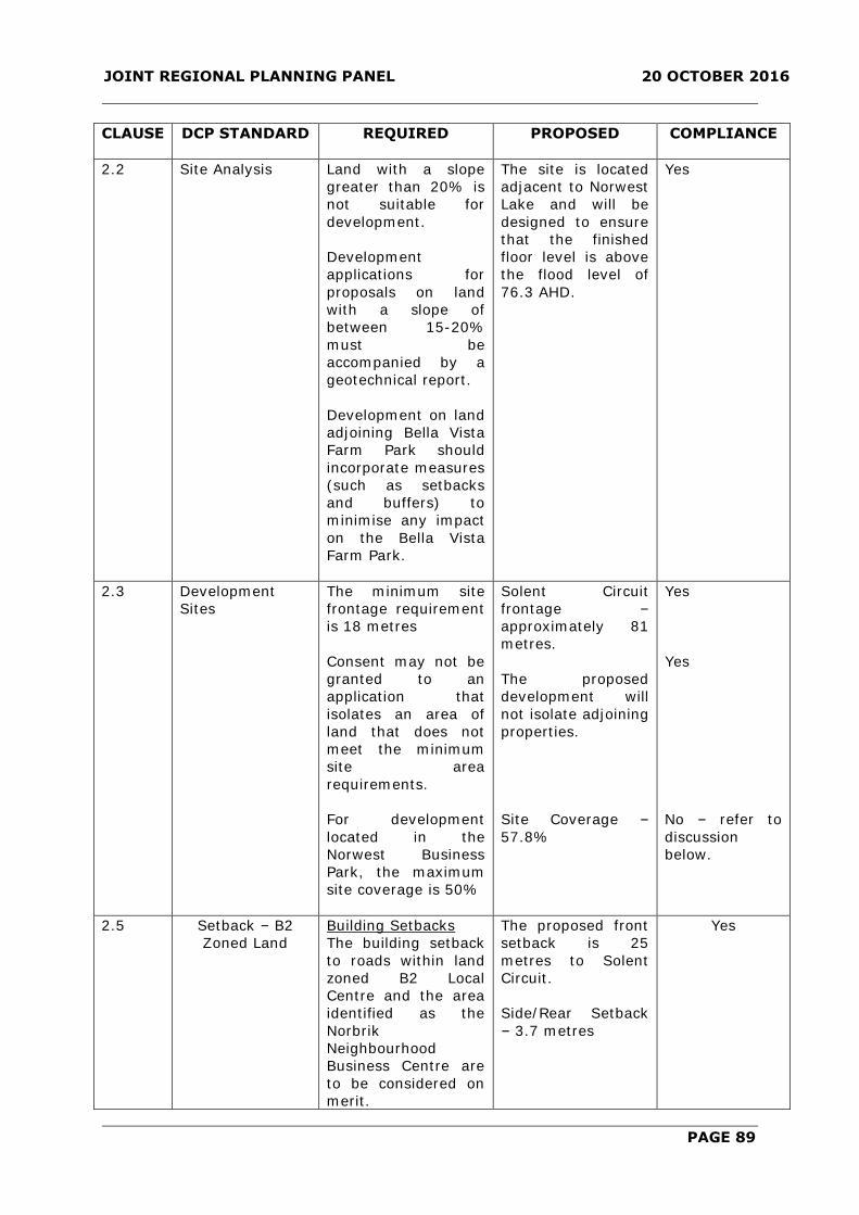
JOINT REGIONAL PLANNING PANEL 20 OCTOBER 2016
PAGE 89
CLAUSE DCP STANDARD REQUIRED PROPOSED
COMPLIANCE
2.2 Site Analysis
Land with a slope
greater than 20% is
not suitable for
development.
Development
applications for
proposals on land
with a slope of
between 15-20%
must be
accompanied by a
geotechnical report.
Development on land
adjoining Bella Vista
Farm Park should
incorporate measures
(such as setbacks
and buffers) to
minimise any impact
on the Bella Vista
Farm Park.
The site is located
adjacent to Norwest
Lake and will be
designed to ensure
that the finished
floor level is above
the flood level of
76.3 AHD.
Yes
2.3 Development
Sites
The minimum site
frontage requirement
is 18 metres
Consent may not be
granted to an
application that
isolates an area of
land that does not
meet the minimum
site area
requirements.
For development
located in the
Norwest Business
Park, the maximum
site coverage is 50%
Solent Circuit
frontage –
approximately 81
metres.
The proposed
development will
not isolate adjoining
properties.
Site Coverage –
57.8%
Yes
Yes
No – refer to
discussion
below.
2.5 Setback – B2
Zoned Land
Building Setbacks
The building setback
to roads within land
zoned B2 Local
Centre and the area
identified as the
Norbrik
Neighbourhood
Business Centre are
to be considered on
merit.
The proposed front
setback is 25
metres to Solent
Circuit.
Side/Rear Setback
– 3.7 metres
Yes

JOINT REGIONAL PLANNING PANEL 20 OCTOBER 2016
PAGE 90
Setbacks to Riparian
Corridors
Merit subject to
comments from the
relevant concurrence
authority
Norwest Lake – 2.2
metres which
relates to office
level overhang.
NSW Department of
Primary Industries
– Water provides
their concurrence.
Yes
2.7 Building Materials
All external walls of
buildings shall be
constructed of brick,
glass, pre-cast
exposed aggregate
panels of similar
material. However,
use of new materials
that generate a lower
environmental cost
will be considered on
their merits.
Balconies/terraced
areas adjacent to
residential zones
shall be suitably
screened to prevent
overlooking and
privacy impacts on
adjoining properties.
All roof ventilators,
exhaust towers and
plant equipment is
not to be visible from
the public domain
All external walls of
buildings shall be
constructed of
masonry, glass,
pre-cast exposed
aggregate panels,
steel frames, timber
cladding and stone
cladding.
Balcony areas are
suitably screened to
prevent
overlooking.
Plant and
equipment located
on the ground floor
will be partly
screened to
minimise the impact
on the public
domain.
Yes
2.8 Signage
Refer to Part C
Section 2 – Signage
of The Hills DCP
2012.
Note:
Advertisements or
business signs
erected within the
setbacks to arterial
roads are now
permitted but were
prohibited by the
preceding DCP.
To be considered
with further
Development
Applications.
Yes

JOINT REGIONAL PLANNING PANEL 20 OCTOBER 2016
PAGE 91
2.9 Hours of
Operation
24 hrs, 7 days a
week where there is
no adverse impacts
to adjoining
properties or
business.
To be considered
with further
Development
Applications.
Yes
2.12
Erosion and
Sediment Control
Erosion and
Sedimentation
Control Plans /
measures to be
considered.
Erosion and
sediment control
measures to be
recommended as a
condition of
consent.
Yes
2.13 Fencing,
No fencing other than
low ornamental type
may be erected.
Fencing along rear
boundaries adjacent
to drainage or open
space shall be
integrated with the
landscaping.
All chain-wire fencing
is to be black or dark
green.
Pre-painted solid
metal fencing is not
acceptable.
Fencing immediately
adjacent to Bella
Vista Farm Park
conservation area
shall be simple, low
level, rural type
timber construction.
The proposed
development will
not involve the
provision of any
fencing with the
exception of
boundary fencing.
Yes
Landscaping and
Tree Preservation
Grassed
embankments are
not to exceed 1:6
slopes with
vegetated
embankments
planted with soil
stabilising species at
max 1:3 grade.
Earth mounding is
desirable to mitigate
noise impacts.
Development south
of Norwest
Boulevarde shall
Retaining walls are
proposed adjacent
to the eastern and
southern boundary
to provide a
pedestrian passage
and elevated
landscaped bed
adjacent to the
boundaries.
With respect to the
levels adjacent to
Norwest Lake, the
proposed
development will
transition down
Yes
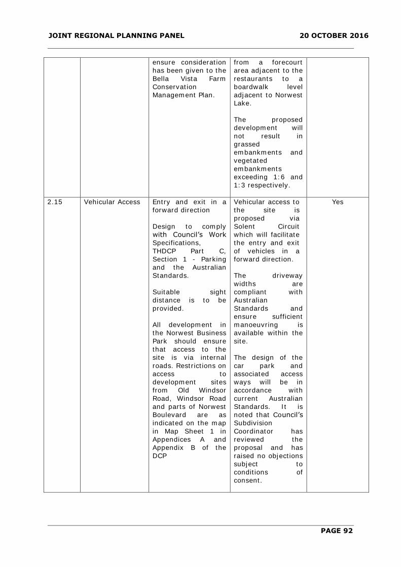
JOINT REGIONAL PLANNING PANEL 20 OCTOBER 2016
PAGE 92
ensure consideration
has been given to the
Bella Vista Farm
Conservation
Management Plan.
from a forecourt
area adjacent to the
restaurants to a
boardwalk level
adjacent to Norwest
Lake.
The proposed
development will
not result in
grassed
embankments and
vegetated
embankments
exceeding 1:6 and
1:3 respectively.
2.15 Vehicular Access Entry and exit in a
forward direction
Design to comply
with Council’s Work
Specifications,
THDCP Part C,
Section 1 - Parking
and the Australian
Standards.
Suitable sight
distance is to be
provided.
All development in
the Norwest Business
Park should ensure
that access to the
site is via internal
roads. Restrictions on
access to
development sites
from Old Windsor
Road, Windsor Road
and parts of Norwest
Boulevard are as
indicated on the map
in Map Sheet 1 in
Appendices A and
Appendix B of the
DCP
Vehicular access to
the site is
proposed via
Solent Circuit
which will facilitate
the entry and exit
of vehicles in a
forward direction.
The driveway
widths are
compliant with
Australian
Standards and
ensure sufficient
manoeuvring is
available within the
site.
The design of the
car park and
associated access
ways will be in
accordance with
current Australian
Standards. It is
noted that Council’s
Subdivision
Coordinator has
reviewed the
proposal and has
raised no objections
subject to
conditions of
consent.
Yes
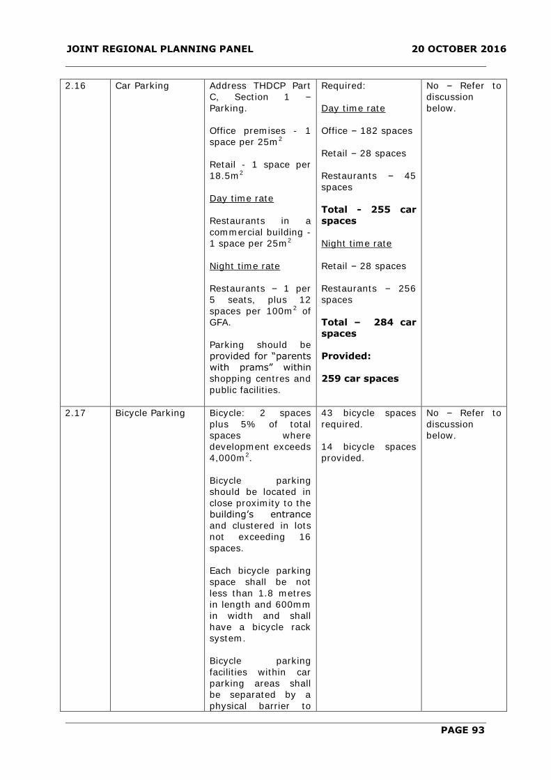
JOINT REGIONAL PLANNING PANEL 20 OCTOBER 2016
PAGE 93
2.16 Car Parking Address THDCP Part
C, Section 1 –
Parking.
Office premises - 1
space per 25m2
Retail - 1 space per
18.5m2
Day time rate
Restaurants in a
commercial building -
1 space per 25m2
Night time rate
Restaurants – 1 per
5 seats, plus 12
spaces per 100m2 of
GFA.
Parking should be
provided for “parents
with prams” within
shopping centres and
public facilities.
Required:
Day time rate
Office – 182 spaces
Retail – 28 spaces
Restaurants – 45
spaces
Total - 255 car
spaces
Night time rate
Retail – 28 spaces
Restaurants – 256
spaces
Total – 284 car
spaces
Provided:
259 car spaces
No – Refer to
discussion
below.
2.17 Bicycle Parking Bicycle: 2 spaces
plus 5% of total
spaces where
development exceeds
4,000m2.
Bicycle parking
should be located in
close proximity to the
building’s entrance
and clustered in lots
not exceeding 16
spaces.
Each bicycle parking
space shall be not
less than 1.8 metres
in length and 600mm
in width and shall
have a bicycle rack
system.
Bicycle parking
facilities within car
parking areas shall
be separated by a
physical barrier to
43 bicycle spaces
required.
14 bicycle spaces
provided.
No – Refer to
discussion
below.

JOINT REGIONAL PLANNING PANEL 20 OCTOBER 2016
PAGE 94
protect bicycles from
damage by cars,
such as curbs, wheel
stops or other similar
features.
Consideration should
be given to providing
staff change rooms
and washing
facilities.
2.18 Loading Docks Not visible from
public domain and
must provide buffer
landscaping
treatments.
Provision of loading
docks is to be
commensurate with
the size and nature
of the development
as per THDCP Part C,
Section 1 – Parking.
The loading dock
will be located
within the
basement car park
and will be
screened from
Solent Circuit
through the
provision of
landscaping.
Required: 3 loading
bays.
Provided: 2 loading
bays.
Yes
No – Refer to
discussion
below.
2.19 Pedestrian Access
and Movement
Pathways and ramps
to conform to AS
1428.1 – 2001
Design for Access
and Mobility.
All surfaces should be
stable, even and
non-slip.
Clear pedestrian
pathways are to be
indicated along
arterials road,
between
developments and
links to public
transport stations
and rail link lines
(e.g. North West Rail
Link and North West
T-way Stations).
The application was
accompanied by an
Access Review
prepared by Morris
Goding Accessibility
which confirms that
pathways and
ramps will conform
to AS1428.1.
Yes

JOINT REGIONAL PLANNING PANEL 20 OCTOBER 2016
PAGE 95
2.21 Stormwater
Management
For development in
Norwest Business
Park, two of the
measures M1 to M8
of the DCP inclusive
must be
implemented. Details
on the actions
required to
implement each of
these measures are
included in Appendix
B – Water Sensitive
Urban Design of the
DCP.
Consider satisfactory
stormwater
collection, discharge
and drainage system
design against
Council’s Work
Specifications.
Development
proposals should not
result in the filling of
flood liable land or
the erection of
buildings on flood
liable land.
Reference should be
made to the
Restriction As to User
on the title of the
land, or the
development consent
to which the
development is
proposed in relation
to requirements for
on-site detention.
The proposed
development will
involve the
discharge of
stormwater to an
on-site detention
system that
incorporates water
quality treatment
measures. The
detention system
will discharge
stormwater at a
controlled rate to
an existing drainage
easement located
within the site with
overflow to
discharge into
Norwest Lake.
Council’s
Subdivision
Coordinator has
assessed the
proposal and
concurs with the
proposed
stormwater design
and appropriate
conditions are
recommended.
Yes
2.22 Waste
Management –
Storage and
Facilities
All waste areas to be
screened from the
street and adjoining
properties.
Adequate storage for
waste materials must
be provided on site
and are not to
restrict access to
parking spaces.
Waste storage
areas are located
within the car park
area which is
enclosed and will
not be visible from
the street or
adjoining
properties. The
waste storage area
is separately
confined and will
Yes

JOINT REGIONAL PLANNING PANEL 20 OCTOBER 2016
PAGE 96
Waste storage areas
to be kept clean and
tidy.
not restrict access
to parking spaces.
2.23 Waste
Management
WMP required to be
submitted and
address demolition,
construction and
ongoing use
requirements.
The proposed
development will
involve the on-site
collection of waste
by a private waste
contractor. The
proposed waste
storage area is
located adjacent to
the loading dock
within the
basement car park
and is accessible
from Solent Circuit.
The residential units
have a dual chute
system which
enables chute
disposal of both
garbage and
recycling. The
chutes terminate in
waste rooms in the
car park area that
contain bulk bins
and linear track
conveyors. Garbage
is compacted
however recycling is
not compacted.
Residential garbage
and recycling will
both be collected
once weekly from
the holding room
adjacent to the
loading dock. A
caretaker is
responsible for
rotating bins to and
from the waste
storage areas.
There is a waste
storage area for
commercial and
retail waste.
Tenants would take
their waste direct to
their respective
area for disposal. A
Yes

JOINT REGIONAL PLANNING PANEL 20 OCTOBER 2016
PAGE 97
caretaker will be
responsible for
rotating bins to and
from the waste
storage areas and
holding rooms near
the loading dock for
collection.
Council’s Resource
Recovery Officer
has reviewed the
waste management
of the development
and has raised no
objections subject
to conditions.
2.27 Pollution Control The use of
mechanical plant and
equipment may be
restricted where sites
are located near
existing and
proposed residential
areas.
Incinerators are not
permitted for waste
disposal.
The proposed
development has
been reviewed by
Council’s
Environmental
Health Coordinator
who has considered
the potential
environmental and
acoustic impacts of
the proposed
development, and
has raised no
objection to the
proposal subject to
conditions of
consent.
Yes
2.33 11-13 Solent
Circuit
(a) Development
shall consist of a four
(4) to five (5) storey
podium containing
restaurants,
commercial uses and
car parking. Slender,
twin residential
towers shall be
placed in an offset
position atop the
podium.
The proposed
development
incorporates a 4-5
storey podium
level. The
residential towers
are relatively
slender however
the proposed
development has
incorporated a
broader floor plate
which has resulted
in the FSR
variation. The
towers are located
in an offset
position.
Yes

JOINT REGIONAL PLANNING PANEL 20 OCTOBER 2016
PAGE 98
(b) The bulk and
scale of the
development is to be
minimised through
the use of setbacks,
materials and colours
that emphasise the
podium levels rather
than upper levels
when viewed from
the surrounding area.
The bulk and scale
of the development
is considered to be
satisfactory with
regard to the
planning proposal
and the future
context of the area.
Development shall be
designed to reduce
the appearance of
bulk and scale of the
building, particularly
when perceived from
ground level, nearby
residential
development and
with consideration of
view corridors to and
from Bella Vista Farm
Park.
The bulk and scale
of the development
is sympathetic to
the site surrounds
and is not
inconsistent with
the potential bulk
and scale
earmarked on
adjoining sites as
part of the North
West Rail Link
Corridor Strategy.
Yes
Development shall be
set back from the
Solent Circuit
property boundary
by:
a minimum of 23
metres to the podium
levels; and
a minimum of 29
metres and 65
metres to each
residential tower
Podium level is
setback 24 metres.
Building B is
setback 30 metres
Building A is
setback 68 metres
It is noted that an
awning will project
beyond the main
pedestrian entry
point from Solent
Circuit and will be
setback
approximately 12
metres. The awning
is considered to be
a relatively minor
structure and
ancillary to the
building. The
awning will serve a
public benefit by
providing all
weather access to
pedestrians and will
have a minor
impact on the
streetscape.
Yes

JOINT REGIONAL PLANNING PANEL 20 OCTOBER 2016
PAGE 99
(a) Above ground
parking levels shall
be sleeved by
residential or
commercial uses or
otherwise
appropriately
screened from public
areas using
decorative screening,
green walls or
similar.
(b) Parking for the
residential and
commercial
components of the
development must be
clearly delineated.
A combination of
sandstone cladding
and perforate metal
cladding will be
used in a decorative
manner to screen
the above ground
parking levels.
Parking is clearly
delineated with
commercial and
residential spaces
being separately
confined on certain
levels.
Yes
Yes
(a) A functional,
open and high quality
landscaped setting
including seating and
shading shall be
provided at ground
level.
(b) A timber
boardwalk of at least
3 metres in width
must be maintained
or replaced along the
lake frontage of the
site.
(c) Pedestrian access
shall be provided
through the site in
accordance with the
easement for public
access shown on
Deposited Plan
1003042. This
easement is to
remain free of any
restaurant seating or
commercial use.
A high quality
landscaping area is
provided adjacent
to Norwest Lake.
The boardwalk
adjacent to the lake
will have a
minimum width of 4
metres.
The site is affected
by an easement for
public access
approximately 12
metres wide
adjacent to Norwest
Lake. It is noted
that the existing
boardwalk which
provides public
access is
approximately 3
metres wide. The
proposed boardwalk
adjacent to the lake
will be
approximately 4
metres wide.
Yes
Yes
No – refer to
discussion
below.

JOINT REGIONAL PLANNING PANEL 20 OCTOBER 2016
PAGE 100
(a) The development
must incorporate
podium level
recreational spaces
for residents
including facilities
such as a children’s
playground, pool and
terrace, gymnasium,
gardens / passive
areas, tennis court
and a club room or
similar that can
accommodate private
resident functions.
Podium level
communal open
space area provided
which includes
swimming pool,
water features,
outdoor
gymnasium, fitness
stations, an outdoor
cinema and putting
green.
Yes
Variations to the DCP have been identified and are addressed as follows:
2.7.1.1 Site Coverage
The DCP prescribes that for development located in the Norwest Business Park, the
maximum site coverage is 50%. The proposed development has a site coverage of
57.8%.
The applicant has provided the following justification:
The proposed development is generally in accordance with the FSR and building height
controls. The proposed development is suitable for the location being in close proximity
to the Norwest town centre and future station.
Comment
The proposed development provides a high quality landscaped area that will enhance the
interface and space adjacent to Norwest Lake. In addition, the proposed development
will provide a through site link which will provide the public with access to Norwest
Marketplace and to the future train station. Further, the landscaping area proposed is
strategically located to screen the lower section of the podium and to embellish the areas
adjacent to Norwest Lake. The proposed variation to site coverage is considered
satisfactory in this instance.
2.7.1.2 Car Parking
The proposed development has been assessed against the relevant commercial parking
provisions of the DCP. The proposal provides 259 commercial car parking spaces where
the DCP requires 284 car parking spaces.
The required parking rate and the provision of commercial parking are detailed in the
table below:

JOINT REGIONAL PLANNING PANEL 20 OCTOBER 2016
PAGE 101
Parking Type Required Day
Time
Required Night
Time (Post
6:30pm) and
Weekend
Proposed Day
Time
Proposed
Night Time
and
Weekend
Office 182 - 182 -
Retail 28 28 28 34
Restaurants 45 256 49 225
Total 255 284 259 259
The applicant has provided the following justification:
At night time and weekend, the restaurants would require 256 parking spaces. During
those periods, offices are generally closed or operate with much reduced staff levels. It
would therefore be appropriate for the restaurants patrons and staff to have access to
the spaces for commercial developments during the evenings and weekends.
The 259 commercial spaces will be provided in the basement and ground floor levels. At
night time and weekend, the restaurants would require about 255 parking spaces. As
discussed above, these spaces would become available for restaurants patrons and staff
during the evenings and weekends. It would be also reasonable to assume that about 10
to 15 percent of restaurant patrons would be residents walking from either the proposed
development or from nearby residential developments in Norwest thus would not require
parking.
A separate Carpark Management Report has been prepared by InterPark to address the
use and management of the carparks and should be referred to in relation to these
arrangements.
Comment
The proposed development results in a shortfall of 25 commercial car parking spaces
when adopting a dual use parking rate as detailed in the table above.
The applicant has sought a variation to the car parking provision on the premise that the
parking provided for the office component will be surplus to needs during peak dining
periods and that these spaces could be utilised under a dual use arrangement for
restaurant tenancies between 6:30pm to midnight on weeknights and during the
weekend.
Furthermore, the applicant has advised that parking for the retail component will also be
surplus to needs after 6:30pm on weekdays and during weekends. Based on this
approach, the applicant asserts that the proposed reallocation of retail parking spaces for
restaurant use will result in the proposed development complying with the parking
provision, specifically for the restaurant component. However, the reallocation of the 28
spaces for the restaurant component during peak dining periods cannot be supported
given that the operational nature of the retail tenancies is unknown at this stage. It is
acknowledged that the location of the site and the nature of the retail floor plates are
likely to result in retail uses that are non-destinational in nature however this would be
subject to further consideration with a subsequent Development Application.
Nevertheless, it is considered that the variation of 25 car parking spaces is satisfactory.
The parking layout has been designed in a manner where the basement level which
comprises of 176 car parking spaces will be exclusively used by office tenancies during
the weekday until 6:30pm. The ground floor level will comprise of 83 car parking spaces
and will be exclusively used at all times by the retail and restaurant component which is

JOINT REGIONAL PLANNING PANEL 20 OCTOBER 2016
PAGE 102
adequate for weekday hours. Thereafter, parking on the basement level will be freely
accessible to retail and restaurants between 6:30pm to midnight on weekdays and
weekends. To ensure the dual use arrangement will be implemented, conditions of
consent are recommended to ensure that a positive covenant is placed on title which
requires the basement car parking spaces to be accessible to restaurants and retail
between 6:30pm to midnight during weeknights and on weekends.
To support this arrangement, a Carpark Management Report prepared by Interpark
accompanies the Development Application which sets out the operational parameters for
the dual use arrangement. Compliance with the Carpark Management Report will be
recommended as a condition of consent.
Based on the proposed dual use arrangement, the proposed parking variation is
considered to be acceptable given that there will be an adequate supply of parking at all
times based on the differing operational peak usage periods of the commercial
component. In this regard, a variation can be supported.
2.7.1.3 Bicycle Parking
The proposed development generates a requirement for 43 bicycle parking spaces. The
proposed development provides for 14 bicycle parking spaces, which represents a
shortfall of 29 spaces.
The applicant has provided the following justification:
The core objective for the provision of bicycle parking is to reduce dependence on motor
vehicles and encourage the use of cycling for every day trips such as visiting
shops/groceries and also for commuting. However, the subject site is located within a
mixed use precinct with immediate access to shops and supermarkets which can be
accessed for walking. Similarly, the site is within extremely close proximity to the
forthcoming train station which will meet the commuting needs of future residents and is
also within the major Norwest employment precinct such that some residents will likely
also walk to work.
Having regard to the above, it is considered unnecessary for such a high provision of
bicycle parking to be provided at the subject site and the objectives are met by the
capacity of residents to walk to the nearby facilities. Notwithstanding, it is noted there
are 104 storage cages for the apartments which are of sufficient size that they could
accommodate a bicycle for recreational use.
Comment
The proposed bicycle provision of 14 spaces is considered to be satisfactory given the
proximity and walking distance to Norwest Marketown, future Norwest Station and the
proximity to places of employment in the Norwest Business Park. Additionally, the
applicant has indicated that at least 90 storage areas located within the car park have
the capacity to accommodate the storage of bicycles. In this regard, a variation is
considered to be satisfactory.
2.7.1.4 Loading Docks
The proposed development is required to provide 3 loading bays in accordance with the
DCP. The proposed development provides 2 loading bays.
The applicant has provided the following justification:

JOINT REGIONAL PLANNING PANEL 20 OCTOBER 2016
PAGE 103
A loading facility will be provided on the western side of the development near the
garbage holding room as shown in DN 110—010 of Appendix A. It will consist of two
loading bays which could accommodate simultaneously a large rigid truck and a medium
rigid truck. Trucks would enter the site in a forward direction than reverse into the
loading area before exiting the site in a forward direction. The swept paths of trucks
accessing the loading area are included in Appendix B. The proposed loading area
complies with the Australian Standards for heavy vehicles (2002).
These two loading bays will most likely be used by garbage trucks and removals trucks
when the building starts to get occupied. This number is adequate to accommodate
trucks for the proposed type of development.
Most of the offices and restaurants would be serviced by van and courier type vehicles.
Three such spaces have been designated in the ground floor near the office lobby and
restaurants. These spaces have been designed with additional heights to accommodate
such vans.
Comment
The proposed development will comprise 36 office tenancies which vary in size from
66m2 to 188m2. As a result of the cumulative floor area of the office component, the DCP
would require 3 loading bays. In this instance, the provision of 3 loading bays is
considered to be surplus to needs given the relatively small floor plates for each tenancy.
The two proposed loading areas are likely to adequately accommodate the loading and
unloading of goods for future office tenancies. It is also noted that the proposed
development also provides for three designated loading and unloading spaces specifically
for restaurant and retail uses on the ground floor. In this regard, a variation is
considered to be satisfactory.
2.7.1.5 Pedestrian Access
The DCP requires that pedestrian access be provided through the site in accordance with
the easement for public access shown on Deposited Plan 1003042. This easement is to
remain free of any restaurant seating or commercial use. The easement for public access
is approximately 12 metres wide and runs parallel to Norwest Lake. The proposed
development will result in the encroachment of outdoor dining within the easement at
ground level in addition to building overhang for the office component above.
The existing timber boardwalk adjacent to Norwest Lake is approximately 3 metres wide.
The proposed development seeks to improve the boardwalk which will result in the
widening of the boardwalk to a minimum width of 4 metres. Accordingly, the principal
purpose of the public access easement is being maintained in that public pedestrian
access is being facilitated.
Additionally, the applicant has supported the improvements to the boardwalk with the
submission of a Public Space Analysis prepared by JBA. The analysis indicates that the
width of the boardwalk exclusive of the area used for outdoor dining is satisfactory and
is capable of accommodating pedestrian foot movements through the site. In this
regard, the encroachment of the outdoor dining area into the public access easement will
not detract from the ability of the boardwalk to accommodate pedestrian movements.
In this regard, a variation to the DCP and a departure from the terms of the deposited
plan in accordance with Clause 1.9A of the LEP is considered to be satisfactory.

JOINT REGIONAL PLANNING PANEL 20 OCTOBER 2016
PAGE 104
2.7.2 Part B Section 5 – Residential Flat Buildings
Part B Section 5 Residential Flat Buildings applies to land where residential flat buildings
are permissible. This is a mixed use development with a residential flat building
component. The DCP contains provisions which typically apply in residential zones where
the maximum height limit is in the order of four storeys. In this regard, this particular
section of the DCP has been used as a guide to assess the residential component of the
development noting that the site is subject to site-specific LEP height and FSR controls
and provisions under DCP Part B Section 6 – Business.
The proposal has been assessed against the relevant controls of Part B Section 5 –
Residential Flat Building as detailed in the table of compliance below.
DEVELOPMENT
STANDARD
(CLAUSE NO.)
BHDCP
REQUIREMENTS
PROPOSED
DEVELOPMENT
COMPLIANCE
3.1 Site
Requirements
The minimum lot size for
residential flat buildings is
specified in Clause 4.1A of The
Hills Local Environmental Plan
2012, as follows:
Within:
R1 General Residential –
4,000m2
R4 High Density Residential –
4,000m2
B2 Local Centre – 4,000m2
B4 Mixed use – 4,000m2
Min. road frontage – 30m
A residential flat building shall
not isolate adjoining lots so
that they are incapable of multi
dwelling housing development,
meaning there will be sufficient
area to meet the minimum site
area requirement in Clause
4.1A Minimum lot sizes for dual
occupancy, multi dwelling
housing and residential flat
buildings of the LEP 2012.
12,000m2
Solent Circuit
frontage –
Approximately 81
metres.
Adjoining
properties will not
be isolated.
Yes
Yes
Yes
3.5 Building
Separation and
Treatment
12m Separation
distance between
Building A and B –
26 metres.
Yes
3.6 Landscaped
Area
50% of site area
42% of site area is
landscaped.
No – refer to
discussion
below.

JOINT REGIONAL PLANNING PANEL 20 OCTOBER 2016
PAGE 105
3.7 Building
Length
Max. 50m
Building A – 50
metres
Building B – 51
metres
No – refer to
discussion
below.
3.8 Building
Design and
Streetscape
Must refer to Council’s “Multi-
Unit Housing: Urban Design
Guidelines 2002”
Designs must be in harmony in
terms of form, mass, colour
and structure with existing and
likely future development in the
street.
Siting and design to ensure
clear definition of street edge
and reinforce street corners.
Building lines together with
landscaping treatments should
distinguish the public and
private realms.
Must not be repetitive in design
and incorporate harmonious
design variations such as
verandas, entrances, facades,
etc.
Walls and Rooflines:
- Articulation provided to
reduce bulk
- With variety of colours to
reduce monotony and add
enhance the streetscape
- With windows to enhance
façade appearance
- Well balanced vertical and
horizontal proportions
- Break up large horizontal
facades (whether walls or
roofs) into smaller sections
no longer than 10m
- Use of well-proportioned and
balanced projections and
recesses on facades.
The proposal is
consistent with the
Multi-Unit
Housing: Urban
Design Guidelines
2002.
The proposed
design of the
development is
considered to be
in harmony with
respect to the
form, mass,
colours and
finishes of existing
and likely future
development.
The siting of the
building,
predominately to
the alignment of
the street and
Norwest Lake and
will reinforce
public interfaces.
The form of the
development
results in a
harmonious
design. Block A
and B will
comprise of
distinguishing
massing and
features that will
not result in a
mirroring effect of
the buildings.
The proposed
façades of the
development
fronting Solent
Circuit and
Norwest Lake
comprise of high
quality materials
Yes

JOINT REGIONAL PLANNING PANEL 20 OCTOBER 2016
PAGE 106
- Provision of architectural
features in the façade such
as entry porches, pergolas,
etc.
Garages:
- Comprise more than one
material and colour to
enhance visual attractiveness
and interest.
- Concealed or screened by
planting from the street and
public view, as much as
possible.
Entrances:
- Clearly visible from the
public and semi-public areas.
Lighting to be provided for
safety at night.
- Entries to be readily
apparent from the street and
clearly visible from inside the
dwelling for casual
surveillance.
- Space around building
entrance to be sufficiently large to stand out and have a
distinctive architectural form.
- Entries to be distinctive,
attractive and welcoming.
- Provide sheltered transitional
areas around building
entries.
- All ground floor dwellings to
have their own entry at
ground level.
- Building entries to be visible
from, or address the site
front boundary, and clearly
delineated and observable
from the driveway.
Views and Siting:
- Siting of building to take
advantage of any views to
nearby/adjoining landscaped
open space or any public
reserve.
- Siting and design to take
advantage of any views to
and finishes. A
mixture of
sandstone
cladding, metallic
cladding, ceramic
tile cladding and
glazing will be
incorporated into
the design of the
facades.
The proposed
development will
comprise of a
basement garage
and parking will be
predominately
concealed from
public view.
The main entries
into the central
colonnade is
clearly visible from
Solent Circuit and
will be defined by
a projecting
awning. The
entries are
suitably
articulated and are
identifiable to
residents and
visitors.
The siting of the
proposed built
form responds to
the ridge setting
of the site and
takes advantages
of views in all

JOINT REGIONAL PLANNING PANEL 20 OCTOBER 2016
PAGE 107
open space, public reserves
and bushland to promote
natural surveillance and
enhance visual amenity for
residents.
- Avoid blank courtyard walls
along boundaries shared with
open space or reserves.
- Provide opportunities to
create and orient dwellings
to permit direct views from
living areas into the open
space/reserve.
- Avoid courtyards facing a
street or public place. If
cannot be avoided due to
design constraints, design to
comply with Section 3.27
Fencing giving consideration
to streetscape and visual
impact issues.
directions given
the elevation of
the buildings. The
orientation of
living spaces and
balconies within
the development
will promote the
natural
surveillance of the
central plaza.
3.9 Urban Design
Guidelines
Demonstrate conformity with
“Baulkham Hills Multi Unit
Housing – Urban Design
Guidelines 2002"
The proposal is
consistent with the
Multi-Unit
Housing: Urban
Design Guidelines
2002.
Yes
3.10 Density 150-175 persons per hectare
428 persons per
hectare.
No – refer to
discussion
below.
3.11 Unit Layout
and Design
Apartment Mix
(a) No more than 25% of the
dwelling yield is to comprise
either studio or one bedroom
apartments.
(b) No less than 10% of the
dwelling yield is to comprise
apartments with three or more
bedrooms.
Residential Flat Development
(30 or more units) (d) The
minimum internal floor area for
each unit, excluding common
passageways, car parking
spaces and balconies shall not
be less than the following:
Complies. A
maximum of 14%
of units are 1
bedroom
Complies. 12.9%
of units are 3
bedroom
Yes
Yes

JOINT REGIONAL PLANNING PANEL 20 OCTOBER 2016
PAGE 108
Apartment Size
Category Apartment
Size
Type 1
1 Bedroom 50m2
2 Bedroom 70m2
3 or more Bedrooms 95m2
Type 2
1 Bedroom 65m2
2 Bedroom 90m2
3 or more Bedrooms 120m2
Type 3
1 Bedroom 75m2
2 Bedroom 110m2
3 or more Bedrooms 135m2
Type 1 apartments shall not
exceed 30% of the total
number of 1, 2 and 3 bedroom
apartments.
Type 2 apartments shall not
exceed 30% of the total
number of 1, 2 and 3 bedroom
apartments.
All remaining apartments are to
comply with the Type 3
apartment sizes.
80% of units are
type 1.
17% of units are
type 2.
3% of units are
type 3.
No – refer to
discussion
below.
Yes
No – refer to
discussion
below.
3.12 Building
Materials
Must comply with the Local
Government Act, 1993, Local
Government regulations and
Building Code of Australia
Reflect and complement the
existing character and
streetscape.
Choice of materials to consider
both their environmental and
economic costs.
Use graffiti resistant materials
in areas accessible by the
general public and communal
areas within the development.
A condition of
consent will be
imposed to ensure
compliance with
the Building Code
of Australia.
The proposed
materials, colours
and finishes will
complement the
existing
streetscape and
desired future
character.
The selection of
materials
considers both
environmental and
economic costs.
Where possible,
graffiti resistant
materials will be
used as
recommended by
the NSW Police.
Yes
Yes
Yes
Yes

JOINT REGIONAL PLANNING PANEL 20 OCTOBER 2016
PAGE 109
Use colours that are visually
pleasing and reflect the
predominant colours in the
area.
Avoid materials and colours
with excessive glare.
Avoid materials that are likely
to contribute to poor internal
air quality.
Select materials that will
minimise the long-term
environmental impact over the
whole life of the development.
Preference to materials derived
from renewable sources or are
sustainable and generate lower
environmental cost, recycled
material/s with low embodied
energy, better lifecycle costs
and durability.
The colour
selection is
reflective of a
modern
development in
the Business Park.
The standard of
glazing will be
determined at the
Construction
Certificate stage
and will be
compliant with
Australian
Standards so as to
minimise the
effect of glare.
The selection of
materials will not
result in poor
internal air
quality.
The material
selection is
considered to
afford the built
form with
longevity.
The selection of
materials is
considered to
provide for
satisfactory
thermal comfort
and durability.
Yes
Yes
Yes
Yes
Yes
3.13 Open Space Private:
Ground level – 4m x 3m (min)
Above ground – min. 10m2 with
min. depth 2.5m
Common: 20m2 per dwelling
Podium level
private open space
areas comply.
Minimum 8m2 with
min. depth of 2m
4,940m2 of
common open
space area.
Yes
No – refer to
discussion
below.
No – refer to
discussion
below.

JOINT REGIONAL PLANNING PANEL 20 OCTOBER 2016
PAGE 110
3.14 Solar Access Adjoining buildings / open
space areas – 4 hours between
9am and 3pm on 21 June
Common open space – 4 hours
between 9am and 3pm on 21
June
Adjoining
residential
properties will
receive 3 hours of
solar access
between 9am and
3pm on 21 June.
Yes
3.15 Ventilation - Consider prevailing breezes in
relation to building orientation,
window design and internal
circulation.
- Place windows to allow for
cross ventilation i.e. on
opposite sides of the building
rather than adjacent walls
where possible. These windows
are to be lockable in a partly
open position.
- Promote air circulation and
consider the installation of
fans, roof vents, louvered
windows and high-level
windows to aid air circulation.
The proposed
orientation and
internal
configuration of
the development
responds to
prevailing breezes
in order to
maximise natural
ventilation to
apartments. At
least 60.8% of
apartments are
naturally
ventilated which
exceeds the 60%
requirement of the
ADG.
Windows have
been located on
opposite sides or
to a different
aspect where
possible.
The proposed
development will
provide for
sufficient air
circulation to
apartments and
common areas.
Yes
Yes
Yes
3.16 Lighting - Lighting to be in accordance
with the Building Code of
Australia.
- Adequate lighting to ensure
the security and safety of
residents and visitors.
A condition of
consent will be
imposed to ensure
compliance with
the Building Code
of Australia.
Adequate lighting
will be provided
for the safety and
security of
residents.
Yes
Yes
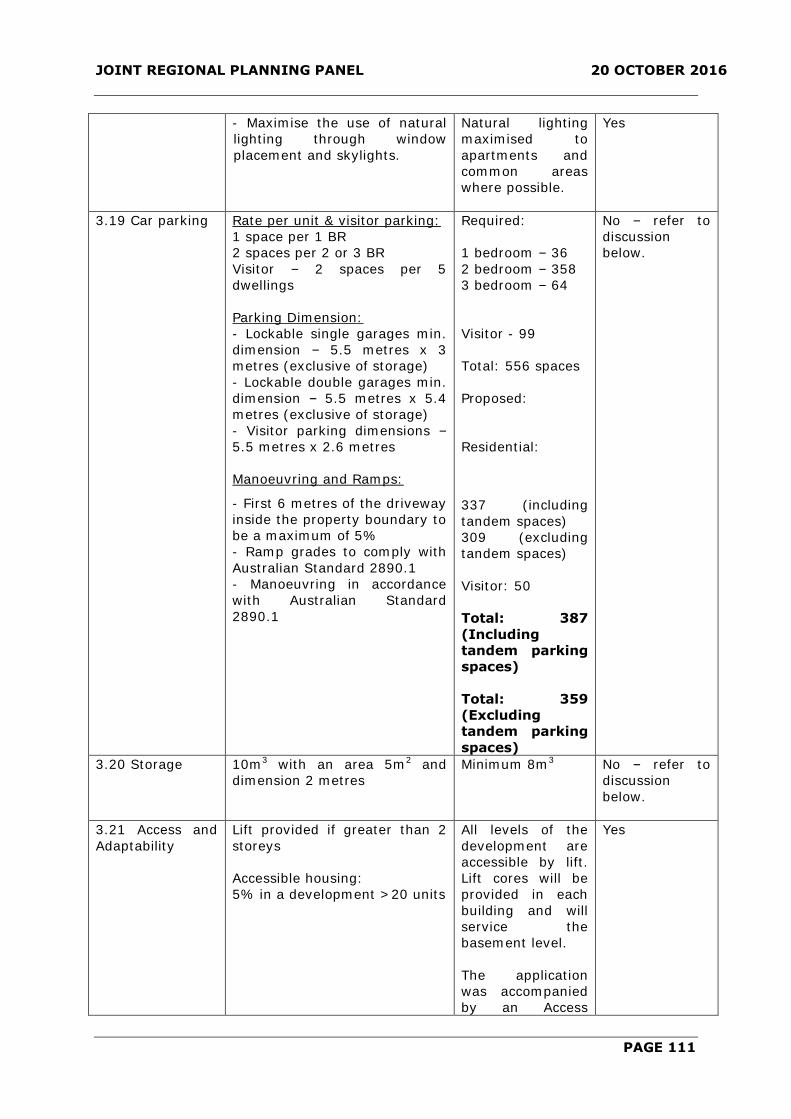
JOINT REGIONAL PLANNING PANEL 20 OCTOBER 2016
PAGE 111
- Maximise the use of natural
lighting through window
placement and skylights.
Natural lighting
maximised to
apartments and
common areas
where possible.
Yes
3.19 Car parking Rate per unit & visitor parking:
1 space per 1 BR
2 spaces per 2 or 3 BR
Visitor – 2 spaces per 5
dwellings
Parking Dimension:
- Lockable single garages min.
dimension – 5.5 metres x 3
metres (exclusive of storage)
- Lockable double garages min.
dimension – 5.5 metres x 5.4
metres (exclusive of storage)
- Visitor parking dimensions –
5.5 metres x 2.6 metres
Manoeuvring and Ramps:
- First 6 metres of the driveway
inside the property boundary to
be a maximum of 5%
- Ramp grades to comply with
Australian Standard 2890.1
- Manoeuvring in accordance
with Australian Standard
2890.1
Required:
1 bedroom – 36
2 bedroom – 358
3 bedroom – 64
Visitor - 99
Total: 556 spaces
Proposed:
Residential:
337 (including
tandem spaces)
309 (excluding
tandem spaces)
Visitor: 50
Total: 387
(Including
tandem parking
spaces)
Total: 359
(Excluding
tandem parking
spaces)
No – refer to
discussion
below.
3.20 Storage 10m3 with an area 5m2 and
dimension 2 metres
Minimum 8m3 No – refer to
discussion
below.
3.21 Access and
Adaptability
Lift provided if greater than 2
storeys
Accessible housing:
5% in a development >20 units
All levels of the
development are
accessible by lift.
Lift cores will be
provided in each
building and will
service the
basement level.
The application
was accompanied
by an Access
Yes

JOINT REGIONAL PLANNING PANEL 20 OCTOBER 2016
PAGE 112
Review prepared
by Morris Goding
Accessibility which
confirms that 14
or 6% of units will
be accessible.
A condition of
consent is to be
recommended to
ensure that the
proposed
development is
consistent with the
methodology of
the Access
Review.
3.22
Pedestrian/Bicycle
Links
Within the Site
- Access to dwellings should be
direct and without unnecessary
barriers. No steps between the
street frontage and the
principal building entrances.
- Provide clearly defined
pedestrian pathways between
proposed development and
proposed footpaths along sub-
arterial roads.
- Adequate lighting in common
and access areas.
- All pathways and ramps to
conform to the minimum
dimensional requirements set
out in AS1428 Part 1-1998
Design for Access and Mobility
and AS1428 Part 2–1992. and
Council’s Policy “Making Access
for All” (2002).
- All surfaces to be stable, even
and constructed of slip
resistant materials. Any stair
nosings should have a
distinctive colour and texture.
Access will be
provided at-grade
to Solent Circuit.
Internal pathways
within the
development will
be clearly defined
as detailed on the
Landscape Plan.
Adequate lighting
to be provided to
common open
areas.
All access paths
and ramps are to
comply with
relevant Australian
Standards.
All surfaces will be
stable and even to
provide for safe
pedestrian
passage.
Yes
Yes
Yes
Yes

JOINT REGIONAL PLANNING PANEL 20 OCTOBER 2016
PAGE 113
- Building and unit numbering
and all signage is to be clear
and easy to understand.
International Symbols of
Access should be displayed
where buildings, crossings,
amenities, car parking,
pathways and ramps are
accessible, as detailed in the
The Hills Shire Council policy
entitled “Making Access For All”
(2002).
- Pathway locations must
ensure natural surveillance of
the pathway from primary
living areas of adjoining units.
Dwelling entries must not be
hidden from view and must be
easily accessible.
- A bicycle lockup facility to be
provided close to the main
entry to the building.
Local Pedestrian Links
- Where possible, a pedestrian
link through the site must be
provided as part of the
development to increase the
connectivity of the area for
local pedestrians. The following
factors should be considered
when identifying the most
appropriate location for the link
of the pathway:
- The link must be no less
than 3m wide;
- Should be a straight-line
link through the site linking
streets or other public
spaces; and
- Cannot include stairs and
any ramps. Must have a
reasonable gradient - refer
to AS 1428.1 - 1988 Design
for Access and
- The design and layout of
any building adjoining and
landscaped spaces adjoining
the pathway should ensure
there is natural surveillance
of the pathway to protect
Signage and unit
numbering will be
clear and legible.
Apartments are
orientated to
ensure the natural
surveillance of
public and
communal areas.
Bicycle lockup and
storage provide
adjacent to the lift
core within the
basement car
park.
A through
pedestrian site link
adjacent to
Norwest Lake is
provided within
the site to
promote
pedestrian
connectivity.
The boardwalk will
be a minimum
width of 4 metres
and will comprise
of a relatively
uniform level.
The link will be
surrounded with
suitable
landscaping and is
designed to
promote natural
surveillance.
Yes
Yes
Yes
Yes
Yes

JOINT REGIONAL PLANNING PANEL 20 OCTOBER 2016
PAGE 114
the amenity of users. A solid
fence along the boundary of
the pathway restricting
views of the pathway from
adjoining properties not
acceptable.
3.23 Privacy –
Visual and
Acoustic
- Minimise direct overlooking of
main internal living areas and
private open space of dwellings
both within and adjoining the
development through building
design, window locations and
sizes, landscaping and
screening devices (refer to
section 3.13 Open Space)
- Consider the location of
potential noise sources within
the development such as
common open space, service
areas, driveways, and road
frontage, and provide
appropriate measures to
protect acoustic privacy such
as careful location of noise-
sensitive rooms (bedrooms,
main living areas) and double
glazed windows.
Units have been
designed to
minimise the
potential for direct
overlooking
through the
sufficient
separation of
Building A and B
in addition to the
appropriate
placement of
balconies and
windows.
Furthermore,
given that the site
is isolated and
combined with the
substantial
distance to
adjoining
residential
properties, the
proposal will not
result in undue
overlooking into
adjoining
residential
properties.
The internal
configuration of
the development
has been designed
to consider the
location of
potential noise
sources.
The Development
Application was
accompanied by
an Acoustic
Report. The report
identifies the main
noise sources
including
mechanical plant
Yes
Yes

JOINT REGIONAL PLANNING PANEL 20 OCTOBER 2016
PAGE 115
equipment and
traffic noise
associated with
vehicular traffic
generated by the
proposed
development. The
report concludes
that the level of
noise emitted by
the proposed
development will
meet the noise
level requirements
of the NSW
Environmental
Protection
Authority (EPA)
subject to the
implementation of
noise mitigation
measures.
3.24 Services - Development consent not to
be granted until satisfactory
arrangements are made with
relevant authorities for the
provision of services.
- Site services and facilities
(such as letterboxes, clothes
drying facilities and garbage
facility compounds shall be
designed so as:
- To provide safe and
convenient access by
residents and the service
authority; and
- Visually integrated with the
development and have
regard to the amenity of
adjoining development and
streetscape.
- Laundries shall be provided to
each dwelling.
A condition of
consent will be
imposed to ensure
satisfactory
arrangements are
made with the
relevant service
authorities for the
provision of
services.
Services and
facilities for
residents and
visitors have been
designed for safe
and convenient
access.
Each apartment
will be provided
with an internal
laundry.
Yes
Yes
Yes

JOINT REGIONAL PLANNING PANEL 20 OCTOBER 2016
PAGE 116
3.25 Waste
Management –
Storage and
Facilities
- Waste collection and
separation facilities to
be provided for each
dwelling. Each dwelling
should have a waste
storage cupboard in
the kitchen capable of
holding at least a
single days waste, and
sufficient to enable
separation of
recyclable material.
- Adequate storage for
waste materials must
be provided on site
and any such waste
must be removed at
regular intervals and
not less frequently
than once per week for
garbage and fortnightly
for recycling.
- Screen views of
waste and storage
facility from any
adjoining property or
public place while
ensuring there is some
natural surveillance
from within the
development to
minimise vandalism
and other anti-social
activity.
- Waste storage areas
to be kept clean, tidy
and free from offensive
odours at all times.
Communal waste
storage area
proposed within car
parking area.
No objections
received by Council’s
Resource Recovery
Officer and conditions
provided accordingly.
Yes
3.26 Waste
Management
Planning
Submission of a Waste
Management Plan –
demolition,
construction and on-
going use.
No objections
received by Council’s
Resource Recovery
Officer and conditions
provided accordingly.
Yes
Variations to the DCP have been identified and are addressed as follows:
2.7.2.1 Landscaping
The DCP requires a minimum landscaped area which equates to 50% of the site area.
The proposed development will provide a landscaped area of 42%.
The applicant has provided the following justification:

JOINT REGIONAL PLANNING PANEL 20 OCTOBER 2016
PAGE 117
The subject site is located predominantly within the B2 Local Centre zone pursuant to
the Hills Local Environmental Plan 2012 with a core objective to provide a range of retail,
business, entertainment and community uses that serve the needs of people who live in,
work in and visit the local area.
Part B of the DCP relates to residential flat buildings and whilst it applies to the subject
site, its application also applies to any residential flat building throughout the local
government area in areas which are not within a local centre. The existing site does not
provide 50% landscaping and the context of the site is characterised as an urban centre
where such a landscaping provision is inconsistent with this character. The proposed
development is in fact for a mixed use development with a substantial commercial
component and Objective 4S-2 of the Apartment Design Guide provides that Landscaped
communal open space should be provided at podium or roof levels whilst Objective 3E-1
in relation to deep soil provides that deep soil may not be possible where there are non-
residential uses at ground floor.
Notwithstanding this, the proposal still provides a substantial amount of landscaping on
the site being 42% and satisfies the objective for landscaping within the DCP to provide
a satisfactory relationship between buildings, landscaping areas and adjoining
developments. Given the context of the site within a local centre the provision of
landscaping is considered capable of support.
Comment
The site is located within what is essentially a business zone within the Norwest Business
Park. The landscape control typically applies to residential flat developments proposed in
suburban zones. Nevertheless, the proposed development provides a high quality
landscaped area that will enhance the interface and space adjacent to Norwest Lake. In
addition, the proposed development will provide a through site link which will provide the
public with access to Norwest Marketplace and to the future train station. Further, the
landscaping area proposed is strategically located to screen the lower section of the
podium and to embellish the areas adjacent to Norwest Lake.
In this regard, a variation is considered to be satisfactory.
2.7.2.2 Building Length
The DCP limits the length of buildings to a maximum of 50 metres. Building B will have a
building length of approximately 51 metres.
The applicant has submitted the following justification:
Building A does not exceed 50 metres in length. The northern portion of Building B
marginally exceeds 50m by approximately 1m however this is due to the balcony on the
eastern side. Given the particularly minor nature of the exceedance and having regard to
the highly modulated nature of the buildings and curved ends which diminish the
perceived length of the facades, the proposed development is considered to represent an
appropriate bulk and scale with respect to building length.
Comment
The objective of the control is to minimise the bulk and scale of the building and to
ensure each unit achieves good residential amenity. The perceived bulk and scale of the
development is considered to be satisfactory given that the building is sufficiently
articulated and adopts a curvature form on the edges of the building.

JOINT REGIONAL PLANNING PANEL 20 OCTOBER 2016
PAGE 118
The units are also considered to respond appropriately to the objectives regarding
amenity. Unit sizes are larger than required with functional floor layouts. Units will
receive adequate solar access, natural ventilation and will capitalise on views to Norwest
Lake. It is also noted that the proposed length will not result in adverse shadowing
impacts to residential properties in proximity to the site.
2.7.2.3 Density
The DCP prescribes a maximum density of 150-175 persons per hectare. The proposed
development will result in a density of 428 persons per hectare.
The applicant has provided the following justification:
The proposed development is in accordance with the planning proposal supporting the
LEP amendment no.29 and Council’s strategic planning for mixed use on the site. The
increase in density is not precluded by the VPA. The density is suitable for the location
being in close proximity to the new Norwest train station.
Comment
The site has been the subject of a Planning Proposal which determined that a higher
form of density was appropriate for the site and earmarked a dwelling yield in the order
of 240 units. Accordingly, the site is subject to a floor space ratio which would result in a
density that would significantly exceed 150-175 persons per hectare. The floor space
ratio control is considered to be a more appropriate mechanism to regulate the density
of the development.
It is noted that the site is located within what is essentially a business zone within the
Norwest Business Park. The density control typically applies to residential flat
developments proposed in residential zones where there is no floor space ratio standard.
Furthermore, it should be noted that the control applies to residential flat development
that would typically be restricted to a maximum height of 4 storeys.
In this regard, the proposed development is considered to be of a suitable density given
its location within the Norwest Business Park and its proximity to future Norwest Station.
2.7.2.4 Private Open Space
The DCP requires that private open spaces above ground floor comprise a minimum of
10m2 with minimum depth 2.5 metres. The proposed development will include balconies
that are 8m2 with minimum depth 2 metres.
The applicant has submitted the following justification:
The majority of the units comply with 6 units under the 10m² ranging by some 1-2m².
This is a minor variation, adequate balcony sizes are provided. Complies with SEPP
No.65 provisions.
Comment
The private open space areas comply with the requirements of the Apartment Design
Guidelines which specify a minimum area of 8m2 for one bedroom units. Additionally, the
proposed development provides for a high level of residential amenity with over 70% of
private open space areas receiving 2 hours of solar access during mid-winter.
Furthermore, the communal open space area provides for both passive and recreational
activities. In this regard, a variation is considered to be satisfactory.
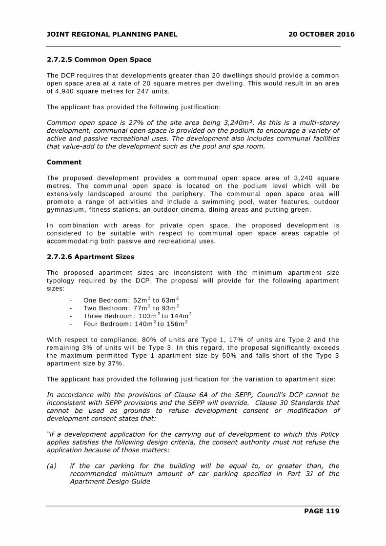
JOINT REGIONAL PLANNING PANEL 20 OCTOBER 2016
PAGE 119
2.7.2.5 Common Open Space
The DCP requires that developments greater than 20 dwellings should provide a common
open space area at a rate of 20 square metres per dwelling. This would result in an area
of 4,940 square metres for 247 units.
The applicant has provided the following justification:
Common open space is 27% of the site area being 3,240m². As this is a multi-storey
development, communal open space is provided on the podium to encourage a variety of
active and passive recreational uses. The development also includes communal facilities
that value-add to the development such as the pool and spa room.
Comment
The proposed development provides a communal open space area of 3,240 square
metres. The communal open space is located on the podium level which will be
extensively landscaped around the periphery. The communal open space area will
promote a range of activities and include a swimming pool, water features, outdoor
gymnasium, fitness stations, an outdoor cinema, dining areas and putting green.
In combination with areas for private open space, the proposed development is
considered to be suitable with respect to communal open space areas capable of
accommodating both passive and recreational uses.
2.7.2.6 Apartment Sizes
The proposed apartment sizes are inconsistent with the minimum apartment size
typology required by the DCP. The proposal will provide for the following apartment
sizes:
- One Bedroom: 52m2 to 63m2
- Two Bedroom: 77m2 to 93m2
- Three Bedroom: 103m2 to 144m2
- Four Bedroom: 140m2 to 156m2
With respect to compliance, 80% of units are Type 1, 17% of units are Type 2 and the
remaining 3% of units will be Type 3. In this regard, the proposal significantly exceeds
the maximum permitted Type 1 apartment size by 50% and falls short of the Type 3
apartment size by 37%.
The applicant has provided the following justification for the variation to apartment size:
In accordance with the provisions of Clause 6A of the SEPP, Council’s DCP cannot be
inconsistent with SEPP provisions and the SEPP will override. Clause 30 Standards that
cannot be used as grounds to refuse development consent or modification of
development consent states that:
“if a development application for the carrying out of development to which this Policy
applies satisfies the following design criteria, the consent authority must not refuse the
application because of those matters:
(a) if the car parking for the building will be equal to, or greater than, the
recommended minimum amount of car parking specified in Part 3J of the Apartment Design Guide

JOINT REGIONAL PLANNING PANEL 20 OCTOBER 2016
PAGE 120
(b) if the internal area for each apartment will be equal to, or greater than, the
recommended minimum internal area for the relevant apartment type specified in Part 4D of the Apartment Design Guide,
(c) if the ceiling heights for the building will be equal to, or greater than, the
recommended minimum ceiling heights specified in Part 4C of the Apartment
Design Guide
Comment:
The proposed development complies with the minimum amount of car parking, minimum
internal areas for each apartment type and minimum ceiling heights as specified in the
SEPP compared to Council’s DCP. As this application complies with the provisions of
Clause 30, Council cannot refuse development consent for this application based on non-
compliance with Council’s DCP.
Comment
The applicant has also justified the variation by relying upon the minimum apartment
size requirements of the Residential Flat Design Code.
In this regard, SEPP 65 contains the following minimum apartment sizes:
1 bedroom unit – 50m2
2 bedroom unit – 70m2
3 bedroom unit – 95m2
It is also noted that Clause 30A of SEPP 65 ‘Standards that cannot be used as grounds to
refuse development consent for residential flat buildings’ states that apartment size
cannot be a reason for refusal if the proposed area for each apartment is equal to, or
greater than, the recommended internal area and external area for the relevant
apartment type set out in the Apartment Design Guidelines. The apartment sizes all
exceed the minimum requirements of the SEPP.
The apartments are satisfactory in regard to the minimum unit sizes required by SEPP 65
and are designed to take advantage of views, solar access and cross ventilation.
Additionally, a large proportion of units comprise a balcony area that exceeds the
minimum area requirement of the ADG. The varied apartment designs will allow a range
of choice for future residents and will provide housing within close proximity to
employment generating uses within the business park.
The apartment configuration and room dimensions are considered to provide for a high
level of residential amenity. At least 70% of units achieve in excess of 2 hours solar
access to living areas and balconies on 21 June. With respect to ventilation, 60% of units
are cross ventilated given their aspect and elevation.
Furthermore the site exhibits the characteristics of a transit orientated development
which typically includes a greater density of housing with a variety of sizes and
configurations. Given the context of the site within the Norwest Business Park, the
proposed apartment sizes and mix is considered to be satisfactory.
On this basis, it is considered that the proposed apartment sizes are satisfactory given
the efficiency of the layout, the attainment of solar access and natural ventilation.

JOINT REGIONAL PLANNING PANEL 20 OCTOBER 2016
PAGE 121
2.7.2.7 Car Parking
The proposed development has been assessed against the relevant residential parking
provisions of the DCP. The proposal provides 387 car parking spaces where the DCP
requires 556 car parking spaces. It is noted that the DCP excludes tandem car parking
spaces from the parking provision. On this basis, there are 56 tandem car parking
spaces of which only 28 will be counted in the car parking provision. Therefore, the total
number of car parking spaces equates to 359.
The required parking rate and the provision of commercial parking are detailed in the
table below:
Parking Type DCP
Requirements
SEPP 65
requirements
Proposed
1 Bedroom 36 22 36
2 Bedroom 358 161 209
3+ Bedroom 64 45 64
Visitor 99 50 50
Total 556 278 359 (excluding
tandem spaces)
The applicant has provided the following justification:
The site is well within 800m of the Norwest Railway Station which is under construction.
Therefore, the reduced rates provided by SEPP 65 are able to be relied upon in this
instance to reduce the Council rates as the development application cannot be refused
on the basis of car parking if the proposal meets the RTA Guide to Traffic Generating
Development rates. It should be noted that the railway station is certain and would most
probably be operational by the time any residential flat building on 11-13 Solent Circuit
was ready for occupation.
It should be noted that the proposed parking rates for 1 and 3 and 4 bedroom units are
similar to Council rates. The proposed variation applies to spaces for 2 bedroom units
which are lower than Council’s rates but higher than the Guide to Traffic Generating
Developments (RTA, 2002), and visitor spaces which are equal to those in the guide. The
usage of available commercial spaces during the evenings and weekends is not affected.
Whilst the proposed parking supply of 387 spaces for the residential component is lower
than Council’s requirement, it is well in excess of the requirements of SEPP 65 and is
therefore considered appropriate given its proximity to the forthcoming Norwest railway
station. All residential spaces will be provided in Levels 1 to 3.
Comment
The proposed parking provision complies with the rate for one bedroom and three
bedroom units. The rate of 1.5 car spaces for two bedroom units has been reduced to 1
car space. It is noted however that at least 1 car parking space will be provided for each
unit.
The site is located in the Norwest Business Park in close proximity to Norwest Station
currently under construction and will be highly accessible to future public transport links.
The variation to the car parking provision is considered to be satisfactory and will
indirectly discourage vehicular dependency which is consistent with planning principles
established for transit-orientated developments. It is anticipated that residents of the
development would take advantage of transport links to commute to places of
employment or other destinations.

JOINT REGIONAL PLANNING PANEL 20 OCTOBER 2016
PAGE 122
Furthermore, it is noted that the proposed development includes commercial uses which
will accommodate the residents of the proposed development. The site is also located
within close proximity to Norwest Marketown and will provide an opportunity for
residents of the development to walk to shopping destinations or places of employment
within the business park, thereby discouraging private transport use.
The proposed parking layout includes 56 tandem car parking spaces for residential units.
The DCP explicitly excludes tandem car parking spaces from the overall parking
provision. The tandem spaces are located in low traffic areas within the car park so as
to minimise disruption to the flow of traffic. In addition, the applicant has indicated that
the tandem spaces will be allocated to units that require two car parking spaces. In this
regard, the tandem arrangement is considered to be satisfactory.
Visitor parking has been provided at a rate of 1 space per 5 units which is commensurate
of the rate recommended by RMS guidelines. The DCP rate in this instance is considered
to be superfluous for the proposed development given the high accessibility to future
transport links. It is considered that the DCP rate would be relevant to other parts of the
LGA where accessibility to public transport is limited.
The application was referred to the NSW RMS in accordance with Schedule 3 of the SEPP
(Infrastructure) 2007 for Traffic Generating Developments. The RMS raised no objections
to the proposed traffic generation and parking supply.
In this regard, it is considered that the variation to the parking provision is considered to
be satisfactory.
2.7.2.8 Storage
The DCP requires storage to be provided at a rate of 10m3 with an area 5m2 and
dimension 2 metres for each residential unit. The proposed development will provide a
minimum storage volume of 8m3.
The proposed development provides storage areas within the car park and units. The
proposed storage is considered functional, meets the Apartment Design Guide minimum
volume area and is satisfactory.
2.8 Multi-Unit Housing Guidelines
i. Character of the Area
The development integrates with the future built form character of the surrounding area
and is consistent with the preceding Planning Proposal for the site. The proposed
development responds to the zone objective and is considered satisfactory with respect
to the desired character of the area.
ii. Site Analysis and Design
The development has provided satisfactory private open space areas maximising solar
access where possible. The units therefore have been designed having regard to the
contours and orientation of the site. The design of the buildings is considered
satisfactory.
iii. Building Envelope and Siting
The massing of the built form provides a development which is considered appropriate to
both surrounding properties and within the context of the Norwest Business Park.

JOINT REGIONAL PLANNING PANEL 20 OCTOBER 2016
PAGE 123
iv. Setbacks
The buildings are articulated to provide visual interest when viewed from all adjoining
interfaces. The proposed setback in front of the building is sufficient to provide high
quality landscaping to complement the building form and enhance the landscape
character of Solent Circuit. The proposed setbacks are considered satisfactory as
outlined previously in this report.
v. Building Height
The height of the buildings complies with the maximum height limit prescribed by the
LEP and is generally consistent with the height and scale envisaged under the North
West Rail link Corridor Strategy.
vi. Communal and Private Open Space
Private open space is provided to all dwellings and is located so as to be an extension of
the living area of the dwelling either at ground level or by way of balconies.
vii. Landscaping
The proposal provides landscaping for the enjoyment of future residents. Council’s Tree
Management Section has reviewed the landscape plan, and has raised no objection,
subject to conditions.
viii. On-Site Car Parking and Access
The proposed car parking is considered satisfactory as outlined previously within this
report. Council’s Subdivision Coordinator has reviewed the proposal and has no objection
to the proposed access subject to conditions of consent.
ix. Solar Access
The proposed development ensures acceptable levels of solar access are provided to all
private open space areas within the site and ensures that the proposed development
does not result in adverse overshadowing for adjoining properties.
x. Resource, Energy and Water Efficiency
The development application was accompanied by a Basix Certificate meeting the
thermal comfort, water and energy rating requirements.
xi. Security
The location of buildings and associated balconies provides an opportunity for informal
surveillance to improve the safety of future residents. It is considered that there is a
clear definition of spaces and transition areas. The design of the development
encourages passive to publicly visible areas.
xii. Ecological Sustainable Design
The development will provide a high energy efficiency rating for each dwelling. The
dwellings will be designed to provide good thermal efficiency and adequate cross-
ventilation.
xiii. Building Design
The development provides a high level of amenity to future residents by means of the
provision of private and common open space, and visual and acoustic privacy.
3 ISSUES FOR CONSIDERATION
Issues Raised in Submissions
The proposal was exhibited and notified to adjoining property owners for a period of 30
days. In response, eight (8) submissions were received (one in support). The issues
raised in the submissions relate to the inclusion of residential accommodation in the
Norwest Business Park, building mass, height, design, setbacks, separation, noise, traffic
and car parking. The matters raised in the submissions have been summarised below:

JOINT REGIONAL PLANNING PANEL 20 OCTOBER 2016
PAGE 124
ISSUE/OBJECTION COMMENT OUTCOME
Concern is raised in relation
to the impacts on the
existing local road
infrastructure with respect
to traffic generation.
A Traffic Report has been submitted
with the Development Application
which indicates that the proposed
development will not significantly
affect the service levels for the
surrounding road network.
The Traffic Report has estimated
that the proposed development is
expected to generate 200 to 230
vehicle trips during the morning
and afternoon peak hours
respectively. The proposed
development will only marginally
affect the service levels of
facilitating roads. Solent Circuit will
continue to operate at Service level
‘A’.
It is further noted that a monetary
contribution towards the cost of
upgrading the western intersection
of Solent Circuit and Norwest
Boulevard from a roundabout to a
signalised intersection is the
subject of the Voluntary Planning
Agreement applicable to the
proposed development.
The traffic generation proposed by
the development and the capacity
of the surrounding road network
have been reviewed by Council’s
Principal Coordinator – Road and
Transport. The existing road
network is capable of
accommodating the proposed
development having regard to
existing traffic conditions.
Further, the NSW RMS have raised
no objections to the proposed
development with respect to traffic
generation.
Issue addressed.
Concern is raised with
respect to acoustic impacts
particularly in relation to
the location of plant and
equipment on the ground
floor adjacent to Norwest
Marketown.
The Development Application was
accompanied by an Acoustic
Assessment prepared by Acoustic
Logic. The assessment identifies
the main noise sources including
mechanical plant equipment and
traffic noise associated with
vehicular traffic generated by the
proposed development.
Issue addressed.

JOINT REGIONAL PLANNING PANEL 20 OCTOBER 2016
PAGE 125
The assessment concludes that the
level of noise emitted by the
proposed development with respect
to traffic generation will meet the
noise level criteria specified by
SEPP (Infrastructure) 2007 subject
to the implementation of noise
mitigation measures. However,
given that mechanical plant and
equipment selection were not
available at the time of
assessment, the detailed noise
control measures will be
determined at the Construction
Certificate stage. In this regard, a
condition of consent has been
recommended to require further
acoustic assessment prior to the
issue of the Construction
Certificate.
Council’s Environmental Health
Coordinator concurs with the
recommendations of the report and
has raised no objections in this
regard.
Concern is raised with
respect to the loss of the
Ice Rink which is a valuable
community asset.
The Ice Rink is a privately operated
commercial entity. Although the
loss of the ice rink would be
regrettable in terms of it being a
recreational facility used by the
community, the applicant/owner is
entitled to seek a different use of
the site.
Moreover, the proposed
development is consistent with the
strategic and statutory planning
framework envisaged for the site
and its location within the Norwest
Business Park.
Issue addressed.
Concern is raised in relation
to the setback distance to
Norwest Marketown. The
setback to the balconies of
the commercial office in
addition to the setback of
residential units does not
comply with the building
separation requirements of
the Apartment Design
Guide.
The minimum separation distance
of Building A to the eastern
boundary is 8 metres. Given that
the interface to the eastern
elevation is predominately a blank
wall to habitable rooms and that
there are no openings to habitable
rooms perpendicular to the
boundary, the separation distance
is considered to be satisfactory.
Fixed privacy screens will be
incorporated on the eastern
elevation of the balconies to
Issue addressed.

JOINT REGIONAL PLANNING PANEL 20 OCTOBER 2016
PAGE 126
mitigate direct overlooking. The
proposed interface to the eastern
boundary would be comparable to a
non-habitable area where the ADG
specifies a reduced separation
requirement of 6 metres for a
building height above 25 metres (9
storeys). Furthermore, it is noted
that the depth of Building A
represents approximately 21% of
the length of the eastern property
boundary with Building B setback
36 metres from the eastern
property boundary. The setback
and depth of the proposed
development will accommodate
adequate curtilage between
existing and potential future
buildings to the east of the site. In
this regard, the separation distance
to the eastern boundary is
considered to be satisfactory.
With respect to the office
component, the encroachment of 4
metres into the separation distance
relates only to Level 3. It is noted
that the ADG specifies a separation
distance of 6 metres to habitable
rooms for a building height up to
12 metres. Therefore, Levels 1 and
2 comply with the exception of two
balconies servicing Units 111 and
211 which encroach one metre into
the separation distance. The
entirety of Level 3 encroaches one
metre into the separation distance
whilst the balcony servicing Unit
311 encroaches 4 metres into the
separation distance. In this regard,
it is recommended that opaque
glazing be incorporated onto the
eastern elevation of the balconies
in addition to the provision of
highlight windows to the eastern
elevation of Units 310 and 311.
The setback to the boundary in this
instance is considered to be
satisfactory given that the
recommended privacy measures.
Furthermore, it is noted that the
setback to the eastern boundary
was envisaged as part of the
preceding Planning Proposal.
Nevertheless, the separation

JOINT REGIONAL PLANNING PANEL 20 OCTOBER 2016
PAGE 127
distance to any future development
of land immediately to the east will
be further considered if or when the
adjoining site is re-developed.
Concern is raised that the
development is out of
character with the area and
that the buildings are too
high.
The proposed development is
compliant with the maximum
building height of RL 143.2 as
prescribed by the LEP.
Further, the emerging significance
of Norwest as a major employment
area (Specialised Precinct) within
the global economic corridor is
recognised in the North West Rail
Link Corridor Structure Plan. In fact
the Structure Plan for Norwest flags
the possibility of buildings up to 30
storeys on the “Station Precinct”
located on the southern side of
Norwest Boulevard in close
proximity to the future railway
station. To the immediate north of
the site and located further from
Norwest Station is the East Norwest
Residential Precinct which has
development consent for a
residential flat building up to 12
storeys in height. A development
of 20 storeys on the subject site
would therefore not be inconsistent
with the vision for the surrounding
area.
Issue addressed.
Concern is raised that the
proposed development is
predominately residential
and will compromise
employment opportunities
in the Norwest Business
Park.
The proposed development is
consistent with the strategic and
statutory planning framework
envisaged for the site.
The site is zoned B2 Local Centre
and SP2 Infrastructure (Drainage).
The proposed development is
permissible with consent. It is also
noted that Clause 7.10 of the LEP
prescribes a minimum commercial
gross floor area of 6,000m2 for the
subject site. The proposed
development complies with this
provision and accommodates
6,056m2 of commercial gross floor
area.
Issue addressed.
Concern is raised that the
proposed development
exceeds the maximum floor
space ratio standard.
Council adopted a higher
The proposed development
comprises a floor space ratio of
2.536:1 which exceeds the
development standard of 2.42:1 by
4.8%. It is noted that during the
Issue addressed.

JOINT REGIONAL PLANNING PANEL 20 OCTOBER 2016
PAGE 128
density for the site and
supported a floor space
ratio of 2.42:1. The
proposed development has
a floor space ratio of 2.66:
which is inconsistent with
the floor space ratio Council
deemed to be acceptable
for the site.
The development should
comply with the commercial
requirement of 6,000m2 and
ensure the residential
component complies with
the maximum floor space
ratio of 2.42:1.
course of assessment, the applicant
reduced the floor space ratio of the
development from 2.66:1 resulting
in the reduction of 1,502 square
metres of gross floor area which
represents a reduction of 20 units.
The reduction in gross floor area is
attributed to the reduction in
massing to the eastern side of
Building B.
The applicant has provided a Clause
4.6 variation to the development
standard for floor space ratio. The
Clause 4.6 variation sets out a
merit based justification to support
a departure to the development
standard. In this instance, the
proposed development fully
complies with the maximum
building height and the site-specific
building setbacks. The variation to
floor space ratio will not result in a
building form that is excessive in
scale. Furthermore, the proposed
development will not result in
undue environmental impact with
respect to amenity impacts such as
privacy and overshadowing.
It is also noted that the proposed
development complies with the
minimum commercial gross floor
area as required by Clause 7.10 of
the LEP.
The applicant has adequately
demonstrated that the proposed
development is in the public
interest and is consistent with the
objectives of Clause 4.4 ‘Floor
Space Ratio’ and the B2 Local
Centre and SP2 Infrastructure
zone. In this regard, the variation
to floor space ratio will not create a
building of excessive height, bulk or
scale nor will it cause undue
impacts upon the amenity of
adjoining residential properties. A
variation to the floor space ratio in
this instance is considered to be
satisfactory given that the
application of the development
standard in this instance is
considered to be both unreasonable
and unnecessary. In this regard,
the variation can be supported.

JOINT REGIONAL PLANNING PANEL 20 OCTOBER 2016
PAGE 129
Concern is raised that the
parking provision of 363 car
parking spaces for 267 units
is inadequate.
The proposed parking provision
complies with the rate for one
bedroom and three bedroom units.
The rate of 1.5 car spaces for two
bedroom units has been reduced to
1 car space. It is noted however
that at least 1 car parking space
will be provided for each unit. The
proposed development provides
359 car parking spaces for 247
units.
The site is located in the Norwest
Business Park in close proximity to
Norwest Station currently under
construction and will be highly
accessible to future public transport
links. The variation to the car
parking provision is considered to
be satisfactory and will indirectly
discourage vehicular dependency
which is consistent with planning
principles established for transit-
orientated developments. It is
anticipated that residents of the
development would take advantage
of transport links to commute to
places of employment or other
destinations.
The proposed development includes
commercial uses which will
accommodate residents of the
proposed development. The site is
also located within close proximity
to Norwest Marketown and will
provide an opportunity for residents
to walk to shopping destinations in
addition to places of employment
within the business park.
Furthermore, it is noted that the
proposed parking provision for the
residential component complies
with the requirements of SEPP 65
and the Apartment Design Guide.
Issue addressed.
Concern is raised that
existing infrastructure such
as sewer, water and power
will not be able to
accommodate the proposed
development.
A condition of consent will be
recommended to ensure that the
applicant consults with relevant
service authorities.
However it is noted that the
Development Application was
referred to Sydney Water for
review. No objections were raised
Issue addressed.

JOINT REGIONAL PLANNING PANEL 20 OCTOBER 2016
PAGE 130
with regard to capacity and
servicing of the proposed
development.
Concern is raised that the
proposed development does
not meet Council’s
apartment size standards.
The proposed development will not
comply with the apartment sizes
specified in the DCP. However, the
proposed development will comply
with the apartment sizes as
required by SEPP 65.
The apartments are satisfactory
with regard to the minimum unit
sizes required by SEPP 65 and are
designed to take advantage of
views, solar access and cross
ventilation. Additionally, a large
proportion of units comprise a
balcony area that exceeds the
minimum area requirement of the
ADG. The varied apartment
designs will allow a range of choice
for future residents and will provide
housing within close proximity to
employment generating uses within
the business park.
The apartment configuration and
room dimensions are considered to
provide for a high level of
residential amenity. At least 70% of
units achieve in excess of 2 hours
solar access to living areas and
balconies on 21 June. With respect
to ventilation, 60% of units are
cross ventilated given their aspect
and elevation.
Furthermore the site exhibits the
characteristics of a transit
orientated development which
typically includes a greater density
of housing with a variety of sizes
and configurations. Given the
context of the site within the
Norwest Business Park, the
proposed apartment sizes and mix
is considered satisfactory.
Issue addressed.
Concern is raised that six
units will not comply with
the private open space area
of 10m2,
The DCP requires units to provide
an outdoor private open space area
of 10m2. The proposed
development will provide private
open space areas of 8m2.
The private open space areas
comply with the requirements of
Issue addressed.

JOINT REGIONAL PLANNING PANEL 20 OCTOBER 2016
PAGE 131
the Apartment Design Guidelines
which specify a minimum area of
8m2 for one bedroom units.
Additionally, the proposed
development provides for a high
level of residential amenity with
over 70% of private open space
areas receiving 2 hours of solar
access during mid-winter.
Furthermore, the communal open
space area provides for both
passive and recreational activities.
In this regard, a variation is
considered to be satisfactory.
Concern is raised in relation
to the non-compliance with
site coverage. The
maximum site coverage is
50%. The proposed
development has a site
coverage of 57.8% and
does not comply.
The proposed development
provides a high quality landscaped
area that will enhance the interface
and space adjacent to Norwest
Lake. In addition, the proposed
development will provide a through
site link which will provide the
public with access to Norwest
Marketplace and to the future train
station. Further, the landscaping
area proposed is strategically
located to screen the lower section
of the podium and to embellish the
areas adjacent to Norwest Lake.
The proposed variation to site
coverage is considered satisfactory
in this instance.
Issue addressed.
2. Internal Referral Comments
Subdivision Engineering Comments
The Development Application was referred to Council’s Subdivision Coordinator to review
the design of car parking, vehicular access points, stormwater management and stratum
subdivision. No objections were raised to the proposed development subject to
conditions of consent.
Traffic Management Comments
The Development Application was referred to Council’s Traffic Engineer to review traffic
generation and the capacity of the facilitating road network. No objections were raised to
the proposed development.
Landscape and Tree Management Comments
The Development Application was referred to Council’s Landscape Assessment Officer to
review tree removal and landscaping. No objections were raised subject to conditions of
consent.
JOINT REGIONAL PLANNING PANEL 20 OCTOBER 2016
PAGE 132
Environment and Health Comments
The Development Application was referred to Council’s Environmental Health Coordinator
to review land contamination and acoustic design. No objections were raised to the
proposed development subject to conditions of consent.
Resource Recovery Comments
The Development Application was referred to Council’s Resource Recovery Officer to
review waste management. No objections were raised to the proposed development
subject to conditions of consent.
Land Information Services Comments
The Development Application was referred to Council’s Land Information Officer to
review house numbering. No objections were raised subject to conditions of consent.
3. External Referral Comments
NSW Police Comments
The proposal was referred to The Hills Local Area Command, NSW Police in accordance
with the requirements of “Safer by Design Guidelines” prepared by the NSW Police in
conjunction with the Department of Planning and the in accordance with the
memorandum of understanding between the Hills Shire Council and The Hills Local Area
Command, NSW Police.
Comments and recommendations from the NSW Police form part of the conditions of
consent.
NSW Department of Primary Industries – Water
The proposal is defined as 'Nominated Integrated Development' under the provisions of
Section 91 of the Environmental Planning and Assessment Act, 1979. General Terms of
Approval dated have been received from the NSW Department of Primary Industries –
Water under the provisions of the Water Management Act 2000.
NSW Roads and Maritime Service Comments
The proposal is categorised as traffic generating development pursuant to Schedule 3 of
the SEPP. The SEPP requires development to be referred to the NSW Roads and Maritime
Service where the development results in 200 or move vehicles with access to any road.
The NSW Roads and Maritime Service have reviewed the proposed development and
have raised no objections.
Sydney Water
The Development Application was referred to Sydney Water to ensure that the proposed
development can be adequately serviced by reticulated water and sewer. Sydney Water
has reviewed the proposed development and raises no objections.
CONCLUSION
The Development Application has been assessed against the provisions of Section 79C of
the Environmental Planning and Assessment Act, 1979, The Hills Local Environmental
Plan 2012, The Hills Development Control Plan 2012, and State Environmental Planning
Policy No. 65 – Design Quality of Residential Flat Development and is considered
satisfactory.

JOINT REGIONAL PLANNING PANEL 20 OCTOBER 2016
PAGE 133
The proposal will provide additional housing choice for residents of the Shire and will
accommodate a diverse range of commercial uses within the Norwest Town Centre. The
external and internal design of the apartment buildings is satisfactory and will result in
an appropriate streetscape outcome for the future character of the area. The interface of
the proposed development to Norwest Lake will promote a range of active and passive
uses whilst allowing the public to traverse the site.
The proposal was advertised and notified to adjoining property owners for a period of 30
days and no submissions were received.
The proposal is recommended for approval subject to conditions.
RECOMMENDATION
The Development Application be approved subject to the following conditions of consent.
GENERAL MATTERS
1. Development in Accordance with Submitted Plans
The development being carried out in accordance with the following approved plans and
details, stamped and returned with this consent except where amended by other
conditions of consent.
REFERENCED PLANS AND DOCUMENTS
DRAWING NO. DESCRIPTION ISSUE DATE
DA-100-001 Site Plan prepared by Turner J 03/08/2016
DA-110-009 Basement Plan prepared by Turner J 08/08/2016
DA-110-010 Ground Level Plan prepared by
Turner
K 19/09/2016
DA-110-011 Level 01 Plan prepared by Turner –
Amended in red.
K 16/09/2016
DA-110-012 Level 02 Plan prepared by Turner –
Amended in red.
K 19/09/2016
DA-110-014 Level 03 Plan prepared by Turner–
Amended in red.
K 19/09/2016
DA-110-015 Level 04 Plan prepared by Turner K 19/09/2016
DA-110-016 Typical Residential Levels prepared
by Turner
K 19/09/2016
DA-110-017 Typical Residential Levels prepared
by Turner
K 19/09/2016
DA-110-018 GA Plans prepared by Turner N/A 19/09/2016
DA-110-019 Typical Residential Levels prepared
by Turner
K 19/09/2016
DA-110-020 Typical Residential Levels prepared
by Turner
K 19/09/2016
DA-110-021 Service Level prepared by Turner J 08/08/2016
DA-110-022 Roof Level prepared by Turner J 08/08/2016

JOINT REGIONAL PLANNING PANEL 20 OCTOBER 2016
PAGE 134
DA-250-001 North Elevation prepared by Turner K 15/09/2016
DA-250-002 South Elevation prepared by Turner K 15/09/2016
DA-250-003 East Elevation prepared by Turner –
Amended in red.
K 15/09/2016
DA-250-004 West Elevation prepared by Turner K 15/09/2016
DA-250-005 Building A South Elevation prepared
by Turner
K 15/09/2016
DA-250-006 Building B North Elevation prepared
by Turner
K 15/09/2016
DA-350-001 Section 01 Plan prepared by Turner K 15/09/2016
DA-910-001 910 Finishes prepared by Turner N/A N/A
SK02 Planting Philosophy prepared by
Scape Design
G N/A
SK03 Ground Floor Plan prepared by
Scape design
T N/A
SK04 Podium Level Plan prepared by
Scape Design
Q N/A
SK05 Pool Level Design prepared by Scape
Design
H N/A
No work (including excavation, land fill or earth reshaping) shall be undertaken prior to
the issue of the Construction Certificate, where a Construction Certificate is required.
2. Building Work to be in Accordance with BCA
All building work must be carried out in accordance with the provisions of the Building
Code of Australia.
3. Construction Certificate
Prior to construction of the approved development, it is necessary to obtain a
Construction Certificate. A Construction Certificate may be issued by Council or an
Accredited Certifier. Plans submitted with the Construction Certificate are to be amended
to incorporate the conditions of the Development Consent.
4. Compliance with NSW Department of Primary Industries – Water
Compliance with the requirements of the NSW Department of Primary Industries – Water
throughout all stages of the subdivision as outlined in their letter dated 5 May 2016 Ref
10 ERM2016/0217 attached to this consent as Appendix A.
5. Compliance with NSW Police Requirements
Compliance with the requirements of the NSW Police as outlined in their letter dated 18
April 2016 Ref D/2016/162565 as follows:
Surveillance
During the construction phase security sensor lights be used and security guards
are to monitor the site.
Paint the basement white to reflect light.
CCTV is required to be installed at entry/exit points to the carpark, within the
basement carparking and common areas. Height stickers are also required on
entry/exit doors.
Vegetation is to be maintained at all times to allow natural surveillance and
reduce opportunities for concealment.
JOINT REGIONAL PLANNING PANEL 20 OCTOBER 2016
PAGE 135
Lighting and Technical Supervision
Lighting is to be utilised within the site in accordance with Australian Standards.
Environmental Maintenance
Materials chosen are to have regard to the potential for graffiti.
Access Control
Fencing is required to be vertical style to stop unauthorised access, with spaces
left between vertical elements to limit physical access.
The ground floor units are required to have upgraded security measures, such
as alarmed doors and windows, thickened glass and sensor lights.
Signage is to be erected to ensure that people are aware they are entering
private property. The signage is also required to include details of what security
treatment has been implemented.
Ensure that the section of the security roller shutter near the manual door
release is solid, that garage shutter doors are strong and that good-quality
locking mechanisms are used.
Letterboxes and caged storage areas are to have good-quality locking
mechanisms and be secure.
6. Compliance with Norwest Association Requirements
The development is required to comply with the requirements of Norwest Association as
follows:
The Applicant is to maintain safe pedestrian access at all times during
construction of the Development within the Easement for Public Access between
Solent Circuit and Lot 5072 in DP878258 (Norwest Marketown).
All building services, plant and equipment are to be screened from view from
any public street or place and comply with the requirements of Council.
External seating for restaurant patrons is to be restricted so as to maintain a
safe passageway of not less than 2 metres in width along the frontage of the
restaurants and not less than 5 metres in width along the boardwalk adjacent to
the restaurants for unencumbered pedestrian flow.
An automated irrigation system is to be provided and used in all landscaped
areas.
On completion of the landscaping works, the Applicant is to provide certification
by a suitably qualified landscape architect that the landscaping as installed fully
satisfies the design intent of the approved landscape concept and complies with
the approved landscape plans.
The party responsible for maintenance of common property in the Development
is to maintain the landscaping with particular attention being given to the
maintenance of perimeter landscaping, and in the absence of satisfactory
maintenance, the party responsible for maintenance of common property in the
Development authorises Norwest Association Limited and its agents to enter the
property to carry out such maintenance works and draw down at the cost of the
party responsible for maintenance of such common property as required.
The Applicant is required to reinstate any works, infrastructure, paving or
landscaping adjoining to the boundary of the Property disturbed during the
construction phase.

JOINT REGIONAL PLANNING PANEL 20 OCTOBER 2016
PAGE 136
7. Provision of Parking Spaces
The development is required to be provided with 646 off-street car parking spaces with a
composition of 387 residential spaces and 259 commercial car parking spaces. These
car parking spaces shall be available for off street parking at all times.
8. Dual Use Parking Spaces and Compliance with Carpark Management Report
The 176 car parking spaces located on the basement level car park and dedicated to
parking for the office component on Levels 1-3 are to be freely available after 6:30pm to
midnight on weeknights and on weekends for restaurant and retail patrons. This
arrangement is to be carried out in accordance with the traffic report by TDG and the
carpark management report prepared by InterPark.
9. Separate application for signs
A separate application is to be submitted to, and approved by, Council prior to the
erection of any advertisements or advertising structures.
10. Separate Development Application for Occupations
A separate development application is required for the occupation of the ground floor
commercial tenancies. This application is required to provide assessment against:
The Hills Local Environmental Plan 2012; and
The Hills Development Control Plan 2012.
The above assessment should specifically address the following:
Proposed use and its Permissibility
Hours of Operation
Delivery Details
Staff Numbers
Signage
Parking Provision and,
Acoustic Impacts
11. Privacy Treatment
The following privacy measures are to be adopted:
- A privacy screen is to be erected for the full height of the balconies on the
eastern elevation for units 405, 506-1606, 1704 and 1804 as shown in red
amendments on the approved plans referenced in Condition No. 1.
- Opaque or obscure glazing is to be incorporated for the full height of the eastern
elevation of the balconies servicing units 111, 211 and 311 as shown in red
amendments on the approved plans referenced in Condition No. 1.
- Highlight windows with a minimum sill height of 1.5 metres or opaque glazing to
a height of 1.5 metres from finished floor level is to be erected for the full length
of the eastern elevation of Unit 311 as shown in red amendments on the
approved plans referenced in Condition No. 1.
Amended plans detailing the above measures are to be submitted to the satisfaction of
Council‘s Manager Development Assessment prior to the issue of the Construction
Certificate.
12. Compliance with Access Review
The recommendations contained within Access Review prepared by Morris Goding
Accessibility Consultants and dated 25 February 2016 are to be incorporated into the
design of the development.

JOINT REGIONAL PLANNING PANEL 20 OCTOBER 2016
PAGE 137
13. Compliance with Pedestrian Wind Environment Statement
The recommendations contained within the Pedestrian Wind Environment Statement
prepared by Windtech and dated 9 February 2016 and supplementary statement dated
10 August 2016 are to be incorporated into the design of the development.
14. Litter Control
A sufficient number of litter bins must be provided on the premises for litter disposal.
15. Property Numbering for Integrated Housing, Multi Unit Housing,
Commercial Developments and Industrial Developments
The responsibility for property numbering is vested solely in Council.
The property address for this development is: 11 Solent Circuit Baulkham Hills 2153
Unit Numbering is as per plans submitted – Revision K
Basement Levels- Carpark
Levels Building A Building B
Ground Commencing at G01 Carpark
1st 101-112 Carpark
2nd 201-212 213 & Carpark
3rd 301-312 313-319
4th 401-407 408-416
5th 501-508 509-517
6th 601-608 609-617
7th 701-708 709-717
8th 801-808 809-817
9th 901-908 909-917
10th 1001-1008 1009-1017
11th 1101-1108 1109-1117
12th 1201-1208 1209-1217
13th 1301-1308 1309-1316
14th 1401-1408 1409-1416
15th 1501-1508 1509-1516
16th 1601-1608 1609-1616
17th 1701-1706 1707-1714
18th 1801-1806 1807-1810
Unit numbering cannot be repeated throughout the development
These numbers, unless otherwise approved by Council in writing, are to be displayed
clearly on all door entrances.
Clear and accurate external directional signage is to be erected on site at driveway entry
points and on buildings. Unit numbering signage is also required on stairway access
doors and lift/lobby entry doors. It is essential that all numbering signage throughout
the complex is clear to assist emergency service providers locate a destination with ease
and speed.
16. Acoustic Requirements
The recommendations of the Acoustic Assessment and Report prepared by Acoustic Logic
Consultancy Pty Ltd, referenced as 20150907.1/2001A/R2/BW, dated 20 January 2016
and submitted as part of the Development Application are to be implemented as part of
this approval. In particular:
Section 6.1 Table 7 Glazing Construction Requirements.
Section 6.2 Roof/Ceiling Construction
Section 6.3 External Walls
Section 7.3 Recommendations

JOINT REGIONAL PLANNING PANEL 20 OCTOBER 2016
PAGE 138
17. Contamination Assessment Recommendations
The recommendations of the Preliminary Contamination Assessment prepared by
Douglas Partners, dated 30 September 2016 and submitted as part of the Development
Application are to be implemented as part of this approval.
18. Control of early morning noise from trucks
Trucks associated with the construction of the site that will be waiting to be loaded must
not be brought to the site prior to 7am.
19. Planning Agreement
The obligations in the Planning Agreement between The Hills Shire Council and Hills
Christian Life Centre Limited and Capital Corporation (Waterside) Pty Ltd, dated July
2015, signed 11 August 2015 (Planning Agreement), must be performed in
accordance with the terms of the Planning Agreement including, but no limited to, the
payment of monetary contributions identified in Schedule 1 of the Planning Agreement.
20. Adherence to Operational Waste Management Plan
All requirements of the Operational Waste Management Plan submitted as part of the
Development Application must be implemented during construction (design of facilities)
and operation of the development, except where amended by other conditions of
consent.
21. Adherence to Construction and Demolition Waste Management Plan
All requirements of the Construction and Demolition Waste Management Plan submitted
as part of the development application must be implemented during construction of the
development, except where amended by other conditions of consent. The information
submitted can change provided that the same or a greater level of reuse and recycling is
achieved as detailed in the plan. Any material moved offsite is to be transported in
accordance with the requirements of the Protection of the Environment Operations Act
1997 and only to a place that can lawfully be used as a waste facility. Receipts of all
waste/recycling tipping must be kept onsite at all times and produced in a legible form to
any authorised officer of the Council who asks to see them.
22. Management of Construction and Demolition Waste
Waste materials must be appropriately stored and secured within a designated waste
area onsite at all times, prior to its reuse onsite or being sent offsite. This includes waste
materials such as paper and containers which must not litter the site or leave the site
onto neighbouring public or private property. A separate dedicated bin must be provided
onsite by the builder for the disposal of waste materials such as paper, containers and
food scraps generated by all workers. Building waste containers are not permitted to be
placed on public property at any time unless a separate application is approved by
Council to locate a building waste container in a public place. Any material moved offsite
is to be transported in accordance with the requirements of the Protection of the
Environment Operations Act 1997 and only to a place that can lawfully be used as a
waste facility. The separation and recycling of the following waste materials is required:
metals, timber, masonry products and clean waste plasterboard. This can be achieved by
source separation onsite, that is, a bin for metal waste, a bin for timber, a bin for bricks
and so on. Alternatively, mixed waste may be stored in one or more bins and sent to a
waste contractor or transfer/sorting station that will sort the waste on their premises for
recycling. Receipts of all waste/recycling tipping must be kept onsite at all times and
produced in a legible form to any authorised officer of the Council who asks to see them.
23. Disposal of Surplus Excavated Material
The disposal of surplus excavated material, other than to a licenced waste facility, is not
permitted without the previous written approval of Council prior to works commencing
onsite. Any unauthorized disposal of waste, which includes excavated material, is a
breach of the Protection of the Environment Operations Act 1997 and subject to
substantial penalties. Receipts of all waste/ recycling tipping must be kept onsite at all

JOINT REGIONAL PLANNING PANEL 20 OCTOBER 2016
PAGE 139
times and produced in a legible form to any authorised officer of the Council who asks to
see them.
24. Commencement of Domestic Waste Service
The property owner or agent acting for the owner must arrange the commencement of a
domestic waste service with Council. This applies to the collection of waste and recycling
from the residential units. The service must be arranged prior to occupancy of the
development and no sooner than two weeks prior to occupancy. All servicing instructions
from Council must be complied with at all times. Please telephone Council on (02) 9843
0310 for the commencement of waste services.
25. Commencement of Commercial Waste Service
The property owner must ensure that there is a contract with a licensed contractor for
the removal of all waste generated on site. This applies to the collection of waste and
recycling from commercial and retail units. Written evidence of valid and current
collection contract must be held on site at all times and produced in a legible from to any
authorised officer of the Council who asks to see it.
26. Construction of Separate Waste Storage Areas
The buildings must incorporate separate waste storage areas constructed in accordance
with the specifications below, to facilitate the separation of commercial waste and
recycling from residential waste and recycling. The residential garbage holding room
must have minimum storage provision for 15 x 1100L garbage bins and 25 x 660L
recycling bins. All waste storage areas must be designed and constructed in accordance
with the following requirements:
1. The areas must be of adequate size to comfortably store and manoeuvre the
minimum required number of bins.
2. The layout of the areas must ensure that each bin is easily accessible and
maneuverable in and out of the area with minimal or no manual handling of other
bins.
3. The walls of the areas must be constructed of brickwork.
4. The floor of the areas must be constructed of concrete with a smooth non-slip
finish, graded and drained to sewer.
5. The areas must have a waste servicing door, with a minimum clear floor width of
1.5m. The door must be located to allow the most direct access to the bins by
collection contractors. Acceptable waste servicing doors are single or double
swinging doors and roller doors.
6. The areas must have a suitable resident access door, which allows wheelchair
access for adaptable sites. Suitable resident access doors are single or double
swinging doors. The resident access door should be outside of the truck loading
bay area.
7. All doors of the areas, when fully opened, must be flush with the outside wall
and must not block or obstruct vehicle access or footways. All doors must be able
to be fixed in position when fully opened.
8. The areas must be adequately ventilated (mechanically). Ventilation should not
be connected to the same ventilation system supplying air to the units.
9. The areas must be provided with a hose tap, connected to a water supply, to
facilitate bin washing. If the tap is located inside the areas, it is not to conflict
with the space designated for the placement of bins.
10. The areas must be provided with an internal light (artificial).

JOINT REGIONAL PLANNING PANEL 20 OCTOBER 2016
PAGE 140
11. The maximum grade acceptable for moving bins for collection purposes is 7%
(5% for 660L and 1100L bins). Under no circumstance are these grades to be
exceeded. They are to allow safe maneuvering and servicing of the full bins by
waste collection operators.
12. The areas must have appropriate signage, provided by Council, mounted in a
visible location on an internal wall and is to be maintained by the Owners
Corporation.
13. Finishes and colours of the areas must complement the design of the
development
27. Residential Garbage Chute System
A dual chute system enabling chute disposal of both garbage and recycling must be
provided in each building with openings on every residential floor. The chutes must
terminate in a waste storage room. Garbage must discharge into 1100L bins placed on a
linear track conveyor fitted with a compactor set at 2:1 compaction. Recycling must
discharge into 660L bins placed on a linear track conveyor with no compaction. No
changes are permitted without the previous written approval of Council.
28. Residential Bulky Goods Area
A separate room or caged area must be allocated in close proximity to the waste loading
area for the interim storage and management of unwanted bulky goods. The minimum
floor area shall be 20 cubic metres. A similar space should also be allocated for retail and
commercial units.
29. Tree Removal
Approval is granted for the removal of forty (40) trees as shown in on the Existing Tree
Plan prepared by Scape Design and recommended in the Arboricultural Impact
Assessment prepared by Urban Tree Management, dated 07/12/12.
All other trees are to remain and are to be protected during all works. Suitable
replacement trees are to be planted upon completion of construction.
30. Planting Requirements
Tree species Archontophoenix alexandrae (Alexander Palm) is on Council’s exempt trees
list. As such they are to be substituted with an alternative appropriate palm or tree fern
species that isn’t on Council’s list of exempt tree species.
31. Retention of Trees
All trees not specifically identified for removal on the Existing Tree Plan prepared by
Scape Design are to be retained and protected in accordance to Council’s Protection of
Existing Trees condition.
32. Parking Spaces – Access/ Dual Use
The residential and residential visitor spaces are located on levels one to three. The
commercial spaces are located in the basement and the ground floor commercial spaces
(retail/ restaurants) are located on the ground floor. With respect to this arrangement
the following specific requirements apply in addition to the information provided with the
traffic report by TDG and the carpark management report prepared by InterPark and
submitted with the development application:
The security point obstructing access to the basement from the ground floor needs to
be open from 6:30pm onwards so that the basement is open/ available for the
exclusive use of the ground floor commercial uses (retail/ restaurants).
Access from the ground floor to the residential visitor spaces on level one must be
available at all times. The design, configuration and use of the security point at the
top of the ramp leading to level one from the ground floor needs to provide for this.

JOINT REGIONAL PLANNING PANEL 20 OCTOBER 2016
PAGE 141
33. Subdivision Certificate Preliminary Review
Prior to the submission of a Subdivision Certificate application a draft copy of the final
plan, administration sheet and Section 88B instrument (where included) must be
submitted in order to establish that all conditions have been complied with.
34. Process for Council Endorsement of Legal Documentation
Where an encumbrance on the title of the property is required to be released or
amended and Council is listed as the benefiting authority, the relevant release or
amendment documentation must be submitted along with payment of the applicable fee
as per Council’s Schedule of Fees and Charges. Sufficient time should be allowed for the
preparation of a report and the execution of the documents by Council.
35. Water Sensitive Urban Design Handover Process
An operations and maintenance plan must be prepared for all WSUD proposals. The
operations and maintenance plan must include:
The location and type of each WSUD element, including details of its operation and
design;
A brief description of the catchment characteristics, such as land uses, areas etc;
Estimated pollutant types, loads and indicative sources;
Intended maintenance responsibility, Council, landowner etc;
Inspection method and estimated frequency;
Adopted design cleaning/ maintenance frequency;
Estimate life-cycle costs;
Site access details, including confirmation of legal access, access limitations etc;
Access details for WSUD measure, such as covers, locks, traffic control requirements
etc;
Description of optimum cleaning method and alternatives, including equipment and
personnel requirements;
Landscape and weed control requirements, noting that intensive initial planting is
required upfront to reduce the requirement for active weed removal;
A work method statement;
A standard inspection and cleaning form.
For the purposes of complying with the above a WSUD treatment system is considered
to include all functional elements of the system as well as any landscaped areas directly
surrounding the system.
36. Road Opening Permit
Should the subdivision/ development necessitate the installation or upgrading of utility
services or any other works on Council land beyond the immediate road frontage of the
development site and these works are not covered by a Construction Certificate issued
by Council under this consent then a separate road opening permit must be applied for
and the works inspected by Council’s Maintenance Services team.
The contractor is responsible for instructing sub-contractors or service authority
providers of this requirement. Contact Council’s Construction Engineer if it is unclear
whether a separate road opening permit is required.
37. Approved Subdivision Plan
The stratum subdivision of the approved building into three lots is included as part of
this consent. The subdivision component of the development must be carried out in
accordance with the approved plan of subdivision prepared by JBW Drawing 124913/DA-
JOINT REGIONAL PLANNING PANEL 20 OCTOBER 2016
PAGE 142
STRATUMSUBD Sheets 1 to 8 dated 11/02/2016 subject to the following amendments/
requirements:
The subdivision plan must be amended to reflect the approved architectural plans,
noting that an amended subdivision plan did not accompany the amended
architectural plans.
Lot 1 relates to the ground floor commercial uses (retail/ restaurant) and the parking
spaces associated with those uses on the ground floor.
Lot 2 relates to the remainder of the commercial areas and the associated parking
spaces in the basement level.
Lot 3 relates to the residential areas and the associated parking spaces on levels one,
two and three.
The actual split between the parking spaces and their lots needs to be detailed on the
final plan.
The final plan needs to make allowance for the fact the basement parking level that
forms part of lot two is to be made available for use by the ground floor commercial
uses (retail/ restaurant), as required by this consent.
A building (or strata) management statement must accompany the final plan.
38. Separate Application for Strata Subdivision
The strata title subdivision of the development is not included. A separate development
application or complying development certificate application is required. With respect to
the latter, this consent does not allocate parking spaces to each individual dwelling/
residential unit/ commercial tenancy. This requires separate approval as per SEPP
(Exempt and Complying Development Codes) 2008.
39. Protection of Public Infrastructure
Council must be notified of any damage to public infrastructure caused by the
development. Adequate protection must be provided prior to work commencing and
maintained during building operations. Any damage caused must be made good, to the
satisfaction of Council, before an Occupation Certificate can be issued. Public
infrastructure includes the road pavement, kerb and gutter, concrete footpaths, drainage
structures, utilities and landscaping fronting the site.
40. Structures Adjacent to Piped Drainage Easements
Buildings and structures, including footings and brick fences, adjacent to existing or
proposed drainage easements must be located wholly outside the easement. A design
must be provided by a structural engineer certifying that the structure will not impart a
load on the pipe in the easement.
Specifically, there are two existing easements across the front of the property shown on
the approved subdivision plan and submitted survey plan that need to be considered.
41. Vehicular Access and Parking
The formation, surfacing and drainage of all driveways, parking modules, circulation
roadways and ramps are required, with their design and construction complying with:
AS/ NZS 2890.1
AS/ NZS 2890.6
AS 2890.2
DCP Part C Section 1 – Parking
Council’s Driveway Specifications
Where conflict exists the Australian Standard must be used.

JOINT REGIONAL PLANNING PANEL 20 OCTOBER 2016
PAGE 143
The following must be provided:
All driveways and car parking areas must be prominently and permanently line
marked, signposted and maintained to ensure entry and exit is in a forward direction
at all times and that parking and traffic circulation is appropriately controlled.
All driveways and car parking areas must be separated from landscaped areas by a
low level concrete kerb or wall.
All driveways and car parking areas must be concrete or bitumen. The design must
consider the largest design service vehicle expected to enter the site.
All driveways and car parking areas must be graded, collected and drained by pits
and pipes to a suitable point of legal discharge.
42. Gutter and Footpath Crossing Application
Each driveway requires the lodgement of a separate gutter and footpath crossing
application, accompanied by the applicable fee as per Council’s Schedule of Fees and
Charges.
43. Minor Engineering Works
The design and construction of the engineering works listed below must be provided for
in accordance with Council’s Design Guidelines Subdivisions/ Developments and Works
Specifications Subdivisions/ Developments.
Works on existing public roads or any other land under the care and control of Council
must be approved and inspected by Council in accordance with the Roads Act 1993 or
the Local Government Act 1993. A separate minor engineering works application and
inspection fee is payable as per Council’s Schedule of Fees and Charges.
a) Driveway Requirements
The design, finish, gradient and location of all driveway crossings must comply with the
above documents and Council’s Driveway Specifications.
The two proposed driveways must be built to Council’s heavy duty standard.
A separate driveway application fee is payable as per Council’s Schedule of Fees and
Charges.
b) Disused Layback/ Driveway Removal
All disused laybacks and driveways must be removed and replaced with kerb and gutter
together with the restoration and turfing of the adjoining footpath verge area.
c) Concrete Footpath/ Paving
The existing 2.5 wide paved footpath (or a similar alternative treatment approved in
writing by Council’s Manager – Subdivision and Development Certification) in Solent
Circuit fronting the site, including access ramps at all intersections, must be maintained
during construction and replaced or altered where the finished levels adjacent are varied
as part of the approved works.
d) Site Stormwater Drainage
The entire site area must be graded, collected and drained by pits and pipes to a suitable
point of legal discharge.
44. Excavation/ Anchoring Near Boundaries
Earthworks near the property boundary must be carried out in a way so as to not cause
an impact on adjoining public or private assets. Where anchoring is proposed to sustain
excavation near the property boundary, the following requirements apply:

JOINT REGIONAL PLANNING PANEL 20 OCTOBER 2016
PAGE 144
- Written owner’s consent for works on adjoining land must be obtained.
- For works adjacent to a road, anchoring that extends into the footpath verge is not
permitted, except where expressly approved otherwise by Council, or the RMS in the
case of a classified road.
- Where anchoring within public land is permitted, a bond must be submitted to
ensure their removal once works are complete. The value of this bond must relate to
the cost of their removal and must be confirmed by Council in writing before
payment.
- All anchors must be temporary. Once works are complete, all loads must be
removed from the anchors.
- A plan must be prepared, along with all accompanying structural detail and
certification, identifying the location and number of anchors proposed.
- The anchors must be located clear of existing and proposed services.
Details demonstrating compliance with the above must be submitted to the Principal
Certifying Authority and included as part of any Construction Certificate or Occupation
Certificate issued.
45. Finished Floor Level – Flooding
The finished floor level (or levels) of the structure must reflect the approved plans and
are to be no lower than RL 76.3 AHD.
46. External Finishes
External finishes and colours shall be in accordance with the details submitted with the
development application and approved with this consent.
PRIOR TO THE ISSUE OF A CONSTRUCTION CERTIFICATE
47. Erosion & Sediment Control Plan
Submission of an Erosion and Sediment Control Plan to the Principal Certifying Authority,
including details of:
a) Allotment boundaries
b) Location of the adjoining roads
c) Contours
d) Existing vegetation
e) Existing site drainage
f) Critical natural areas
g) Location of stockpiles
h) Erosion control practices
i) Sediment control practices
j) Outline of a maintenance program for the erosion and sediment controls
(NOTE: For guidance on the preparation of the Plan refer to ‘Managing Urban
Stormwater Soils & Construction’ produced by the NSW Department of Housing).
48. Additional Acoustic Assessment
As the plant and equipment selections were not available at the time of the development
approval an additional acoustic assessment is required to be submitted to the certifying
authority. The assessment is to consider noise impacts and noise attenuation for the
plant and equipment including the ventilation system for the building and underground
JOINT REGIONAL PLANNING PANEL 20 OCTOBER 2016
PAGE 145
carparks, pool pumps and potential locations and noise attenuation methods for future
commercial kitchen exhausts. The assessment is to be based on the recommendations
and the Plant Noise Objectives of the initial acoustic report prepared by Acoustic Logic
Consultancy Pty Ltd.
49. Internal Pavement Structural Design Certification
Prior to a Construction Certificate being issued, a Certified Practicing Engineer (CPEng)
must submit a letter to Council confirming the structural adequacy of the internal
pavement design. The pavement design must be adequate to withstand the loads
imposed by a loaded heavy rigid waste collection vehicle (i.e. 28 tonne gross vehicle
mass) from the boundary to the waste collection point including any manoeuvring areas.
50. Security Bond Requirements
A security bond may be submitted in lieu of a cash bond. The security bond must:
Be in favour of The Hills Shire Council;
Be issued by a financial institution or other accredited underwriter approved by, and
in a format acceptable to, Council (for example, a bank guarantee or unconditional
insurance undertaking);
Have no expiry date;
Reference the development application, condition and matter to which it relates;
Be equal to the amount required to be paid in accordance with the relevant
condition;
Be itemised, if a single security bond is used for multiple items.
Should Council need to uplift the security bond, notice in writing will be forwarded to the
applicant 14 days prior.
51. Sediment and Erosion Control Plan
A sediment and erosion control plan prepared in accordance with Council’s Works
Specification Subdivision/ Developments must be submitted. The plan must include:
Lot boundaries;
Roads;
Contours;
Existing vegetation;
Existing site drainage;
Critical natural areas;
Location of stockpiles;
Erosion control practices;
Sediment control practices; and
A maintenance program.
52. Works in Existing Easement
All adjoining properties either benefited or burdened by the existing easement must be
notified of the proposed works within the easement in writing, including commencement
and completion dates, before a Construction Certificate is issued.
53. Works on Adjoining Land
Where the engineering works included in the scope of this approval extend into adjoining
land, written consent from all affected adjoining property owners must be obtained and
submitted to Council before a Construction Certificate is issued.

JOINT REGIONAL PLANNING PANEL 20 OCTOBER 2016
PAGE 146
54. Security Bond – Road Pavement and Public Asset Protection
In accordance with Section 80A(6)(a) of the Environmental Planning and Assessment Act
1979, a security bond of $198,900.00 is required to be submitted to Council to
guarantee the protection of the road pavement and other public assets in the vicinity of
the site during construction works. The above amount is calculated at the rate of $85.00
per square metre based on the road frontage of the subject site plus an additional 50m
on either side (180m) multiplied by the width of the road carriageway (accounting for
the landscaped median) (13m).
The bond must be lodged with Council before a Construction Certificate is issued.
The bond is refundable upon written application to Council and is subject to all work
being restored to Council’s satisfaction. Should the cost of restoring any damage exceed
the value of the bond, Council will undertake the works and issue an invoice for the
recovery of these costs.
55. Engineering Works and Design
The design and construction of the engineering works listed below must be provided for
in accordance with Council’s Design Guidelines Subdivisions/ Developments and Works
Specifications Subdivisions/ Developments.
Engineering works can be classified as either “subdivision works” or “building works” as
categorised below:
1. Works within an existing or proposed public road, or works within an existing or
proposed public reserve. These works can only be approved, inspected and certified
by Council in accordance with the Roads Act 1993 and the Local Government Act
1993 respectively.
2. Works within the development site, or an adjoining private property, that relates to
existing or proposed Council infrastructure assets, such as the laying of a stormwater
pipeline or the formation of an overland flow path within a public drainage easement.
These works can only be approved, inspected and certified by Council because
Council will have an ongoing risk exposure and management/ maintenance liability
with respect to these assets once completed. A “compliance certificate” as per
Section 109(1)(a)(ii) of the Environmental Planning and Assessment Act 1979 can be
issued certifying that the detailed design for these works complies with the
requirements listed and the above documents. This “compliance certificate” can be
issued by Council’s Manager – Subdivision and Development Certification and not a
private certifier, as discussed. Once approved, the works must be carried out under
the supervision of Council’s Construction Engineer in accordance with the terms
attached to the issued “compliance certificate”. Post construction, a further
“compliance certificate” as per Section 109(1)(a)(i) of the Environmental Planning
and Assessment Act 1979 can be issued certifying that the as-built infrastructure and
associated works have been carried out to the satisfaction of Council’s Construction
Engineer. Alternatively, these works can be incorporated into any construction
approval granted under category (1) above.
3. Works within the development site, or adjoining private properties, that do not relate
to existing or proposed Council infrastructure assets, such as water sensitive urban
design elements or inter-allotment drainage pipelines. Such works can be approved,
inspected and certified by either Council or a private certifier, so long as the private
certifier is accredited to do so. This certification must be included with the
documentation approved as part of any Construction Certificate. The designer of the
engineering works must be qualified, experienced and have speciality knowledge in
the relevant field of work.
The following engineering works are required:
JOINT REGIONAL PLANNING PANEL 20 OCTOBER 2016
PAGE 147
a) Onsite Stormwater Detention – Norwest Business Park
Onsite Stormwater Detention (OSD) is required in accordance with Council’s adopted
policy for the Hawkesbury River catchment area, the Upper Parramatta River Catchment
Trust OSD Handbook, with amended parameters accounting for the detention function
provided for the existing lake/ basin adjacent to the subject site.
The stormwater concept plan prepared by van der Meer Consulting dated 27/07/2016 is
for development application purposes only and is not to be used for construction. The
detailed design must reflect the approved concept plan and the following necessary
changes:
The design needs to be updated to reflect the amended/ stamped approved
architectural plans.
The volume of the OSD tank must be 35m3 minimum.
The volume of the rainwater reuse tank is 20,000 litres minimum.
The orifice needs to be sized so that the full volume cited above is in use during the
design 1:100 year storm.
All works are to be clear of the existing drainage easements shown on the approved
concept plan.
The design must include the non-return valve to stop the basement from flooding.
The design and construction of the OSD system must be approved by either Council or
an accredited certifier. A Design Compliance Certificate (DCC) certifying the detailed
design of the OSD system can be issued by Council.
b) Water Sensitive Urban Design Elements
Water sensitive urban design elements, consisting of a rainwater reuse tank, pit inserts
(except within street drainage pits) and seven SPEL filters (or an approved equivalent)
within the OSD tank, are to be located generally in accordance with the plans and
information submitted with the application.
Detailed plans for the water sensitive urban design elements must be submitted for
approval. The detailed plans must be suitable for construction, and include detailed and
representative longitudinal and cross sections of the proposed infrastructure. The design
must be accompanied, informed and supported by detailed water quality and quantity
modelling. The modelling must demonstrate a reduction in annual average pollution
export loads from the development site in line with the following environmental targets:
90% reduction in the annual average load of gross pollutants
85% reduction in the annual average load of total suspended solids
65% reduction in the annual average load of total phosphorous
45% reduction in the annual average load of total nitrogen
All model parameters and data outputs are to be provided.
These elements must be designed and constructed in accordance with best practice
water sensitive urban design techniques and guidelines. Such guidelines include, but are
not limited to:
Water Sensitive Urban Design – Technical Guidelines for Western Sydney, 2004,
http://www.wsud.org/tools-resources/index.html
Australian Runoff Quality – A Guide to Water Sensitive Urban Design, 2005,
http://www.ncwe.org.au/arq/

JOINT REGIONAL PLANNING PANEL 20 OCTOBER 2016
PAGE 148
PRIOR TO WORK COMMENCING ON THE SITE
56. Site Water Management Plan
A Site Water Management Plan is to be prepared. The plan shall be in accordance with
"Managing Urban Stormwater - Soils and Construction" (Blue Book) produced by the
NSW Department of Housing. The plan is to be kept on site at all times and made
available upon request.
The plan is to address the management, treatment and disposal of water which may
collect in uncovered excavations. Water polluted with greater than 50mg/L of suspended
solids must not be discharged to the stormwater system or any body of water.
57. Demolition Works and Asbestos Management
The demolition of any structure is to be carried out in accordance with the Work Health
and Safety Act 2011. All vehicles transporting demolition materials from the site are to
have covered loads and are not to track any soil or waste materials on the road. Should
demolition works obstruct or inconvenience pedestrian or vehicular traffic on adjoining
public road or reserve, a separate application is to be made to Council to enclose the
public place with a hoard or fence. All demolition works involving the removal and
disposal of asbestos (of an area more than 10 square metres) must only be undertaken
by a licenced asbestos removalist who is licenced to carry out the work. Transporters of
asbestos waste (of any load over 100kg of asbestos waste or 10 square metres or more
of asbestos sheeting) must provide information to the NSW EPA regarding the movement
of waste using their WasteLocate online reporting tool www.wastelocate.epa.nsw.gov.au.
Asbestos removal must be carried out in accordance with the WorkCover, Environment
Protection Authority and Office of Environment and Heritage requirements. Asbestos to
be disposed of must only be transported to waste facilities licenced to accept asbestos.
No asbestos products are to be reused on the site.
58. Protection of Existing Trees
The trees that are to be retained are to be protected during all works strictly in
accordance with AS4970- 2009 Protection of Trees on Development Sites.
At a minimum a 1.8m high chain-wire fence is to be erected at least three (3) metres
from the base of each tree and is to be in place prior to works commencing to restrict
the following occurring:
Stockpiling of materials within the root protection zone,
Placement of fill within the root protection zone,
Parking of vehicles within the root protection zone,
Compaction of soil within the root protection zone.
All areas within the root protection zone are to be mulched with composted leaf mulch to
a depth of not less than 100mm.
A sign is to be erected indicating the trees are protected.
The installation of services within the root protection zone is not to be undertaken
without prior consent from Council.
59. Traffic Control Plan
A Traffic Control Plan is required to be prepared and approved. The person preparing and
approving the plan must have the relevant accreditation to do so. A copy of the
approved plan must be submitted to Council before being implemented. Where
amendments to the plan are made, they must be submitted to Council before being
implemented.

JOINT REGIONAL PLANNING PANEL 20 OCTOBER 2016
PAGE 149
A plan that includes full (detour) or partial (temporary traffic signals) width road closure
requires separate specific approval from Council. Sufficient time should be allowed for
this to occur.
60. Separate OSD Detailed Design Approval
No work is to commence until a detailed design for the OSD system has been approved
by either Council or an accredited certifier.
61. Public Infrastructure Inventory Report
A public infrastructure inventory report must be prepared and submitted to Council
recording the condition of all public assets in the direct vicinity of the development site.
This includes, but is not limited to, the road fronting the site along with any access route
used by heavy vehicles. If uncertainty exists with respect to the necessary scope of this
report, it must be clarified with Council before works commence. The report must
include:
Planned construction access and delivery routes; and
Dated photographic evidence of the condition of all public assets.
62. Sydney Water Building Plan Approval
A building plan approval must be obtained from Sydney Water Tap in™ to ensure that
the approved development will not impact Sydney Water infrastructure. A copy of the building plan approval receipt from Sydney Water Tap in™ must be
submitted to the Principal Certifying Authority upon request prior to works commencing.
Please refer to the website http://www.sydneywater.com.au/tapin/index.htm, Sydney
Water Tap in™, or telephone 13 20 92.
63. Consultation with Service Authorities
Applicants are advised to consult with Telstra, NBN Co and Australia Post regarding the
installation of telephone conduits, broadband connections and letterboxes as required.
Unimpeded access must be available to the electricity supply authority, during and after
building, to the electricity meters and metering equipment.
The building plans must be submitted to the appropriate Sydney Water office to
determine whether the development will affect Sydney Water’s sewer and water mains,
stormwater drains and/or easements. If the development complies with Sydney Water’s
requirements, the building plans will be stamped indicating that no further requirements
are necessary.
64. Principal Certifying Authority
A sign is to be erected in accordance with Clause 98 A (2) of the Environmental Planning
and Assessment Regulations 2000.
65. Approved Temporary Closet
An approved temporary closet connected to the sewers of Sydney Water, or alternatively
an approved chemical closet is to be provided on the land, prior to building operations
being commenced.
66. Stabilised Access Point
A stabilised all weather access point is to be provided prior to commencement of site
works, and maintained throughout construction activities until the site is stabilised. The
controls shall be in accordance with the requirements with the details approved by
Council and/or as directed by Council Officers. These requirements shall be in
accordance with Managing Urban Stormwater – Soils and Construction produced by the
NSW Department of Housing (Blue Book).
67. Builder and PCA Details Required
Notification in writing of the builder’s name, address, telephone and fax numbers to be
submitted to the Principal Certifying Authority prior to work commencing.

JOINT REGIONAL PLANNING PANEL 20 OCTOBER 2016
PAGE 150
Two days before work commences, Council shall be notified of the Principal Certifying
Authority in accordance with the Regulations.
DURING CONSTRUCTION
68. Hours of Work
Work on the project to be limited to the following hours: -
Monday to Saturday - 7.00am to 6.00pm;
No work to be carried out on Sunday or Public Holidays.
The builder/contractor shall be responsible to instruct and control sub-contractors
regarding the hours of work. Council will exercise its powers under the Protection of the
Environment Operations Act, in the event that the building operations cause noise to
emanate from the property on Sunday or Public Holidays or otherwise than between the
hours detailed above.
69. Further contamination assessment
A contamination assessment of the soils shall be carried out in areas that were
inaccessible at the time of the initial contamination assessment. A copy of the
assessment shall be submitted to Council’s Manager – Environment & Health.
70. Contamination
Ground conditions are to be monitored and should evidence such as, but not limited to,
imported fill and/or inappropriate waste disposal indicate the likely presence of
contamination on site, works are to cease, Council’s Manager- Environment and Health is
to be notified and a site contamination investigation is to be carried out in accordance
with State Environmental Planning Policy 55 – Remediation of Land.
The report is to be submitted to Council’s Manager – Environment and Health for review
prior to works recommencing on site.
71. Construction Noise
The emission of noise from the construction of the development shall comply with the
Interim Construction Noise Guideline published by the Department of Environment and
Climate Change (July 2009). A construction noise management plan shall be developed
and made available in the event of complaints of excessive noise.
72. Dust Control
The emission of dust must be controlled to minimise nuisance to the occupants of the
surrounding premises. In the absence of any alternative measures, the following
measures must be taken to control the emission of dust:
Dust screens must be erected around the perimeter of the site and be kept in good
repair for the duration of the construction work;
All dusty surfaces must be wet down and suppressed by means of a fine water
spray. Water used for dust suppression must not cause water pollution; and
All stockpiles of materials that are likely to generate dust must be kept damp or
covered.
73. Survey Report
Survey Certificate to be submitted to the Principal Certifying Authority at footings and/or
formwork stage. The certificate shall indicate the location of the building in relation to all
boundaries, and shall confirm the floor level prior to any work proceeding on the
building.
74. Compliance with BASIX Certificate
Under clause 97A of the Environmental Planning and Assessment Regulation 2000, it is a
condition of this Development Consent that all commitments listed in BASIX Certificate

JOINT REGIONAL PLANNING PANEL 20 OCTOBER 2016
PAGE 151
No. 658108M_03 are to be complied with. Any subsequent version of this BASIX
Certificate will supersede all previous versions of the certificate.
A Section 96 Application may be required should the subsequent version of this BASIX
Certificate necessitate design changes to the development. However, a Section 96
Application will be required for a BASIX Certificate with a new number.
75. Compliance with Critical Stage Inspections and Other Inspections
Nominated by the Principal Certifying Authority
Section 109E(3)(d) of the Act requires certain specific inspections (prescribed by Clause
162A of the Regulations) and known as “Critical Stage Inspections” to be carried out for
building work. Prior to permitting commencement of the work, your Principal Certifying
Authority is required to give notice of these inspections pursuant to Clause 103A of the
Regulations.
N.B. An Occupation Certificate cannot be issued and the building may not be able to be
used or occupied where any mandatory critical stage inspections or other inspections
required by the Principal Certifying Authority are not carried out.
Where Council is nominated as Principal Certifying Authority, notification of all
inspections required is provided with the Construction Certificate approval.
NOTE: You are advised that inspections may only be carried out by the PCA
unless by prior agreement of the PCA and subject to that person being an
accredited certifier.
76. Landscaping Works
Landscaping works, associated plantings and the construction of any retaining walls are
to be undertaken generally in accordance with the approved plans.
PRIOR TO ISSUE OF AN OCCUPATION AND/OR SUBDIVISION CERTIFICATE
77. Compliance with NSW Department of Primary Industries – Water
Requirements
A letter from the NSW Department of Primary Industries – Water must be submitted
confirming that all works associated with the Controlled Activity Authority have been
completed to their satisfaction.
78. Planning Agreement
Pursuant to Section 80A(1) of the Environmental Planning and Assessment Act 1979, the
obligations in the Planning Agreement between The Hills Shire Council and Hills Christian
Life Centre Limited and Capital Corporation (Waterside) Pty Ltd must be performed in
accordance with the terms of the Planning Agreement. This includes, but is not limited
to, the payment of monetary contributions in accordance with the Planning Agreement,
valued at $3,130,000.00 (indexed in accordance with the Planning Agreement) for the
first 240 units, as well as an additional amount of $13,041.67 (indexed in accordance
with the Planning Agreement) for the additional 27 units proposed in excess of 240 units.
79. Internal Pavement Construction
Prior to an Occupation Certificate being issued, a Certified Practicing Engineer (CPEng)
must submit a letter to Council confirming that the internal pavement has been
constructed in accordance to the approved plans, and is suitable for use by a loaded
heavy rigid waste collection vehicle.
80. Final Inspection of Waste Storage Areas
Prior to an Occupation Certificate being issued, a final inspection of the waste storage
areas and management facilities must be undertaken by Council. This is to ensure
compliance with design specifications specified in other conditions of this consent and
that necessary arrangements are in place for waste collection by Council. Please
telephone Council on (02) 9843 0310 to arrange this inspection.

JOINT REGIONAL PLANNING PANEL 20 OCTOBER 2016
PAGE 152
NOTE: The garbage chute systems must be fully operational at the time of the
inspection.
81. Agreement for Onsite Waste Collection
Prior to an Occupation Certificate being issued, an Indemnity Agreement is to be
obtained from Council, completed, signed and returned to Council for approval. This is to
enable Council and its contractor to enter onto private property with its collection
vehicles to enable it to collect waste and recyclables.
82. Landscaping Prior to Issue of Occupation Certificate
Landscaping of the site shall be carried out prior to issue of the Final Occupation
Certificate (within each stage if applicable) in accordance with the Landscape Plans
prepared by Scape Design. All landscaping is to be maintained at all times in accordance
with THDCP Part C, Section 3 – Landscaping and the approved landscape plan.
83. Section 73 Compliance Certificate
A Section 73 Compliance Certificate issued under the Sydney Water Act 1994 must be
obtained from Sydney Water confirming satisfactory arrangements have been made for
the provision of water and sewer services. Application must be made through an
authorised Water Servicing Coordinator. The certificate must refer to this development
consent and all of the lots created.
Sydney Water’s guidelines provide for assumed concurrence for the strata subdivision of
a development approved by an earlier consent covered by a compliance certificate.
84. Provision of Electrical Services
Submission of a notification of arrangement certificate confirming satisfactory
arrangements have been made for the provision of electrical services. This must include
the under-grounding of the existing electrical services fronting the site and removal of all
redundant poles and cables, unless otherwise approved by Council in writing. The
certificate must refer to this development consent and all of the lots created.
85. Provision of Telecommunication Services
Submission of a telecommunications infrastructure provisioning confirmation certificate
issued by the relevant telecommunications provider authorised under the
Telecommunications Act, or a design compliance certificate and an as-built compliance
certificate from the company engaged to design and construct the pit and pipe
infrastructure, confirming satisfactory arrangements have been made for the provision,
or relocation, of telecommunication services including telecommunications cables and
associated infrastructure. This must include the under-grounding of the existing
telecommunication services fronting the site and removal of all redundant poles and
cables, unless otherwise approved by Council in writing. The certificate must refer to this
development consent and all of the lots created.
86. Subdivision Certificate Application
When submitted, the Subdivision Certificate application must include:
One copy of the final plan.
The original administration sheet and Section 88B instrument.
All certificates and supplementary information required by this consent.
An AutoCAD copy of final plan (GDA 1994 MGA94 Zone56).
87. Amendment of Existing Easement
The existing easement for public access must be amended to reflect the approved
building extent. As Council is listed as the benefiting authority, the relevant release or
amendment documentation must be submitted along with payment of the applicable fee
as per Council’s Schedule of Fees and Charges.

JOINT REGIONAL PLANNING PANEL 20 OCTOBER 2016
PAGE 153
88. Building Adjacent to Proposed Boundary
Where any part of an existing/ partially constructed building is located within 2m of a
proposed boundary the location of such must be determined by a registered surveyor
and shown on the final plan.
89. Building Services
A letter from a registered surveyor must be submitted certifying that all facilities
servicing the existing/ partially constructed buildings are located wholly within their
respective lot or are otherwise contained within a suitable easement.
90. Final Plan and Section 88B Instrument
The final plan and Section 88B Instrument must provide for the following. Council’s
standard recitals must be used.
a) Easement – Right of Access/ Easement for Services
A right of access/ easement for services must be created over the three stratum lots to
address access through separate lots and to provide for the shared used of infrastructure
(such as parking) as required by this consent. These types of matters must be addressed
via a combination of the final plan, the implied easements created via stratum
subdivision and the building (or strata) management plan.
b) Restriction – Flood Planning Level
All three lots must be burdened with a restriction that refers to the flood information
submitted with the development application using the “flood planning level” terms
included in the standard recitals.
c) Restriction – Bedroom Numbers
Lot 3 must be burdened with a restriction using the “bedroom numbers” terms included
in the standard recitals.
d) Covenant – Onsite Waste Collection
All three lots must be burdened with a positive covenant relating to onsite waste
collection using the “onsite waste collection” terms included in the standard recitals.
e) Restriction/ Covenant – Onsite Stormwater Detention
All three lots must be burdened with a restriction and a positive covenant using the
“onsite stormwater detention systems” terms included in the standard recitals.
f) Restriction/ Covenant – Water Sensitive Urban Design
All three lots must be burdened with a restriction and a positive covenant that refers to
the WSUD elements referred to earlier in this consent using the “water sensitive urban
design elements” terms included in the standard recitals.
g) Covenant – Parking Spaces – Access/ Dual Use
All three lots must be burdened with a positive covenant relating to the shared use of
parking spaces throughout the development along with access to the same, as per the
information provided with the traffic report by TDG and the carpark management report
prepared by InterPark and submitted with the development application and the condition
titled “Parking Spaces – Access/ Dual Use” included earlier.
91. Completion of Engineering Works
An Occupation Certificate must not be issued prior to the completion of all engineering
works covered by this consent, in accordance with this consent.
92. Public Infrastructure Inventory Report - Post Construction
Before an Occupation Certificate is issued, an updated public infrastructure inventory
report must be prepared and submitted to Council. The updated report must identify any
damage to public assets and the means of rectification for the approval of Council.
JOINT REGIONAL PLANNING PANEL 20 OCTOBER 2016
PAGE 154
93. OSD System Certification
The Onsite Stormwater Detention (OSD) system must be completed to the satisfaction of
the Principal Certifying Authority (PCA) prior to the issuing of an Occupation Certificate.
The following documentation is required to be submitted upon completion of the OSD
system and prior to a final inspection:
Works as executed plans prepared on a copy of the approved plans;
A certificate of hydraulic compliance (Form B.11) from a suitably qualified engineer
or surveyor verifying that the constructed OSD system will function hydraulically;
A certificate of structural adequacy from a suitably qualified structural engineer
verifying that the structures associated with the constructed OSD system are
structurally adequate and capable of withstanding all loads likely to be imposed on
them during their lifetime.
Where Council is not the PCA a copy of the above documentation must be submitted to
Council.
94. Water Sensitive Urban Design Certification
An Occupation Certificate must not be issued prior to the completion of the WSUD
elements conditioned earlier in this consent. The following documentation must be
submitted in order to obtain an Occupation Certificate:
WAE drawings and any required engineering certifications;
Records of inspections;
An approved operations and maintenance plan; and
A certificate of structural adequacy from a suitably qualified structural engineer
verifying that any structural element of the WSUD system are structurally adequate
and capable of withstanding all loads likely to be imposed on them during their
lifetime.
Where Council is not the PCA a copy of the above documentation must be submitted to
Council.
THE USE OF THE SITE
95. Lighting
Any lighting on the site shall be designed so as not to cause a nuisance to other
residences in the area or to motorists on nearby roads and to ensure no adverse impact
on the amenity of the surrounding area by light overspill. All lighting shall comply with
the Australian Standard AS 4282:1997 Control of Obtrusive Effects of Outdoor Lighting.
96. Operational hours for Property and Garden Maintenance
The use of power tools for the maintenance of the grounds and buildings is restricted to
within 7am and 8pm Monday to Saturday and 8am and 8pm Sunday and Public Holidays.
97. Waste and Recycling Management
To ensure the adequate storage and collection of waste from the occupation or use of
the premises, all garbage and recyclable materials emanating from the premises must be
stored in a designated waste storage area, which includes provision for the storage of all
waste generated on the premises between collections. Arrangement must be in place in
all areas of the development for the separation of recyclable materials from garbage. All
waste storage areas must be screened from view from any adjoining residential property
or public place. Under no circumstances should waste storage containers be stored in
locations that restrict access to any of the car parking spaces provided onsite.

JOINT REGIONAL PLANNING PANEL 20 OCTOBER 2016
PAGE 155
98. Waste and Recycling Collection
All waste generated onsite must be removed at regular intervals. The collection of waste
and recycling must not cause nuisance or interfere with the amenity of the surrounding
area. Garbage and recycling must not be placed on public property for collection without
the previous written approval of Council. Waste collection vehicles servicing the
development are not permitted to reverse in or out of the site.
99. Maintenance of Landscaping Works
The landscaping works, associated plantings and construction of retaining walls are to be
effectively maintained at all times and throughout the life of the development.

JOINT REGIONAL PLANNING PANEL 20 OCTOBER 2016
PAGE 156
APPENDIX A
JOINT REGIONAL PLANNING PANEL 20 OCTOBER 2016
PAGE 157

JOINT REGIONAL PLANNING PANEL 20 OCTOBER 2016
PAGE 158
JOINT REGIONAL PLANNING PANEL 20 OCTOBER 2016
PAGE 159

JOINT REGIONAL PLANNING PANEL 20 OCTOBER 2016
PAGE 160
ATTACHMENTS
1. Locality Plan
2. Aerial Photograph
3. LEP 2012 Zoning Map
4. LEP 2012 Floor Space Ratio Map
5. LEP 2012 Height of Building Map
6. Site Plan
7. Ground Floor Plan
8. North Elevation
9. South Elevation
10. East Elevation
11. West Elevation
12. Building A South Elevation
13. Building B North Elevation
14. Landscape Plan – Ground Floor
15. Landscape Plan – Podium Level
16. Shadow Diagrams
17. Perspective

JOINT REGIONAL PLANNING PANEL 20 OCTOBER 2016
PAGE 161
ATTACHMENT 1 – LOCALITY PLAN

JOINT REGIONAL PLANNING PANEL 20 OCTOBER 2016
PAGE 162
ATTACHMENT 2 – AERIAL PHOTOGRAPH

JOINT REGIONAL PLANNING PANEL 20 OCTOBER 2016
PAGE 163
ATTACHMENT 3 – ZONING MAP

JOINT REGIONAL PLANNING PANEL 20 OCTOBER 2016
PAGE 164
ATTACHMENT 4 – FLOOR SPACE RATIO

JOINT REGIONAL PLANNING PANEL 20 OCTOBER 2016
PAGE 165
ATTACHMENT 5 – HEIGHT OF BUILDING MAP
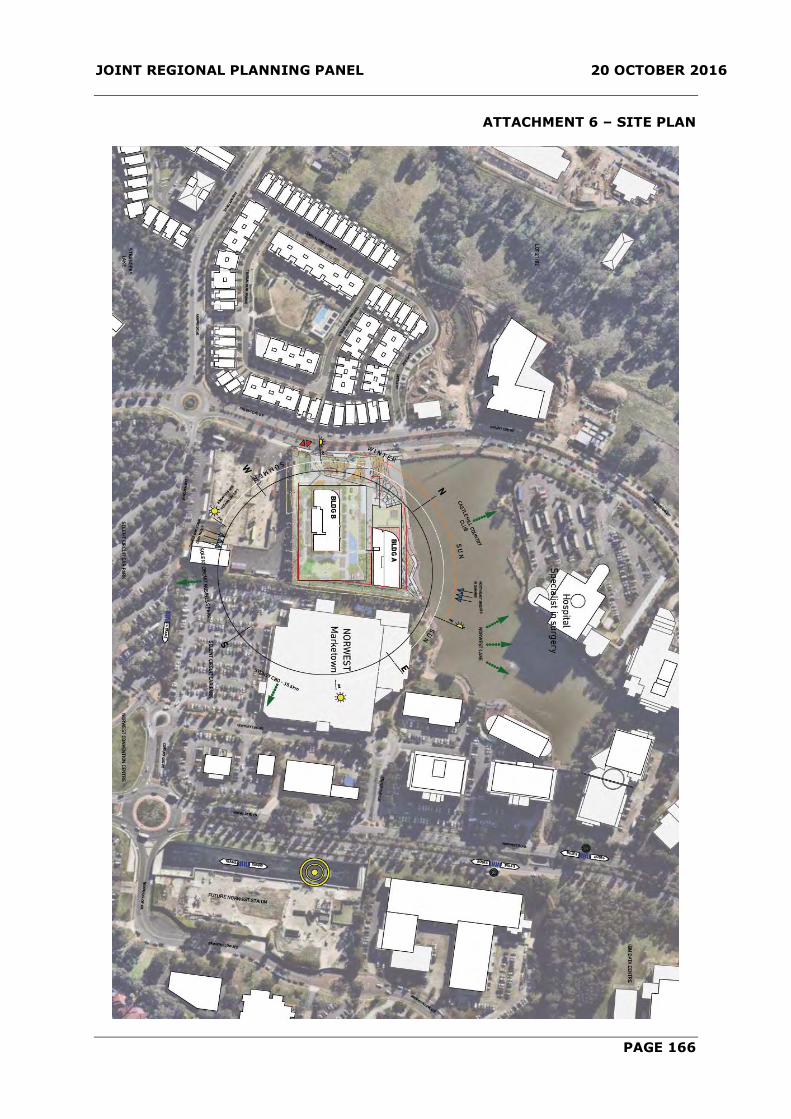
JOINT REGIONAL PLANNING PANEL 20 OCTOBER 2016
PAGE 166
ATTACHMENT 6 – SITE PLAN

JOINT REGIONAL PLANNING PANEL 20 OCTOBER 2016
PAGE 167
ATTACHMENT 7 – GROUND FLOOR PLAN

JOINT REGIONAL PLANNING PANEL 20 OCTOBER 2016
PAGE 168
ATTACHMENT 8 – NORTH ELEVATION

JOINT REGIONAL PLANNING PANEL 20 OCTOBER 2016
PAGE 169
ATTACHMENT 9 – SOUTH ELEVATION

JOINT REGIONAL PLANNING PANEL 20 OCTOBER 2016
PAGE 170
ATTACHMENT 10 – EAST ELEVATION

JOINT REGIONAL PLANNING PANEL 20 OCTOBER 2016
PAGE 171
ATTACHMENT 11 – WEST ELEVATION
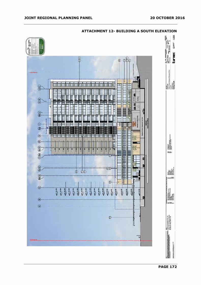
JOINT REGIONAL PLANNING PANEL 20 OCTOBER 2016
PAGE 172
ATTACHMENT 12- BUILDING A SOUTH ELEVATION

JOINT REGIONAL PLANNING PANEL 20 OCTOBER 2016
PAGE 173
ATTACHMENT 13- BUILDING B NORTH ELEVATION

JOINT REGIONAL PLANNING PANEL 20 OCTOBER 2016
PAGE 174
ATTACHMENT 14- LANDSCAPE PLAN - GROUNDFLOOR

JOINT REGIONAL PLANNING PANEL 20 OCTOBER 2016
PAGE 175
ATTACHMENT 15- LANDSCAPE PLAN – PODIUM LEVEL

JOINT REGIONAL PLANNING PANEL 20 OCTOBER 2016
PAGE 176
ATTACHMENT 16- SHADOW DIAGRAMS
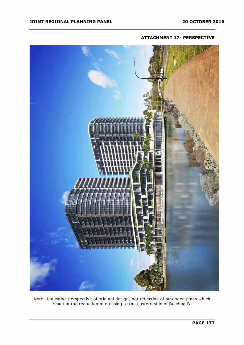
JOINT REGIONAL PLANNING PANEL 20 OCTOBER 2016
PAGE 177
ATTACHMENT 17- PERSPECTIVE
Note: Indicative perspective of original design, not reflective of amended plans which
result in the reduction of massing to the eastern side of Building B.