journal of south american earth sciences - atlantidea.org · y las facies observadas en la...
TRANSCRIPT

Journal of South American Earth Sciences 27 (2009) 74–87
Contents lists available at ScienceDirect
Journal of South American Earth Sciences
journal homepage: www.elsevier .com/locate / jsames
Stratigraphy and architecture of the Upper Triassic Ischigualasto Formation,Ischigualasto Provincial Park, San Juan, Argentina
Brian S. Currie a,*, Carina E. Colombi b,1, Neil J. Tabor c,2, Todd C. Shipman d,3, Isabel P. Montañez e,4
a Department of Geology, 114 Shideler Hall, Miami University, Oxford, OH 45056, United Statesb Museo de Ciencias Naturales/Universidad National de San Juan, San Juan 5400, Argentinac Department of Geological Sciences, Southern Methodist University, Dallas, TX 75275-0395, United Statesd Department of Geosciences, University of Arizona, Tucson, AZ 85721, United Statese Department of Geology, University of California, Davis, CA 95616, United States
a r t i c l e i n f o a b s t r a c t
Keywords:Upper TriassicRift basinAlluvial architectureFluvial-channel geometryPaleosols
0895-9811/$ - see front matter � 2008 Elsevier Ltd. Adoi:10.1016/j.jsames.2008.10.004
* Corresponding author. Tel.: +1 513 529 7578.E-mail addresses: [email protected] (B.S. Curri
[email protected] (I.P. Montañez).1 Tel.: +54 264 421 6774.2 Tel.: +1 214 768 4175.3 Tel.: +1 520 740 1537.4 Tel.: +1 530 754 7823.
The Ischigualasto Formation in northwestern Argentina contains abundant fluvial channel sandstones,overbank mudstones, and paleosols that were deposited in a northwest-trending continental-rift basinduring Late Triassic time. In the study area the formation progressively thins from �700 m in the westto �400 m in the east, over a distance of 7 km. This thinning is accompanied by a relative decrease inthe abundance of fluvial channel sandstones and an increase in mud-rich overbank deposits and paleo-sols. While preserved channel deposits in the formation are highly variable in terms of their size andstratigraphic distribution, four general channel forms can be recognized based on their overall cross sec-tional geometry and internal sedimentary structures. Of these, the dominant channel-body types areinterpreted as the deposits of sandy multi-channel fluvial systems. The internal stratigraphic architectureof the Ischigualasto Formation indicates that during deposition, the central part of the basin was the loca-tion of a long-lived, north flowing, fluvial channel belt that received relatively continuous channel andproximal overbank deposition. To the east, however, channel-related deposition was more infrequent,resulting in enhanced pedogenic modification of alluvial deposits. The overall thickness and facies trendsobserved in the Ischigualasto Formation most likely correspond to variations in fault-related accommo-dation development within the basin during the time of deposition.
� 2008 Elsevier Ltd. All rights reserved.
a r t i c l e i n f o r e s u m e n
Keywords:Upper TriassicRift basinAlluvial architectureFluvial-channel geometryPaleosols
La Formación Ischigualasto, en el NO argentino, esta formada por areniscas de canales fluviales, pelitas dedesbordamientos y paleosuelos. Estos sedimentos fueron depositados en una cuenca rift continental, ori-entada NW–SE, durante el Triásico Superior. En el área de estudio la Formación se adelgaza progresiva-mente desde �700 m en el oeste a �400 m en el este, a lo largo de una distancia de 7 km. Esteadelgazamiento esta acompañado por una disminución relativa en la abundancia de canales fluviales are-niscosos y un incremento de los los depósitos pelíticos de desbordamiento y paleosuelos.Si bien los depósitos de canales son altamente variables en tamaño y distribución estratigráfica, se hanpodido clasificar cuatro tipos de canales en función de rasgos geométricos y estructuras sedimentariasinternas generales. De estos depósitos, los tipos de canales dominantes son los sistemas fluviales arenisc-osos multicanales. La arquitectura estratigráfica de la Formación Ischigualasto indica que durante sudepositación, el centro de la cuenca fue el depocentro prolongado de depósitos de canales y de desbord-amiento de una faja de canales fluviales que fluía hacia el norte. Sin embargo, en el este de la cuenca ladepositación relacionada a canales fluviales fue menos importante, dando como resultado un incrementode las modificaciones pedogenéticas en los depósitos aluviales. Las tendencias generales de los espesores
ll rights reserved.
e), [email protected] (C.E. Colombi), [email protected] (N.J. Tabor), [email protected] (T.C. Shipman),

SantiagoBuenos Aires
30˚
40˚
50˚
60˚80˚ 40˚
Middle-UpperTriassic Rocks
I.B.
Argentina
San Juan
a
b
Rio Bermejo
30°
c
Triassic Basins of SouthernSouth America
c
Fig. 1. Location maps of the Ischigualasto Basin. (a) Din NW Argentina and the study area depicted in Figusouthern part of the Ischigualasto-Villa Unión Basin.
B.S. Currie et al. / Journal of South American Earth Sciences 27 (2009) 74–87 75
y las facies observadas en la Formación Ischigualasto parecen corresponder a variaciones en el espacio deacomodamiento de fallas ubicadas dentro de la cuenca durante su depositación.
� 2008 Elsevier Ltd. All rights reserved.
1. Introduction
The three-dimensional geometry of alluvial successions in con-tinental rift basins can provide significant information on the fac-tors influencing deposition. One of the primary results from boththeoretical and numerical models on rift basin evolution is thatspatial and temporal variations of syndepositional faulting can pro-duce lateral variations in the magnitude and rate of basin subsi-dence and strongly influence the character and distribution ofbasin depositional systems (Bridge and Leeder, 1979; Leeder andGawthorpe, 1987; Mackey and Bridge, 1995). Fault-related pro-cesses, such as along-strike changes in basin-bounding fault dis-placement, lateral tilting of hanging wall depositional surfaces,and activity on intrabasinal fault systems can control thickness oflithostratigraphic units, the geometry, interconnectedness andstacking patterns of fluvial channel deposits, as well as preserva-tion of overbank lithologies, and the distribution of paleosols (Al-len, 1974; Bridge and Leeder, 1979; Schlische, 1993). As such,documenting the architecture of alluvial successions can provideinsight into the structural and tectonic controls on rift basinevolution.
In rifts, as in other alluvial basins, overall architecture isstrongly influenced by rates and magnitude of sediment accumula-tion, which on the formation scale is roughly equal to basin subsi-dence. There are, however, two points of view on this topic.Numerical models such of those by Leeder (1978), Allen (1978)and Bridge and Leeder (1979), predict that the overall architecturalarrangement of fluvial channel sandstones varies according to theamount and rate of subsidence. These models, which assume aconstant channel avulsion frequency, predict that fluvial channelsandstones will become vertically and laterally separated by higherpercentages of fine-grained overbank deposits during periods of in-creased subsidence. In turn, when subsidence rates decrease, flu-
Rio La Peña
5 km
Section 1
68°
istribution of Triassic basins in soutre 1c. (b) Map of San Juan ProvincIschigualasto Fm. measured Section
vial channel deposits will become amalgamated both verticallyand laterally.
Heller and Paola (1996) questioned the validity of the abovearchitectural models in view the potential effects that channel-avulsion frequency may have on overall fluvial architecture. Theirargument was that the overall thickness and connectivity of chan-nel sandstones is highly dependant on the relationship betweenavulsion frequency and aggradation rate. During periods of rapidsubsidence, a higher frequency of avulsion may potentially pro-duce greater lateral continuity in fluvial channel bodies. In turn,when aggradation rate slows, a corresponding reduction in the fre-quency of stream-channel avulsion may produce fluvial channelbodies that are geometrically isolated.
The Ischigualasto Formation of northwestern Argentina providesan excellent opportunity to test current ideas on the relationshipsbetween alluvial architecture in response to variations in basinaccommodation development. The Ischigualasto Formation is a flu-vial-dominated stratigraphic unit that was deposited in a continen-tal extensional basin during Late Triassic time (Alcober, 1996).Despite pronounced lateral changes in formation thickness(�300 m over a distance of 7 km), the lack of intraformationalunconformities and lateral continuity of lithostratigraphic mem-bers indicates that deposition was relatively continuous (Milanaand Alcober, 1994). This allows overall formation architecture tobe viewed within the context of lateral variations in basin subsi-dence. By focusing on the relationships between the geometryand stratigraphic arrangement of fluvial channel sandstones andassociated floodplain deposits in both low and high accommodationzones within the basin, current ideas concerning the alluvial archi-tectural response to changes in basin subsidence can be evaluated.These relationships can also be used to discern the overall structuralcontrols on Ischigualasto Formation deposition, and serve as a basisof comparison with other fluvial-dominated rift assemblages.
Falla del A
lto
Ruta 26
Igneous/Metamorphic
Tuminico Fm.
PC-PZ
Carb.
Triassic
Chanares,Ischichuca,Talampaya, andTarjados Fms.
Los Rastros Fm.
Basalt
Ischigualasto Fm.
Los Colorados Fm.
K-TCerro Rajado andQuebrada del Médano Fms.
QAlluvial Fan,Fluvial, and Eolian Deposits
Explanation
high-angle reverse fault
Section 2
Section 3
hern South America. ‘‘I.B.” marks the location of the Ischigualasto-Villa Unión Basine, Argentina. White rectangle shows location of Figure 1c. (c) Geologic map of thes 1–3 shown in Figs. 3 and 4. Modified from Alcober (1996).

76 B.S. Currie et al. / Journal of South American Earth Sciences 27 (2009) 74–87
2. Geologic setting
During Mesozoic time, oceanic–continental plate interactionsalong the southwestern margin of Pangea produced a region ofextensional deformation cratonward of the proto-Andean mag-matic arc (Ramos and Kay, 1991; Lopez-Gamundi et al., 1994).Extension was focused along the NW-trending boundary betweenPaleozoic accreted terranes and the Precambrian Gondwanan cra-ton (Uliana et al., 1989). The Ischigualasto basin of northwestArgentina is one of a series of continental-rifts that developed inthe region as a result of this extension (Fig. 1) (Uliana and Biddle,1988). Rift-related deposition in the Ischigualasto Basin began dur-ing Early Triassic time, as northeast-directed normal displacementon the paleo-Valle Fértil fault and the antithetic paleo-Alto faultled to the development of a structural half-graben (Milana andAlcober, 1994; Lopez, 1995). The Valle Fértil fault is interpretedas the main, basin-bounding normal fault separating Proterozoic–Paleozoic crystalline and sedimentary rocks of the footwall fromthe Triassic sedimentary rocks of the hanging wall. Deposition inthe basin continued throughout Triassic time and resulted in accu-mulation of >3.5 km of nonmarine and volcanic strata (Alcober,1996).
Pleistocene shortening within the foreland of the Andes pro-duced reverse-displacement reactivation of Mesozoic normalfaults and structural inversion of Ischigualasto Basin strata (Zapataand Allmendinger, 1996). Uplift and erosion of basin strata has re-sulted in near-complete exposure of the Ischigualasto Triassicstratigraphic interval in the hanging wall of the Valle Fértil andAlto faults (Fig. 1). In the study area the Ischigualasto Fm. dipsup to 25� NW along the contact with the Alto Fault (Section 3),but has a regional dip of 4–10� NE in the western parts of the studyarea (Sections 1 and 2) (Fig. 1).
3. Ischigualasto Formation stratigraphy and age
As part of our investigation we measured three detailed strati-graphic sections through the Ischigualasto Formation in the east-ern part of the Ischigualasto Provincial Park (Fig. 1). An UpperTriassic age of the Ischigualasto Formation is based on vertebratefossils and radiometric ages of altered ash beds from the unitand basalt flows immediately underlying the formation (Fig. 2).Abundant vertebrate fossils in the lower 2/3 of the formation(including the rhynchosaur Scaphonyx, the cynodont Exaeretodon,and primitive theropod dinosaurs Eoraptor and Herrerasaurus) indi-cate a Carnian age of deposition (Rogers et al., 1993; Martinez,1994; Alcober, 1996). Altered ash beds in the Ischigualasto Forma-tion have provided additional chronostratigraphic control. Sani-
Tri
assi
c
220
230
Formation/Member
Isch
igua
last
o F
m.
Los Rastros Fm.
Los Colorados Fm.
La Peña Mbr.
Cancha de Bochas Mbr.
Valle de la Luna Mbr.
Quebrada de la Sal Mbr.
Norian
Carnian
Ladinian
Mid
dle
Upp
er
Series/StagePeriod
Ma
*
*
* 229±5
227.8 ±0.3
217.0 ±1.7
RadiometricAge (Ma)
Fig. 2. Time-stratigraphic chart for Middle–Upper Triassic rocks of the Ischigualastobasin including newly defined lithostratigraphic members of the Ischigualasto Fm.and relative position of radiometrically dated horizons. Time scale adapted fromGradstein et al. (1995) and Alcober (1996).
dine crystals from a bentonite sampled �80 m above the base ofthe formation near Section 2 yield an 40Ar/39Ar date of227.8 ± 0.3 Ma (Rogers et al., 1993) while plagioclase crystals froma bentonite �70 m from the top of the formation in Section 1(Fig. 3) provide a date of 217.0 ± 1.7 Ma (Shipman, 2004). In addi-tion, to the east of the study area, in the footwall of the Alto fault isa thick accumulation of basaltic dikes and flows (Fig. 1). A K/Ardate of 229 ± 5 Ma on these basalts (Odin et al., 1982) suggeststhey maybe correlative with the basalt flows preserved in the low-er part of the Ischigualasto Formation in Section 3. Collectively,these ages support a Carnian age of deposition based on the Trias-sic time-scale of Gradstein et al. (1995) (Fig. 2).
The Ischigualasto Formation consists of �300–700 m of mud-stone, sandstone, conglomerate, and basalt ( Figs. 3 and 4). Thesedimentary rocks of the formation are primarily channel andoverbank deposits of fluvial systems sourced in highlands south-west of Valle Fértil paleofault and south-southeast of El Altopaleofault, whereas the basalts were formed by flows originatingfrom volcanic centers located at the east and northwest marginsof the basin (Alcober, 1996). From west to east across the studyarea, the Ischigualasto Formation exhibits dramatic changes inthickness and lithologic variability. In the west (Section 1), the for-mation is 691 m thick and is dominated by fluvial channel sand-stones, particularly in the upper half of the formation (Fig. 3). Tothe east, the formation thins from 413 m in Section 2 to 397 min Section 3, and contains a larger percentage of mudstone(Fig. 4). Internally, the Ischigualasto Formation can be subdividedinto four lithostratigraphic members, including the basal La PeñaMember, the Cancha de Bochas Member, the Valle de la LunaMember, and the Quebrada de la Sal Member. Formal designationand a detailed description of these members are presented inAppendix A.
4. Alluvial architecture
Lithofacies in the Ischigualasto Formation indicate deposition influvial channel and overbank environments (Alcober, 1996). Lithof-acies characteristics, which were classified using the scheme ofMiall (1981), are listed in Table 1. Lithofacies assemblages in theIschigualasto Formation can be subdivided into nine differentarchitectural elements based on associations, geometry, paleocur-rent orientation, and bounding-surface hierarchy (Table 2). Eachelement is interpreted to be the depositional product of a particu-lar process or suite of processes occurring within the Ischigualastoalluvial system (Miall, 1985). Of these elements, four are inter-preted to have formed in fluvial channel and five in overbank envi-ronments. Channel elements include the deposits of gravelbedforms, sandy bedforms, and downstream and lateral accretionelements. Overbank elements include levee deposits, crevassesplay deposits, floodplain fines, abandoned channel deposits, andpaleosols.
4.1. Channel elements
4.1.1. Gravelly bed elementsGravelly bed elements consist of horizontally-stratified, clast-
supported, pebble–cobble conglomerate beds (lithofacies Gh) thatare bounded by fourth-order surfaces (e.g. Miall, 1991), the basesof which may exhibit erosional scours with up to 2.0 m of relief.In some cases, however, the base of these elements correspondsto the fifth-order bases of channel bodies. Gravelly bed elementsare found primarily in the lower parts of channel-form bodiesand are commonly overlain by sandy bed, downstream accretion,and lateral accretion elements (see below). Gravelly bed elementsare interpreted as the deposits of low-relief gravel bedforms or

Fig. 3. Log of Ischigualasto Formation measured Section 1. See Fig. 1 for location.
B.S. Currie et al. / Journal of South American Earth Sciences 27 (2009) 74–87 77
bedload sheets or, where occurring along basal scoured surfaces,channel-lag deposits (cf. Hein and Walker, 1977).
4.1.2. Sandy bed elementsSandy bed elements consist of trough- and planar cross strat-
ified sandstone, ripple cross laminated sandstones, and plane-parallel laminated sandstones (lithofacies St, Sp, Sr, Sh) boundedby second- and third-order surfaces. In some cases, however,the base of these elements correspond to the fourth- and fifth-order scoured bases of minor channel fills and channel bodies,respectively. Sandy bed elements are interpreted as the depositsof bedforms (lithofacies St and Sp) that filled Ischigualasto fluvialchannels as a result of vertical bed aggradation or accumulatedalong channel margins and the tops of macroforms during fallingstages of flow (lithofacies Sr and Sh) (Cant and Walker, 1978;Miall, 1996).
4.1.3. Downstream accretion elementsDownstream accretion elements are bounded by fourth-order
surfaces, except where lower surfaces correspond to the fifth-orderbases of channel bodies. Internally, downstream accretion ele-ments contain second- and third-order surfaces that bound setsand cosets of trough-stratified, plane-parallel laminated, and ripple
cross laminated sandstone. These bounding surfaces dip at low an-gles (<10�) in the direction of paleoflow. These elements are inter-preted to have formed as a result of downstream accretion of barcomplexes in sand-dominated fluvial channels (Allen et al., 1983;Miall, 1985).
4.1.4. Lateral accretion elementsLateral accretion elements are bounded by fourth-order sur-
faces, except where lower surfaces correspond to the fifth-orderbases of channel bodies. In some cases, lateral accretion elementtops are gradational with vertically accreted floodplain deposits(element FF, see below). Internally, lateral accretion elements con-tain second- and third-order surfaces that dip <20� perpendicular/oblique to the direction of paleoflow and bound sets and cosets oftrough cross stratified and ripple cross laminated sandstone, aswell as beds of plane-parallel laminated sandstone. In some casesthese inclined strata contain intercalated ripple cross laminatedsandstones and mudstones. Lateral accretion elements are inter-preted as the deposits of point bars in single-channel fluvial sys-tems (Allen, 1963; Puigdefábregas, 1973), or mid-channel barsand bar complexes in sand dominated, multi-channel fluvial sys-tems (Miall, 1993). Interbedded cross laminated sandstones andmudstones contained in these lateral-accretion strata indicate
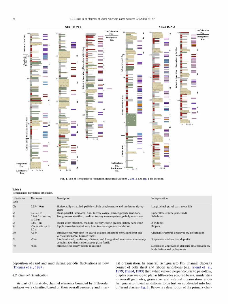
Fig. 4. Log of Ischigualasto Formation measured Sections 2 and 3. See Fig. 1 for location.
Table 1Ischigualasto Formation lithofacies.
Lithofaciescode
Thickness Description Interpretation
Gh 0.25–1.0 m Horizontally-stratified, pebble–cobble conglomerate and mudstone rip-upclasts
Longitudinal gravel bars, scour fills
Sh 0.2–2.0 m Plane-parallel laminated, fine- to very coarse-grained/pebbly sandstone Upper flow-regime plane bedsSt 0.2–4.0 m sets up
to 7.0 mTrough-cross stratified, medium to very coarse-grained/pebbly sandstone 3-D dunes
Sp 0.15–1 m Planar-cross stratified, medium- to very coarse-grained/pebbly sandstone 2-D dunesSr <5 cm sets up to
2.5 mRipple cross-laminated, very fine- to coarse-grained sandstone Ripples
Sm <.5 m Structureless, very fine- to coarse-grained sandstone containing root andvertical/horizontal burrow traces
Original structures destroyed by bioturbation
Fl <2 m Interlaminated, mudstone, siltstone, and fine-grained sandstone; commonlycontains abundant carbonaceous plant fossils
Suspension and traction deposits
Fm <5 m Structureless sandy/pebbly mudstone Suspension and traction deposits amalgamated bybioturbation and pedogenesis
78 B.S. Currie et al. / Journal of South American Earth Sciences 27 (2009) 74–87
deposition of sand and mud during periodic fluctuations in flow(Thomas et al., 1987).
4.2. Channel classification
As part of this study, channel elements bounded by fifth-ordersurfaces were classified based on their overall geometry and inter-
nal organization. In general, Ischigualasto Fm. channel depositsconsist of both sheet and ribbon sandstones (e.g. Friend et al.,1979; Friend, 1983) that, when viewed perpendicular to paleoflow,display concave-up to planar fifth-order scoured bases. Similaritiesin overall geometry, grain size, and internal organization, allowIschigualasto fluvial sandstones to be further subdivided into fourdifferent classes (Fig. 5). Below is a description of the primary char-
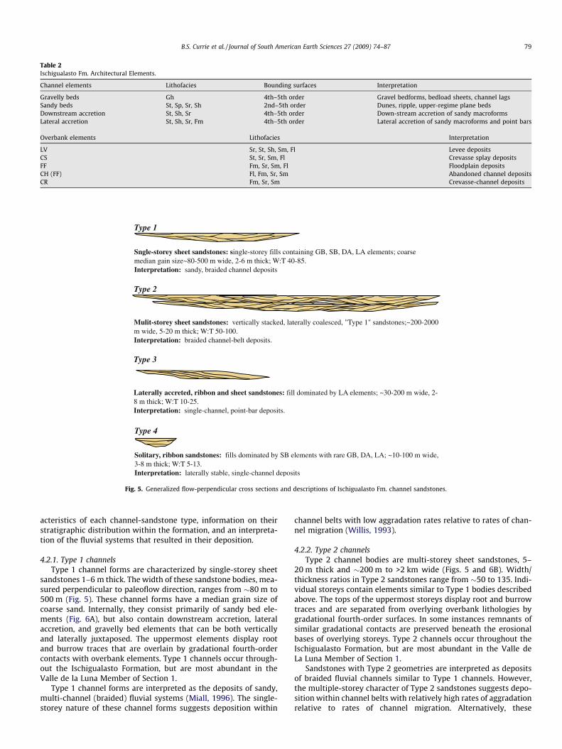
Table 2Ischigualasto Fm. Architectural Elements.
Channel elements Lithofacies Bounding surfaces Interpretation
Gravelly beds Gh 4th–5th order Gravel bedforms, bedload sheets, channel lagsSandy beds St, Sp, Sr, Sh 2nd–5th order Dunes, ripple, upper-regime plane bedsDownstream accretion St, Sh, Sr 4th–5th order Down-stream accretion of sandy macroformsLateral accretion St, Sh, Sr, Fm 4th–5th order Lateral accretion of sandy macroforms and point bars
Overbank elements Lithofacies Interpretation
LV Sr, St, Sh, Sm, Fl Levee depositsCS St, Sr, Sm, Fl Crevasse splay depositsFF Fm, Sr, Sm, Fl Floodplain depositsCH (FF) Fl, Fm, Sr, Sm Abandoned channel depositsCR Fm, Sr, Sm Crevasse-channel deposits
Type 1
Sngle-storey sheet sandstones: single-storey fills containing GB, SB, DA, LA elements; coarse median gain size~80-500 m wide, 2-6 m thick; W:T 40-85. Interpretation: sandy, braided channel deposits
Type 2
Mulit-storey sheet sandstones: vertically stacked, laterally coalesced, "Type 1" sandstones;~200-2000 m wide, 5-20 m thick; W:T 50-100.Interpretation: braided channel-belt deposits.
Type 3
Laterally accreted, ribbon and sheet sandstones: fill dominated by LA elements; ~30-200 m wide, 2-8 m thick; W:T 10-25.Interpretation: single-channel, point-bar deposits.
Type 4
Solitary, ribbon sandstones: fills dominated by SB elements with rare GB, DA, LA; ~10-100 m wide, 3-8 m thick; W:T 5-13.Interpretation: laterally stable, single-channel deposits
Fig. 5. Generalized flow-perpendicular cross sections and descriptions of Ischigualasto Fm. channel sandstones.
B.S. Currie et al. / Journal of South American Earth Sciences 27 (2009) 74–87 79
acteristics of each channel-sandstone type, information on theirstratigraphic distribution within the formation, and an interpreta-tion of the fluvial systems that resulted in their deposition.
4.2.1. Type 1 channelsType 1 channel forms are characterized by single-storey sheet
sandstones 1–6 m thick. The width of these sandstone bodies, mea-sured perpendicular to paleoflow direction, ranges from �80 m to500 m (Fig. 5). These channel forms have a median grain size ofcoarse sand. Internally, they consist primarily of sandy bed ele-ments (Fig. 6A), but also contain downstream accretion, lateralaccretion, and gravelly bed elements that can be both verticallyand laterally juxtaposed. The uppermost elements display rootand burrow traces that are overlain by gradational fourth-ordercontacts with overbank elements. Type 1 channels occur through-out the Ischigualasto Formation, but are most abundant in theValle de la Luna Member of Section 1.
Type 1 channel forms are interpreted as the deposits of sandy,multi-channel (braided) fluvial systems (Miall, 1996). The single-storey nature of these channel forms suggests deposition within
channel belts with low aggradation rates relative to rates of chan-nel migration (Willis, 1993).
4.2.2. Type 2 channelsType 2 channel bodies are multi-storey sheet sandstones, 5–
20 m thick and �200 m to >2 km wide (Figs. 5 and 6B). Width/thickness ratios in Type 2 sandstones range from �50 to 135. Indi-vidual storeys contain elements similar to Type 1 bodies describedabove. The tops of the uppermost storeys display root and burrowtraces and are separated from overlying overbank lithologies bygradational fourth-order surfaces. In some instances remnants ofsimilar gradational contacts are preserved beneath the erosionalbases of overlying storeys. Type 2 channels occur throughout theIschigualasto Formation, but are most abundant in the Valle deLa Luna Member of Section 1.
Sandstones with Type 2 geometries are interpreted as depositsof braided fluvial channels similar to Type 1 channels. However,the multiple-storey character of Type 2 sandstones suggests depo-sition within channel belts with relatively high rates of aggradationrelative to rates of channel migration. Alternatively, these
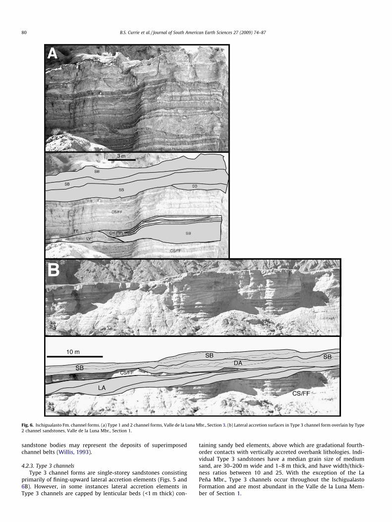
Fig. 6. Ischigualasto Fm. channel forms. (a) Type 1 and 2 channel forms, Valle de la Luna Mbr., Section 3. (b) Lateral accretion surfaces in Type 3 channel form overlain by Type2 channel sandstones, Valle de la Luna Mbr., Section 1.
80 B.S. Currie et al. / Journal of South American Earth Sciences 27 (2009) 74–87
sandstone bodies may represent the deposits of superimposedchannel belts (Willis, 1993).
4.2.3. Type 3 channelsType 3 channel forms are single-storey sandstones consisting
primarily of fining-upward lateral accretion elements (Figs. 5 and6B). However, in some instances lateral accretion elements inType 3 channels are capped by lenticular beds (<1 m thick) con-
taining sandy bed elements, above which are gradational fourth-order contacts with vertically accreted overbank lithologies. Indi-vidual Type 3 sandstones have a median grain size of mediumsand, are 30–200 m wide and 1–8 m thick, and have width/thick-ness ratios between 10 and 25. With the exception of the LaPeña Mbr., Type 3 channels occur throughout the IschigualastoFormation and are most abundant in the Valle de la Luna Mem-ber of Section 1.
B.S. Currie et al. / Journal of South American Earth Sciences 27 (2009) 74–87 81
Type 3 channel sands are interpreted as the deposits of point-bars in single channel fluvial systems (Allen, 1963; Puigdefábregas,1973). Associated lenses of sandy bed elements are interpreted asscroll bar or chute-channel fills deposited on the upper parts ofpoint bars (Miall, 1996).
4.2.4. Type 4 channelsType 4 channel forms consist of single-story, ribbon sandstones,
10–100 m wide and 3–8 m thick (Fig. 5). Internally, Type 4 chan-nels are filled primarily by sandy bed elements (Fig. 6A), althoughgravelly bed, downstream accretion, and rare lateral accretion ele-ments have been observed. Aside from their dominantly sandy bedfill elements, Type 4 channels differ from Type 3 channels due totheir lower width/thickness ratios (5–13) and overall coarser med-ian grain size (coarse sand). Type 4 channels occur throughout theIschigualasto Formation, with the exception of the La Peña Mem-ber. They are most abundant in the Valle de la Luna Member of Sec-tion 3.
Type 4 sandstones are interpreted as the deposits of low sinuos-ity, laterally-stable, single-channel fluvial systems. Single-storeychannel forms similar to Ischigualasto Fm. Type 4 channels havebeen described by Allen et al. (1983) and Eberth and Miall (1991).
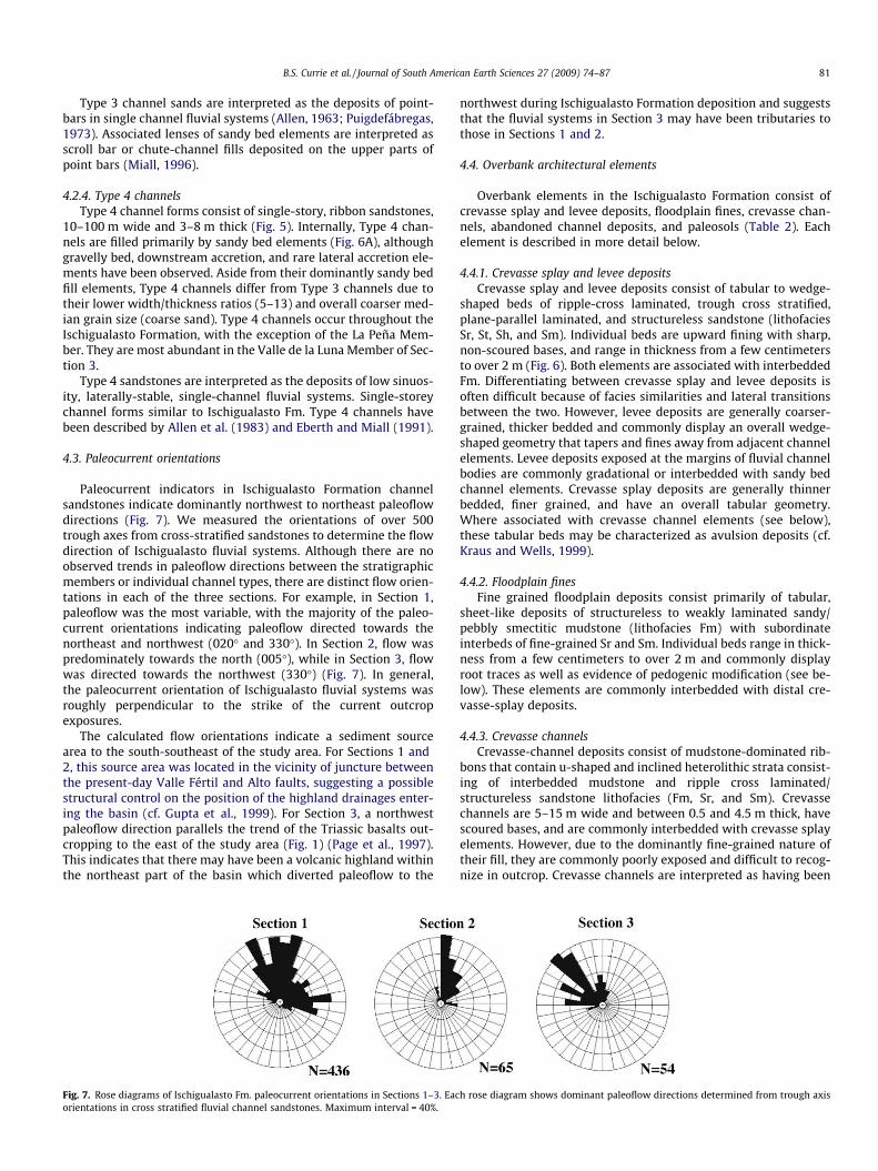
4.3. Paleocurrent orientations
Paleocurrent indicators in Ischigualasto Formation channelsandstones indicate dominantly northwest to northeast paleoflowdirections (Fig. 7). We measured the orientations of over 500trough axes from cross-stratified sandstones to determine the flowdirection of Ischigualasto fluvial systems. Although there are noobserved trends in paleoflow directions between the stratigraphicmembers or individual channel types, there are distinct flow orien-tations in each of the three sections. For example, in Section 1,paleoflow was the most variable, with the majority of the paleo-current orientations indicating paleoflow directed towards thenortheast and northwest (020� and 330�). In Section 2, flow waspredominately towards the north (005�), while in Section 3, flowwas directed towards the northwest (330�) (Fig. 7). In general,the paleocurrent orientation of Ischigualasto fluvial systems wasroughly perpendicular to the strike of the current outcropexposures.
The calculated flow orientations indicate a sediment sourcearea to the south-southeast of the study area. For Sections 1 and2, this source area was located in the vicinity of juncture betweenthe present-day Valle Fértil and Alto faults, suggesting a possiblestructural control on the position of the highland drainages enter-ing the basin (cf. Gupta et al., 1999). For Section 3, a northwestpaleoflow direction parallels the trend of the Triassic basalts out-cropping to the east of the study area (Fig. 1) (Page et al., 1997).This indicates that there may have been a volcanic highland withinthe northeast part of the basin which diverted paleoflow to the
Fig. 7. Rose diagrams of Ischigualasto Fm. paleocurrent orientations in Sections 1–3. Eacorientations in cross stratified fluvial channel sandstones. Maximum interval = 40%.
northwest during Ischigualasto Formation deposition and suggeststhat the fluvial systems in Section 3 may have been tributaries tothose in Sections 1 and 2.
4.4. Overbank architectural elements
Overbank elements in the Ischigualasto Formation consist ofcrevasse splay and levee deposits, floodplain fines, crevasse chan-nels, abandoned channel deposits, and paleosols (Table 2). Eachelement is described in more detail below.
4.4.1. Crevasse splay and levee depositsCrevasse splay and levee deposits consist of tabular to wedge-
shaped beds of ripple-cross laminated, trough cross stratified,plane-parallel laminated, and structureless sandstone (lithofaciesSr, St, Sh, and Sm). Individual beds are upward fining with sharp,non-scoured bases, and range in thickness from a few centimetersto over 2 m (Fig. 6). Both elements are associated with interbeddedFm. Differentiating between crevasse splay and levee deposits isoften difficult because of facies similarities and lateral transitionsbetween the two. However, levee deposits are generally coarser-grained, thicker bedded and commonly display an overall wedge-shaped geometry that tapers and fines away from adjacent channelelements. Levee deposits exposed at the margins of fluvial channelbodies are commonly gradational or interbedded with sandy bedchannel elements. Crevasse splay deposits are generally thinnerbedded, finer grained, and have an overall tabular geometry.Where associated with crevasse channel elements (see below),these tabular beds may be characterized as avulsion deposits (cf.Kraus and Wells, 1999).
4.4.2. Floodplain finesFine grained floodplain deposits consist primarily of tabular,
sheet-like deposits of structureless to weakly laminated sandy/pebbly smectitic mudstone (lithofacies Fm) with subordinateinterbeds of fine-grained Sr and Sm. Individual beds range in thick-ness from a few centimeters to over 2 m and commonly displayroot traces as well as evidence of pedogenic modification (see be-low). These elements are commonly interbedded with distal cre-vasse-splay deposits.
4.4.3. Crevasse channelsCrevasse-channel deposits consist of mudstone-dominated rib-
bons that contain u-shaped and inclined heterolithic strata consist-ing of interbedded mudstone and ripple cross laminated/structureless sandstone lithofacies (Fm, Sr, and Sm). Crevassechannels are 5–15 m wide and between 0.5 and 4.5 m thick, havescoured bases, and are commonly interbedded with crevasse splayelements. However, due to the dominantly fine-grained nature oftheir fill, they are commonly poorly exposed and difficult to recog-nize in outcrop. Crevasse channels are interpreted as having been
h rose diagram shows dominant paleoflow directions determined from trough axis

82 B.S. Currie et al. / Journal of South American Earth Sciences 27 (2009) 74–87
low- to high-sinuosity and mud-dominated. Their geometries andconstituent lithofacies are similar to crevasse channels describedby Smith et al. (1989), Eberth and Miall (1991), and Kraus andWells (1999).
4.4.4. Abandoned channel depositsAbandoned channel elements consist of lenses of interlaminat-
ed mudstone, siltstone, and fine-grained sandstone (lithofacies Fl,Fm, Sr, and Sm) that immediately overlie fluvial channel elements(in a gradational fourth-order contact). These elements commonlycontain abundant, finely-disseminated carbonaceous material andplant fossils.
Table 3Relative abundances of Ischigualasto Fm. architectural elements.
Section 1 Section 2 Section 3
Thickness 691 413 397Number of channel forms 52 29 17% Channel deposits 31% 23% 21%% Type 1 9% (n = 24) 7% (n = 16) 8% (n = 9)% Type 2 14% (n = 14) 10% (n = 6) 5% (n = 2)% Type 3 5% (n = 9) 2% (n = 2) 1% (n = 1)% Type 4 3% (n = 5) 4% (n = 5) 7% (n = 5)% CS + CR + LV 23% 23% 24%% FF + CH(FF) 46% 54% 55%% Paleosols 23% 30% 38%
Fig. 8. Generalized W-E basin cross section between Sections 1 and 3 showing thicknessscale syndepostional fault zone and positions and relative geometries of and fluvial cha
4.4.5. PaleosolsThe Ischigualasto formation contains abundant paleosols that
display a wide range of pedogenic characteristics. Individual paleo-sols range in thickness from �10 cm to >3 m and can contain roottraces, carbonate nodules and rhizocretions, slickensided peds,gley motteling, and well-developed Bt horizons. Based on mor-phology and composition, Tabor et al. (2006) identified 6 primarypedotypes in the study area including protosols, gleyed vertisols,calcic vertisols, argillisols, calcisols, calcic argillisols (cf. Macket al., 1993). Lateral transitions of pedotypes along individualpaleosol horizons indicates there is a trend towards more morpho-logically-mature paleosol profiles away from coeval fluvial chan-nels (Tabor et al., 2006). For example, across individualpedogenic horizons, lateral transitions are commonly observedfrom multiple stacked protosols to gleyed/calcic vertisols and argil-lisols/calcisols/calcic argillisols with increasing distance from thechannel margins. Based on these considerations, it is probable thatall pedotypes observed in the Ischigualasto formation coexisted onthe same paleolandscape. However, paleosols in the lower part ofthe Ischigualasto Formation are dominated by calcic morphologies(i.e. calcic vertisols, calcisols, calcic argillisols) such that they arethe lithostratigraphic basis for definition of the Cancha de BochasMember (Appendix A).
4.5. Distribution of architectural elements
The distribution of Ischigualasto Formation architectural ele-ments in the study area is closely linked to the lateral variations
changes in Ischigualasto Fm. lithostratigraphic members, location of possible small-nnel sandstones. See Fig. 1 for location.

B.S. Currie et al. / Journal of South American Earth Sciences 27 (2009) 74–87 83
in formation thickness observed across the study area. For exam-ple, the overall and normalized channel abundance decreases fromwest to east; 31% of the total vertical thickness of Section 1 (697 m)is made up of channel deposits while only 21% of Section 3 (397 m)contains channel forms (Table 3). While the overall percentage ofType 1 channels comprising each stratigraphic section is relativelyconstant across the study area (7–9%), the decrease in channelabundance to the east is due primarily to the number and thick-ness of Type 2 channel forms in each section. Type 2 channelsmake up 14% of the vertical thickness of in Section 1, while only5% of Section 3 consists of similar channel forms. Similarly, Type3 channel forms also decrease between Sections 1 and 3 (5–1%,respectively). The overall decrease of and Type 2 and Type 3 chan-nel bodies is accompanied by a slight increase in Type 4 channeldeposits; 3% of Section 1 is comprised of Type 4 channels while7% of Section 3 is made up of similar forms.
In terms of other overbank elements, the percentage of leveeand crevasse deposits in each section is relatively constant (23–24%), while the abundance of overbank fines increases from 46%in Section 1 to 55% in Section 3. In addition, there is an inverse rela-tionship between the percentage of preserved fluvial channeldeposits and paleosols in each section. Paleosols comprise 23%,30%, and 38% of the vertical thickness of Sections 1–3, respectively.
The relationships between Ischigualasto Formation architec-tural arrangement and stratigraphic thickness may be closely asso-ciated with differential subsidence caused by fault activity in thebasin at the time of deposition. Evidence for syndepositional fault-ing is manifested in the drastic thickness change between Sections1 and 2 where there is a >275 m change in formation thickness(Figs. 3, 4 and 8). This change in thickness may be related to analong-strike increase in displacement on the Valle Fértil paleofaultwhich generated more fault related accommodation to the north-west during deposition (Milana and Alcober, 1994) (e.g. Walsh
Fig. 9. Block diagram of the Ischigualasto basin during deposition of the Valle de la Lupossible small-scale syndepositional fault zones, and relative geometries of fluvial chan
and Watterson, 1988; Schlische, 1993). Another explanation forthe observed thickening in the Ischigualasto Formation may be re-lated to activity on small-scale (<10 m displacement) north-north-east trending, west-dipping normal faults that have been observedin outcrop in this area. Although there is no observable growthstrata in the inferred paleofault zone, displacement on down-to-the-west basement faults during Ischigualasto deposition mayhave resulted in draping of the overlying strata prior to the faultspropagating up section. Alternatively, faulting may have beenbroadly distributed in the observed zone of thickening, such thatthere is no apparent change in overall thickness across any onefault exposed at the surface. Although we have not determinedwhich of these possible faulting scenarios occurred (either aloneor in conjunction), a proportional westward increase in the thick-ness of all four lithostratigraphic members between Sections 1and 2 (Fig. 8) suggests that faulting was continuous throughoutIschigualasto Formation deposition.
As a result of the overall increase in subsidence across the basin,major fluvial channel belts were concentrated in the west of thestudy area, as is evidenced by the relative abundance of Type 2channel bodies in Section 1. The increased frequency of fluvialchannel and proximal overbank deposits in the western parts ofthe study area was balanced by an overall increase in the deposi-tion of distal fine-grained overbank deposits to the east. At thesame time, there was also an overall increase in the percentageof paleosols formed in the eastern part of the study areas whereoverall sediment accumulation rates were lower.
5. Stratigraphic evolution
The combined sedimentologic and stratigraphic data presentedabove allows for an interpretation of the structural configurationand geomorphology of the basin during Ischigualasto Formation
na Member showing thickness changes of lithostratigraphic members, location ofnel sandstones. View is towards the south.

84 B.S. Currie et al. / Journal of South American Earth Sciences 27 (2009) 74–87
deposition. During Carnian time, the basin was dominated by northflowing fluvial systems draining highlands in the footwall of theValle Fértil normal fault (Fig. 9). The dominant paleoflow directionswere parallel to slightly oblique to the basin axis based on theinterpreted NW trend of the basin-bounding Valle Fértil paleofault(Milana and Alcober, 1994). In addition, paleocurrent orientationsin channel deposits in the east part of the basin parallel the trendof Triassic volcanic rocks northeast of the study area, suggestingthe presence of a volcanic highland in the footwall of the Altopaleofault that directed fluvial systems to the northwest as itwas progressively onlapped by alluvial deposits of the Cancha deBochas, Valle de La Luna, and Quebrada de la Sal members. The ab-sence of coarse-grained lithofacies near Section 3 suggests thatthere was little to no surface expression of the Alto fault duringIschigualasto Formation deposition (Fig. 9).
During Ischigualasto Formation deposition, major fluvial sys-tems in the basin were concentrated in the western parts of thestudy area, presumably by the effects of syndepositional faulting.This faulting may have been associated with an along-strike in-crease in displacement on the basin-bounding Valle Fértil faultand/or displacement on small intrabasin normal faults. In eithercase this faulting generated greater accommodation in the westernparts of the basin and resulted in an east to west increase in forma-tion thickness from �400 m to �700 m. As faulting concentratedthe majority of the large through-flowing fluvial channels in thewestern parts of the study areas, less frequent and/or volumetricfluvial channel and overbank deposition to the east resulted inthe development of a greater abundance of paleosol horizons inthe areas of decreased subsidence.
6. Discussion
The observed relationship between subsidence variations andchannel and paleosol abundance supports current models on allu-vial architectural development. First, the observed distribution ofIschigualasto Fm. channel deposits indicate that lateral increasesin basin subsidence can result in the concentration and enhancedpreservation of fluvial channel deposits in the areas of increasedaccommodation. Given that the overall paleocurrent orientationof Ischigualasto fluvial systems was roughly perpendicular to theobserved along-strike increase in formation thickness, the distribu-tion of channel deposits is similar to architectural models that pre-dict preferential channel preservation and connectedness due toflow-perpendicular floodplain tilting or valley-parallel intrabasinfaulting (Bridge and Leeder, 1979; Mackey and Bridge, 1995). Inaddition, our observations show that the overall percentage ofpaleosols preserved in the formation is inversely proportional tothe abundance of fluvial channel deposits. The greater abundanceof paleosols in the low-accommodation eastern part of the studyarea is in accord with architectural models that predict paleosolswill be more numerous and vertically concentrated in responseto reduced rates of subsidence (Wright and Marriott, 1993; Currie,1997; Kraus 2002).
In terms of ideas regarding the interplay of avulsion frequencyand overall alluvial architecture, the inverse relationship betweenthe concentration of vertically and laterally amalgamated Type 2channel deposits and paleosol abundance in areas that experiencedgreater amounts of subsidence points to an increase in avulsionfrequency accompanying areas experiencing increased rates ofsediment accumulation (Currie, 1997; Kraus, 2002).
Collectively, our comparison between high and low accommoda-tion areas of the basin indicates that in areas of higher subsidence,fluvial channel deposits are more numerous, make up a higher per-centage of the stratigraphic section, and display more lateral conti-nuity than in low-accommodation areas of the basin. At the same
time, paleosols comprise a lower overall percentage of the strati-graphic section in areas of increased subsidence. These same rela-tionships have been recognized in other fluvial-dominated riftassemblages. For example, Mack and Madoff (2005) reported thatthe abundance of multi-storey fluvial channels (similar to Ischigual-asto Type 2 channel forms) increased in areas of increased fault gen-erated accommodation within Pliocene–Pleistocene deposits of theRio Grande Rift in the southwest United States. Mack and Madoff(2005) also documented an increase in the overall abundance ofoverbank deposits and preserved paleosols in areas away from thezones of syndepositional faulting, further corroborating our obser-vations from the Ischigualasto Formation.
Our findings from the Ischigualasto basin also have importantimplications for the distribution of amalgamated fluvial channelforms in other rift assemblages. For example, we predict that largecomposite channel form bodies likely to contain economically via-ble hydrocarbon accumulations will be concentrated in areas thathave experienced more fault-related accommodation. This predic-tion is applicable to rift assemblages dominated by axially-trend-ing fluvial systems, as well as those that experienced intrabasinfaulting oriented transverse or oblique to basin-bounding faulttrends.
Our observations that amalgamated channel complexes areconcentrated in regions experiencing greater fault-related accom-modation is most likely to be applicable for both the early and latestages of ‘‘syn-rift” deposition in continental rift basins, as thosestages are commonly characterized by widespread fluvial deposi-tion (e.g. Lambiase and Morley, 1999; Gawthorpe and Leeder,2000). Examples of continental rifts containing syn-rift fluvialdeposition include other Mesozoic rift basins in Argentina (e.g.the Cuyo, Colorado, and San Jorge basins; Uliana et al., 1989; Fitz-gerald et al., 1990; Macdonald et al., 2003), the Triassic–Jurassicrifts of the North Atlantic margin and North Sea (Tankard and Wel-sink, 1987; Ziegler, 1989; Schlische, 1993), and Early Cretaceousrift basins in eastern Asia (Lirong, 1997; Graham et al., 2001), aswell as numerous others basins developed in extensional tectonicregimes throughout geologic time.
7. Conclusions
In the Ischigualasto Provincial Park in northwest Argentina, theUpper Triassic Ischigualasto Formation consists of �400–700 m offluvial channel sandstones, overbank mudstones, paleosols, andbasalts. Internally, the Ischigualasto Formation consists of fourlithostratigraphic members which in ascending order include theLa Peña Member, the Cancha de Bochas Member, the Valle de laLuna Member, and the Quebrada de la Sal Member. Lithofaciesassemblages in the Ischigualasto Formation can be subdivided intonine different architectural elements formed in both fluvial chan-nel and overbank environments. Channel elements include thedeposits of gravel bedforms, sandy bedforms, and downstreamand lateral accretion elements. Overbank elements include leveedeposits, crevasse splay deposits, flood plain fines, abandonedchannel deposits, and paleosols. Channel deposits can be subdi-vided into four different classes based on cross-sectional geometry,grain size, and internal organization. Individual channel-formtypes are interpreted to be the deposits sandy, multi- to single-channel fluvial systems which experienced varying degrees of ver-tical and lateral amalgamation during deposition.
The internal organization of the Ischigualasto Formation is con-trolled primarily by stratigraphic variations in the location, size,and geometry of Ischigualasto fluvial channel deposits, as thesevariables relate directly to the distribution and lithologic/diage-netic characteristics of coeval overbank deposits. As a result of faultrelated subsidence, major fluvial channel belts were concentrated

B.S. Currie et al. / Journal of South American Earth Sciences 27 (2009) 74–87 85
in the west of the study area. The increased frequency of fluvialchannel and proximal overbank deposits in the west was balancedby an increased abundance of distal fine-grained overbank depositsand paleosol horizons preserved in the Ischigualasto Formation tothe east. The overall architectural arrangement is in accord withalluvial-architecture models that predict preferential channel pres-ervation and connectedness in areas that experience flow-perpen-dicular variations in basin subsidence. Likewise, our observationsare similar to other models that predict more numerous and verti-cally concentrated paleosols in areas of a basin that experience re-duced rates of accommodation development.
Acknowledgments
We are indebted to Oscar Alcober and Ricardo Martinez fromMuseo de Ciencias Naturales, San Juan, Argentina, for their assis-tance and expertise in the field area. We also thank Kelley Kelsofor assistance in the field. Reviews by Brian Willis and Angela Hess-ler greatly improved the original manuscript. This project was par-tially funded by Grants-in-Aid to N. Tabor and T. Shipman from theGeological Society of America, American Association of PetroleumGeologists, Society for Sedimentary Geology, and Sigma Xi. Thisproject was also partially funded by National Science Foundationgrant EAR-9814640 (Montañez), a National Geographic Society Grantfor Research and Exploration (J.T. Parrish, Montañez, and Currie) andthe Miami University Hampton Fund for International Studies.
Appendix A. Ischigualasto Formation lithostratigraphicmembers
Below is a formal designation of lithostratigraphic members forthe Triassic Ischigualasto Formation of the Ischigualasto-Villa Un-ion Basin, San Juan Province, Argentina. The Ischigualasto Forma-tion, first described by Frenguelli (1944) and designated as partof the Agua de la Peña Group by Bossi (1971) has in the past beenundifferentiated. Further stratigraphic, sedimentologic, and pale-ontologic descriptions of the formation have been presented by Sti-panicic and Bonaparte (1979) and Alcober (1996). The fourmembers presented below are defined for the southeastern endof the Ischigualasto basin in the area within the Ischigualasto Pro-vincial Park. However, preliminary reconnaissance work indicatesthat they can also be identified in the northern parts of the basin.
The newly designated units are, in ascending order, the La PeñaMember, the Cancha de Bochas Member, the Valle de la Luna Mem-ber, and the Quebrada de la Sal Member. Vertebrate fossils and iso-topic ages of volcanic rocks in the Ischigualasto Formation indicatea Carnian age of deposition for all of the lithostratigraphic mem-bers described below (Rogers et al., 1993; Alcober, 1996; Shipman,2004; Fig. 2). Lithologic descriptions for each of the newly definedmembers are given below.
A.1. La Peña Member
The La Peña Member consists of �35–50 m of tan/gray sand-stone and conglomerate and green/gray smectitic mudstone. Themember is named after the informal ‘‘Conglomerado de la Peña”that occurs in the study area at or near the base of the IschigualastoFormation (Frenguelli, 1944; Alcober, 1996). The type section forthe member is situated between 30.12892�S, 67.90674�W and30.12773�S, 67.90392�W in the lower part of measured Section 2(Fig. 4).
The base of the member is placed at base of the first pebble/cob-ble conglomerate, conglomeratic sandstone, or smectitic mudstoneoverlying the carbonaceous sandstones and mudstones of the LosRastros Formation.
Coarse-grained lithologies of the La Peña member consist ofType 1 and Type 2 fluvial channel sandstones and conglomerates(Fig. 5). Fine-grained intervals in the La Peña Member are charac-terized by green and gray, sandy, smectitic floodplain fines thatare interbedded with thin (10–50 cm), very fine- to medium-grained crevasse splay sandstones and siltstones. Paleosol typesobserved in the member include protosols, gleyed vertisols, andargillisols (Fig. 4) (Tabor et al., 2006).
A.2. Cancha de Bochas Member
The Cancha de Bochas Member consists of �65–125 m of mud-stone and sandstone, with rare interbeds of bentonite and basalt.The member is named for the ‘‘Cancha de Bochas” area of the Ischi-gualasto Provincial Park in the lower part of Section 2 (Fig. 4). Thetype section for the member is situated between 30.12773�S,67.90392�W and 30.11847�S, 67.89830�W. The member is charac-terized by red, green, and red/gray-mottled mudstones that com-monly contain abundant calcareous nodules, rhizoliths,slickensides, peds, and cutans. The base of the member is placedat the first mudstone containing calcareous nodules above the baseof the formation. The top of the member is placed at the top of theupper most mudstone containing calcareous nodules in the lower1/3 of the formation.
Mottled mudstones containing root traces, cutans, peds andabundant carbonate nodules are interpreted as both calcareous(calcic vertisols, calcisols, and argillic calcisols) and noncalcareous(protosols and gleyed vertisols) paleosol horizons Fig. 4 (Taboret al., 2006). Individual channel-sandstone bodies in the memberdisplay characteristics representative of all four channel-bodytypes (Fig. 5). Associated laterally with the channel deposits arethin tabular siltstone and fine-grained sandstone beds interpretedas crevasse splay and levee deposits. The unit also contains numer-ous mudstone-dominated lenses that contain u-shaped and in-clined heterolithic strata interpreted as crevasse channels.
The Cancha de Bochas Member also contains several thin(<15 cm) yellow, gray, and red bentonite beds, many of which con-tain very-fine grained, euhedral sanidine and plagioclase crystals.Basalts in the unit outcrop in the eastern part of the study areain the vicinity of Section 3 and range from 1 to 25 m in thickness.These basalts commonly contain plagioclase phenocrysts and dis-play vesicular to amygdaloidal textures. The thin bentonite bedsare interpreted as altered volcanic ash deposits, while the amygda-loidal/vesicular basalt beds are interpreted as flow basalts.
A.3. Valle de la Luna Member
The Valle de la Luna Member of the Ischigualasto Formationconsists of 250–470 m of mudstone and sandstone. The memberis named after the valley in which the majority of the IschigualastoProvincial Park is situated. The type section for the member is lo-cated between 30.11025�S, 67.90122�W and 30.03723�S,67.93707�W within Section 1 of the study area (Fig. 3). The baseof the member is placed at the top of the upper-most calcareouspaleosol in the Cancha de Bochas Member. The top of the unit isplaced at the top of the uppermost gray smectitic mudstone ortan/gray sandstone below the dominantly brown, gray, and redmudstones and sandstones of the Quebrada de la Sal Member.
In the eastern part of the study area (Sections 2 and 3), darkgray, structureless smectitic fine-grained flood plain deposits dom-inates the Valle de la Luna Member. To the west near the type sec-tion, however, the member contains a higher percentage ofchannel sandstones and crevasse splay and levee deposits. Inter-preted channel sandstones display all four observed channel-bodytypes (Fig. 5). In Section 1 the unit contains numerous abandonedchannel deposits containing abundant carbonaceous mudstone
86 B.S. Currie et al. / Journal of South American Earth Sciences 27 (2009) 74–87
and plant fossils. In all three sections the member contains hetero-lithic and sandy crevasse channels. In some parts of the memberfluvial channel and overbank deposits are pedogenically modified.Paleosol types observed in the member include protosols, gleyedvertisols, calcic vertisols, argillisols, calcisols, and argillic calcisols(Figs. 3 and 4) (Tabor et al., 2006). The thin bentonite beds pre-served in the member are altered silicic volcanic ash deposits.
A.4. Quebrada de la Sal Member
The Quebrada de la Sal Member of the Ischigualasto Formationcontains 35–65 m of mudstone and sandstone. The type section issituated between 30.08502�S, 67.89191�W and 30.08048�S,67.89133�W near the mouth of ‘‘Quebrada de la Sal”, a large can-yon near the top of measured Section 2 (Fig. 4). The base of themember is placed at the first red or brown mudstone or sandstoneabove the dominantly gray smectitic mudstones and tan sand-stones of the Valle de la Luna Member. The upper boundary ofthe member is placed at the top of the last gray, or red/gray mot-tled mudstone or sandstone below the dominantly red-coloredsandstones and mudstones of the Los Colorados Formation.
Channel sandstone in member is the deposits of Type 1, 2, 3,and 4 channels (Fig. 5). In addition, the member contains abundantcrevasse splay, crevasse channel, and levee deposits. Mudstones inthe Quebrada de la Sal Member are brown, red, gray, and green incolor and are commonly pedogenically modified. Paleosol typesrecognized in the member include protocols, gleyed vertisols, argil-lisols, and calcisols (Figs. 3 and 4). The member also contains sev-eral thin (<15 cm) gray and red bentonite or siliceous siltstonebeds. These lithologies, which are interpreted as altered volcanicash deposits, contain very-fine grained, euhedral sanidine and pla-gioclase crystals.
References
Alcober, O., 1996. Revisión de los crurotarsi, estratigrafía y tafonomía de laFormación Ischigualasto. Ph.D. dissertation, Universidad National de San Juan,San Juan, Argentina, 260 p.
Allen, J.R.L., 1963. The classification of cross-stratified units with notes on theirorigin. Sedimentology 2, 93–114.
Allen, J.R.L., 1974. Studies in fluviatile sedimentation: lateral variation in somefining-upwards cyclothems from the Red Marls, Pembrokeshire. GeologicalJournal 9, 1–16.
Allen, J.R.L., 1978. Studies in fluviatile sedimentation: an exploratory quantitativemodel for the architecture of avulsion-controlled alluvial suites. SedimentaryGeology 21, 129–147.
Allen, P., Cabrera, L., Colombo, F., Matter, A., 1983. Variation in fluvial style of theEocene–Oligocene alluvial fans of the Scala Dei Group, SE Ebro basin (Spain).Geological Society of London Journal 140, 113–146.
Bossi, G.E., 1971, Analisis de la cuenca de Ischigualasto-Ischichuca. CongresoHispano-Luso-Americano de Geologia Economica (Trabajos) 1, 611–622.
Bridge, J.S., Leeder, M.R., 1979. A simulation model of alluvial stratigraphy.Sedimentology 26, 617–644.
Cant, D.J., Walker, R.G., 1978. Fluvial processes and facies sequences in the sandybraided South Saskatchewan River, Canada. Sedimentology 25, 625–648.
Currie, B.S., 1997. Sequence stratigraphy of nonmarine Jurassic-Cretaceous rocks,central Cordilleran foreland basin. Geological Society of America Bulletin 109,1206–1222.
Eberth, D.A., Miall, A.D., 1991. Stratigraphy, sedimentology and evolution of avertebrate-bearing braided to anastomosed fluvial system, Cutler Formation(Permian–Pennsylvanian), north-central New Mexico. Sedimentary Geology 72,225–252.
Fitzgerald, M.G., Mitchum Jr., R.M., Uliana, M.A., Biddle, K.T., 1990. Evolution of theSan Jorge Basin, Argentina. American Association of Petroleum GeologistsBulletin 74, 879–920.
Frenguelli, J., 1944. Apuntes acerca del Paleozoicosuperior del noroeste Argentino.Revista del Museo de La Plata, Seccion Geologia 2(15), 213–265.
Friend, P.F., 1983. Toward the field classification of alluvial architecture orsequence. In: Collinson, J.D., Lwein, J. (Eds.), Modern and ancient fluvialsystems. International Association of Sedimentologists, Special Publication 6,345–354.
Friend, P.F., Slater, M.J., Williams, R.C., 1979. Vertical and lateral building of riversandstone bodies, Ebro basin. Geological Society of London Journal 136, 39–46.
Gawthorpe, R.L., Leeder, M.R., 2000. Tectono-sedimentary evolution of activeextensional basins. Basin Research 12, 195–218.
Gradstein, F.M., Agterberg, F.P., Ogg, J.G., Hardenbol, J., Van Veen, P., Thierry, J.,Huang, Z., 1995. A Triassic, Jurassic and Cretaceous time scale. In: Berggren,W.A., Kent, D.V., Aubry, M.P., Hardenbol, J. (Eds.), Geochronology, Time Scalesand Global Stratigraphic Correlation. Society of Economic Petrologists andMineralogists, Special Publication 54, 95–125.
Graham, S.A., Hendrix, M.S., Johnson, C.L., Badamgarav, D., Badarch, G., Amory, J.,Porter, M., Barsbold, R., Webb, L.E., Hacker, B.R., 2001. Sedimentary record andtectonic implications of Mesozoic rifting in southeastern Mongolia. GeologicalSociety of America Bulletin 113, 1560–1579.
Gupta, S., Underhill, J.R., Sharp, I.R., Gawthorpe, R.L., 1999. Role of fault interactionsin controlling synrift dispersal patterns: miocene, Abu Alaqa Group, Suez Rift,Sinai, Egypt. Basin Research 11, 167–189.
Hein, F.J., Walker, R.G., 1977. Bar evolution and development of stratification in thegravelly, braided, Kicking Horse River, British Columbia. Canadian Journal ofEarth Science 14, 562–570.
Heller, P.L., Paola, C., 1996. Downstream changes in alluvial architecture: anexploration of controls on channel-stacking patterns. Journal of SedimentaryResearch 66, 297–306.
Kraus, M.J., 2002. Basin-scale changes in floodplain paleosols: implications forinterpreting alluvial architecture. Journal of Sedimentary Research 72, 500–509.
Kraus, M.J., Wells, T.M., 1999. Recognizing avulsion deposits in the ancientstratigraphical record. In: Smith, N.D., Rogers, J. (Eds.), Fluvial SedimentologyVI. International Association of Sedimentologists, Special Publication 28, 251–268.
Lambiase, J.J., Morley, C.K., 1999. Hydrocarbons in rift basins; the role ofstratigraphy. In: Hardman, R.F.P., Watts, A.B., Whitmarsh, R.B. (Eds.), Responseof the Earth’s Lithosphere to Extension. Philosophical Transactions of the RoyalSociety, Mathematical, Physical and Engineering Sciences 357, 877–900.
Leeder, M.R., 1978. A quantitative stratigraphic model for alluvium, with specialreference to channel deposit density and interconnectedness. In: Miall, A.D.(Ed.), Fluvial Sedimentology. Canadian Society of Petroleum Geologists Memoir5, 587–596.
Leeder, M.R., Gawthorpe, R.L., 1987. Sedimentary models for extensional tilt-block/half-graben basins. In: Coward, M.P., Dewey, J.F., Hancock, P.L. (Eds.),Continental Extensional Tectonics. Geological Society, Special Publication 28,139–152.
Lirong, D., 1997. The lower cretaceous petroleum system of NE China. Journal ofPetroleum Geology 20, 475–488.
Lopez, S.D., 1995. Estudio estratigraphico sequencial y oleogeoquimico delpaleolago Ischichuca-Los Rastros. M.S. thesis, Universidad Nacional de SanJuan, 125 p.
Lopez-Gamundi, O.R., Espejo, I.S., Conaghan, P.J., Powell, C.M., Veevers, J.J., 1994.Southern South America. In: Veevers, J.J., Powell, C.M. (Eds.), Permian-Triassicbasins and foldbelts along the Panthalassan margin of Gondwanaland.Geological Society of America Memoir 184, 281–329.
Macdonald, D.I.M., Gomez-Perez, I., Franzese, J., Spalletti, L.A., Lawver, L.A.,Gahagan, L., Dalziel, I., Thomas, C.G.C., Trewin, N., Hole, M.J., Paton, D.A.,2003. Mesozoic break-up of SW Gondwana: Implications for regionalhydrocarbon potential of the southern South Atlantic. Marine andPetroleum Geology 20, 287–308.
Mack, G.H., James, W.C., Monger, H.C., 1993. Classification of Paleosols. GeologicalSociety of America Bulletin 105, 129–136.
Mack, G.H., Madoff, R.D., 2005. A test of models of fluvial architecture and paleosoldevelopment: camp rice formation (upper Pliocene–lower Pleistocene),southern Rio Grande rift, USA. Sedimentology 52, 191–211.
Mackey, S.D., Bridge, J.S., 1995. Three dimensional model of alluvial stratigraphy.Theory and application. Journal of Sedimentary Research B65, 7–31.
Martinez, R., 1994. Trabajo final de Licenciatura. Facultad de Ciencias Exatas Físicasy Naturales, Universidad National de San Juan, San Juan, Argentina.
Miall, A.D., 1981, Analysis of fluvial depositional systems, American Association ofPetroleum Geologists Geological Education Short Course Notes Series 20.
Miall, A.D., 1985. Architectural-element analysis: a new method of facies analysisapplied to fluvial deposits. Earth-Science Reviews 22, 261–508.
Miall, A.D., 1991, Sedimentology of a sequence boundary within the nonmarineTorrivio Member, Gallup Sandstone (Cretaceous), San Juan Basin, New Mexico.In: Miall, A.D., Tyler, N. (Eds.), The Three-Dimensional Facies Architecture ofTerrigenous Clastic Sediments, and its Implications for Hydrocarbon Discoveryand Recovery, Society of Economic Petrologists and Mineralogists Concepts inSedimentology and Paleontology 3, 224–232.
Miall, A.D., 1993. The architecture of fluvial-deltaic sequences in the UpperMesaverde Group (Upper Cretaceous), Book Cliffs, Utah. In: Best, J.L., Bristow,C.S. (Eds.), Braided Rivers. Geological Society Special Publication 75, 305–332.
Miall, A.D., 1996. The Geology of Fluvial Deposits. Springer-Verlag, New York. 582p..
Milana, J.P., Alcober, O., 1994. Modelo tectonosedimentario de la cuenca triásica deIshigualasto (San Juan, Argentina). Revista de la Asociación Argentina 49, 217–235.
Odin, G.S., Battail, B., Cingolani, C., 1982. NDS 187; Triassic; Carnian(?), K–Ar/whole-rock, Gondwana Province. In: Odin, G.S. (Ed.), Numerical Dating in Stratigraphy.Wiley and Son, Chinchester, p. 860.
Page, S., Caselli, A.T., Limarino, C.O., 1997. Basaltos alcalinos en el Triasico de laCuenca Ischigualasto-Villa Union, provincias de La Rioja y San Juan. Revista dela Asociacion Geologica Argentina 52(2), 202–208.
Puigdefábregas, C., 1973. Miocene point-bar deposits in the Ebro Basin, northernSpain. Sedimentology 20, 133–144.

B.S. Currie et al. / Journal of South American Earth Sciences 27 (2009) 74–87 87
Ramos, V.A., Kay, S.M., 1991. Triassic rifting and associated basalts in the Cuyobasin, central Argentina. In: Harmon, R.S. (Ed.), Andean magmatism and itstectonic setting. Geological Society of America Special Paper 265, pp. 79–91.
Rogers, R.R., Swisher III, C.C., Sereno, P.C., Monetta, A.M., Forster, C.A., Martínez, R.N.,1993. The Ischigualasto tetrapod assemblage (Late Triassic, Argentina), and40Ar/39Ar dating of dinosaur origins. Science 260, 794–797.
Schlische, R.W., 1993. Anatomy and evolution of the Triassic–Jurassic continentalrift system, eastern North America. Tectonics 12, 1026–1042.
Shipman, T.C., 2004. Links between sediment accumulation rates and thedevelopment of alluvial architecture: Triassic Ischigualasto Formation,northwestern Argentina. Unpublished Ph.D. Thesis, University of Arizona,Tucson, AZ, 243 p.
Smith, N.D., Cross, T.A., Dufficy, J.P., Clough, S.R., 1989. Anatomy of an avalsion.Sedimentaology 36, 1–23.
Stipanicic, P.N., Bonaparte, J.F., 1979. Cuenca triásica de Ischigualasto-Villa Union(Provincias de La Rioja y San Juan), In: Turner, J.C. (Ed.), Segundo Simposio deGeología Regional Argentina: 1, Córdoba. Academia National de Ciencias, pp.523–575.
Tabor, N.J., Montañez, I.P., Kelso, K.A., Currie, B.S., Shipman, T.A., Colombi, C.E.,2006. A Late Triassic soil catena: landscape and climate controls onpaleosol morphology and chemistry across the Carnian-age Ischigualasto-Villa Union basin, northwestern Argentina. In: Alonso-Zarza, A.A., Tanner,L.H. (Eds.), Paleoenvironmental Record and Applications of Calcretes andPalustrine Carbonates. Geological Society of America Special Paper 416, pp.17–42.
Tankard, A.J., Welsink, H.J., 1987. Extensional tectonics and stratigraphy of Hiberniaoil field, Grand Banks, Newfoundland. American Association of PetroleumGeologists Bulletin 71, 1210–1232.
Thomas, R.G., Smith, D.G., Wood, J.M., Visser, J., Calverley-Range, E.A., Koster, E.H.,1987. Inclined heterolithic stratification-terminology, description,interpretation and significance. Sedimentary Geology 3, 123–179.
Uliana, M.A., Biddle, K.T., 1988. Mesozoic–Cenozoic paleogeographic andgeodynamic evolution of southern South America. Revista Brasileira deGeociencias 18, 172–190.
Uliana, M.A., Biddle, K.T., Cerdan, J., 1989. Mesozoic extension and the formation ofArgentine sedimentary basins. In: Balkwill, H.R., Tankard, A.J. (Eds.), Extensionaltectonics and stratigraphy of the North Atlantic margins. American Associationof Petroleum Geologists Memoir 46, 599–614.
Walsh, J., Watterson, J., 1988. Analysis of the relationship between displacementand dimensions of faults. Journal of Structural Geology 10, 239–247.
Willis, B., 1993. Ancient river systems in the Himalayan foredeep, Chinji Villagearea, northern Pakistan. Sedimentary Geology 88, 1–76.
Wright, V.P., Marriott, S.B., 1993. The sequence stratigraphy of fluvial depositionalsystems: the role of floodplain sediment storage. Sedimentary Geology 86, 203–210.
Zapata, T.R., Allmendinger, R.W., 1996. Textural Front Zone of Precordillera,Argentina: A thick-skinned Triangular Zone. American Association ofPetroleum Geologists Bulletin 80, 359–381.
Ziegler, P.A., 1989. Evolution of the North Atlantic—an overview. In: Balkwill, H.R.,Tankard, A.J. (Eds.), Extensional Tectonics and Stratigraphy of The North Atlanticmargins. American Association of Petroleum Geologists Memoir 46, 111–129.