jp1.9 diurnal cycles in river discharge: a …tenaya.ucsd.edu/~jessica/ams2002des.pdfa key to...
TRANSCRIPT
DIURNAL CYCLES IN RIVER DISCHARGE:A KEY TO UNDERSTANDING SNOWMELT, EVAPOTRANSPIRATION, AND INFILTRATION
Jessica D. Lundquist*Scripps Institution of Oceanography, La Jolla, California
JP1.9
1. INTRODUCTION
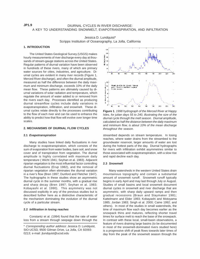
The United States Geological Survey (USGS) makeshourly measurements of river discharge every day at thou-sands of stream-gauge stations across the United States.Regular patterns of diurnal variation have been observedin hundreds of these rivers, many of which are primarywater sources for cities, industries, and agriculture. Di-urnal cycles are evident in many river records (Figure 1,Merced River discharge), and often the diurnal amplitude,measured as half the difference between the daily maxi-mum and minimum discharge, exceeds 10% of the dailymean flow. These patterns are ultimately caused by di-urnal variations of solar radiation and temperature, whichregulate the amount of water added to or removed fromthe rivers each day. Processes identified as producingdiurnal streamflow cycles include daily variations inevapotranspiration, infiltration, and snowmelt. These di-urnal cycles relate directly to the processes contributingto the flow of each river and can be used to enhance theability to predict how that flow will evolve over longer timescales.
2. MECHANISMS OF DIURNAL FLOW CYCLES
2.1 Evapotranspiration
Many studies have linked daily fluctuations in riverdischarge to evapotranspiration, which consists of thesum of evaporation from water bodies, bare soil, and snowcover and of transpiration from vegetation. The diurnalamplitude is highly correlated with maximum dailytemperature ( Wicht 1941; Seyhan et al. 1983). Adjacentriparian vegetation is the most influential factor controllingdiurnal fluctuations (Erup 1982), and the removal ofriparian vegetation often eliminates the diurnal variationin a river’s flow (Bren 1997; Dunford and Fletcher 1947).The hydrographs in these studies show an asymmetricdiurnal cycle in the summer months, with a gradual riseand sharp decay (Bren 1997; Seyhan et al. 1983;Kobayashi et al. 1990). This asymmetry was notdiscussed explicitly in any of the previous studies but isdescribed further here as a distinctive characteristic ofthe mechanism dominating the evolution of the diurnalcycle of a particular stream.
2.2 Infiltration in losing reaches
Constantz et al. (1994) found that the rate of waterloss from a stream through seepage down through the
* Corresponding author address: Jessica D. Lundquist,SIO-UCSD, 9500 Gilman Drive, La Jolla, CA 92093-0213; e-mail: [email protected]
streambed depends on stream temperature. In losingreaches, where water drains from the streambed to thegroundwater reservoir, larger amounts of water are lostduring the hottest parts of the day. Diurnal hydrographsfor rivers with infiltration exhibit asymmetries similar tothose associated with evapotranspiration, with a slow riseand rapid decline each day.
2.3 Snowmelt
Many watersheds in the western United States drainmountainous topography and contain a substantialamount of snowmelt runoff. Snowmelt runoff typicallybegins in early April and may last through July or August.Studies of small basins and local snowmelt documentdiurnal cycles in snowmelt and river discharge that areasymmetric, with sharp daily upward ramps and thengradual recessions (Braun and Slaymaker 1981;Kattelmann and Elder 1993; Kobayashi and Motoyama1985; Jordan 1983; Singh et al. 2000; Caine 1992; andothers). In most of the studies in small watersheds, thetime of maximum flow each day becomes earlier as thesnowpack thins and matures, reflecting shorter traveltimes for surface melt to reach the base of the snowpack.In contrast with these local, small-basin observations, afeature of rivers draining large basins (to be documentedin most of the snowmelt-dominated rivers studied here)is a progressive shift of peak flows towards later times ofday from the peak of the snowmelt season through the
Figure 1. 1998 hydrograph of the Merced River at HappyIsles, for julian days 55 to 240, illustrating the size of thediurnal cycle through the melt season. Diurnal amplitude,calculated as half the distance between the daily maximumand minimum flow, is about 10% of the mean dischargethroughout the season.

period of declining flows (Lundquist etal. 2000).
3. RESULTS
3.1 Amplitude of the diurnal cycle
Hourly discharge rates for the fiveyears from 1996 to 2000 for 100 riversin the western United States were ana-lyzed with a sliding Fourier window 10-days wide, advanced one day at a time.As illustrated in Figure 1, the magnitudeof the diurnal amplitude, calculated ashalf the difference between the maximumand minimum daily discharge and aver-aged over the period being examined,changes with the magnitude of total dis-charge over the course of a year. Theratio of the amplitude of the diurnal cycleto the average total daily discharge is ameasure of the percentage of the dis-charge being added and/or removedeach day. This measurement indicateshow large a portion of the flow is con-trolled by diurnal processes and how themagnitude of diurnal processes changeswith the seasons. The average ampli-tude of the diurnal cycle for high eleva-tion rivers, assumed to be snowmelt-dominated, ranges between 5% and 30%of the average total flow during the meltseason (Figure 2a, 2b, and 2c). For mostrivers, this percentage is largest duringpeak spring flows, when snowmelt con-tributes most to the river. The relativesize of diurnal cycles in the southernCalifornia arid rivers, assumed to bedominated by evapotranspiration and/orinfiltration, increases during the summermonths, when the total flow decreases(Figure 2b, 2c, and 2d).
3.2 Timing of diurnal flow maxima
Streamflows in arid-region rivers consistently reachtheir daily maxima at about 10:00 am local standard time(mid-morning) throughout the summer months. Thistiming reflects water beginning to be removed from thesystem by streambed infiltration, transpiring vegetation,or evaporation during daylight hours, causing a decreasein flow after midmorning.
For snowfed rivers, the times of daily flow maximaduring peak melt tend to be near midnight or in the earlyhours of the morning, reflecting delays in travel time fromthe location of maximum melt the previous afternoon tothe river gauge. A few exceptions occur, including theAnimas River in Colorado, which tends to have amaximum flow near midday.
In addition to the different times of daily flow maxima
between snowfed rivers and arid-region rivers, the patternsof consistency or change in this time over the seasoncan indicate whether water is predominantly added to orremoved from a given basin. Because bothevapotranspiration and infiltration occur along the samefixed length of the river, the travel time between thelocation of the diurnal forcing and the river gage isconstant. Hence, the hour of maximum flow is consistentand does not shift in time as the season progresses. Incontrast, snowmelt generally occurs some distanceupstream from the gauge, and this distance changes asthe snowline retreats, especially near the end of the meltseason. Thus, within-basin travel times exert a largecontrol on the hour of maximum discharge recorded in asnowfed stream. The most universally consistent featureamong the phase of snow-fed rivers is the shift ofmaximum flows to later in the day during the latter portionof the melt season. This shift almost always occurs afterthe peak melt, during the period of declining flows, and
Figure 2. Amplitude of the diurnal cycle,calculated as half the daily maximum tominimum difference, expressed as apercentage of the mean flow. (a) During lowwinter flows, the diurnal cycle of isolated snowmelt is a significant fraction ofthe total. (b) During the peak of the melt season, the diurnal amplitude isabout 10% of the total flow. (c) By the summer, the diurnal cycle is aninsignificant fraction in the snowfed rivers but becomes large inevapotranspiration and infiltration rivers. (d) In September, only theevaporation and infiltration rivers remain. A + indicates a station where theamplitude of the diurnal cycle is less than 5%.

reflects increasing travel times as the snowline retreatsto the highest reaches of the basin (Lundquist 2000).
Figure 3 shows the average change in hour of maxi-mum flow from the beginning to end of July, the end ofthe snowmelt season. Many mountain rivers, presum-ably those that still have snow in July, exhibit black dots,indicating shifts in time of peak flow to later in the day.Most rivers in arid regions exhibit little or no changes intiming.
3.3 Asymmetries of diurnal streamflow cycles
The shapes of diurnal cycles also reflect the processesthat control the daily flow regime in a given river. Wherewater added to the river is the dominant diurnal influ-ence, such as in a snowfed river, the diurnal cycle is char-acterized by a sharp rise and gradual decline (Figure 4a,Merced River). Where water is being removed from theriver, such as arid-region infiltration and evapotranspira-tion, the diurnal cycle is characterized by a gradual riseand sharp decline (Figure 4b, Temecula Creek). Figure 5shows differences in the number of hours each day whenflow is rising and decaying during the months of May and
July in rivers across the western United States. Duringthe peak snowmelt season (Figure 5a), the decay timefor snow-fed mountain rivers is longer than the rise time,while arid-region and coastal rivers have a longer risetime than decay time. Because there is very little precipi-tation at this time of year, most rivers without snowmeltinput are presumably losing water through either evapo-transpiration or infiltration each day. As the summerprogresses (Figure 5b), more rivers shift to having a longerrise time than decay time, reflecting a shift towards wa-ter being removed from the channel daily rather thanadded.
4. SUMMARY AND CONCLUSIONS
The diurnal cycle is a significant component ofstreamflow variation in a majority of the routinely-moni-tored rivers in the western United States and can be usedto understand the dominant physical processes addingwater to or removing water from a given river basin at agiven time. The clearest physical differences are thosebetween water diurnally added to the river, like snow-melt, and water diurnally removed from the river, likeevapotranspiration and infiltration. Snowmelt-dominatedrivers, like the Merced River (Figure 1), have their high-est flows and largest diurnal fluctuations during the springmelt season. These daily fluctuations are characterizedby sharp rises followed by gradual declines. Towardsthe end of the melt season, the hour of maximum dis-charge shifts to later in the day in large basins as thesnowline retreats to higher elevations, farther from thegauge. Evapotranspiration/infiltration-dominated rivershave seasonal maximum flows during the winter rainy
Figure 3. Average shift in the hour of maximum dischargefor the month of July, years 1996-2000. Because July isnear the end of the melt season, peak flows in mostsnowfed rivers shift to later in the day, illustrated by blackdots. Evaporation and infiltration-dominated riversgenerally do not show significant phase shifts, illustratedin southern California. A + indicates a station where thereis no discernable shift in the hour of peak discharge. Forthis calculation, hourly discharge measurements for themonth are broken into six-day segments, advancing byone-day increments. Each segment is Fouriertransformed, and the hour of maximum flow is calculatedfrom the phase of the diurnal and semidiurnal components.A line is fit to the hours of maximum flow over the monthusing least squares analysis, and the slope of the best fitline is considered the average shift.
Figure 4. (a) Normalized flows for the Merced River forseveral days in 1999 illustrate the characteristic snowmelt-forced river asymmetry, with a steep rise and more gradualdecline. Marked days indicate the starting point of each48 hour period, so that day 130 shows julian days 130and 131. (b) Normalized flows for two days in TemeculaCreek exhibit the desert-type river characteristic shape,with a gradual rise and steep decline.

season but exhibit strongest diurnal cycles during thesummer months when discharge is lowest. During thisperiod, the diurnal fluctuations comprise a large percent-age of the total flows. The hour of daily maximum dis-charge occurs in the morning and is consistent betweenrivers and over time as the summer progresses. In thesearid-region rivers, diurnal changes are characterized bya gradual rise and sharp decline.
The present study shows broad patterns and stylesof diurnal flow cycling across the western United States.This broader perspective, once fully exploited, holds po-tential for new methods and understanding to comple-ment previous studies, which have tended to addresssmaller, fewer basis and focus on one hydrological pro-cess at a time. By evaluating records from standardUSGS stream-gauge stations, this study shows that di-urnal characteristics are available for study in many largebasins that are routinely monitored. As diurnal fluctua-tions become better understood, hourly measurementsof discharge may become useful prognostic tools in hy-drological forecasting.
5. REFERENCES
Braun, L. N., and Slaymaker, H. O. 1981: Effect ofscale on complexity of snowmelt systems. NordicHydrol. 12, 235-246.
Bren, L. J. 1997: Effects of slope vegetation removal onthe diurnal variations of a small mountain stream.Water Resour. Res., 33, 321-331.
Caine, N. 1992: Modula-tion of the diurnalstreamflow responseby the seasonalsnowcover of analpine basin. J.Hydrology, 137, 245-260.
Constantz, J., C. L.Thomas, and G.Zellweger 1994:Influence of diurnalvariations in streamtemperature onstreamflow loss andgroundwater recharge.Water Resour. Res.,30, 3253-3264.
Dunford, E. G., and P.W. Fletcher 1947:Effect of removal ofstream-bank vegeta-tion upon water yield,Eos Trans. AGU, 28,105-110.
Erup, J. 1982: Diurnalfluctuations of stageand discharge in theDanish River Suså.Nordic Hydrol. 13,
Figure 5. Diurnal cycle asymmetry, calculated as the difference between the averagediurnal hydrograph rise time (from minimum to maximum discharge) and the decay time(from maximum to minimum discharge) for the months of (a) May and (b) July. (a)During the height of the melt season, all snow-fed rivers have a longer decay time thanrise time, and most of the California desert and coastal rivers have a longer rise timethan decay time. (b) During the height of the summer, as snow runs out, more riversexhibit a longer rise time than decay time, signifying a change between snow-forceddiurnal cycling and evapotranspiration/infiltration-forced diurnal cycling. A + indicates astation where there is no difference between the decay and rise times.
293-298.Jordan, P. 1983: Meltwater movement in a deep
snowpack 1. Field observations. Water Resour.Res., 19, 971-978.
Kattelmann, R. and K. Elder 1993: Accumulation andablation of snow cover in an alpine basin in theSierra Nevada, USA. Snow and Glacier Hydrology.IAHS Publ. No. 218, 297-307.
Kobayashi, D. and Motoyama, H. 1985: Effect of snowcover on time lag of runoff from a watershed. Ann.Glaciol., 6, 123-125.
____________, K. Suzuki, and M. Nomura 1990:Diurnal fluctuations in streamflow and in specificelectric conductance during drought periods, J.Hydrol. 115, 105-114.
Lundquist, J. D., M. Dettinger, and D. Cayan, 2000.Patterns in the diurnal cycle of streamflow in thewestern United States. AGU Fall Meeting. SanFrancisco, California.
Seyhan, E., A. S. Hope, R. E. Schulze 1983: Estima-tion of streamflow loss by evapotranspiration from ariparian zone. South Afr. J. Sci., 79, 88-90.
Singh, P., H. Huebl, and H. W. Weinmeister, 2000: Useof the recession characteristics of snowmelthydrographs in the assessment of snow waterstorage in a basin. Hydrol. Process., 14, 91-101.
Wicht, C. L. 1941: Diurnal fluctuations in Jonkershoekstreams due to evaporation and transpiration. J. S.Afr. For. Assoc., 7, 34-49.