k r o king county, washington...mountain mount si nrca west tiger mountain nrca maury island...
TRANSCRIPT
CarkeekPark
EmmaSchmitz
LincolnPark
GoldenGardens
DiscoveryPark
RicheyViewpoint
City ofDes Moines
Park
S 239th StPark
SNOHOMISH COUNTY
KING COUNTY
KING COUNTY
PIERCE COUNTY
KING COUNTY
CHEL
AN COUNTY
KITTITAS COUN
TY
KING COUNTY
KITSAP CO
UN
TYKIN
G CO
UN
TY
520
522
5
520202
203
509
509
167 515
90
405
405
99
99
99
5
5
900
90
164
18
18
516
169
169
410
2
Lake
Sam
mam
ish
Puget Sound
Skykomish River
Nor
th F
ork
Snoq
ualm
ie R
iver
Mid
dle Fo
rk Sn
oqualm
ie River
S. Fork Snoqualmie River
Cedar River
Green River
Samm
amish
River
ElliottBay
Snoqualmie River
White River
T
olt
Rive
r
Tolt River
Reservoir
Lake
W
ashi
ngto
n
HowardHanson Reservoir
ChesterMorseLake
KIRKLAND
REDMOND
SAMMAMISH
DUVALL
WOODINVILLEBOTHELL
MERCER ISLAND
RENTON
TUKWILA
SEATTLE
SEATTLE
BURIEN
SEATAC
SEATTLE BELLEVUE
ISSAQUAHSNOQUALMIE
CARNATION
NORTHBEND
SHORELINE
FEDERALWAY
AUBURN
KENT
COVINGTON
BLACKDIAMOND
MAPLEVALLEY
VashonIsland
MauryIsland
ENUMCLAW
RattlesnakeMountain
Scenic NRCA
Mount Si NRCAWest TigerMountainNRCA
Maury Island EnvironmentalAquatic Reserve
Cedar RiverWatershed
WASHINGTONSTATE
KING COUNTY
SnoqualmieBog
King’s LakeBog
7464'
7492'
5890'
4167'Mount Si
Federation ForestState Park
Mount Hinman
Red Mountain
Summit ChiefMountai
5763'
3004'
Treen Peak
Tiger Mountain
6278'
7432'
6241'
6261'
6680'
6125'
6190'
6960'
6926'
5395'
5605'
6238'
5135'
5360'
5718'
5680'
5979'
5535'
4773'
5162'
Tinkham Peak
Pyramid Peak
SnowshoeButte
BlowoutMountain
Data Sources: Ecoregions, from U.S. EPA; Marine Protected Areas, from WA Dept. of Fish & Wildlife; Natural Area Preserves, Natural Resource Conservation Areas, Aquatic Reserve, from WA Dept. of Natural Resources; Wildlife Habitat Network, from King County. Wildnerness Areas, from U.S.D.A. Forest Service. Old Growth, from various sources.
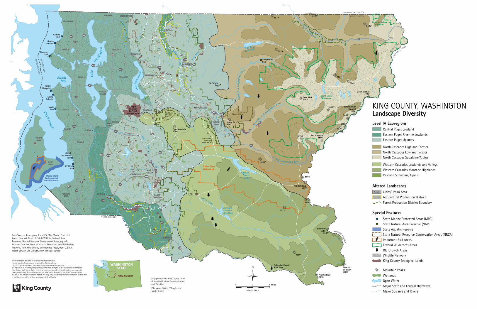
Level IV Ecoregions
Landscape DiversityLandscape DiversityKING COUNTY, WASHINGTON
Cascade Subalpine/Alpine
Central Puget Lowland
Eastern Puget Riverine Lowlands
Altered LandscapesCities/Urban Area
Special Features
Agricultural Production District
Forest Production District Boundary
Eastern Puget Uplands
North Cascades Highland Forests
North Cascades Lowland Forests
North Cascades Subalpine/Alpine
Western Cascades Lowlands and Valleys
Western Cascades Montane Highlands
State Marine Protected Areas (MPA)
State Natural Area Preserve (NAP)
State Aquatic Reserve
Important Bird Areas
Federal Wilderness Areas
Old Growth Areas
Wildlife Network
King County Ecological Lands
State Natural Resource Conservation Areas (NRCA)
Wetlands
Open Water
Major State and Federal Highways
Major Streams and Rivers
Mountain Peaks
The information included on this map has been compiled from a variety of sources and is subject to change without notice. King County makes no representations or warranties, express or implied, as to accuracy, completeness, timeliness, or rights to the use of such information. King County shall not be liable for any general, special, indirect, incidental, or consequential damages including, but not limited to, lost revenues or lost profits resulting from the use or misuse of the information contained on this map. Any sale of this map or information on this map is prohibited except by written permission of King County.
NAME
Map produced by King County DNRP GIS and WLR Visual Communication and Web Unit.
File name: 0801kcECOregions.ai wgab, sk, lpre
0 3 6 Miles
March 2007
N
Alpine LakesWilderness
Henry M. JacksonWilderness
CougarMountainRegional
Wildland Park