kahua a'o geology lesson #2: the evolution of a hawaiian
TRANSCRIPT

1
Kahua A‘o Geology Lesson #2: The Evolution of a Hawaiian Volcano – Handouts
The Life
and Times
of a
Hawaiian
Volcano
Scott K. Rowland, University of Hawai‘i at Mānoa
THE LIFE AND TIMES OF A HAWAIIAN VOLCANO
Hawaiian volcanoes are probably some of the best-studied
in the world. One of their aspects that has long been
recognized, but which is still not fully understood, is how
they evolve from young volcanoes to old seamounts.
Geologists noticed that the volcanoes were obviously
younger at the SE end of the chain, and older at the NW
end. They also noticed that the morphology of the
volcanoes differed, even accounting for erosion. And
finally, when examining an individual volcano it was clear
that older flows and younger flows were not the same.
How these changes work, however, was elusive until the
early 1980s. Remember also that the early attempts to
explain Hawaiian volcano evolution occurred without the
benefit of Plate Tectonic theory.
Satellite
image of the
Hawaiian
Islands
The earliest western geologists noticed that there were
obvious age differences in the islands as one moved from
southeast to northwest. They didn’t have satellite images,
of course, but they could notice the differences from the
surface.
Compilation
of volcano-
order
estimates
Clague & Dalrymple (1987)
Compilation of volcano-order estimates
Lots of folks made estimates of the order in which the
Hawaiian volcanoes had gone extinct, mostly based on the
degree to which they were eroded.
East
Molokaʻi East Moloka‘i, viewed fromthe north.
Also, from early on, geologists noticed that the lower parts
of Hawaiian volcanoes consist of many, relatively thin
lava flows that tend to weather to a red-brown color. The
upper parts, on the other hand, consist of fewer, but
thicker, lava flows that typically weather to a light grey or
white color. This cliff on the north coast of Moloka‘i
illustrates this relationship very well.

2
Waiʻanae
Volcano Wai‘anae Volcano, north side of Nānākuli Valley
Lower flows(thinner, weather to red-brown)
Upper flows (thicker, weather to light grey)
Slide by John Sinton
Another example is Wai‘anae volcano, on O‘ahu.
Lower- &
Upper-style
layers
Photo by John Sinton
Additionally, on some of these volcanoes, there is an
indication that some time passed between the last lower-
style layer and the first upper-style later. For example, in
the photo at left, on Kohala, a soil layer that has developed
on the uppermost of the thin, lower flows, and it was
buried by the lowermost of the thick, upper flows. In the
photo on the right, from W. Maui, there is a soil layer at
the top of the red flows (it is slightly redder), and it
underlies the lowest grey flow. The interpretation is that
the volcano erupts one type of lava throughout most of its
life, pauses (during which time the soil develops), and then
erupts again, but this time producing a different type of
lava. The early observations didn’t offer an explanation of
why there might be these differences or even of what the
differences are, only that they exist.
The
“production
line” model
of Hawaiian
volcano
evolution
The “production line” model of Hawaiian volcano evolution...
Meanwhile, however, what are we talking about here?
Why would we expect a Hawaiian volcano to change its
behavior at all? The answer lies with the relationship
between the ideas of plate tectonics and so-called hot
spots. This is an idea that dates from the early 1960s, and
it was seen as a test of plate tectonics. Namely, if there
was a stationary (and therefore deeper than the plate)
source of magma with a plate moving over it, one should
find a line of volcanoes that is young at one end and old at
the other. Sure enough, that’s exactly what we see in
Hawai‘i. In fact, if you plot volcano age vs. distance from
Lōʻihi, the data produce a relatively good line. Here is a
good place to stop and talk to your students about graphs.
Namely, what is the slope of a graph good for? How do
you calculate the slope? X-axis over Y-axis. Do the units
on the axes matter? Of course. If you calculate x-axis
over y-axis, you also have to calculate x-axis units over y-
axis units. When you do so for the units shown here, you
get distance/time, which is velocity. This is the velocity of
the plate moving over the hot spot.
3
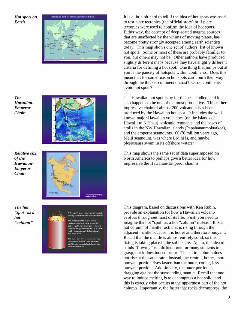
Hot spots on
Earth
Hotspots on Earth (continents seem to avoid them)
It is a little bit hard to tell if the idea of hot spots was used
to test plate tectonics (the official story) or if plate
tectonics were used to confirm the idea of hot spots.
Either way, the concept of deep-seated magma sources
that are unaffected by the whims of moving plates, has
become pretty strongly accepted among earth scientists
today. This map shows one set of authors’ list of known
hot spots. Some or most of these are probably familiar to
you, but others may not be. Other authors have produced
slightly different maps because they have slightly different
criteria for defining a hot spot. One thing that jumps out at
you is the paucity of hotspots within continents. Does this
mean that for some reason hot spots can’t burn their way
through the thicker continental crust? Or do continents
avoid hot spots?
The
Hawaiian-
Emperor
Chain
Hawaiian-Emperorbend (~48 Ma)
Hawai‘i(<1 Ma)
Kaua‘i(5-6 Ma)Pihemanu
(Midway)(~27 Ma)
Nintoku Seamount(~56 Ma)
Meiji Seamount(60-70 Ma)
Puhahonu (Gardner Pinnacles)(~13 Ma)
--
The Hawaiian hot spot is by far the best studied, and it
also happens to be one of the most productive. This rather
impressive chain of almost 200 volcanoes has been
produced by the Hawaiian hot spot. It includes the well-
known major Hawaiian volcanoes (on the islands of
Hawaiʻi to Niʻihau), volcanic remnants and the bases of
atolls in the NW Hawaiian islands (Papahanaumokuakea),
and the emperor seamounts. 60-70 million years ago,
Meiji seamount, was where Lōʻihi is, and maybe
plesiosaurs swam in its offshore waters!
Relative size
of the
Hawaiian-
Emperor
Chain
--diagram by Chuck Blay &
Robert Siemers
This map shows the same set of data superimposed on
North America to perhaps give a better idea for how
impressive the Hawaiian-Emperor chain is.
The hot
“spot” as a
hot
“column”
A "hotspot", as we know it, is an upward-moving cylinder of solid mantle material.
The material in the center movesthe fastest and therefore finds itselfout of equilibrium the most. In turn, it melts to the greatest degree. Volcanoes fed by this part erupt tholeiite basalt and erupt often.
The outer part moves the slowest andonly melts a little bit. Volcanoes fedby this region erupt alkalic basalt anderupt infrequently.
This diagram, based on discussions with Ken Rubin,
provide an explanation for how a Hawaiian volcano
evolves throughout most of its life. First, you need to
imagine the hot “spot” as a hot “column” instead. It is a
hot column of mantle rock that is rising through the
adjacent mantle because it is hotter and therefore buoyant.
Recall that the mantle is almost entirely solid, so this
rising is taking place in the solid state. Again, the idea of
solids “flowing” is a difficult one for many students to
grasp, but it does indeed occur. The entire column does
not rise at the same rate. Instead, the central, hotter, more
buoyant portion rises faster than the outer, cooler, less
buoyant portion. Additionally, the outer portion is
dragging against the surrounding mantle. Recall that one
way to induce melting is to decompress a hot solid, and
this is exactly what occurs at the uppermost part of the hot
column. Importantly, the faster that rocks decompress, the

4
more it melts. Additionally, the more melt that is
produced, the more diluted certain incompatible elements
will be in that melt. The result is that when you compare
the outer and inner portions of the melt region, there will
be differences both in the composition of the melt and in
its volume. Specifically, the center will produce large
volumes of tholeiitic basalt whereas the outer portion will
produce smaller volumes of alkalic basalt.
Tectonic
plate
movement
over the hot
“column”
Next imagine a portion of the Pacific plate moving over
the top of this hot column. The inner and outer melting
portions will be stretched downstream a bit, but there will
still be a somewhat bulls-eye pattern. If you were to
follow an individual location on the over-riding plate, it
would initially not know there was a hot column at all.
Next, it would move over the outer portion of the column,
and small volumes of alkalic basalt would start to work
their way through to feed a small, young, undersea
volcano. After a while, the point that we are following
will move over the interior portion of the column, and
larger volumes of tholeiitic magma will erupt through,
building by far the greatest proportion of the volcano.
Eventually, the point will move off the central portion and
again over a region of low-supply alkalic magma-
production, which, when it erupts, produces a small cap of
alkalic basalt on top of the massive tholeiitic shield.
Finally, the location will move off the hot column all
together, and the volcano will die.
The
“hotspot” as
a “hot
column”
In reality, if the upwelling startsat the core-mantle boundary, thena "hotspot" is more than 10 timesas tall as it is wide.
A “HOTSPOT” IS PROBABLY MORE LIKE A “HOT COLUMN”
The size of the column is quite speculative, but based on
the area of uplifted lithosphere around Hawaiʻi, it is
probably around 250 km across. If, as some have
suggested, the entire mantle convects, then the height is
about 3000 km. It is a pretty long, skinny column.
Seismic
Tomography
NATURE|VOL 421 | 2 JANUARY 2003 |www.nature.com/nature
http://www.higp.hawaii.edu/~cecily/plume.nature.pdf
DIAGRAM SHOWING HOW SEISMIC WAVES FROM DISTANT EARTHQUAKES
PASS UPWARDS TO HAWAI‘I SEISMOMETERS. IF THEY DON’T PASS THROUGH
HOT ROCK, THEY ARRIVE WHEN EXPECTED. IF THEY DO PASS THROUGH
HOT ROCK (I.E., THE HOTSPOT) THEY ARE SLOWED AND ARRIVE LATE.
Recent work by Cecily Wolfe, at UHM, used a technique
called seismic tomography to detect the column (which
she calls the plume conduit). She and her co-workers set
out a huge array of seismometers, and compared the
arrival times of the same earthquake at different locations.
Waves that travel through hotter rock are slowed down
relative to those that pass only through cooler rock. By
mapping all the different paths, Cecily came up with a
map of where the mantle is hotter.

5
Seismic
Tomography
SEISMIC TOMOGRAPHY DATA SHOWING ANOMOLOUS
SLOWING OF S-WAVES UNDER HAWAI‘I. THE INTER-
PRETATION IS THAT THESE WAVES ARE SLOWED BY THE
PRESENCE OF ANOMALOUSLY HOT ROCK (THE HOTSPOT)
Wolfe et al. (2009), Science vol. 326, pp. 1388-1390
These are some of her data, shown as slices at different
depths. The colors indicate what is called the s-wave
anomaly, which means the difference between measured s-
wave velocity and expected s-wave velocity (s-waves are
one of two types of earthquake waves that pass through the
body of the earth, and they are particularly susceptible to
variations in the rigidity of rock, making them ideal for
this technique). The data show that at least as far as 400
km below the surface, there is an obvious region of
negative velocity anomaly (almost certainly due to the
rock being hotter).
Life Stages
of a
Hawaiian
Volcano
adapted from Peterson & Moore (1987)
With or without the plate-tectonic/hot spot understanding,
the typical order of events on a Hawaiian volcano has been
derived. It is important to remember that these are human-
defined steps – the volcanoes couldn’t care less about
them. Some volcanoes skip certain steps, some stay in a
particular step for a long time whereas others only briefly.
In fact, it is the variability that makes studying this process
so interesting. As is diagrammed here, a typical Hawaiian
volcano starts its life as a small seamount, and ends its life
as a small seamount. Along the way it grows, becomes
very active, then slowly dies off. A few briefly rejuvenate,
but all eventually stop erupting, and erode and subside
below sea level.
Stage 1:
Submarine
Alkalics
-melting is just getting going
-alkalic basalt composition
-water pressure prevents explosive activity
-no current Hawaiian examples
The very first stage in a Hawaiian volcano’s life is
somewhat conjectural. We know from the hot-column
model that the first melts that a point on the lithosphere
encounters will be alkalic, and we also know that the
magma-production rate will be small.
Stage 2:
Submarine
Tholeiite
-magma production becoming more efficient
-tholeiite composition
-water pressure prevents explosions
-caldera and rift zones developing
-Lō‘ihi
As the now-established volcano moves closer to the center
of the hot column, both the magma composition and
magma supply rate increase. Tholeiite lavas are erupted,
and they bury the early alkalic lavas. On Lōʻihi, the only
Hawaiian example currently in this stage lavas sampled
from the summit and upper flanks are tholeiite whereas
those sampled from the lower flanks are alkalic. Lōʻihi,
therefore, hasn’t yet completely buried its early alkalic
base.

6
First
Bathymetric
Map of
Lōʻihi
The first bathymetric map to show (but not identify) Lō‘ihi
Stearns HT (1946) Geology of the Hawaiian Islands. Hawaii Div Hydrography Bulletin 8
The human history of Lōʻihi is an interesting story. The
first bathymetric map to show Lōʻihi was published in
1946.
Earthquake
Data
Earthquake data from March and April, 1952, young volcano idea first proposed
Macdonald GA (1952) The South Hawaii earthquakes of March and April, 1952.
The Volcano Letter 515:3-5
“Submarine contours…show a broad dome with its apex 21 miles nearly due south of the
summit of Kilauea volcano…This dome is probably a shield volcano, lying against the side
of the Kilauea shield just as Kilauea does against the side of Mauna Loa.”
In 1952, Gordon Macdonald proposed that perhaps it was
the youngest Hawaiian volcano. His idea was based on
Lōʻihi’s location (next in line SE of Kīlauea) as well as the
fact that there were commonly earthquakes in its vicinity,
although the sparse seismometer network at the time could
not pinpoint those earthquakes very well.
Lōʻihi gets a
name
Lō‘ihi gets a name
“One of the seamounts (Wini – “coming to a point, sharp pointed”) is conical in shape,
one (Loihi – “to extend, to be long”) is elongate, one (‘Apu‘upu‘u – “a rough, uneven
surface, such as a hillock” is irregular with several peaks, and the other two smaller ones
(Hohonu and Papa‘u – “to be shallow, as water”) are of uncertain shape, possibly conical”
Emory KO (1955) Submarine topography south of Hawai‘i. Pacific Science 9:286-291
In 1955, Kenneth Emory named Lōʻihi based solely on its
form (elongate) in map view. He named a bunch of other
seamounts using the same system.
Lōʻihi gets a
name
‘Keiki ‘ehu kama ‘ehu a Kanaloa,’”
she explains. “‘The reddish child,
the reddish child of Kanaloa,’
who is the deity of the ocean.”
Hānau Ka Moku, a chant by
Hālau O Kekuhi
Not everyone likes the name Lōʻihi, nor the fact that it was
named without consultation with the people who live
closest nearby. They instead call it Kama ‘ehu, the red
child.
Earthquakes
between 1970
– 1983
Earthquakes between 20 and 24 km depth from 1970 to 1983
(Klein et al. 1987)
As the seismic network on Hawaiʻi got better, the ability
to pinpoint earthquakes also improved, and it was clear
that whatever Lōʻihi was, it was often seismically active.
Additionally, an oceanographic cruise in the late 1970s
happened to dredge a sample from Lōʻihi’s summit, and it
turned out to be very young-looking basalt. After a
particularly noticeable seismic swarm in late 1987, NSF
funded a joint UH/Woods Hole rapid-response cruise
using the submersible ALVIN.

7
Pillow Lava
pillow lavas on Lō‘ihi, viewed from the ALVIN submersible
At Lōʻihi, we found young pillow lavas, warm water, and
very high CO2 concentrations in the water. The young-
volcano interpretation was proved correct. In April 1996
Lōʻihi erupted, and in July of the same year, it produced
the largest seismic swarm ever recorded on a Hawaiian
volcano. Apparently what happened was the eruption
emptied the shallow magma chamber. The volcano
managed to hang on for about 3 months until July, when
the summit collapsed to produce a deep pit. The seismic
swarm recorded this collapse. Pillow lavas are essentially
under-water pahoehoe. You might think that under-water
eruptions should be really explosive (hot lava + water ‘n
all), but they are not. The reason for this is that at these
depths, water pressure prevents water vapor from forming,
and therefore there are no explosions.
Talus on the
flanks of
Lōʻihi
talus on the upper flanks of Lō‘ihi, viewed from ALVIN
The flanks are quite steep, and covered with talus.
Bathymetry
of Lōʻihi Bathymetry of Lō‘ihi,
compiled by the Hawai‘i
Mapping Research Group riftzones
filledcaldera(?)
Bathymetrically, Lōʻihi is obviously elongate, has a
relatively flat summit, and very steep flanks. It appears to
have two rift zones, and the summit has the appearance of
a very shallow caldera, which is basically filled to the
brim. A caldera so early in life means that it also has a
magma chamber early in life (there has to be something to
collapse into).
Stage 3:
Shallow-
water
hyaloclastites
-high magma production rate continues
-shallow water depth no longer prevents explosive activity
-no current Hawaiian examples
When the summit of the volcano reaches to about 200 m
below the surface, the water pressure is no longer
sufficient to prevent explosive lava-water interactions, and
the eruptions change from passive effusion of pillow lavas
to strong steam explosions. These explosions occur every
time the volcano erupts as it builds itself from ~200 m
below sea level to above sea level. After that it erupts
lavas again. There is therefore a ~200 m-thick layer of
hyaloclastite (black sand and rubble) sandwiched between
pillow lavas below and subaerial lavas above.

8
Nuku’alofa
eruption,
Tonga,
March 2009
Nuku‘alofa eruption, Tonga, March 2009
http://deems.files.wordpress.com/2009/03/bigpicture_2009_03_volcano.jpg
Violent interaction of erupting magma and shallow ocean water
The eruptions during this stage of a Hawaiian volcano’s
life probably look something like this. Vigorous mixing
between rapidly expanding magma and water occurs,
leading to violent steam explosions. The particles rain
back down to produce a blanket of unconsolidated
fragmented material. The geologic term is hyaloclastite,
but normal people call it black sand.
Stage 4:
Main
Tholeiite
Shield
-magma production rate at highest level
-alternating infilling and re-forming of caldera
-‘a‘ā and pāhoehoe flows
-Kīlauea and Mauna Loa
Eventually the volcano gets past sea level, moves over the
center of the hot column, and thereby starts producing
large volumes of tholeiite basalt. This is the stage during
which the great majority of the volcano’s volume is
produced. This is also the eruptive stage that we
understand the best because both Mauna Loa and Kīlauea
are in this stage, and they have each erupted many times.
Mauna Loa,
viewed from
Kīlauea
Mauna Loa, viewed from Kīlauea
The volcano during this stage achieves the classic “shield”
shape, with frequent, high-volume eruptions of fluid lava.
The fact that it is fluid means that it cannot pile up steeply,
but instead, runs easily down the slope. The fact that the
eruptions produce large volumes means that even if the
vent is near the summit, material will also be added to the
flanks, also helping to keep the slopes gradual. Finally,
because there is a shallow magma chamber in this stage, as
we’ll see in a moment, the magmas that erupt have had a
chance to stall for a while and lose some of their dissolved
gas. This means that lava fountains are somewhat reduced
and thereby don’t produce huge cinder cones – the shield
profile is preserved.
Puʻu ʻŌʻō,
Kīlauea,
April 1985 ~400 m-high fountain,
Pu‘u ‘Ō‘ō, Kīlauea,
April 1985
Despite the “reduced” gas, however, eruptions during this
stage can be spectacular.

9
Topography
of Mauna
Loa’s SW
rift zone
Topography of Mauna Loa’s SW rift zone (dark flows post-date 1778)
One of the major volcanic structures on a typical Hawaiian
volcano is rift zones. It is rift zones that make Lōʻihi
elongate, and therefore gave it its name, however, as with
many things, it is the subaerial examples that are
understood to a much greater degree. This is a computer
rendition of Mauna Loa’s southwest rift zone, with post
1778 flows shown in black. Note that if you trace them up
to their sources, all those sources lie along the axis of a
ridge that runs from upper right (near the summit) to lower
left. This ridge is the axis of the rift zone. This image has
been vertically exaggerated, and the slopes are actually
much more gradual. Hawaiian volcanoes either erupt at
their summit or along one of their rift zones, and rarely
anywhere else.
Lava Flow
Hazards
IS THERE A NON-
GEOLOGY REASON
TO CARE ABOUT THE
FACT THAT FLANK
ERUPTIONS ON
HAWAIIAN VOLCANOES
ALMOSTALWAYS OCCUR
FROM RIFT ZONES?
Of course !!
This lava-flow hazard map shows that the highest hazards
occur along the active rift zones of Kīlauea and Mauna
Loa, with lesser hazards downslope from these.
Kīlauea
Caldera
Kīlauea caldera:
Complex caldera-
boundary faults,
and Halema‘uma‘u,
(H) an intra-caldera
pit crater 1954 lava flow
H
The other major volcanic structure that has been studied
considerably at Mauna Loa and Kīlauea is summit
calderas. In some older evolution schemes for Hawaiian
volcanoes, there was a specific “caldera” stage, coinciding
with the main shield stage. We now know, however, that
each Hawaiian volcano has had many calderas during its
life time. At a caldera there is a constant struggle between
collapsing, which enlarges the caldera, and infilling, which
shrinks it. It just so happens that both Kīlauea and Mauna
Loa are in stages where calderas are obvious.
The summit
caldera of
Mauna Loa
~5 km
Vertical air photo of
Moku‘āweoweo, the summit
caldera of Mauna Loa.
Note flows truncated by
caldera margin.
Note that if we were to have visited Mauna Loa some 700
or so years ago, we would have found no summit caldera
at all. At that time, it had infilled completely, and lava
flows were spilling out in all directions. Some of these
flows can be seen in this vertical air photo, and note that as
you trace them uphill, you end up at the caldera rim before
you ever get to their source vents. This means that those
vents were once above what is now the caldera floor, and
have since collapsed in and been buried by later lavas.

10
Magma
Chamber
Processes
Magma chamber processes, as long as there is sufficient supply to
keep the magma chamber from solidifying
A caldera, even one that periodically comes and goes, is an
indication of an active magma chamber. Most of the time
Hawaiian magma chambers are drawn as simple balloons,
but almost certainly they are complex inter-connected
voids rather than one single void. Two important
processes occur within a magma chamber. The first is that
olivines crystallize out of the magma and sink to the
bottom. The magmas thereby “evolve” because the
olivines preferentially take away Mg and Fe relative to Si.
The second important process, mentioned earlier, is that as
magma sits in the magma chamber, gases exsolve and
escape. This reduces the explosivity of Hawaiian
eruptions somewhat compared to what they would be like
if the magma came all the way from where it is generated
and didn’t lose any gas along the way.
Stage 5:
Post-shield
Alkalics
-volcano moves off hotspot
-magma production declines
-alkalic composition of magma
-magma chamber solidifies
-Hualālai, Mauna Kea
Eventually the volcano moves off the central part of the
hot column, into the down-stream portion where low
volumes of alkalic magmas are produced. The total
volume of these lavas is small compared to the volcano as
a whole, and it is often likened to a “cap” of alkalics. In
older texts, it was often referred to as the alkalic “cap”.
Now days, we refer to it as post-shield alkalics.
Mauna Kea,
viewed from
Hilo airport
Mauna Kea, viewed from Hilo airport.
Mauna Kea is a good example of a Hawaiian volcano in
the post-shield alkalic stage. Viewed from Hilo, its profile
is very different from that of the classic, smooth, gentle
Mauna Loa. There are two reasons why the volcano
becomes bumpier and steeper.
Mauna Kea,
viewed from
Mauna
Loa:
magma
chamber
processes
Mauna Kea, viewed from Mauna Loa
solidified magma chamber
erupting magma makes thewhole journey w/o stopping
erupting lava has all it’soriginal gas content andhas cooled
The bumpiness is due to the presence of very large cinder
cones. These large cones are the product of very high lava
fountains, indicating higher amounts of gas as compared to
the volcano in its tholeiite stage. This higher amount of
gas can be tied directly to the lack of a shallow magma
chamber. As the volcano moves off the hot spot the
supply rate drops and the magma chamber is not
replenished often enough to prevent solidifying all
together. This means that there is no shallow place within
the volcano for rising magmas to stop for a while and de-
gas. If they are going to erupt, they will pass from the
source region (or a deeper magma chamber) to the surface
all in one trip. With no chance to lose gas, the lava
fountains are especially high, and this produces large
cinder cones. Additionally, the lack of supply means that
there are no conduits within the volcano for the magma to
utilize. It needs to cut its own pathways through the
volcano, and in so doing it cools and becomes viscous.

11
Viscous lavas can hold a much steeper slope, so this
contributes to the overall steepening of the volcano.
Map of the
ground
slope
In this map of the ground slope, it is obvious that Mauna
Loa and Kīlauea, the two volcanoes in the main tholeiite
shield stage, have much lower average slopes than do
Hualalai and Mauna Kea, the two volcanoes that are in
their post-shield alkalic stage.
Hawaiʻi,
viewed from
Maui
Hawai‘i, viewed from Maui
Mauna LoaMauna Kea
Kohala
Hualālai
From Maui, the different profiles are easy to compare.
East
Molokaʻi
Post-shield alkalic flows (thicker, weather to light grey)
Main-shield tholeiite flows(thinner, weather to red-brown)
East Moloka‘i, viewed fromthe north.
Old volcano surface
The result, as again seen here on Molokaʻi, is a stack of
very many think tholeiite flows below, “capped” by a few
alkalic flows above. The most common mineral in the
tholeiite flows is olivine, and when it weathers, the iron in
it oxidizes, giving the familiar red-brown color. In most of
the alkalic basalts, the most common mineral is
plagioclase feldspar, and when it weathers, it turns from
clear to white.
Stage 6:
Erosion,
reef-
building
-volcano moves off hotspot
-erosion becomes dominant geological process
-extensive reefs develop
-Kohala
At some point the volcano moves far enough off the hot
spot so that it is not supplied by magma at all. Erosion
becomes the dominant geologic process, and extensive
reefs are able to develop because they are no longer being
buried by lava entering the ocean.

12
Mauna
Kea’s lower
NE flank
Mauna Kea’s lower NE flank
It is important to notice, however, that the volcano doesn’t
just shut off completely one day. Instead, there is a slow
decline in eruption rate accompanied by a slow increase in
erosion rate, with both processes operating simultaneously.
Laupāhoehoe
Mauna Kea Laupāhoehoe, Mauna Kea
peninsula formed from lava
that flowed down a large
stream valley
An excellent place that represents this interplay is
Laupāhoehoe, on the flanks of Mauna Kea. Here, the
eruption rate has dropped so that large gullies have been
cut by flowing water. Eruptions at Mauna Kea haven’t
died off completely, however, and a few 10s of thousands
of years ago, a lava flow happened to flow into the upper
reaches of a water-cut valley. Like any fluid would, the
lava utilized the stream valley and flowed to the coastline
and into the ocean.
Waipiʻo and
Waimanu
valleys,
Kohala
volcano
Waipi‘o and Waimanu valleys, Kohala volcano
rapid erosion produces amphitheater-headed valleys
Erosion, particularly by streams, dissects the otherwise
relatively smooth profiles of Hawaiian volcanoes. A
process called stream piracy leads to the situation where
there are a few very large valleys and lots of small ones.
Reef
development
Extensive reef development
on the S coast of East
Moloka‘i
Once lava flows stop entering the ocean all the time,
extensive reefs are able to develop along the fringes of a
volcano.
Erosional
processes
N coast of E. Moloka‘i
In addition to slow erosional processes, there are also
catastrophic events. The north coastline of Molokaʻi has
figured prominently in the recognition and understanding
of these catastrophic events.

13
What
caused the
huge pali? Dana (1890) “Thus such precipices are rather the rule in the Hawaiian group; and if seashore
erosion is not the origin, - as many facts from the islands of the Pacific appear to show, -
fractures and subsidence must be.
WHAT CAUSED THE HUGE PALI? FAULTING? MARINE EROSION?
VALLEY EROSION? SOME COMBINATION OF THESE?
High pali are pretty hard to miss, and back in the late
1800s, JD Dana, an American geologist, speculated about
how they might have formed. He considered that they
might be fault scarps or that they might have been formed
from erosion.
Formation
of a cliff
Formation of a cliff (that might be, or has been, mistaken for a
fault or avalanche scarp) by coalescence of amphitheater-headed
valleys
(Modified from Stearns & Vaksvik 1935)
This series of diagrams shows how a line of cliffs can
develop when the headwalls of several large amphitheater-
headed valleys merge.
Nuʻuanu
pali
An obvious example of this is the Nuʻuanu pali. Remnant
ridges, such as the two that drop down from Konahuanui,
indicate that valley coalescence is what produced this
“linear” pali.
Giant
underwater
avalanches
after Moore (1964)
Based on newly-released bathymetric charts, a USGS
geologist named Jim Moore proposed that giant
underwater avalanches had occurred off the NE and N
coasts of Oʻahu and Molokaʻi, respectively. Landslides
have a classic shape, namely a steep, usually arcuate
headwall, and a run-out region of disorganized lumps,
known as hummocky topography. These Hawaiian
avalanches share these morphological characteristics, but
they are huge. Moreover, Jim Moore observed that the
debris portion extends down the flanks of the two islands,
across what is called the Hawaiian Deep (formed by
down-bowing of the oceanic crust by the weight of the
islands), and up the other side. The avalanche material
therefore moved uphill by 700-800 meters, under water!
The only way for this to have happened would be for them
to be moving quickly. These were therefore not slow,
creeping landslides, but instead, catastrophic avalanches.
Geologists are trained from birth that it is not fair to
explain things with catastrophes, and Moore’s idea was
not readily accepted.

14
Giant
underwater
avalanches
from Moore et al. (1989)
In the early 1980s, due to demands from Ronald Reagan
that the US know what is within its 200-mile territorial
waters, all the offshore was mapped using sonar. They
found a lot more giant underwater avalanches, and it soon
became apparent that these are relatively common, and
must be part of the life cycle of most Hawaiian volcanoes.
Most of these were true avalanches, with the material
moving catastrophically downward and outward, and
breaking up as it moved. Off two volcanoes, however, the
motion is much more subdued. Specifically, Waiʻanae and
Kīlauea seem to have instead moved by coherent slumping
of huge blocks.
Giant
underwater
avalanches
after Moore (1964)
obvious cliffs
actual
avalanche
scarps
Moore proposed that the Nuʻuanu pali and N. cliffs of
Molokaʻi are the headwall scarps of the giant avalanches.
However, there are some geological reasons why this
cannot be the case. Specifically, Olomana, the Keolu hills,
and Mokulua islands are all parts of the pre-avalanche
Koʻolau volcano, and they are in place. If the pali (that is
landward of all of these) were the landslide scarp, there is
no way that they could still be there. We now consider
that the scarps of the landslides are offshore, where there
are obvious “bites” in the edge of a wide under water
shelf. The edge of this shelf is at a depth of ~200 m, and
at the time of the Nuʻuanu avalanche, was probably just
offshore. The avalanches therefore may have taken place
wholly under water. What then, of the obvious Nuʻuanu
pali and N. Molokaʻi cliffs. Probably the removal of the
submarine volcano flanks destabilized the remainder of the
volcano, accelerating smaller-scale erosion, and producing
pali via the headwall-merging scenario mentioned earlier.
Weaknesses
within the
volcano
potential giant avalanche
slide-plane
Why would a volcano fail in the first place? This is an
unanswered question. One potential weakness within the
volcano is that layer of hyaloclastite, which, as you’ll
recall, is left over from the time during which the volcano
was transitioning from submarine to subaerial. The
products during that time are poorly consolidated, and
although they end up being sandwiched between coherent
pillow lavas below and coherent ‘a’a and pahoehoe lavas
above, it is still a weak layer.
Tsunamis
produced as
a result of
giant
avalanches
A deposit of coral and basalt boulders resting ~conformably
on basalt flows, ~100 m above sea level, S. coast of Lāna‘i
An obvious next question is if these avalanches are
catastrophic, what kind of tsunami will they generate?
This is an unanswered question, which unfortunately has
taken on a life of its own in the pseudo-science Discover
TV world. Jim Moore and his brother George mapped a
strange unit of large coral and basalt boulders along the
south coast of Lanaʻi. They followed the deposit inland to
about 100 m elevation, and interpreted it to be the deposit
of a giant tsunami caused by a giant avalanche off the W.
flank of Mauna Loa. They considered that the tsunami
waves would radiate outward in all directions from the W.

15
Mauna Loa source, and would therefore approach Lanaʻi
from the south.
Tsunamis
produced as
a result of
giant
avalanches
The boulders are sorted
by age:
~1 m
Different sea levels?
Multiple tsunami?
Ken Rubin, in our department, led a study that collected
age information on clasts within this so-called Hulopoe
gravel. They found that the boulders are sorted by age.
Specifically, boulders that are around 130,000 years old
are only found from the coast up to about 20 m above sea
level. Boulders ranging in age from 200,000 – 250,000
years in age are found from the coast all the way up to 60
m above sea level. They could think of no mechanism by
which a tsunami could sort boulders by age, and instead
suggested that the deposit is instead the result of multiple
episodes of higher sea level.
Geochemstry
of Hawaiian
rocks
From: http://faculty.plattsburgh.edu/mary.rodentice/courses/
petrolpresent/Ch%2010%20Magma%20Generation%20%2707.pdf
Pretty soon geochemists analyzed a number of Hawaiian
rocks, and realized that there were chemical differences
between the lower, thinner flows and the upper, thicker
flows. In particular, the lower flows are what is called
tholeiite basalt (or tholeiitic basalt) and the upper, thicker
flows are what is called alkalic basalt. Fresh samples of
tholeiitic and alkalic basalt look pretty much identical to
normal people, but their subtle geochemical differences
turn out to be the key to unraveling the evolution of
Hawaiian volcanoes. The differences between the two
types of basalt were defined based on theoretical pressure-
temperature calculations as well as laboratory
experiments. These didn’t contribute a lot toward our
understanding of what might be going on within a
Hawaiian volcano, however. Experiments in the 1960s
showed that the composition of the first melt that comes
out of a heated rock will be different depending on the
pressure. The little red dots show the initial melt
composition on what is called a ternary plot. At a pressure
of 1 atmosphere, the composition will be tholeiitic basalt.
If the melting occurs at higher temperatures, the first melt
has a composition of alkalic basalt. This led to the
reasonable conclusion that as a Hawaiian volcano ages, the
depth at which melting occurs decreases. Shallow melting
early on produces the lower sequence of thin-bedded
tholeiitic basalts, and deeper melting as the volcano dies
off produces the upper sequence of thicker-bedded alkalic
basalts. There was one other way to produce different
types of basalt, however, and understanding of this other
mechanism didn’t occur until the 1980s.