karachi: the transformation and spatial politics of a post-colonial
TRANSCRIPT

SSS10 Proceedings of the 10th International Space Syntax Symposium
S S Khan & K Karimi Karachi: The transformation and spatial politics of a Post-colonial migrant city.
107:1
Karachi:
The transformation and spatial politics of a Post-colonial migrant city.
Sadaf Sultan, Khan Space Syntax Laboratory, Bartlett School of Architecture, UCL, [email protected] Kayvan, Karimi Space Syntax Laboratory, Bartlett School of Architecture, UCL, [email protected]
Abstract
The partition of the Indian Sub-continent in 1947 resulted in the mass movement of people between India and Pakistan with a number of Urdu-speaking, Muslim communities choosing to re-settle in Karachi, Pakistan. These Muhajir or “refugee” communities have now been resident in the city for over 60 years and whilst the term traditionally means “refugee” in Urdu- their mother-tongue- in the context of Karachi today, it refers specifically to the descendants of these first wave (Partition, 1947) Urdu-speaking migrants from India. The community was initially seen as a landless, rootless people but, over time, they have become one of the key actors in the ethno-political landscape of urban Sindh, in Pakistan today. Whilst the political exploits of this community have been extensively reported and documented by anthropologists and journalist as part of Karachi’s tumultuous political history, little has been written about the settlements and spatial practices of this amalgam of diverse, primarily North Indian migrant communities and how their arrival, and occupation has impacted and transformed the manner in which the city has developed. Using space syntax analysis and information drawn from master-plans, urban development reports, historical accounts, and political, religious and linguistic identity-markers associated with the Muhajir community, this study analyses how the city of Karachi has grown and developed through the last 65 years of its post-Partition history and tracks the settlement patterns of the Muhajir community into and around the city. The study shows that, whilst Karachi may be considered a Muhajir city, the community established clusters in very specific areas of the city at the time of their first settlement in the early 1950s and, whilst newer areas have been added to the city, these community-based clusters have persisted and densified over time. The manner in which the community has consolidated and marked its spaces in the city and the way their presence has impacted its growth seems to suggest that the community’s identity has gone through a process of transformation and concretisation from Muhajirs as disadvantaged refugees to Muhajirs as a formidable ethnic group with considerable political clout that they exercise with regard to decisions that pertain to the growth and development of the city today.
Keywords
Karachi, Muhajir, migrant, clusters, ethno-politics.

SSS10 Proceedings of the 10th International Space Syntax Symposium
S S Khan & K Karimi Karachi: The transformation and spatial politics of a Post-colonial migrant city.
107:2
1. Introduction
Karachi today is essentially a city of migrants both domestic as well as international. This has been the outcome of successive waves of in-migration triggered by political decisions taken at both the national and international scale. Of these, possibly one of the most significant events that has been critical to the making of modern Karachi was the Partition of the Indian Sub-continent in 1947. This resulted in the mass movement of peoples across borders, with over a million refugees arriving in Karachi as the city became the new Federal Capital of Pakistan. It has been said that the sheer volume of these refugee communities or Muhajireen- primarily Urdu-speaking, North Indian, Muslim migrants - transformed the character of the city (Siddiqi, 2008).
Within the spectrum of various ethnic groups that make up Pakistan’s population, the Muhajir community have been considered a landless, rootless minority group due to their historic associations with cities in modern day India, as a result their presence and stake in Pakistan has often being suspect. Simultaneously, they enjoy a majority status in urban centres like Karachi and Hyderabad in the Southern province of Sindh. This has resulted in a socio-political attitude that speaks of a community in a constant state of threat, fighting for their space and stake in the city. This paper addresses the spatial aspect of this socio-political outlook; i.e. notions of minority clustering and segregation in the urban context.
Minority clustering is a complex phenomenon, often the combination of forced separation by the majority group of “the other” to maintain a sense of “purity” (Sibley, 1995; Sennet, 1996) as well as chosen segregation by the minority for the purposes of socio-cultural preservation (Werbner, 2005). The location, persistence and densification of the ethnic enclave may be determined by market forces pertaining to affordable housing (Phillips, 2006) and proximity to employment (Charalambous & Hadjichristos, 2011), or to security and safety in numbers resulting in an inversion of power within the enclave in favour of the minority (Peach,1996).
Within this theoretical context, this study analyses whether the Muhajir community is actually clustering in the city? If so, where are these clusters located, and whether there is socio-political significance to this communal clustering as the community’s political clout has increased in the city?
The hypothesis being that despite their varied geographical backgrounds, the Muhajir community have in-fact clustered in certain localities of the city. These clusters have developed, densified and expanded as the community’s self-image has developed taking on a political bent that has become a tangible feature of their spatial dynamic and the manner in which they interact and adapt the city where power and circumstance allow.
This paper will begin by presenting the data and methodologies used for this study followed by a brief historical overview of the Post-Partition political and developmental events that have shaped both the city and the community. It will go on to show where the Muhajireen reside today and what the socio-spatial impact of their political mobilisation and domination has been on the city.
2. Data and methodology
Earlier Syntax studies have shown interesting correlation between spatial segregation, and informal inner city settlements (Karimi et al, 2007), deprivation (Vaughan et al, 2005), unequal urban development and public space use (Legeby, 2009), crime (Zako, 2009), and ethnic distinctions (Raman, 2003; Ferati, 2009). This paper will attempt to show that, in the case of Karachi, there is a relationship between spatial clustering and segregation and political power and mobilisation.
Seeing as this is a study on the spatial dynamics of a community known primarily by its ethno-political identity today, it was important to firstly identify whether there is in-fact a correlation between political activity and the spatial planning and development of the city. This was done through a process of plotting the city’s political and developmental histories and identifying clusters of activity and temporal overlaps. This exercise showed that periods of intense planning and

SSS10 Proceedings of the 10th International Space Syntax Symposium
S S Khan & K Karimi Karachi: The transformation and spatial politics of a Post-colonial migrant city.
107:3
development often coincided with periods of intense political activity thereby identifying critical periods in Karachi’s development and political histories.
The research environment in Pakistan is one where ethnographic data is sparse, and official documentation such as census data is broad and out dated. Findings from the last census that was held in 1998 were published at the scale of the city district
1. As a result, innovative ways of mapping
the city and the Muhajir community’s spatial behaviours had to be developed. This resulted in a mapping methodology that combined data taken from official urban planning documents, historical maps and accounts and anthropological studies, along with the use of spatial proxies; map-able culturally specific identity-markers that pertain to the Muhajir community’s linguistic, religious and political characteristics. Whilst language is not necessarily a tangible urban feature in this particular case, elements such as mosques and political affiliation/presence are; communal institutions such as mosques and political party offices serving sections of this community have an identifiable presence within the city’s urban fabric, the specificities of which will be discussed further in this paper. Information for the latter was taken from census data, open content mapping projects like google earth and Wikimapia as well as observations and documentation carried out in the field during the summer of 2013.
Using the above mentioned forms of data and analysis, a series of maps showing the chronological development of the city’s spatial networks at key points in its development history were modelled. Through GIS mapping, it was possible to geo-reference and map the communal institutions mentioned above and overlay them on the spatial network of the city as it stands today. These individual categories of religious and political elements were combined to form a collective entity and a GIS ‘hotspot’ analysis was used as a means of giving a map-able spatial form to the social impact of these cultural entities. This method was used to define both the larger Muhajir majority area at the scale of the city as well as further identify concentrations of Muhajir communal activity at the neighbourhood scale.
In order to begin to deconstruct the relationship between spatial configuration, ethnic clustering, and the strategic positioning of a community within the fabric of the city, the individual communal institutions, Muhajir majority areas, and Muhajir concentrations or centres were overlaid on the syntax map of the city’s spatial network. Hence relating space syntax analysis to the GIS mapping of the community’s identity-markers has been used to develop a socio-spatial profile for the Muhajir community in the city.
3. Historical background
At Pakistan’s creation, Karachi became the new federal capital; migrants came flooding into the city occupying whatever empty buildings and vacant plots they could find in and around the city centre. Squatter settlements sprang up both in inner-city neighbourhoods as well as in peripheral areas and relief and transit camps were established by the State in then peripheral areas of the city (Gayer, 2014) Figure 01a. This influx of new arrivals and the movement out of Karachi’s Sindhi speaking Hindu community resulted in a cultural transformation of the spaces of the city; tea houses, bookshops and eateries selling specifically North Indian delicacies mushroomed in the city’s downtown areas (Ansari, 2005).
The unpreparedness and inability of the State to speedily rehabilitate refugees, the emergence of the Urdu press as a vocal advocate of Muhajir rights, and the general discontent amongst the refugee population resulted in riots in the 1950s. This propelled Ayub Khan’s
2 government to
propose the Greater Karachi Resettlement Plan (GKRP) in 1958. This proposed the development of satellite industrial townships inclusive of residential units; New Karachi to the north and Landhi-Korangi to the east established at a distance of 20km from the city centre, housing residents of the inner city squatter settlements that had been bulldozed after the riots. The State also planned well
1 For the time period in which this analysis was carried out, Karachi, a city of over 18 million was divided into 5
administrative districts; Districts Central, South, East, West, and Malir. 2 Field Marshal Ayub Khan was Pakistan’s first Chief Martial Law Administrator and President from 1958-69.

SSS10 Proceedings of the 10th International Space Syntax Symposium
S S Khan & K Karimi Karachi: The transformation and spatial politics of a Post-colonial migrant city.
107:4
connected middle-class ‘Housing Schemes’ towards the north of the city centre to house government servants and their families. Additionally satellite settlements for lower-middle income settlers in the form of Shah Faisal Colony and Malir to the east and Baldia in the west were set up. Wealthier communities, using their own initiative and funds, developed “Housing Societies” on plots allotted to them by the State just north-east of the city centre and the Relief and Transit camps morphed from tent cities to permanent informal settlements. Thus Karachi was composed of 4 types of Muhajir settlements at this stage; i) State sponsored Housing Schemes, ii) Community driven Housing Societies, iii) State sponsored low-income housing attached to industrial estates, and iv) informal squatter settlements (Figure 01b). This process of planning and development built into the planning of the city a centre-periphery wealth divide; the wealthy and middle-classes occupied well integrated, prime locations close to the city centre whilst the lower income groups were relocated to segregated peripheral areas.
In 1959, the federal capital was relocated to newly proposed Islamabad in the north of the country, country-wide agricultural reforms were introduced as well as incentives for industrial development in Karachi, resulting in an influx of upcountry rural migrants into the city during the late 1950s and 60s. Thus, as a variety of ethnic groups moved into the city between 1958 and 1971, the ethnic mix of Karachi diversified with multiple groups now vying for the limited resources of the state.
With the birth of Bangladesh in 1972, and the Soviet occupation of Afghanistan, Karachi saw a fresh influx of migrants; “repatriated” Biharis, and Bengali and Afghan refugees. Simultaneously the city saw the construction of its first modern apartment complexes in North Nazimabad after Zulfiqar Ali Bhutto’s government amended building bye-laws, easing height restrictions and increasing floor area ratios. This triggered the building boom of the 1980s and 90s with continued development of mid to high-rise apartment complexes in the north-east quadrant of the city funded by expatriate remittances from the Gulf States (Mahmood, 1999).
For the fresh influx of refugees in the 1970s, fully serviced, planned “low-cost” settlements were being developed towards the west in the city’s Orangi and Qasba neighbourhoods. These ended up being too expensive for their target group, but as an alternative, informal settlements sprang up in close proximity to these planned schemes taking advantage of the utilities and infrastructure the state had provided, developing into multi-ethnic, working class neighbourhoods (Figure 01c).
The development of transportation links became the area of focus for the late 1990s and the 2000s. This included the construction of the Northern and Southern By-passes as well as the Lyari Expressway. The former were proposed as part of the Karachi Master-Plan 1974-85 in 1968; a means of efficiently moving goods to and from the port (Hasan, 2005). Additionally, 4 “signal-free corridors” have recently been constructed through the central and eastern districts, with the intention of improving movement through the city (Figure 01d) with the objective of making Karachi a “World Class City”
3.
3 The phrase “a world class city” was used to describe the vision for Karachi in the Master-plan 2020.

SSS10 Proceedings of the 10th International Space Syntax Symposium
S S Khan & K Karimi Karachi: The transformation and spatial politics of a Post-colonial migrant city.
107:5
Figures 01a-d: (Clockwise from top left) Chronological growth of Karachi.
4. Spatial clustering: Language, religion, and politics.
This documentation of Karachi’s chronological growth indicates where the community was originally settled. What is much harder to identify in the absence of any real ethnographic data is where the community resides today and indeed if they do in fact still cluster. For this purpose, there was a need to find alternative means of tracking the community using “map-able” proxies. One such method was through the mapping of communal institutions that are particular to the amalgam of communities that now make up the Muhajir people.
In order to identify these features, one needs to take a brief look at the emergence of the Muhajir phenomenon. Whilst the notion seems to be a recent phenomenon arising as a means of classifying a diverse group of migrant communities from a diverse array of geographic locations in an undivided India, this is in essence the evolution of the pre-Partition Indian Muslim identity used to assemble and mobilise the Muslims of India for the purposes of demanding a homeland. Hence, the community’s inception and cohesion is based upon certain religio-political and linguistic similarities. Today these similarities can potentially be divided into two categories; those that are “inherited”, i.e. attributes such as language and religion that the community brought with them, and those that have been “acquired” or developed as an outcome of prolonged proximity and shared experiences in their new environment such as political affiliations. These features- religious and political affiliations and linguistic similarities- can be seen as map-able entities in that mosques belonging to particular popular sects amongst the Muhajir community, political party offices present both at the city scale as well as within neighbourhoods and electoral and census data are all features that have a physical urban presence that can be plotted and located.

SSS10 Proceedings of the 10th International Space Syntax Symposium
S S Khan & K Karimi Karachi: The transformation and spatial politics of a Post-colonial migrant city.
107:6
Language
In the history of Urdu as the Lingua Franca of Indian Muslims who otherwise spoke a plethora of languages and dialects determined by their ethnic lineage, the role of language was political well before it became the language of the Pakistan Movement
4; whilst Urdu and Hindi share Sanskrit
roots, Mughal patronage pushed it towards the “Arabicise/Persianised” form it takes today both visually as well as in the hybridity of its vocabulary (Rahman, 2011). The geographical areas that today make up Pakistan have a culture that predates Urdu and the Islamisation of the sub-continent, whilst much of the identity of these new migrants was built around their perception of themselves as Urdu-speaking Indian Muslims hence this linguistic difference became a way to differentiate between the “sons of the soil” and new migrants, and the role of Urdu at a national level has over time become quite contentious.
For the purpose of this study, data taken from the last published census (1998) showing the mother tongue spoken by percentage of the population per district, shows that of Karachi’s then 5 districts, 2 (Districts Central and East) exhibited over 60% of the population claiming Urdu as their mother-tongue (Figure 02), with the highest concentration appearing to be in District Central.
Figure 02: District-wise distribution of Urdu as a mother-tongue. Source: Census of Pakistan 1998.
Religion
Amongst the various sects within the Islamic faith, two are of particular interest to this study; the Shi’a and Barelvi communities. It is important to note that prior to Partition, both sects had large followings in those regions from which Indian Muslims migrated to Pakistan. Hence, today in Karachi, many of those who subscribe to either the Shi’a or Barelvi schools of religious belief are largely of Muhajir descent (Jones, 2007; Robinson, 2014; Verkaaik, 2004). The mosques, or Imambargahs, as Shi’a mosques are known, belonging to these sects are often identifiable within the urban fabric of the city due to certain distinctive architectural features; Barelvi mosques are generally topped by a green dome, whilst Imambargahs often display an Alam- a combination of the icon for the Panjetan-e-Pak and a pennant- atop the prayer hall or within the grounds of the mosque (Figure 03a & 03b).
4 The Pakistan Movement was the call by the Muslim League for a separate state for the Muslims of India.

SSS10 Proceedings of the 10th International Space Syntax Symposium
S S Khan & K Karimi Karachi: The transformation and spatial politics of a Post-colonial migrant city.
107:7
Figure 03a: Imambargah Bakiat Ullah. Figure 03b: Bahar-e-Shariat Masjid.
Using data taken from open-content collaborative mapping projects like Wikimapia and google earth, as well as personal observations and knowledge and municipal maps, the location of known Barelvi mosques and Shi’a Imambargahs were mapped and a district level analysis was carried out. This showed that, as was the case with linguistic clustering, the highest concentrations of mosques and imam bargahs were to be found in both districts Central and East. This seems to validate the findings of the linguistic analysis despite the fact that the census data used was quite old (Figure 04).
Figure 04a: City-wide distribution of Shi’a Imambargahs, inset shows district-wise concentrations

SSS10 Proceedings of the 10th International Space Syntax Symposium
S S Khan & K Karimi Karachi: The transformation and spatial politics of a Post-colonial migrant city.
107:8
Figure 04b: City-wide distribution of Barelvi Mosques, inset shows district-wise concentrations.
Politics
In the context of Karachi, language, ethnicity, and politics go hand in hand; language determines ethnicity and ethnicity determines political affiliations. Until recently, Sindhis and Balochis voted primarily for the Pakistan Peoples Party (PPP), Pakhtuns originally from the North-western Province of Khyber Pakhtun Khwah voted for the secular Pakhtun party by the name of Awami National Party (ANP), migrants from the Punjab, voted primarily for the Pakistan Muslim League (PML) and the Muhajir population of Karachi have historically voted for the Muttahaida Quami Movement (MQM) since the party contested its first election in 1988 (Hasan, 2005). Though, due to rising sectarianism, more right-wing religious outfits have political wings that are eating into the various ethnic vote bases in urban areas. That being said, it is the physical presence and activities of the MQM that this study will focus on.
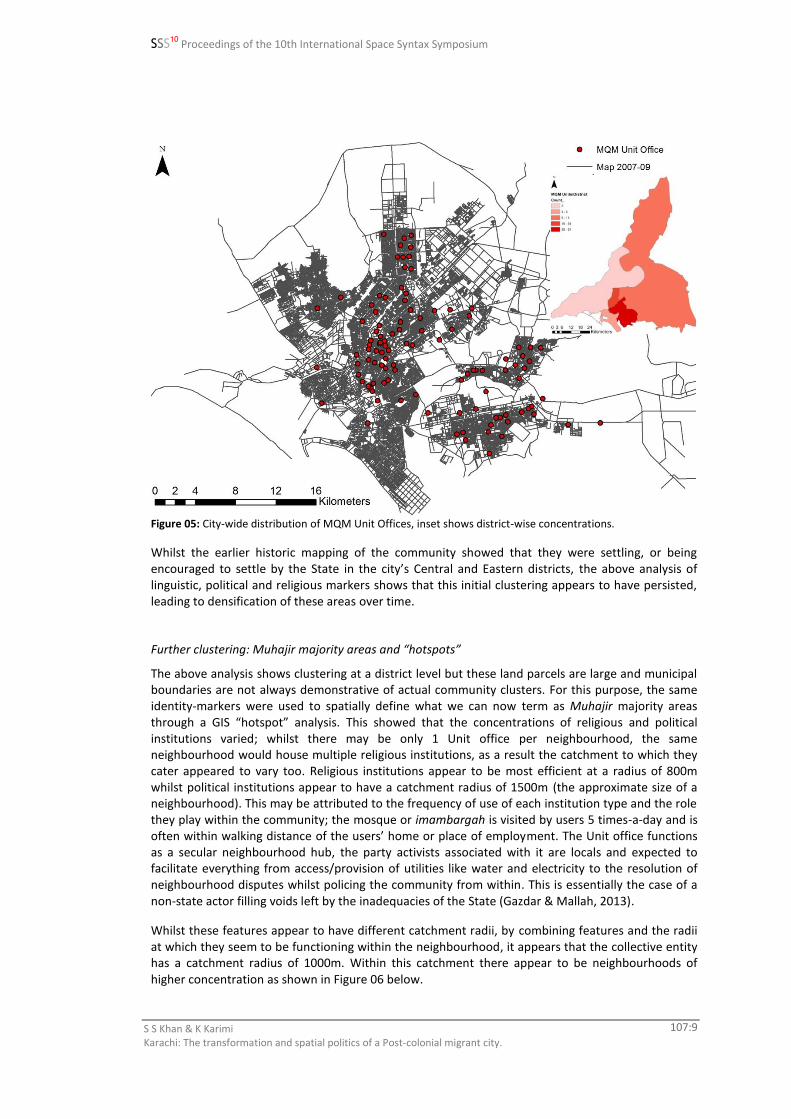
The MQM has a three tier party structure; Nine Zero the nation-wide HQ of the organisation located in Azizabad, a middle-income neighbourhood in Karachi’s District Central, under which there are 26 city-wide sector offices, each overseeing 8-10 unit offices embedded within the neighbourhood they serve. Again like language and religion, clusters of unit offices show that the highest concentrations of MQM units can be found in districts Central and East (Figure 05).
SSS10 Proceedings of the 10th International Space Syntax Symposium
S S Khan & K Karimi Karachi: The transformation and spatial politics of a Post-colonial migrant city.
107:9
Figure 05: City-wide distribution of MQM Unit Offices, inset shows district-wise concentrations.
Whilst the earlier historic mapping of the community showed that they were settling, or being encouraged to settle by the State in the city’s Central and Eastern districts, the above analysis of linguistic, political and religious markers shows that this initial clustering appears to have persisted, leading to densification of these areas over time.
Further clustering: Muhajir majority areas and “hotspots”
The above analysis shows clustering at a district level but these land parcels are large and municipal boundaries are not always demonstrative of actual community clusters. For this purpose, the same identity-markers were used to spatially define what we can now term as Muhajir majority areas through a GIS “hotspot” analysis. This showed that the concentrations of religious and political institutions varied; whilst there may be only 1 Unit office per neighbourhood, the same neighbourhood would house multiple religious institutions, as a result the catchment to which they cater appeared to vary too. Religious institutions appear to be most efficient at a radius of 800m whilst political institutions appear to have a catchment radius of 1500m (the approximate size of a neighbourhood). This may be attributed to the frequency of use of each institution type and the role they play within the community; the mosque or imambargah is visited by users 5 times-a-day and is often within walking distance of the users’ home or place of employment. The Unit office functions as a secular neighbourhood hub, the party activists associated with it are locals and expected to facilitate everything from access/provision of utilities like water and electricity to the resolution of neighbourhood disputes whilst policing the community from within. This is essentially the case of a non-state actor filling voids left by the inadequacies of the State (Gazdar & Mallah, 2013).
Whilst these features appear to have different catchment radii, by combining features and the radii at which they seem to be functioning within the neighbourhood, it appears that the collective entity has a catchment radius of 1000m. Within this catchment there appear to be neighbourhoods of higher concentration as shown in Figure 06 below.

SSS10 Proceedings of the 10th International Space Syntax Symposium
S S Khan & K Karimi Karachi: The transformation and spatial politics of a Post-colonial migrant city.
107:10
Figure 06: Muhajir neighbourhoods exhibiting higher concentrations of Muhajir identity-markers.
Keeping in mind the political nature of this community, in the past many of the 12 hotspots identified have been designated as “no-go areas” by the city’s security forces due to numerous clashes between the MQM and security forces. These include the areas of Liaquatabad, Golimar and Lines Area in particular. Additionally, this synthesis of features brings to light that there is a noticeable absence of a Muhajir presence in the city’s elite district to the south and the ethnically mixed informal settlements to the west.
5. The political outcomes of spatial clustering.
In 2002, a new devolution plan was put in place, replacing Karachi’s previous five district form of governance with 18 towns and 178 union councils, with each union council having 13 elected councillors. During this time MQM had the highest number of elected councillors of any political party in the City District Government, this form of governance giving them more access to both political power and funds than they had experienced since 1992 when, during an army led operation, many of MQM’s top leadership was forced underground or into exile. This resulted in a mushrooming of infrastructure development projects across the city. This section will show how the structure of the city has changed with this shift in the power politics of the city, in many cases to the advantage of the Muhajir community. This is not to say that all changes to the structure of the city can be attributed to the change in the accessibility to power of the Muhajir community.
Location of the integration core
As the city has grown as a response to its changing economic role and successive waves of in-migration, both commercial and residential trends have changed too. The traditional market spaces of the old city centre now exist in declining simultaneity with indoor “shopping centres” and malls, resulting in the emergence of newer commercial districts outside of the old city centre serving large populations settled further afield. Simultaneously, the shift away from the joint family to a nuclear

SSS10 Proceedings of the 10th International Space Syntax Symposium
S S Khan & K Karimi Karachi: The transformation and spatial politics of a Post-colonial migrant city.
107:11
family structure has led to the rapid development of multi-storey apartment complexes at the periphery of the city and the movement out of the congested city centre of a populace that has been resident there since Partition. This has been a slow process, happening as and when their financial conditions have allowed. Collectively these phenomena may be partially responsible for the decline of the old city where today the downtown areas comprise of wholesale markets and warehousing.
This shift of primary retail activity away from the old city centre seems to be mirrored by the movement of the integration core away from the old city centre towards the north of the city closer to the city’s geographic and population centres, illustrated in Figure 07 below.
Figure 07. Clockwise from top left, the old city centre 1949, 1958-60, 1972-74, and 2007-09. The images show the shifting of the integration core to incorporate early Muhajir settlements to the north of the old city centre.
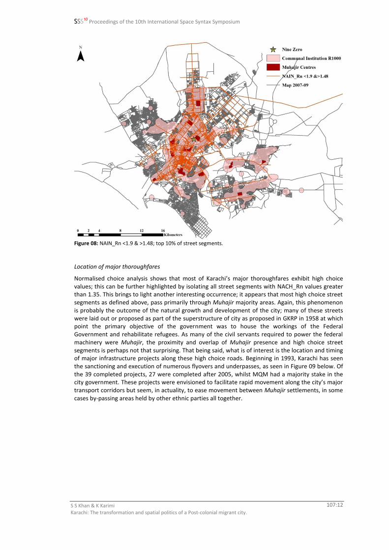
Whilst this shift has taken place over the course of the city’s modern history, what is of particular interest is that the integration core has shifted further into the body of the Muhajir centre of the city as defined by the hotspot analysis earlier. This is further illustrated in Figure 08, showing that the top 10% of globally integrated street segments are found within the catchment of the Muhajir majority areas.
SSS10 Proceedings of the 10th International Space Syntax Symposium
S S Khan & K Karimi Karachi: The transformation and spatial politics of a Post-colonial migrant city.
107:12
Figure 08: NAIN_Rn <1.9 & >1.48; top 10% of street segments.
Location of major thoroughfares
Normalised choice analysis shows that most of Karachi’s major thoroughfares exhibit high choice values; this can be further highlighted by isolating all street segments with NACH_Rn values greater than 1.35. This brings to light another interesting occurrence; it appears that most high choice street segments as defined above, pass primarily through Muhajir majority areas. Again, this phenomenon is probably the outcome of the natural growth and development of the city; many of these streets were laid out or proposed as part of the superstructure of city as proposed in GKRP in 1958 at which point the primary objective of the government was to house the workings of the Federal Government and rehabilitate refugees. As many of the civil servants required to power the federal machinery were Muhajir, the proximity and overlap of Muhajir presence and high choice street segments is perhaps not that surprising. That being said, what is of interest is the location and timing of major infrastructure projects along these high choice roads. Beginning in 1993, Karachi has seen the sanctioning and execution of numerous flyovers and underpasses, as seen in Figure 09 below. Of the 39 completed projects, 27 were completed after 2005, whilst MQM had a majority stake in the city government. These projects were envisioned to facilitate rapid movement along the city’s major transport corridors but seem, in actuality, to ease movement between Muhajir settlements, in some cases by-passing areas held by other ethnic parties all together.

SSS10 Proceedings of the 10th International Space Syntax Symposium
S S Khan & K Karimi Karachi: The transformation and spatial politics of a Post-colonial migrant city.
107:13
Figure 09: Street segments with a normalised choice value greater than 1.35 at Rn, Muhajir centres and flyovers overlaid on Muhajir clusters at R1000m.
Location of major commercial centres
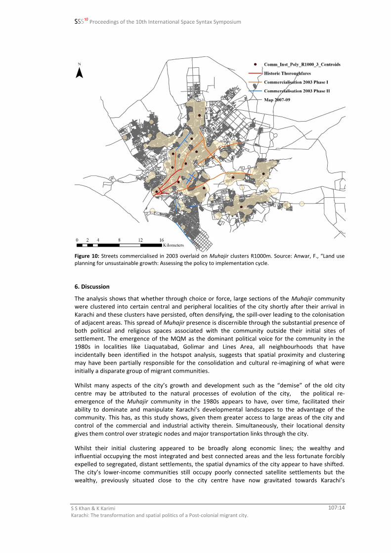
Whilst both initial Muhajir settlements as well as all commercial activity was confined to the old city centre, over time, as the city has grown and population densities have shifted, newer commercial areas have emerged outside the city centre to cater to these shifts. Unlike the commercial areas of the old city centre, many of the newer areas started as informal commercial areas but, through a long process that culminated in 2003 whilst MQM’s Syed Mustafa Kamal was the city’s Nazim or mayor, 17 streets city-wide were officially categorised as commercial; 6 major roads in phase 1 followed by 11 more in phase 2. Again as was the case with the major thoroughfares of the city, many of these streets are high choice street segments or part of the integration core of the city. So whilst the logic of the location of these commercial areas seems obvious, the political advantage of the situation too seems undeniable; of the 17 streets that were commercialised, only 2 are to be found outside the Muhajir majority areas. These outliers are both situated in the city’s elite localities of Defence and Clifton, whilst there is a noticeable absence of official commercialisation in the city’s lower-income localities of Landhi and Korangi to the east and Orangi Town and Baldia to the west (Figure 10).
SSS10 Proceedings of the 10th International Space Syntax Symposium
S S Khan & K Karimi Karachi: The transformation and spatial politics of a Post-colonial migrant city.
107:14
Figure 10: Streets commercialised in 2003 overlaid on Muhajir clusters R1000m. Source: Anwar, F., “Land use planning for unsustainable growth: Assessing the policy to implementation cycle.
6. Discussion
The analysis shows that whether through choice or force, large sections of the Muhajir community were clustered into certain central and peripheral localities of the city shortly after their arrival in Karachi and these clusters have persisted, often densifying, the spill-over leading to the colonisation of adjacent areas. This spread of Muhajir presence is discernible through the substantial presence of both political and religious spaces associated with the community outside their initial sites of settlement. The emergence of the MQM as the dominant political voice for the community in the 1980s in localities like Liaquatabad, Golimar and Lines Area, all neighbourhoods that have incidentally been identified in the hotspot analysis, suggests that spatial proximity and clustering may have been partially responsible for the consolidation and cultural re-imagining of what were initially a disparate group of migrant communities.
Whilst many aspects of the city’s growth and development such as the “demise” of the old city centre may be attributed to the natural processes of evolution of the city, the political re-emergence of the Muhajir community in the 1980s appears to have, over time, facilitated their ability to dominate and manipulate Karachi’s developmental landscapes to the advantage of the community. This has, as this study shows, given them greater access to large areas of the city and control of the commercial and industrial activity therein. Simultaneously, their locational density gives them control over strategic nodes and major transportation links through the city.
Whilst their initial clustering appeared to be broadly along economic lines; the wealthy and influential occupying the most integrated and best connected areas and the less fortunate forcibly expelled to segregated, distant settlements, the spatial dynamics of the city appear to have shifted. The city’s lower-income communities still occupy poorly connected satellite settlements but the wealthy, previously situated close to the city centre have now gravitated towards Karachi’s

SSS10 Proceedings of the 10th International Space Syntax Symposium
S S Khan & K Karimi Karachi: The transformation and spatial politics of a Post-colonial migrant city.
107:15
segregated elite beachfront satellite to the south. This shift has resulted in the central areas of the city being dominated by a politically active middle-income group.
Thus analysis shows that a “Muhajir city” composed of multiple clusters does exist and that it is well serviced, well connected and strategically located to the advantage of the community but, it is confined primarily to the central areas of the city. These clusters have an identifiable spatial dynamic tied to the community’s economic and political profile that can be explored through further analysis of the individual settlements identified earlier. This Muhajir heartland is flanked by a highly segregated, ethnically mixed, dense slum city to the west, an equally segregated elitist enclave to the south, and a lower-middle income Muhajir satellite that despite efforts to integrate it into the city’s central stronghold, still functions spatially as a segregated satellite. This gives the impression that there are potentially multiple centres or enclaves operating in simultaneity, catering to the different income and ethnic groups of the city, with perhaps only the central one being supported by the “state” in the provision of services and utilities as the “state” currently happens to be the political representatives of the Muhajir community.
7. Conclusion
What this study has shown is that Karachi, a city that has been labelled an ‘instant city’ (Inskeep, 2011), is a city that has grown exponentially both in terms of area and population in a very short period of time. This growth has resulted in the coming together of a multiplicity of communities all vying for the same resources. And, through a process of State sponsored maginalisation of one group and patronage of another, communities, utilising their spatial clustering and proximities to their advantage, have had to organise themselves along ethno-political lines in order to demand and protect their cultural, economic and political interests, staking claims on land, votes and power where they can. The Muhajir community in particular, despite their minority status within Pakistan, have used their state imposed clustering and numeric superiority in Karachi to their political advantage. They have managed, it appears, through both force and political process, to restructure the city’s planning and development, to a degree, to their benefit giving them greater control of transport links and the city’s commercial activity.
What this study in part seems to suggest is that whilst sectarian divides appear to be growing, being exploited by extremist elements in Pakistan today as is often highlighted by the media, socio-spatial divisions in large urban areas like Karachi appear to be governed primarily by ethnic and economic factors with communities loosely establishing ethnic or economic enclaves in the city.
Whilst this kind of socio-spatial research shows the socio-political strength of one community and its ability to adapt its spaces, it simultaneously brings to light the disproportionate distribution of some of the city’s services and resources. It also highlights the spatial peripheralization and limited infrastructure development that numerically smaller, and/or economically and therefore politically weaker communities’ experience in the city. This disproportionate distribution and limited access to the benefits of urban living is possibly the root of Karachi’s volatility, initially experienced by the Muhajir community only to be perpetuated by them today.
References
Ansari, S. (2005), Life After Partition: Migration, Community and Strife in Sindh 1947-1962. Karachi: Oxford University Press.
Anwar, F., “Land use planning for unsustainable growth: Assessing the policy to implementation cycle. Commercialisation of roads in Karachi: A case study.”
Charalambous, N., and Hadjichristos, C.(2011), “Overcoming Division in Nicosia’s Public Space.”. In Built Environment 37 (2), p. 170-182.
Ferati, A. (2009). “Spatial Ethnic Patterns: The interface between ‘majority’ and ‘minority’ in Macedonia.” In: Koch, D., Marcus, L. and Steen, J. (eds.) Proceedings, Seventh International Space Syntax Symposium, Stockholm: Royal Institute of Technology, 030, p.1-6
Gazdar, H., H.B. Mallah., 2013. “Informality and Political Violence in Karachi.”. In Urban Studies. Special Issue Article: Cities, Conflict and State Fragility in the Developing World, Vol. 50 (15), p. 3099-3115.

SSS10 Proceedings of the 10th International Space Syntax Symposium
S S Khan & K Karimi Karachi: The transformation and spatial politics of a Post-colonial migrant city.
107:16
Gayer, L. 2014. Karachi: Ordered Disorder and the Struggle for the City. London: Hurst & Company. Hasan, A. 1999. Understanding Karachi: Planning and reform for the future. Karachi: City Press. Hasan, A., 2005. “The Political and Institutional Blockages to Good Governance: The Case of the Lyari
Expressway in Karachi.”. In Environment and Urbanization, Vol. 17(2), p. 127-141. Inskeep, S., 2011. Instant City: Life and death in Karachi. Penguin Books. Jones, J., 2007. The Shi’a Muslims of the United Provinces of India, c.1890-1940. Pembroke College, University of
Cambridge PhD Karimi, K., Amir, A., Shafiei, K., Raford, N., Abdul, E., Zhang, Ji., Mavridou, M. (2007), Evidence-Based Spatial
Intervention for Regeneration of Informal Settlements: the case of Jeddah central unplanned areas. In: Kubat, A.S., Ertekin, O., Guney, Y.I. and Eyubolu, E. (eds.), Proceedings, Sixth International Space Syntax Symposium, Istanbul: ITU Faculty of Architecture, 034, p.1-14
Legeby, A., 2009. ‘Accessibilty and Urban Life: Aspects on Social Segregation.’, In: Koch, D., Marcus, L. and Steen, J. (eds.) Proceedings, Seventh International Space Syntax Symposium, Stockholm: Royal Institute of Technology, 064, p.1-11
Mahmood, S., 1999. “Shelter Within my Reach”: Medium Rise Apartment Housing for the Middle Income Group in Karachi, Pakistan. Masters Dissertation, MIT.
Peach, C., 1996. “Good segregation, bad segregation.”. In Planning perspectives 11, no. 4, pp. 379–398. Phillips, D., 2006. “Parallel Lives? Challenging discourses of British Muslim self-segregation”. In Environment and
Planning D: Society and Space. 24 (1), pp. 25-40. Rahman, T., 2011. From Hindi to Urdu: A Social and Political History. Karachi: Oxford University Press. Raman, S. (2003). Communities and the Spatial Culture in a Communally Diverse City: Ahmedabad, India. In:
Hanson, J. (ed.), Proceedings of the Fourth International Space Syntax Symposium, London: University College London, 074, p.1-18.
Robinson, F. (2014), “Introduction: The Shi’a in South Asia.”. In Journal of the Royal Asiatic Society, Vol. 24 (3), pp. 353-361.
Sennett, R. (1996), Flesh and stone: the body and the city in Western civilization. London: Faber and Faber Limited.
Sibley, D. (1995), Geographies of Exclusion. London: Routledge. Siddiqi, A.R. (2008), Partition and the Making of the Mohajir Mindset: A Narrative. Karachi: Oxford University
Press. Vaughan, L., Chatford Clark, D.L., Sahbaz, O., Haklay, M. (2005). “Space and Exclusion: does urban morphology
play a part in social deprivation?” Royal Geographical Society. Vaughan, L. Arbaci, S. (2011). “The Challenges of Understanding Urban Segregation”. In Built Environment, Vol
37, No.2 Verkaaik, O. (2004), Migrants and Militants: Fun and Urban Violence in Pakistan. Princeton University Press. Werbner, P. (2005), “The translocation of culture: ‘community cohesion’ and the force of multiculturalism in
history.” In The Sociological Review. Vol. 53, Issue 4, pp. 745-768. Zako, R. (2009), ‘Young Peoples’s Gatherings in the Urban Public Realm: enhancement of or distraction from its
liveability.’ In: Koch, D., Marcus, L. and Steen, J. (eds.) Proceedings, Seventh International Space Syntax Symposium, Stockholm: Royal Institute of Technology, 066, p. 1-16.
Software
Varoudis T., 2012, 'depthmapX Multi-Platform Spatial Network Analysis Software’, Version 0.30 OpenSource, http://varoudis.github.io/depthmapX/