karma village profile - applied research...
TRANSCRIPT

Karma Village Profile
Prepared by
The Applied Research Institute - Jerusalem
Funded by
Spanish Cooperation Azahar program
2009

Palestinian Localities Study Hebron Governorate
1
Acknowledgments ARIJ hereby expresses its deep gratitude to the Spanish Agency for International Cooperation for Development (AECID) for their funding of this project through the Azahar Program. ARIJ is grateful to the Palestinian officials in the ministries, municipalities, joint services councils, village committees and councils, and the Palestinian Central Bureau of Statistics (PCBS) for their assistance and cooperation with the project team members during the data collection process.
ARIJ also thanks all the staff who worked throughout the past couple of years towards the accomplishment of this work.

Palestinian Localities Study Hebron Governorate
2
Background
This booklet is part of a series of booklets, which contain compiled information about each city, town, and village in Hebron Governorate. These booklets come as a result of a comprehensive study of all localities in Hebron Governorate, which aims at depicting the overall living conditions in the governorate and presenting developmental plans to assist in developing the livelihood of the population in the area. It was accomplished through the 'Village Profiles and Azahar Needs Assessment'; a project funded by the Spanish Agency for International Cooperation for Development (AECID) and the Azahar Program. The 'Village Profiles and Azahar Needs Assessment' was designed to study, investigate, analyze and document the socio-economic conditions and the needed programs and activities to mitigate the impact of the current unsecure political, economic and social conditions in Hebron Governorate with particular focus on the Azahar program objectives and activities concerning water, environment, and agriculture. The project's objectives are to survey, analyze and document the available natural, human, socioeconomic and environmental resources, and the existing limitations and needs assessment for the development of the rural and marginalized areas in Hebron Governorate. In addition, the project aims at preparing strategic developmental programs and activities to mitigate the impact of the current political, social, and economic instability with the focus on the agricultural sector. All locality profiles in Arabic and English are available online at http://proxy.arij.org/vprofile/
Palestinian Localities Study Hebron Governorate
3
Table of Contents
Location and Physical Characteristics _____________________________________________4
History_______________________________________________________________________5
Religious and Archeological Sites _________________________________________________5
Population____________________________________________________________________6
Education ____________________________________________________________________7
Health Status _________________________________________________________________8
Economic Activities ____________________________________________________________8
Agricultural Sector_____________________________________________________________9
Institutions and Services _______________________________________________________12
Infrastructure and Natural Resources ____________________________________________12
Impact of Israeli Occupation ____________________________________________________12
Development Plans and Projects _________________________________________________13
Locality Development Priorities and Needs ________________________________________14
References___________________________________________________________________15

Palestinian Localities Study Hebron Governorate
4
Karma Village Profile
Location and Physical Characteristics Karma is a Palestinian village in the Dura area located 11 km southwest of Hebron city, in southern West Bank. The village is located south of the Governorate of Hebron. It is bordered by Beit 'Amra village (Yatta) to the east, Deir Razih village to the north, Rabud village to the south, and Imreish village to the west.
Map 1: Karma village location and borders
Karma village is located on mountains area south of Dura city, at the moderate elevation of 694m above sea level. The mean annual rainfall in Karma village is 436 mm; the average annual temperature is 16 °C, and the average annual humidity is 61 % (ARIJ GIS).

Palestinian Localities Study Hebron Governorate
5
Karma village has been governed by a village council since 1998, which today comprises of 7 elected members with two full time employees. The village council operations and responsibilities include:
1. Administration, planning and development; 2. Social development services; 3. Infrastructure maintenance, water, electricity, solid waste collection, and the distribution
of social services.
History The history of Karma dates back to the time of Turkish times and British mandate. According to one narrative – Karma’s name is derived from the Al Shekh "Kar'am" Convent in the village. Over time the name slowly converted to "Karma". Other narrative mentioned that the name of Karma is derived from its famous vineyards, almond and olive trees which means in Arabic "karm". The origin of Karma village residents came from Dura city, from Al Awawda family.
Photos of Karma
Religious and Archeological Sites There are two Mosques in Karma village: Karma Old Mosque and Al Sadeaq New Mosque. The village has no archeological sites.
Palestinian Localities Study Hebron Governorate
6
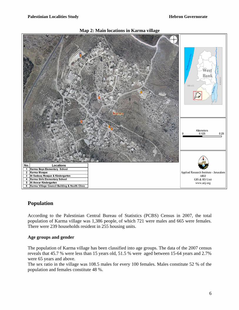
Map 2: Main locations in Karma village
Population According to the Palestinian Central Bureau of Statistics (PCBS) Census in 2007, the total population of Karma village was 1,386 people, of which 721 were males and 665 were females. There were 239 households resident in 255 housing units. Age groups and gender The population of Karma village has been classified into age groups. The data of the 2007 census reveals that 45.7 % were less than 15 years old, 51.5 % were aged between 15-64 years and 2.7% were 65 years and above. The sex ratio in the village was 108.5 males for every 100 females. Males constitute 52 % of the population and females constitute 48 %.

Palestinian Localities Study Hebron Governorate
7
Families The population of Karma is comprised of three families: Awawdeh, Abu Arkoub and Haja family.
Education The 2007 census showed that in Karma village about 12.8% of the residents were illiterate. Women (68.3%) comprised a greater percentage of illiterates than men (31.7 %). Of the literate population, 16.2% of residents could read and write, 24.3% completed their elementary education, 29% completed their preparatory education and 17.7% completed their secondary and higher education. Table 1 shows the education status in Karma by sex and education attainment in 2007.
Table 1: Karma population (10 years and above) by sex and educational attainment Sex
Illiterate Can read & write Elementary Preparatory Secondary Associate
Diploma Bachelor Higher Diploma Master PhD Total
M 24 64 115 113 101 17 32 - 3 1 470 F 47 49 107 122 83 12 23 1 2 - 446 T 71 113 222 235 184 29 55 1 5 1 916
Source: PCBS, March 2009. Population, Housing and Establishment Census-2007, Final Results According to the field survey there are two schools in Karma village; one is co-education and the second for is only for girls. The two schools are supervised by government sector.
School Name Type by Sex Supervising Authority 1. Karma Elementary Co-education School Co-education Governmental 2. Karma Girls Elementary School Female Governmental
According to Ministry of Higher Education (MOHE) data, by the end of the 2006/2007 scholastic year there were 354 students (194 males and 160 females), 22 teachers (13 males and 9 females), and 16 classes of which 8 were co-educational.
Table 2: Total No., classes and students by sex in Karma village (2006-2007) Government Private Total
No. of Schools 1 1 No. of class 4 4 No. of Teachers 6 6
Female
No. of Students 60 60 No. of Schools 1 1 No. of class 12 12 No. of Teachers 16 16
Co-education
No. of Students 294 294 Source: MEHE- Hebron Directorate -2006/2007

Palestinian Localities Study Hebron Governorate
8
In 2007, a survey discovered that there were two kindergartens in Karma village, the Karma Kindergarten and Al Anwar Kindergarten. Both provide pre-school education services to about 130 children and are supervised by the private sector. Karma lacks secondary stages in its schools. Most of its students attend Dura Secondary Schools to complete their school education. This however is about 11 km away. The educational sector in the village suffers from the following problems:
• The distance of Dura schools for the secondary students. • Lack of regular transportation • Restriction of Israeli checkpoints on the roads.
Health Status Karma village lack any kind of major health institution. The village only has a simple health clinic and one maternity and a pediatric center. In general there are no health services or private physician clinics, pharmacy, ambulances or medical laboratory. In emergency cases, residents of Karma have to receive their health services from neighboring localities or Hebron city (which is around 17 km away) and Yatta city (8 km away). The health sector in Karma suffers from the lack of a full time physician in the village, a lack of a complete health center to provide general services to the village, and also the distance from other services.
Economic Activities The economy of Karma is characterized by its complex diversity. The main portion of the population is dependent on agriculture and trade sectors, where about 30% and 20% are engaged in the two sectors respectively. 15% of the work force work in the Israeli labor market and 15% are employed in public and private sectors. Finally 20% (10% for each) are employed in the industrial and services sectors. In the terms of local economic institutions; there are two groceries, 11 clothes shops, one butchers and one blacksmith. Based on a survey conducted in November 2007 by ARIJ in Hebron Governorate localities, the social groups most affected in the village by the Israeli restrictions during the second Intifada were: 1) previous worker in Israeli labor market, 2) families maintaining 6 individuals and more, 3) small-scale farmers, 4) small-scale traders and 5) housewives and children. Labor Force The 2007 census revealed that in Karma about 67.8 % of the population was within the working age group 10 years and above. Out of 916 people of the working age, 270 people (29.5 %) were economically active –in the labor force- and 646 people (70.5 %) were not economically active. Of the economically active people 88 % were males and 12 % were females. 83 % of Karmas residents were employed. The largest groups of non-economically active people are

Palestinian Localities Study Hebron Governorate
9
housekeeping and students, who constitute 52.2 % and 36.7 % respectively. Table 3 shows the labor force status in Karma village.
Table 3: Karma population (10 years and above) by sex and employment status Sex
Economically Active Not Economically Active
Employed Currently Unemployed
Unemployed (Never Worked)
Total Students House keeping
Unable to work
Not working & Not looking For Work
Other Total Total
M 196 12 29 237 182 - 42 3 6 233 470 F 28 - 5 33 155 237 21 - - 413 446 T 224 12 34 270 337 237 63 3 6 646 916
Source: PCBS, March 2009. Population, Housing and Establishment Census-2007, results The survey also indicated that the share of the population working in the various sectors of the economy is listed below by percentage:
• The agriculture sector 30 %, • The service sector 25 %, • Israeli labor market 15%. • The industrial sector 10 %, • The trade sector 20 %,
Figure 1: Percentage of economic activity in Karma village
Service sector , 25%
Israeli labor market sector,
15%
Industrialsector , 10%
Trade sector, 20% Agriculture sector
, 30%
Agricultural Sector Karma village lies on a total area of 2,000 dunums. 1,640 dunums are considered arable land; however, only 1,260 dunums are currently cultivated.

Palestinian Localities Study Hebron Governorate
10
Table 4: Land Use in Karma Village (dunum) Arable Land Total
Area Cultivated Area
Uncultivated Area
Built up Area
Forests Area
Open Spaces and Rangelands
2,000 1,260 380 160 4 66 Source: Palestinian Ministry of Agricultural (MOA), 2006
Map 3: Land use/ Land cover and Segregation wall route in Karma village
Table 5 shows the different types of rain-fed and irrigated open cultivated vegetables in the village of Karma. The rain-fed fruity vegetables are the most cultivated with an area of about 30.5 dunums. The most common vegetables cultivated within this area are zucchini, squash and snack cucumber (Faqous). Table 5: Rain Fed and irrigated open cultivated vegetables in Karma Village (dunum) Total fruity vegetables
Total leafy vegetable
Total green legumes
Total bulbs
Total other vegetables
Total rain fed and irrigated open vegetables
RF Irr. RF Irr RF Irr. RF Irr. RF Irr. RF Irr. 30.5 0 0 0.5 2 0 0 0 3 0 35.5 0.5
RF: Rain-fed, Irr: Irrigated

Palestinian Localities Study Hebron Governorate
11
There are 2 types of aromatic medical plants in the village of Karma totaling an area of about 2 dunums. These plants are thyme and sage. In the village of Karma, there is a total area of 452 dunums of olive trees plantations. Other trees planted in the area are mostly almond trees, apricot trees, cherry trees, fig trees and grape vines.
Table 6: Total area of horticulture and olive tree in Karma Village (dunum) Total area of olives
Total area of citrus
Total area of stone-fruits
Total area of pome fruits
Total area of nuts
Total area of the other fruit
Total area of horticulture and olive tree
RF Irr. RF Irr. RF Irr. RF Irr. RF Irr. RF Irr. RF Irr. 452 0 0 3 66 0 1 0 329 0 88 0 936 3
RF: Rain-fed, Irr: Irrigated Table 7 shows the total field crops cultivated in the village of Karma. Cereals, in particular wheat and barley, are the most cultivated crops with an area of about 110 dunums. In addition, the cultivation of dry legumes crops, mostly lent, and forage crops such as bitter and common vetch and lentils is prevalent in the village of Karma.
Table 7: Total Field crops in Karma Village (dunum) Total Cereals
Total bulbs
Dry legumes
Oil crops
Total seeds
Total forage crops
Total stimulatingcrops
Total other crops
Total Field crops
RF Irr RF Irr RF Irr RF Irr RF Irr RF Irr RF Irr RF Irr RF Irr
110 0 4 0 34 0 0 0 0 0 130 0 3 0 2 0 283 0
RF: Rain-fed, Irr: Irrigated The data also indicates that the residents of Karma village are also dependent upon rearing livestock. About 7 % of the residents breed animals such as sheep and goats.
Table 8: Live Stock in Karma Village Cows* Sheep Goats Camels Horses Donkeys Mules Broilers Layers Bee Hives
2 740 170 0 0 17 1 0 0 0 *Including cows, bull calves, heifer calves and bulls Karma is an Agricultural village, and as mentioned above it has a small area most of which is arable land. 1,640 dunums are arable land and currently approximately 30 % of the residents are engaged in agriculture activities. Karma is famous for its vineyards and fruit trees. Rainfall is the main source of water for irrigation in the village, but the field survey data indicated that the farmers also depend on cisterns to irrigate their crops. Though there are about 3 km of agricultural roads in Karma that are suitable for driving tractors and other agricultural machines, they are insufficient for the village needs. The village is in need of new roads to cover the vast agricultural area in the village.
Palestinian Localities Study Hebron Governorate
12
Institutions and Services Karma is a small rural village; the residents get their most services from the cities of Dura and Hebron. However, there is a village council that was established in 1998, consisting of seven members. There are no other institutions in the village.
Infrastructure and Natural Resources • Telecommunication Services: Karma village is currently connected to a telecommunication
network. Approximately 77% of the households have a telephone connection. • Water Services: Karma is not connected with a water network. Rain water collection cisterns
and water tanks are the main source of water for the residents. The residents face many problems in regards to supply, including the high prices of water tanks, and the inability of residents to buy the water due to the deterioration of economic situation.
• Electricity Services: Karma has been connected to electricity network since 1997.
Approximately 100% of households in the village are connected to the electricity network. Karma village council manages the distribution of electricity which is supplied by Israeli Electric Cooperation.
• Solid Waste Collection Services: There is no solid waste management system in the village,
residents dispose of the generated solid waste on random burning sites. The village suffers from environment problems due to the widely scattered household wastes and the smoke generated from burning them.
• Sewage Disposal Facilities: There is no sewage network in the village. All housing units in
Karma rely solely on cesspits. • Transportation Services: There are about 5.5 km of internal roads in Karma village. 2 km
are paved and in a good condition, 1 km are paved but in a poor condition and 2.5 km are not paved at all. The only means of transportation in Karma comprises of three informal taxis. There are many obstacles in the transportation sector for the village, these include:
1. Israeli check points and barriers. 2. Deterioration of the roads. 3. Shortage of vehicles and transportation services
Impact of Israeli Occupation Due to its location on the bypass road and near Israeli settlements, Karma is subject to many Israeli actions. 1,480 dunums had been confiscated from the village land for the construction of settlements and bypass roads. One settlement has been built on the village land, (Otniel). There is

Palestinian Localities Study Hebron Governorate
13
also a military base to the south east. Since the beginning of the second Intifada in 2000, the Israeli forces have confiscated a further 120 dunums, destroyed more than 1,250 dunums. They have also uprooted 300 vineyards tree, 90 stone fruits tree and 111 forest trees. On the east entry of Karma, Israel forces have built a permanent military checkpoint with Iron Gate which restricts local movement from entering or leaving the village. Karma has also been affected by flying checkpoints which restrict the movement towards Dura and Adh Dhahiriya. These checkpoints restrict, access to health services in other localities, and make it difficult for physicians to reach clinics and health centers in the village. Teachers and students also find it difficult to access schools and universities, and farmers to access their lands.
Development Plans and Projects Karma village council has established a development plan which includes development projects. Since 2004 the village council has implemented many projects funded by outside donors, these projects includes:
Table 9: Development plans and projects in Karma village No. Project name Type Funded by 1 Paving the entrance of the village Infrastructure PECADER 2 Building and finishing new four rooms
in the school Educational PECADER
3 Building a wall for the school and paved field yard of the school.
Educational Save Children
4 Paving the entrance of the village with Yatta city
Infrastructure PECADER

Palestinian Localities Study Hebron Governorate
14
Locality Development Priorities and Needs According to Karma village council the village has suffering from a shortage of many infrastructural and services needs. Table 10 shows the development priorities in the village.
Table 10: Development Priorities and Needs in Karma No. Sector Strongly
Needed Needed Moderately
Needed Not
Needed Notes
Infrastructural Needs
1 Opening and Pavement of Roads * 7 km 2 Construction of New Water Networks * 4 km 3 Rehabilitation of Old Water Networks * 4 Construction of Water Reservoirs * 3,000 m³ 5 Extending the Water Network to cover New
Built up Areas * 1 km
6 Construction of Sewage Disposal Network * Health Needs
1 Building of New Clinics or Health Care Centre
*
2 Rehabilitation of Old Clinics or Health Care Centres
*
3 Purchasing of Medical Equipments and Tools
*
Educational Needs 1 Building of New Schools * 2 Rehabilitation of Old Schools * 3 Purchasing of New Equipments for Schools * Agriculture Needs 1 Rehabilitation of Agricultural lands * 600 dunum 2 Building Cisterns * 2 Cisterns 3 Construction of Barracks for Livestock * 5 4 Veterinary Services * 5 Seeds and Hay for Animals * 6 Rehabilitation of Greenhouses * 3 Greenhouses 7 Field Crops Seeds * 8 Plants and Agricultural Supplies *

Palestinian Localities Study Hebron Governorate
15
References:
- Applied Research Institute – Jerusalem (ARIJ). GIS Database. 2006-2009. - Ministry of Agriculture. Agricultural Status Database in Hebron Governorate. 2006.
- Ministry of Higher Education. Educational Status Database. 2006-2007.
- Palestinian Central Bureau of Statistics. Population, Housing and Establishment
Census- Final Results. Ramallah, Palestine. 1997 -2007.