keadby wind farm extension - national … · 2016-06-28 · 1.1 background information 1 1.2...
TRANSCRIPT

Keadby Wind Farm Extension
Environmental Impact Assessment Scoping Report
February 2015

THIS PAGE IS INTENTIONALLY BLANK

Document control sheet BPP 04 F8
Project: Keadby Wind Farm Extension Client: SSE Renewables Project No: B1486010 Document title: Environmental Impact Assessment Scoping Report
Originated by Checked by Reviewed by
VERSION NAME NAME NAME
V3.0 Eleanor King Kay Griffin Jo Moran
Approved by NAME As Project Manager I confirm that the above
document(s) have been subjected to Jacobs’ Check and Review procedure and that I approve them for issue
INITIALS
JM
DATE 30.05.14 Document status – Final Report issued to client.
REVISION NAME NAME NAME
V4.0 David Heelan Jo Moran Jo Moran
Approved by NAME As Project Manager I confirm that the above
document(s) have been subjected to Jacobs’ Check and Review procedure and that I approve them for issue
INITIALS
Jo Moran JM
DATE 29.01.15 Document status – Draft Report
REVISION NAME NAME NAME
V7.0 David Heelan Lynne Eastham Jo Moran
Approved by NAME As Project Manager I confirm that the above
document(s) have been subjected to Jacobs’ Check and Review procedure and that I approve them for issue
INITIALS
Jo Moran JM
DATE 23.02.15 Document status – Final Report
Jacobs U.K. Limited This document has been prepared by a division, subsidiary or affiliate of Jacobs U.K. Limited (“Jacobs”) in its professional capacity as consultants in accordance with the terms and conditions of Jacobs’ contract with the commissioning party (the “Client”). Regard should be had to those terms and conditions when considering and/or placing any reliance on this document. No part of this document may be copied or reproduced by any means without prior written permission from Jacobs. If you have received this document in error, please destroy all copies in your possession or control and notify Jacobs. Any advice, opinions, or recommendations within this document (a) should be read and relied upon only in the context of the document as a whole; (b) do not, in any way, purport to include any manner of legal advice or opinion; (c) are based upon the information made available to Jacobs at the date of this document and on current UK standards, codes, technology and construction practices as at the date of this document. It should be noted and it is expressly stated that no independent verification of any of the documents or information supplied to Jacobs has been made. No liability is accepted by Jacobs for any use of this document, other than for the purposes for which it was originally prepared and provided. Following final delivery of this document to the Client, Jacobs will have no further obligations or duty to advise the Client on any matters, including development affecting the information or advice provided in this document. This document has been prepared for the exclusive use of the Client and unless otherwise agreed in writing by Jacobs, no other party may use, make use of or rely on the contents of this document. Should the Client wish to release this document to a third party, Jacobs may, at its discretion, agree to such release provided that (a) Jacobs’ written agreement is obtained prior to such release; and (b) by release of the document to the third party, that third party does not acquire any rights, contractual or otherwise, whatsoever against Jacobs and Jacobs, accordingly, assume no duties, liabilities or obligations to that third party; and (c) Jacobs accepts no responsibility for any loss or damage incurred by the Client or for any conflict of Jacobs’ interests arising out of the Client's release of this document to the third party.

THIS PAGE IS INTENTIONALLY BLANK

Contents
Executive Summary 1
1 Introduction 1
1.1 Background Information 1
1.2 Purpose of this Report 1
1.3 SSE Renewables 2
1.4 Jacobs UK Ltd 3
1.5 Need for Onshore Wind 3
2 Consultation 4
2.1 Scoping Stage Consultation 4
2.2 EIA Consultation 4
2.3 Public Exhibitions 4
3 The Proposed Development 5
3.1 Introduction 5
3.2 Site Selection 6
3.3 Site Design and Mitigation 6
3.4 Site Description 7
3.5 Turbine Design 7
3.6 Site Access 7
3.7 Electrical Layout 7
3.8 Project Construction 8
3.9 Project Operation and Maintenance 8
3.10 Project Decommissioning 8
4 Planning Policy Context 9
4.1 Introduction 9
4.2 National Policy Statements 9
4.3 Other Relevant Policy and Guidance 9
4.4 National Planning Policy 9
4.5 Regional Planning Policy 10
4.6 Local Planning Policy 10
5 Proposed Approach to EIA 12
5.1 Structure of the Environmental Statement (ES) 12
5.2 ES Format 12
5.3 Supporting Documents 13
6 Environmental Parameters 14
6.1 Introduction 14
6.2 Hydrology, Hydrogeology, Geology and Soils 14
6.3 Ecology 18
6.4 Ornithology 20
6.5 Landscape and Visual 24
6.6 Cultural Heritage 30
6.7 Socio-economics and Recreation 34
6.8 Noise and Vibration 36
6.9 Traffic, Access and Transport 38
6.10 Other Issues 42
6.11 Summary 45
7 References 47
Glossary 50
Figures 51 Figure 1 - Site Location Plan Figure 2 - Key Environmental Designations Figure 3 - Vantage Point Locations Figure 4 - Zone of Theoretical Visibility and Proposed Viewpoint Locations
Figure 5 - Cumulative Assessment Development Location Plan
Executive Summary
SSE Renewables Developments (UK) Limited (SSER) is proposing to develop an extension to their existing Keadby Wind Farm, 3.5 km west of Scunthorpe, North Lincolnshire. The wind farm would generate renewable electricity for export to the grid and would contribute to meeting the UK Government’s renewable energy generation and carbon reduction targets. Progression of the conceptual design is at an early stage and the installed capacity of the proposed development cannot be confirmed until the completion of the environmental studies and consultation with the local communities and stakeholders. Initial design work and early constraint identification has been undertaken to identify potential turbine locations, which generally surround the current Keadby Wind Farm site. This work has indicated the site can accommodate up to a maximum of 25 turbines. Likely turbine candidates are still to be determined, however, the turbines under consideration will have a maximum blade tip height of 140 m. As the proposed development will comprise an extension to a wind farm with an installed capacity in excess 50 MW, it is classified by Section 15 of the Planning Act 2008 as a Nationally Significant Infrastructure Project (NSIP). The proposed development therefore requires a Development Consent Order (DCO). This Scoping Report forms part of the Environmental Impact Assessment (EIA) process. The aim of the document is to inform stakeholders about the proposed development and provide information on the proposed approach to the EIA. For each environmental parameter, the potential effects of the project that require further investigation are identified and the proposed scope of assessment in terms of studies and surveys to be undertaken is discussed. The detailed assessment methodologies for the various environmental parameters will be informed by responses to this Scoping Report and further consultation with relevant consultees undertaken during the EIA process. On behalf of SSER, this Scoping Report is submitted in accordance with Regulation 8 of the Infrastructure Planning (Environmental Impact Assessment) Regulations 2009 as the basis of a request for the Planning Inspectorate (PINS), which is the Government agency responsible for examining planning applications for NSIPs, to provide an EIA Scoping Opinion for the proposed development.

THIS PAGE IS INTENTIONALLY BLANK

1
1 Introduction
1.1 Background Information
SSE Renewables Developments (UK) Limited (SSER) acquired the 68 Megawatt (MW) Keadby Wind Farm project (KWF Ltd) in May 2011 and is seeking to extend the wind farm which currently comprises 34 turbines. The proposed extension to the wind farm is hereafter referred to as the ‘proposed development’. The site lies on flat agricultural land next to Keadby Power Station and between Crowle (1 km to the west) and Scunthorpe (3.5 km to the southeast), west of the River Trent. Figure 1 shows the location of the existing wind farm and the indicative site boundary of the proposed development.
Progression of the conceptual design is at an early stage and the installed capacity of the proposed development cannot be confirmed until the completion of the environmental studies and consultation with the local communities and stakeholders. Initial design work and early constraint identification has been undertaken to identify potential turbine locations, which generally surround the current Keadby Wind Farm site. This work has indicated the site can accommodate up to a maximum of 25 turbines. Likely turbine candidates are still to be determined, however, the turbines under consideration will have a maximum blade tip height of 140 m. Due to improvements in turbine design since the installation of the original 2 MW turbines, it is anticipated that the electrical output will be between 2 and 3 MW per turbine.
As the proposed development will comprise an extension to a wind farm with an installed capacity in excess 50 MW, it is classified by Section 15 of the Planning Act 2008 as a Nationally Significant Infrastructure Project (NSIP). The proposed development therefore requires a Development Consent Order (DCO) from the Planning Inspectorate (PINS) which is the Government agency responsible for examining planning applications for NSIPs). Due to the nature and scale of the proposed development, this application will require an Environmental Impact Assessment (EIA) and the findings of the EIA will be presented within an Environmental Statement (ES) which will form part of the application for a DCO.
The proposed development will include associated infrastructure, including access tracks, crane hardstandings and transformers for each turbine. An area of hardstanding will be required adjacent to each turbine to facilitate turbine assembly and operational maintenance requirements. Temporary construction compounds will be installed to house site cabins and welfare facilities during construction. The existing site infrastructure, such as the onsite substation and access from the A18, will be utilised where practicable. The turbine and infrastructure layout will undergo an iterative design process as the EIA progresses.
1.2 Purpose of this Report
The scoping process allows the prescribed consultees and others to comment on the scope of the EIA and the proposed assessment methodology. It also provides an opportunity for consultees to raise any issues that they consider to be relevant to the EIA process. This Scoping Report constitutes the request to PINS for a formal Scoping Opinion for the proposed Keadby Wind Farm Extension.
2
This document has been prepared with a view to providing a structure for consultation on the approach to the EIA and the content of the ES. It provides details on the key issues anticipated and outlines methodologies for the various technical assessments.
The aims of this document are to:
set out the overall approach to the EIA;
provide available baseline information;
describe the proposed assessment methodology;
identify key potential effects at all stages of development;
identify topics not requiring further assessment that can be scoped out; and
describe the proposed content and structure of the Environmental Statement (ES).
The document is divided into six sections:
Section 1: introduces the proposed development and provides a context for the Scoping Report;
Section 2: summaries the anticipated consultation process to inform the EIA;
Section 3: describes the proposed development;
Section 4: outlines the planning policy context;
Section 5: provides information on the structure of the ES; and
Section 6: details the environmental parameters to be assessed as part of the EIA and which will be reported in the ES. This section also identifies those issues that are not considered likely to be significant and it is proposed to ‘scope out’ of the assessment.
The EIA process aims to ensure that the likely significant effects of the proposed development on the environment are fully understood and taken into account during consideration of the application. It also aims to avoid, reduce or offset any adverse significant effects identified during the EIA through mitigation.
SSER will appoint a team of independent specialists to advise on the environmental issues associated with the proposed development. These specialists will work with SSER during the design process and will prepare chapters for inclusion in the ES.
The Scoping Opinion received from PINS will be used to inform the EIA. A list of organisations to be consulted will be provided by PINS after the scoping report has been submitted.
1.3 SSE Renewables
SSER is a UK-listed energy company headquartered in Perth and operating across England, Wales, Scotland, Northern Ireland, and the Republic of Ireland. SSE is one the UK’s largest generators of electricity with around 11,600 MW of generation capacity in total (UK and Ireland) from the most diverse portfolio of power stations. It is the leading generator of electricity from renewable resources with a total generation capacity of around 3,300MW. Through its renewable development division, SSE Renewables, it is involved in the development of new renewable energy projects covering wind, wave, tide, and hydro electricity.
3
1.4 Jacobs UK Ltd
Jacobs UK Ltd has been commissioned by SSER to manage the EIA process for the proposed development. Jacobs is one of the world’s largest and most diverse providers of professional technical services, including scientific and speciality consulting as well as all aspects of engineering and construction, operations and maintenance. Jacobs has extensive experience in undertaking and coordinating EIAs with the ability to draw on professional input from an integrated team of over 600 environmental specialists situated in the UK.
Jacobs is experienced in all stages of the assessment process from generic studies, site selection, site investigation, consents/approvals and construction phases through to facility operation, post construction monitoring and environmental management plans and subsequent decommissioning.
1.5 Need for Onshore Wind
The Climate Change Act 2008 set a binding commitment to cut the UK’s carbon emissions by 80 % by 2050. The Act also requires that limits be set on the total amount of emissions in successive five year periods (carbon budgets), so that, by 2020, UK emissions will be 18 % below 2008 levels and over one third below 1990 levels. This makes the UK the first country in the world to introduce such a significant, long term legally binding carbon reduction target.
Latest estimates show that in 2009, net UK CO2 emissions were 480.9 million tonnes (Mt) compared to 592.8 Mt in 1990, a reduction of 19 %. Emissions in 2009 were 9.8 % lower than the 2008 figure of 532.8 Mt, due primarily to a significant fall in energy consumption as the UK economy contracted, combined with fuel switching from coal to nuclear for electricity generation. However further action is needed to curb CO2 emissions over the next few years if the Government's targets are to be met.
In December 2008, European Union (EU) leaders and the European Parliament agreed to reduce greenhouse gas emissions by 20 % (compared to 1990 levels) by 2020 and by 30 % in the context of an international climate agreement. This EU 2020 Climate and Energy Package contains four parts, one of which is a Renewables Directive instructing member states to share the task of achieving the EU’s 20 % renewable target by 2020. The UK’s national target is for 15 % of all energy to come from renewables by 2020. This is equivalent to a seven fold increase in UK renewable energy consumption from around 2.25 % in 2008.
4
2 Consultation
2.1 Scoping Stage Consultation
This Scoping Report will be forwarded by PINS to an extensive list of prescribed consultees in accordance with the Planning Act 2008. PINS will issue this list shortly and this will be made available on the project website (http://sse.com/keadbyextension). The prescribed list will include the following key consultees:
North Lincolnshire Council;
Environment Agency;
Natural England; and
English Heritage.
2.2 EIA Consultation
During the EIA process, further consultation will be undertaken with the prescribed consultees provided by PINS once the scoping opinion has been provided by PINs, as required. Additional groups, organisations or individuals identified during the scoping process will be contacted as appropriate during the progression of the EIA.
The scoping and consultation process will be summarised in a chapter in the ES. A separate Consultation Report (CR) will also be prepared as a supporting document to the DCO application.
2.3 Public Exhibitions
Two rounds of public exhibitions are anticipated, to inform local residents and other interested parties about the proposed development.
The first round of exhibitions will be held in June 2015 following completion of the scoping phase of the environmental studies. The second round of exhibitions are expected to be held towards the end of 2015 following completion of the baseline studies and prior to the submission of the DCO application. The exhibitions will provide the public with information regarding wind power generally and also the specific details of the proposed development.
The exhibitions will be held locally and will include information boards and handout leaflets and will provide an opportunity for members of the public to ask questions about the proposed development. SSER representatives will be present to answer any questions and comment forms will be available for attendees to feedback their views on the proposed development.
An electronic copy of the exhibition boards and a downloadable comment form will be available on the Keadby project website following the events should members of the public be unable to attend in person.
5
3 The Proposed Development
3.1 Introduction
This chapter describes the proposed development and provides information on its location, physical characteristics, proposed components and design. The site location is shown on Figure 1 and in more detail in Figure 2.
The number of turbines has yet to be determined however initial constraints work completed to date would indicate the site may accommodate approximately 25 turbines.
Figures 1 and 2 show the full extent of the potential turbine development area; however it is likely that there will be constraints to development in parts of the site. It is anticipated that the wind farm extension will require the following new infrastructure:
wind turbines each with a maximum blade tip height of up to 140 m and a rating of around 2 -3.3 MW;
construction of the following associated infrastructure:
o access tracks; o power cables linking the turbines to the existing substation; o wind monitoring masts; o transformers for each wind turbine; and o areas of hardstanding adjacent to each wind turbine.
temporary construction compounds.
The extension will use the following existing infrastructure:
use of the existing Keadby Wind Farm main site entrance off the A18 and existing wind farm tracks from the A18, over Keadby Wind Farm’s Hatfield Drain Bridge and then subsequently the Pilfrey Bridge; and
onsite power collection system (underground cables, substation and control building and substation compound).
Temporary works would include a construction compound and laydown area south of the Pilfrey Bridge.
At this early stage in the design of the project and also the EIA process, an indicative turbine layout is not yet available. Figure 2 shows the areas which, it is currently considered, may be suitable for the location of additional turbines.
For the purposes of the EIA, a precautionary approach will be taken and the largest prospective turbine will be assessed as the selected option. This allows the largest potential impacts worst case scenario to be evaluated, for example, during the landscape and visual assessment and ornithology collision risk modelling. However, it is important to note that the most suitable turbine model for a particular location can change with time and therefore a final choice of machine for the extension has not yet been made. The most suitable machine for the site would be chosen shortly before construction subject to the procurement process, within the overall tip height consented.
6
3.2 Site Selection
The proposed development site was identified by SSER as part of a site selection process across England. The site was investigated against the following criteria for suitability for wind farm development:
national and local designations;
local landscape character;
planning policy and regional targets;
wind resource;
access;
proximity to the electricity grid;
airfield and Ministry of Defence (MoD) safeguarding;
topography and appropriate ground conditions; and
cumulative issues.
Following this investigation, the site was visited to ‘ground truth’ the desk based research.
Further feasibility studies indicated that the extension site satisfies the following criteria:
no statutory landscape or nature conservation designations;
agreement with site landowners;
feasibility of access for abnormal loads (via existing Keadby Wind Farm infrastructure);
avoidance of interference with telecommunications;
known wind resource through the examination of Keadby Wind Farm wind data; and
grid capacity to export generated electricity out and from the extension project.
It is concluded on available information that the site is suitable for the extension of Keadby Wind Farm, subject to more detailed environmental surveys and obtaining relevant consents.
3.3 Site Design and Mitigation
The site design will seek to achieve a balance between maximising energy yield and avoiding or reducing any negative environmental effects.
Mitigation will be an integral part of the overall design strategy of the wind farm extension, whereby ‘embedded’ mitigation (e.g. altering and refining the site layout to reduce watercourse crossings or avoid sensitive species and habitats) will be adopted rather than relying solely on ‘add-on’ measures to prevent or reduce significant environmental effects.
An iterative approach will be adopted whereby mitigation is considered at all stages of the project and the final design of the wind farm will evolve over the project cycle, systematically being optimised in response to increasing knowledge of the site and potential environmental effects identified during the EIA process.
7
3.4 Site Description
The site (centred approximately on grid ref: SE85125) lies on flat agricultural land between Crowle (1 km to the west), and Scunthorpe (3.5 km to the southeast) west of the River Trent. The site lies next to Keadby Power Station (predominantly towards the north of the main building but a smaller proportion of the site lies to the south) and extends the exsiting site by an area of approximately 411.31 ha as shown in Figure 2. The site comprises large arable fields interspersed by drainage ditches and tracks with the 34 turbines of the existing Keadby Wind Farm also present. The wider area is also used for arable farming. Crops such as sugar beet, potatoes, cereals with some field vegetables and horticultural crops are all farmed.
The Doncaster to Scunthorpe railway line and the Keadby and Stainforth Canal pass through the southern part of the site. The A18 runs along the southern boundary of the site and the M180 runs approximately 1.5 km to the south of this.
In addition to a number of minor roads and access tracks across the site, there are two public rights of way: a public bridleway on the southwestern edge of the site near Ealand Grange; and a public footpath crossing the site parallel and north of Warping Drain, turning north to Poplar Farm and Carr House.
Altitude across the site varies from 1 to 3 m above sea level and the site forms part of a much wider area of flat low lying land.
There are three sites that are notified as Sites of Special Scientific Interest (SSSI) within a 2 km radius of the site’s boundary. These are Crowle Borrow Pits (less than 1 km to the southeast); Hatfield Chase Ditches (adjacent to the South Engine Drain, North Idle Drain and North Level Engine Drain) and Eastoft Meadow (1.5 km northwest).
3.5 Turbine Design
The dimensions of the proposed extension turbines are likely to be similar to the existing wind farm. At this stage it is likely that the turbines will consist of three bladed horizontal downward axis machines with a total maximum blade tip height of up to 140 m. This will be confirmed as the project design progresses.
The blades will be made from fibreglass-reinforced epoxy and the tower will be constructed from steel. The finish and colour of the turbines are likely to be semi-matt and pale grey.
3.6 Site Access
Turbine components would be delivered to a suitable port, likely to be Boothferry Terminal at Goole or the Port of Immingham, however this would be confirmed through the transport impact assessment and in consultation with the appropriate bodies. The turbine components would then be delivered to the site using the existing road network. It is anticipated at this stage that the route will be identical to that adopted for Keadby Wind Farm, using the existing main entrance off the A18 as shown on Figure 2.
3.7 Electrical Layout
Each turbine transformer is likely to be internal to the turbine tower as per the existing Keadby Wind Farm turbines. Onsite underground cabling, laid alongside the access tracks where possible, will link the turbine transformers to the existing substation located at
8
North Moor Farm. The substation is capable of managing the additional generated electricity, although some internal re-fitting will be necessary.
The connection to the National Grid will then be via a separate connection agreement using the existing electrical network. Grid connections discussions are at an early stage and further information on the proposed connection point will be provided in the ES.
3.8 Project Construction
It is envisaged that the construction phase of the proposed development would be completed over a period of around 18 months.
All statutory legislation will be fully complied with during construction and Environment Agency (EA) best practice guidance and Pollution Prevention Guidelines will be adhered to.
Construction mitigation and environmental protection measures will be implemented via a Construction Environmental Management Plan (CEMP). Further information on the CEMP is provided in Section 5.3.
3.9 Project Operation and Maintenance
Once commissioned, it is expected that the development would have an operational life of 25 years.
Routine operational and maintenance work will be carried out as necessary.
3.10 Project Decommissioning
The proposed development will be designed to operate for a period of 25 years. At the end of this period, it is expected that the site will be decommissioned. Typically, all above ground equipment will be dismantled and removed from the site, cables and the turbine foundations will be cut off below ground level and covered with topsoil. Access tracks will be left for use by the landowners or, if appropriate, covered with topsoil.
Alternatively, consent to extend the operational life of the proposed development may be sought and the new application would be submitted in accordance with the relevant planning and environmental impact legislation and regulations at that time. Decommissioning or extension to the operational life of the Keadby Extension will be considered at all times in parallel with the future proposals for the currently operational Keadby Wind Farm.

9
4 Planning Policy Context
4.1 Introduction
This section provides an overview of the planning policy context for the proposed development. A more detailed discussion and evaluation of relevant policies will be included within the ES and also in a separate Planning Statement to accompany the application. Each topic chapter within the ES will also identify relevant policies relating to the respective topic area.
4.2 National Policy Statements
National Policy Statements (NPS) set out the UK Government’s objectives for NSIPs. NPS EN-1 through to EN-6 are published by the Department for Energy and Climate Change (DECC) and provide policy and guidance on energy related developments. They were designated by the Secretary of State for Energy and Climate Change in July 2011.
The Overarching NPS for Energy (EN-1), together with the NPS for Renewable Energy Infrastructure (EN-3) provide the primary basis for decisions on NSIPs for renewable energy. They also provide guidance to Local Planning Authorities in preparing local impact reports on development proposals.
EN-1 sets out the need for NSIPs and provides guidance and advice on assessment principles and generic impacts. EN-3 sets out further detailed guidance on renewable energy developments and Section 2.7 on onshore wind is relevant to this proposed development. It sets out factors to consider in the site selection process, technical considerations for the determination of the application, and guidance on the assessment of environmental impacts.
4.3 Other Relevant Policy and Guidance
Paragraph 2.2.1 of NPS EN-3 explains that policy set out in existing planning guidance in England should have regard to the consideration of NSIPs for renewable energy. Policy documents from national to local level of relevance to the proposed development are described in Sections 4.4 to 4.6.
4.4 National Planning Policy
National Planning Policy Framework The National Planning Policy Framework (NPPF) was published in March 2012 by the Department for Communities and Local Government. The NPPF sets out planning policies for England and the Government’s expectations of how these will be applied.
Paragraph 3 of the NPPF states that it “does not contain specific policies for nationally significant infrastructure projects for which particular considerations apply. These are determined in accordance with the decision-making framework set out in the Planning Act 2008 and relevant national policy statements for major infrastructure, as well as any other matters that are considered both important and relevant (which may include the National Planning Policy Framework)”.

10
Enshrined in the NPPF is a presumption in favour of sustainable development. One of the 12 core planning principles contained within the NPPF is that planning should “support the transition to a low carbon future in a changing climate…and encourage the use of renewable resources (for example, by the development of renewable energy)” (paragraph 17).
Whilst it does not contain specific policies for NSIPs, there are provisions within the NPPF which are relevant to renewable energy proposals. Paragraph 93 states that “Planning plays a key role in helping shape places to secure radical reductions in greenhouse gas emissions… and supporting the delivery of renewable and low carbon energy and associated infrastructure.” Paragraph 97 states that “to help increase the use and supply of renewable and low carbon energy, local planning authorities should recognise the responsibility on all communities to contribute to energy generation from renewable or low carbon sources.”
The NPPF also provides national policy and guidance on conserving and enhancing the natural and built environment which will be relevant to the consideration of the environmental effects of the proposed development.
Planning Practice Guidance on Renewable Energy (2013) In July 2013 the Department for Communities and Local Government published new guidance entitled ‘Planning Practice Guidance for Renewable and Low Carbon Energy’, replacing and cancelling previous guidance contained in the Companion Guide to Planning Policy Statement 22: Renewable Energy. This guidance was updated in March 2014 and is now an online version.
Section 3 of the guidance (paragraphs 10 to 24) sets out the key planning considerations relating to wind developments. These will be discussed in more detail in the ES.
4.5 Regional Planning Policy
The Yorkshire and Humber Regional Spatial Strategy, which has informed the development of local planning policy noted in Section 4.6, was formally revoked by the Secretary of State for Communities and Local Government in February 2013.
4.6 Local Planning Policy
The proposed development lies within the administrative boundary of North Lincolnshire Council. There are several documents which comprise part of the Local Development Framework which will be of relevance to the proposed development:
The North Lincolnshire Local Development Framework Core Strategy was adopted in June 2011 and provides the overall spatial framework for development up to 2026.
The North Lincolnshire Local Plan which was adopted by the Council in 2003. The Local Plan is being replaced by the Local Development Framework and a number of the policies have been replaced by the Core Strategy as noted above, however, other policies have been ‘saved’ until such time as they are replaced. These include policies which will be relevant to the assessment of impacts of the proposed development on the historic and natural environment.
Supplementary Planning Document ‘Planning for Renewable Energy Development’, adopted by North Lincolnshire Council in November 2011, which supports the Core

11
Strategy and provides detailed guidance on the Council’s expectations for renewable energy proposals.
12
5 Proposed Approach to EIA
5.1 Structure of the Environmental Statement (ES)
The ES will be prepared in accordance the Infrastructure Planning (Environmental Impact Assessment) Regulations 2009. It is anticipated that the ES will be produced as four volumes:
Volume 1: Non-Technical Summary
Volume 2: Written Statement
Volume 3: Figures
Volume 4: Technical Appendices
Volume 2 will include a set of introductory chapters that describe the background and rationale to the proposed development, set out the relevant policy context, and provide information with regard to the construction, operation and decommissioning of the wind farm. In addition Volume 2 will include the description of the environmental baseline and assessment of effects for the various environmental disciplines considered during the EIA.
For each of the environmental parameters assessed in Volume 2, the following information will be included in the respective chapters:
a summary;
an introduction to the environmental parameter;
scoping and consultation responses;
assessment scope, methodology and study area;
baseline conditions;
assessment of effects and proposed mitigation; and
references.
Volume 2 will be concluded with a Schedule of Mitigation chapter which will provide a summary of the mitigation measures identified that are considered necessary to protect the environment prior to and during construction, operation or decommissioning of the proposed development. An overall Statement of Significance will also be included.
5.2 ES Format
The ES will be made available on DVD and hard copy, although in the interests of the environment the take up of the DVD format by consultees and other interested parties will be encouraged.
Figures/drawings and detailed specialist reports and figures will be provided in Volumes 3 and 4 respectively.
If necessary, a confidential appendix will be prepared containing sensitive, confidential ecological/ornithological information to be provided to PINS and Natural England.
13
5.3 Supporting Documents
A Planning Statement will be prepared in support of the application for DCO consent. The Planning Statement will not be part of the ES. It will discuss the relevant energy and environment policies relating to wind energy development, the UK Government's policies on renewable energy development and the Development Plan context for the proposed development as described in Chapter 4 of this report.
A Design and Access Statement will be prepared setting out the design principles that have influenced and shaped the proposed development.
As explained in Section 2.2, a Consultation Report will be prepared detailing engagement regarding the proposed development with the parish councils, North Lincolnshire Council, other consultees and members of the public.
A draft CEMP will be provided as an appendix within the ES and is expected to contain information on the following:
site induction schedule;
pollution prevention;
site waste management;
drainage management;
watercourse crossings;
water quality monitoring;
excavation materials and reinstatement;
ecological (habitats and species) protection;
archaeological protection; and
environmental incident and emergency response.
A Flood Risk Assessment will be produced.
SSER must also include a draft of the DCO with the application, together with an explanatory memorandum. It is anticipated that PINS will amend the draft DCO during the examination phase, if development consent is to be granted. The Draft DCO will inter alia set out the conditions that it is anticipated will be required.
The above list is not exhaustive and other relevant supporting documents will be identified in consultation with PINS and other relevant organisations.
14
6 Environmental Parameters
6.1 Introduction
The ES will provide an assessment of effects during the construction, operation and decommissioning of the wind farm extension for the environmental parameters described in this section.
Where complete avoidance of potential environmental effects is not deemed feasible during refinement of the site design, mitigation measures will be identified to reduce or offset potential effects.
Where potential for cumulative effects is identified through consultation and during the desk-based assessment, these will be considered within the relevant assessments. Existing wind farms and those under construction will be assumed to be part of the baseline. Potentially significant cumulative effects with consented developments or other developments for which planning applications have been submitted will also be considered as appropriate.
This section provides a brief overview of the baseline conditions based on currently available information, the potential effects associated with the proposed development and the assessment methodology for each environmental parameter.
6.2 Hydrology, Hydrogeology, Geology and Soils
6.2.1 Introduction
This section details the approach that will be used in the EIA for the proposed development with respect to hydrology, hydrogeology, geology and soils. The assessment will consider potential effects during the construction, operation and decommissioning of the proposed development. Wind farms have the potential to affect hydrological and hydrogeological flow regimes and water quality, while earthworks and ground preparation can impact on the geological and soil environment. The following sections outline the baseline environment and how potential issues will be considered within the ES.
6.2.2 Baseline Description
(a) Surface Water
The proposed site location is essentially the eastern floodplain of the tidal River Trent which has been artificially drained. Water levels across the site are maintained by pumping stations at Keadby, Keadby Grange, Brewcarrs and Paupers Drain operated by the Environment Agency (EA), the Internal Drainage Board (IDB) or private landowners. The EA recognised watercourses located within or adjacent to the site include the River Trent, the Three Rivers, the Stainforth and Keadby Canal, the North and South Soak Drains, the Warping Drain and the Paupers Drain.
The River Trent is the only natural watercourse in the vicinity of the site. The lower reaches of the watercourse (from Gainsborough) are classed as estuarine and form part of the Upper Humber Estuary. The watercourse flows in a northerly direction in proximity to the

15
eastern site boundary and receives all discharging waters from the site, including pumped discharges from the IDB network.
Land drainage within the northern area of the site is operated by the local IDB (Isle of Axleholme Water Level Management Board) who control water levels through a series of land drains discharging to either the Paupers Drain in the north of the study area or to the Warping Drain in the central area. The Paupers Drain is controlled by a pumping station located adjacent to the River Trent and discharges directly to the Trent. The Warping Drain is controlled by a pump station at Brewcarrs and discharges to the River Trent via a gravity sluice gate.
The site is bisected by the Stainforth and Keadby Canal which is controlled by Keadby Lock adjacent to the River Trent, allowing navigation between the two watercourses. The canal is bounded on both sides by the North and South Soak Drains respectively, which both discharge into the Three Rivers at the southeast corner of the site.
The southern internal drains are managed by the landowner via the pumping station at Keadby Grange, which discharges to the South Soak Drain, which in turn discharges to the Three Rivers. The Three Rivers form the southern boundary of the site and comprise the Hatfield Waste Drain, the River Thorne and the Folly Drain. These watercourses are ultimately controlled by an EA operated pumping station at Keadby, discharging water into the River Trent.
The EA classifies the quality of watercourses based on the European Water Framework Directive (2000/60/EC) (WFD) which assesses the whole water environment grouped into two measurements: ecological status and chemical status. The Paupers Drain, North Soak Drain and the Stainforth and Keadby Canal all have a moderate ecological potential and a good chemical quality, the River Thorne and the Three Rivers have a poor ecological potential and a good chemical quality and the estuarine River Trent has a moderate ecological potential and a fail for chemical quality.
The site lies on the floodplain of the River Trent and as such is identified as being at risk of a 1 in 100 year flood (or greater) by the EA flood maps. However, flood defences have been constructed along the banks of the River Trent and therefore the risk of flooding will be reduced to that reported in the EA mapping.
The EA states that there are a number of discharge consents within the site, mostly associated with Keadby Power Station. There are also a number of surface water abstractions, the majority of which are for agricultural use in spray irrigation systems and one for Keadby Power station which can abstract 350,000m3 per annum from both the Stainforth and Keadby Canal and from the River Trent.
There are three areas that are designated as Sites of Special Scientific Interest (SSSI) with sensitive hydrological regimes within 2 km of site boundary: Eastoft Meadow (1.5 km northwest upstream), Crowle Borrow Pits (< 1 km southwest) and Hatfield Chase Ditches (500 m southeast upstream).
(b) Groundwater
The EA’s aquifer designations were updated in 2010 to be consistent with the WFD, reflecting an aquifer’s importance both as a resource (drinking water supply) and in supporting surface water flows and wetland ecosystems.

16
The EA web based mapping indicates that the superficial (drift) material below the site is classed as a Secondary A aquifer (permeable layers capable of supporting water supplies at a local rather than strategic scale and may form an important source of base flow to rivers). The bedrock aquifer below the site was classed a Secondary B aquifer (predominantly layers which may store and yield limited amounts of groundwater due to localised features such as fissures, thin permeable layers and weathering). Groundwater vulnerability is classed as intermediate, where soils of intermediate leaching potential have a moderate ability to attenuate diffuse source pollutants or in which it is possible that some non-adsorbed diffuse source pollutants and liquid discharges could penetrate the soil layer.
Due to the nature of the land (i.e. the drained floodplain of the River Trent) groundwater levels are expected to be high across the site.
(c) Geology and Soils
The National Soil Resources Institute (NSRI) soilscape dataset and the England and Wales National Soil Map (both accessed via the UK Soil Observatory map viewer) indicate that the site overlays relatively young or moderately developed loamy and clayey soils of coastal flats with naturally high groundwater.
The British Geological Survey (BGS) solid and drift maps (BGS, Sheet 80: Kingston Upon Hull) indicate that the drift material underlying the site consists of Riverine Alluvium (clay, silt, sands and gravels) which is overlain with Warp (clay and silt) deposits created from artificial flooding of the land. The bedrock geology beneath the site comprises Mercia Mudstone which locally consists of dolomitic and variable gysiferous mudstones with some siltstones.
6.2.3 Potential Effects
The construction of a wind farm requires various activities which may have the potential to directly impact on water quality and flow of both surface water and groundwater, and indirectly impact ecological factors. The identification of effects will be based on the assessment of the wind farm’s design and construction process incorporating appropriate standard and good practice construction methods including pollution prevention guidance and relevant EA policies.
Potential effects on hydrological, hydrogeological and geological environments that will be considered will include:
(a) Construction
Impact on water quality through sedimentation and changes to in-stream hydrochemistry, primarily as a result of the necessary ground disturbance;
risk of pollution to surface watercourses and groundwater from contaminated run-off of chemicals, hydrocarbons and other construction materials;
alteration to surface water flows and groundwater recharge through increased impermeable extents and the routing effects of access tracks and cable trenches;
changes to flood risk from impacts on surface water hydrological regimes;
effects on water abstractions or water supplies; and
bank erosion and sedimentation.

17
(b) Operation
The risk of potential effects during the operational phase will be limited due to the low level of anticipated physical activity onsite. These effects are likely to be limited to:
long term changes to surface water drainage and flow regimes; and
risk of pollution to surface water or groundwater from vehicles operating onsite.
(c) Decommissioning (after 25 years)
Decommissioning effects will be similar to those described for construction.
(d) Cumulative effects
Cumulative effects on hydrological, hydrogeological and geological environments will be considered with reference to any other proposed development within the catchment of any of the watercourses linked to the site.
6.2.4 Proposed Scope of Assessment
There are no defined criteria for assessing the impacts of developments on the water and soils environment within the context of an EIA. Jacobs has developed a methodology derived from the Institute of Environmental Management and Assessment (IEMA) guidance. Based on this guidance, assessment of impact is evaluated by defining the baseline sensitivity and criteria for impact magnitude relating to the identified site specific water and soil processes.
Baseline conditions will be established through a combination of consultation, desk-based assessment and site walkover. The consultation and desk-based assessment will involve a review of data from a wide range of sources including the following as appropriate:
topographical mapping;
BGS bedrock and superficial geology mapping;
EA interactive mapping;
surface water and groundwater abstraction and discharge details held by:
North Lincolnshire Council (NLC);
Isle of Axholme and North Nottinghamshire Water Level Management Board (IDB); and
EA.
private water supplies information from NLC;
North and North East Lincolnshire Strategic Flood Risk Assessment; and
Flood Estimation Handbook (FEH);
Consultation will be important to establish the land drainage and flooding constraints. The following bodies will be consulted:
EA;
IDB; and

18
NLC.
Qualitative assessment of flooding risks will be undertaken in accordance with the NPPF. Consultation with the EA and IDB will be undertaken with regard to flood risk to determine the scope of a separate flood risk assessment to support the DCO. Assessment of flood risk will focus on all potential sources of inundation to the site and will also include an assessment of surface water management for the proposed redevelopment.
Where significant environmental effects (taken to be those that are of major or moderate significance) are identified in the assessment process, measures to mitigate these effects will be recommended and agreed with the project team and relevant stakeholders, and any residual effects remaining will be described.
The Hydrology, Hydrogeology, Geology and Soils chapter of the ES will set out the process followed during the EIA including the methods used for the collection of data and for the identification and assessment of impacts. Any assumptions made will be clearly identified.
6.3 Ecology
6.3.1 Introduction
The EIA will assess the effect of the proposed development on floral and faunal communities and any statutory or non-statutory designations at international, national or local level for ecology or nature conservation. Impacts on birds are addressed separately in Section 6.4.
6.3.2 Baseline Description
The site is co-located with the Keadby Wind Farm on a lowland area dominated by agricultural fields. There are a number of engineered watercourses and historically-managed drainage ditches across the site which ultimately feed into the River Trent. The agricultural fields are exclusively under arable farming tenure at present.
The designated sites deemed relevant to this study are listed in Table 1.
Table 1: Ecological Designation and Qualifying Features
Designated Site Name
Distance from Proposed Development Qualifying Features
Humber Estuary Special Area of Conservation (SAC) /SSSI
Ca.7 km northeast. Designated (primarily) for its Annex 1 habitats: Estuaries and mudflats and sandflats not covered by seawater at low tide. A further eight non-primary habitats are also qualifying features, together with three non-primary qualifying species (sea lamprey Petromyzon marinus, river lamprey Lampetra fluviatilis and grey seal Halichoerus grypus).
Crowle Borrow Pits
<1 km southeast Designated for its scrub, fen and wet woodland habitats and

19
Designated Site Name
Distance from Proposed Development Qualifying Features
SSSI associated notable flora.
Hatfield Chase Ditches SSSI
Ca. 1 km southeast Designated for its remnant marshland features and associated notable flora.
Water vole and badgers are known to be present across the wider area by virtue of ecological survey completed across the Keadby Wind Farm site (for which the mitigation included bespoke works for both species). Small numbers of bats were recorded from activity surveys undertaken across the site in 2014 (mainly pipistrelle species) with a particular focus of activity centred around Pauper’s Drain in the north of the site.
A number of standing waterbodies are present within, and close to, the site which have the potential to support great crested newt (GCN). These ponds have been subject to GCN surveys which yielded a negative result and suggest an absence of the species here.
Ornithological designations are further described in Section 6.4.
6.3.3 Potential Effects
Potential effects on floral and faunal communities which will be assessed include:
(a) Construction
damage to vegetation and plant communities;
permanent loss of habitat;
habitat fragmentation where wind farm infrastructure creates barriers;
changes to hydrological conditions which may affect vegetation;
disturbance to or injury or direct mortality of protected species;
pollution effects;
potential for species loss; and
indirect effects on designated sites.
(b) Operation
habitat loss, disturbance and fragmentation;
injury or direct mortality of bats; and
pollution effects.
(c) Decommissioning (after 25 years)
Decommissioning is likely to result in similar potential effects to construction.
6.3.4 Proposed Scope of Assessment
The ecological assessment will be based on available current guidance, which is anticipated to include:
20
Guidelines for Ecological Impact Assessment in the UK, (Institute of Ecology and Environmental Management, 2006); and
Guidelines for Environmental Impact Assessment (Institute of Environmental Management and Assessment, 2005a).
A desk study of existing literature and survey data relating to the wider area will be undertaken. Further baseline data will be gathered through consultation.
An extended Phase 1 Habitat survey has been undertaken (April 2014), which determined current baseline conditions and the requirements for further specialist surveys. The survey identified habitats deemed suitable for European protected species such as otter, bats and GCN as well as species protected under UK legislation such as water vole. Surveys also qualified the site’s usage by invasive species.
Any monitoring requirements during construction and operation will be noted in the ES. Ecological survey methods will follow standard accepted methodologies with cognisance of good practice guidance and all ecological survey data collected will be made available for the purpose of future analyses on the effects of wind farms.
The assessment will also consider whether or not the proposed development could assist or impede delivery of elements of relevant national or local Biodiversity Action Plans (BAPs).
It is expected that an amendment to the existing Keadby Wind Farm Habitat Management Plan will be developed for the site.
6.4 Ornithology
6.4.1 Introduction
This section outlines the methods that will be used to evaluate the bird interest on the site and to determine its ornithological importance. Guidance produced by both Scottish Natural Heritage (SNH) and Natural England will be followed where relevant (and referenced below). In particular, regard will be given to species of conservation concern that by virtue of their breeding, feeding or migrating behaviour may be particularly sensitive to wind farm developments and to species with national or international protection under the Wildlife and Countryside Act (1981 and later amendments) and the EU Birds Directive (79/409/EEC).
Ornithological surveys commenced in November 2013 and are anticipated to be completed in August 2015. Surveys undertaken to date include:
(a) Vantage Point Surveys
Vantage point surveys have been undertaken at a number of locations as detailed in Table 2 and shown on Figure 3. One year of survey effort has been completed for Vantage Points one and two between November 2013 and October 2014. In order to cover additional areas that were subsequently included within the potential areas for wind turbines, additional Vantage Points are being utilised. Surveys at Vantage Points three and four commenced in May 2014 and a year of coverage will be achieved in April 2015. Surveys at Vantage Point five commenced in September 2014 and a year of coverage will be achieved in August 2015.
21
Table 2: Vantage Point Locations
Vantage
Point
Grid Reference View
1 480686, 413333 Looking west and northwest
2* 482039, 414565 Looking north and west
2a* 480799, 414804 Looking east
3 482050, 412234 Looking south
4 481178, 412471 Looking southwest
5 480780, 410223 Looking northwest
* Vantage Point 2-Coverage from the original location between November 2013 and April 2014. Vantage Point 2a- Coverage from new location between May 2014 and October 2014. (b) Migratory and Wintering Geese. In accordance with the relevant guidance (SNH 2013), wintering goose surveys/counts were undertaken during winter 2013/14. Surveys were undertaken to identify any important areas for roosting and feeding geese. In addition Vantage Point survey coverage was intensified during the autumn migration period (November 2013) and the spring migration period (March-April 2014) in order to establish the presence of any migratory flight routes.
(c) Breeding Bird Surveys Breeding bird surveys were undertaken between April and July 2014 using a modified Common Bird Census (CBC) (Gilbert et al, 1998) and following relevant guidance (SNH 2013, Natural England 2010). It is recognised that the current SNH guidance generally does not recommend survey for passerines on arable land. However given the notable numbers of many red listed species present, it was considered this data would be useful in light of existing and any future habitat management plans. SNH and Natural England still recommend a modified (in terms of the number of visits) CBC for schedule 1 passerines. This method was considered best suited for collecting data at Keadby rather than the Brown and Shepherd (Gilbert et al, 1998) method which is aimed at recording breeding upland non-passerines.
(d) Breeding Raptor Surveys Specific breeding raptor surveys have been scoped out as a consequence of extensive recent data being available from surveys for the existing wind farm. However general surveys completed and on-going for the extension will provide additional data on raptors present in the breeding season through the breeding bird survey and Vantage Point survey.
6.4.2 Baseline Description
The following data were obtained using Defra’s MAGIC interactive mapping system (MAGIC, 2014) and WSP’s in-house iGIS database. Although a number of sites designated for their ornithological interest are found within 20 km of the site, most are sufficiently distinct from the site due mainly to a lack of hydrological connectivity. One site with a designation for its

22
ornithological resource is considered at this stage to be sufficiently close/connected to require assessment and is described in Table 3.
Table 3: Ornithological Designation and Qualifying Features
Designated Site Name
Distance from Proposed Development
Qualifying Features
Humber Flats, Marshes and Coast Special Protection Area (SPA).
Ca.7 km northeast. Designated for an array of species during breeding, non-breeding and migration periods. Most notably designated for breeding Marsh Harrier Circus aeriginosus.
Based on the findings of the survey work already undertaken across the site, together with information gathered from online sources and the project team’s experience of similar sites, the key potential ornithological sensitivities that surveys will need to consider at this site are: Marsh Harrier, Golden Plover Pluvialis apricaria, Hobby Falco subbuteo, Peregrine Falcon Falco peregrinus and farmland passerines including Corn Bunting Emberiza calandra, Yellowhammer Emberiza citrinella, Tree Sparrow Passer montanus and Yellow Wagtail Motacilla flava. These species are protected by either international or national legislation, are considered Red List of Birds of Conservation Concern or appear on the UK BAP list. 6.4.3 Potential Effects
Potential effects which will be considered include:
(a) Construction
disturbance and displacement;
indirect effects e.g. disruption to habitat function, effects on prey; and
indirect effects on designated sites.
(b) Operation
collision risk with the rotating blades of the wind turbines;
disturbance and displacement;
barrier effects causing disruption of flight lines due to the addition of turbines, including migratory flight paths and day to day movements between breeding/roosting sites;
indirect effects on designated sites; and
indirect effects e.g. disruption to habitat function, effects on prey.
(c) Decommissioning (after 25 years)
disturbance and displacement.
6.4.4 Proposed Scope of Assessment
Guidance utilised for the ornithological assessment will include the following:
23
Recommended Bird Survey Methods to inform Impact Assessment of Onshore Wind Farms (SNH, 2013);
Methods for Assessing the Effects of Wind Farms on Ornithological Interests (SNH and BWEA, 2001);
Assessing Significance of Impacts from Onshore Wind Farms on Birds Outwith Designated Areas (SNH, 2006a);
Assessing the Effects of Onshore Wind Farms on Birds (Natural England Technical Information Note 2010);
Guidelines for Ecological Impact Assessment in the UK, Institute of Ecology and Environmental Management (IEEM, 2006);
Planning Circular 1/2009 Development Planning Appendix 1: The Habitats Regulations (Scottish Government, 2010b); and
Bird Monitoring Methods. (Gilbert, G., Gibbons, D.W. & Evans, J., 1998).
A desk-based study will be undertaken to collate bird records for the site and surrounding area with distribution and abundance data collected from published sources, nature conservation organisations and local bird recorders, on species with high individual nature conservation value by virtue of their abundance, rarity, behaviour and perceived vulnerability to wind farm developments.
Further consultation with relevant organisations such as Natural England and RSPB will be undertaken as part of the EIA process.
The ES will provide baseline information gathered during surveys on the species of birds present within the site and their density. An assessment of the importance of the area for birds throughout the year (i.e. the nature of its use for foraging, over-wintering, migration and other activities) will also be made.
In addition, the available data from surveys and desk-based study will be used to inform a Habitat Regulations Appraisal (HRA) in accordance with the Conservation (Natural Habitats, & C.) Regulations 1994 as amended (‘the Habitats Regulations’).
24
6.5 Landscape and Visual
6.5.1 Introduction
A Landscape and Visual Impact Assessment (LVIA) of Keadby Wind Farm Extension will be conducted by an accredited landscape architect with considerable experience in the wind energy field. In summary the landscape and visual assessment will:
Be carried out in accordance with established methodology and guidance.
Focus on valued landscape and visual resources (at national, regional and local levels).
Establish the extent and importance of potentially significant landscape and visual effects.
In addition, the assessment will pay attention to any mitigation and enhancement measures established during the site planning and design stage and examine the scope for further mitigation and enhancement in terms of residual effects and decommissioning.
Figure 4 shows the Zone of Theoretical Visibility (ZTV) of the wind farm extension based on a draft layout and also the 25 km radius study area.
6.5.2 Baseline Description
Initial studies have been undertaken to identify potential viewpoints and 17 proposed viewpoints are suggested in Table 4. These have been selected based on initial ZTV studies for a proposed 25 km study area (see Figure 4) and knowledge of the area surrounding the site.
The site is predominantly located within the Flat Drained Farmland landscape character type, as described in the North Lincolnshire Landscape Character Assessment & Guidelines (September 1999). As is typical of this character type, the site is low-lying arable farmland with field boundaries marked by ditches. There are occasional field trees, but otherwise the dominant structures are the existing wind turbines (constructed since the character assessment was undertaken), pylons and the nearby power station.
A small area in the northwest corner of the site falls within the Flat Drained Treed Farmland landscape character type, whilst the power station itself and its immediate surroundings on the eastern edge of the site fall within the Industrial Landscape character type.
Within the proposed 25 km study area there are no nationally designated landscapes.
The Isle of Axholme, immediately south of the site, is designated as an ‘Area of Historic Landscape Interest’. This designation extends approximately 13 km south from the site and relates to the distinct historic field pattern of medieval open strip fields and ‘Turbaries’ (areas of historic peat cutting).
There is a small ‘Areas of Special Landscape Value’ (ASLV) within Doncaster Borough and approximately 5 km west of the site boundary. The ASLV covers Thorne Moors and is an area characterised by extensive former peat extraction.
Effects on these valued landscapes will be assessed; more distant local designations will not be assessed, as effects on these are likely to be negligible.
25
6.5.3 Potential Effects
Potential effects on landscape and visual amenity which will be considered include:
(a) Construction
temporary physical effects on landscape fabric;
temporary effects on landscape character;
temporary effects on views ; and
temporary cumulative effects.
(b) Operation
long term effects on landscape character;
long term effects on views; and
long term cumulative effects with other wind farms.
(c) Decommissioning (after 25 years)
long term effects on landscape fabric;
temporary physical effects on landscape fabric;
temporary effects on landscape character; and
temporary effects on views.
6.5.4 Proposed Scope of Assessment
The discipline of LVIA has evolved over a number of years. Current LVIA methodology in the UK is founded on guidance and techniques published by the Landscape Institute/ Institute of Environmental Management and Assessment and the Countryside Agency (now Natural England) / Scottish Natural Heritage (SNH).
The LVIA will be undertaken in accordance with best practice outlined in published guidance:
Guidelines for Landscape and Visual Impact Assessment, 3rd Edition (2013) Landscape Institute and the Institute for Environmental Management and Assessment
Landscape Character Assessment: Guidance for England and Scotland (2002) Countryside Agency and SNH.
There is also a range of best practice guidance specifically for the assessment of wind turbine developments. This guidance includes, in addition to that specifically relevant to English sites, that developed by Scottish Natural Heritage (SNH). The following documents will be taken into consideration:
SNH (March 2012), Assessing the Cumulative Impact of Onshore Wind Energy Development;
Landscape Institute Advice Note 01/11 - Photography and photomontage in landscape and visual impact assessment;
26
Siting and Designing Windfarms in the Landscape (2009), Scottish Natural Heritage; and
Visual Representation of Wind Farms: Good Practice Guidance (2014 SNH).
In accordance with current guidance, landscape and visual impacts will be assessed separately through a closely linked procedure. A clear distinction will be drawn between landscape and visual impacts as described below:
Landscape impacts relate to the effects of the proposals on the physical and other characteristics of the landscape and its resulting character and value.
Visual impacts relate to the effects on views experienced by visual receptors (e.g. residents, footpath users, tourists, etc.) and on the visual amenity experienced by those people.
The LVIA will consider impacts associated with the turbines but also related impacts resulting from the associated infrastructure.
The LVIA stages are as follows:
baseline data collection and analysis;
description of the baseline landscape and visual amenity (including landscape classification and identification of baseline landscape elements, key characteristics and overall character);
development of mitigation measures;
identification of potential residual impacts on the landscape and views;
evaluation of the significance of impacts on landscape (elements, key characteristics and overall character) and visual amenity. This will include identification of the varying sensitivity of the individual sites and visual receptors to the proposed development;
presentation of the findings in the ES; and
assessment of the effects of the proposals on residential visual amenity, to include as an appendix to the main assessment.
Prior to embarking on the LVIA, agreement on the specifics of the assessment and the viewpoints for analysis would be agreed with the relevant authorities.
The baseline assessment will include an appraisal of the landscape of the site and surrounding area where potentially significant effects upon landscape character may occur. The baseline studies will identify the landscape resources and character of the surrounding area and examine how the development will affect individual features, key characteristics and the wider landscape character.
Baseline information on the landscape will be gathered through a combination of desk studies, consultation and field surveys. The key documents and information resources listed below will be reviewed as part of the desk study:
Aerial photographs.
OS maps at 1:50 000 and 1:25 000 scales.
27
Relevant planning guidance on wind energy development, including the North Lincolnshire Planning for Renewable Energy Development Supplementary Planning Document, November 2011 and the East Riding of Yorkshire Council Planning for Renewable Energy Developments - Interim Planning Document, April 2009.
Predicted changes in the physical landscape (landscape elements or fabric), landscape character and to landscape designations will be identified and assessed.
The assessment of effects on landscape character will consider a study area of 10 km radius and will be based on the landscape character areas identified in the North Lincolnshire Landscape Character Assessment & Guidelines (September 1999), the Landscape Character and Capacity Assessment of Doncaster Borough (March 2007), the East Riding of Yorkshire Landscape Character Assessment (November 2005) and West Lindsey Landscape Character Assessment (1999). The proposed 10 km study area is suggested because visibility begins to reduce beyond this zone and given that the proposed development is an extension to the large existing group of turbines at Keadby, significant effects on areas beyond 10 km are unlikely. Landscape character areas with very limited or no visibility of the turbines will be scoped out at the baseline study stage, in order to ensure that the assessment focuses on those areas likely to receive significant effects.
Analysis of the visual effects of the potential development will be based on the analysis of the ZTV, the viewpoint analyses and site work. Wireframes and photomontages will be used to consider and illustrate changes to existing views and will be prepared in accordance with 2014 SNH Guidance ‘Visual Representation of Wind Farms’.
The assessment will consider effects upon landscape character areas, settlements, routes and designated landscapes. A 25 km study area has been proposed as suitable to cover all potentially significant landscape and visual effects.
17 viewpoints are proposed (subject to identifying precise locations in some instances), including short, medium and long distance views from representative locations and key receptors. The final list will be agreed with the relevant consultees. Wirelines and photomontages would be produced from each viewpoint. Photographs would be taken using a 50 mm lens as recommended good practice by the Landscape Institute and SNH.
The following viewpoints are suggested and are shown on Figure 4:
Table 4 Suggested viewpoints
VP No. Name Distance/ Direction (from site boundary)
Approx. Location (X,Y)
Receptors
1 Luddington 0.8 km, northeast 482602, 416395
Local residents, rights of way users
2 Amcotts 1.8 km, east 485279, 414115
Local residents
3 Althorpe 1.2 km, southeast 483337, 409899
Local residents, main road users
28
VP No. Name Distance/ Direction (from site boundary)
Approx. Location (X,Y)
Receptors
4 Beltoft 2.6 km, south 481303, 407382
Local residents, Local road users, Area of Historic Landscape Value
5 Belton 3.5 km, southwest 477858, 407001
Local residents, rights of way users, Area of Historic Landscape Value
6 Ealand 0.7 km, west 478701, 411332
Local residents, rights of way users
7 Crowle 1.6 km, west 477998, 413173
Local residents
8 Eastoft 0.8 km, northwest 480039, 415780
Local residents
9 Garthorpe 3.9 km, northeast 484582, 418861
Local residents
10 Flixborough 3.7 km, east 486927, 415387
Local road users
11 Scunthorpe 4.7 km, east 488154, 412496
Local residents
12 Epworth 5.5 km, southeast 477731, 404912
Local residents, rights of way users, Area of Historic Landscape Value
13 Hatfield Woodhouse
10.6 km, southwest 468553, 408641
Local residents, rights of way users
14 Thorne Moors
7 km, west 472872, 415545
National Nature Reserve users
15 Lincolnshire Wolds,
east of Worlaby
18.5 km, east 502028, 414275
Local residents, Lincolnshire Wolds
16 Kirton-in-Lindsey
15.9 km, southeast 493997, 399708
Local residents, Local road users
17 Beacon Hill nr Gringley on the Hill
20.2 km, southwest 474179, 390781
Open space users
Wind farms are generally regarded as being a form of development for which it is appropriate to undertake a residential amenity assessment, as the scale of development is such that the turbines may lead to effects being perceived as ‘overbearing’ or ‘overwhelming’. For this development a 1 km study area is proposed for the residential amenity assessment, in order to consider the likely effect of the proposals on residential properties, particularly those in the nearby villages of Eastoft, Luddington, Keadby and
29
Ealand. The residential amenity assessment would form an appendix to the main Landscape and Visual Assessment.
6.5.5 Cumulative Effects
The cumulative impact of other wind turbine developments which are either operational, under construction, consented or the subject of a full planning application within the 25 km study area will also be assessed. Best practice guidelines identify three main types of cumulative visual impact:
Simultaneous (or combined) visibility – where two or more sites are visible from a fixed viewpoint in the same arc of view.
Successive visibility – where two or more sites are visible from a fixed viewpoint, but the observer is required to turn to see the different sites.
Sequential visibility – where two or more sites are not visible at one location, but would be seen as the observer moves along a linear route, for example, a road or public right of way.
Cumulative effects of the proposal with those of other wind farm projects built and or consented and existing validated applications in the 25 km study area shall be considered. The following scoping criteria are proposed for including schemes within the cumulative assessment:
Single or paired turbines of <50 m blade tip will be considered where they lie within 3 km of the site;
Single or paired turbines of <80 m blade tip within 5 km of the site;
All turbines of over 80 m.
It is proposed that the final list of alternative developments for inclusion in the cumulative assessment is agreed with NLC at a suitable stage in the pre-application work.
If these criteria can be agreed at an early stage, then any alterations to the situation can be monitored and schemes included or excluded on the basis of these criteria in order to avoid continuous need to re-agree included schemes.
Initial studies indicate a number of existing, consented and proposed wind farms / turbines within the 25 km study area, shown on Figure 5, including:
Table 5 Cumulative Developments
Wind Farm Approx. distance and direction from site
Status Number of Turbines
Size of turbines (nacelle/ blade tip)
Keadby – existing Within the site Operational 34 80/126.5 m
Twin Rivers 3.3 km, northwest Consented 14 70/110 m
30
Wind Farm Approx. distance and direction from site
Status Number of Turbines
Size of turbines (nacelle/ blade tip)
The Grange 3 km, northeast Consented 6 79/124.5 m
Tween Bridge 5.4 km, west Operational 22 80/126.5 m
Goole Fields Phase I
6.2 km, northwest Operational 16 80/125 m
Goole Fields Phase II
7.4 km, northwest Consented 17 80/126.5 m
Howden Growers 10.9 km, northeast Consented 1 73/99.5 m
Sixpenny Wood 11.7 km, northeast Operational 10 80/125 m
Airmyn Grange 13.8 km, northwest Consented 1 75/101 m
Rusholme 14.4 km, northwest Operational 12 60/100 m
Bagmoor 16.1 km, east Operational 8 80/125 m
Melton Waste Park
16.8 km, northeast Planning 2 85/130 m
Spaldington Common
17.4 km, north At appeal 2 80/125 m
Loftsome Bridge 17.7 km, northwest Operational 2 55/90 m
Spaldington Airfield
18.6 km, northwest Consented 5 80/126 m
Celcon Blocks 20.2 km, northwest Consented 1 78/120 m
Cleek Hall 22.2 km, northwest Consented 5 80/127 m
If NLC is aware of other applications meeting the criteria listed above, it would be helpful if this could be indicated.
6.6 Cultural Heritage
6.6.1 Introduction
This section details the approach that will be used in the EIA with respect to archaeology and cultural heritage. The assessment will consider potential effects during the construction, operation and decommissioning of the proposed development. Ground preparation and construction of ancillary infrastructure can impact on cultural heritage assets (comprising designated and non-designated archaeological remains, historic

31
buildings and historic landscapes). The construction and operation of the wind farm have the potential to have an impact on the setting of cultural heritage assets.
An assessment of the effect of the proposed development on sites of archaeological and cultural heritage interest will be undertaken. These sites can include designated heritage assets such as World Heritage Sites, Scheduled Monuments, listed buildings, conservation areas, gardens and designed landscapes, as well as non-designated assets.
6.6.2 Baseline Description
The following sources were consulted for the preparation of this scoping report:
• Defra’s MAGIC interactive mapping system (MAGIC, 2014); • local authority websites for location of conservation area; • Heritage Gateway for Historic Environment Record Data; • Desk Based Assessment for the original Environmental Statement (RES 2003); • historic mapping; and • aerial photography from Google Earth. The study area for the original wind farm development covers most of the proposed development area. Using the on-line sources identified above an area up to 10 km from the boundary of the proposed development has been examined with respect to designated assets.
No Scheduled Monuments (SMs) or Listed Buildings are located within the boundary of the proposed development.
An initial review of local data, including the cultural heritage chapter of the ES for the original wind farm development and the supporting DBA (RES 2003) has indicated that there are seven archaeological sites within the proposed development area. One of these consists of a single find of a flint tool, one is of a crop mark that appears to be the remains of ridge and furrow, potentially dating to the medieval period. The majority appear to consist of features associated with the warping system formerly used to enrich the soil in the fields. It is unlikely that any of these cultural heritage assets will be assessed at more than Regional significance (see below). Records over the wider area indicate the potential for archaeological remains from most periods. Examination of historic mapping and open source aerial photographic data suggests the potential for the survival of in-filled palaeochannels, with the attendant potential for deposits of palaeoenvironmental value to survive within the proposed development area.
There are 13 SMs within 10 km of the proposed site boundary. The nearest SM to the site boundary is Keadby Lock, a nineteenth century canal lock, approximately 0. 5 km to the east of the boundary of the proposed development. SMs are of national significance.
There are over 300 listed buildings with 10 km of the site boundary, including 14 Grade I and 12 Grade II* structures. The closest Grade I listed building is St Oswalds Church in Althorpe, approximately 1.2 km from the boundary of the proposed development. There are concentrations of listed buildings in the settlements of Crowle, Belton, Epworth, Eastoft and Thorne. Grade I and II* listed buildings are of national significance. Grade II listed buildings are of regional significance.
There are at least twelve conservation areas within 10 km of the boundary of the proposed development, three within the Doncaster Borough Council area, one within the East Riding

32
of Yorkshire Council area and seven within the area of NLC. It has not been possible to ascertain at this point whether there may be conservation areas within the Lincolnshire County Council area that are within 10 km of the boundary of the proposed development. This will be ascertained during the consultation process.
6.6.3 Potential Effects
Potential effects on cultural heritage assets could include:
(a) Construction
physical damage to or destruction of heritage assets, particularly sub-surface archaeological features as a result of ground disturbance from the excavation of turbine bases and construction of ancillary infrastructure such as access tracks and crane hardstandings; and
effects on the setting of cultural heritage assets resulting from changes in the visual environment attendant on the presence of construction traffic and temporary infrastructure such as construction compounds.
(b) Operation
effects on the setting of heritage assets due to changes in the visual environment caused by the presence of additional wind turbines.
(c) Decommissioning (after 25 years)
as no additional infrastructure is envisaged for decommissioning it is envisaged that there will be no direct physical impacts resulting from decommissioning; and
removal of the wind turbines may result in the reversal of any setting impacts on heritage assets resulting from the wind turbines.
6.6.4 Assessment Methodology
The cultural heritage assessment will be carried out in line with the following guidance:
National Planning Policy Framework (DCLG, 2012) paragraphs 126-141 on the Historic Environment;
PPS 5, Planning for the Historic Environment (English Heritage, 2011) (superseded as overview by NPPF, detail under revision);
The Setting of Heritage Assets (English Heritage 2011) (under revision);
Seeing the History in the View (English Heritage 2011) (under revision);
Guidelines for Landscape and Visual Effect Assessment, 3rd Edition (Landscape Institute / IEMA, 2013); and
Standard and Guidance for Historic Environment Desk-Based Assessment, Chartered Institute for Archaeologists (CIFA, 2012, revised 2014).
A process of consultation will be undertaken to obtain data and opinions with respect to the proposed development. The main consultees will be:
English Heritage; and
33
NLC.
It is envisaged that the following additional consultees will also be approached:
Doncaster Borough Council;
East Riding of Yorkshire Council; and
Lincolnshire County Council.
It is proposed that two study areas will be defined:
an Inner Study Area and
an Outer Study Area.
The extent of the study areas will be confirmed with the consultees.
It is proposed that the Inner Study Area will consist of the area within the boundary of the proposed development plus a buffer of 250 m. Within the development boundary there is the potential for direct physical impacts on heritage assets in addition to potential setting impacts. In the Inner Study Area all designated and non-designated heritage assets will be considered. The buffer area is added to enable additional relevant records of heritage assets to be considered in order to fully understand the development of the historic landscape and to help assess the potential for and likely nature of unrecorded heritage assets to exist within the boundary of proposed development.
For this Inner Study Area the following sources of information will be consulted:
the Schedule of Monuments, the Statutory List of Buildings of Special Architectural or Historic Interest the Register of Gardens and Parks and the Register of Battlefields maintained by English Heritage;
the National Monuments Record (NMR);
Historic Environment Record (HER) held by NLC;
readily available historical mapping, principally Ordnance Survey, but also including other historic mapping, including tithe and enclosure surveys where available; and
readily available published sources on the area, including the relevant regional archaeological research framework.
A walkover survey of the Inner Study Area will also be undertaken.
It is proposed that the Outer Study Area will consist of a 10 km buffer around the Inner Study Area. This will be used to identify designated heritage assets whose setting may be affected by the proposed development. While the Zone of Theoretical Visibility extends to 25 km, professional experience suggests that the majority of heritage assets will be unlikely to receive significant setting impacts beyond 10 km. Where there is potential for effects on heritage assets over 10 km from the proposed development, it is envisaged that consultation will allow these assets to be identified and included within the assessment. Where required in order to form a full understanding of the potential effects on designated assets of national importance within the Outer Study Area, site inspections will be undertaken.

34
The results of the data gathering, walkover survey and site inspections will be presented in a desk-based survey report which will form a technical appendix to the cultural heritage chapter of the ES.
Assessment of physical effects will be undertaken for all assets within the boundary of the proposed development. Assessment of setting effects from visual impacts will be undertaken for all designated assets of national or greater importance within the Study Areas and relevant heritage assets within the Inner Study Area. Other heritage assets specifically identified by consultees will also be included in this assessment.
Effects on setting will be assessed based on the guidance provided in The Setting of Heritage Assets (English Heritage 2011), supplemented by Seeing the History in the View (English Heritage 2011) as necessary. It is noted that with the advent of NPPF these two guidance documents are under review and any assessment may have to take account of changes in guidance that may be issued during the EIA phase of the project. The five step process suggested by English Heritage will be integrated into the process of assessment, with the identification of potentially affected assets and assessing the contribution setting makes to the asset significance forming part of the consultation and baseline study. This element of the assessment will be based on examining how the contribution the setting makes to a heritage asset’s significance will be changed by the proposed development.
Magnitude of effects will be determined using professional judgement, examining the degree of change in the heritage assets through direct impacts and the degree of change in the setting contribution for visual impacts.
6.7 Socio-economics and Recreation
6.7.1 Introduction
An assessment of the effects of the proposed development on socio-economic activity (including tourism) and recreation during construction and operation of the proposed development will be undertaken.
6.7.2 Baseline Description
The Keadby Wind Farm and the area of the proposed development are currently used for agricultural purposes. Access to the site is gained from the south via the A18 using the North Pilfrey Bridge which was built for access to the parent wind farm.
The site is located within the Axholme North administrative ward, which has a population of 8,288. The nearest settlements to the site are Keadby, Crowle and Ealand with the major town of Scunthorpe being located approximately 3.5 km northwest of the site boundary. The current estimated population of Scunthorpe is 72,514. Scunthorpe is a centre for local services with a variety of shops, a supermarket, a sports centre, a hospital and plentiful accommodation.
Two public rights of way run within the site boundary (as shown on Figure 2): Footpath 9 starts just east of North Moor Farm, then passes west and north, past the site of Poplar Farm and continues north to join the existing minor road north of Pauper’s Drain near Carr House; a bridleway (Bridleway 11) also exists on the west side of the site which starts at Ealand and runs in parallel with the Stainforth and Keadby canal up to Ealand Warpings.
35
From Ealand Warpings the bridleway continues northwards past Ealand Grange and then turns east and then north again before stopping level with and west of the Warping Drain.
Other areas of recreation close to the site boundary include: Seven Lakes Country Park; Lincolnshire Golf Course and the nearby canals and the River Trent.
6.7.3 Potential Effects
The construction of the wind farm would result in potential negative landscape and visual impacts on surrounding properties and settlements. Rights of way may be disrupted during construction with may potentially be required to temporarily close. The wind farm will not directly prevent the use of local services.
In terms of local benefits, the wind farm would be expected to provide increased local employment opportunities and revenues, particularly during the construction phase, and longer term revenues throughout its life.
SSE is committed to using local labour, suppliers and services where possible. Prior to commencement of construction for the proposed development, a ‘Meet The Buyer’ day will be held locally. This event will be an opportunity for links to be made between the principle contractor and the local supply chain.
Potential effects could include:
(a) Construction
visual effects;
temporary disruption of existing land use;
increased employment in construction and supporting industries;
change in economic activities in the vicinity of the proposed development;
effects on public safety during construction; and
increased expenditure through supply of goods and services required to develop the wind farm.
(b) Operation
visual effects;
increased employment during maintenance and operation;
effects on public safety.
(c) Decommissioning (after 25 years)
Decommissioning effects are expected to be similar to those of construction.
6.7.4 Proposed Scope of Assessment
There are no recognised standards, guidelines or methodologies for assessing effects of wind farm developments on land use, socio-economic and recreation effects.
A desktop review will be undertaken of a range of published documents and internet based information. Data on the socio-economic effects of existing wind farms will be collated in
36
consultation with relevant organisations e.g. North Lincolnshire Council, local communities and local groups amongst others, through public exhibitions. The potential for job creation and local training opportunities will also be assessed.
Land take associated with the wind farm development will be minimal and will not interfere with existing land use. It is therefore proposed that this issue will not be considered further during the environmental impact assessment.
Reports to be reviewed and referred to during the EIA are likely to include:
Tourism Attitudes towards Wind Farms (MORI, 2002);
UK Economic Statistics (Office for National Statistics, 2014);
Annual Business Survey (Office for National Statistics, 2011);
Business Register and Employment Survey (Office for National Statistics, 2012); and
Delivering Social and Economic Benefits: Gordonbush Wind Farm Case Study (SSER, 2012).
6.8 Noise and Vibration
6.8.1 Introduction
An assessment of noise and vibration will be undertaken on the following identified impacts:
temporary noise and vibration generated during the construction process;
permanent noise from the operation of the wind farm with this including noise from the extension turbines operating alone and also in conjunction with the existing parent site; and
Cumulative impacts of wind turbines and wind farms which are operational, consented, in construction or at the validated planning application stage.
6.8.2 Baseline Description
A total of 93 residential properties have been identified within 1 km of the potential turbine locations. The distance between the turbine locations and the nearest properties is variable within the 1 km distance.
The ambient noise environment in the area surrounding the wind farm site is mainly affected by noise from both local and more distant main roads, operation of the existing Keadby Wind Farm and from commercial premises operating in the area. During higher winds, wind disturbed vegetation provides an increasing contribution to overall noise levels.
6.8.3 Potential Effects
Potential noise impacts and associated effects associated with wind farm developments are as follows:
37
(a) Construction
Noise would be emitted by construction equipment and machinery operating on the wind farm site, together with mobile plant involved in the transportation and distribution of materials on the site access roads.
(b) Operation
Noise is generated by wind turbines as they rotate to generate power. The principal source of noise is from the rotor blades rotating in the air (aerodynamic noise). Mechanical noise from internal machinery housed in the nacelle, including the gearbox and the generator is generally at a low level, as modern wind turbines have significantly reduced noise emission from these sources by design. As mechanical noise was the main cause of tonal noise emission from older turbines, this has also been largely eliminated from the noise emission character of modern turbines.
(c) Decommissioning (after 25 years)
Decommissioning effects are expected to be similar to those of construction.
6.8.4 Proposed Scope of Assessment
Guidance for the assessment of noise impacts and associated effects, from this wind farm development will include the following guidance documents and standards:
National Planning Policy Framework (NPPF, 2012);
National Policy Statement for Renewable Energy Infrastructure (EN-3, 2011);
The Assessment and Rating of Noise from Windfarms (ETSU, 1997);
A Good Practice Guide to the Application of ETSU-R-97 for the Assessment and Rating of Wind Turbine Noise Assessment (Institute of Acoustics, 2013);
Institute of Environmental Management & Assessment (IEMA) Guidelines for Environmental Noise Impact Assessment (IEMA 2014); and
British Standard (BS) 5228-1:2009+A1:2014 – Code of Practice for Noise and Vibration Control on Construction and Open Sites – Part 1: Noise (British Standards Institution, 2014).
(a) Construction
A quantitative assessment of construction noise impact will be undertaken in accordance with guidance provided in BS 5228, which provides methods for predicting construction noise levels, using reference data for the emissions of typical construction plant and activities, as documented in the Standard. Prediction methods include the calculation of construction traffic noise along access tracks and also for construction activities at fixed locations, for example, works involved around each turbine position (base construction and turbine erection), and construction of compounds and associated infrastructure.
For the purposes of determining the potential significance of construction noise effects the methodology referenced in Annex E of BS5228-1 and based on ambient noise change, will be used.
38
(b) Operation
The expectation is that planning noise limits would be set at a level to ensure cumulative noise, in this case produced by the extension wind farm, together with the existing parent site and those turbine developments identified in the cumulative noise assessment, does not breach ETSU-R-97 (The Assessment and Rating of Noise from Windfarms (ETSU, 1997) derived limits, as established from background noise pre-dating the original wind farm development.
The proposed approach, which has been discussed and agreed to in principle by the Environmental Protection Officer at North Lincolnshire Council, is to use the (January 2013) baseline background noise measurements, recorded at four residential receptor positions closest to the Keadby (parent) Wind Farm and prior to this wind farm coming into operation. The derived Prevailing Background Levels, taken from these receptor positions would then be assigned to residential locations affected by the wind farm extension, giving consideration to proximity of each location.
The analysis of the operational noise impact from the proposed wind farm extension will be undertaken in accordance with the standard methodology covering the assessment of wind farm noise, as described in ETSU-R-97 and also taking into account guidance provided in The Institute of Acoustics document ‘A Good Practice Guide to the Application of ETSU-R-97 for the Assessment and Rating of Wind Turbine Noise’ (IOA GPG).
Absolute noise limits and allowed margins over background, for receptors identified as being sensitive to the wind farm extension, will be derived from the Prevailing Background Noise Levels established from (proxy) receptors used for the January 2013 background noise survey, completed before operation of the parent wind farm.
A quantitative assessment of noise impact will be completed, by undertaking a series of noise model predictions, on scheme proposals, in order to determine whether the cumulative noise produced by the extension site, alongside the parent wind farm, meets with the ETSU-derived noise limit objectives at the defined receptor locations. Any impact due to the change in noise levels at the receptors will also be considered, in accordance with the IEMA Guidelines for Environmental Noise Impact Assessment document.
Acceptable limits for wind farm operational noise are clearly defined in ETSU-R-97. Operational noise effects will be assessed by considering whether predicted noise levels are shown to be within the ETSU-derived noise limits. Should predicted levels be shown to be within the derived ETSU criteria noise, operational noise would be considered acceptable and the effect therefore not significant.
(c) Decommissioning (after 25 years)
Similar to the construction phase, a quantitative assessment of the noise impact associated with decommissioning will be undertaken in accordance with guidance provided in BS 5228.
6.9 Traffic, Access and Transport
6.9.1 Introduction
The assessment will consider site access and the traffic and transportation effects of the proposed development.
39
The construction of a wind farm development requires the transportation of large components and plant items that are used to build the infrastructure, including access tracks, and to erect the turbines. Quantities of building materials including aggregate and concrete also need to be transported unless sourced and batched on-site.
6.9.2 Baseline Description
The wind turbine components will be classified as abnormal loads when delivered to the site and in order to minimise road haulage requirements, the turbine components would be delivered to a nearby port facility capable of handling them and would then be delivered to the site using the existing road network. As noted in Section 3.6, access to the site is dependent on the point of origin of the turbine components, but consideration will be given to shipping turbine components to the nearby port facilities of Goole or Port of Immingham, both of which are capable of handling them, in order to minimise road haulage requirements. From both ports, routing would be along the M180, exiting at junction 1 onto the A18 would be the most appropriate route. Suitability of this access route to site and the proposed point of access has already been used for the construction of Keadby Wind Farm. The existing main entrance off the A18 in the south of the site is shown on Figure 2.
6.9.3 Potential Effects
Potential effects of the proposal which will be considered are as follows:
(a) Construction
increased traffic flows;
changes to the traffic composition;
congested roads;
journey delays;
reduction in safety; and
degradation of road surface.
(b) Operation
Traffic associated with the operation of the proposed development is unlikely to give rise to appreciable traffic effects.
(c) Decommissioning (after 25 years)
Decommissioning effects are expected to be similar to construction effects resulting from the removal of the wind turbines from the site and will not therefore be assessed.
6.9.4 Proposed Scope of Assessment
The assessment will be based on guidance detailed below in addition to other related technical and planning guidance:
Guidelines for Traffic Impact Assessment (Institute of Highways and Transportation, 2004);
Guidelines for the Environmental Assessment of Road Traffic (Institute of Environmental Management and Assessment, 2005);

40
National Planning Policy Framework (DCLG, 2012); and
North Lincolnshire Local Transport Plan 2011-2026 (NLC, 2011)
The methodology which will be adopted within the assessment has been developed from guidance provided within the Institute of Highways and Transportation (IHT) ‘Guidelines for Traffic Impact Assessment’ and also the Institution of Environmental Management and Assessment’s (IEMA) ‘Guidelines for the Environmental Assessment of Road Traffic’. Methodologies detailed in the IHT guidelines recommend that Environmental Statements (ES) for large developments should be assessed in accordance with the IEMA guidelines.
The potential traffic effects of the proposed development will be assessed utilising the following approach:
relevant transport policies will be reviewed;
the road sections likely to be affected by the development will be identified;
the existing character of the road network will be determined;
existing traffic levels on the road network will be determined;
the additional traffic generated by the development will be estimated;
the effect of the additional traffic will be assessed; and
an appropriate mitigation strategy will be prepared in order to ensure that any potential traffic effects are kept to a minimum.
Furthermore, consultation will be undertaken with relevant Highways bodies including the Highways Agency, the Local Highways Authority and other relevant bodies regarding available traffic data, planned new developments, the extent of the survey area and the principal effects to be considered.
Vehicle Accessibility
The main concern in relation to vehicle accessibility is the delivery of abnormal loads to the site during construction, although consideration would be taken of the need to replace major components during operation.
The assessment will consider the local road network and the potential effects from the wider area such as the anticipated route by which large components such as turbine blades would be transported.
As mentioned previously, turbine components have already been delivered to the existing Keadby Wind Farm and it is anticipated that the same route will be utilised for the proposed extension. Notwithstanding this, a desk-based assessment and site surveys will be undertaken as necessary to confirm that there have been no changes to the abnormal load route to site. Unless such changes have occurred, or a larger blade is proposed than for the Keadby Wind Farm it is not proposed that a detailed ALRA be undertaken.
Travel Disruption
It is the nature of wind farms that, during their operational lifespan, they create so few vehicular movements as to have no perceivable impact (approximately two to three light goods vehicles per month). The operational phase of the wind farm will not therefore be considered in terms of traffic disruption as part of the EIA.
41
In comparison, the volume of construction traffic will be significantly higher than that associated with operational requirements and therefore the assessment of impacts will focus on the construction element of the proposed development only.
The traffic effects of the additional traffic generation associated with the development can be categorised as:
additional traffic volumes associated with the development construction programme travelling on the existing road network; and
delays to non-development related journeys as a result of slow moving vehicles i.e. abnormal loads.
The assessment will aim to identify the types of vehicle needed to transport loads associated with the construction activities and potential transportation routes, where possible. The volume of all construction traffic movements will then be quantified along with the projected schedule of movements. This will then be used to determine daily vehicle numbers.
Until supply contracts have been placed for the materials needed on site, details of the origin of construction vehicles and the route they will take will not be known for certain. To account for this, robust assumptions will be made regarding the proportion of construction vehicles using any particular route.
The onsite existing wind farm main access will be used. Where required, new tracks will be constructed within the redline boundary of a graded stone and will be up to 6 m in width, or as appropriate for the ground conditions.
Construction vehicle volumes will then be assessed against existing baseline traffic levels, the data for which will be obtained from the local authority or commissioned traffic surveys if required. This will be used to determine the impact of the traffic associated with wind farm construction in terms of increases in traffic flows on the local road network.
Impact Assessment
The impact of any increases in traffic flows associated with the proposed development construction activities will be assessed in relation to the thresholds provided within the Institute of Environmental Management and Assessment Guidelines for the Environmental Assessment of Road Traffic (IEMA 1993). Two broad principles outlined within the IEMA guidelines are advised for use as a screening process to limit the scale and extent of the assessment. These are to include:
highway links where traffic will increase by more than 30 % (or where the number of Heavy Goods Vehicles will increase more than 30 %); and
any other specifically sensitive areas where traffic flows have increased by 10% or more.
For the purposes of this assessment and in accordance with the criteria set out within the IEMA guidelines, the scale (magnitude) of any increase in traffic flows on a particular section of the road network as a result of the development construction activities will determine the significance of any effects associated with such increases. For example an increase in traffic flows of more than 90% on a particular section of the road network, will likely have a major effect on the road section being assessed.

42
The IEMA Guidelines identify that the following environmental effects may be considered when assessing the traffic related to developments:
accidents and safety;
air pollution;
driver delay;
dust and dirt:
hazardous loads;
noise;
pedestrian amenity;
pedestrian delay;
severance (of communities);
heritage and conservation;
visual effects;
ecological effects; and
vibration.
The impact of the proposed development construction activities in relation to the above environmental effects will be considered within the assessment.
6.10 Other Issues
This section will consider the following issues of relevance to wind farms that are not covered by the other environmental chapters:
telecommunications;
television and radio;
aviation;
air and climate
ice throw;; and
shadow flicker.
Any large structure, such as a wind turbine, can cause interference with communication systems such as telecommunication systems, television, radio and radar by reflecting and scattering Electro Magnetic signals, depending on the materials used and structure location, as well as the dimensions and layout of the structure(s). This can cause blocking or distorting of the signal or reflected signals may be superimposed on the original signal (commonly referred to as ‘ghosting’), with the result that the signal at the receiver will be degraded, decreasing the performance and reliability of the service. Wind turbines can, if poorly located, present a vertical obstruction hazard to low flying aircraft.
The operation of wind farms contributes to an overall beneficial effect on local and global air quality by contributing to the offsetting of the atmospheric emissions associated with global warming, produced by the generation of electricity from the burning of fossil fuels. A carbon assessment will be undertaken to estimate the potential savings in carbon dioxide (CO2) emissions by the proposed development replacing other electricity sources. This will include the calculation of a CO2 payback time, which is the period of operation of the wind
43
farm required before there is a net saving of CO2 having taken into account carbon losses resulting from construction.
In some countries, icing of wind turbine blades presents a potential risk that must be managed. In the warmer climates of the UK, icing has not been a problem to date, but at higher elevations and at northerly locations, the risk will be greater and needs to be suitably assessed.
Generally, there is no inherent danger in operating a wind turbine at low temperatures, and there is no particular risk simply because it is frosty or snowing. However under certain atmospheric conditions, such as freezing-fog which specifically involves low temperature and high humidity, hard ice can form on the blades (this can also happen either when rain freezes on contact with a blade or should the turbine be operating in low cloud). If action is not taken to shut the turbine down, then a build-up of ice may result in ice-throw.
Given the location, elevation and remoteness of the proposed development, such conditions will be very rare and it is not considered that icing represents a significant risk. At locations where icing risk is higher, automatic shut-down systems and operational re-start protocols can be put in place to ensure that icing events do not turn into hazards.
Shadow flicker can arise from the moving shadow of the turbine rotor blade passing over a narrow window or door of a nearby residence. In the UK, only properties within 130 degrees either side of north, relative to the turbines, can be affected as turbines do not cast shadows on their southern side (Department for Communities and Local Government, 2013). Shadow flicker effects are likely only to occur within a distance of up to approximately 10 rotor diameters of a turbine (EN-3).
6.10.1 Potential Effects
Potential effects that will be considered are:
(a) Construction
air and climate - exhaust emissions relating to the movement of vehicles on and off site during construction and generation of dust during construction-related activities; and
carbon losses as a result of construction activities.
(b) Operation
interference with the reception of terrestrial television and radio services at residences in the surrounding area;
interference with point to point transmission links operated by telecommunications service providers in the area;
interference with aviation;
risk of ice throw during cold conditions;
potential for shadow flicker;
carbon savings and payback of the wind farm.
44
6.10.2 Proposed Scope of Assessment
The assessment of the impacts of the proposed development on telecommunications and aviation will comprise a thorough consultation exercise to establish and mitigate any impacts. The following list illustrates those consultees that will be contacted during the course of the environmental impact assessment:
Civil Aviation Authority;
National Air Traffic Service (NATS);
Ministry of Defence (MoD);
Sandtoft Aerodrome ;
Robin Hood Airport;
Ofcom;
Airwave Solutions
BBC; and
Joint Radio Company. Where impacts on telecommunications are predicted, the design of the wind farm may need to be adjusted. Discussions with the appropriate bodies will be held to identify the sensitivity and potential impact associated with the wind farm and to agree appropriate mitigation.
At the time of the EIA for the Keadby Wind Farm, the aviation consultees, including the MoD had no objections to the development. It is anticipated that this will also be the case for the proposed development.
Television reception will be fully assessed as part of the EIA and mitigation measures may be required.
In the absence of peat and forestry on the site, the climate change assessment will cover the embodied emissions in construction materials and turbines, the transport of these materials and labour to site, plant and equipment used during construction and decommissioning. The combustion of fossil fuels to provide backup to the grid to cover intermittency of supply would also be considered. The potential savings in CO2 emissions due to the proposed development replacing other electricity sources over the lifetime of the wind farm would then be balanced against these emissions.
While the construction and also the decommissioning of the wind farm will generate dust and vehicle/plant exhaust emissions these are unlikely to have a direct impact on any human receptors and will be controlled by means of good practices to be described within the ES and also within the Construction Environmental Management Plan. It is not, therefore, proposed to assess impacts on local air quality.
Shadow flicker will be assessed in accordance with the requirements of EN-3 (National Policy Statement for Renewable Energy Infrastructure). This indicates that there is unlikely to be a significant impact due to shadow flicker at distances greater than ten rotor diameters from a turbine. In the case of the Keadby Wind Farm Extension, the zone of influence is likely to extend to approximately 1180 m from each turbine assuming a maximum rotor diameter of 118 m. An initial assessment indicates that there are a number of houses within this zone and potential impacts on these residents will be assessed.
45
A site visit will be undertaken to establish the location of sensitive receptors and to identify a number of representative properties at which to determine shadow flicker effects. The number of hours of shadow flicker resulting from the proposed wind farm will then be calculated using a commercial software programme. This model takes into account the movement of the sun with time of day and time of year and, through the accurate positioning of the wind turbines and potentially affected property, predicts the time and duration that shadow flicker is expected to occur at a representative window within the property.
There is no guidance within the English planning system on what criteria should be used to determine the need for mitigation of shadow flicker. European practice, however, is codified in Wind Energy Development Guidelines published by the Irish Government Department of Environment Heritage and Local Government in 2006. Potential mitigation measures will be investigated to reduce any identified impacts. These could include modifications to the turbine layout, screening or the use of ‘flicker timers’ which stop a turbine operating under the conditions that would give rise to shadow flicker.
6.11 Summary
Sections 6.2 to 6.10 of this Scoping Report outline the proposed approach to the EIA topics of the ES and highlight the likely effects of the proposed development. In preparing this scoping request an attempt has been made to also identify those issues that are not considered to be relevant to this assessment. Those issues, which are not considered to be significant have been highlighted and are proposed to be scoped out of the EIA.
It is therefore requested that PINS and consultees consider whether these issues can be scoped out of the assessment. Scoping out irrelevant issues will enable the EIA process to focus on those issues that are potentially of significance. This appraisal has been made by a review of the site, its environmental setting and available baseline information and is based on professional judgement.
Issues proposed to be scoped out of the EIA are illustrated within Table 6.
Table 6: Environmental Issues to be scoped out
Topic Issues to be Scoped Out Rationale
Noise Traffic noise Temporary nature of traffic noise
Traffic Operational traffic Operational traffic movements will be minimal.
Air quality Impacts on local air quality during the construction / decommissioning phases.
The generation of dust during construction activity is unlikely to have a direct impact on any human receptors and will be controlled by means of best practices to be described within the Environmental Statement but more

46
importantly within the Construction Environmental Management Plan.
Socio-economics Land use Land take will be minimal and will not interfere with existing land use.

47
7 References
Assessing Significance of Impacts from Onshore Wind Farms on Birds Outwith Designated Areas (SNH, 2006a); Assessing the Effects of Onshore Wind Farms on Birds (Natural England Technical Information Note 2010);
BS 5228-1:2009+A1:2014 – Code of Practice for Noise and Vibration Control on Construction and Open Sites – Part 1: Noise (British Standards Institution, 2014) Chartered Institute for Archaeologists (CIfA) (2014). Standards and Guidance for Historic Environment Desk-Based Assessment. DCLG (2011) Planning Policy Statement 5. English Heritage on behalf of DCLG DCLG (2012) National Planning Policy Framework. DECC (2011). Update of UK Shadow Flicker Evidence Base. Parsons Brinckerhoff on behalf of the Department of Energy and Climate Change. Doncaster Borough Council (2007). Landscape Character & Capacity Assessment of Doncaster Borough. East Riding of Yorkshire (2005). East Riding of Yorkshire Landscape Character Assessment. English Heritage (2011). Seeing the History in the View – A Method for Assessing Heritage Significance Within Views. English Heritage (2011). The Setting of Heritage Assets - English Heritage Guidance. Environment Agency Interactive Maps – River Basin Management Plans – Rivers, accessed Dec 2014 Environment Agency Interactive Maps – Flood Map for Planning, accessed Dec 2014. Environment Agency Interactive Maps – Groundwater, accessed Dec 2014 Good Practice Guide to the application of ETSU-R-97 for wind turbine noise assessment (Institute of Acoustics, 2013) Guidelines for Environmental Impact Assessment (Institute of Environmental Management and Assessment, 2005a). Guidelines for Ecological Impact Assessment in the UK, Institute of Ecology and Environmental Management (IEEM, 2006)
Institute of Acoustics (2013): A Good Practice Guide to the application of ETSU-R-97 for the assessment and rating of wind turbine noise.
48
Institute of Environmental Management and Assessment, 2005, Guidelines for the Environmental Assessment of Road Traffic Institute of Environmental Management & Assessment Guidelines for Environmental Noise Impact Assessment (IEMA 2014) Institute of Highways and Transportation, Guidelines for Traffic Impact Assessment 2004 Keadby Wind Farm Volume II Environmental Impact Assessment, Renewable Energy Systems, 2003. Landscape Institute (2001). Advice Note 01/11 - Photography and photomontage in landscape and visual impact assessment. Landscape Institute with the Institute of Environmental Management and Assessment (2013). The Guidelines for Landscape and Visual Impact Assessment, 3rd Edition. Magic Interactive Mapping, DEFRA, accessed Dec 2014 Methods for Assessing the Effects of Wind Farms on Ornithological Interests (SNH and BWEA, 2001) National Planning Policy Framework (NPPF, 2012) National Policy Statement for Renewable Energy Infrastructure (EN-1, 2011) National Policy Statement for Renewable Energy Infrastructure (EN-3, 2011) National Soil Resources Institute (NSRI) soilscape dataset, Cranfield Soil and Agrifood Institute, accessed Dec 2014 North Lincolnshire Council (1999). North Lincolnshire Landscape Character Assessment & Guidelines. North Lincolnshire Council (2011). Planning for Renewable Energy Development SPD. North Lincolnshire Council Core Strategy (North Lincolnshire Council, 2011) North Lincolnshire Council Transport Plan 2011-2026 North Lincolnshire Council Saved Policies Direction and List of Saved Policies, (North Lincolnshire Council, 2007) ODPM (2004). Planning for Renewable Energy: A Companion Guide to PPS22. Technical Annex: Wind: 176-77. Office of the Deputy Prime Minister. Office for National Statistics (2011). Annual Business Survey. Office for National Statistics (2012). Business Register and Employment Survey. Planning Circular 1/2009 Development Planning Appendix 1: The Habitats Regulations (Scottish Government, 2010b)

49
Planning for Renewable Energy Development - Supplementary Planning Document (North Lincolnshire Council, 2011) Planning practice guidance for renewable and low carbon energy (UK Government, 2013) Qinetiq (2003). Wind Farms Impact on Radar Aviation Interests. Prepared for the DTI. Recommended Bird Survey Methods to inform Impact Assessment of Onshore Wind Farms (SNH, 2013); Scottish Natural Heritage (2012). Assessing the Cumulative Impact of Onshore Wind Energy Developments. Scottish Natural Heritage (2014). Siting and Designing Windfarms in the Landscape. Scottish Natural Heritage (2014). Visual representation of Windfarms – Good Practice Guidance. Scottish Natural Heritage and The Countryside Agency (2002). Landscape Character Assessment Guidance for England and Scotland. The Assessment and Rating of Noise from Windfarms (ETSU, 1997) The Regional Strategy for Yorkshire and Humber Order (UK Government, 2013) West Lindsey District Council (1999). West Lindsey Landscape Character Assessment.
50
Glossary
Environmental Impact Assessment (EIA) The process by which information about the environmental effects of a project are evaluated and mitigation measures identified. Environmental Statement (ES) Document provided by the Developer to the Competent Authority, containing environmental information required under Article 5 of Directive 85/337/EEC. Habitat Term most accurately meaning the place in which a species lives, but also used to describe plant communities or agglomerations of plant communities, as used, for example in a “Phase 1 Habitats Survey”.
Listed Building Building included on the list of buildings of special architectural or historic interest and afforded statutory protection under the Planning (Listed Buildings and Conservation Areas) Act 1990 and other planning legislation. Classified categories A-C(s). Scheduled Monument (SM) A monument which has been scheduled by the Scottish Ministers as being of national importance under the terms of the Ancient Monuments and Archaeological Areas Act 1979. Site of Special Scientific Interest (SSSI) Areas of national importance. The aim of the SSSI network is to maintain an adequate representation of all natural and semi-natural habitats and native species across Britain. The site network is protected under the provisions of Sections 28 and 19 of the Wildlife and Countryside Act 1981 as well as the Amendment Act 1985, the Environmental Protection Act 1990 and the Conservation of Habitats and Species Regulations 2010. Special Protection Area (SPA) An area designated under the Wild Birds Directive (2009/147/EC) to protect important bird habitats. Implemented initially under the Wildlife and Countryside Act 1981. Water Framework Directive (WFD) Wide-ranging European environmental legislation (2000/60/EC) relevant to inland surface waters, estuarine and coastal waters and groundwater. The fundamental objective of the WFD is to maintain ‘high status’ of water quality where it exists, preventing any deterioration in the existing status of waters and achieving at least ‘good status’ in relation to all waters by 2015.

51
Figures

0 4 82 km
±1:250,000Scale @ A3
SITE LOCATIONFigure 1
Keadby Ext Wind FarmScoping Report
KeyRed Line Boundary
© Crown copyright and database rights 2015 Ordnance Survey 10034870Keadby Ext_Scoping Report_Fig 1 Site Location
!
!
!
!
!
!
!
!
!
!
!
!
!
!
!
!
!
!
!
!
!
!
!
!
!
!!
!
!
!
! !
!
!
0 0.4 0.80.2 km
±1:25,000Scale @ A3
SITE LAYOUTFigure 2
Keadby Ext Wind FarmScoping Report
Key! Existing Turbines
Red Line Boundary
© Crown copyright and database rights 2015 Ordnance Survey 10034870Keadby Ext_Scoping Report_Fig 2 Site Layout

G
G
G
G
G
!
!
!
!
!
!
!
!
!
!
!
!
!
!
!
!
!
!
!
!
!
!
!
!
!
! ! !
!
!
! !
!
!
VP5
VP4VP3
VP1
VP2A
0 0.8 1.60.4 km
±1:50,000Scale @ A3
Vantage Point LocationsFigure 3
Keadby Ext Wind FarmScoping Report
Key! Existing TurbineG Viewpoints
Keadby Extension Red Line BoundaryCombined Viewshed
© Crown copyright and database rights 2015 Ordnance Survey 10034870KEADBY EXT_SCOPING REPORT_Figure 3 Vantage Point Locations
0 3 61.5 km
±1:100,000Scale @ A1
Viewpoints and ZTV study, including woodlands and settlement
Figure 4
Keadby Ext Wind FarmScoping Report
KeyRed Line Boundary
Distance from Proposed Turbines (5, 15, 25km)
Existing Keadby Turbines
Operational Turbines (Individually labelled)
!( Consented Turbines, including those under construction
. Proposed V iew point
Zone of Theoretical V isibility (ZTV )
Hub heig ht (80m)
Tip heig ht (127m)
This draw ing is based upon computer g enerated Zone of Theoretical V isibility(ZTV ) studies produced using the view shed routine in the ESRI ArcGIS Suite. Theareas show n are the maximum theoretical visibility, taking into account topog raphy,principal w oodlands and settlements, w hich have been included in the model w iththe heig hts obtained from Nextmap 25. It should be noted that in some areasw oodlands included w ithin the ZTV may comprise active forestry, resulting in thefelling and replanting of some areas modelled in the ZTV study. The ZTV studyreflects this pattern at a specific point in time, as it is based on real heig htinformation. Whilst the felling cycle w ill alter the heig hts of different areas offorestry over time, altering localised visual effects, the w ider pattern w ill remainrelatively constant.The model does not take into account any localised features such as smallcopses, hedg erow s or individual trees and therefore still g ives an exag g eratedimpression of the extent of visibility. The actual extent of visibility on the g round w illbe less than that sug g ested by this plan.The ZTV includes an adjustment that allow s for Earth’s curvature and lig htrefraction. It is based on Nextmap 25 terrain data and has a 25m2resolution.
(Individually labelled)
.
.
..
.
.
.
.
.
.
.
.
.
.
.
.
.
The Grange
6
9
3
2
1
45
7
8
12
14
16
17
13
15
10
11
Howden Growers
Melton Waste Park
Loftsome Bridge
Airmyn Grange
Spaldington Airfield
Rusholme
Celcon Blocks
Cleek Hall
Goole Fields II
Sixpenny Wood
Tween Bridge
Bagmoor
Goole Fields I
Twin Rivers
© Crown copyright and database rights 2015 Ordnance Survey 10034870*Insert file path name*
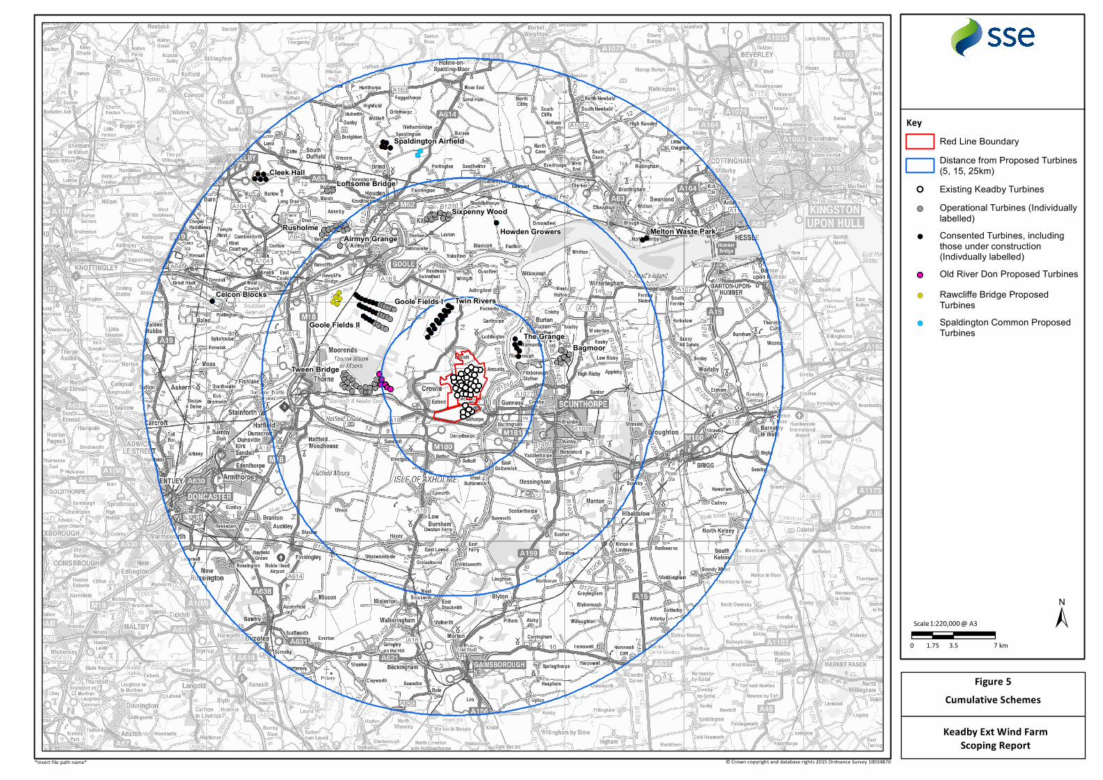
Celcon Blocks
Cleek Hall
Goole Fields IIThe Grange
Howden Growers Melton Waste Park
Spaldington Airfield
Twin RiversGoole Fields I
Rusholme
Tween Bridge
Sixpenny Wood
Airmyn Grange
Bagmoor
Loftsome Bridge
0 3.5 71.75 km
±1:220,000Scale @ A3
Cumulative SchemesFigure 5
Keadby Ext Wind FarmScoping Report
© Crown copyright and database rights 2015 Ordnance Survey 10034870*Insert file path name*
Key
Operational Turbines (Individuallylabelled)
!( Consented Turbines, includingthose under construction(Indivdually labelled)Old River Don Proposed Turbines
!( Rawcliffe Bridge ProposedTurbines
!( Spaldington Common ProposedTurbines
Existing Keadby Turbines
Distance from Proposed Turbines(5, 15, 25km)
Red Line Boundary