kemerton strategic industrial area - landcorp.com.au · eco logical australia pty ltd accepts no...
TRANSCRIPT

Kemerton Strategic Industrial Area Over-arching Environmental Management Plan Prepared for LandCorp
July 2015

K em e rt o n St ra t eg ic In d u st r i a l Ar ea
© EC O LO G IC AL A U ST R AL IA PT Y LT D ii
DOCUMENT TRACKING
Item Detail
Project Name Kemerton Strategic Industrial Area
Project Number 15PER-2185 ( previously 14PERPLA-0013 and 15PER-1066)
Project Manager Rebecca McCracken (08) 9227 1070 Suite 1 & 2, 49 Ord St, WEST PERTH WA 6005
Prepared by Benjamin Casillas-Smith
Reviewed by Michelle Doak
Approved by Michelle Doak
Status FINAL
Version Number 5
Last saved on 10 July 2015
This report should be cited as ‘Eco Logical Australia 2015. Kemerton Strategic Industrial Area: Over-arching Environmental Management Plan. Prepared for LandCorp.’
ACKNOWLEDGEMENTS
This document has been prepared by Eco Logical Australia Pty Ltd with support from LandCorp and the Department of State Development. The document is based on extensive contributing information from earlier work by Parsons Brinckerhoff including:
• Existing environmental values • Environmental management objectives • Environmental aspects to be managed and management approach (particularly with regard to
air quality, noise and waste).
Disclaimer This document may only be used for the purpose for which it was commissioned and in accordance with the contract between Eco Logical Australia Pty Ltd and LandCorp. The scope of services was defined in consultation with LandCorp and the Department of State Development, is influenced by time and budgetary constraints, and the availability of reports and other data on the subject area. Changes to available information, legislation and schedules are made on an ongoing basis and readers should obtain up to date information. Eco Logical Australia Pty Ltd accepts no liability or responsibility whatsoever for or in respect of any use of or reliance upon this report and its supporting material by any third party. Information provided is not intended to be a substitute for site specific assessment or legal advice in relation to any matter. Unauthorised use of this report in any form is prohibited.
Template 08/05/2014

K em e rt o n St ra t eg ic In d u st r i a l Ar ea
© EC O LO G IC AL A U ST R AL IA PT Y LT D iii
Contents 1 Introduction ........................................................................................................................... 7
1.1 Overview of the Kemerton Strategic Industrial Area ................................................................. 7
1.2 Purpose, scope and structure of document .............................................................................. 7
1.3 Legislative and regulatory requirements ................................................................................. 10
2 KSIA development status and history ................................................................................ 11
2.1 Land ownership/tenure .......................................................................................................... 11
2.2 Environmental assessment and approvals history .................................................................. 11
2.2.1 State process ........................................................................................................................ 11 2.2.2 Commonwealth process ........................................................................................................ 18
3 Existing environmental values............................................................................................ 19
3.1 Available biological survey and study information ................................................................... 19
3.2 Vegetation and flora .............................................................................................................. 20
3.2.1 Vegetation ............................................................................................................................. 20 3.2.2 Flora ...................................................................................................................................... 20
3.3 Terrestrial fauna .................................................................................................................... 25
3.3.1 Black Cockatoos .................................................................................................................... 26
3.4 Surface water ........................................................................................................................ 26
3.5 Groundwater ......................................................................................................................... 30
3.6 Geology and soils .................................................................................................................. 30
3.7 Landscape and visual amenity ............................................................................................... 30
3.8 Ecological linkages ................................................................................................................ 31
3.9 Heritage ................................................................................................................................ 31
4 Implementation .................................................................................................................... 37
4.1 Framework ............................................................................................................................ 37
4.2 Roles ..................................................................................................................................... 43
4.3 Environmental awareness training and inductions .................................................................. 46
4.4 Complaints/Incidents and corrective actions........................................................................... 46
4.5 Emergency response ............................................................................................................. 46
4.6 Reporting .............................................................................................................................. 46
4.7 Document review and control................................................................................................. 46
5 Environmental strategy and approach ............................................................................... 48
5.1 Environmental factors ............................................................................................................ 48
5.2 Buffer Area management ....................................................................................................... 54

K em e rt o n St ra t eg ic In d u st r i a l Ar ea
© EC O LO G IC AL A U ST R AL IA PT Y LT D iv
References ....................................................................................................................................... 57
Appendix A Constraints mapping ................................................................................................... 59
Appendix B Waste streams and indicative quantities .................................................................... 60
List of figures Figure 1: Location of Kemerton Strategic Industrial Area ....................................................................... 9
Figure 2: Current land ownership and operating facilities/industries ..................................................... 12
Figure 3: Extract of Greater Bunbury Region Scheme ......................................................................... 15
Figure 4: Extract of Shire of Harvey Town Planning Scheme No. 1 ...................................................... 16
Figure 5: Consolidated and extrapolated vegetation communities ........................................................ 21
Figure 6: Threatened and Priority Ecological Communities .................................................................. 22
Figure 7: Condition of vegetation communities .................................................................................... 23
Figure 8: Significant flora locations ...................................................................................................... 24
Figure 9: Black Cockatoo foraging habitat ........................................................................................... 27
Figure 10: Black Cockatoo potential breeding habitat .......................................................................... 28
Figure 11: Rivers and geomorphic wetlands ........................................................................................ 29
Figure 12: Groundwater contours ........................................................................................................ 33
Figure 13: Geology and soils ............................................................................................................... 34
Figure 14: Landscape and visual amenity............................................................................................ 35
Figure 15: Ecological linkages and conservation areas ........................................................................ 36
Figure 16: Future management framework .......................................................................................... 37
Figure 17: Constraints ......................................................................................................................... 42
Figure 18: Summary outline of future environmental approvals process ............................................... 43
Figure 19: KSIA management roles ..................................................................................................... 45
Figure 20: Existing offsets and potential future offset opportunities ...................................................... 56

K em e rt o n St ra t eg ic In d u st r i a l Ar ea
© EC O LO G IC AL A U ST R AL IA PT Y LT D v
List of tables Table 1: Individual project State approvals under the EP Act ............................................................... 17
Table 2: Relevant conditions from Ministerial Statement 697 and when requirements are expected to be met ..................................................................................................................................................... 39
Table 3: Environmental factors, objectives, management strategy and approach ................................. 49
Table 4: Management actions for land within the Buffer Area .............................................................. 54
Abbreviations
Abbreviation Description
AHD Australian height datum
ASS Acid sulfate soils
CCW Conservation category wetland
DAA Department of Aboriginal Affairs
DER Department of Environment Regulation
DoE Commonwealth Department of the Environment
DoP Department of Planning
DoW Department of Water
DPaW Department of Parks and Wildlife
DSD Department of State Development
EPA Environmental Protection Authority
EP Act Environmental Protection Act 1986
EPBC Act Commonwealth Environment Protection and Biodiversity Conservation Act 1999
EMP Environmental management plan/s
GBRS Greater Bunbury Region Scheme
ha Hectare/s
KSIA Kemerton Strategic Industrial Area
LWMS Local Water Management Strategy
m Metre/s
mbgl Metre/s below ground level
MUW Multiple Use category wetland

K em e rt o n St ra t eg ic In d u st r i a l Ar ea
© EC O LO G IC AL A U ST R AL IA PT Y LT D vi
Abbreviation Description
PEC Priority Ecological Community
REW Resource Enhancement category wetland
SCA No. 2 Special Control Area No. 2
TEC Threatened Ecological Community
WA Western Australia
WAPC Western Australian Planning Commission
WC Act Wildlife Conservation Act 1950

K em e rt o n St ra t eg ic In d u st r i a l Ar ea
© EC O LO G IC AL A U ST R AL IA PT Y LT D 7
1 Introduction The following document is an Over-arching Environmental Management Plan for the Kemerton Strategic Industrial Area.
1.1 Overview of the Kemerton Strategic Industrial Area
The Kemerton Strategic Industrial Area (KSIA) was established in 1985 primarily for the purpose of locating major (heavy) industry to provide downstream processing and value-adding to the South West region of Western Australia’s primary resources, in particular its substantial mineral resources, for both export and domestic markets. Although there are some existing industries and facilities in the KSIA, detailed planning for the area is still underway. This is being managed by LandCorp on behalf of the Department of State Development.
The KSIA is comprised of the following specific areas (Figure 1):
• 2024 ha of Core Industry Area – for establishment of major industries • 284 ha of Ancillary Industry Area – industry in this area will be ancillary to the heavy
industry in the Core Industry Area; ancillary meaning that the proposed development must demonstrate that the major portion of the source material, finished product, or services provided are oriented within the Kemerton area
• 5200 ha of Buffer Area – is intended to ensure that the impacts of industries located in the Core Industry Area do not adversely impact on premises beyond the boundary of the KSIA.
Development of the KSIA is expected to occur over a long-term time-frame, depending on the demand for industrial sites.
Due to the uncertain nature of strategic industry demand for land areas and servicing requirements, development of sites is intended only when required by a future proponent. Proponents may have large or no servicing requirements depending on the nature of their proposal or may elect to self-service within their own sites. Where proponents require services to be extended to their sites, this is expected to be undertaken in a coordinated way with the rest of the KSIA.
1.2 Purpose, scope and structure of document
The purpose of this Over-arching Environmental Management Plan (EMP) document is to support the current Greater Bunbury Region Scheme and local planning scheme amendment, as well as the Structure Plan submission. The document has been prepared to provide information regarding the environmental values of the KSIA as well as outlining a process and guidance for future environmental approvals and management.
The document is structured as follows:
• Section 1 – Introduction: provides an overview of the KSIA, purpose of the document and relevant legislative/regulatory requirements
• Section 2 – Project status and history: outlines the status of the project and a summary of the State and Commonwealth environmental approvals history
• Section 3 – Existing environmental values: brief overview of the key environmental values relevant to the KSIA

K em e rt o n St ra t eg ic In d u st r i a l Ar ea
© EC O LO G IC AL A U ST R AL IA PT Y LT D 8
• Section 4 – Implementation: describes the environmental management framework related to implementation of the document
• Section 5 – Environmental strategy and approach: outlines the approach to management of various relevant environmental issues.

0 1.5 3Kilometres
LegendCore Industry AreaAncillary Industry AreaBuffer AreaMain road ±
Datum/Projection: GDA 1994 MGA Zone 50
www.ecoaus.com.au
Figure 1: Location of Kemerton Strategic Industrial Area©
Eco L
ogica
l Aus
tralia
Pty.
Ltd. T
his m
ap is
not g
uaran
teed t
o be f
ree fro
m err
or or
omiss
ion. E
co Lo
gical
Austr
alia P
ty. Lt
d. an
d its
emplo
yees
disc
laim
liabil
ity fo
r any
act d
one o
n the
infor
matio
n in t
he m
ap an
d any
cons
eque
nces
of su
ch ac
ts or
omiss
ions.
Prep
ared b
y: LT
A
pprov
ed by
: MD
S
tatus
: Fina
l
Date:
20/11
/2014
P
rojec
t Cod
e: 11
4PER
PLA-
0013
Bunbury
!(
!(
!(
!(
!( Gingin
PerthMandurah
Bunbury
Albany
Regional Location
0 100 200Kilometres
Old C
oast
Road
South
Wes
tern H
ighwa
y
Leschenault Estuary

K em e rt o n St ra t eg ic In d u st r i a l Ar ea
© EC O LO G IC AL A U ST R AL IA PT Y LT D 10
1.3 Legislative and regulatory requirements
The following key Commonwealth and State environmental legislation and regulations are relevant to environmental management of the KSIA:
• Commonwealth Environment Protection and Biodiversity Conservation Act 1999 (EPBC Act)
• Environmental Protection Act 1986 (EP Act) • Environmental Protection Regulations 1987 • Environmental Protection (Clearing of Native Vegetation) Regulations 2004 • Environmental Protection (Controlled Waste) Regulations 2004 • Environmental Protection (Noise) Regulations 1997 • Aboriginal Heritage Act 1972 • Biosecurity and Agriculture Management Act 2007 • Bush Fires Act 1954 • Conservation and Land Management Act 1984 • Dangerous Goods Safety Act 2004 • Dangerous Goods Safety Regulations 2007 • Health Act 1911 • Rights in Water and Irrigation Act 1914 • Wildlife Conservation Act 1950 (WC Act).

K em e rt o n St ra t eg ic In d u st r i a l Ar ea
© EC O LO G IC AL A U ST R AL IA PT Y LT D 11
2 KSIA development status and history 2.1 Land ownership/tenure
The KSIA currently has three key categories of land ownership, specifically (Figure 2):
• LandCorp ownership (36.5%) • Department of Parks and Wildlife (DPaW) ownership (35.0%) • Private/Other ownership (28.5%).
The primary land uses are rural, industrial and conservation; with a number of specific operations/facilities currently occurring in the area (Figure 2). The KSIA will be developed over a long-term time-frame, and as such, the industrial focus of the site will expand.
2.2 Environmental assessment and approvals history
2.2.1 State process Formal advice and recommendations from the Environmental Protection Authority (EPA), specific to the KSIA, has only been issued in regard to the Greater Bunbury Region Scheme (GBRS) and Industry 2030.
Greater Bunbury Region Scheme and Industry 2030
The GBRS, which is the statutory planning framework for the region in which the KSIA is located, was referred to the EPA under the EP Act by the Western Australian Planning Commission (WAPC) in August 1996. The EPA decided to formally assess (under s48A of the EP Act) the new land use zones and reserves proposed by the GBRS, being those zones and reserves that differ from the zone or reserve shown in an existing town planning scheme for the subject land. The progress of this assessment was delayed by the Kemerton Expansion Study and Industry 2030 document, as described in detail below, with the EPA Bulletin on the GBRS not being issued until September 2003.
In August 1997, the Kemerton Expansion Study – Final Draft Report (BSD Consultants 1997) was completed. Earlier studies had resulted in a planned industry core area of ~1151 ha with a surrounding buffer area (to mitigate indirect effects from the industrial development on surrounding residents/sensitive premises) of ~4278 ha. However, in order to be considered a world-standard major industrial estate, studies indicated the need for an industry core of approximately 2000 ha, surrounded by a substantially larger buffer. The Kemerton Expansion Study (BSD Consultants 1997) proposed an expansion of the industry core to a total of 2114 ha and the buffer area to 5429 ha. This study was one of the investigations included in a report entitled Industry 2030 – Greater Bunbury Industrial Land and Port Access Planning, which was prepared by the WAPC in May 1998. The Industry 2030 document related to a number of industrial and transport areas, of which the KSIA was one.

0 0.9 1.8Kilometres
LegendCore Industry AreaAncillary Industry AreaBuffer AreaMain roadDrainage line
DPaW OwnershipLandCorp OwnershipPrivate Ownership
±Datum/Projection:
GDA 1994 MGA Zone 50
www.ecoaus.com.au
Figure 2: Current land ownership and operating facilities/industries
Prep
ared b
y: LT
A
pprov
ed by
: MD
S
tatus
: Draf
t
Date:
03/10
/2014
P
rojec
t Cod
e: 14
PERP
LA-00
13
Old C
oast
Road
Kemerton Silica Sand Mining Project
Sand Quarry Kemerton Terminal
Kemerton Lateral Gas Pipeline
Kemerton Power Station and
Enhancement Project
Stanley Road Class 1 & 2 Landfill
Silicon Smelter Project
Titanium Dioxide Pigment Plant
Kemerton WastewaterTreatment Plant
Mialla Lagoon

K em e rt o n St ra t eg ic In d u st r i a l Ar ea
© EC O LO G IC AL A U ST R AL IA PT Y LT D 13
The Industry 2030 document (which sought an increase in the industrial core area of the KSIA to 2106 ha – additional 955 ha from the original core area established in 1985) was the subject of section 16(j) advice by the EPA under the EP Act, with the following recommendations made specifically in regard to the Kemerton Expansion Study component of the Industry 2030 document (EPA Bulletin 902; August 1998):
• The EPA advises that the following modifications should be made to the Structure Plan in order to adequately protect the environment: o the western boundary of the industrial expansion area should be modified to provide
an appropriate buffer distance to the adjacent EPP Lakes (Mialla Lagoon) o land to be ceded to the Crown for conservation purposes by Kemerton Silica Sand
Pty Ltd in accordance with the Minister’s environmental conditions (Bulletin 741) should be shown as Conservation on the Structure Plan; and
o the Structure Plan should be modified to protect vegetation of regional significance pending the outcome of vegetation survey in the Kemerton area.
• The EPA also advises: o prior to finalisation of the structure plan a vegetation survey should be conducted in
the Kemerton area, on advice of the EPA, to determine the extent of regionally significant vegetation; and
o prior to finalisation of the structure plan, criteria for water management (including water supply) and a drainage management plan should be adopted due to the high water table and presence of significant wetlands and watercourses adjacent to the proposed industrial core. The criteria should aim to protect water levels and water quality in important wetlands and protect water quality in Wellesley River.
A range of other issues associated with the KSIA were discussed in EPA Bulletin 902 including buffer requirements for noise, air quality and risk; protecting regionally significant wetlands, watercourses and vegetation; maintaining a sustainable groundwater balance; protecting water quality in Wellesley River and Leschenault Inlet; Solid and liquid waste disposal; and Transport corridor locations. A number of these issues were deferred for assessment at the subsequent statutory planning stages.
EPA Bulletin 902 also outlined that it was expected that the proposed Bunbury Region Scheme, future town planning schemes, any amendments to these schemes and specific project proposals will incorporate the EPA’s advice contained in the report and undertake the recommended studies. Future schemes and projects would also need to be assessed by the EPA pursuant to the provisions of the EP Act.
In April 2000, the State Government adopted a report entitled Industry 2030 – Greater Bunbury Industrial Land and Port Access Planning (WAPC 2000), which included a Final Concept Plan for the expansion of the KSIA based on BSD Consultants’ Expansion Study (1997). Later that year, the WAPC also reflected the expanded KSIA in the draft GBRS (2000).
The draft GBRS was released for public comment in August 2000 and EPA Bulletin 1108 was published in September 2003. The two areas of the EPA Bulletin that particularly relate to the KSIA include the Kemerton Industrial Park Expansion and Special Control Area No. 2 (SCA No. 2) – Kemerton Industrial Zone Buffer. The Bulletin outlines the EPA’s position that:
• The Kemerton Industrial Expansion Area and SCA No. 2 can be managed to meet the EPA’s objectives provided a condition is imposed on the GBRS requiring that prior to subdivision or development being approved, whichever comes first, within the Kemerton

K em e rt o n St ra t eg ic In d u st r i a l Ar ea
© EC O LO G IC AL A U ST R AL IA PT Y LT D 14
Industrial Area or the SCA No. 2 an Environmental Management Plan is to be prepared and implemented to manage the potential impacts of the subdivision or development on remnant vegetation, wetlands, fauna and visual amenity
• Areas of regionally significant bushland within SCA No. 2 should be reserved as Regional Open Space (ROS) as a future amendment to the GBRS
• SCA No. 2 provides adequate separation between proposed industrial development and surrounding land uses to accommodate the impacts of noise and air quality in accordance with the EPA’s environmental objectives and criteria for these environmental factors
• The environmental factors noise, air quality, remnant vegetation, groundwater quality, surface water quality and solid/liquid waste disposal should be deferred until the land is subdivided and/or developed for industrial purposes so that the EPA can conduct a detailed environmental assessment pursuant to Part IV of the EP Act.
This advice is reflected in Ministerial Statement No 697, issued on 31 October 2005 for the GBRS, which outlines the requirements for various management plans for the KSIA.
The current GBRS indicates the KSIA has four different zonings – Industrial, Public Purposes, Rural and Regional Open Space (Figure 3); with the SCA No. 2 also demarcated. The Shire of Harvey Town Planning Scheme No. 1 indicates the KSIA is comprised of various zones (Figure 4), not all of which align with the GBRS. The Special Use area in the south of the Buffer Area is consistent between the two planning documents (even though this is not shown in Figure 4).
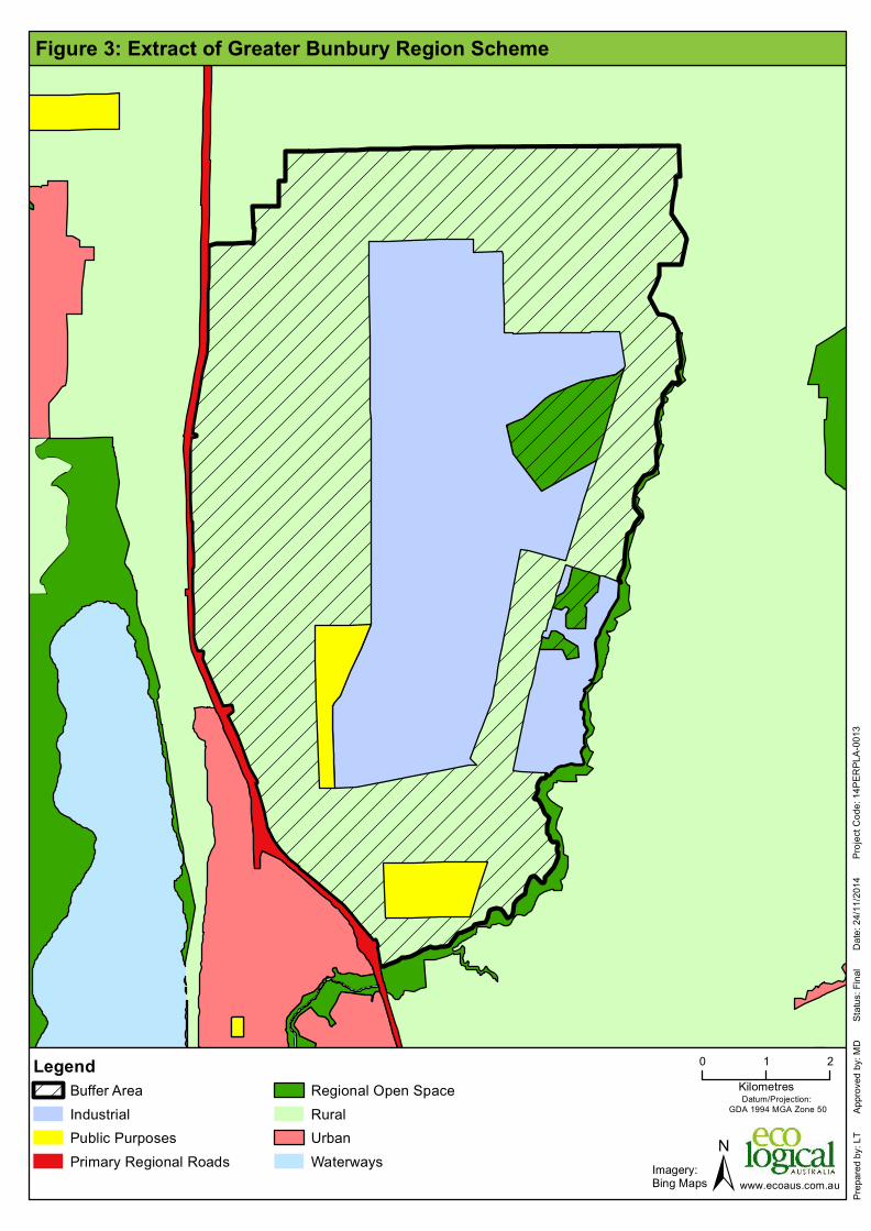
0 1 2Kilometres
LegendBuffer AreaIndustrialPublic PurposesPrimary Regional Roads
Regional Open SpaceRuralUrbanWaterways ±
Datum/Projection: GDA 1994 MGA Zone 50
www.ecoaus.com.au
Figure 3: Extract of Greater Bunbury Region Scheme
Prep
ared b
y: LT
A
pprov
ed by
: MD
S
tatus
: Fina
l
Date:
24/11
/2014
P
rojec
t Cod
e: 14
PERP
LA-00
13
Imagery:Bing Maps

0 1 2Kilometres
LegendGreater Bunbury Region Scheme Reserves
Public PurposesRegional Open Space
ZonesResidentialResidential DevelopmentSpecial ResidentialRecreation
Special RuralSpecial Rural - Landscape ProtectionInter - Industry BufferKemerton Ancillary IndustryKemerton Park IndustryKemerton BufferGeneral FarmingIntensive Farming ±
Datum/Projection: GDA 1994 MGA Zone 50
www.ecoaus.com.au
Figure 4: Extract of Shire of Harvey Town Planning Scheme No. 1
Prep
ared b
y: LT
A
pprov
ed by
: MD
S
tatus
: Fina
l
Date:
24/11
/2014
P
rojec
t Cod
e: 14
PERP
LA-00
13
Imagery:Bing Maps

K em e rt o n St ra t eg ic In d u st r i a l Ar ea
© EC O LO G IC AL A U ST R AL IA PT Y LT D 17
Individual project approvals
A number of individual projects within the KSIA have been referred and assessed under the EP Act. Those projects that have been approved for implementation by the issuing of a Ministerial Statement, are outlined below (Table 1; existing operations also shown on Figure 2).
Table 1: Individual project State approvals under the EP Act
Project title Approval date Approval documents
Titanium Dioxide Pigment Plant
August 1987 Statement 001, Bulletin 283
March 1992 (amendment) Statement 225 (s46)
March 1999 Statement 501, Bulletin 920
Silicon Smelter Project, and Mine at Moora
May 1988 Statement 027, Bulletin 328
August 1992 Statement 279, Bulletin 631 (s46)
October 2001 Statement 575, Bulletin 1027 (s46)
June 2002 Statement 593, Bulletin 1038 (s46)
May 2006 Proposal description change (s45C)
November 2009 Statement 813 (supersedes
Statements 27, 279, 575 and 593), Bulletin 1317
Chlor-Alkali Plant (Proponent and project split from Titanium Dioxide Pigment Plant project)
May 1989 Statement 066, Bulletin 336
Silica Sand Mining October 1994 Statement 366, Bulletin 741
Kemerton Silica Sand Mining Proposal, Additional mining areas and transfer of land for conservation
November 2005 Statement 703, Bulletin 1183
January 2013 Statement 920, Report 1454 (s46)
Water Supply for Kemerton Industrial Park
September 1996 Statement 427, Bulletin 758
Kemerton Wastewater Treatment Plant and Treated Wastewater Reuse at Woodlot Binningup
June 2001 Statement 568, Bulletin 1011
Kemerton Power Station February 2004 Statement 645, Bulletin 1121
Dampier to Bunbury Natural Gas Pipeline, Kemerton Lateral Gas Pipeline
November 2005 Statement 704, Bulletin 1204
Kemerton Power Station Enhancement Project
August 2007 Statement 745, Bulletin 1258
Extension of Kemerton Silica Sand Dredge Mining
November 2012 Statement 916, Report 1425

K em e rt o n St ra t eg ic In d u st r i a l Ar ea
© EC O LO G IC AL A U ST R AL IA PT Y LT D 18
In addition to those aforementioned EP Act approved projects, a number of other smaller scale activities/developments have been established (e.g. landfill sites).
2.2.2 Commonwealth process The KSIA has not been referred or considered under the EPBC Act either strategically, as a plan for an industrial park, or as an overall industrial project. As such, no overall Commonwealth approval applies to development within the KSIA.
Three individual projects with components that occur within the KSIA have been referred to the Commonwealth Department of the Environment (DoE) under the EPBC Act, with two assessed, as follows:
• Kemerton Silica Sand Mine Expansion (EPBC 2002/910) – approved subject to conditions on 4 April 2013
• Dampier to Bunbury Natural Gas Pipeline, Kemerton Lateral Gas Pipeline Project (EPBC 2005/2388) – not a controlled action decision issued 7 December 2005
• Western Power Binningup Desalination Plant Transmission Line (EPBC 2008/4484) – reconsideration decision not controlled action if undertaken in a particular manner issued on 9 September 2010.
K em e rt o n St ra t eg ic In d u st r i a l Ar ea
© EC O LO G IC AL A U ST R AL IA PT Y LT D 19
3 Existing environmental values 3.1 Available biological survey and study information
Numerous biological surveys have been undertaken within and surrounding the KSIA in the past, including:
• Eco Logical Australia (ELA) (2014) Targeted Ecological Surveys for Kemerton Industrial Park
• AECOM (2012) ‘Kemerton Industrial Park: Threatened Orchid Survey’ • Bamford Consulting (2011) ‘Black Cockatoo and Western Ringtail Possum Habitat
Assessment, Kemerton Industrial Park, Bunbury’ • Mattiske Consulting (Mattiske) (2011a) ‘EPBC Act Significance Criteria Review of the
Proposed Kemerton Industrial Park Development’ • Mattiske Consulting (Mattiske) (2011b) ‘EPBC Act Significance Test of the Proposed
Subdivision of 510 Marriott Road, Kemerton’ • Mattiske Consulting (Mattiske) (2011c) ‘Vegetation condition mapping for the Kemerton
Industrial Area’ • Cardno (2010a) ‘Kemerton Industrial Core: Flora and Vegetation Survey’ • Cardno (2010b) ‘Kemerton Industrial Core: Fauna Survey’ • Coffey Environments (Coffey) (2008) ‘Flora, Vegetation, Wetlands and Fauna Assessment
Kemerton Industrial Park’ • Coffey Environments (Coffey) (2007) ‘Kemerton Industrial Park Environmental Overview
for the KIP Strategy Plan’ • Paul Armstrong and Associates (2007) ‘Review of Vegetation Types Monitored within the
Kemerton Industrial Estate and Identification of Deficiencies’ • Bamford and Bamford (1999) ‘Kemerton Fauna Study and Review’ • Muir Environmental (Muir) (1999a) ‘Report of Biological Survey – Phase 1: Kemerton
Industrial Estate Volume 1 Report’ • Muir Environmental (Muir) (1999b) ‘Summary Report – Kemerton Industrial Area Phase 1
Biological Survey’ • Muir Environmental (Muir) (1999c) ‘Vegetation community mapping of the Kemerton
Industrial Area’ • Paul Armstrong and Associates (1999a) ‘Kemerton Industrial Estate (Original Core Zone)
Spring 1999 Rare Flora Search’ • Paul Armstrong and Associates (1999b) ‘Kemerton Industrial Estate (Expanded Core
Zone) Mid- and Late Spring 1999 Rare Flora Search’ • Paul Armstrong and Associates (1999c) ‘Kemerton Industrial Estate (Support Industry
Area) Mid- and Late Spring 1999 Rare Flora Search’.
The following sections describing the existing environmental values of the KSIA (referred to as ‘the site’) have generally been summarised from these previous survey reports.

K em e rt o n St ra t eg ic In d u st r i a l Ar ea
© EC O LO G IC AL A U ST R AL IA PT Y LT D 20
3.2 Vegetation and flora
3.2.1 Vegetation Seven vegetation communities have been identified as occurring within the site, including three wetland communities (Figure 5). Two Priority Ecological Communities (PECs) and one Threatened Ecological Community (TEC) have been identified as occurring within the site (Figure 6):
• ‘Southern Swan Coastal Plain Eucalyptus gomphocephala – Agonis flexuosa woodlands’ (PEC), represented by vegetation communities EgAf and EmEdAf. The degraded areas of EgAf were not considered to be extant occurrences of the ‘Southern Swan Coastal Plain Eucalyptus gomphocephala – Agonis flexuosa woodlands’ PEC due to the poor vegetation condition and were mapped as such
• ‘Low lying Banksia attenuata woodlands or shrublands’ (PEC), represented by vegetation communities EmCcBa and BaBiKg
• ‘Shrublands and Woodlands on Muchea Limestone of the Swan Coastal Plain’ (TEC)
The majority of the vegetation within the site is mapped as being in excellent condition (approximately 40%) and nearly a third is mapped as completely degraded (Figure 7). The remainder of the vegetation is mapped as mainly very good condition, with smaller areas in good or degraded condition, or are mapped as plantations. Areas mapped as being in excellent condition mostly coincided with vegetation community boundaries in the northern, southern and western portions of the site. Degraded or completely degraded areas mainly occurred on the outside edges of the Buffer Area, generally coinciding with parklands and other cleared areas.
Substantial areas of the vegetation communities present in the Buffer Area have been historically cleared from the Swan Coastal Plain. As such, the presence of these contiguous and excellent/very good/good condition vegetation communities in the Buffer Area is significant as they support a range of habitat types for flora and fauna species. In addition, the two PECs occurring in the site are not well represented outside of National Parks and Conservation Reserves (Coffey 2007).
3.2.2 Flora A total of five Threatened flora species (all orchids) are known to occur within the site (ELA 2014) (Figure 8):
• Caladenia procera1 (EPBC Act: Critically Endangered, WC Act: Threatened) • Diuris drummondii (EPBC Act: Vulnerable, WC Act: Threatened) • Diuris micrantha (EPBC Act: Vulnerable, WC Act: Threatened) • Drakaea elastica (EPBC Act: Endangered, WC Act: Threatened) • Drakaea micrantha (EPBC Act: Vulnerable, WC Act: Threatened).
An additional orchid species, Caladenia huegelii (EPBC Act: Endangered, WC Act: Threatened) was identified by ELA (2014) as potentially occurring in the KSIA. This species was not recorded in the KSIA by ELA (2014) despite extensive searches in suitable habitat in the KSIA. It has been recorded previously approximately 3 km south-west of the KSIA along the Leschenault Estuary (DEC 2012).
1 One population of Caladenia procera is known to occur on private property within the Buffer Area. To maintain confidentiality of the location, the specific location has not been described and is not shown on Figure 8.

0 1 2Kilometres
LegendCore Industry AreaAncillary Industry AreaBuffer AreaMain road ±
Datum/Projection: GDA 1994 MGA Zone 50
www.ecoaus.com.au
Figure 5: Consolidated and extrapolated vegetation communities©
Eco L
ogica
l Aus
tralia
Pty.
Ltd. T
his m
ap is
not g
uaran
teed t
o be f
ree fro
m err
or or
omiss
ion. E
co Lo
gical
Austr
alia P
ty. Lt
d. an
d its
emplo
yees
disc
laim
liabil
ity fo
r any
act d
one o
n the
infor
matio
n in t
he m
ap an
d any
cons
eque
nces
of su
ch ac
ts or
omiss
ions.
Prep
ared b
y: LT
A
pprov
ed by
: MD
S
tatus
: Fina
l
Date:
20/1`
/2014
P
rojec
t Cod
e: 14
PERP
LA-00
13
Imagery:Bing MapsData Sources:Coffey (2010a)Muir (1999c)Mattiske (2011)
Old C
oast
Road
1. EmCcBa
! ! ! !
! ! ! !
! ! ! ! 2. EmEdAf3. BaBiKg4. MpKgNf5. MpErMr6. MrMlAs7. EgAf (non-extant)8. EgAf (Extant)Unknown (PrivateProperty)PlantationsRevegetationCleared PaddocksInfrastructure or Cleared AreaParkland
Vegetation Communities

0 0.8 1.6Kilometres
LegendCore Industry AreaAncillary Industry AreaBuffer AreaMain road ±
Datum/Projection: GDA 1994 MGA Zone 50
www.ecoaus.com.au
Figure 6: Threatened and Priority Ecological Communities©
Eco L
ogica
l Aus
tralia
Pty.
Ltd. T
his m
ap is
not g
uaran
teed t
o be f
ree fro
m err
or or
omiss
ion. E
co Lo
gical
Austr
alia P
ty. Lt
d. an
d its
emplo
yees
disc
laim
liabil
ity fo
r any
act d
one o
n the
infor
matio
n in t
he m
ap an
d any
cons
eque
nces
of su
ch ac
ts or
omiss
ions.
Prep
ared b
y: LT
A
pprov
ed by
: MD
S
tatus
: Draf
t
Date:
03/10
/2014
P
rojec
t Cod
e: 14
PERF
ED-00
13
Imagery:Bing Maps
Old C
oast
Road
TECShrublands and woodlands on Muchea LimestoneApproximated boundary of Shrublands and woodlands on Muchea Limestone
PECLow lying Banksia attenuata woodlands or shrublands (Priority 3)Southern Swan Coastal Plain Eucalyptus gomphocephala -Agonis flexuosa woodlands (Priority 3)
Threatened/Priority Ecological Communities

0 0.8 1.6Kilometres
LegendCore Industry AreaAncillary Industry AreaBuffer AreaMain road ±
Datum/Projection: GDA 1994 MGA Zone 50
www.ecoaus.com.au
Figure 7: Condition of vegetation communities©
Eco L
ogica
l Aus
tralia
Pty.
Ltd. T
his m
ap is
not g
uaran
teed t
o be f
ree fro
m err
or or
omiss
ion. E
co Lo
gical
Austr
alia P
ty. Lt
d. an
d its
emplo
yees
disc
laim
liabil
ity fo
r any
act d
one o
n the
infor
matio
n in t
he m
ap an
d any
cons
eque
nces
of su
ch ac
ts or
omiss
ions.
Prep
ared b
y: LT
A
pprov
ed by
: MD
S
tatus
: Fina
l
Date:
20/11
/2014
P
rojec
t Cod
e: 14
PERP
LA-00
13
Imagery:Bing Maps
Old C
oast
Road
ExcellentVery GoodGoodDegradedCompletely DegradedPlantation
Vegetation Condition
Data Sources:Mattiske (2011)

0 0.8 1.6Kilometres
LegendCore Industry AreaAncillary Industry AreaBuffer AreaMain road ±
Datum/Projection: GDA 1994 MGA Zone 50
www.ecoaus.com.au
Figure 8: Significant flora locations©
Eco L
ogica
l Aus
tralia
Pty.
Ltd. T
his m
ap is
not g
uaran
teed t
o be f
ree fro
m err
or or
omiss
ion. E
co Lo
gical
Austr
alia P
ty. Lt
d. an
d its
emplo
yees
disc
laim
liabil
ity fo
r any
act d
one o
n the
infor
matio
n in t
he m
ap an
d any
cons
eque
nces
of su
ch ac
ts or
omiss
ions.
Prep
ared b
y: LT
A
pprov
ed by
: JC
S
tatus
: Fina
l
Date:
20/11
/2014
P
rojec
t Cod
e: 13
PERE
CO-00
19
Imagery:Bing Maps
Old C
oast
Road
DRF") Diuris drummondii") Diuris micrantha") Drakaea elastica") Drakaea micrantha
Priority 1!( Boronia juncea subsp. juncea
Priority 3!( Dillwynia dillwyniodes!( Lasiopetalum membranaceum
Priority 4XW Acacia flagelliformisXW Acacia semitrullataXW Caladenia speciosaXW Microtis quadrataXW Pultenaea skinneri
Possible DRF_̂ Drakaea micrantha?
Priority Flora Locations*
*Data Sources:Cardno (2010)AECOM (2012)DEC (2012)ELA (2013)
K em e rt o n St ra t eg ic In d u st r i a l Ar ea
© EC O LO G IC AL A U ST R AL IA PT Y LT D 25
One additional Threatened flora species; Caladenia huegelii (EPBC Act: Endangered, WC Act: Threatened) could potentially occur within the site as it has been recorded approximately 3 kilometres south-west of the site along the Leschenault Estuary (DEC 2012).
The following eight Priority flora species are known to occur within the site:
• Boronia juncea subsp. juncea (Priority 1) • Dillwynia dillwynioides (Priority 3) • Lasiopetalum membranaceum (Priority 3) • Acacia semitrullata (Priority 4) • Acacia flagelliformis (Priority 4) • Caladenia speciosa (Priority 4) • Microtis quadrata (Priority 4) • Pultenaea skinneri (Priority 4).
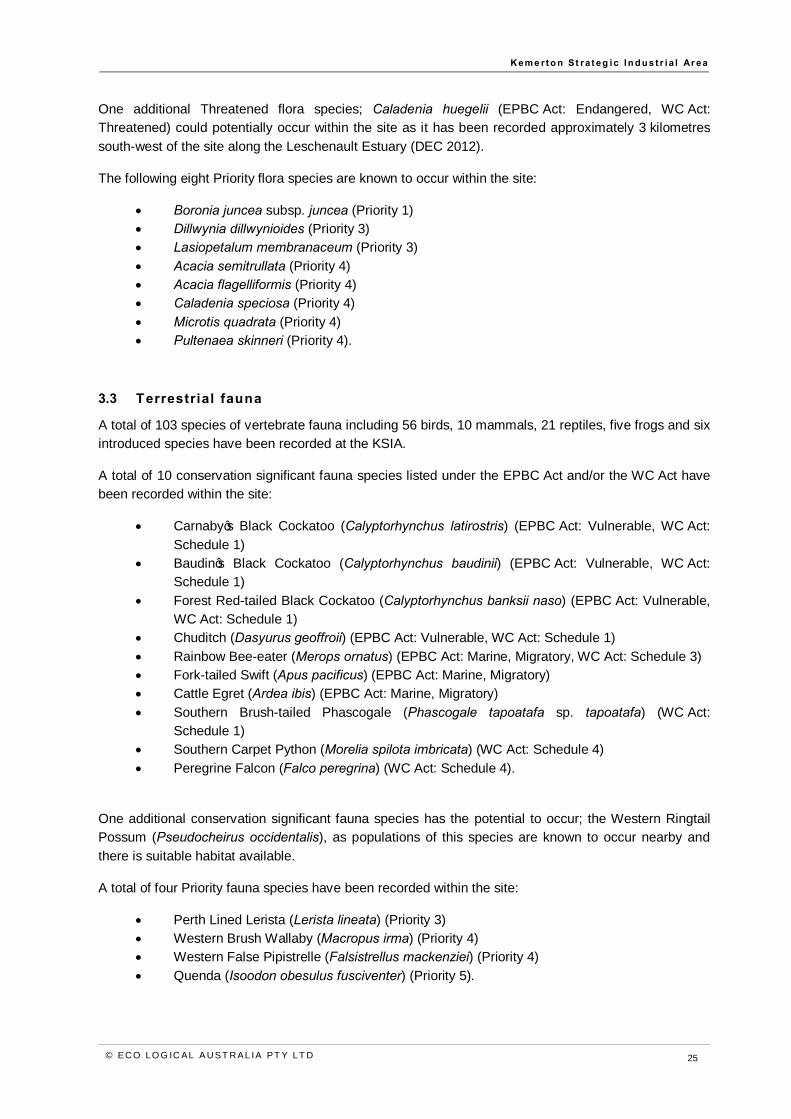
3.3 Terrestrial fauna
A total of 103 species of vertebrate fauna including 56 birds, 10 mammals, 21 reptiles, five frogs and six introduced species have been recorded at the KSIA.
A total of 10 conservation significant fauna species listed under the EPBC Act and/or the WC Act have been recorded within the site:
• Carnaby’s Black Cockatoo (Calyptorhynchus latirostris) (EPBC Act: Vulnerable, WC Act: Schedule 1)
• Baudin’s Black Cockatoo (Calyptorhynchus baudinii) (EPBC Act: Vulnerable, WC Act: Schedule 1)
• Forest Red-tailed Black Cockatoo (Calyptorhynchus banksii naso) (EPBC Act: Vulnerable, WC Act: Schedule 1)
• Chuditch (Dasyurus geoffroii) (EPBC Act: Vulnerable, WC Act: Schedule 1) • Rainbow Bee-eater (Merops ornatus) (EPBC Act: Marine, Migratory, WC Act: Schedule 3) • Fork-tailed Swift (Apus pacificus) (EPBC Act: Marine, Migratory) • Cattle Egret (Ardea ibis) (EPBC Act: Marine, Migratory) • Southern Brush-tailed Phascogale (Phascogale tapoatafa sp. tapoatafa) (WC Act:
Schedule 1) • Southern Carpet Python (Morelia spilota imbricata) (WC Act: Schedule 4) • Peregrine Falcon (Falco peregrina) (WC Act: Schedule 4).
One additional conservation significant fauna species has the potential to occur; the Western Ringtail Possum (Pseudocheirus occidentalis), as populations of this species are known to occur nearby and there is suitable habitat available.
A total of four Priority fauna species have been recorded within the site:
• Perth Lined Lerista (Lerista lineata) (Priority 3) • Western Brush Wallaby (Macropus irma) (Priority 4) • Western False Pipistrelle (Falsistrellus mackenziei) (Priority 4) • Quenda (Isoodon obesulus fusciventer) (Priority 5).

K em e rt o n St ra t eg ic In d u st r i a l Ar ea
© EC O LO G IC AL A U ST R AL IA PT Y LT D 26
Potential habitat occurs within the site for the Barking Owl (Ninox connivens connivens) (Priority 2) and the Masked Owl (Tyto novaehollandiae novaehollandia) (Priority 3), however, these two species have not been recorded.
3.3.1 Black Cockatoos Foraging evidence of all three Black Cockatoo species has been observed within the site and was recorded at 76 locations during the most recent survey, comprising chewed Banksia, Jarrah, Marri and Pinus (Pine) cones (ELA 2014). Black Cockatoos were also observed opportunistically within the site during the ELA (2014) survey at 19 locations. These records include Forest Red-tailed Black Cockatoos feeding on Jarrah and Marri, and Carnaby’s Cockatoos flying in small to medium sized flocks through the site. The assessment and mapping of potential foraging habitat values depicted in Figure 9 was based primarily on the density of known Black Cockatoo food plants being present (ELA 2014).
Due to the range of land use practices and vegetation condition, foraging and potential breeding habitat for Black Cockatoos within the site is highly variable (Figure 9 and Figure 10). However, high quality habitat is extensive within the Buffer and Core Industry areas due to a number of vegetation communities being dominated by Eucalyptus and Banksia species.
Many potential breeding trees recorded during the ELA (2014) survey (particularly Marri, Jarrah and Tuart) within the site had hollows considered to be potentially suitable for Black Cockatoo breeding, although no signs of nesting or breeding behaviour were observed. Potential breeding habitat for Black Cockatoos within the KSIA was highly variable; vegetation communities with the highest value included those comprising Marri, Jarrah and Tuart, and to a lesser degree Flooded Gum (ELA 2014). The primary basis for the breeding habitat value rating depicted in Figure 10 was the size and density of potential breeding trees, rather than the presence of nesting hollows (ELA 2014).
3.4 Surface water
The Wellesley River; the only major watercourse in the vicinity of the site (Figure 11), is one of the main river systems flowing into the Brunswick River, which merges with the Collie River prior to discharging into the Leschenault Inlet (Coffey 2007). The Wellesley River appears to act as a perennial drain for the local groundwater system (Coffey 2007).
Wetlands occur in the northern, central, southern and western portions of the site (Figure 11). This suite of wetlands is regarded as one of the largest remaining aggregations of relatively undisturbed wetlands within the largely cleared Swan Coastal Plain (Coffey 2007). The wetlands within the site are generally perched wetlands, groundwater fed basins (sumplands and damplands), or part of a seasonally waterlogged palusplain and include wetlands classified by DPaW under the following categories (WAPC 2005):
• Conservation category wetland (CCW) • Resource Enhancement category wetland (REW) • Multiple Use category wetland (MUW).
Wetlands that are identified as CCWs are also defined as Environmentally Sensitive Areas under the EP Act. A number of the wetlands in the site are also protected under the Environmental Protection (Swan Coastal Plain Lakes) Policy 1992.

0 1 2Kilometres
LegendCore Industry AreaAncillary Industry AreaBuffer AreaMain road ±
Datum/Projection: GDA 1994 MGA Zone 50
www.ecoaus.com.au
Figure 9: Black Cockatoo foraging habitat©
Eco L
ogica
l Aus
tralia
Pty.
Ltd. T
his m
ap is
not g
uaran
teed t
o be f
ree fro
m err
or or
omiss
ion. E
co Lo
gical
Austr
alia P
ty. Lt
d. an
d its
emplo
yees
disc
laim
liabil
ity fo
r any
act d
one o
n the
infor
matio
n in t
he m
ap an
d any
cons
eque
nces
of su
ch ac
ts or
omiss
ions.
Prep
ared b
y: LT
A
pprov
ed by
: MD
S
tatus
: Fina
l
Date:
20/11
/2014
P
rojec
t Cod
e: 14
PERF
ED-00
13
Imagery:Bing Maps
Old C
oast
Road
HighModerate to HighModerateLowNoUnknown (Private Property)
Foraging Category

0 1 2Kilometres
LegendCore Industry AreaAncillary Industry AreaBuffer AreaMain road ±
Datum/Projection: GDA 1994 MGA Zone 50
www.ecoaus.com.au
Figure 10: Black Cockatoo potential breeding habitat©
Eco L
ogica
l Aus
tralia
Pty.
Ltd. T
his m
ap is
not g
uaran
teed t
o be f
ree fro
m err
or or
omiss
ion. E
co Lo
gical
Austr
alia P
ty. Lt
d. an
d its
emplo
yees
disc
laim
liabil
ity fo
r any
act d
one o
n the
infor
matio
n in t
he m
ap an
d any
cons
eque
nces
of su
ch ac
ts or
omiss
ions.
Prep
ared b
y: LT
A
pprov
ed by
: MD
S
tatus
: Fina
l
Date:
20/11
/2014
P
rojec
t Cod
e: 14
PERF
ED-00
13
Imagery:Bing Maps
Old C
oast
Road
Breeding HabitatHigh Breeding Habitat ValueModerate Breeding Habitat ValueNo Breeding Habitat ValueUnknown (Private Property)

0 0.9 1.8Kilometres
LegendCore Industry AreaAncillary Industry AreaBuffer AreaMain roadEPP Lakes (EPA 1992)
Geomorphic WetlandsConservationResource Enhancement
±Datum/Projection:
GDA 1994 MGA Zone 50
www.ecoaus.com.au
Figure 11: Rivers and geomorphic wetlands
Prep
ared b
y: LT
A
pprov
ed by
: MD
S
tatus
: Fina
l
Date:
24/11
/2014
P
rojec
t Cod
e: 14
PERP
LA-00
13
Imagery:Bing Maps
Old C
oast
Road

K em e rt o n St ra t eg ic In d u st r i a l Ar ea
© EC O LO G IC AL A U ST R AL IA PT Y LT D 30
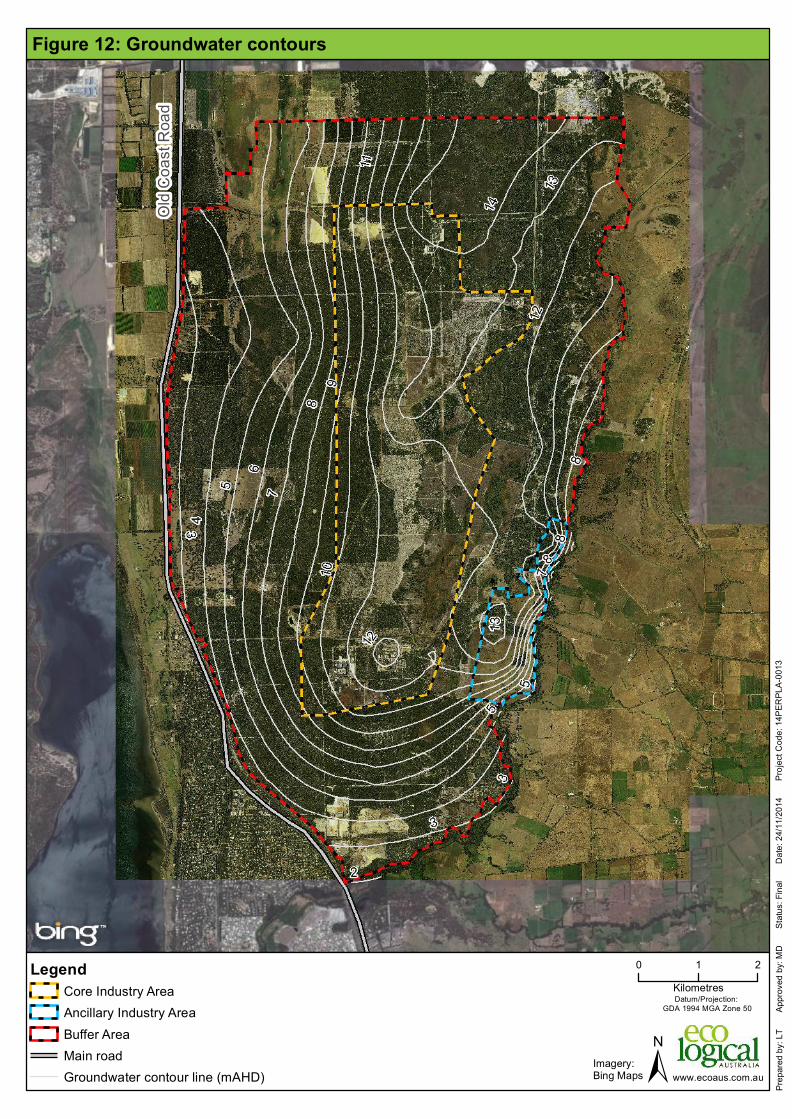
3.5 Groundwater
There are four distinct groundwater units based on hydrogeology across and underlying the site:
• Superficial aquifer: unconfined aquifer approximately 20 – 40 m thick, recharged by rainfall • Leederville aquifer: confined aquifer mainly recharged by downward leakage from the
overlying superficial aquifer • Yarragadee aquifer: underlies the Leederville Aquifer and is only present in the southern
part of the KSIA • Cattamarra Coal Measures aquifer: confined multi-layered aquifer.
Groundwater mapping shows the average maximum groundwater level is at approximately 6 m Australian Height Datum (AHD) to 14 m AHD which indicates the depth to groundwater within the site generally ranges between 40 metres below ground level (mbgl) at the Spearwood sand dune ridge (Section 3.7) and 0-5 mbgl through the central and eastern parts of the KSIA (Figure 12). In the central and eastern parts of the KSIA, there are areas where groundwater occurs at a depth of less than 2 mbgl, which are associated with the wetlands in these areas. Groundwater quality is generally poor, with high levels of suspended solids and nutrient levels above the Australian and New Zealand guidelines for fresh and marine water quality (ANZECC 2000), water quality guideline for wetlands.
3.6 Geology and soils
The majority of the site is underlain by superficial Bassendean Sand overlying the Leederville Formation which overlies either the Yarragadee Formation or the Catamarra Coal Measures in the western portion of the site. The superficial geology (Quarternary) consists of sand, limestone, silt and clay units of the Guildford Formation, Bassendean Sand, Spearwood Sand and Tamala Limestone. Peaty sand deposits can also occur within swamps and wetlands. The variation in lithology is evident both vertically and laterally, with the thickness ranging between 20 m and 50 m.
The presence of wetlands and coffee rock within the site indicate the potential for Acid Sulfate Soils (ASS). Mapping by the Department of Environment Regulation (DER) and Landgate show two risk categories for ASS in WA:
• High to moderate risk of ASS occurring within 3 m of natural soil surface • Moderate to low risk of ASS occurring within 3 m of natural soil surface but high to
moderate risk of ASS beyond 3 m of natural soil surface. A High to moderate risk of ASS occurs in the west of the site, and in patches along the east of the site generally associated with the location of wetlands (Figure 13). A moderate to low risk of ASS occurs across the majority of the eastern half of the site and along the western boundary.
3.7 Landscape and visual amenity
A landscape assessment of the site was undertaken by William James Landscape Architect in 2007 (WJLA 2007). The study identified the following three Landscape Character Units of the Swan Coastal Plain as relevant to the site (Figure 14):
• Ridge – the ridgeline of a Spearwood sand dune running in a north-south direction through the western centre of the site, rising to 45 m above sea level and averaging 35-50 m above sea level with slopes ranging from 5-20%
• Bassendean Plain – a flat landform of Bassendean sands marked by minor creek lines and numerous wetland basins, covering the eastern half of the site

K em e rt o n St ra t eg ic In d u st r i a l Ar ea
© EC O LO G IC AL A U ST R AL IA PT Y LT D 31
• Yoongarillup Plain – an almost flat plain of Spearwood sands covering the area of the site to the west of the ridge.
Land use character is an influential factor on the experience an individual has of a location. There are three land use characteristics that influence the site; industrial, rural and forestry/plantations. Areas of industrial land use occur in the Core Industry Area and rural land use occurs to the east and west. Australian hardwood forest plantations are scattered throughout the Core Industry Area and Buffer Area. The site can be viewed from the following locations:
• Old Coast Road • South West Highway • Perth to Bunbury rail line • Binningup and residential areas to the west and south-west • Binningup Road • Marriot Road • Wellesley Road • Other rural roads to the east • Rural properties on the foothills of the Darling Range and in the vicinity of the Buffer and
Core Industry Area • Special rural lots within the Core Industry Area (these are currently leased and will be
vacated as industrial development proceeds).
A ‘Ridge landscape priority’ area has previously been identified in Industry 2030 for the site and this is also shown on Figure 14.
3.8 Ecological linkages
Two ecological linkages defined as ‘constrained’ under the Greater Bunbury Regional Scheme (EPA 2003) occur in close proximity to, or within the site; the McLarty/Kemerton/Twin Rivers/Preston River/Gwindinnup and the Leschenault/Kemerton Link (EPA 2003) (Figure 15). Figure 15 shows the indicative orientation of these linkages in the landscape within and surrounding the KSIA. The orientation depicted on Figure 15 does not demarcate the boundary, statutory or otherwise, of the linkages. The linkages have been identified as providing a regional biodiversity function, by linking significant remnant vegetation patches within the south-west region. The Kemerton Nature Reserve also occurs in the north-east of the KSIA.
3.9 Heritage
An Aboriginal Heritage Survey of the Core Industry Area was conducted in 2011 by Brad Goode and Associates (2011). As a result of consultations with nominated members of the Gnaala Karla Booja WC98/58 Native Title Claim group no ethnographic sites of significance, as defined by section 5 of the Aboriginal Heritage Act 1972 were identified.
One registered archaeological site was confirmed to occur within the Core Industry Area; Department of Aboriginal Affairs (DAA) 4887 Marriott Road consisting of artefact scatters. The site is located on the south-western side of the river in an exposed yellow sandbank at the junction of Wellesley River and Devlin Road. No other archaeological sites were found.

K em e rt o n St ra t eg ic In d u st r i a l Ar ea
© EC O LO G IC AL A U ST R AL IA PT Y LT D 32
A search of the Department of Aboriginal Affairs (DAA) Aboriginal Heritage Inquiry System indicates that there may be archaeological/ethnographic sites in the Buffer Area, which was excluded from the 2011 survey.
The KSIA does not contain any sites on the Register of the Western Australian Heritage Commission (now Heritage Council of Western Australia) (WJLA 2007).
0 1 2Kilometres
LegendCore Industry AreaAncillary Industry AreaBuffer AreaMain roadGroundwater contour line (mAHD) ±
Datum/Projection: GDA 1994 MGA Zone 50
www.ecoaus.com.au
Figure 12: Groundwater contours
Prep
ared b
y: LT
A
pprov
ed by
: MD
S
tatus
: Fina
l
Date:
24/11
/2014
P
rojec
t Cod
e: 14
PERP
LA-00
13
Imagery:Bing Maps
Old C
oast
Road

0 1 2Kilometres
LegendCore Industry AreaAncillary Industry AreaBuffer AreaMain road
Acid sulfate soilsHigh to moderate riskModerate to low risk
±Datum/Projection:
GDA 1994 MGA Zone 50
www.ecoaus.com.au
Figure 13: Geology and soils
Prep
ared b
y: LT
A
pprov
ed by
: MD
S
tatus
: Fina
l
Date:
24/11
/2014
P
rojec
t Cod
e: 14
PERP
LA-00
13
Imagery:Bing Maps
Old C
oast
Road
Coastal deposits, includingbeaches and coastal dunesExposed rock, saprolite, andsaprockLacustrine deposits, includinglakes, playas, and fringing dunesSandplain, mainly eolian,including some residual deposits
Regolith
Data Source:DPaW (2014)

0 1 2Kilometres
LegendCore Industry AreaAncillary Industry AreaBuffer AreaMain road
RidgeBassendean PlainYoongarillup PlainContour line (m)
Ridge Landscape Priority
±Datum/Projection:
GDA 1994 MGA Zone 50
www.ecoaus.com.au
Figure 14: Landscape and visual amenity
Prep
ared b
y: LT
A
pprov
ed by
: MD
S
tatus
: Draf
t
Date:
16/03
/2015
P
rojec
t Cod
e: 14
PERP
LA-00
13
Imagery:Bing Maps
Old C
oast
Road
Data Source:WJLA (2007)Landgate (2013)

0 0.9 1.8Kilometres
LegendCore Industry AreaAncillary Industry AreaBuffer AreaMain roadDrainage line
Ecological linkageKemerton Nature Reserve
±Datum/Projection:
GDA 1994 MGA Zone 50
www.ecoaus.com.au
Figure 15: Ecological linkages and conservation areas
Prep
ared b
y: LT
A
pprov
ed by
: MD
S
tatus
: Draf
t
Date:
03/10
/2014
P
rojec
t Cod
e: 14
PERP
LA-00
13
Imagery:Bing Maps
Old C
oast
Road
Leschenault/KemertonEcological Linkage
McLarty/Kemerton/Twin Rivers/
Preston River/Gwindinup
Ecological Linkage
K em e rt o n St ra t eg ic In d u st r i a l Ar ea
© EC O LO G IC AL A U ST R AL IA PT Y LT D 37
4 Implementation 4.1 Framework
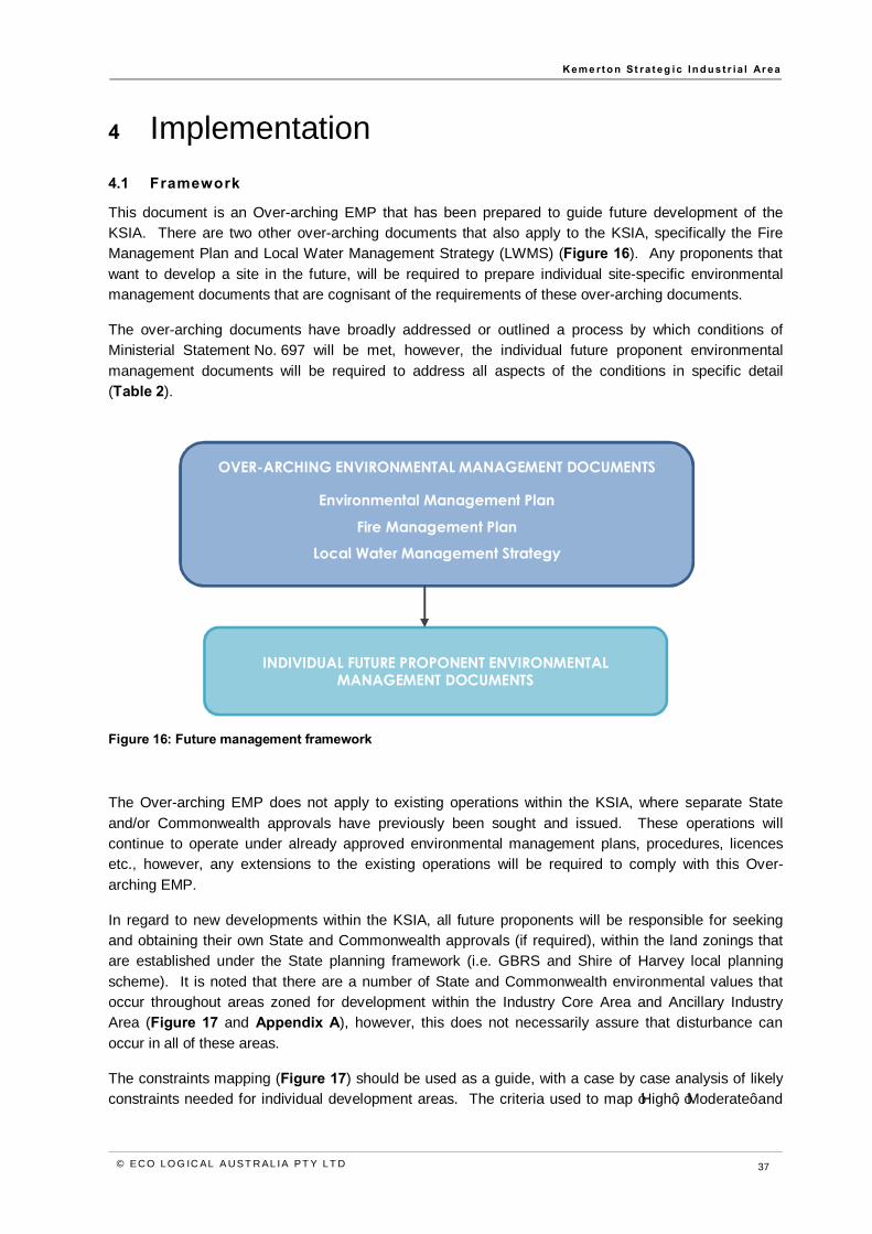
This document is an Over-arching EMP that has been prepared to guide future development of the KSIA. There are two other over-arching documents that also apply to the KSIA, specifically the Fire Management Plan and Local Water Management Strategy (LWMS) (Figure 16). Any proponents that want to develop a site in the future, will be required to prepare individual site-specific environmental management documents that are cognisant of the requirements of these over-arching documents.
The over-arching documents have broadly addressed or outlined a process by which conditions of Ministerial Statement No. 697 will be met, however, the individual future proponent environmental management documents will be required to address all aspects of the conditions in specific detail (Table 2).
Figure 16: Future management framework
The Over-arching EMP does not apply to existing operations within the KSIA, where separate State and/or Commonwealth approvals have previously been sought and issued. These operations will continue to operate under already approved environmental management plans, procedures, licences etc., however, any extensions to the existing operations will be required to comply with this Over-arching EMP.
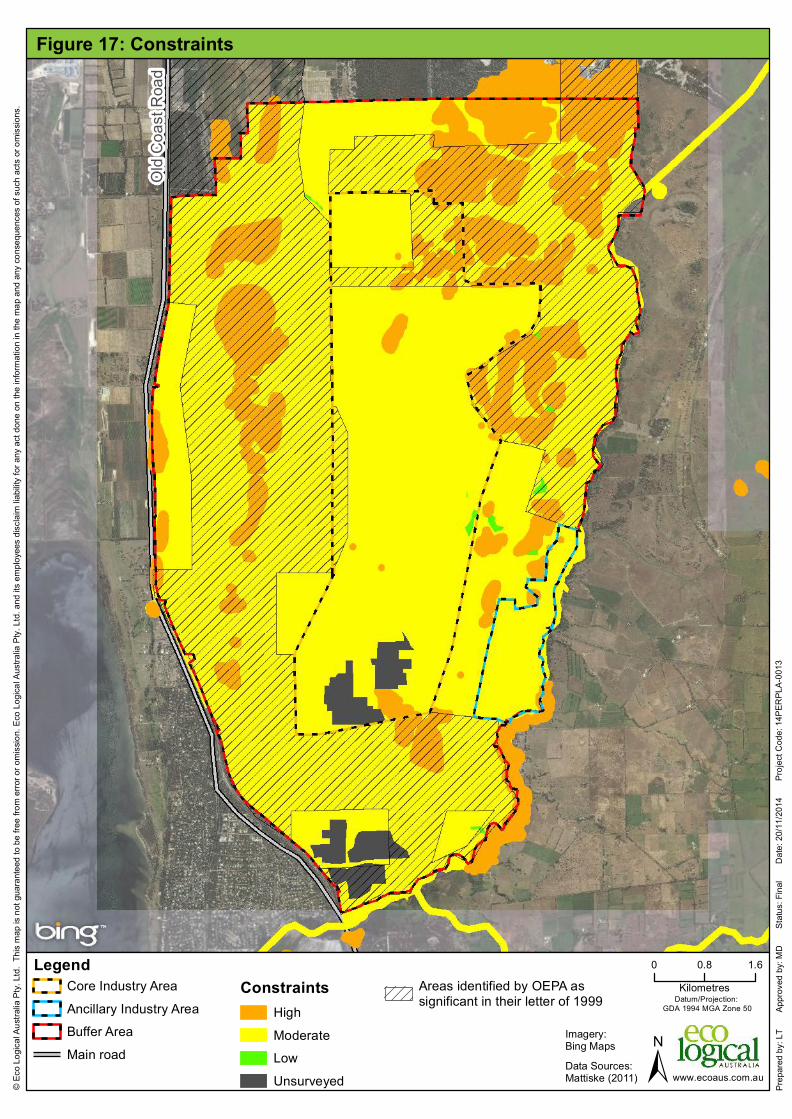
In regard to new developments within the KSIA, all future proponents will be responsible for seeking and obtaining their own State and Commonwealth approvals (if required), within the land zonings that are established under the State planning framework (i.e. GBRS and Shire of Harvey local planning scheme). It is noted that there are a number of State and Commonwealth environmental values that occur throughout areas zoned for development within the Industry Core Area and Ancillary Industry Area (Figure 17 and Appendix A), however, this does not necessarily assure that disturbance can occur in all of these areas.
The constraints mapping (Figure 17) should be used as a guide, with a case by case analysis of likely constraints needed for individual development areas. The criteria used to map ‘High’, ‘Moderate’ and
OVER-ARCHING ENVIRONMENTAL MANAGEMENT DOCUMENTS
Environmental Management Plan
Fire Management Plan
Local Water Management Strategy
INDIVIDUAL FUTURE PROPONENT ENVIRONMENTAL MANAGEMENT DOCUMENTS

K em e rt o n St ra t eg ic In d u st r i a l Ar ea
© EC O LO G IC AL A U ST R AL IA PT Y LT D 38
‘Low’ constraints are provided in Appendix A. Approval requirements such as avoidance and offsets will be determined through the necessary approvals process. One or more of the aspects of constraint may apply to an area of land; the type and complexity of the individual constraint/s will influence the level and ease of approvals. It is possible that some of these areas will not be able to be developed due to the environmental values present. A summary outline of the future process with regard to environmental approvals is provided in Figure 18.
K em e rt o n St ra t eg ic In d u st r i a l Ar ea
© EC O LO G IC AL A U ST R AL IA PT Y LT D 39
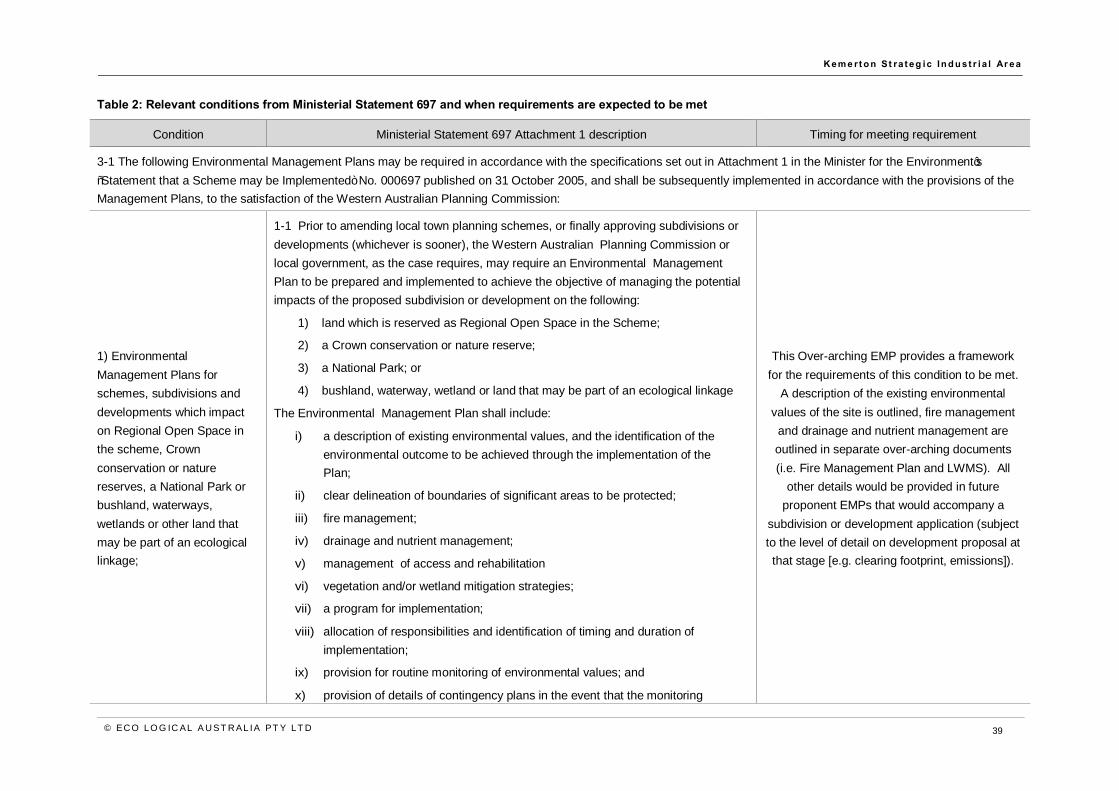
Table 2: Relevant conditions from Ministerial Statement 697 and when requirements are expected to be met
Condition Ministerial Statement 697 Attachment 1 description Timing for meeting requirement
3-1 The following Environmental Management Plans may be required in accordance with the specifications set out in Attachment 1 in the Minister for the Environment’s “Statement that a Scheme may be Implemented” No. 000697 published on 31 October 2005, and shall be subsequently implemented in accordance with the provisions of the Management Plans, to the satisfaction of the Western Australian Planning Commission:
1) Environmental Management Plans for schemes, subdivisions and developments which impact on Regional Open Space in the scheme, Crown conservation or nature reserves, a National Park or bushland, waterways, wetlands or other land that may be part of an ecological linkage;
1-1 Prior to amending local town planning schemes, or finally approving subdivisions or developments (whichever is sooner), the Western Australian Planning Commission or local government, as the case requires, may require an Environmental Management Plan to be prepared and implemented to achieve the objective of managing the potential impacts of the proposed subdivision or development on the following:
1) land which is reserved as Regional Open Space in the Scheme;
2) a Crown conservation or nature reserve;
3) a National Park; or
4) bushland, waterway, wetland or land that may be part of an ecological linkage
The Environmental Management Plan shall include:
i) a description of existing environmental values, and the identification of the environmental outcome to be achieved through the implementation of the Plan;
ii) clear delineation of boundaries of significant areas to be protected;
iii) fire management;
iv) drainage and nutrient management;
v) management of access and rehabilitation
vi) vegetation and/or wetland mitigation strategies;
vii) a program for implementation;
viii) allocation of responsibilities and identification of timing and duration of implementation;
ix) provision for routine monitoring of environmental values; and
x) provision of details of contingency plans in the event that the monitoring
This Over-arching EMP provides a framework for the requirements of this condition to be met.
A description of the existing environmental values of the site is outlined, fire management and drainage and nutrient management are outlined in separate over-arching documents (i.e. Fire Management Plan and LWMS). All
other details would be provided in future proponent EMPs that would accompany a
subdivision or development application (subject to the level of detail on development proposal at that stage [e.g. clearing footprint, emissions]).

K em e rt o n St ra t eg ic In d u st r i a l Ar ea
© EC O LO G IC AL A U ST R AL IA PT Y LT D 40
Condition Ministerial Statement 697 Attachment 1 description Timing for meeting requirement
surveys indicate that the development is having or has had an adverse impact upon environmental values.
1-2 Environmental Management Plans required by condition 1-1 shall be prepared to the satisfaction of the Western Australian Planning Commission or local government, as the case requires, having due regard for advice from relevant government agencies and shall be implemented in accordance with a program defined in the Environmental Management Plan.
2) Environmental Management Plans for industrial development within the Kemerton Industrial Area and Special Control Area No. 2;
2-1 Prior to approving subdivision or development within the Kemerton Industrial Area and the Special Control Area No. 2, the Western Australian Planning Commission or local government, as the case requires, may require an Environmental Management Plan to be prepared and implemented to achieve the objective of managing the potential impacts of the proposed development.
The Environmental Management Plan shall include:
1) a description of existing environmental values (including vegetation, fauna and wetlands) and the identification of the environmental outcome to be achieved through the implementation of this Plan;
2) management of potential impacts on visual amenity;
3) clear delineation of significant areas to be protected;
4) a program for implementation;
5) allocation of responsibilities and identification of timing and duration of implementation;
6) provision for routine monitoring of environmental values; and
7) provision of details of contingency plans in the event that the monitoring surveys indicate that the subdivision or development is having or has had an adverse impact upon environmental values.
This Over-arching EMP provides a framework for the requirements of this condition to be met.
A description of the existing environmental values of the site is outlined, however, all other details would be provided in future proponent EMPs that would accompany a subdivision or
development application (subject to the level of detail on development proposal at that stage
[e.g. clearing footprint, emissions]).
2-2 An Environmental Management Plan required by condition 2-1 shall be prepared to the satisfaction of the Western Australian Planning Commission or local government, as the case requires, having due regard for advice from relevant government agencies and

K em e rt o n St ra t eg ic In d u st r i a l Ar ea
© EC O LO G IC AL A U ST R AL IA PT Y LT D 41
Condition Ministerial Statement 697 Attachment 1 description Timing for meeting requirement
shall be implemented in accordance with a program defined in the Environmental Management Plan.
3) Drainage, Nutrient and Water Management Plans in areas where the Average Maximum Groundwater Level is less than 1.2 metres below the natural ground surface or where any proposed off-site drainage could lead to degradation of wetlands or waterways; and
3-1 Prior to amending local town planning schemes, or finally approving subdivision or developments (including those for intensive horticulture), whichever is sooner, in areas where the Average Maximum Groundwater Level is less than 1.2 metres below the natural ground surface, or where any proposed off-site drainage could lead to degradation of wetlands or waterways, the Western Australian Planning Commission or local government, as the case requires, may require a Drainage, Nutrient and Water Management Plan to be prepared and implemented.
An over-arching LWMS has been prepared in accordance with the Better Urban Water
Management Guidelines. Future Proponents would be required to prepare documentation consistent with the over-arching LWMS and
Better Urban Water Management Guidelines for more detailed plans, in consultation with the
Department of Water.
3-2 A Drainage, Nutrient and Water Management Plan, if required, shall ensure that there is no net increase in nitrogen export to the Leschenault Estuary as a result of development within the Greater Bunbury Region.
3-3 The Drainage, Nutrient and Water Management Plan shall be prepared to the satisfaction of the Western Australian Planning Commission or local government, as the case requires, having due regard for advice from relevant government agencies, and shall be implemented in accordance with a program defined in the Drainage, Nutrient and Water Management Plan.
4) Acid Sulfate Soil Management Plans where the presence of acid sulfate soils is confirmed or there is likely to be a significant risk of disturbing acid sulfate soils.
4-1 Prior to amending local town planning schemes, or finally approving subdivisions or development, the Western Australian Planning Commission or local government, as the case requires, may require a Preliminary Acid Sulfate Soils Assessment to be prepared where there is likely to be a significant risk of disturbing acid sulfate soils.
At the time of submitting a subdivision or development application (subject to the level of detail on development proposal at that stage
[e.g. clearing footprint, excavation requirements]), future proponents would need to undertake relevant investigations and prepare
management plans as required.
4-2 Where the presence of acid sulfate soils is confirmed, an Acid Sulphate Soil Management Plan shall be prepared to the satisfaction of the Western Australian Planning Commission or local government, as the case requires, having due regard for advice from relevant government agencies and implemented in accordance with a program defined in the Acid Sulphate Soil Management Plan.
0 0.8 1.6Kilometres
LegendCore Industry AreaAncillary Industry AreaBuffer AreaMain road
ConstraintsHighModerateLowUnsurveyed
Areas identified by OEPA assignificant in their letter of 1999
±Datum/Projection:
GDA 1994 MGA Zone 50
www.ecoaus.com.au
Figure 17: Constraints©
Eco L
ogica
l Aus
tralia
Pty.
Ltd. T
his m
ap is
not g
uaran
teed t
o be f
ree fro
m err
or or
omiss
ion. E
co Lo
gical
Austr
alia P
ty. Lt
d. an
d its
emplo
yees
disc
laim
liabil
ity fo
r any
act d
one o
n the
infor
matio
n in t
he m
ap an
d any
cons
eque
nces
of su
ch ac
ts or
omiss
ions.
Prep
ared b
y: LT
A
pprov
ed by
: MD
S
tatus
: Fina
l
Date:
20/11
/2014
P
rojec
t Cod
e: 14
PERP
LA-00
13
Imagery:Bing Maps
Old C
oast
Road
Data Sources:Mattiske (2011)

K em e rt o n St ra t eg ic In d u st r i a l Ar ea
© EC O LO G IC AL A U ST R AL IA PT Y LT D 43
Figure 18: Summary outline of future environmental approvals process
4.2 Roles
The following State agencies/land owners have a key role in the future environmental management of the KSIA (Figure 19):
• Department of State Development (DSD) • LandCorp • Department of Parks and Wildlife (DPaW) • Private landowners • WAPC/Department of Planning (DoP) • Shire of Harvey • Department of Water (DoW) • Environmental Protection Authority (EPA) • Department of Environment Regulation (DER) • Department of Aboriginal Affairs (DAA).
Proponent develops new project
Details for Proponent to determine/confirm:
- Footprint extent - Environmental values affected/impacts expected (including noise, air quality, remnant vegetation, groundwater, surface water, solid/liquid waste)
State or Commonwealth approval/s required?
Yes No
Proponent prepares any documentation that may be required and follow appropriate process
This could include referral forms, assessment
documentation, offset determination and negotiation
of approval conditions

K em e rt o n St ra t eg ic In d u st r i a l Ar ea
© EC O LO G IC AL A U ST R AL IA PT Y LT D 44
These roles are generally associated with land owner/manager or statutory responsibilities under State legislation. DPaW is a land owner within the KSIA Core Industry Area and Buffer Area, however, it is also expected that over time this agency would be responsible for management of increasing portions of the Buffer Area as land is progressively protected for conservation purposes.
The Commonwealth Department of the Environment (DoE) also has a role in the environmental management of the KSIA as it relates to approval conditions issued for projects that could impact Matters of National Environmental Significance protected under the EPBC Act.
It is likely that an industry body will be established in the future to share information and coordinate any monitoring requirements that apply to the entire site.

K em e rt o n St ra t eg ic In d u st r i a l Ar ea
© EC O LO G IC AL A U ST R AL IA PT Y LT D 45
Figure 19: KSIA management roles
Kemerton Strategic Industrial
Area
DPaW Major land
owner
LandCorp Major land
owner/lessor and land developer
Private landowners Manage their
estate
DSD Lead agency
DAA Aboriginal heritage
management
Shire of Harvey
Statutory planning decision maker Manage public
infrastructure (i.e. roads)
DoW Water
management
EPA Part IV
approvals DER Part V
approvals
WAPC/DoP Statutory planning decision maker
K em e rt o n St ra t eg ic In d u st r i a l Ar ea
© EC O LO G IC AL A U ST R AL IA PT Y LT D 46
4.3 Environmental awareness training and inductions
Industry operators will ensure that all personnel, including subcontractors, are subjected to a site induction program which will include an environmental component. The site specific induction will communicate:
• Requirements of relevant environmental management documentation (over-arching documents as well as proponent specific documents)
• Significant environmental values to be protected • Control strategies for the management of environmental risk in day-to-day activities • Roles and responsibilities for implementing management, monitoring and reporting
associated with the environment • Applicable legislative responsibilities and requirements and the risks associated with non-
compliance.
Additional training will be provided to personnel, where applicable, which might include spill response or fire and emergency response.
Records of training and inductions will be maintained by industry operators in a training register.
4.4 Complaints/ Incidents and corrective actions
All environmental incidents/complaints and ‘near misses’ will be recorded within a register to be developed and maintained by each industry operator. Incidents will be recorded by the person who causes or identifies the incident and complaints will be recorded by the person who receives the complaint (at the time it is received). Records to be obtained in regard to a complaint include:
• Contact details for person making complaint (name and phone number) • Approximate location that issue was identified by complainant (e.g. east or west of site,
1 km or 10 km from site) • Date, time and issue/s that complaint relates to.
Incidents/complaints and ‘near misses’ will be investigated and appropriate measures implemented to prevent recurrence. Where applicable, environmental incidents will be reported to the relevant government agency.
4.5 Emergency response
An Emergency Response Plan shall be prepared by each commercial/industrial operator within the KSIA, if there is not one in place already. The Emergency Response Plan will outline any requirements for on-site Fire/Emergency Wardens and First Aid Officers.
4.6 Reporting
Individual proponent reporting of performance and adherence to environmental management requirements will be undertaken consistent with statutory requirements.
4.7 Document review and control
This Over-arching EMP will be revised and updated as required in response to updated baseline information, changed legal requirements or continual improvement opportunities.

K em e rt o n St ra t eg ic In d u st r i a l Ar ea
© EC O LO G IC AL A U ST R AL IA PT Y LT D 47
Relevant government agencies will be consulted and amended approvals will be sought, where applicable, when changes to this document are proposed that are inconsistent with the currently established objectives.
K em e rt o n St ra t eg ic In d u st r i a l Ar ea
© EC O LO G IC AL A U ST R AL IA PT Y LT D 48
5 Environmental strategy and approach This section of the document has been prepared to outline a process and guidance for future environmental approvals and management. All future proponents will be responsible for seeking and obtaining their own State and Commonwealth approvals (if required), with any management requirements/conditions determined for individual proponents and imposed on them under relevant legislation in the future.
5.1 Environmental factors
Objectives, environmental management strategy and approach have been developed for the following environmental factors relevant to the KSIA (Table 3):
• Flora and vegetation • Landform • Subterranean fauna • Terrestrial environmental quality • Terrestrial fauna • Hydrological processes • Inland waters environmental quality • Air quality and atmospheric gases • Amenity • Heritage • Human health.

K em e rt o n St ra t eg ic In d u st r i a l Ar ea
© EC O LO G IC AL A U ST R AL IA PT Y LT D 49
Table 3: Environmental factors, objectives, management strategy and approach
Issue Environmental
factor Environmental
objective/s Strategy and approach
Biodiversity
Flora and vegetation
Terrestrial fauna
Subterranean fauna
Hydrological processes
Flora and vegetation – to maintain
representation, diversity, viability and ecological function at
the species, population and community level.
Terrestrial and subterranean fauna – to maintain representation,
diversity, viability and ecological function at
the species, population and assemblage level.
Hydrological processes – to maintain the
hydrological regimes of groundwater and
surface water so that existing and potential
uses, including ecosystem
maintenance, are protected.
Key steps to be undertaken to achieve the biodiversity management objectives for each proposed new operation within the KSIA is as follows:
• Identify and discuss in documentation the environmental values that occur within the proposed development area (this includes vegetation, flora, fauna and their habitat, wetlands and their buffers, and ecological linkages)
• Determine the aspects of the new development that could affect these environmental values (including direct, indirect and cumulative impacts in the context of other projects within the KSIA). Determine the significance of the impacts to the environmental values and whether referral of the project to the EPA under the EP Act is required (EPA Environmental Assessment Guideline No. 9: Application of a significance framework in the environmental impact assessment process, will facilitate this determination)
• Identify mitigation measures that could be implemented to avoid, minimise, rectify or reduce impacts to the environmental values, in accordance with the Environmental Impact Assessment (Part IV Divisions 1 and 2) Administrative Procedures 2012 (gazetted on 7 December 2012)
• Determine the offsets that may be appropriate in regard to any significant residual impacts to the environmental values.
Where relevant environmental values are likely to be affected, the above steps may require State and/or Commonwealth assessment and approval processes. These processes will determine the extent to which impacts can occur and the conditions that might apply to implementation of the project, if approved, which could include offsets.
The State and Commonwealth regulatory agencies do have documentation available to facilitate determination of appropriate offsets for biodiversity values. It is expected that the Buffer Area of the KSIA will be utilised for some of the offsets for future developments (further information regarding potential offsets in the Buffer Area is contained in Section 5.2).
A Fire Management Plan has been developed for the KSIA. Future proponents will need to be consistent with its requirements.
Surface and Hydrological A LWMS has been prepared to guide future development within the KSIA and protect surface and groundwater resources. Future

K em e rt o n St ra t eg ic In d u st r i a l Ar ea
© EC O LO G IC AL A U ST R AL IA PT Y LT D 50
Issue Environmental
factor Environmental
objective/s Strategy and approach
groundwater processes
Inland waters environmental
quality
proponents will need to prepare an Urban Water Management Plan consistent with the LWMS and Better Urban Water Management Guidelines, in consultation with DoW.
ASS
Terrestrial environmental
quality
Hydrological processes
Inland waters environmental
quality
Terrestrial environmental quality – to maintain the quality
of land and soils so that the environment values,
both ecological and social, are protected.
Hydrological processes – to maintain the
hydrological regimes of groundwater and
surface water so that existing and potential
uses, including ecosystem
maintenance, are protected.
Inland waters environmental quality – to maintain the quality of groundwater and
surface water, sediment and biota so that the
environmental values, both ecological and
Key steps to be undertaken to achieve the ASS management objectives for each proposed new operation within the KSIA is as follows:
• Undertake an ASS assessment to confirm the presence and extent of ASS within areas to be disturbed (either directly by excavation activities or indirectly by dewatering)
• Where ASS disturbance will occur, prepare a management plan (outline mitigation measures and monitoring requirements) to manage any potential adverse impacts in accordance with State Guidelines on ASS and consultation with DER.

K em e rt o n St ra t eg ic In d u st r i a l Ar ea
© EC O LO G IC AL A U ST R AL IA PT Y LT D 51
Issue Environmental
factor Environmental
objective/s Strategy and approach
social, are protected.
Landscape and visual amenity
Not applicable
Maintain the dominant natural/rural character of the Buffer Area and
minimise industrial land use character influence acting on land outside
the Buffer Area.
Key steps to be undertaken to achieve the landscape and visual amenity management objective for each proposed new operation within the KSIA is as follows:
• Complete a landscape and visual amenity assessment, in consideration of the existing landscape, to determine extent of impact
• Identify options to minimise impacts on landscape and visual amenity.
This information will be provided by future proponents and reviewed on a case-by-case basis, as may be required by regulatory authorities (e.g. WAPC or local government authority).
Aboriginal heritage
Heritage
To ensure that historical and cultural
associations, and natural heritage, are not
adversely affected.
Key steps to be undertaken to achieve the Aboriginal heritage management objective for each proposed new operation within the KSIA is as follows:
• Confirm whether any Aboriginal heritage sites occur within the proposed disturbance areas for the new operation
• Determine options to avoid identified Aboriginal heritage sites, or where this is not possible seek approval to disturb the site in accordance with the Aboriginal Heritage Act 1972
• Ensure management procedures are in place in the event of identification of a previously unknown Aboriginal heritage site (e.g. during excavation activities).
Air quality
Air quality and atmospheric
gases
Human health
Air quality and atmospheric gases – to maintain air quality for the protection of the
environment and human health and amenity, and
to minimise the emission of greenhouse and other atmospheric
gases through the application of best
Key steps to be undertaken to achieve the air quality management objective for each proposed new operation within the KSIA are as follows:
• Identify potentially sensitive noise receptors, including residential properties, hospitals, hotels, caravan parks, schools, places of worship, aged care facilities, child care facilities, shopping centres and playgrounds (and excluding commercial and industrial premises within the KSIA)
• Identify potential sources of air emissions (including dust, odour and pollutant), including existing industrial premises and operations located within the KSIA
• Measure baseline air quality levels and determine appropriate threshold air quality levels at the nearest identified potentially sensitive receptors/Buffer Area boundary (whichever is the closest) consistent with the State and/or National air quality policies

K em e rt o n St ra t eg ic In d u st r i a l Ar ea
© EC O LO G IC AL A U ST R AL IA PT Y LT D 52
Issue Environmental
factor Environmental
objective/s Strategy and approach
practice.
Human health – to ensure that human
health is not adversely affected.
• Model predicted air quality levels at identified potentially sensitive receptors/Buffer Area boundary in consideration of existing sources of emissions and proposed new sources of emissions
• Determine control measures that can be implemented to minimise pollutants
• Determine an appropriate air quality monitoring strategy (including monitoring sites and frequency) to ensure identified air quality thresholds are not exceeded at potentially sensitive receptors/Buffer Area boundary
• Ongoing measurement of air quality levels at identified sensitive receptors/Buffer Area boundary and reporting results as required.
All future proponents will undertake an assessment of the incremental and cumulative impacts associated with their proposed development and existing operations within the KSIA.
It is expected that a coordinated approach to air quality monitoring within the KSIA may be required in the future to monitor cumulative impacts as the KSIA more fully develops. Landowners will be expected to coordinate this monitoring if it is required and report results to the appropriate regulatory agencies as required.
Noise Amenity
Human health
Amenity – to ensure that impacts to amenity are reduced as low as reasonably practicable.
Human health – to ensure that human
health is not adversely affected.
Key steps to be undertaken to achieve the noise management objective for each proposed new operation within the KSIA are as follows:
• Identify potentially sensitive noise receptors, including residential properties, hospitals, hotels, caravan parks, schools, places of worship, aged care facilities, child care facilities, shopping centres and playgrounds (and excluding commercial and industrial premises within the KSIA)
• Identify potential sources of noise, including existing industrial premises and operations located within the KSIA
• Measure baseline noise levels and determine appropriate threshold noise levels at the nearest identified potentially sensitive receptors/Buffer Area boundary (whichever is the closest) consistent with the Environmental Protection (Noise) Regulations 1997
• Model predicted noise levels at identified potentially sensitive receptors/Buffer Area boundary in consideration of existing sources of noise, proposed new sources of noise and the calculated Influencing Factor
• Determine control measures that can be implemented to minimise noise
• Determine an appropriate noise monitoring strategy (including monitoring sites and frequency) to ensure identified noise thresholds are not exceeded at potentially sensitive receptors/Buffer Area boundary

K em e rt o n St ra t eg ic In d u st r i a l Ar ea
© EC O LO G IC AL A U ST R AL IA PT Y LT D 53
Issue Environmental
factor Environmental
objective/s Strategy and approach
• Ongoing measurement of noise levels at identified sensitive receptors/Buffer Area boundary and reporting results as required.
All future proponents will undertake an assessment of the incremental and cumulative impacts associated with their proposed development and existing operations within the KSIA.
It is expected that a coordinated approach to noise monitoring within the KSIA may be required in the future to monitor cumulative impacts as the KSIA more fully develops. Landowners will be expected to coordinate this monitoring if it is required and report results to the appropriate regulatory agencies as required.
Waste
Terrestrial environmental
quality
Inland waters environmental
quality
Human health
Terrestrial environmental quality – to maintain the quality
of land and soils so that the environment values,
both ecological and social, are protected.
Inland waters environmental quality – to maintain the quality of groundwater and
surface water, sediment and biota so that the
environmental values, both ecological and
social, are protected.
Human health – to ensure that human
health is not adversely affected.
Waste streams from the KSIA will include gaseous, liquid and solid wastes (refer to Appendix B for further details), however, the exact types of waste and their quantities will be dependent on the particular industries that establish in the area.
Some wastes could be utilised as inputs for other industries (particularly waste water, subject to treatment options and certain water quality criteria). Clustering of certain industries to facilitate trading and recycling of materials would likely result in a reduction in wastes that require disposal at landfill sites. A solid waste recycling facility, expandable water factory (to process multiple sources of waste water) and expandable energy factory (to receive hot waste gases and potentially supply electrical energy, steam, hot air, hot oil, cooling and compressed air) would be potential solutions to reduce landfill disposal. It is possible that a new landfill site would be required to service the KSIA in the future, however, the capacity, function and location of this potential facility has not been determined.
Detailed waste characterisation for each industry will be required to accurately determine the type and quantity of waste generated, and that required to be disposed of (noting that this could include landfill disposal, and water discharges to land or via ocean outfall etc.). This information will be provided by future proponents and reviewed on a case-by-case basis, as required by applicable legislation (including the EP Act and EPBC Act).

K em e rt o n St ra t eg ic In d u st r i a l Ar ea
© EC O LO G IC AL A U ST R AL IA PT Y LT D 54
5.2 Buffer Area management
The primary objective of the Buffer Area is to ensure that the impacts of industries located in the Core Industry Area do not adversely impact on premises beyond the boundary of the KSIA.
It is acknowledged that there is land within the Buffer Area (including land zoned as Regional Open Space) that is currently owned and managed by DPaW for biodiversity conservation purposes (some of this land was historically transferred to DPaW for conservation management as part of the overall concept for development of the KSIA). It is expected that biodiversity conservation management within the Buffer Area will increase in the future as offsets are determined for future projects. There are a number of options for biodiversity offsets arising from development in the Core Industry Area, within the Buffer Area, including:
• Provision of funding for active management of existing vegetation/habitat (e.g. weed control, fencing)
• Rehabilitation of degraded vegetation communities (including wetlands) • Transfer of land ownership to DPaW, with future management requirements • Reserving land to Regional Open Space/Conservation (rather than Rural zoning) • Utilising Conservation Covenants to determine use/management of land • Establishing a Class A Nature Reserve.
A number of offsets have already been established in the Buffer Area, and further opportunities for potential offsets have been identified (Figure 20). Potential future offsets will need to comply with the following EPA guidance regarding offsets:
• WA Environmental Offsets Policy (EPA 2011) • Environmental Protection Bulletin No. 1: Environmental Offsets (EPA 2014a) • WA Environmental Offsets Guidelines (EPA 2014b).
A range of minimum management requirements have been developed for land in the Buffer Area, to minimise risks associated with degradation of the remaining native vegetation (Table 4).
Table 4: Management actions for land within the Buffer Area
MANAGEMENT ACTION
Access
Vehicles will be limited to existing access or fire tracks, as far as practicable (i.e. may not be possible in case of a fire).
Fire management
A Fire Management Plan has been developed for the KSIA. Buffer Area management will need to be consistent with its requirements.
Hygiene management
Hygiene measures for prevention of spread of weeds and dieback will be implemented including:
• Inspecting and cleaning equipment and vehicles prior to entering site with native vegetation
• Footwear/ tyres will be cleaned prior to entry to site with native vegetation.
Rubbish removal

K em e rt o n St ra t eg ic In d u st r i a l Ar ea
© EC O LO G IC AL A U ST R AL IA PT Y LT D 55
MANAGEMENT ACTION
Remove litter/rubbish on a regular basis as required.
Revegetation
Flora species to be utilised in revegetation works will be those previously recorded during surveys, or other species identified as occurring within the Buffer Area.
Where seedlings are to be planted, seedlings are to be produced from a nursery that is accredited by the Nursery Industry Accreditation Scheme Australia, specifically to reduce the risk of dieback introductions.
Feral animal control
Ongoing review of feral animals (particularly rabbits, foxes and pigs) on-site and develop control program if required.
A detailed Buffer Area Management Plan (including monitoring requirements) is expected to be developed in the future as the area being managed for conservation is further consolidated.

0 0.9 1.8Kilometres
LegendCore Industry AreaAncillary Industry AreaBuffer AreaMain roadDrainage line
Existing offset areaDPaW OwnershipLandCorp OwnershipPrivate Ownership ±
Datum/Projection: GDA 1994 MGA Zone 50
www.ecoaus.com.au
Figure 20: Existing offsets and land ownership
Prep
ared b
y: LT
A
pprov
ed by
: MD
S
tatus
: Draf
t
Date:
03/10
/2014
P
rojec
t Cod
e: 14
PERP
LA-00
13
Imagery:Bing Maps
Old C
oast
Road

K em e rt o n St ra t eg ic In d u st r i a l Ar ea
© EC O LO G IC AL A U ST R AL IA PT Y LT D 57
References AECOM 2012. Kemerton Industrial Park: Threatened Orchid Survey. Report prepared for LandCorp.
ANZECC 2000. Australian and New Zealand guidelines for fresh and marine water quality – guidelines (Volume 1). National Water Quality Management Strategy.
Bamford and Bamford 1999. Kemerton Fauna Study and Review. Unpublished report.
Bamford Consulting 2011. Black Cockatoo and Western Ringtail Possum Habitat Assessment, Kemerton Industrial Park, Bunbury. Report prepared for Parsons Brinckerhoff.
Brad Goode and Associates 2011. A Site Identification Aboriginal Heritage Survey of the Proposed Kemerton Industrial Park in the Shire of Harvey, Western Australia. A report prepared for the South West Aboriginal Land & Sea Council (SWALSC) on behalf of Landcorp.
BSD Consultants (1997) Kemerton Expansion Study - Final Draft Report, Volumes 1 & 2. Report prepared for Department of Resources Development, LandCorp, Western Australian Planning Commission and South West Development Corporation, June 1997.
Cardno 2010a. Kemerton Industrial Core: Flora and Vegetation Survey. Report prepared for LandCorp.
Cardno 2010b. Kemerton Industrial Core: Fauna Survey. Report prepared for LandCorp.
Coffey Environments 2007. Kemerton Industrial Park Environmental Overview for the KIP Strategy Plan. Report Number 2006/117 prepared for LandCorp.
Coffey Environments 2008. Flora, Vegetation, Wetlands and Fauna Assessment Kemerton Industrial Park. Report prepared for Thompson McRobert Edgeloe.
Department of Environment and Conservation (DEC) 2012. Threatened and Priority flora database search. Reference number 23_1212. Species and Communities Branch, Department of Environment and Conservation, Western Australia.
Eco Logical Australia (ELA) 2014. Targeted Ecological Surveys for Kemerton Industrial Park. Unpublished report prepared for Landcorp, May 2014.
Environmental Protection Authority (EPA) 2014a. Environmental Protection Bulletin No. 1: Environmental Offsets. EPA, Perth, Western Australia.
Environmental Protection Authority (EPA) 2014b. WA Environmental Offsets Guidelines. EPA, Perth, Western Australia.
Environmental Protection Authority (EPA) 2011. WA Environmental Offsets Policy. EPA, Perth, Western Australia.
Environmental Protection Authority (EPA) 2003. Bulletin 1108: Greater Bunbury Region Scheme. Environmental Protection Authority, Perth.
Environmental Protection Authority (EPA) 1998. Bulletin 902: Industry 2030 – Greater Bunbury industrial land and port access planning. Environmental Protection Authority, Perth.

K em e rt o n St ra t eg ic In d u st r i a l Ar ea
© EC O LO G IC AL A U ST R AL IA PT Y LT D 58
Mattiske Consulting 2011a. EPBC Act Significance Criteria Review of the Proposed Kemerton Industrial Park Development. Report prepared for Parsons Brinckerhoff on behalf of LandCorp.
Mattiske Consulting 2011b. EPBC Act Significance Test of the Proposed Subdivision of 510 Marriott Road, Kemerton. Report prepared for Parsons Brinckerhoff on behalf of LandCorp.
Mattiske Consulting 2011c. Vegetation condition mapping for the Kemerton Industrial Area. Unpublished data supplied by LandCorp.
Muir Environmental 1999a. Report of Biological Survey – Phase 1: Kemerton Industrial Estate Volume 1 Report. Report prepared for LandCorp.
Muir Environmental 1999b. Summary Report – Kemerton Industrial Area Phase 1 Biological Survey. Report prepared for LandCorp and Department of Resources Development.
Muir Environmental 1999c. Vegetation community mapping of the Kemerton Industrial Area. Unpublished data supplied by LandCorp.
Paul Armstrong and Associates 1999a. Kemerton Industrial Estate (Original Core Zone): Spring 1999 Rare Flora Search. Report prepared for Muir Environmental and LandCorp/Department of Resources Development.
Paul Armstrong and Associates 1999b. Kemerton Industrial Estate (Expanded Core Zone): Mid- and Late Spring 1999 Rare Flora Search. Report prepared for Muir Environmental and LandCorp/Department of Resources Development.
Paul Armstrong and Associates 1999c. Kemerton Industrial Estate (Support Industry Area): Mid- and Late Spring 1999 Rare Flora Search. Report prepared for Muir Environmental and LandCorp/Department of Resources Development.
Paul Armstrong and Associates 2007. Review of Vegetation Types Monitored within the Kemerton Industrial Estate and Identification of Deficiencies. Letter report prepared for LandCorp and Quilty Environmental.
William James Landscape Architect (WJLA) 2007. Kemerton Strategy Plan Landscape Assessment Study. Unpublished report prepared for Landcorp.

K em e rt o n St ra t eg ic In d u st r i a l Ar ea
© EC O LO G IC AL A U ST R AL IA PT Y LT D 59
Appendix A Constraints mapping The constraints mapping has been prepared based on the following priorities:
Highly constrained
• Threatened Ecological Communities (TECs) • DRF and 50 m buffer (includes a couple of possible DRF locations) • Conservation category wetlands and EPP lakes with 50 m buffer.
Moderately constrained
• Priority Ecological Communities (PECs) • Priority flora • Very Good to Excellent condition vegetation • Resource Enhancement wetlands and 50 m buffer • High, Moderate – High and Moderate value foraging habitat for Black Cockatoos • High and Moderate value potential breeding habitat for Black Cockatoos • 50 m buffer along Wellesley River and Brunswick River (along eastern and southern edge
of KSIA).
Low level of constraints
• Good, Degraded, Completely Degraded and Plantation condition vegetation • All other vegetation communities (i.e. not TECs or PECs) • Multiple Use wetlands • Low and No value foraging habitat for Black Cockatoos • No value potential breeding habitat for Black Cockatoos.
Ecological linkages have not been specifically included on this figure, however, are shown on Figure 15 of the Over-arching EMP. Landscape amenity constraints are also shown on Figure 14 of the Over-arching EMP. Aboriginal heritage values within the KSIA are discussed within Section 3.9 of the Over-arching EMP.
The constraints mapping should be used as a guide, with a case by case analysis of likely constraints needed for individual development areas. Approval requirements such as avoidance and offsets will be determined through the necessary approvals process. One or more of the aspects of constraint may apply to an area of land; the type and complexity of the individual constraint/s will influence the level and ease of approvals.
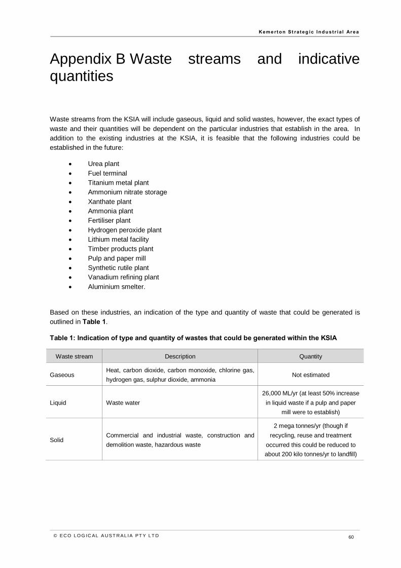
K em e rt o n St ra t eg ic In d u st r i a l Ar ea
© EC O LO G IC AL A U ST R AL IA PT Y LT D 60
Appendix B Waste streams and indicative quantities
Waste streams from the KSIA will include gaseous, liquid and solid wastes, however, the exact types of waste and their quantities will be dependent on the particular industries that establish in the area. In addition to the existing industries at the KSIA, it is feasible that the following industries could be established in the future:
• Urea plant • Fuel terminal • Titanium metal plant • Ammonium nitrate storage • Xanthate plant • Ammonia plant • Fertiliser plant • Hydrogen peroxide plant • Lithium metal facility • Timber products plant • Pulp and paper mill • Synthetic rutile plant • Vanadium refining plant • Aluminium smelter.
Based on these industries, an indication of the type and quantity of waste that could be generated is outlined in Table 1.
Table 1: Indication of type and quantity of wastes that could be generated within the KSIA
Waste stream Description Quantity
Gaseous Heat, carbon dioxide, carbon monoxide, chlorine gas, hydrogen gas, sulphur dioxide, ammonia
Not estimated
Liquid Waste water 26,000 ML/yr (at least 50% increase
in liquid waste if a pulp and paper mill were to establish)
Solid Commercial and industrial waste, construction and demolition waste, hazardous waste
2 mega tonnes/yr (though if recycling, reuse and treatment
occurred this could be reduced to about 200 kilo tonnes/yr to landfill)


K em e rt o n St ra t eg ic In d u st r i a l Ar ea
© EC O LO G IC AL A U ST R AL IA PT Y LT D 61
HEAD OFFICE Suite 4, Level 1 2-4 Merton Street Sutherland NSW 2232 T 02 8536 8600 F 02 9542 5622
SYDNEY Level 6 299 Sussex Street Sydney NSW 2000 T 02 8536 8650 F 02 9264 0717
ST GEORGES BASIN 8/128 Island Point Road St Georges Basin NSW 2540 T 02 4443 5555 F 02 4443 6655
CANBERRA Level 2 11 London Circuit Canberra ACT 2601 T 02 6103 0145 F 02 6103 0148
NEWCASTLE Suites 28 & 29, Level 7 19 Bolton Street Newcastle NSW 2300 T 02 4910 0125 F 02 4910 0126
NAROOMA 5/20 Canty Street Narooma NSW 2546 T 02 4476 1151 F 02 4476 1161
COFFS HARBOUR 35 Orlando Street Coffs Harbour Jetty NSW 2450 T 02 6651 5484 F 02 6651 6890
ARMIDALE 92 Taylor Street Armidale NSW 2350 T 02 8081 2681 F 02 6772 1279
MUDGEE Unit 1, Level 1 79 Market Street Mudgee NSW 2850 T 02 4302 1230 F 02 6372 9230
PERTH Suite 1 & 2 49 Ord Street West Perth WA 6005 T 08 9227 1070 F 08 9322 1358
WOLLONGONG Suite 204, Level 2 62 Moore Street Austinmer NSW 2515 T 02 4201 2200 F 02 4268 4361
GOSFORD Suite 5, Baker One 1-5 Baker Street Gosford NSW 2250 T 02 4302 1220 F 02 4322 2897
DARWIN 16/56 Marina Boulevard Cullen Bay NT 0820 T 08 8989 5601 F 08 8941 1220
BRISBANE Suite 1 Level 3 471 Adelaide Street Brisbane QLD 4000 T 07 3503 7191 F 07 3854 0310
1300 646 131 www.ecoaus.com.au