kensington union bay properties ltd. crown lands
TRANSCRIPT

KENSINGTON UNION BAY PROPERTIES LTD. CROWN LANDS MANAGEMENT PLAN
UNION BAY, COMOX VALLEY REGIONAL DISTRICT, AREA A
Aquaparian Environmental Consulting Ltd. (Aquaparian) was retained to complete environmental services for a proposed project within Union Bay on behalf of the client, Kensington Union Bay Properties Ltd. (Kensington). As part of these services, Aquaparian is completing an application for a temporary License of Occupation on behalf of Kensington so that site investigations can be conducted. The following is a Management Plan that is required as part of the application. A site location map for the project area has been included as Figure 1. A detailed site plan can be found in the attachments to this document as Figure 2.
Consultant Team Contacts:
Name Email Firm Responsibilities
Sarah Bonar [email protected] Aquaparian Environmental Consulting Ltd
• FLNRORD Authorizations • Habitat Assessment & Offset
Requirements • Marina Impact Mitigation
Joline Widmeyer
Michael Sloan
SLR Consulting • Upland Environmental Assessments
• ENV Authorizations • Disposal at Sea Authorization for
Marina Sediments Matt Friderichs
Adam Cooper
McElhanney • Marina & Sheet Pile Wall Design • Site Development and Related
Permitting
Kevin Bodnar
Alexander Gossen
GeoPacific • Geotechnical Assessments and Requirements for the Sheet Pile Wall and Development Construction
1.0 BACKGROUND
1.1 Project Overview
Union Bay is located approximately 13km south of the city of Courtenay and is accessible from Highway 19A. The small bay connects to Baynes Sound. Union point is located north of Union Bay and is the location of a sizeable coal waste pile. As understood, the site was historically used as a shipping port for the Union Coal Company in Cumberland from the late 1800s until the mid 1900s.
The development plan for the Kensington lands includes mixed commercial and residential use of several upland parcels extending north of Union Point. The project proposes to also develop a marina and boardwalk within the bay. The proposed marina requires dredging most of the

basin of Union Bay to achieve a functional depth for the marina. Mechanized test drilling is required to sample and analyse the sediments to determine disposal options of the dredgate.
The area for the proposed test drilling is currently a surveyed provincial crown water lot and zoned as Mixed-Use Commercial-Residential (MUCR) by the Comox Valley Regional District. This crown water lot encompasses most of the bay and a peninsula on the east side of the bay. It is legally identified as follows:
• THAT PART OF BLOCK B, DISTRICT LOT 419, TOGETHER WITH UNSURVEYED CROWN FORESHORE OR LAND COVERED BY WATER BEING PART OF THE BED OF UNION BAY, ALL WITHIN NANAIMO DISTRICT, SHOW OUTLINED ON SKETCH BELOW, CONTAINING 2.936 HECTARES, MORE OR LESS.
The public boat ramp, the breakwater and a section along the west side of the bay, which is developed as a gravel parking area for the boat ramp, are currently under separate leases (PIN SID: 11556891 & PIN SID: 11556921) held by the non-profit organization referred to as the Union Bay Community Club Boat Launch Committee.
The upland properties including the head of the bay are parcels that are owned by Kensington Union Bay Estates (Kensington). An intertidal section of the head of the bay is included in this private ownership. A sheet pile wall that will support a boardwalk/promenade storefront for commercial business is proposed to be installed along the property line and backfilled within the intertidal area within the privately owned lands.
The marina, proposed breakwater extension and eastern peninsula boardwalk are within a crown water lot. The east side of the bay is formed by a small peninsula angled to the southeast that is comprised of anthropogenic fill and coal slag waste and was once part of the historical coal loading wharf. The opening of the bay is 150m across between the end of the rock breakwater and the end of the spit creating a sheltered embayed area that appears to have in-filled over time. The substrate in the bay is fully exposed during very low tides.
Figure 2 is a map indicating the subject crown lot relative to the project area and the license tenures held by the non-profit organization.
PROJECT DESCRIPTION
This application is to apply for a temporary License of Occupation to conduct test drilling to determine sediment composition and to determine dredgate disposal options.
The proposed development plan for a marina will comprise approximately 80% of the bay. The proposed layout of the marina will include the following:
• Breakwater extension, • Marina with capacity for up to 160 vessels ranging from 20’ to 60’, • Float plane access, and • A restaurant.

1.2 Investigative work
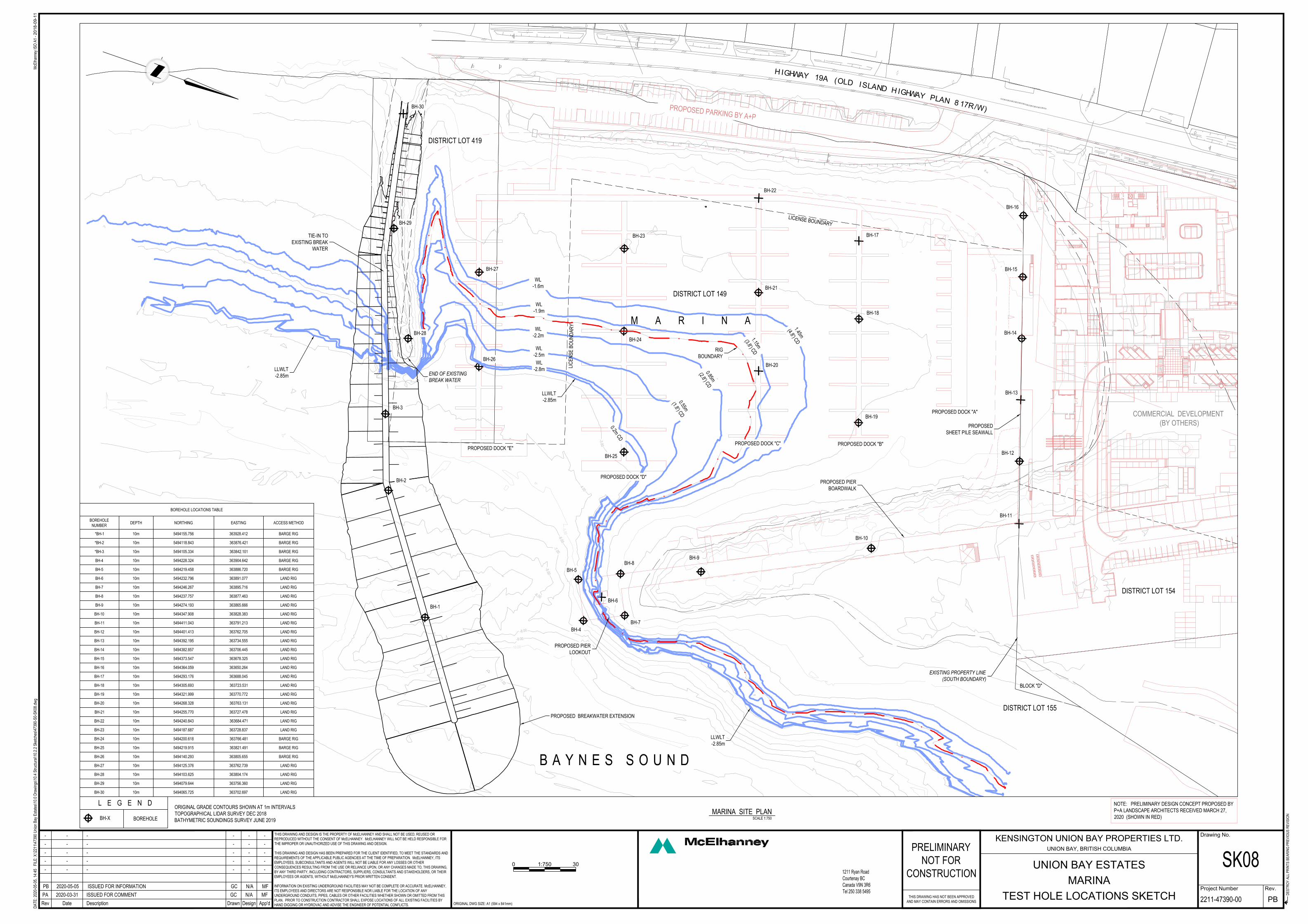
Activity: Test drilling (See Figure 3 for a Site Plan of the proposed test drilling holes)
Description: A barge-mounted sediment drilling rig will access the bay during high tide. A total of 30 test holes will be competed to investigate substrate conditions and will be concentrated around proposed structure locations including:
• Existing breakwater (3 holes) (PIN SID: 11556891), • New breakwater/breakwater expansion (3 holes) (PIN SID: 11556891), • Pier (5 holes), • Mooring piers (6 holes), • Sheet pile wall (6 holes), and • Peninsula fill (2 holes).
Status: Proposed
1.3 Authorization, Permits, Approvals
• N/A for the test drilling phase.
1.4 First Nations
Preliminary discussions are ongoing between the local First Nations and Kensington.
2.0 LOCATION
2.1 General Description
The proposed location of the marina is within Union Bay located in Electoral Area A – Baynes Sound – Denman/Hornby Islands the Comox Valley Regional District (CVRD). Union bay is accessible from Highway 19A and presently contains a parking lot, a boat launch and a breakwater. The peninsula and most of the bay are within provincial crown lands. The bay connects to Baynes sound, a notable fishing area. The marina plan is designed to fit the shape of the bay and will require some modifications such as increasing depth and the length of the breakwater.
2.2 Location Justification
A. The subject crown lease lot is adjacent to the upland owned by Kensington.
Union bay is adjacent to a series of large parcels located within the upland area north of the bay which are owned by Kensington Properties Union Bay Ltd. As mentioned, the overall project scope is to create a waterfront neighbourhood of mixed residential and commercial development. The marina component associated with the development plan for the privately owned upland will require a crown land lease.

B. Union Bay has a long history of historical impacts and relatively limited habitat value.
The site location has a long history of historical industrial impacts from use as a coal loading and shipping port. North of the bay, Union Point is the location of a sizeable coal waste pile that is scheduled for remediation by the province. The upland around Union Bay including the peninsula is constructed from fill for the development of the coal loading and shipping facility and contains coal slag waste. The area is considered a brownfield site and has little habitat value. Likewise, the intertidal area of Union Bay was deemed to be of low quality habitat value and was found to have contamination including coal waste and heavy metals within the sediments. The detailed design will incorporate shoreline remediation along the east side of the peninsula and will aim to improve habitat quality and reduce shoreline erosion.
C. Union Bay contains the only boat ramp access to Baynes Sound in the area.
The closest alternative boat ramps are Big Rock Boat Ramp in Campbell River to the north or Qualicum Boat Launch to the south. As understood, detailed design may incorporate improvements to the existing boat ramp, which is currently only accessible at the highest tides.
2.3 Seasonal expectation of use
The temporary License of Occupation is proposed to be completed in the fall of 2020 and will is expected to be completed within a week.
3.0 INFRASTRUCTURE
3.1 New Facilities or Infrastructure
The temporary License of Occupation application only concerns the test drilling phase of the project. No “improvements” apply to this phase.
3.2 Access
The temporary License of Occupation application only concerns the test drilling phase of the project. Public access will not be impeded by this phase.
3.3 Utilities Requirements and Sources
The temporary License of Occupation application only concerns the test drilling phase of the project. No utilities are required for this phase.
3.4 Water Supply
The temporary License of Occupation application only concerns the test drilling phase of the project. No water requirements are expected.
3.5 Waste Collection, Treatment and Disposal
The temporary License of Occupation application only concerns the test drilling phase of the project. No waste management is necessary for this phase.

4.0 ENVIRONMENTAL
4.1 Land Impacts
4.1.1 Vegetation Removal – No vegetation removal is required for the test drilling phase.
4.1.2 Soil Disturbance – Soil disturbance will be limited to test drilling. Disturbed substrates within the intertidal area are expected to sort and resettle after a tide cycle. The small amount of sediment excavated from the test pits will be taken as sediment core samples and analyzed in a laboratory.
4.1.3 Riparian Encroachment – Not applicable for this project as it is marine and will not include work within or near freshwater.
4.1.4 Pesticides and Herbicides – N/A
4.1.5 Visual Impacts – The visual quality of the Crown Lot will not be impeded by the test drilling.
4.1.6 Archaeological Sites – An archaeological consultant has been retained by Kensington Properties Ltd. for this project.
4.1.7 Construction Methods/Materials- A barge mounted with a drilling rig will be transported from deeper waters into the bay during high tide. The Barge will be positioned by a small tug boat into place to complete test pits that are indicated by the attached site plan. The rig will use a core sample drilling piece to drill down into the intertidal substrate to collect core samples of the sediment. The test drilling is expected to be completed in one to two days.
Environmental Impacts and mitigations in place for the project include the following:
1. Accidental release of hydrocarbons into the marine environment • Full-sized fully stocked spill kits will be on board the barge and an emergency
spill response plan will be prepared prior to drilling activities.
2. Potential turbidity to the marine environment from the drilling activity and barge spuds • Turbidity created as a result of the drilling activity is expected to be temporary
and minor. If excessive turbidity is observed, water quality monitoring will be completed by a Qualified Environmental Professional.
4.2 Atmospheric Impacts
4.2.1 Sound, Odor, Gas or Fuel Emissions – Sound/odor/gas or fuel emissions will not have a deleterious impact on wildlife or disrupt residents in the surrounding area. The drilling activities have minor emissions and will be temporary.

4.3 Aquatic Lands
4.3.1 Drainage Effect – The project will not affect drainage.
4.3.2 Public Access – Public access will not be altered for this activity. The equipment will be imported to the site by barge from deeper waters.
4.3.3 Flood Potential – No flooding risks will result from the proposed test drilling.
4.4 Fish and Wildlife Habitat
4.4.1 Disturbance to Wildlife or Wildlife Habitat - Aquaparian has documented the intertidal habitat within the bay and around the peninsula and the breakwater through a combination of intertidal and subtidal surveys for Environmental Assessments completed for Kensington for various aspects of the proposed project including breakwater expansion and marina dredging. It is Aquaparian’s professional opinion that Union Bay is highly impacted by historical human activity and is comprised of eroding or modified shorelines with a high occurrence of coal waste visible in the substrate. Despite the industrial impacts, there is an abundance of shellfish in the mudflat (low intertidal). It is dominated by Pacific oysters, manila clams and introduced varnish clams. The diversity within the intertidal zone is deemed to be low. Sensitive habitat is limited to some moderately dense eelgrass beds confined to the end of and the south side of the breakwater. The eelgrass bed is to be avoided during test drilling. The proposed test drilling will result in a minor and temporary disturbance to substrate conditions within the bay.
5.0 SOCIO-COMMUNITY
5.1 Land Use
5.1.1 Land Management Plans and Regional Growth Strategies
The embayed area is a surveyed provincial crown water lot (DL 149) and zoned as Mixed-Use Commercial-Residential (MUCR) by the Comox Valley Regional District.
5.2 Socio-Community Conditions
5.2.1 Adjacent Users or Communities – The beach areas and boat launch ramp within Union Bay are used by the public recreationally. The proposed test drilling will not have an impact on public use. If it is required that the area must be secured for the safety of the public (i.e. test drilling near boat ramp may limit boat launching temporarily), it will be a very short duration of time that access is impeded (e.g. several hours/a couple days) and will be correlated with favourable tide cycles for test drilling.
5.2.2 Existing Services – Use of the lease for test drilling will not increase demand on existing services (i.e. fire, ambulance, etc.).


FIGURE 1
LOCATION MAP

Site location
Project area
PROJECT AREAFIGURE 1B
SITE LOCATION MAPFIGURE 1A
FIGURE 2
CROWN LANDS MAP

Legend:
Crown Ownership
Tenure Applications
Approx. Project Test Drilling Area in crown land
FIGURE 2 – CROWN LANDS MAP

FIGURE 3
SITE PLAN
-10.0
0
-5
.0
0
0
.
0
0
-
1
2
.
0
0
-
1
1
.
0
0
-9.0
0
-8
.0
0
-
8
.
0
0
-
8
.
0
0
-
7
.
0
0
-
6
.
0
0
-
4
.
0
0
-3
.0
0
-2
.0
0
-1.00
1.00
2
.
0
0
DE
ST
RO
Y A
LL
P
RIN
TS
B
EA
RIN
G P
RE
VIO
US
R
EV
IS
IO
N
DA
TE
: 2020-05-05, 14:45 F
ILE
: X
:\2211\47390 U
nion B
ay E
states\10.0 D
raw
ings\10.4 S
tructural\10.2.2 S
ketches\47390-S
0-S
K08.dw
g
Drawn DesignDescriptionRev Date App'd ORIGINAL DWG SIZE: A1 (594 x 841mm)
Rev.
Drawing No.
Project Number
McE
lhanney IS
O A
1 -
20
18
-0
9-1
1
1211 Ryan RoadCourtenay BCCanada V9N 3R6Tel 250 338 5495
PRELIMINARY
NOT FOR
CONSTRUCTION
THIS DRAWING HAS NOT BEEN APPROVED
AND MAY CONTAIN ERRORS AND OMISSIONS
PA 2020-03-31 ISSUED FOR COMMENT GC N/A MF
PB 2020-05-05 ISSUED FOR INFORMATION GC N/A MF
- - - - - -
- - - - - -
- - - - - -
- - - - - -
- - - - - -
KENSINGTON UNION BAY PROPERTIES LTD.
UNION BAY, BRITISH COLUMBIA
UNION BAY ESTATES
MARINA
TEST HOLE LOCATIONS SKETCH
SK08
2211-47390-00 PB
0 301:750
THIS DRAWING AND DESIGN IS THE PROPERTY OF McELHANNEY AND SHALL NOT BE USED, REUSED OR
REPRODUCED WITHOUT THE CONSENT OF McELHANNEY. McELHANNEY WILL NOT BE HELD RESPONSIBLE FOR
THE IMPROPER OR UNAUTHORIZED USE OF THIS DRAWING AND DESIGN.
THIS DRAWING AND DESIGN HAS BEEN PREPARED FOR THE CLIENT IDENTIFIED, TO MEET THE STANDARDS AND
REQUIREMENTS OF THE APPLICABLE PUBLIC AGENCIES AT THE TIME OF PREPARATION. McELHANNEY, ITS
EMPLOYEES, SUBCONSULTANTS AND AGENTS WILL NOT BE LIABLE FOR ANY LOSSES OR OTHER
CONSEQUENCES RESULTING FROM THE USE OR RELIANCE UPON, OR ANY CHANGES MADE TO, THIS DRAWING,
BY ANY THIRD PARTY, INCLUDING CONTRACTORS, SUPPLIERS, CONSULTANTS AND STAKEHOLDERS, OR THEIR
EMPLOYEES OR AGENTS, WITHOUT McELHANNEY'S PRIOR WRITTEN CONSENT.
INFORMATION ON EXISTING UNDERGROUND FACILITIES MAY NOT BE COMPLETE OR ACCURATE. McELHANNEY,
ITS EMPLOYEES AND DIRECTORS ARE NOT RESPONSIBLE NOR LIABLE FOR THE LOCATION OF ANY
UNDERGROUND CONDUITS, PIPES, CABLES OR OTHER FACILITIES WHETHER SHOWN OR OMITTED FROM THIS
PLAN. PRIOR TO CONSTRUCTION CONTRACTOR SHALL EXPOSE LOCATIONS OF ALL EXISTING FACILITIES BY
HAND DIGGING OR HYDROVAC AND ADVISE THE ENGINEER OF POTENTIAL CONFLICTS.
B A Y N E S S O U N D
M A R I N A
SCALE
MARINA SITE PLAN
1:750
END OF EXISTING
BREAK WATER
H
IG
HW
A
Y
19A
(O
L
D
IS
L
A
N
D
H
IG
H
W
A
Y
P
L
A
N
8
1
7
R
/W
)
COMMERCIAL DEVELOPMENT
(BY OTHERS)
LIC
EN
SE
B
O
U
N
D
AR
Y
LIC
EN
SE
B
OU
ND
AR
Y
PROPOSED
SHEET PILE SEAWALL
DISTRICT LOT 419
BLOCK "D"
DISTRICT LOT 155
EXISTING PROPERTY LINE
(SOUTH BOUNDARY)
DISTRICT LOT 149
DISTRICT LOT 154
PROPOSED PIER
LOOKOUT
TIE-IN TO
EXISTING BREAK
WATER
PROPOSED BREAKWATER EXTENSION
PROPOSED DOCK "A"
PROPOSED DOCK "B"
PROPOSED DOCK "C"
PROPOSED DOCK "D"
PROPOSED DOCK "E"
ORIGINAL GRADE CONTOURS SHOWN AT 1m INTERVALS
TOPOGRAPHICAL LIDAR SURVEY DEC 2018
BATHYMETRIC SOUNDINGS SURVEY JUNE 2019
NOTE: PRELIMINARY DESIGN CONCEPT PROPOSED BY
P+A LANDSCAPE ARCHITECTS RECEIVED MARCH 27,
2020 (SHOWN IN RED)
PR
OP
OS
ED
PA
RK
ING
BY
A+
P
BH-1
BH-2
BH-3
BH-5
BH-6
BH-7
BH-4
BH-8
BH-9
BH-10
BH-11
BH-12
BH-13
BH-14
BH-15
BH-16
BH-17
BH-18
BH-19
BH-20
BH-21
BH-22
BH-23
BH-24
BH-25
BH-26
BH-27
BH-28
BH-29
BH-30
BOREHOLE LOCATIONS TABLE
BOREHOLE
NUMBER
DEPTH NORTHING EASTING ACCESS METHOD
*BH-1 10m 5494155.756 363928.412 BARGE RIG
*BH-2 10m 5494118.843 363876.421 BARGE RIG
*BH-3 10m 5494105.334 363842.101 BARGE RIG
BH-4 10m 5494228.324 363904.642 BARGE RIG
BH-5 10m 5494219.458 363886.720 BARGE RIG
BH-6 10m 5494232.796 363891.077 LAND RIG
BH-7 10m 5494246.267 363895.716 LAND RIG
BH-8 10m 5494237.757 363877.463 LAND RIG
BH-9 10m 5494274.193 363865.666 LAND RIG
BH-10 10m 5494347.908 363828.383 LAND RIG
BH-11 10m 5494411.043 363791.213 LAND RIG
BH-12 10m 5494401.413 363762.705 LAND RIG
BH-13 10m 5494392.195 363734.555 LAND RIG
BH-14 10m 5494382.857 363706.445 LAND RIG
BH-15 10m 5494373.547 363678.325 LAND RIG
BH-16 10m 5494364.059 363650.264 LAND RIG
BH-17 10m 5494293.176 363688.045 LAND RIG
BH-18 10m 5494305.693 363723.531 LAND RIG
BH-19 10m 5494321.999 363770.772 LAND RIG
BH-20 10m 5494268.328 363763.131 LAND RIG
BH-21 10m 5494255.770 363727.478 LAND RIG
BH-22 10m 5494240.843 363684.471 LAND RIG
BH-23 10m 5494187.687 363728.837 LAND RIG
BH-24 10m 5494200.618 363766.481 BARGE RIG
BH-25 10m 5494219.915 363821.491 BARGE RIG
BH-26 10m 5494140.293 363805.655 BARGE RIG
BH-27 10m 5494125.376 363762.739 LAND RIG
BH-28 10m 5494103.625 363804.174 LAND RIG
BH-29 10m 5494079.644 363756.360 LAND RIG
BH-30 10m 5494065.725 363702.697 LAND RIG
BH-X
L E G E N D
BOREHOLE
LLWLT
-2.85m
WL
-2.8m
WL
-2.5m
WL
-1.9m
WL
-2.2m
WL
-1.6m
LLWLT
-2.85m
LLWLT
-2.85m
1
.
4
5
m
(
4
.
8
'
)
C
D
1
.
1
5
m
(
3
.
8
'
)
C
D
0
.
8
5
m
(
2
.
8
'
)
C
D
0
.
5
5
m
(
1
.
8
'
)
C
D
0
.
2
m
C
D
PROPOSED PIER
BOARDWALK
RIG
BOUNDARY