kenya ministry of environment and natural resources · carried out by the forestry department of...
TRANSCRIPT

1
Country: Kenya
Project Title: National Integrated Natural Resources Assessment
Project Number: FNPP/...
Starting Date: July 2006
Completion Date: December 2007
Government Ministry
Responsible for Ministry of Environment and Natural
Project Execution: Resources
Signed: ................................. Signed: ....................................
Minister of Environment
and Natural Resources FAO Representative in Kenya
(on behalf of Kenya Government (on behalf of FAO)
Implementing Ministry)
Date of Signature: .......................... Date of signature: ........................
Signed..................................................
Minister for Finance
(on behalf of Kenya Government)
Date of Signature: ...............................
2
Table of Contents
Abbreviations and acronyms........................................................................................................... 3
1 Background and justifications................................................................................................. 4
1.1 Geographic and socio-economic background ................................................................ 4
1.1.1 Location .................................................................................................................. 4
1.1.2 Socio-economic background................................................................................... 4
1.1.3 Climatic variability ................................................................................................. 5
1.2 State of natural resources and information availability ................................................. 6
1.2.1 Forestry resources ................................................................................................... 6
1.2.2 Agricultural resources and agricultural biodiversity............................................... 7
1.2.3 Water Resources ..................................................................................................... 9
1.2.4 Fisheries and aquatic resources............................................................................. 11
1.2.5 Wildlife resources ................................................................................................. 11
1.2.6 Soil resources ........................................................................................................ 12
1.3 Challenges in natural resources conservation and management ................................. 12
1.4 Justifications for an Integrated Natural Resource Assessment (INRA) in Kenya ........ 13
1.5 Scope of the Integrated Natural Resource Assessment................................................. 15
2 Objectives and targets ........................................................................................................... 15
2.1 Overall objective........................................................................................................... 15
2.2 Specific objectives ......................................................................................................... 16
3 Strategy of the project ........................................................................................................... 16
4 Expected outputs and results................................................................................................. 17
5 Project activities.................................................................................................................... 18
6 Project organisation .............................................................................................................. 20
7 Participating institutions ....................................................................................................... 22
8 Role of participating institutions........................................................................................... 24
8.1 Planning and implementation of the project................................................................. 24
8.2 Contributions of the participating institutions.............................................................. 24
8.2.1 Focal institution .................................................................................................... 24
8.2.2 Other contributions from other partners ............................................................... 25
9 Inputs to be provided by FAO .............................................................................................. 25
10 Project duration................................................................................................................. 26
11 Budget ............................................................................................................................... 27
12 Work plan.......................................................................................................................... 28
13 Approach and methods ..................................................................................................... 29
14 Workshops and training .................................................................................................... 31
15 Reporting........................................................................................................................... 31
16 Annexes............................................................................................................................. 33
Annex 1. Logical framework ..................................................................................................... 34
Annex 2. Sample site location ................................................................................................... 39
Annex 3: Terms of Reference .................................................................................................... 40
Annex 4: Work Plan .................................................................................................................. 47
Annex 4: Contributions of the partner institutions ................................................................... 49

3
Abbreviations and acronyms
AGL: Land and Water Development Division, FAO
AGP Plant Production and Protection Division
DRSRS Department of Resource Survey and Remote Sensing
EMCA: National Environmental Management and Coordinating Act
FAO: Food and Agricultural Organization of the United Nations
FAO/HQ: Food and Agricultural Organization Headquarters
FAOR: Food and Agricultural Organization Representative
FD: Forestry Department, FAO
FIRI: Inland Water Resources and Aquaculture Service, FAO
FNPP: FAO Netherlands Partnership Programme
FORM: Forestry Resource Development Service, FAO
FRA: Forestry Resource Assessments
GIS: Geographical Information Systems
GPS: Geographical Position System
GDP: Gross Domestic Product
INRA: Integrated Natural Resources Assessment
KIFCON: Kenya Indigenous Forest Conservation Programme
MWRDM: Ministry of Water Resources Development and Management
MTU: Multi-sectoral Technical Unit
NEMA: National Environmental Management Authority
NC: National Consultant
NGOs: Non-Government Organizations
NPC: National Project Coordinator
SC: Steering Committee
SoW PGRFA State of the World and Plant Genetic Resources for Food and Agriculture
TCDC: Technical Cooperation among Developing Countries
TCP: Technical Cooperation Programme of FAO
TM: Landsat Thematic Mapper
UNDP: United Nations Development Programme
UK: United Kingdom
WEHAB Water, Energy, Health, Agriculture and Biodiversity
WSSD: World Summit on Sustainable Development
W/M: Work Month

1 Background and justifications
1.1 Geographic and socio-economic background
1.1.1 Location
Kenya lies on the eastern coast of the African Continent, between latitudes 5o4’ north and 4
o40’
south and between longitudes 33o50’ and 41
o45’ east (Figure 1). The Equator bisects the country
almost two equal parts. Most parts of the country lie within the Sudano-Sahelian belt.
It shares boundaries with the Republic of Uganda to the west and the United Republic of
Tanzania to the south, and is also bordering the following countries: Ethiopia in the north, The
Republic of Sudan to the north-west and the Republic of Somalia in the east. The Indian Ocean is
in the southeast and serves as an important outlet and means of international maritime contact
(Figure 1).
Figure 1: Site and location of Kenya
Figure 1: Site and location of Kenya
Kenya occupies total land surface area of 582,644 Km2. Of this, the arid and semi-arid occupy
39% and 41% respectively while the dry sub-humid occupy 7% and moist sub-humid to humid
13%. The moist sub-humid to humid lands are classified as the high potential areas of Kenya,
supporting rainfed agriculture while the dry sub-humid lands have medium potential mainly used
for agro-pastoralism. The rest of Kenya, which includes arid and semi-arid lands (ASAL), is
suitable for pastoralism and wildlife sanctuary and support nearly half the livestock population of
the country.
1.1.2 Socio-economic background
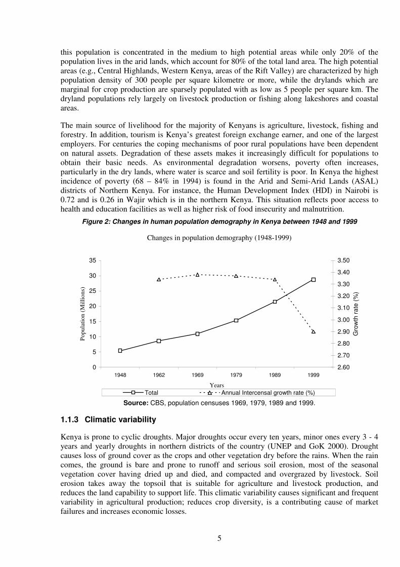
Kenya is a developing country whose population is still largely rural with only 25% living in
urban areas. According to the 1999 census the population of Kenya stood at 29 million, projected
to increase at a rate of 2.5% per year to reach 37.5 million by the year 2010 (Figure 2). 80% of
4°15' 4°15'
3°30' 3°30'
2°45' 2°45'
2°00' 2°00'
1°15' 1°15'
0°30' 0°30'
0° 15' 0°15'
1°00' 1°00'
1°45' 1°45'
2°30' 2°30'
3° 15' 3°15'
4°00' 4°00'
34°30'
34°30'
35°15'
35°15'
36°00'
36°00'
36°45'
36°45'
37°30'
37°30'
38°15'
38°15'
39°00'
39°00'
39°45'
39°45'
40°30'
40°30'
41°15'
41°15'
40
40
0 0
N
EW
S
2000 0 2000 Kilometers
5
this population is concentrated in the medium to high potential areas while only 20% of the
population lives in the arid lands, which account for 80% of the total land area. The high potential
areas (e.g., Central Highlands, Western Kenya, areas of the Rift Valley) are characterized by high
population density of 300 people per square kilometre or more, while the drylands which are
marginal for crop production are sparsely populated with as low as 5 people per square km. The
dryland populations rely largely on livestock production or fishing along lakeshores and coastal
areas.
The main source of livelihood for the majority of Kenyans is agriculture, livestock, fishing and
forestry. In addition, tourism is Kenya’s greatest foreign exchange earner, and one of the largest
employers. For centuries the coping mechanisms of poor rural populations have been dependent
on natural assets. Degradation of these assets makes it increasingly difficult for populations to
obtain their basic needs. As environmental degradation worsens, poverty often increases,
particularly in the dry lands, where water is scarce and soil fertility is poor. In Kenya the highest
incidence of poverty (68 – 84% in 1994) is found in the Arid and Semi-Arid Lands (ASAL)
districts of Northern Kenya. For instance, the Human Development Index (HDI) in Nairobi is
0.72 and is 0.26 in Wajir which is in the northern Kenya. This situation reflects poor access to
health and education facilities as well as higher risk of food insecurity and malnutrition.
Figure 2: Changes in human population demography in Kenya between 1948 and 1999
Changes in population demography (1948-1999)
0
5
10
15
20
25
30
35
1948 1962 1969 1979 1989 1999
Years
Po
pu
lati
on
(M
illi
on
s)
2.60
2.70
2.80
2.90
3.00
3.10
3.20
3.30
3.40
3.50
Gro
wth
ra
te (
%)
Total Annual Intercensal growth rate (%)
Source: CBS, population censuses 1969, 1979, 1989 and 1999.
1.1.3 Climatic variability
Kenya is prone to cyclic droughts. Major droughts occur every ten years, minor ones every 3 - 4
years and yearly droughts in northern districts of the country (UNEP and GoK 2000). Drought
causes loss of ground cover as the crops and other vegetation dry before the rains. When the rain
comes, the ground is bare and prone to runoff and serious soil erosion, most of the seasonal
vegetation cover having dried up and died, and compacted and overgrazed by livestock. Soil
erosion takes away the topsoil that is suitable for agriculture and livestock production, and
reduces the land capability to support life. This climatic variability causes significant and frequent
variability in agricultural production; reduces crop diversity, is a contributing cause of market
failures and increases economic losses.

6
Drought causes shortage of water, overgrazing, shortage of energy and food, which indirectly lead
to loss of biological and economic productivity of the land and as a consequence to seasonal and
in some cases mass movement of people and animals. When severe drought is combined with
poor land use and inappropriate agricultural practices, it results in loss of productivity and
eventually land degradation.
1.2 State of natural resources and information availability
1.2.1 Forestry resources
The forests and trees outside forest play a considerable role for their national economic potential
and the social and environmental benefits they provides at local, national and global levels. These
benefits include the importance of forests for catchment protection, to maintain the hydrological
regime and mitigate soil erosion and sedimentation, climate regulation, medicinal benefits,
employment as well as their significance in terms of export earnings, carbon fixation,
biodiversity, soil and water conservation, protection of indigenous people’ ways of life, cultural
and religious values, and recreational use. The forests and trees outside forest are therefore an
essential part of the fabric of livelihoods in Kenya. They offer the main energy supply; direct
source of food; habitat for wildlife that supports tourism – among the most dynamic economic
activity in Kenya; they also contribute to sustainable agricultural systems; and are a repository for
agro-biodiversity and a major storehouse for carbon and water. It is therefore necessary to
promote sustainable use and conservation of forests. National forest programmes should be seen
as part of poverty reduction strategies.
However, as natural forest are being depleted, biodiversity is declining, timber and non timber
forest products and services are weakened, and most of the important biological endemic species,
that have a potential to sustain the livelihood in the rural areas, are now vulnerable if not extinct.
The first comprehensive forest inventory in Kenya was carried out by the Canadians between
1963 and 1966. Over the next 20 years no work was done in forest inventory. In 1993, activities
sponsored by World Bank identified the need for a comprehensive inventory of plantations in the
country. Following this period, the Kenyan Government undertook a major inventory of industrial
plantations from 1990 through 1993 with the assistance of the FAO through UNDP. The
objectives of the project were institutional strengthening and capacity building, the creation of a
reliable management database and the preparation of management plans for utilization of
industrial plantations. A total of 165,000 ha were earmarked for inventory. However, owing to
several constraints, chief among them being the silvicultural status of some plantations and the
security problems in some regions, only 114,000 ha was inventoried by the end of the project. by
1994 the data collected had become obsolete because of rapid changes, some plantations had been
clear felled, others thinned and new ones planted.
The natural forests, which cover extensive areas in many parts of the country – about 17 million
hectares (FRA 2000) or 30% of the country- have not attracted attention of the decision makers
for national inventory in the recent past despite their important social, economic and
environmental roles. The existing information about Kenya’s indigenous forests is based on work
carried out by the Forestry Department of the Government of Kenya and the KIFCON programme
(Kenya Indigenous Forest Conservation Programme). It is a result of several surveys undertaken
during the programme period 1992-1994 inside indigenous forests and adjacent forest dwelling
communities. A complete inventory of the forest cover in Kenya has not been undertaken in the

7
recent past but efforts have been made to carry out piecemeal assessments in particular areas/
regions depending on the needs and goals (J.K Ndambiri & C.D. Kahuki, 2000).
All forest formations and trees outside forest provide a wide range of goods and services to the
local population. They contribute substantially to the livelihoods of the rural populations. The
extent, social, economic and environmental importance of these resources is not well known to
the national policy makers and consequently, the national policy process is not well informed.
The role of the trees outside the forest and woodlands is also vital in the life of the rural
communities across the country and the knowledge on these resources is quite limited.
1.2.2 Agricultural resources and agricultural biodiversity1
A. Crop and crop-associated biodiversity
The flora and fauna in Kenya’s many ecological zones and habitats include many species of
agricultural or food significance. Kenya is endowed with a unique heritage of diverse germplasm
of vegetables, fruits, oil crops, forages, tubers, cereals and pulses. For example, there are 45
known species of wild vegetable, 200 wild fruit species and 110 multipurpose tree species in
Kenya. This plant genetic diversity has been the subject of considerable research interest and
discussion in various fora (ITDG, 2000, 1999; Maundu et al.; 1999; Chweya & Eyzaguirre, 1999;
MEC, 1998; Guarino, 1997; Kenya Country Report, 1996).
National obligations in agricultural biodiversity are clearly articulated in the relevant CBD
Programme of Work on Agricultural Biodiversity, in the legally-binding International Treaty for
the Conservation and Sustainable Utilization of Plant Genetic Resources for Food and Agriculture
(which Kenya acceded in May 2003), and the Global Plan of Action for the Conservation and
Sustainable Utilization of Plant Genetic Resources for Food and Agriculture (FAO, 1996). Kenya
is also involved in the implementation of the International Pollinators Initiative (under the
Programme of Work on Agricultural Biodiversity of the CBD), notably through its involvement
in the African Pollinator Initiative (API). Assessment of the status and trends in pollinators is a
priority activity for the API. Kenya also prepared a Country Report for the First State of the
World’s Plant Genetic Resources for Food and Agriculture, and will be preparing a second
Country Report to feed into the Second State of the World’s Plant Genetic Resources for Food
and Agriculture. It is expected that these requirements are addressed in recent government
planning documents that focus on the agricultural sector, including the Kenya Agricultural
Research Institute’s strategic plan (KARI, 2000) and the joint strategy for the revitalization of
agriculture by the Ministries of Agriculture & Livestock and Fisheries Development (MOA &
MLFD, 2004). However the extent to which these strategies and plans address sustainable land
use systems and ecosystem functions or services is probably more limited.
The fate of agricultural biodiversity in Kenya is intimately tied to that of the agricultural sector as
a whole, whose challenges are systemic in nature. Capacity issues revolve around reform of
institutional management structures, creation of an enabling legal framework, and local adaptation
and adoption of modern technologies.
1 Agricultural biodiversity is a broad term that includes all components of biological diversity of relevance to food and agriculture, and all components of biodiversity that constitute the agro-ecosystem: the variety and variability of animals, plants and micro-organisms, at the genetic, species and ecosystem levels, which are necessary to sustain key functions of the agro-ecosystem, its structure and processes.
http://www.biodiv.org/programmes/areas/agro/dimensions.asp

8
Cultivated area was about 5.2 million ha in 2002, of which 4.6 million ha arable land and 0.6
million ha permanent crops. Despite the fact that 80 percent of the country is arid and semi-arid,
agriculture in Kenya is dominantly rainfed with an estimated 3.12 million ha being put under food
crops in 1998. The food crops are maize, wheat, sorghum, millets, cassava, Irish and sweet
potatoes, bananas, fruits and vegetables. About 1.5 million hectares were under maize, which is
the primary food for the majority of the population. During the same period, an estimated 500 000
hectares were under industrial crops. Production and income from export crops, such as coffee,
tea, pyrethrum, horticultural crops and cotton, contribute to food security. The main agricultural
imports are wheat, rice, animal and vegetable oils and sometimes maize and sugar in times of
shortage.
Trends in agriculture over recent decades fuelled by commodity driven agricultural policies and
strategies have led to commercial interests driving enterprise selection and reducing farmers’
interest in sustainable systems/rotations. As a result many farmers are producing crops which are
less suited to the agroecological context but for which there is national support (extension, inputs,
markets) and a higher “potential” economic return. Farmers have moved away from more
integrated crop-livestock systems and there has been increasing use of monocultures, resulting in
drier areas in recurrent crop failure and serious effects on livelihoods, food security and
ecosystem resilience.
Livestock and animal genetic resources
The livestock sector contributes about 40% of agricultural GDP and about 10% of the total GDP.
Dairy production is a key source of income to over 60,000 households in the high potential areas.
Ninety percent of beef cattle are in the hands of subsistence farmers and pastoralists. According to
available statistics, Kenya’s cattle population exceeded 10 million heads in 1990.
The sheep population stands at about 5.9 million, the greater share of which is the indigenous
breeds found mainly in the drier areas and hybrids, which do well in the highlands. It is estimated
that the goat population is 7.7 million, most of which are found in the pastoral areas. The size of
the camel population is not well established. Pastoralism is the main livelihood in the country’s
arid- and semi-arid areas.
Emerging livestock comprise ostrich, Guinea fowl, donkeys, snakes for venom and skin
production and crocodiles for skin and meat are also gaining momentum in production. The
ostrich population under domestication is approximately 10,000 and production is concentrated in
the arid and semi arid areas in the Rift valley, Eastern and Coast Provinces. Guinea fowl and quail
are mainly domesticated in western Kenya where they are considered a delicacy. Donkeys are
kept all over Kenya mainly as a beast of burden.
Livestock production systems in Kenya can be broadly categorized as follows:
• Intensive systems in the high and medium agricultural potential areas which is
predominantly under dairy involving exotic breeds and their crosses with indigenous breeds.
Small holder farmers constitute 70% in these systems;
• Ranching and pastoral systems in the rangelands which involve indigenous breeds of
cattle, sheep and goats together with other livestock species such as camel and donkeys. The
rangelands, produces 70%,of total beef consumed in Kenya, the Kenyan rangelands are well
suited for agriculture, a potential that is not fully exploited.

9
Indigenous animal genetic resources offer entry points for suitable utilization of the vast Kenyan
rangelands due to their evolutionary advantage which enables them to adapt to the climatic,
nutritional and disease challenges that prevail in these areas. Indiscriminate crossbreeding, in an
effort to improve on production traits is a risk to the diversity of indigenous animal genetic
resources. However, many of indigenous African animal genetic resources, such as the Kenyan
zebu breeds, are currently at risk of extinction. This trend is partly driven by lack of economic
competitiveness (actual or perceived) of local breeds of cattle, sheep and goats and to a lesser
extent poultry, e.g. indiscriminate cross-breeding, replacement with exotic breeds, introgression
and interbreeding, and the absence of breed development programmes. Other factors include an
increase in size of the human population that has led to a reduction in the amount of land
available for livestock grazing, neglect of traditional livestock production systems, famine and
civil conflict, and cattle rustling and livestock disease epidemics.
Animal genetic diversity allows farmers to select stocks or develop new breeds in response to
changes in the environment, changing market preferences, threats to disease and societal needs,
all of, which are largely unpredictable. Besides, such obvious aesthetic, economic and scientific
reasons, the need to conserve the diverse animal genetic resources could be justified on both
ethical and moral grounds. Although indigenous livestock breeds may not be as productive as
their exotic counterparts, they nevertheless, posses valuable traits such as tolerance and resistance
to disease, high fertility, good maternal qualities, unique product qualities, longevity and
adaptation to harsh environments and poor quality feeds. These qualities are desirable for
achieving sustainable agriculture under low-input conditions. Considering their importance and
endangered status, immediate steps must be taken to conserve these indigenous breeds for use by
both present and future generations (FAO/ UNEP 1995). However until recently, animal genetic
resources have received much less attention than plant genetic resources.
Various studies have been conducted in Kenya, for example, analysis of productivity of various
cattle herds (Sahiwals, various Sahiwal/Ayrshire crossbreds, Small East African Zebus and
Borans) across a range of production systems and management levels. In terms of production
potential, environmental and genetic parameters composite breeds are promising to produce cattle
adapted to major ecological zones and production systems. For example using an optimum
percentage of the highest performing Bos indicus breeds, such as the Sahiwal, to achieve
adaptability to the production environment, combined with Bos taurus breeds which have a high
response capability for milk and beef production. (For Saihiwal, Kenya is an important source of
stock and semen for the continent). However crossbreeding has in many instances led to the loss
of original breeds and to a large extent, the collapse of self-sustaining traditional production
systems. There is growing support for strategies for breed conservation and improvement that
avoid inappropriate breed dilution or replacement.
As with plant genetic resources, there is a need to illustrate current threats to animal domestic
diversity and opportunities for the development of integrated production systems (livestock and
mixed) that allow the maintenance of indigenous animal diversity as an integral part of productive
and sustainable land use systems for various agro-ecological zones.
1.2.3 Water Resources
Kenya’s National Development Plan recognizes the country as water-scarce, whereby the water
demand exceeds renewable freshwater sources. Out of 164 sub-basins with perennial river flows,
it is estimated that 90 will suffer from surface water deficit by 2010 while already 33 sub-basins
without perennial river flow have apparent water shortage.

10
Agriculture is the main user of water and currently consumes about 80% of fresh water resources,
while domestic and commercial use accounts for the rest. One of the main basins presenting the
area with enormous aquatic resources, Lake Victoria is shared with Uganda, Tanzania, Rwanda
and Burundi, supporting one of the densest and poorest rural populations in the world. Surface
water systems and groundwater aquifers constitute the main freshwater reservoirs in the basin.
The Lake Victoria basin faces concerns of water quality and quantity, water supply availability
and accessibility, unsustainable population pressure, water as sources of energy, unsustainable
agricultural practices, loss of freshwater biodiversity, overexploitation of fisheries resources and
introduction of aquatic invasive alien species, and water-borne diseases influenced by scarcity of
clean water (exacerbating incidences of cholera, typhoid, dysentery and certain intestinal parasitic
diseases). Furthermore, deforestation coupled with poor agricultural practices have led to an
accelerated rate of river sediment transport and sedimentation in aquatic or wetland environments.
Pesticides have been introduced either directly by fishermen or indirectly through runoff from
agricultural areas. Recent evidence indicates that gold mining activities along the shoreline or
upstream may be introducing toxic cyanide and mercury into the lake. The amount of pollutants
has far exceeded the filtration ability of the lake margin swamps. Natural resources management
and use in the basin is supported by the large scale Lake Victoria Environmental Management
Programme (LVEMP) and Nile Equatorial Lakes Subsidiary Action Programme of the Nile Basin
Initiative.
Granted through the Water Act 2002, the overall responsibility for water management lies with
the Ministry of Water Resources Development and Management (MWRDM). The ministry’s
current policy (1999) focuses on decentralization, privatization, commercialization and
stakeholder participation. The Water Act 2002 has provided the formation of a Water Resources
Management Authority, responsible for water pollution, and the management of lakes, aquifers
and rivers, and the establishment of a Water Services Regulatory Board, responsible for water
supply through licensed water services providers.
Water use and its effect on the environment is being taken into due consideration, as 30% of the
flow at any point of abstraction has to be reserved for river maintenance and environment. The
National Environmental Management and Coordinating Act (EMCA) No.8 of 1999 is in place to
take care of environmental impact of development and the government has established the
National Environment Management Authority (NEMA) to enforce it. The act makes it mandatory
to conduct an environmental impact assessment before the implementation of a project like for
example large-scale agriculture, use of pesticides, introduction of new animals and plants, use of
fertilizers, and irrigation development.
With the recent drought, the Government is acutely conscious of the problems of loss of
livelihoods, food insecurity and famine caused by recurrent drought and the need to develop more
resilient agricultural systems for arid and semi arid lands. Irrigation and water harvesting are
identified as a top priority; however, it is important to recognise that these require specific
environmental conditions and are not feasible in all locations. An integrated review of land, water
and biological resources that illustrates trends in land use will help the Government to identify
critical changes that have been taking place in farming systems and to take an integrated
ecosystem approach in considering land use systems and investment options for better harnessing
water. In semi-arid and sub-humid areas, there is much that can be done through more drought
resilient systems and soil moisture management that captures and retains limited rainwater on the
land for productive use.
11
1.2.4 Fisheries and aquatic resources
A. Aquatic biodiversity
Aquatic ecosystems provide local communities with natural resources important for sustained
livelihoods. These resources include fisheries, water supply, building materials, pasture and
recreation. These ecosystems are also important for ecological and service roles, namely water
storage, flood control, water filtration, recharge and discharge of water systems. The wetlands are
important wildlife habitats and perform nutrients cycling/storage and related pollution control.
Major Lakes in Kenya include Lake Turkana, Lake Baringo, Lake Naivasha, Lake Jipe, Lake
Chale, Lake Nakuru and Lake Victoria. Some of the swamps include the Yala, Lorian, Shompole
and other swamps that fringe the lakes and provide the buffering capacity. The lakes provide
important ecosystems for both floral and faunal species diversity.
Coastal ecosystems, including mangrove forests, coral reefs and estuaries are of prime importance
to economic growth and conservation. Marine parks and reserves protect marine life, and are
therefore important for biodiversity conservation. They also generate revenue for local population
and the country.
As recently as the 1960s, Lake Victoria supported an endemic cichlid fish species flock of over
500 species, but these have progressively disappeared from the catches to become poorly
represented today. The losses are attributed to habitat degradation in the catchments, introduction
of exotic species (particularly the Nile Perch) and heavy fishing pressure. Incidences of malaria
and bilharzias are common in irrigated areas.
B. Fisheries
Fisheries are the most economically important aquatic resources. Kenya’s fisheries is mainly
composed of freshwater (lakes, rivers and dams) and marine (Indian Ocean) sub-sectors, with
aquaculture still at infancy. The sector contributes about 5% to the country’s gross domestic
product (GDP) with an average producer value of Kenya shillings 8 billion in 2004, and
supported the livelihood of about 500,000 people the same year.
The marine fisheries, especially the Economic Exclusive Zone (EEZ) and Lake Turkana are
under-exploited. Fish production is estimated at 150,000 metric tonnes (MT) annually. Lake
Victoria accounts for over 90% of the national fish production. Marine fish production in Kenya
has shown great fluctuations since 1970s. The greatest production recorded so far from the marine
fisheries has been 8,000 tonnes in one year. Aquaculture contributes less than 1% of the national
fish production. Tilapia, catfish, common carp and trout are the most culture species. Oyster, crab
and shrimp farming is practiced at the coast. There exists a lot of potential for aquaculture to
augment natural sources, hence contributing to biodiversity conservation.
Fisheries and other aquatic resources in Kenya are faced with various threats, among others;
excess fishing effort, illegal fishing, environmental degradation, pollution, unsustainable
development, alien invasive species (e.g. Nile perch, water hyacinth, salvinia and crayfish) and
climate change.
1.2.5 Wildlife resources
Wildlife is a valuable resource to the country’s economy. To conserve the biodiversity, the
Government established the National Parks which currently occupy about 8% of Kenya’s land

12
area. Over 70% of the country’s National Parks and Game Reserves are found in the ASALs
which also hold 2/3 of the livestock population. Livestock and wildlife co-exist in the ASAL
areas while livestock are excluded in the national and game reserves.
The wealth of biological diversity in Kenya is deemed to be high and has been the base for the
livelihoods of many people both at the local and international level. The major threat to genes and
species and ecosystems is loss of natural habitats due to changes in land use patterns and non
comprehensive policies.
1.2.6 Soil resources and land productivity
Soil patterns in Kenya are influenced by altitude, landforms, geology and climate. A generalized
soil map of Kenya has been compiled on the basis of information contained in the Exploratory
Soil Map of Kenya (scale 1:1,000,000) and other soil maps prepared by the Kenya Soil Survey.
There are 22 major soil types, of which 18 are found in the semi-arid and arid areas (ASALs) of
the country. The soils of ASALs greatly vary in their physical and chemical characteristics, and
substantially they are either saline or sodic or both. The nature of the soil influences the rate of
degradation and its vulnerability to desertification. The soils have been mapped and classified
according to the FAO – UNESCO system.
Kenya has a wide range of soils, including high potential areas in the highlands, however,
progressive declining soil fertility and as a result yield decline and food insecurity are a serious
and widespread concern in Kenya. Nutrient depletion results from continuous cropping and land
fragmentation due to population pressures and inappropriate management practices. In the
productive highlands, population densities reach 500-1,000 people per km2. In other areas
unpredictable and erratic rainfall are compounded by the declining soil fertility. For most cereal
and legume crops grown, nutrients are removed in the harvested parts for consumption or sale and
crop residues are used as animal fodder or as fuel or in some cases as trash lines. Manure
produced on the farm maybe returned to the fields or sold but is often not managed well. For the production of major cereals (maize, wheat, rice, barley and sorghum) the major nutrients
would have to be continuously applied to achieve good crop yields. In many areas farmers do not
have access (poverty, infrastructure, appropriate fertiliser types).
The uptake by smallholders of improved nutrient management techniques such as improved
rotations, compost, N and P fertilisers (which since 1992 are no longer subsidised and thus
expensive) and cover crops or green manures (such as Tithonia diversifolia a common weed), has
been limited. Moreover, a range of integrated practices are required, for example although
composts preserve soil humidity and provide some essential nutrients, they do not provide an
adequate payback in terms of increasing phosphorus levels. Composts or Tithonia use need to be
combined with phosphorous fertilisers. Thus one of the biggest challenges facing agriculture in
Kenya at the moment is to develop soil fertility restoration and nutrient saving technologies that
are low cost, agronomically effective and socio-economically feasible.
1.3 Challenges in natural resources conservation and management
The Kenyan people and natural resources are affected by many environmental, social and
economic problems, including environment degradation, poverty, food security, gender bias
against women and loss of indigenous knowledge. Poverty was estimated2 at about 56% in 2003.
More than half of all Kenyans survive on less than USD 15 a month in rural areas and USD 34 in
2 The Economic Recovery Strategy for Wealth and Employment Creation 2003-2007.

13
urban areas. Moreover, Kenya’s population is growing while the economy is not3. The most
vulnerable regions in Kenya are Nyanza, Coast, Eastern, and Western. In Eastern and Western,
approximately 58 percent of the population live below the poverty datum line, whereas the figures
for Coast and Nyanza are estimated at 62 and 63 percent respectively. To address poverty and
livelihood issues, the Kenya Policy Paper 2002–2006 identified the following priority areas:
capacity building, linkages, networking and information sharing, partnerships and participatory
interventions.
In Kenya, like in many other African countries, land is a critical resource and the basis for
survival and its degradation threatens both the economic and the physical well-being in the
country. Agriculture alone contributes about 26% of the national GDP and employs large segment
of its population. However the integrity of natural resources and ecosystems is being affected,
through processes such as accelerated deforestation, desertification, soil degradation, depletion of
mineral and wildlife resources, diminishing biodiversity, accelerated industrial pollution as well
as losses of water quantity and quality. However to what extent these environmental issues are
assessed at the national level and how much national level policy makers know on them?
There have been many sectoral assessments in Kenya, usually driven by narrow information
needs of national policy makers or institutions targeting one particular aspect or resource.
However, the various components of ecosystems are closely interrelated, and the populations are
using and managing different resources in both aquatic and terrestrial ecosystems. Therefore there
is a necessity of addressing biodiversity and ecosystem functions and services in a holistic way or
through ecosystem approaches. Moreover there is little knowledge or understanding of the
interactions between land use and management practices and natural resources and ecosystems
functions and services.
1.4 Justifications for an Integrated Natural Resource Assessment (INRA) in Kenya
Increasing emphasis is being placed worldwide on the importance of promoting rural
development and increasing the productivity of rural livelihoods including agriculture, forestry
and fisheries. The World Summit on Sustainable Development (WSSD) process led to the
identification of five critical areas for attention water, environment, health agriculture and
biodiversity (WEHAB). However, due to sector approaches and institutions, the inter-linkages
and impacts on livelihoods and environmental services are often neglected. The strategic
framework and vision for NEPAD (New Partnership for Africa's Development) provides
opportunities for increased, concerted efforts through both its Comprehensive Africa Agricultural
Development Programme’s (CAADP’s) and Environmental Action Plan.
In Kenya, like in many other African countries, land is a critical resource and the basis for
survival and its degradation threatens both the economic and the physical well-being of the
Kenyans in the country. However the integrity of natural resources and ecosystems is being
affected, through processes such as accelerated deforestation, desertification, soil degradation,
depletion of mineral and wildlife resources, diminishing biodiversity, accelerated industrial
pollution as well as losses of water quantity and quality. However to what extent these
environmental issues are assessed at the national level and how much national level policy makers
know on them are critical issues to examine and make appropriate decisions.
3 Central Bank of Kenya: Quarterly Financial Report 2001: Gross Domestic Product: Ksh756.7 billion at market
prices by end of 2000. Economic growth 0.5 percent of the population growth.

14
There have been many sectoral assessments in Kenya, usually driven by narrow information
needs of national policy makers or institutions targeting one particular aspect or resource.
However, the various components of ecosystems are closely interrelated, and the populations are
using and managing different resources in both aquatic and terrestrial ecosystems. Therefore there
is a necessity of addressing biodiversity and ecosystem functions and services in a holistic way or
through ecosystem approaches. Moreover there is little knowledge or understanding of the
interactions between land use and management practices and natural resources and ecosystems
functions and services.
In order to respond to those concerns, it is proposed during 2006-7 to develop and test the
approach, methods and tools to conduct an Integrated Natural Resources Assessment (INRA)
starting with a pilot supported under the FAO-Netherlands Partnership Programme (FNPP) and
later implemented country wide with national and donor support. The assessment will cover in
particular: forests, agriculture, wildlife and water resources focusing on agrobiodiversity and
ecosystems services and integrity. The findings will be analysed to identify community, technical
and policy considerations for consideration by land/resource users and policy makers and will
bring the necessary and proper knowledge on the status of the natural resources and on their
mutual influences for harmonising sectoral policies.
The relevant government of Government of Kenya Ministries are interested in such an assessment
as it will generate information that will guide development of more integrated strategies for
reversing degradation and harnessing of the country’s resources for productive purposes (Soils,
Water, Pastures, and Catchment areas).
INRA will build on available data and information systems and assessments, as detailed in the
background review that was undertaken to compile an overview of available data and information
systems in Kenya: “Databases Information analysis on Natural Resources in Sectoral Institutions”
(Frank Msafiri, 2006). Other key assessments that will be used include, among others:
• AFRICOVER, which has completed a full 1:200,000 scale land cover assessment for 100% of
the country (using agreed land classification with 10 neighbouring countries) and has
established a substantial database and capacity in the regional centre for mapping and
development in Nairobi;
• National assessments and reporting on the state of plant genetic resources for food and
agriculture (PGRFA) which is ongoing in 35 countries - including Kenya (with support of
FNPP);
• Global and national assessment and reporting on the status of domestic animal diversity;
• Agro-ecological land resources assessment for agricultural development planning. A case
study of Kenya (FAO/IIASA, 1991) by FAO and IIASA with the Government of Kenya
which advanced AEZ procedures with in depth data collection and analysis and development
of a major GlS-oriented Kenya land resources database at the scale of 1:1 million and a PC
and UNIX workstation based software system. The enhancements encompass representation
of multiple cropping systems, livestock and crop sector integration, assessment of fuelwood
productivity, optimization of land use. This analytical tool facilitates the integration of
ecological, technological, social, demographic and economic recommendations for the
appraisal of land resources of individual districts in Kenya for policy formulation and
development planning.
• A recent remote sensing study of trends in Kenya’s agriculture for the period 1970 – 2000
which identifies hotposts and bright spotsand to which LADA (land degradation assessment
of drylands) will add more variables during 2006 – e.g. forest, urban, water, rangeland.
• Poverty mapping for Kenya, based on demographic data prepared by WRI.

15
1.5 Scope of the Integrated Natural Resource Assessment
The integrated natural resources assessment (INRA) will cover the forest and trees outside forest
resources as well as crop and crop-associated biodiversity, livestock, wildlife, soil, water and
aquatic resources with focus on the agrobiodiversity.
The list of resources to include in the field survey will be defined by the project team after
consultation with the concerned institutions and stakeholders. The survey will provide key
information at the national level on the state, extent, uses management and functions of natural
resources.
The assessment will cover a range of biophysical and socio-economic variables and indicators
that can be easily measured, observed or obtained from interviews of key informants
representative of the spectrum of owners, managers and/or users of the resources.
The INRA model being applied in Zambia, which was developed from the national forest
assessment (NFA), will be further adapted to the Kenyan context and interests of stakeholders as
well as to incorporate agro-biodiversity, food security and livelihood dimensions. The assessment
will be conducted at national scale with a design process that will be piloted in selected areas in
three major agro-ecological zones: humid lake zone, arid and semi-arid lands and coastal zone.
The assessment will include biophysical and management dimensions, uses of products and
services, users, as well as conflicts, values and marketing issues. The development process will be
conducted through a technical consultative process for example, specialist working groups,
technical guidance, testing and validation of assessment methods in the pilot areas.
In addition to assessing status and trends of individual natural resources and change in land use,
the methodology development process will assist the Kenya inter-sectoral team to develop and
validate indicators and methods to assess the status and trends of agricultural ecosystems (and
their integrity), threats to agrobiodiversity, ecosystem functions, resilience to drought,
vulnerability to climate variability and change, effects on food security, etc. Efforts will be made
to integrate and illustrate linkages among natural resources, agricultural biodiversity and food
security dimensions (the 3 FNPP themes). The assessment could take into account hot spots and
bright spots that could be identified, for example, through mapping of socio-economic drivers
such as population and poverty with overlays on biophysical factors such as vegetation cover.
Efforts will be made to ensure that the assessment responds to key policy questions, for example,
effects of land use /farming system changes on food security, poverty and vulnerability to drought
During the 18 month project (FNPP_2) selected policy question could be answered, but with
eventual donor support for a more comprehensive analysis, the process could be further applied
and scaled up to guide policies and decision making at national and sub-national levels.
2 Objectives and targets
2.1 Overall objective
The overall objective of the project will be to promote integrated assessment of natural resources
for policy formulation, institutional capacity building, planning, conservation and utilization of
natural resources on a sustainable basis to reduce poverty, enhance food security, create

16
employment and wealth, while taking into consideration indigenous knowledge and the role of
women in natural resource management.
2.2 Specific objectives
1. Identify information needs and adapt methodology and approach to Integrated Natural
Resource Assessment (INRA) through participatory process and build national
capacity to carry out countrywide INRA
2. Assess status of natural resources by implementing the new INRA approach within
pilot zones for later up-scaling to cover the entire country including the development
and validation of indicators and methods to assess agrobiodiversity and agro-
ecosystems and effects on food security and livelihoods through selected pilot areas.
The assessment will cover use, users and management of natural resources in
particular indigenous knowledge and the role of women and youth in natural resource
management.
3. Building on INRA findings, carry out policy impact analysis and cross-sectoral studies
to support inter-sectoral policy dialogue.
3 Strategy of the project
Considering the Government priorities of capacity building, knowledge development and
information sharing on land use resources, the project is designed as direct response to those
Government priorities to be implemented following the participatory approach and to integrate, to
the extent possible, a wide range of natural resources (forest, crop associated biodiversity,
pollinators, soils, wildlife, agriculture, livestock, water and aquatic resources). The project is
developed to create a complete picture about the location, state and quality of the resources at the
national scale, and trends in management and exploitation up to the current state.
To reach the planned objectives (see sections 2.1 & 2.2) the project will follow a strategy founded
on:
1. Capacity building and skill enhancement: the project will provide the necessary input to
develop the national capacity of the concerned institutions to plan and implement
integrated natural resource assessments as well as long-term monitoring of
environmental/ecological impacts.
2. Partnerships building for Kenya’s national Integrated Natural Resources Assessment
(INRA). In order to implement this component, the project will work to build national
partnership and to establish national consensus on approach to INRA and on the thematic
scope of the INRA.
3. Policy driven INRA undertaking with emphasis on the social, economic and
environmental benefits of the resources.
4. Information frameworks harmonization: the project will reach national consensus on
harmonisation of data collection and data management systems at the national level.
5. National database development on use of natural resources and necessary capacity
strengthening for information management and sharing.
6. National ownership of the project: the organisation and implementation of the project
activities will be driven by national institutions, with minimal external inputs.
17
7. Long term monitoring programme for natural resources by institutionalizing a natural
resources assessment unit.
8. Supporting inter-sectoral policy dialogue and harmonization.
The project, which aims at national integrated resources assessment of identified natural
resources, will be implemented in three phases as outlined in Section 12. In the first phase, a first
group of activities will be implemented to develop the experience and skills within the national
institutions, reach consensus about the approach and build the necessary partnership and alliances
to carry out a pilot assessment in the western part of the country. The second phase will be
dedicated to complete the pilot assessment, refine the approach, strengthen the capacity and
expand the survey over the entire country. The third phase will be committed to field
implementation and database development and management, which will depend on the
availability of the financial resources.
4 Expected outputs and results
In support of Objective (1):
1.1 Participation of major users of natural resources data in information needs
identification enhanced.
1.2 National consensus on approach and method to INRA and long-term monitoring of
ecological impacts established.
1.3 Needs of information on natural resources identified through specialised ad hoc
working groups and consultations and workshop processes.
1.4 National institutions strengthened to plan and conduct nationwide assessment of
natural resources including monitoring, presentation of results and management of
information.
1.5 Equipment procured and installed.
1.6 National expertise for INRA reinforced and consolidated.
1.7 Vegetation types/Land use classification system developed and harmonized, up to
date map and analysis produced.
In support of Objective (2):
2.1 Field survey for data collection planned and carried out, focusing on the socio-
economic and environmental benefits of natural resources management.
In support of Objective (3):
3.1 National Natural Resources Database reviewed, improved and made operational.
3.2 Field data captured, processed and analysed.
3.3 Project results discussed and published.
3.4 Cross-sectoral policy analysis and major issues of poverty, environment
degradation, water, biodiversity, etc, addressed.

18
5 Project activities
For Output 1.1: Participation of major users of land use resources data in information
needs identification enhanced.
1.1.1 Identify partners to implement and/ or cosponsor some project activities;
1.1.2 Set up a Steering Committee (SC) to oversee and provide guidance to the project.
1.1.3 Convene national seminars for representatives of partners and stakeholders to
inform about the project and exchange on best ways to implement it and meet all
users’ needs from thematic and quality point of view.
For Output 1.2: National consensus on approach and method to INRA and long-term
monitoring and ecological impacts established.
1.2.1 Through consultations between national professionals and scientists, review the
model approach of resources assessment and resources monitoring to INRA
proposed by FAO-Forestry Department, adapting it to integrate agrobiodiversity,
integrated ecosystem, food security and other human dimensions.
1.2.2 Establish specialised working groups to develop the various agrobiodiversity and
agroecosystems indicators and assessment methods and provide guidance to field
teams for example for linking biophysical and human dimensions.
Convene a national workshop and as required specific task forces involving professionals and
scientists from the concerned sectors to review and agree on the approach.
1.2.3 Finalize the approach and publish for launching the project
For Output 1.3: Needs of information on natural resources identified.
1.3.1 Carry out a comprehensive review of needs of information on natural resources
including forest, trees, land and water and biodiversity and prepare a list of
biophysical and socio-economic variables of the resources taking into account the
necessity to harmonise the national database with global information requirements.
The core list of variables prepared by FAO will be used as basis of this assessment.
1.3.2 Convene national workshop involving representatives of partners and stakeholders
to review and agree on the harmonised national list of variables.
For Output 1.4: National institutions to plan and conduct nationwide assessment of natural
resources including monitoring, presentation of results and management of information
strengthened.
1.4.1 Assess national experiences in the area of natural resources assessment and
information management.
1.4.2 Define human resources needs for office and field tasks and capacity building
needs for planning and implementation of the integrated natural resources
assessment.
1.4.3 Define needs of equipment for the national database.
1.4.4 Review the institutional environment dealing with the natural resource system and
recommend improvements for close collaboration in long-term monitoring of
resources and information management and sharing.

19
For Output 1.5: Equipment procured and installed
1.5.1 Specify and procure the needed equipment for planning and implementation of
field survey, data entry, storage, modelling and processing.
1.5.2 Initiate procurements and storage
For Output 1.6: National expertise for INRA reinforced and consolidated
1.6.1 Plan and carry out training of the national team in field surveys for integrated
natural resource assessment.
1.6.2 Plan and carry out training of the national team in the area of data processing and
analysis, information management and dissemination.
For Output 1.7: Land use systems classification developed and harmonized, up to date map
and analysis produced
1.7.1 Build on existing classification systems of vegetation types and land uses
developed by AFRICOVER in the region and the system used by FRA, and more
specifically by INRA-Zambia, in developing the Kenyan Integrated natural
resources (and agrobiodiversity) assessment.
1.7.2 Ensure wide dissemination and review of the developed classification system by
professionals, scientists and the SC members.
1.7.3 Finalise the national classification system on the basis of received comments and
inputs from reviewers.
1.7.4 Prepare a manual for the interpretation of satellite images and map production.
1.7.5 Support in the design and preparation of a national forest/land use map based on
the harmonised legend with reference and use of the Africover map.
For Output 2.1: Field survey for data collection planned and carried out, focusing on the
socio-economic and environmental benefits of natural resources.
2.1.1 Prepare a manual targeted at field crews describing the approach and techniques to
follow for data collection and materialisation of permanent sample sites in the
field.
2.1.2 Plan and carry out representative field sampling in selected pilot sites (phase 2) to
be extended to the rest of the country (phase 3).
2.1.3 Set up the monitoring system, including registering the permanently established
sample sites for periodic data collection and updating of baseline information and
change assessment.
For Output 3.1: National Natural Resources Database reviewed, improved and made
operational
3.1.1 Develop a functional database on natural resources including forest and TOF, other
natural resources and biodiversity compatible with existing national databases in
the country.
3.1.2 Convene an informative meeting of partners and stakeholders about the structure
and extent of the database and feedback.

20
For Output 3.2: Field data captured, processed and analysed
3.2.1 Develop a manual for data processing and analysis emphasizing on harmonising
project results in the country as well as with international information
requirements.
3.2.2 Carry out entry, processing and analysis of the field data and produce results
satisfying wide range of information users.
For Output 3.3: Project results discussed and published
3.3.1 Distribute final report among SC members and other partners for review and
comments.
3.3.2 Convene a national workshop to validate the project results.
3.3.2 Define and put in place a system to disseminate information to all users.
For Output 3.4: Cross-sectoral policy analysis and major issues of poverty, environment
degradation, water, biodiversity, etc, addressed
3.4.1 Set up a multi-disciplinary team to review and carry out analysis of the policy
framework in the light of the findings of the project and of the thematic studies
carried out under the FNPP and recommend improvements and measures to
harmonise them.
3.4.2 Convene a national workshop to review and agree on the recommendations on
policy harmonisation.
6 Project organisation
The organisation of the project will be set up at the Department of Resource Survey and Remote
Sensing (DRSRS) designated as Focal Institution. The project will be led by a full time National
Project Coordinator (NPC) who will be appointed by the DRSRS.
The NPC will work to:
• promote, liaise and maintain close working cooperation with the national institutions;
• prepare and update the project work plans;
• facilitate training of the crew –members;
• create conditions for implementation of the work plan;
• secure nomination of the national professional staff for the Multi-sectoral Technical Unit
(MTU);
• supervise, guide and monitor all the project personnel;
• oversee fieldwork and secure timely deployment of the necessary logistical support to the
field crews.
• report to the Steering Committee.

21
A national Multi-Sectoral Technical Unit (MTU) will be created. The role of the MTU will be to
plan the project activities, oversee their implementation, provide the necessary logistical support
to the field teams during their fieldwork, monitor and provide guidance to the teams for quality
data collection, organise data encoding in the computer and database development and data
processing. Under the guidance of the NPC, the MTU will be responsible of the timely
implementation of the project activities and of the quality of the results.
To improve the performance of the project, the MTU will be supervised by a National Steering
Committee (SC) that will be set up to oversee the FNPP activities in Kenya. The SC will
comprise experts from the forest, environment, agriculture and other economic sectors. The SC
main duty is to monitor the planning and implementation of the project activities, to provide
guidance to the project team, to advise on information sharing and help overcome constraints
especially those in connection with inputs from all the concerned parties and deployment of
resources. Efforts will be made to ensure that relevant agrobiodiversity related institutions/experts
would contribute to this process and, in turn, results would feed into the policy level activities on
agrobiodiversity, forestry and food security (FNPP national steering committee).
The SC would be composed of representatives from key participating institutions as agreed during
the stakeholders workshop held in Norfolk Hotel in March 2006. The national SC was proposed
to be composed of Permanent Secretaries from the following key partner institutions:
1) Ministry of Environment and Natural Resources (Implementing Ministry)
2) Ministry of Agriculture
3) Ministry of Water
4) Ministry of Tourism & Wildlife
5) Ministry of Livestock & Fisheries
6) Ministry of Lands
7) Ministry of Home Affairs
8) Ministry of Planning and National Development
9) FAO
10) Two NGOs representatives
11) One representative of Private Sector
The SC will be meeting every three months under the chairmanship of the Director of the
DRSRS.

22
Figure 3: Organisation of the project
7 Participating institutions
The strategy of the project implementation requires effective participation of and coordination
between all the concerned institutions to ensure that their collective efforts are directed towards
achieving the objectives of the project namely an improved knowledge on the resources and their
trends, a harmonised inter and intra-sectoral policies.
The stakeholders’ workshop on March 2006 identified sectors that are relevant in natural resource
assessment and management with a view to identifying key institutions that will be partners in the
implementation of INRA and will play active role in the planning and implementation of the
project (see Table 1).
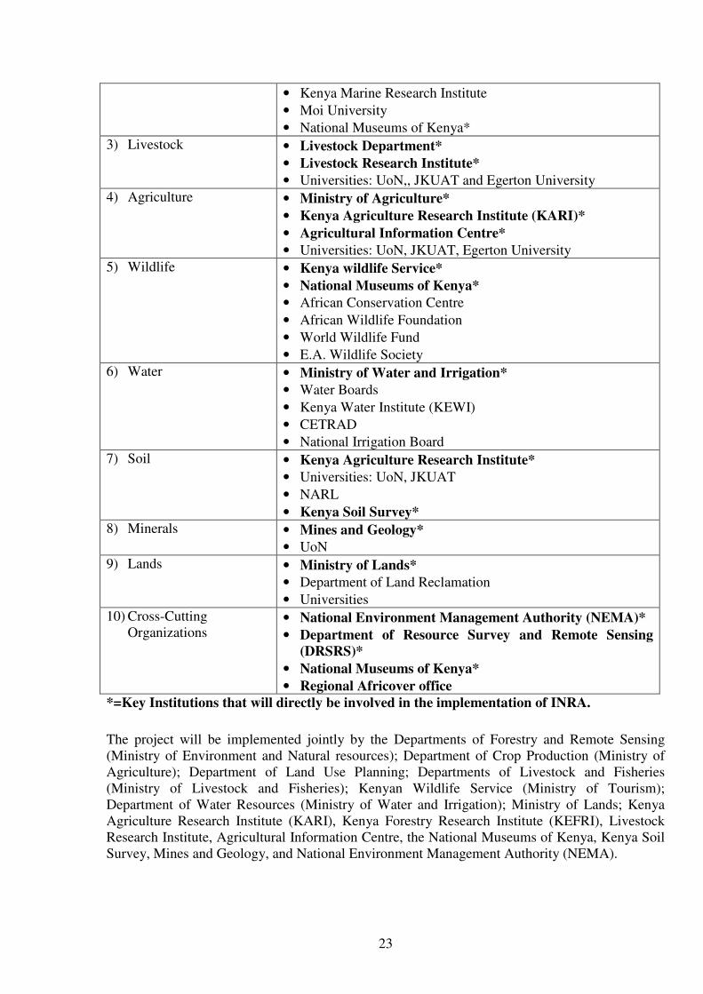
Table 1: Sectors and Institutions involved in natural resource management and assessment
SECTOR INSTITUTIONS
1) Forestry • Forest Department*
• Kenya Forestry Research Institute*
• Kenya Forest Working Group
• Forest Action Network
• Green Belt Movement
• ICRAF
• Tree on Farms Network of ASARECA
• Moi University
2) Fisheries • Fisheries Department*
FAO Universities
& NGO
Research
institutes Forestry Agriculture Water Livestock
Survey of
Kenya
Fisheries
Multi-sectoral
Technical Unit
National Steering Committee
National Project
Coordinator
Field Teams
National Database on Natural
Resources Land use
Mapping
DRSRS (Focal
institution)
23
• Kenya Marine Research Institute
• Moi University
• National Museums of Kenya*
3) Livestock • Livestock Department*
• Livestock Research Institute*
• Universities: UoN,, JKUAT and Egerton University
4) Agriculture • Ministry of Agriculture*
• Kenya Agriculture Research Institute (KARI)*
• Agricultural Information Centre*
• Universities: UoN, JKUAT, Egerton University
5) Wildlife • Kenya wildlife Service*
• National Museums of Kenya*
• African Conservation Centre
• African Wildlife Foundation
• World Wildlife Fund
• E.A. Wildlife Society
6) Water • Ministry of Water and Irrigation*
• Water Boards
• Kenya Water Institute (KEWI)
• CETRAD
• National Irrigation Board
7) Soil • Kenya Agriculture Research Institute*
• Universities: UoN, JKUAT
• NARL
• Kenya Soil Survey*
8) Minerals • Mines and Geology*
• UoN
9) Lands • Ministry of Lands*
• Department of Land Reclamation
• Universities
10) Cross-Cutting
Organizations • National Environment Management Authority (NEMA)*
• Department of Resource Survey and Remote Sensing
(DRSRS)*
• National Museums of Kenya*
• Regional Africover office
*=Key Institutions that will directly be involved in the implementation of INRA.
The project will be implemented jointly by the Departments of Forestry and Remote Sensing
(Ministry of Environment and Natural resources); Department of Crop Production (Ministry of
Agriculture); Department of Land Use Planning; Departments of Livestock and Fisheries
(Ministry of Livestock and Fisheries); Kenyan Wildlife Service (Ministry of Tourism);
Department of Water Resources (Ministry of Water and Irrigation); Ministry of Lands; Kenya
Agriculture Research Institute (KARI), Kenya Forestry Research Institute (KEFRI), Livestock
Research Institute, Agricultural Information Centre, the National Museums of Kenya, Kenya Soil
Survey, Mines and Geology, and National Environment Management Authority (NEMA).

24
The partners will be represented in the supervisory and technical meetings and will provide
guidance to the technical team of the project. Other institutions will also be consulted and
involved throughout the project phase in the area of their expertise and data input.
The project will be based within the premises of DRSRS, mandated to be the focal point of INRA
during the multi-stakeholders workshop. The overall responsibility of the project implementation
will be vested with the DRSRS.
8 Role of participating institutions
8.1 Planning and implementation of the project
Each of the participating institutions will be involved in the planning and implementation of the
project activities. These include review and adaptation of the INRA general approach, analysis of
the existing information framework in all the sectors and their format, identification of gaps,
design of the national database and overall supervision of the project through arrangements put in
place e.g. Steering Committee and Project Technical Unit. All the partners have, under the
leadership of the DRSRS, the overall responsibility for the project. They are responsible of
reviewing and adopting the project work plans, identifying the needs and mobilising the inputs,
securing timely implementation of the project activities and delivery of the expected outputs.
Each partner institution will designate the required and qualified personnel for the Steering
Committee as well as for the Project Technical Unit and will provide personnel for the field
activities and database.
8.2 Contributions of the participating institutions
8.2.1 Focal institution
The DRSRS will have the overall co-ordinating role, including the training of the national
personnel, the adjustment of the approach to INRA. The DRSRS will act to reinforce and develop
its capacity of land use assessments and information management at national, provincial and
district levels. A Unit will be mandated to develop and maintain the base information on land use
resources up to date. The envisaged Terms of Reference for the DRSRS are as follows:
Immediate Action:
• Nominate the National Project Coordinator (NPC) and;
• Set up the national Steering Committee to oversee the project implementation, facilitate inputs
to the project in all phases, ensure wider dissemination of results and provide guidance as how
sustainability of the project findings are ensured at the long run;
• Set up the Project Technical Unit as proposed during the multi-stakeholders workshop of
March 2006.
At the near future:
• Provide physical facilities (offices for staff and database, training space, communication
means, etc.);
• National counterpart staff at secretariat and professional level;
• National personnel for data collection in the field and for data entry and processing.

25
• National personnel and facilities for the mapping component
• Convening the stakeholders meetings
The DRSRS will also provide the existing spatial information (Landsat TM scenes and thematic
maps) and will design and timely produce a harmonized Vegetation type /land use map.
Interpretation and production of the map will be carried out. The project will meet the cost of
field reconnaissance and checking of the interpretation, supplies and material for the production
of the map and international expertise. The DRSRS will be responsible of the whole process of
the map production, but will collaborate with involved stakeholders in defining a harmonised land
use classification system, field truthing of the interpretation using inputs from the field teams. The
DRSRS will deliver a digital map.
8.2.2 Other contributions from other partners
Other contributions from other partners will include:
• Local transportation for the entire fieldwork (14 vehicles for 9 months) and to support NTU
(4 vehicles: 3 vehicles for 9 months and 1 vehicle for 30 months);
• Technicians for the field teams (to be decided later).
• 1 specialist for each partner institution to work within the PTU.
• Database staff (1 specialist and 4 technicians from all the concerned institutions).
• In-kind contribution to cover: salaries of personnel each partner assign to fieldwork and
database and the field allowance (per-diem).
9 Inputs to be provided by FAO
The FAO Representative in Kenya will be operationally responsible for the project and the Forest
Resources Development Service (FORM) will, through the programme of Support to National
Forest Assessment, be responsible for coordinating the technical inputs, with AGL on land and
water issues, AGP on plants, AGA on livestock and FIRI on fish and aquaculture. The national
counterpart in Kenya will be the DRSRS.
The personnel services provided by the project are described in the following table (Table 2).
Table 2: Personnel Services
Activities supported Experts /consultants Months
Training and supervision TCDC Consultants TCDC-1 Integrated Natural resources
assessment and database management
expert
5 mths/
1.5 years
(2 missions)
Total (TCDC) 5 mths
NFA: Planning and supervision
Data processing and analysis
Policy Analysis
NPC National Project Coordinator
National Consultants
NC-1 Integrated Natural Resources
Assessment
18 mths
16 mths

26
NC-2 Data Processing and analysis
NC-3 Policy analyst
NC-4 Mapping and Remote sensing
NC-5 Agrobiodiversity consultants
6 mths
4 mths
6 mths
6 mths
Total (NC) 40 mths
Overall supervision and training Advisory Technical Services FORM (4 missions)
AGL and AGP (3 missions)
FIRI (1 mission)
• 6 weeks
• 3 weeks
• 1 week
Total Advisory Technical Services 10 weeks
Materials, supplies and equipment
• Procurement of specialized field equipment.
• Procurement of computer equipment and other office supplies to set up and run the database.
• Procurement of satellite images.
10 Project duration 18 months.
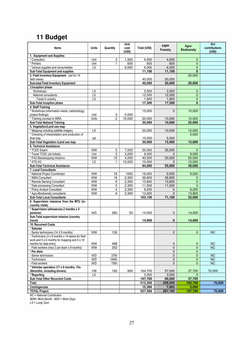
27
11 Budget
Items Units Quantity Unit cost (US$)
Total (US$) FNPP Forestry
Agro-Biodiversity
Gvt contributions
(US$)
1. Equipment and Supplies * Computers Unit 3 1,500 4,500 4,500 0 * Printers Unit 1 600 600 600 0 * Various supplies and consumables LS 6,000 6,000 6,000 0 Sub-Total Equipment and supplies 11,100 11,100 0
2. Field Inventory Equipment (set for 14 field crews) 40,000 20,000
20,000
Sub-total Field Inventory Equipment 40,000 20,000 20,000
3.Inception phase Workshops LS 3,500 3,500 0 National consultants LS 12,000 12,000 0
Travel in country LS 1,800 1,800 0 Sub-Total inception phase 17,300 17,300 0
4. Staff Training * Workshops (information needs, methodology, project findings) Unit 3 5,000
15,000 0 15,000
* Training courses to INRA Units 2 10,000 20,000 10,000 10,000 Sub-Total National Training 35,000 10,000 25,000
5. Vegetation/Land use map * Mapping including satellite imagery LS 20,000 10,000 10,000 * Checking of interpretation and production of final map set 10,000 5,000
5,000
Sub-Total Vegetation /Land use map 30,000 15,000 15,000
6. Technical Assistance
* TCDC Expert W/M 5 7,000 35,000 35,000 0
* Travel TCDC (air tickets) Unit 3 3,000 9,000 0 9,000
* FAO Backstopping missions W/M 10 4,000 40,000 20,000 20,000
* ATS AG LS 1 10,000 10,000 0 10,000
Sub-Total Technical Assistance 94,000 55,000 39,000
7. Local Consultants
* National Project Coordinator W/M 18 1000 18,000 9,000 9,000
* INRA Consultant W/M 16 2,300 36,800 36,800 0
* Remote Sensing Consultant W/M 6 2,300 13,800 13,800 0
* Data processing Consultant W/M 5 2,300 11,500 11,500 0
* Policy Analyst Consultant W/M 4 2,300 9,200 0 9,200
* Agro-Biodiversity consultants W/M 6 2,300 13,800 0 13,800
Sub-Total Local Consultants 103,100 71,100 32,000
8. Supervision missions from the MTU (in-country visits)
* Supervision (allowances 2 months x 5 persons) W/D 280 50 14,000 0 14,000
Sub-Total supervision mission (country travel) 14,000 0 14,000
10. Recurrent Costs
* Salaries
- Senior technicians (14 X 9 months) W/M 126 0 0 NC - Technicians (3 x 9 months x 14 teams for field work and 5 x 6 months for mapping and 5 x 18 months for data entry) W/M 498 0 0 NC
- Field workers (max 2 per team x 9 months) W/M 252 0 0 NC
* Per diem 0 0
- Senior technicians W/D 3780 0 0 NC
- Technicians W/D 14940 0 0 NC - Field workers W/D 7560 0 0 NC
* Vehicles operation (17 x 9 months, 1Vx 30months, including drivers) V/M 183 900 164,700 57,000 37,700 70,000
* Reporting LS 3,000 3,000 0
Sub-Total Other Recurrent Costs 167,700 60,000 37,700
Total 512,200 259,500 182,700 70,000
Contingencies 15,366 7,683 5,000
TOTAL Project 527,566 267,183 187,700 70,000
NC = National Contribution W/M= Work Month - W/D = Work Days LS = Lump Sum

28
12 Work plan
The work plan (see Annex 4) will be implemented in three phases.
Phase 1, of about three months, will be dedicated to the preparations for the fieldwork including
methodology adaptation and information needs identification. An awareness meeting will be held
for the partner institutions and stakeholders. Two workshops will also be organised. The first to
review and adapt the approach to Integrated Natural Resources Assessment and the second to
define the information needs.
Phase 2 will be of about four months and include training of the national staff, designation of
national staff to the project, assignment of transportation means. Under this second phase, the
fieldwork will start with pilot zones distributed in selected areas (see sample location map in
annex 2). The phasing of the fieldwork will allow refining the field survey approach, training the
field teams and assessing financial needs to extend the work in the whole country. The database
application will also be developed.
Phase 3 of eleven months will include the nation-wide fieldwork for data collection by the field
teams (9 months), interpretation of the satellite images (mapping activities). The data processing
and analysis, policy analysis and harmonisation, reporting and evaluation of the project findings
will be undertaken, including cross sectoral studies. Important logistical support will be provided
to have non-stop work in the field by the teams and continuous supervision by the MTU team.
The supervisory team will secure homogeneous data collection by all the teams, correct
interpretation of the definitions of the variables and their entry in the field forms. The field forms
will be collected by the supervisory group and assembled at the database unit of the project for
encoding by the database personnel. The information system will be set up, and the national
personnel in charge will be trained to manage collected data.
Project phases can be detailed as follows:
Phase 1: Project planning, partnership building and methodology adaptation (preparation)
• Build partnership for Kenya's INRA and long term monitoring: identify key participating
stakeholders and other agencies and define their roles and responsibilities.
• Prepare a detailed work-plan for project activities.
• Assess national experiences in the area of natural resources assessment and information
management and identify information needs and gaps with key stakeholders.
• Identify human resource and capacity building needs.
• Identify and procure the needed equipment for project activities.
• Adapt and refine FAO general approach to INRA to national context and requirements
through consultation between professionals and scientists.
• Define with stakeholders biophysical and socio-economic variables be considered in the
field implementation of the project, with particular emphasis on gender and indigenous
knowledge.
• Develop and agree upon a harmonized vegetation/land use classification system.
Phase 2: Capacity building for field implementation, pilot phase and database development
• Carry out training of the project teams in field surveys following the agreed approach for
field inventory for INRA.
• Carry out a data collection in the field in selected pilot areas.

29
• Develop of national centralized database for field data, harmonized with existing national
databases.
• Capacity building in field data processing and data management.
• Analysis of results in pilot areas.
• Improve methodology learning from pilot phase experience.
• Carry out training of the project team in data management and dissemination.
Phase 3: National field implementation, mapping, data analysis and reporting
• Capacity building of field staff for up-scaled INRA (hands-on training).
• Expand the field survey to the rest of the country.
• Carry out mapping activities.
• Consolidate the database.
• Carry out data entry, processing and analysis of field data and produce results satisfying
wide range of information users.
• Carry out cross-sectoral studies in particular assess and document indigenous knowledge
of natural resources as well as the role of women and youth in natural resource
management.
• Validation, reporting and dissemination of findings.
• Set up mechanisms for maintenance of the permanent sample plots and continuous data
collection.
• Develop and operationalize the national information sharing mechanism and establish
backup mechanisms for data security
• Support inter-sectoral policy dialogue and harmonization, and carry out policy impact
analysis.
13 Approach and methods
The FAO model approach to INRA will be adopted and adapted to national context and
information requirements. The approach was designed to harmonise data collection techniques
and data processing and to respond to country’s as well as international growing needs of
information. It is based on a number of considerations such as cost effectiveness, timeliness,
complexity/rapidity of data collection/updating procedures, accuracy and consistency of output
data (in space and time), compatibility of outputs with those from other systems of data collection
(e.g. SoW PGRFA) and flexibility in land use classification/characterisation (e.g. adaptability to
changes in scale and level of generalisation); capacity to rapidly facilitate a broad range of
analysis in response to various decision making needs. It has the potential of responding to
different and changing national international needs:
• Assessing natural resources for decision making at national level policy makers:
• Extent and state of resources (areas, volume, biomass, biodiversity, etc);
• Products and services;
• Management, use and users of resources;
• Role of natural resources in food security and poverty alleviation.
• Setting up a long term monitoring system of resources;
• Developing and strengthening national capacity in integrated natural resources
assessments, information management and long term monitoring;
• Contributing to increasing awareness of and knowledge about the multiple functions of
natural resources;

30
• Developing harmonized land use classification, terms and definitions with international
reporting systems. This is to produce comparable information between successive
inventories in the country and to facilitate reporting to the international processes;
• Forging partnerships between national institutions and with regional and international
agencies;
• Guiding investment and socio-economic development programmes in the country.
Fieldwork is a crucial activity for the training of national personnel. The planned outputs will
depend largely on it. Permanent observation sites will be established for long-term monitoring of
natural resources. GPS is a key instrument in locating plots with the assistance of
latitude/longitude coordinates defined in advance on the topographic maps.
Around 500 sample sites are planned for field data collection distributed in the country according
to a systematic latitude/longitude grid (see Annex 2). The sampling scheme will be systematic and
stratified according to agro-ecological zones. In stratum 1, more heterogeneous, diverse and
populated, the sample sites will be located at higher sampling density, set at 15 min x 10 min. In
the rest of the country (stratum 2) falling mostly under the dry ecological zone and composed
essentially of tropical shrub-land, the sampling intensity is lighter and is set at 30 x 30 minutes.
Each sample site is a tract of 1 km2 with four 20 m X 250 m (5,000 m2) sample plots located at
250 m from each other (see figure below).
Measurements of resource characteristics will be done in all natural resources categories (forest
and trees, crops and agrobiodiversity, livestock, wildlife etc). Observations of vegetation type,
health, diversity extent, spatial location and human activities will be recorded. Variables will be
defined for this purpose during a workshop in the first phase of the project. Interviews of key
informants from local communities, NGOs and entrepreneurs, etc will be done in every sample
site to identify the major users of resources (men, women, children and other groups, the products
and services used, the way these are managed and used). A household survey will complement the
information on livestock and farming system. According to needs to adequately capture
agrobiodiversity and agroecosystems dimensions the method will be reviewed to ensure it
adequately captures change in habitat (e.g loss of cattle grazing and wildlife migration corridors,
250 m
Plo
t 1
Plo
t 3
Plot 4
500 m
1 Km
1 K
m
Plot 2
Tract
Plot orientation

31
dryseason grazing lands, habitat for pollinators etc.) as well as species and intra-species
considerations and loss of ecological function (e.g. effects on hydrological regime).
14 field crews will be created. Each crew will include a representative of the partner institutions
(forester, agriculture, livestock, etc). However for practical reasons, the crews will be optimised to
include the minimum number of technical staff that is able to cover the whole set of data
collection. The field crews will be trained adequately to carry out future surveys and maintain the
established field sample plots. The national multi-sectoral technical unit (MTU) will also be
trained in organization and supervision of the fieldwork.
Complementary mapping will be carried out using recent high resolution satellite data and a
standardized and nationally agreed vegetation/ land use classification. Mapping activities will rely
on existing spatial database such as AfriCover products and will include field validation to the
extent possible.
14 Workshops and training
A budget provision is made for the workshops and in-country training.
• Workshop on the approach to INRA applied to long-term monitoring of the resources
including harmonisation of forest/land use classification, terminology and definitions that
meets national information requirements and facilitates country reporting obligations to
international processes.
• Workshop on natural resources information needs and the required set of biophysical and
management/use variables to be covered by the assessment.
• Workshop on the project findings and validation of the results.
• Two-week theoretical and practical training courses in resources assessment to the national
team from the partner national institutions.
• One-week introductory course to the national field crew members in integrated natural
resources assessment focussing on the classification system, terms and definitions used,
sampling design and field forms, data recording.
• Two-week practical training course to the national field crew members in field survey
following the INRA approach.
15 Reporting
The National Project Coordinator will provide FAO and the relevant technical services through
the FAOR in Kenya, a Quarterly Project Progress Reports summarizing the activities performed,
the progress and outcomes of the project and, a revised work plan for the next period as
appropriate.
Each consultant (international and national) will present at the end of each mission a technical
report containing the main results, conclusions and recommendations of his/her missions. The
NPC under the supervision of the Head of the DRSRS will also prepare the following reports to
be validated by the responsible Lead Technical Unit at FAO/HQ (FORM):
• Report of findings and results of the project. The final report will include a description of
project implementation and all findings of the project.
32
• Report on policy impact analysis and harmonisation.
• Report on thematic studies.
The FAO lead technical unit (FORM), in coordination with the technical expertise associated with
the Agrobiodiversity Theme as well as with other technical units in Rome, will be responsible for
ensuring that the technical reports of consultants are submitted in a timely manner, are technically
sound and will distribute them to other FAO units participating in the project. At the end of every
mission, the FAO officers providing supervisory and advisory technical services will prepare a
technical report with results, conclusions and recommendations and conduct briefings with other
FAO staff as necessary.

33
16 Annexes
Annex 1: Logical framework Annex 2: Sample location map Annex 3: Terms of Reference Annex 4: Work plan Annex 5: Contributions of the partner institutions

34
Annex 1. Logical framework
Specific Objective Expected output-Results Activities Indicators
1.1.1 Based on thematic issues, identify partners
to implement and/ or co-sponsor some project
activities.
• List of partners to implement
and/co-sponsor activities
1.1.2 Set up a Steering Committee (SC) drawn
from identified thematic issues to oversee and
provide guidance to the project.
• List of SC Members
1.1 Participation of major
users of natural resources
data and information
needs identified and
enhanced.
1.1.3 Convene sub-national seminars for
representatives of participating stakeholders to
inform about the project and exchange on best
ways to implement the project taking into
consideration users’ needs and without
compromising the quality of information.
• Number of Seminar held and
proceedings reports
1.2.1 Through consultations between national
professionals and scientists, review the model
approach of resources assessment and resources
monitoring to INRA proposed by FAO, adapting
it to integrate agrobiodiversity and other
dimensions.
• Model approach of resource
assessment reviewed
1.2.2 Convene a national workshop and as
required specific task forces involving
professionals and scientists from the concerned
sectors to review and agree on the approach.
• Workshop report
• Reviewed approach document
1. Identify information
needs and adapt
methodology and
approach to Integrated
Natural Resource
Assessment (INRA)
through participatory
process and build national
capacity to carry out
countrywide INRA
1.2 National consensus on
approach and method to
INRA and long-term
monitoring of ecological
impacts established.
1.2.3 Finalize the approach and publish for
launching the project. • Published approach document
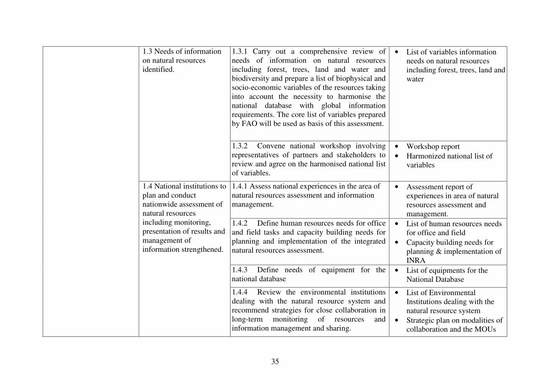
35
1.3.1 Carry out a comprehensive review of
needs of information on natural resources
including forest, trees, land and water and
biodiversity and prepare a list of biophysical and
socio-economic variables of the resources taking
into account the necessity to harmonise the
national database with global information
requirements. The core list of variables prepared
by FAO will be used as basis of this assessment.
• List of variables information
needs on natural resources
including forest, trees, land and
water
1.3 Needs of information
on natural resources
identified.
1.3.2 Convene national workshop involving
representatives of partners and stakeholders to
review and agree on the harmonised national list
of variables.
• Workshop report
• Harmonized national list of
variables
1.4.1 Assess national experiences in the area of
natural resources assessment and information
management.
• Assessment report of
experiences in area of natural
resources assessment and
management.
1.4.2 Define human resources needs for office
and field tasks and capacity building needs for
planning and implementation of the integrated
natural resources assessment.
• List of human resources needs
for office and field
• Capacity building needs for
planning & implementation of
INRA
1.4.3 Define needs of equipment for the
national database • List of equipments for the
National Database
1.4 National institutions to
plan and conduct
nationwide assessment of
natural resources
including monitoring,
presentation of results and
management of
information strengthened.
1.4.4 Review the environmental institutions
dealing with the natural resource system and
recommend strategies for close collaboration in
long-term monitoring of resources and
information management and sharing.
• List of Environmental
Institutions dealing with the
natural resource system
• Strategic plan on modalities of
collaboration and the MOUs

36
1.5: Equipment procured
and installed
1.5.1 Specify the needed equipment for planning
and implementation of field survey, data entry,
storage, modelling and processing.
Initiate procurements and storage
• List of sampling equipments
considering those already with
participating institutions
• Number of tenders for
procurements
1.6.1 Plan and carry out training of the
national team in field surveys for integrated
natural resource assessment.
• Number of field teams trained
on approach for INRA
1.6: National expertise for
INRA reinforced and
consolidated
1.6.2 Plan and carry out training of the
national team in the area of data processing and
analysis, information management and
dissemination.
• Number of national team
trained on data processing,
analysis and information
management and dissemination
1.7.1 Assist in the preparation of a
harmonised classification system of the
vegetation types and land uses. In developing
this, consideration must be taken of the
classifications systems existing in the country
and at international level such as the one used by
FAO for global FRA, Africover, etc.
• Vegetation and land use
classification system
1.7.2 Ensure wide dissemination and review
of the developed classification system by
professionals, scientists and the SC members.
• List of institutions and
individuals considered in the
review of classification system
1.7.3 Finalise the national classification
system on the basis of received comments and
inputs from reviewers.
• Harmonized classification
system
1.7 Vegetation types/Land
use classification system
developed and
harmonized, up to date
map and analysis
produced.
1.7.4 Prepare a manual for the interpretation
of satellite images and map production.
• Developed manual for the
interpretation of satellite
images and maps

37
1.7.5 Support in the design and preparation of
a national forest/land use map based on the
harmonised legend with reference and use of the
Africover map.
• National forest/land use map
2.1.1 Prepare a manual targeted at field crews
describing the approach and techniques to
follow for data collection and materialisation of
permanent sample sites in the field.
• Approach and techniques
manual for field sampling
2.1.2 Plan and carry out representative field
sampling in selected pilot sites (phase 2) to be
extended to the rest of the country (phase 3).
• Number of sampling sites
sampled
2 Assess status of natural
resources by
implementing the new
INRA approach within
pilot zones for later up-
scaling to cover the entire
country. The assessment
will cover use, users and
management of natural
resources in particular
indigenous knowledge and
the role of women and
youth in natural resource
management
2.1: Field survey for data
collection planned and
carried out, focusing on
the socio-economic and
environmental benefits of
natural resources.
2.1.3 Set up the monitoring system including
registering the permanently established sample
sites for periodic data collection and updating of
baseline information and change assessment
• Number of permanent
registered sample sites for
periodic deata collection and
monitoring
3.1.1 Develop a functional database on natural
resources including forest and trees outside
forest, other natural resources and biodiversity
compatible with existing national databases in
the country.
• List of database information
from lead institutions for
database development
3.1: National Natural
Resources Database
reviewed, improved and
made operational
3.1.2 Convene an informative meeting of
partners and stakeholders about the structure and
extent of the database and feedback
• Minutes of informative meeting
of partners and stakeholders
• Draft document on the structure
of the database
3 Building on INRA
findings carry out policy
impact analysis and cross-
sectoral studies to support
inter-sectoral policy
dialogue
3.2: Field data captured,
processed and analysed
3.2.1 Develop a manual for data processing
and analysis emphasizing on harmonising
project results in the country as well as with
international information requirements.
• Reviewed manual on the
structure of the database

38
3.2.2 Carry out entry, processing and analysis
of the field data and produce results satisfying
wide range of information users.
• Number of data forms
processed and analysed
• Draft report on the result of
data
3.3.1 Distribute final report among SC
members and other partners for review and
comments.
• List of SC members and other
partners that reviewed the final
report
3.3.2 Convene a national workshop to validate
the project results. • Report on project report
validation
3.3: Project results
discussed and published
3.3.2 Define and put in place a system to
disseminate information to all users. • Information dissemination
system
3.4.1 Set up a multi-disciplinary team to
review and carry out analysis of the policy
framework in the light of the findings of the
project and of the thematic studies carried out
under the FNPP and recommend improvements
and measures to harmonise them.
• A functional multidisciplinary
team to review and carry out
analysis of the policy
framework
3.4: Cross-sectoral policy
analysis and major issues
of poverty, environment
degradation, water,
biodiversity, etc,
addressed
3.4.2 Convene a national workshop to review
and agree on the recommendations on policy
harmonisation
• Report of the national policy
harmonisation

39
Stratum 1
Annex 2. Sample site location
Stratum 1
(Stratum 2)

40
Annex 3: Terms of Reference
National Project Coordinator (NPC)
Under the direct supervision of Director of the DRSRS and in close consultation with the FAO
National project coordinator and country team, the National Project Coordinator will assume
managerial responsibility of the project, facilitate its smooth implementation and will report to
the DRSRS. The main tasks of the NPC will be to
1. Promote, liaise and maintain close working cooperation with the national institutions and
regional/provincial services with relevance to the INRA project to ensure wide participation
on decision making on the project and secure smooth implementation of all its activities.
2. Prepare and update the work plans of the project. Detailed work plans will be prepared each
meeting of the Steering Committee.
3. Implement project work plans in accordance with the project requirements and ensure timely
delivery of equipment, recruitment of staff, placement of consultants and reporting by them,
study tours and other training activities, arrangement and fieldwork activities and project
reporting.
4. Facilitate the nomination of the national professionals to work in the MTU.
5. Supervise, guide and monitor all personnel, including experts, in project implementation.
Ensure that all reports, manuals and other documentation prepared by experts and their
counterpart are of high quality.
6. Plan and supervise the planning, implementation and monitoring processes of project
activities.
7. Ensure that inputs of the partner institutions into the project, office accommodation and
administrative assistance, equipment, training and personnel are available when required and
are used by the project.
8. Arrange travel and coordination arrangements for study tour.
9. Arrange internal travel in Kenya for international experts and their counterparts to the regions
in accordance with the project needs.
10. Arrange and supervise all workshops, training courses, seminars and fieldwork that are
required for project implementation.
Duration of Assignment: 18 months.
Duty Station: Nairobi, Kenya with travels in the country.
Qualifications: A university degree, preferably at Masters level, in natural resources with
experience of at least 10 years of practical experience in Kenya in resources management,
assessment/inventory, project management.
Language: English.
Recruitment: The National Project Coordinator will be selected and appointed by the
Government and will be required to work Full Time on the Project.

41
Integrated natural resources assessment and database management consultant
(TCDC-1)
Under the direct supervision of Forest Resources Development Service (FORM) and in
collaboration with the national authorities, the consultant will provide the technical assistance
and support to the DRSRS in training of national personnel, planning and implementing the
project activities and setting up the information system.
The main tasks of the consultant will be to:
• Work with the national team from the DRSRS and related Land Use Institutions to review
and adjust when necessary the inventory methodology, vegetation classification, land use
classification and biophysical and socio-economic variables;
• Assist in supervising interpretation of satellite scenes following the vegetation/land use
classification prepared with the national staff and the production of the maps;
• Prepare, in collaboration with the national consultants and FRA/Agrobiodiversity experts, a
training programme for the national personnel involved in the project and assist the DRSRS
in its implementation;
• Participate in the implementation of the training programme for the national personnel
including the team of supervisors, the field crews and database personnel through the
planned workshops and courses;
• Assist DRSRS in purchasing, installing and using the equipment and supplies planned for
the project;
• In close collaboration with the national consultant, prepare a plan of the project activities and
identify timely inputs from the project and the Government;
• Provide supervision to the field crews during the survey and provide technical guidance as to
homogenise data collection and best interpretation of variables and definitions. Frequent
visits to all crews must be carried out throughout the assignment of the expert;
• Assist in organising collection field crews, outputs and filings;
• Work closely with the national land use and information system consultants to develop and
set up a national integrated land use functional database, encode, validate and store the field
data, prepare functions for data processing and initiate data processing;
• Assist in data analysis, reporting of findings and elaboration of the project terminal
statement.
Duration: 5 months.
Duty Station: Nairobi, Kenya with frequent field trips.
Qualifications: The Consultant should have at M.Sc. Natural Resources Management or
equivalent with five (5) years’ working experience in the tropics and a background in integrated
land use assessment design, planning and competence in land use information system
management and have confirmed experience in capacity building and project implementation.
Language: English.
42
National Integrated Natural Resources Assessment Consultant
(NC-1)
Under the direct supervision of the Forest Resources Development Service (FORM) and
technical supervision of the Technical Backstopping Officer in FORM, FAO headquarters, and in
collaboration with the national authorities and the TCDC expert, the national consultant will
assist the DRSRS in training of national personnel, planning and implementation of the national
Integrated Natural Resources Assessment.
The main tasks of the consultant will be to:
• work closely with the NPC and the TCDC expert to prepare a work plan for the project .
• work closely with the national personnel and international consultant and provide inputs for
the elaboration of training programme to the national staff involved in the project and assist
the DRSRS in implementing it;
• participate in implementing the training programme through the planned workshops and
courses;
• assist the DRSRS in planning and running the workshops throughout the project and
securing wide participation of different stakeholders;
• work with professionals from the different sectors and scientists and in close collaboration
with the TCDC expert to reach a consensus on the INRA approach and long-term
monitoring;
• assist in coordinating efforts of the DRSRS to define information needs and harmonize in
close collaboration with the mapping team the land use classification system;
• assist DRSRS in purchasing, installing and using the equipment and supplies planned for the
project;
• in close collaboration with international consultant prepare a plan of the project activities
and identify timely inputs form the project and the Government;
• provide supervision of the field crews during the fieldwork and provide technical guidance
as to homogenize data collection and best interpretation of variables and definitions. All
teams be closely followed during the start of the fieldwork;
• assist in organizing field crews outputs and in filing them;
• in close collaboration with the TCDC expert, assist in developing the national database,
encoding/storing the field data, preparing functions for data processing and undertake data
processing;
• assist in data analysis and reporting of findings;
• prepare the project progress report on the component of inventory and the terminal
statement.
Duration: 18 months WAE.
Duty Station: Nairobi and travel inside the country.
Qualifications: The Consultant should have at least M.Sc. in natural resources management or
equivalent with more than ten (10) years’ working experience and a background in integrated
land use assessment design; planning and competence in land use information system
management and have experience in capacity building and project implementation.
Language: English

43
National Data Processing and Analysis Consultant (NC-2)
Under the direct supervision of the Forest Resources Development Service (FORM) and
technical supervision of the Technical Backstopping Officer in FORM, FAO headquarters, and in
collaboration with the national authorities and the TCDC expert, the national consultant will
provide the technical assistance and support to DRSRS in the areas of capacity building,
institutional strengthening and data processing and analysis. The main tasks of the consultant will
be to:
• Sort, analyse and validate the collected data. This work will be coordinated with the NC-1
and TCDC-1. The NC-2 will analyze the data in accordance with the agreed strategy for
producing results and statistical calculations and store the findings in an easily retrievable
format.
• Refine the analyzed data and compile the relevant sections of the report for submission to the
Government and to FAO. This will be done on the basis of the recommendations from the
workshop on the project findings.
• Ensure that the Focal Institution counterpart personnel fully understand all the work-
processes related to extracting, sorting, processing and analyzing the collected data so that
future repetitions will be possible with the DRSRS’s own capacity.
• Report any technical problems related to the data and the Information System/Database to
DRSRS counterpart and to FAO.
• Describe all work performed in the form of a terminal report at the end of the recruitment
period — to be submitted to and technically cleared by the FAO Lead Technical Unit of FAO
Headquarters. The report should contain: 1. ample descriptions to allow for accurate future
repetitions of the work and; 2. recommendations for possible improvements of the database
application including a description of any technical problems and any ‘bugs’ encountered
during the work.
• Assist in any other tasks under the project at the instruction of the NPC.
Duration: 5 months.
Duty station: Nairobi
Qualifications The consultant should have a strong background in information system
development, database management, statistical analysis and be familiar with MS Access database
application at an advanced level.
Language: Fluency in English is required.

44
National Policy Analyst Consultant (NC-3)
Under the direct supervision of the Forest Resources Development Service (FORM) and
technical supervision of the Technical Backstopping Officer in FORM, FAO headquarters, and in
collaboration with the national authorities and the TCDC expert, the national consultant will
provide the technical assistance and support to DRSRS in the areas of policy impact analysis
involving wide range of institutions concerned and institutional strengthening. The main tasks of
the consultant will be to:
• Undertake review of policies dealing with forestry, agriculture, livestock, rangeland, soil and
water conservation, biodiversity, environment, etc;
• Carry out analysis of the natural resources sectors in terms strengths, weaknesses,
opportunities and threats. Said analysis to be carried out based on project findings, and
existing literature;
• Prepare recommendations to improve policy on natural resources and to engage inter-sectoral
dialogue among national institutions to harmonise the policy framework;
• In close collaboration with the NPC, the FORM Expert, the NC-1, and TCDC Consultant,
convene a three-day workshop to present and discuss results of the review of the different
land use management policies, the natural resources policy analysis and the recommendations
for harmonisation among the economic sectors;
• Prepare a report of the workshop that should define areas of harmonisation between policies,
and follow up actions to consolidate the national dialogue on policy harmonisation;
• Prepare and submit final consultancy report.
Duration: 4 months
Duty station: Nairobi.
Qualifications: The consultant should have at least a M.Sc. degree in policy and planning with a
minimum 10 years experience in activities related to policy and planning.
Language: English required.

45
National Mapping and Remote Sensing Specialist (NC-4)
Under the direct supervision of the Forest Resources Development Service (FORM) and
technical supervision of the Technical Backstopping Officer in FORM, FAO headquarters, and in
collaboration with the national authorities and the TCDC expert, the national consultant will
provide the technical assistance and support to DRSRS in training the national personnel,
planning and implementing the activities in connection with mapping and remote sensing on land
use resources, notably in developing of maps using remote sensing materials such as satellite
images. The main tasks of the consultant will be to:
• prepare inception report and submit to the DRSRS and FAO for comments;
• examine the existing thematic maps on vegetation, land cover and land use and assess their
quality in terms of thematic details, dates of production, methods of production, scale and
precision;
• participate in defining the harmonised land use classification which should be based on the
FAO classification global Forest Resources assessment;
• define specifications of the land use map to be produced by the project and the mapping
methodology and approach to be adopted;
• define the specifications of the needed remote sensing data and assist the DRSRS and the
project Multi-Sectoral Technical Unit in acquisition of satellite images. Use should be made
of existing data and resort to purchase only if the existing data is judged not suitable or
incomplete;
• assist to build capacity in land use mapping to national personnel in the DRSRS and related
staff;
• oversee the entire satellite image interpretation activities, including field checking and
finalisation of the interpretation;
• validate the interpretation results, produce a final map based a harmonized legend and
generate statistical results on areas of the different land use units;
• in close collaboration with FRA Expert, the national integrated natural resource assessment
consultant and the TCDC consultant, prepare mapping storage system;
• prepare and submit final consultancy report describing the planned activities, the method
followed for land use mapping, training programme and beneficiaries and results of the
mapping work and the results aschieved.
Duration: 6 months.
Duty Station: Nairobi with frequent travel inside the country.
Qualifications: The consultant should have at least M.Sc. in information technology or natural
sciences. The consultant should have at least ten years’ experience in institutional support and
administrative management. The consultant should have expert knowledge in integrated natural
resource inventory, GIS, mapping and remote sensing.

46
Agrobiodiversity consultants (NC-5)
The national consultants on agrobiodiversity (NC-AGBIO) will be recruited and under overall
guidance of the FAO Representative in Kenya and will work under the direct technical supervision of
the Kenya Agricultural biodiversity group and the Forest Resources Development Service (FORM),
the lead technical unit. This will be faciliatted through a project task force with the Land and Water
Development Division (AGL), Plant Protection and Production Division (AGP), Animal Health and
Production Division (AGA) and Gender and Population Division (SDW) and Inland Water resources
and Aquaculture Division. The national consultants will work in close collaboration with national
authorities, partner institutions and members of the FNPP project team in Kenya. The consultants will
provide technical assistance in integrating agrobiodiversity issues into Kenya’s Integrated Natural
Resources Assessment (INRA), in particular the main tasks of the consultants will be to:
• work under the daily guidance of the FNPP national coordinator, together with other members of
the INRA team(the national project coordinator (NPC), the TCDC expert and other consultants)
to integrate agrobiodiversity in the INRA approach and methodology;
• assist in defining information needs on agrobiodiversity, indicator selection and data collection
methods for variables on agrobiodiversity with a range of partners and stakeholders;
• assist in the preparation and implementation of the integrated data collection process ensuring an
integrated ecosystem approach, with attention to temporal (e.g. growing seasons, rotations) and
spatial dimensions (landscape to farm), the main components of ecosystems (forest, crop and
livestock based systems in various agro-ecological zones), and ecosystem functions and services;
• contribute to the development of a training programme for the national staff involved in the
project and participate in at least two training workshops for supervisors and field crews;
• assist as required, the national lead institute (DRSRS) in project implementation, with particular
attention to agrobiodiversity concerns, from the selection of indicators and assessment methods,
to data analysis and reporting of findings;
• review opportunities and make suggestions for linking or integrating the INRA database with
existing national and international database and information systems that address relevant
agrobiodiversity issues; and,
• prepare a specific report on data collection, interpretation and documentation of findings on
agrobiodiversity (status, trends, driving forces, pressures, priority issues requiring attention).
Duration: 6 months for tree persons plant related, livestock related and systems functioning part time.
Duty Station: Nairobi and travel inside the country.
Qualifications: The national consultants should have at least M.Sc. in agriculture, biology or natural
resources management with specific knowledge and practical experience in agroecology and/or
agrobiodiversity. Required to have more than seven (7) years’ working experience including
competence in land use information system management and experience in capacity building.
Desirable to have participated in natural resources inventory.
Language: English and Kiswahili.

47
Annex 4: Work Plan
Months Activities
1 2 3 4 5 6 7 8 9 10 11 12 13 14 15 16 17 18
Phase 1: Project planning, partnership building and methodology
adaptation (preparation)
• Recruitment of international and national consultants
• Set up of project organization (identification of partners, set up of
national SC, NMT, co-funding)
• Prepare a detailed work-plan for project activities
• Identify information needs (review of policy issues) and define list
of variables
• Workshop on information needs (thematic working groups)
• Adapt and refine FAO general approach to INRA
• Workshop on approach and methodology
• Identify human resource and capacity building needs
• Identify and procure the needed equipment for project activities
• Develop and agree upon a harmonized vegetation/land use
classification system
Phase 2: Capacity building for field implementation, pilot phase and
database development
• Training of the national multi-sectoral team (NMT)
• Training of field teams
• Carry out a pilot data collection in selected zones (field work and
supervision)
• Improve methodology learning from pilot phase experience
• Develop database INRA
• Training in data entry, field data processing and data management
• Data entry and analysis (pilot)
Phase 3: National field implementation, mapping, data analysis and
reporting
• Capacity building of field staff for up-scaled INRA (hands-on
training)
• Carry out a nationwide data collection (field work and supervision)
• Consolidate the database
• Data entry
• Mapping

48
Months Activities
1 2 3 4 5 6 7 8 9 10 11 12 13 14 15 16 17 18
• Data processing and analysis
• Reporting on findings
• Institutional review on resource monitoring (maintenance of sample
plots, ...)
• Policy impact analysis,
• Support inter-sectoral policy dialogue and harmonization
• Final workshop on project findings (validation) and outline of
follow up programme
Technical assistance and national SC meetings
• Meetings of the national SC
• National Project Coordinator
• TCDC expert
• National Consultant on INRA (NC-1)
• Data processing and analysis (NC-2)
• National Consultant on Policy Analyst (NC3)
• National Consultant on Remote sensing and mapping (NC-4)
• Agrobiodiversity consultants (NC-5) (3 persons plant related,
livestock related and systems functioning part time)
• FORM backstopping
• AGLL and AGP backstopping
• FIRI backstopping

49
Annex 4: Contributions of the partner institutions
Partners Vehicles SC MTU Field Mapping Database
� DRSRS (Ministry of Environment and Natural resources)
2 1 1 8 5 1
� Forestry Department (Ministry of Environment and Natural resources)
2 1 1 8 1
� Department of Crop Production (Ministry of Agriculture);
2 1 1 8 1
� Department of Land Use Planning 2 1 1 8 1
� Livestock Departments (Ministry of Livestock and Fisheries)
2 1 1 8 1
� Fisheries Department (Ministry of Livestock and Fisheries)
2 1 1 8 1
� Kenyan Wildlife Service (Ministry of Tourism)
2 1 1 8 1
� Department of Water Resources (Ministry of Water and Irrigation)
2 1 1 8 1
� Survey of Kenya (Ministry of National Planning)
2 1 1 8 1
� National Museums of Kenya 2 1 1 8 1
� FAO ü ü ü
� Other national and international partners
ü
Totals 20 10 10 80 10 10